Design and Implementation of flood risk management projects in Georgia and Bosnia & Herzegovina Dr. Margaretta Ayoung Chief Technical Advisor, AF/UNDP Project in Georgia and GEF/UNDP Project, B&H Managing Director – AquaLogic Consulting Limited 19 ‐ 20 th March 2015
Transcript
Design and Implementation of flood risk management projects in Georgia and Bosnia
& Herzegovina
Dr. Margaretta AyoungChief Technical Advisor, AF/UNDP Project in Georgia
and GEF/UNDP Project, B&HManaging Director – AquaLogic Consulting Limited
19 ‐ 20th March 2015
• Introduction• General Approach• Projects
oGeorgia ‐ Rioni RiveroBosnia & Herzegovina ‐ Vrbas River Basin
• Summary
Structure
General Approach
Integrated Flood Risk
Management
Enhancing legislative and
policy framework
Technology transfer and capacity building
FRM intervention measures
Enhanced monitoring,
forecasting and early warning
systems
Improved community resilience
Developing Climate Resilient Flood and Flash Flood Management Practices to Protect Vulnerable Communities of Georgia
Project Location: Rioni River Basin, Western GeorgiaProgramme: 4 Years (2012‐2016)Project Value: $5.3 million USDFunding Body: Adaptation Fund
• Rioni River vulnerable to floods, flash floods, landslides, river bed and bank erosion and mudflows
• Annual impact on agriculture, property and infrastructure, and endanger lives
• Annual risk of economic losses caused by potential hydro meteorological disasters reaches $4 billion.
• 1995‐2009 the total cost of damage from floods and flash floods amounted to over $1 billion.
• Frequency and intensity of hydrometeorological hazardous events increasing
Project Background – Climate Change Context
Components
Hazard Mapping
Floodplain zoning
Revised Building Codes
Flood Insurance Scheme
Floodplain Development
Policy
Structural Interventions
Agroforestry Schemes
Community‐based
adaption measures
Flood plain seasonal productive systems
Climate Resilient Practices
Hydrometric Monitoring Network
Flood Forecasting and early warning
Multi‐hazard Risk
Assessment
Capacity Building
Early Warning System
Project Components
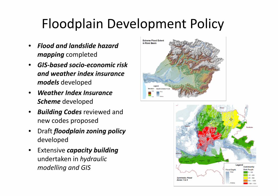
Floodplain Development Policy • Flood and landslide hazard
mapping completed • GIS‐based socio‐economic risk
and weather index insurance models developed
• Weather Index Insurance Scheme developed
• Building Codes reviewed and new codes proposed
• Draft floodplain zoning policy developed
• Extensive capacity building undertaken in hydraulic modelling and GIS
Climate Resilient Practices• Prioritisation of 12 locations for
structural intervention – option appraisal and feasibility studies undertaken
• Detailed design of structural intervention measures for 4 out of 12 location and procurement of contractors
• Design and implementation of agro‐forestry schemes on 4 sites in lower catchment
• Development of Employee Guarantee scheme for community‐based adaptation
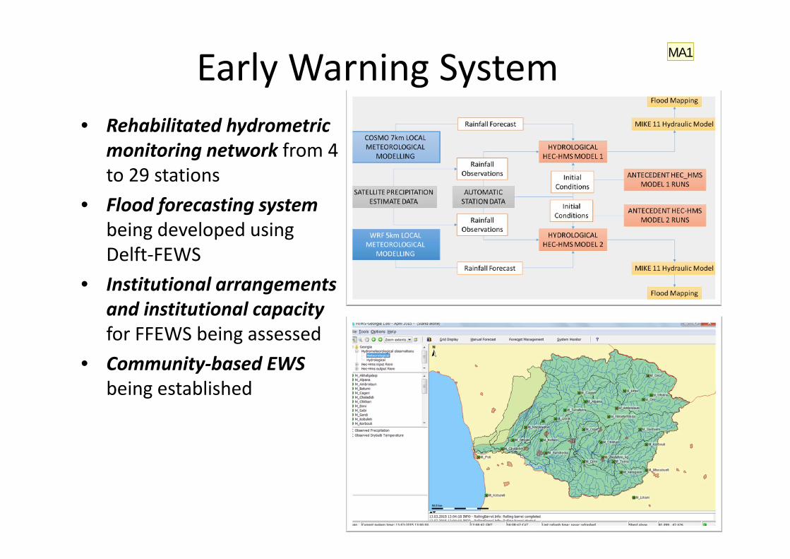
Early Warning System• Rehabilitated hydrometric
monitoring network from 4 to 29 stations
• Flood forecasting system being developed using Delft‐FEWS
• Institutional arrangements and institutional capacity for FFEWS being assessed
• Community‐based EWS being established
MA1
Slide 9
MA1 Awaiting pictures from Vano and screen shots of FFEWS model from JuanMargaretta Ayoung-Monk, 13/03/2015
Reduced exposure to
climate‐related hazards
Enhanced risk knowledge
Tools for modelling and mapping hazard
and risk
Enhanced policy and legislative framework
Financial risk transfer instrument
Structural and Non‐structural Interventions
New and rehabilitated flood and erosion
defences
New non‐structural measures for
enhanced resilience
Introduction of standardised methods for CR intervention
design
Community‐based resilience measures
Strengthened Institutional Capacity
Institutional arrangement enhanced
Tools and capacity for CRM
National guidance documents on all aspects of CRM
Increased community awareness of risks and involvement in risk
management
Long‐term Capacity Development Plan in
place
Forecasting and early warning
Improved monitoring capabilities
FFEWS system including community‐
based schemes
Strengthened CRM capacity
Expected Project Outcomes
Technology transfer for climate resilient flood management in Vrbas River Basin
Bosnia and HerzegovinaProject Location: Vrbas River Basin, Northern BiHProgramme: 5 years (starting 2015)Project Value: $5 million USDFunding Body: GEF/SCCF
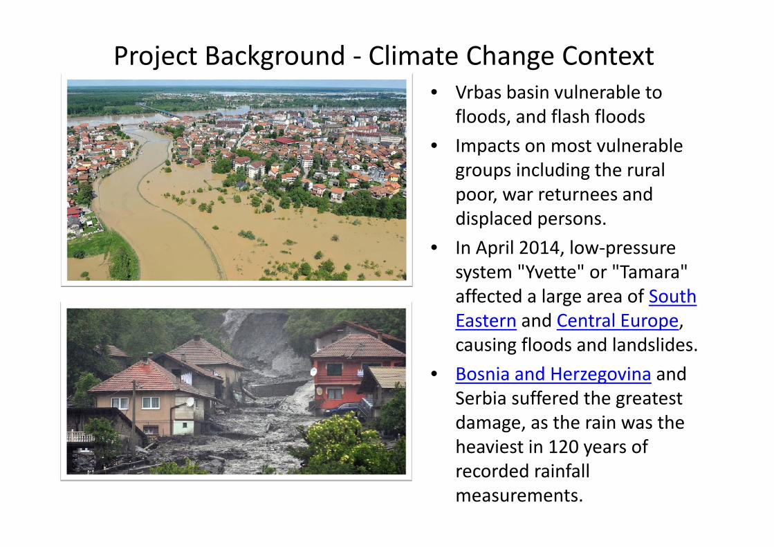
Project Background ‐ Climate Change Context• Vrbas basin vulnerable to
floods, and flash floods• Impacts on most vulnerable
groups including the rural poor, war returnees and displaced persons.
• In April 2014, low‐pressure system "Yvette" or "Tamara" affected a large area of South Eastern and Central Europe, causing floods and landslides.
• Bosnia and Herzegovina and Serbia suffered the greatest damage, as the rain was the heaviest in 120 years of recorded rainfall measurements.
Components
SectoralPolicies and
Plans
Spatial planning
Regulations and Policies
Integrated FRM plan developed
Codification of
technology solutions
Enabling Environment for Climate
Risk
Improved Modelling
GIS‐based assessment tool
Upgraded Hydro‐
meteorological monitoring system
Institutional Capacity
Strengthening
Technical and Institutional Capacity
Non‐structural Measures
Community‐based
adaption strategies
Flood Forecasting and EWS
Capacity Building
Climate Resilient
Technologies
Project Components
Enhance key sectoral policies
and plans
introducing climate change risk
considerations into 2 sector plans
Enhanced spatial planning and
development policy including risk‐based floodplain zoning
Integrated FRM basin plan for Vrbas
Implementation tools and guidelines
elaborated for new policies
CR‐FRM enabled by technology transfer and institutional strengthening
Enhanced risk knowledge
Tools for modelling and mapping hazard
and risk
Centralised hydrometric database
Institutional capacity strengthening plan
Socio‐economic survey tools for systematic data collection
GIS‐based socio‐economic
vulnerability, loss and damages model
Non‐structural CR‐FRM
measures
Design and implementation of non‐structural measures
Farm level training in more flood‐resilient agricultural methods provided to 10,000
farmers
Agro‐forestation scheme implemented on 840 hectares of
floodplain
Feasibility studies and detailed design for at least 3 non‐structural intervention schemes
Index‐based flood insurance scheme
FFEWS system and Increased resilience of
local communities
14 stations established as part of a central hydrometric system
Fully‐integrated FFEWS for VRB implemented
At least 2 community‐based EWS’s implemented.
Strengthened Institutional
Arrangement plan for FFEWS
Community EWS operators and practitioners on
community‐based EWS
Awareness raising and enhanced FRM information dissemination
Expected Project Outcomes
Conclusions
Legislative/Policy Framework
•Enhanced Policy and legislation based on risk knowledge•Resilience in construction•Financial risk transfer instruments
Structural and non‐structural interventions
•Structural for protection to a given SoP ‐ expensive•Non‐structural can enhance structural and manage residual risk•Combination of structural and non‐structural essential
Capacity Building and building community resilience
•National and local institutions enabled•Tools, methods, technology provided•Community risk knowledge •Community‐owned and managed schemes
Enhanced monitoring,
forecasting and preparedness
•Enhanced monitoring and observation capabilities•FFEWS systems•FFEWS institutional arrangements•Awareness raising and information dissemination•Enhanced response capacities