This Scope of Work for the JSPW Modification Project has been amended from the original Bluecoast proposal P194010 submitted on 17 May 2019 to accurately detail the scope of work for public distribution.
Title page photo: Byron Bay aerial photograph from March 2019
Byron Shire Council
Design Investigation for the Modification of the
Jonson Street Protection Works
Consultancy Scope of Work
17 May 2019
This Scope of Work for the JSPW Modification Project has been amended from the original Bluecoast proposal P194010 submitted on 17 May 2019 to accurately detail the scope of work for public distribution.
1.1 General ...................................................................................................................................................... 1
4 CAPABILITIES AND EXPERIENCE ............................................................................. 43
4.1 Statement of capability .......................................................................................................................... 43
4.2 Project team ............................................................................................................................................ 43
This Scope of Work for the JSPW Modification Project has been amended from the original Bluecoast proposal P194010 submitted on 17 May 2019 to accurately detail the scope of work for public distribution.
1 INTRODUCTION
1.1 General
In response to the Byron Shire Council’s (Council’s) Request for Tender 2018-0029 – Design
Investigation for the Modification of the Jonson Street Protection Works (the project brief), Bluecoast
Consulting Engineers Pty Ltd (Bluecoast) is pleased to submit this proposal. Our proposal includes
all submission requirements as set out in Council’s Project Brief.
1.2 Why us?
Bluecoast specialise in coastal engineering, including coastal management and climate change
resilience. We are recognised for our innovative approach to employing cutting edge technology and
research in addressing the needs of our clients. Our staff have carried out a broad range of coastal
engineering projects, often complex in nature, and have provided solutions that benefit from our ‘out-
of-the-box’ thinking. Our expertise covers the full range of project requirements from prefeasibility
and conceptual assessment, through to detailed design, tendering, design and construct project
teams and construction supervision. The JSPW upgrade project is a complex coastal engineering
project and the concept and detailed phase will require a consultant who has proven experience in
resolving the challenges a project of this nature presents. Complex coastal engineering is what we
do, and we do it to the highest standard.
We have an extensive track record in coastal projects in NSW and work with Department of
Planning, Industry and Environment and Council collaboratively to develop future-proof coastal
solutions and understand the policy framework and Coastal Management Plan. To assemble the
optimal mix of expertise, insight and experience required for the JSPW upgrade, Bluecoast has
picked a team of industry-leading and like-minded experts complementing our own skills. We have
work closely with these complementary team members in the past and have a good working
relationship. Being an independent small business, we are in a position to selectively ‘cherry-pick’
the best team for the job ensuring best value-for-money with minimal overheads.
Bluecoast is collaborating with the following experts for the JSPW upgrade:
Tonkin & Taylor – We have an excellent relationship with T&T staff and have appointed Tom Shand
as a Technical Reviewer for this study. Tom has undertaken assessments across NSW and Australia
These include, Assessment of the NSW Extreme Coastal Wave Climate, the results of which are still
used frequently today and Review of the Effects of Seawalls on NSW Beaches for Department of
Planning, Industry and Environment, including the Jonson Street seawall. We also propose to draw
on T&Ts resources and experience for the detailed design phase of the JSPW upgrade. T&T’s multi-
disciplinary team of engineering, scientists and planners offer a comprehensive range of services
related to the enhancement and protection of the coastal edge.
Space Studio – We have teamed with the local architects at Space Studio who were engaged on
the Byron Bay Master Plan team as architects and local consultants. Their role was to advise on
architectural matters such as sub-tropical design, materials and building form, local character and
the built environment. They have also provided advice on local community matters and understand
the need for a bespoke solution reflecting the informal nature of Byron Bay and the broader Shire.
This Scope of Work for the JSPW Modification Project has been amended from the original Bluecoast proposal P194010 submitted on 17 May 2019 to accurately detail the scope of work for public distribution.
Space Studio are on our team to ensure seamless incorporation of the wealth of work completed for
the Masterplan and will be included in the MCA process.
Rhelm – Our former colleagues at Rhelm are specialist consultants in engagement and economics
in coastal management projects. They will draw on their NSW experience to complement the project
team in the planning, environmental, economic and engagement tasks as well as the MCA
assessment. Bluecoast and Rhelm each have a detailed understanding of the NSW policy context
and Coastal Management Plan which will ensure the relevant policy and planning guidelines are
adhered to.
Andrew Short – We invited Andrew to lead our geomorphological assessment in this study. He is
unrivalled in his wealth of knowledge of coastal processes in Australia. Andrew will ensure all the
opportunities and impacts of our proposed concept designs are identified. He will provide a key input
to our multiple-lines of evidence approach, alongside the numerical modelling and data collection
undertaken ,and bring a high-level view in interpreting this information.
Sikko Krol – Bluecoast has included Sikko Krol in our design team. Sikko is a respected maritime
construction expert in Australia. Most recently Sikko was appointed to provide advice during the
design development of the Palm Beach Shoreline Project. Sikko and our coastal engineers have a
good professional relationship and a wealth of understanding of the local construction industry, and
of the available plant and material transport considerations required for the JSPW. As such, this will
ensure buildability of the concept designs, identify any opportunities and constructions risks early in
the project as well as an accurate construction cost and anticipated maintenance cost for each of the
three detailed concept design options.
To round up our team we have also included senior ecologists, quantity surveyors, landscaping
architects, a science communicator and a 3D designer.
This Scope of Work for the JSPW Modification Project has been amended from the original Bluecoast proposal P194010 submitted on 17 May 2019 to accurately detail the scope of work for public distribution.
2 PROJECT APPRECIATION
Based on our review of the project brief and associated reference material, we consider the follow
elements will be important to the success of this assessment:
Getting the science right: Finding the right solution from a coastal processes and climate
change perspective will be challenging. The solution must be supported and justified by
robust evidence that clearly illustrates the comparative impacts between distinct and well
selected options. The solution should align with the visions of the draft CZMP and CMP
which will be developed concurrently.
The existing JSPW acts as a headland control influencing the alignment of updrift beaches
as well as downdrift beaches. The alignment of the modification options will be a key
consideration when developing options and needs to consider embayment wide processes
as well as the finer scale hydrodynamics and sediment transport around the existing and
proposed structures. The structure footprint will also be a factor regarding amenity. The
formation of mini-rips (public safety concerns) and end effects are also considerations. Risks
associated with wave overtopping need to be accurately quantified and managed. The
impacts, positive and negative, on surfing amenity at popular and nearby surf spot, including
The Wreck, will need to be considered.
We would carefully develop and refine the design solution using a ‘multiple lines of evidence’
approach incorporating coastal observations from monitoring data, numerical modelling,
physical modelling and a quantified conceptual model of sand movement. This approach
provides confidence in the options assessment against the performance outcomes against
relevant project objectives. This approach allows cross-checking and validation between the
various investigations. We have included leading experts such as Andrew Short in our team
to maximise the value of this approach.
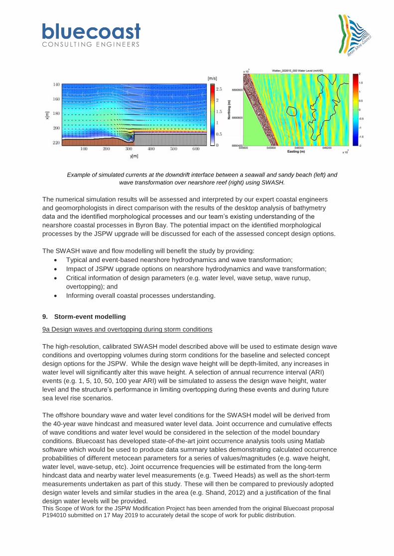
For example, we have carefully selected SWASH and XBEACH as appropriate numerical
modelling tools that are well suited to the key questions around alignment. These detailed
models are able to resolve the small scale differences between alignment options as well as
cover embayment wide considerations. The application of these models will be enhanced by
the targeted field data collection we have included.
Bluecoast are experts at developing the right solution for complex coastal problems. This is
demonstrated by our work on the Palm Beach Shoreline Project and the Beresford Coastal
Protection Scheme, undertaken by us while with our former employer.
Getting the story right: The design solution needs to be bespoke and reflect the informal
nature of Byron Bay and the broader Shire. Traditionally an important meeting place for the
Arakwal people of the Bundjalung Nation, Cavanbah, or Byron Bay is much loved for its
natural beauty. The benign subtropical climate encourages outdoor living and the foreshore
area is a focal point for outdoor activities and gatherings. The list of users is eclectic and
extensive and includes whale watchers, runners, dog walkers, drummers, ocean swimmers,
snorkelers and people looking for somewhere to relax and hang out. A design solution for
this area needs to be based on this existing use pattern and the desire to enhance and
protect the area without resorting to a standard urban solution.
This Scope of Work for the JSPW Modification Project has been amended from the original Bluecoast proposal P194010 submitted on 17 May 2019 to accurately detail the scope of work for public distribution.
Structure alignment, terracing and softening characteristics, provision of beach effective
access, including compliant disable access, recreational, beach and surf amenity, visual
amenity and usage and value of existing assets (e.g. pool and car park) are important
considerations.
A strong connection to the Byron Masterplan will benefit the design development and
evaluation processes. Space Studios are a local architect firm that was heavily involved in
the award-winning community engagement process undertaken for the Masterplan.
The Byron community is vocal and strongly resistant to proposals that threaten the informal
feel of the town. The community is keen to give input and feedback on proposals, and is
generous with its time and expertise in doing so, but it is imperative that expressed opinions
shape the result to avoid ‘consultation fatigue'. Our team will benefit from having local
residents with children and a business based in the town who use and observe the foreshore
area on a regular basis. Passive knowledge of the town as well as professional knowledge
will enable us to rapidly obtain effective insight on user groups and use patterns. We have
included community engagement experts Rhelm in our team which will bridge the gap
between stakeholders and the engineering team effectively.
Getting the engineering right: The design solution needs to be well engineered and
buildable. Stable rock sizing, appropriate toe level based on scour level, crest levels and
details, ground conditions, beach access and adaptability are all key consideration for the
JSPW modification works. A practical understanding of the engineering design will be
required during the design development stage and critical to ensure that a wealth of
experience is harnessed to finalise the detailed design.
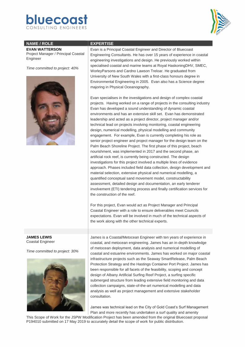
The Bluecoast team of Richard Mocke, Evan Watterson, James Lewis and Heiko Lr has a
wealth of experience in the design of coastal structures along the NSW, QLD and WA
coastlines. To further enhance our coastal engineering and marine structures capabilities we
have teamed with New Zealand based firm Tonkin and Taylor who will support Bluecoast's
coastal engineers with technical input and review so that Council can be sure our
engineering solution will be of the required quality. Tonkin and Taylor’s, Tom Shand has
worked extensively in NSW in his former role at WRL. Our expertise also covers the full
range of project requirements from prefeasibility and conceptual assessments, through to
detailed design (including design optimisation with physical modelling), tendering and
construction supervision.
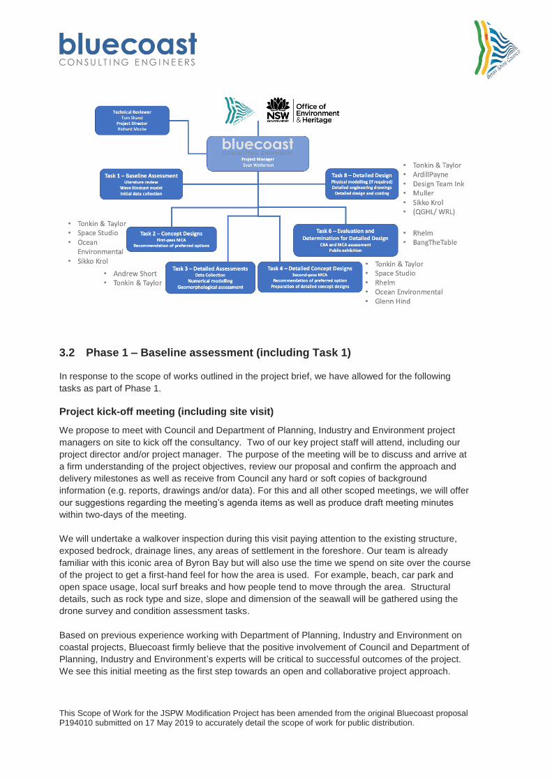
3 METHODOLOGY
3.1 Approach
Bluecoast has developed a suitable approach to meet the requirements set-out in the project brief which is
detailed in the following sections. Our work breakdown structure and input from our sub-consultants for the
JSPW upgrade is shown in the below graph.
This Scope of Work for the JSPW Modification Project has been amended from the original Bluecoast proposal P194010 submitted on 17 May 2019 to accurately detail the scope of work for public distribution.
In response to the scope of works outlined in the project brief, we have allowed for the following
tasks as part of Phase 1.
Project kick-off meeting (including site visit)
We propose to meet with Council and Department of Planning, Industry and Environment project
managers on site to kick off the consultancy. Two of our key project staff will attend, including our
project director and/or project manager. The purpose of the meeting will be to discuss and arrive at
a firm understanding of the project objectives, review our proposal and confirm the approach and
delivery milestones as well as receive from Council any hard or soft copies of background
information (e.g. reports, drawings and/or data). For this and all other scoped meetings, we will offer
our suggestions regarding the meeting’s agenda items as well as produce draft meeting minutes
within two-days of the meeting.
We will undertake a walkover inspection during this visit paying attention to the existing structure,
exposed bedrock, drainage lines, any areas of settlement in the foreshore. Our team is already
familiar with this iconic area of Byron Bay but will also use the time we spend on site over the course
of the project to get a first-hand feel for how the area is used. For example, beach, car park and
open space usage, local surf breaks and how people tend to move through the area. Structural
details, such as rock type and size, slope and dimension of the seawall will be gathered using the
drone survey and condition assessment tasks.
Based on previous experience working with Department of Planning, Industry and Environment on
coastal projects, Bluecoast firmly believe that the positive involvement of Council and Department of
Planning, Industry and Environment’s experts will be critical to successful outcomes of the project.
We see this initial meeting as the first step towards an open and collaborative project approach.
This Scope of Work for the JSPW Modification Project has been amended from the original Bluecoast proposal P194010 submitted on 17 May 2019 to accurately detail the scope of work for public distribution.
Project plan and communications
Within two weeks of the project’s kick-off meeting, we will provide a draft project plan that includes:
The work breakdown structure, based on a revised version provided in this proposal,
Delivery schedule showing each of the agreed project milestones, based on a revised
version provided in this proposal..
Structure and format for report and data deliverables. This will include a draft front cover
and table of contents (showing report structure) following the requirements set-out in
Section 5 of the project brief and in Council’s style guide.
Bluecoast’s Quality Assurance Plan for the project.
The project plan will be updated following Council/Department of Planning, Industry and Environment
comments on the draft. The project plan will be referred to in fortnightly project updates that will be
provided by email to the Council project manager to advise on the progress of the project.
Task 1 – Literature review and baseline assessment
We will undertake a comprehensive desktop review of all relevant documents and data. Having
worked on previous projects in the Byron region our team already have a level of familiarity with the
relevant information and data, including those provided with the project brief. We will further update
and re-familiarise ourselves with all relevant reports focusing on the history, values and uses, risks
and opportunities relating to the JSPW under projected climate change impacts into the future out to
the 2100 planning horizon. Our literature review will include the original Byron Bay – Hastings Point
Erosion Study completed by the then Public Works Department (PWD) as NSW’s first
comprehensive costal investigation and management study.
The Byron Bay Town Centre Masterplan has been developed through an extensive, robust and
award-winning community consultation process. It will be important that the design team and design
process is informed by the local voices, idea and values captured in this document. Our
understanding of this important local context will be enhanced through a close collaboration with our
study partner Space Studios, who are based in Byron Bay and acted in a key community
engagement role for the Masterplan project team and are still connected to the Byron Masterplan
Guidance Group.
1a History, design characteristics and structures condition
Our baseline assessment for this element will comprise:
Development of a historical timeline for the JPSW.
Completion of a drone survey to provide a detailed 3D model of the structure in its current
state.
Coastal engineering condition assessment to document the structural features and current
condition of the JPSW.
Given the history of JSPW it will be important develop a timeline which will be referred to throughout
this project. WorleyParsons’s 2014 report provides a historical overview of the various subsections of
the JSPW. Using this information and other sources, we will compile a timeline including details of
construction and maintenance works, storms events and key investigations. This will be summarised
This Scope of Work for the JSPW Modification Project has been amended from the original Bluecoast proposal P194010 submitted on 17 May 2019 to accurately detail the scope of work for public distribution.
and presented visually on maps, in an easy to understand timeline (example provided below) and in
a table where more detail is required.
Coastal structures are often built progressive as unintended consequences of the initial structure affects
neighbour areas. Visual histories, like the map (Emu Point, WA) and timeline (Cocos Keeling Islands) shown
here can be a simple but effective way to illustrate the progressive construction.
Bluecoast will undertake an unmanned aerial system (UAS or drone) survey to obtain a 3D
topographic model of the JPSW and coastline 500m either side of the structure. The survey would be
undertaken using Bluecoast’s DJI Phantom 4 Pro drone and Trimble R8 RTK GNSS to provide
survey grade results for the area at the selected validation site. Bluecoast is fully CASA accredited
and has developed robust safety procedures which will be provided for review and approval prior to
any field data. Enough ground control points (typically 10 or more) would be surveyed using the RTK
to enable accurate geo-referencing of the data into real world coordinates and datum (AHD). In
addition to this, we will compare the data to nearby permanent survey markers, available from
government agencies, for quality control. Flights will be timed to coincide with low tide and mild wave
conditions to maximise survey coverage.
Following the data collection, the drone data will be used to generate a georeferenced, orthomosaic
image (.tif) and an elevation data point cloud of the site (. las and .xyz). The ortho-mosaic is
anticipated to have a resolution of 3cm/pixel based on a flying height of 80m and the resulting point
cloud with a point density of approximately 80points/m3. An additional lower altitude flight will be
made to produce a 1.2cm/pixel point cloud of the JPSW structure. The data is expected to have a
nominal XYZ accuracy of ±7cm. The drone survey data will be combined with Councils existing
survey and used to inform concept design, coastal processes and modelling and structural condition
assessment. An interactive version of the 3D model will be hosted online for use by Council and
Department of Planning, Industry and Environment accessible using web-browser (e.g. Google
Chrome). We will also capture high resolution aerial imagery and video of the survey area taken from
the same orientation to enable qualitative tracking of sediment and stakeholder engagement
activities.
This Scope of Work for the JSPW Modification Project has been amended from the original Bluecoast proposal P194010 submitted on 17 May 2019 to accurately detail the scope of work for public distribution.
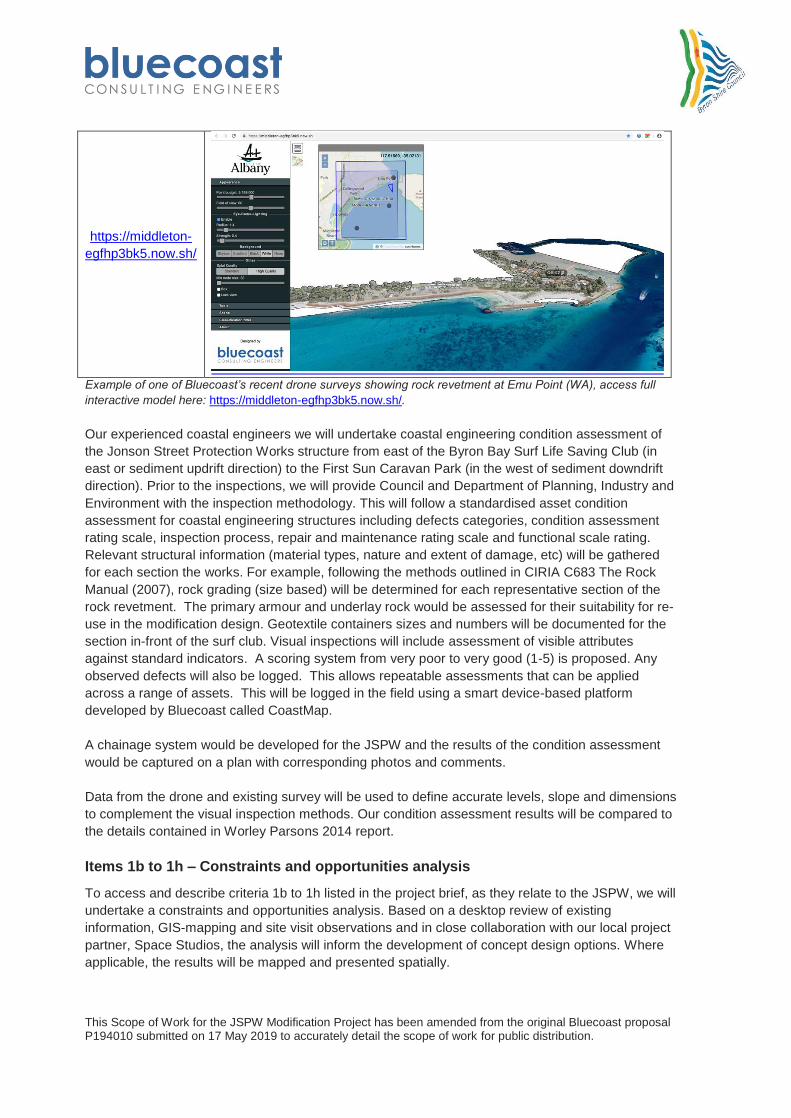
https://middleton-
egfhp3bk5.now.sh/
Example of one of Bluecoast’s recent drone surveys showing rock revetment at Emu Point (WA), access full
interactive model here: https://middleton-egfhp3bk5.now.sh/.
Our experienced coastal engineers we will undertake coastal engineering condition assessment of
the Jonson Street Protection Works structure from east of the Byron Bay Surf Life Saving Club (in
east or sediment updrift direction) to the First Sun Caravan Park (in the west of sediment downdrift
direction). Prior to the inspections, we will provide Council and Department of Planning, Industry and
Environment with the inspection methodology. This will follow a standardised asset condition
assessment for coastal engineering structures including defects categories, condition assessment
rating scale, inspection process, repair and maintenance rating scale and functional scale rating.
Relevant structural information (material types, nature and extent of damage, etc) will be gathered
for each section the works. For example, following the methods outlined in CIRIA C683 The Rock
Manual (2007), rock grading (size based) will be determined for each representative section of the
rock revetment. The primary armour and underlay rock would be assessed for their suitability for re-
use in the modification design. Geotextile containers sizes and numbers will be documented for the
section in-front of the surf club. Visual inspections will include assessment of visible attributes
against standard indicators. A scoring system from very poor to very good (1-5) is proposed. Any
observed defects will also be logged. This allows repeatable assessments that can be applied
across a range of assets. This will be logged in the field using a smart device-based platform
developed by Bluecoast called CoastMap.
A chainage system would be developed for the JSPW and the results of the condition assessment
would be captured on a plan with corresponding photos and comments.
Data from the drone and existing survey will be used to define accurate levels, slope and dimensions
to complement the visual inspection methods. Our condition assessment results will be compared to
the details contained in Worley Parsons 2014 report.
Items 1b to 1h – Constraints and opportunities analysis
To access and describe criteria 1b to 1h listed in the project brief, as they relate to the JSPW, we will
undertake a constraints and opportunities analysis. Based on a desktop review of existing
information, GIS-mapping and site visit observations and in close collaboration with our local project
partner, Space Studios, the analysis will inform the development of concept design options. Where
applicable, the results will be mapped and presented spatially.
This Scope of Work for the JSPW Modification Project has been amended from the original Bluecoast proposal P194010 submitted on 17 May 2019 to accurately detail the scope of work for public distribution.
1b Land ownership and management arrangements at and adjacent to the site
As part of a GIS-based constraints and opportunities analysis we will overly Council’s existing land
ownership mapping layers to determine land ownership across the JSPW and adjacent areas. For
each land tenure identified we will determine if there is a current management arrangement in place
and review each of the associated plans of management. This will be documented using an up-to-
date and project/site specific land tenure map together with a concise summary of land management
arrangements relevant to the JSPW that highlights any implication for the proposed JSPW
modifications. This will be undertaken for land south of the JPSW, seabed areas north of JSPW and
adjacent land either side of the structure.
Our review will be undertaken in collaboration with the Council and Department of Planning, Industry
and Environment and include, but not be limited to:
Much of JSPW is contained within Byron Coast Reserve Trust an area of land classified as
‘Council Managed Crown Reserve’ and is managed by the Byron Coast Reserve Trust
with the Crown as the landowner. Byron Bay Shire manages the trust. There is no plan of
management in place, but the Crown Land Management Act 2016 is applicable.
Cape Byron Marine Park which covers all areas below mean high tide. The Cape Byron
Marine Park Zoning Plan and the Cape Byron Marine Park Operational Plan (Marine Park
Authority, 2010) will be reviewed.
Aboriginal land management arrangements will also be reviewed, including the Arakwal
People Native Title Claim, Indigenous Land Use Arrangements (ILUA1 and ILUA2), the
Heads of Agreement and Memorandum of Understanding between Byron Shire Council
and the Arakwal people
Council’s draft CZMP and CMP Scoping Study will be reviewed including Vision
Statement/s to ensure the coastal management intention are incorporated into the design
of the proposed JPSW modifications.
This Scope of Work for the JSPW Modification Project has been amended from the original Bluecoast proposal P194010 submitted on 17 May 2019 to accurately detail the scope of work for public distribution.
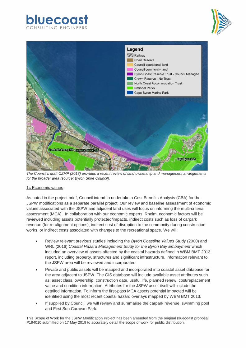
The Council’s draft CZMP (2018) provides a recent review of land ownership and management arrangements
for the broader area (source: Byron Shire Council).
1c Economic values
As noted in the project brief, Council intend to undertake a Cost Benefits Analysis (CBA) for the
JSPW modifications as a separate parallel project. Our review and baseline assessment of economic
values associated with the JSPW and adjacent land uses will focus on informing the multi-criteria
assessment (MCA). In collaboration with our economic experts, Rhelm, economic factors will be
reviewed including assets potentially protected/impacts, indirect costs such as loss of carpark
revenue (for re-alignment options), indirect cost of disruption to the community during construction
works, or indirect costs associated with changes to the recreational space. We will:
Review relevant previous studies including the Byron Coastline Values Study (2000) and
WRL (2016) Coastal Hazard Management Study for the Byron Bay Embayment which
included an overview of assets affected by the coastal hazards defined in WBM BMT 2013
report, including property, structures and significant infrastructure. Information relevant to
the JSPW area will be reviewed and incorporated.
Private and public assets will be mapped and incorporated into coastal asset database for
the area adjacent to JSPW. The GIS database will include available asset attributes such
value and condition information. Attributes for the JSPW asset itself will include the
detailed information. To inform the first-pass MCA assets potential impacted will be
identified using the most recent coastal hazard overlays mapped by WBM BMT 2013.
If supplied by Council, we will review and summarise the carpark revenue, swimming pool
and First Sun Caravan Park.
This Scope of Work for the JSPW Modification Project has been amended from the original Bluecoast proposal P194010 submitted on 17 May 2019 to accurately detail the scope of work for public distribution.
Literature on the economic value of tourism to the region and town centre will be
summarised.
Relevant outcomes of the Byron Bay Town Centre Masterplan’s economic development
strategy, and sub-strategy 01 (a centre for local opportunity) and sub-strategy 02 (a
diverse lifestyle centre) will be considered.
1d Community and cultural values and uses
In collaboration with Space Studios, we will review the overwhelming community feedback from the
Masterplan process on the community’s values for this area. We understand that one of the strong
messages for this area was the desire to retain the unique and informal feel to the foreshore area of
Byron Bay town centre (i.e. does not have a ‘formula’ for foreshore reserves like other areas like the
Gold Coast and Noosa). We will summarise constraints and opportunities associated with:
Community use of assets like the Memorial Pool, car park, surf club and the foreshore
reserve as a meeting and hang-out place.
Cultural values and use of the area for public art, events and impromptu performances.
Visual amenity and aesthetics of the area as captured in the Byron Masterplan and the
desire for a natural and softened appeal. Constraints on levels to avoid a reduction in views
and the trade-off this places on public safety.
Amenity value for beach and surfing recreational activities as well as how people move
through the area.
Other priorities outlined in the Masterplan including Indigenous values and tourism.
Bluecoast plan on taking a hands-on approach to the project and will spend significant time on site to
gather data. During this time, we hope to develop our own appreciation of the community and
cultural values of the area. This was our approach adopted for a recent project on Cocos (Keeling)
Islands, where time on-site talking to locals gave valuable insight to the communities and cultural
values of these unique islands.
1e Environmental values associated with JSPW and adjacent site
A review of the environmental values (marine and terrestrial) of the JSPW site would be undertaken
and summary of environmental values documented. The review of environmental values is
considered to require the following information:
Mapping of vegetation, seagrass, wetlands, marine protected area and other habitat and sensitivity
environmental receptors would be presented to illustrate project constraints. Our desktop review will
be undertaken by Katie Smythe, who has previously (2012) undertaken field surveys and reported on
marine impacts related to the Byron Bay Erosion Works. It will cover:
Marine Habitats - Background data relating to marine habitats in the study area would be
reviewed. This may include information regarding the Byron Bay Marine Park.
Aquatic Vegetation – including mangroves, seagrass and macroalgae in NSW is protected
and cannot be disturbed or harmed without a permit from NSW DPI (Fisheries). NSW DPI
has mapped aquatic vegetation in all NSW estuaries, however, these maps typically do not
extend into coastal/oceanic areas. The estuarine vegetation map for the local area would be
reviewed and any usable data included.
This Scope of Work for the JSPW Modification Project has been amended from the original Bluecoast proposal P194010 submitted on 17 May 2019 to accurately detail the scope of work for public distribution.
Waterway and Fish Habitat Classification (NSW DPI) - The Fisheries NSW Policy and
Guidelines for Fish Habitat Conservation and Management (NSW DPI 2013) would be
referred to and classification of the local marine habitats made in accordance with Table 1
and 2 of the Policy. This is expected to be required by NSW DPI who will assume that all
works are undertaken in accordance with the Policy. Noting this, in accordance with the
Policy, DPI would typically expect a site inspection to be undertaken.
Previous Field Survey Results – A review of the field survey results in the WorleyParsons
(2012) Marine Habitat Survey and Impact Assessment for the Byron Bay Erosion Works
would be made and summarised in the background review.
Marine Protected Areas – the Byron Protected areas, which are set aside for conservation
under the National Parks and Wildlife Act 1974, are managed by the National Parks and
Wildlife Service (NPWS). An important component of the State's reserve system are marine
protected areas.
Matters of National Environmental Significance
SEPP 14 Wetlands and Nationally Important Wetlands
Land Identified as Critical Habitat – Any land declared as Critical Habitat located within the
study area as listed under the Fisheries Management Act 1994, former Threatened Species
Conservation Act 1995 (repealed by the Biodiversity Conservation Act 2016) and EPBC Act
1999 would be made. This would include marine and terrestrial land.
Areas of Outstanding Biodiversity Value (AOBV) – AOBVs in the study area as declared
under Biodiversity Conservation Act 2016 would be identified. This would include marine and
terrestrial land.
Threatened and Protected Marine Fauna
Existing Terrestrial Environment and Values including terrestrial habitats based on
background data and any relevant information which can be provided by Council.
1f Coastal processes and hazards in the Byron Bay embayment
Existing coastal processes and hazard studies in the Byron Bay embayment will be reviewed. The
most relevant and up-to-date mapping related to coastal erosion, shoreline recession, wave
overtopping and coastal inundation, both for present-day and for climate change futures, will be
extracted and mapped as part of the constraint and opportunities analysis. Byron Shire Coastline
Hazard Assessment Update (WBM BMT 2013) provides the latest coastline hazard assessment and
includes ‘best estimate’, ‘minimum’ and ‘maximum’ hazard lines for two erosion scenarios (i.e.
retention of all coastal protection structures or JSPW only). This report also provides sediment
budgets for the embayment along with storm bite extents, metocean regime (wave climate and
design wave heights, water levels etc.), and wave overtopping rates of shoreline recession estimates
relevant to JSPW.
While our focus will be on the JPSW, the coastal processes assessment must consider the entire
sediment compartment of the Byron Bay embayment. Alongside the incorporation of the 2013 hazard
study, a comprehensive review of previous studies would be undertaken. In addition to the reports
listed in the project brief, some highlighted previous study including:
Byron Bay - Hastings Erosion Study (Gordon et. al., 1978)
Scoping study for the Feasibility to Access the Cape Byron Sand Lobe for Sand Extraction
for Beach Nourishment (PBP, 2006)
This Scope of Work for the JSPW Modification Project has been amended from the original Bluecoast proposal P194010 submitted on 17 May 2019 to accurately detail the scope of work for public distribution.
Design of Interim Beach Access Stabilisation Works – Belongil, Byron Bay (WRL, 2013)
It will be important to recognise the synergies with the Coastal Management Program (CMP), as well
as integrate any relevant outcomes from the CMP if the two projects progress in parallel. This will
ensure a consistent approach to coastal management, embayment wide. Council are currently
undertaking a scoping study for the CMP and when available we would review this report.
The NSW Government categorises Belongil Beach as one of 15 coastal erosion ‘hot spots’ and
significant previous work has been completed on coastal processes and hazards. The potential long-
term impacts of a modification to the JSPW needs to be viewed in context with the overall
management of the coast. Key concerns relevant to JSPW were:
Alignment of the coastal protection works within the Byron Bay embayment to avoid the
possibility of creating an artificial headland situation. The need for an overall alignment for
any protection works was put forward to ensure the coastline is managed in a coordinated
and consistent way.
Structure footprint and possible impact of structures or parts of structures (i.e. toe apron)
placed directly on the beach and reduced amenity.
Modular design of beach access and the development of safety management plans to
reduce potential public safety when the beach and structure crest are deemed unsafe.
Avoiding the creation of mini-rips embayment as these can present public safety concerns
for swimmer and surfers and have beach process directly inshore of the rip.
Environmental and social factors as well as long term maintenance issues and plans.
In order to include the most up-to-date observations in the assessment of coastal processes and
hazards, we have also allowed for an analysis of contemporary coastal monitoring data including but
not limited to photogrammetry, aerial photography (sourced from Nearmaps), bathymetric data (e.g.
recent LADS data collected by Department of Planning, Industry and Environment), tidal gauge data
and Byron Bay Waverider buoy. A detailed geomorphological assessment is further described in
Task 3.
IPCC’s AR5 and the relevant Global Climate Models will be used to supplement the available
information on climate change and sea level rise. We appreciate the uncertainties around the local
sea level rise predictions and will include these in our analysis to determine each asset’s
vulnerability.
1g Current and future risks including public safety, projected climate change impacts,
The baseline constraints and opportunities analysis will consider:
Assets potentially impacted will be identified using the most recent coastal hazard overlays
mapped by WBM BMT 2013. This will provide an overview and baseline understanding of
the level of risks to coastal assets.
The NSW Coastal Panel have previous raised public safety in relation to beach access over
rock revetments in the Byron Bay embayment. Public safety risks associated with
pedestrians on rock revetments, access via stairs and access via ramps will be considered.
This Scope of Work for the JSPW Modification Project has been amended from the original Bluecoast proposal P194010 submitted on 17 May 2019 to accurately detail the scope of work for public distribution.
The risk to public safety from overtopping during large waves events with high water levels
under will increase from its current level into the and future due to projected sea level rise.
The baseline assessment will include a review of previous estimates or overtopping rates at
JSPW, such as those presented in Worley Parsons 2014 and WBM BMT 2013.
A review of aerial photograph indicates mini rips can be associated with the JSPW, these
can have implications for swimmer and surfer safety.
1h Opportunities associated with the modification of the JSPW
By reviewing each of the individual criteria, along with the Masterplan, opportunities will be identified
and documented to inform options development. This will be guided by the six project objectives
Specific examples include:
Opportunities to improve beach and surf amenity, public access, foreshore space as well as
public safety.
Opportunities to mitigate the JSPW impacts on coastal processes as well as reduce the
level of risk from current and future coastal hazards.
Drone and other survey data along with conditions assessment results will be used to inform
an upfront assessment of the potential to reuse the existing rock in the structure.
1h Geotechnical conditions
We would request Council’s assistance to obtain any existing reports and data on previous
geotechnical investigations undertaken in the vicinity of JSPW. Knowledge of ground conditions are
important to reduce design risks for coastal structure. Key requirements including the depth of
erodible material at the structure toe, slope stability and foundations for the structure and/or pilling.
We would review broad scale geology as well as all existing information provided by Council, to
summarise available information, identify any potential underlying geotechnical problems and identify
gaps in the geotechnical information required for design.
1i Wave hindcast
A spectral wave model (SWAN by Deltares) will be employed to transform offshore global wave
model data (Wavewatch III) to generate a ~40-year hindcast of local nearshore wave conditions.
While the design wave conditions at the JSPW are likely to be depth-limited (i.e. the maximum wave
heights are limited by the water depth in front of the structures) a high-resolution wave hindcast will
improve the understanding of the local wave and hydrodynamic processes. This will be essential to
not only infer the interaction of the current and proposed structures with the nearshore wave and
hydrodynamic processes but also to provide an understanding of long-term wave statistics and
variety of characteristic conditions. This understanding will ensure that the proposed concept options
can be optimised to minimise any potential negative amenity impacts (e.g. beach width, surfing
quality) at an early stage of this project (i.e. prior to detailed modelling of concept options).
Validation of the nearshore wave hindcast will be undertaken using the Byron Bay Wave Buoy data,
any existing nearshore wave measurements, as well as the proposed wave measurements as part of
this project (see Task 3).
This Scope of Work for the JSPW Modification Project has been amended from the original Bluecoast proposal P194010 submitted on 17 May 2019 to accurately detail the scope of work for public distribution.
3.3 Phase 2 – Concept designs
Task 2 – Identify concept designs
The objective of this task will be to determine a set of suitable preliminary concept design options
that meet the six project objectives and provide a range of viable design solutions to the proposed
JSPW modifications. In response to the project brief our approach is outlined below
1. Liaise with Council during the develop a preliminary Basis of Design
As is our standard practice, we propose to complete a preliminary Basis of Design (BOD) in the form
of a concise technical note or memorandum. The document would outline key features and
assumptions that underpin the design development for the modification to JSPW, including the
design standards, design life, planning horizons, design parameters based on site conditions,
maintenance requirements, extents of the structure and the like. We would liaise with Council and
Department of Planning, Industry and Environment during the development of preliminary Basis of
Design and incorporate design guidance. A draft will be presented to Council for review and liaison
and acceptance prior to commencement of design development and documentation. We have
allowed receiving one set of Council comments on the draft BOD, following which the technical note
would be finalised.
The preliminary BOD would be based on baseline information obtained from our Task 1 review and
will build information contained in the project brief and design proposal, incorporating baseline
physical assumptions. It would provide an agreed platform between Bluecoast and Council for the
initial stage of the design development but would be further refined as the project progresses with
the final Basis of Design proposed to be
completed as part of Task 5. Key design
parameters in the preliminary BOD, such as local
water depth at the structure toe, design water
conditions at the structure, scour depth, ground
conditions, wave run-up level, etc. would also be
based on existing information and subject to
refinement in Tasks 3, 4 and 5.
In assessing design standard Bluecoast proposes
to follow the coastal hazard risk assessment
recommended by The National Committee of
Coastal and Ocean Engineering of Engineers
Australia (shown to the right). Given the
uncertainties of factors affecting coastal
engineering, particularly regarding the impact of
climate change, the approach that we would adopt
is one of combined risk and sensitivity analysis.
The steps in the procedure are outlined in the
following sections.
Specify the design life or planning horizon
The design life of the JSPW would be governed by
the requirements of Council and other
stakeholders. It is assumed the required service
life includes the provision of future maintenance.
The design would need to recognise that
This Scope of Work for the JSPW Modification Project has been amended from the original Bluecoast proposal P194010 submitted on 17 May 2019 to accurately detail the scope of work for public distribution.
maintenance would be required for sections of the structure into the future.
Examine the consequences of failure
The impact of possible "failure" of the JSPW as a result of a large storm could have both direct and
indirect consequences and would be assessed in terms of primary risk outcomes as issues of cost,
safety, environment, downdrift erosion impacts and damage to public/private infrastructure. An
appropriate damage coefficient for the JSPW would be determined through an extensive literature
review.
Select the design event encounter probability
This quantifies the acceptable risk of "failure" of the facility for the duration of the chosen design life
or planning horizon and would be based on the assessed consequences of failure. Worley Parson
(2014) assessed the existing rock armour to be unstable for wave conditions above 1-year ARI with
a “no damage” criteria using Hudson’s Equation. This risk profile is clearly not acceptable. A 50-
year ARI event is often used for land accessible seawalls where maintenance is relatively. Bluecoast
would utilise the CIRIA Rock Manual 2007, BS 6349-1:2000 (Maritime Structures, Part 1 Code of
practice for general criteria, BSI 07-2000) and AS 4997-2005 (Guidelines for the design of maritime
structures) to advice Council on the selection of the most appropriate design event. However, it is
envisaged that the selection of the design event would be discussed and agreed with Council.
As discussed above the key design parameters for the preliminary BOD would be based on existing
information. Sensitivity analysis to these parameters would be examined to assess the sensitivity of
the design at this initial concept design development stage including uncertainty related to climate
change projections.
2. Investigate various concept design options
Bluecoast will investigate potential concept options by considering each of the criteria listed in the
project brief.
A review of the previously proposed design options will be undertaken in-light of contemporary best
practice and cost-effective coastal protection works. Given the site constraints and opportunities
identified in Task 1, a technical and literature review of a long-list of feasible options will be
considered including different material types, seawall and revetments, groynes, submerged reefs,
artificial headlands, sand by-passing, nourishment, dune rehabilitation and retreat. Each will be
summarised in relation to the six project objectives and justification provided where options are
considered unfeasible or marginally feasible. Bluecoast operates on the building with nature
approach and has considerable experience in applying this philosophy to identifying suitable coastal
management/protection solutions. Where hard engineering structures are required consideration of
incorporating appropriate environmentally friendly elements will be discussed. Adaptive design
measures to accommodate future climate change and sea level rise will be assessed. For example,
if the works were to remain on the current alignment and future shoreline recession due to sea level
rise resulted in reduced natural bypassing of sand, a future adaptation could be the introduction of a
small-scale sand by-passing operation.
The inclusion of options that re-align the JSPW landward will be considered as will options to remove
or reduce in length the existing groynes. As discussed above, the alignment of other structures
proposed within the Byron Bay embayment has raised concerns around creation of a headland effect
and unintended effects on beaches, particularly those downdrift. The existing JSPW is seaward of
the natural alignment of the embayment and future sea level rise and shoreline recession will
increase the protruding distance. In addition to coastal processes, the alignment issue will need to
This Scope of Work for the JSPW Modification Project has been amended from the original Bluecoast proposal P194010 submitted on 17 May 2019 to accurately detail the scope of work for public distribution.
be assessed in the context of the landward assets (car park, pool etc), foreshore usage, beach
amenity, movement of pedestrians, improved public safety, climate change risks and other criteria.
By reducing the headland effect, the removal of the groynes would be expected to have a beneficial
effect on coastal processes. The current arrangement of the groynes appears to have some
influence on the nearshore hydrodynamics and rip formation. Nearby surf breaks may be impacted if
these groynes are removed and would need to be considered in combination with coastal processes,
public access and beach amenity. Selecting the optimal alignment and groyne/no groyne
configuration, and confidently assessing the impact on coastal processes, both local and embayment
wide, will require the numerical detailed modelling that is proposed in Task 3.
The alongshore length will be considered from a cost and benefit perspective. Extension or
upgrading the structure to provide additional protection to the surf club will be a key consideration in
the alongshore extent.
Overtopping performance in large return interval wave events will be considered during design
development. The design development will be informed using the empirical approaches to calculate
overtopping outlined in EurOtop 2nd
Edition (2018). The performance of options regarding stability,
failure modes and damage will also be considered for these extreme events.
The concept design phase would also have regard to:
Improving public access, safety, and amenity across the whole JSPW precinct. With
consideration of two beach accesses either side of the car park and disable access
arrangements on at least one access.
Construction costs will be considered based on the costs of previous projects, material
availability and selection.
Maintenance and whole of asset costs based on the expected longevity of the design
options over a 50-year planning horizon and beyond. Access requirements for equipment to
undertake maintenance on the structure will be considered.
Inclusion of a shower, viewing platform, natural features, terracing and informal seating
associated with the western access
Byron Masterplan
3. Identify and document a suite of preliminary options
We have allowed for up to five distinct options to be developed for the modification of the JSPW. It is
anticipated that one of these design options would comprise a berm type rock revetment seawall,
which we have applied successfully for other projects to provide significant savings in the capital cost
of the works. The creation of a berm at the toe of the seawall (which would only be exposed during
extreme events) allows waves to break on the structures at an earlier stage, which in turn reduces
the wave runup and overtopping experienced at the structure and enables a reduced rock size to be
applied on the sloped face of the seawall than would have otherwise been required without a berm.
An example typical cross-section of a berm type seawall is shown below.
This Scope of Work for the JSPW Modification Project has been amended from the original Bluecoast proposal P194010 submitted on 17 May 2019 to accurately detail the scope of work for public distribution.
For each selected concept we will produce high quality sketches of the concept layouts. Our layouts
will include a plan showing the extent and nature of the works, typical cross sections and conflict
points for further consideration. These layouts will be sent to Council, with a brief accompanying
technical note, for consideration. Following a round of discussions/deliberations with Council and
Department of Planning, Industry and Environment, the proposed layouts will be refined. The layout
will not include design drawings or a technical specification. Drawings would be in A3 format
provided in CAD and pdf files.
Based on the concept design layouts, material take-off quantities would be calculated. Quantities will
be presented in the documentation and used to determine order of magnitude costs.
4. Planning and approvals pathways
For each of the concept designs our study partner Realm will consider the required planning matters
and approvals. Bluecoast staff have experience with obtaining state, federal and commonwealth
approvals and permits for beach nourishment and coastal structures projects and would work with
Rhelm to identify any opportunities and limitations associated with these for each of the designs.
To do this we will include a review of existing local, state and federal approval conditions and
limitations. A flow chart which clearly identifies the required development applications, processes
and timeframes to gain approval for the proposed works will be developed. Consideration will be
given to the relative cost and risk associated with the approvals process for each option. Any gaps
in supporting documentation required for the development applications will be identified and
documented.
5. First pass Multi-Criteria Assessment (MCA)
We propose to undertake the following approach to the first-pass MCA:
a. In collaboration with Council and Department of Planning, Industry and Environment
formulate a range of suitable performance measures, or Key Performance Indicators (KPIs),
associated with each of the project objectives. Each KPI should be formulated to offer a true
assessment of the design options performance in achieving the project objectives.
Consideration should also be given to KPIs that can be assessed using results of the design
investigations (e.g. predictive modelling results) and monitored post-project implementation.
While multiple KPI may be required for each project objective, careful consideration by the
project team would reduce unnecessary overlap. A table would be developed showing the
draft KPI’s assigned to against each project objective (see example below). These KPIs can
This Scope of Work for the JSPW Modification Project has been amended from the original Bluecoast proposal P194010 submitted on 17 May 2019 to accurately detail the scope of work for public distribution.
be used throughout the remaining design development and evaluation stages to objectively
assess performance outcomes.
Example KPI table for the Palm Beach Shoreline Project developed by Bluecoast staff. Here KPI are associated
with Key Result Areas, however, for JSPW project this could be project objective.
b. We will then outline the approach for the first pass MCA, including the methodology for
attributes, scores and weights in a concise technical note for Council’s consideration. In
addition to the project objectives and KPI, the MCA approach would consider the positive
and negative aspects of each concept option having regard to the project criteria discussed
in dot-point 2 above. Our engagement and economics experts would provide input into the
approach to the first pass MCA to ensure that it is set up in a consistent manner with a Cost
Benefit Analysis (CBA). Rhelm would assess the positives and negatives of each preliminary
concept design with regards to:
o Environmental considerations;
o Planning and approvals (see Task 2.4); and
o Economics.
The MCA will be structured to provide a robust and defensible basis for the selection of the
most suitable design options. Equally, this assessment will provide the basis for excluding
any options that will not hold water with stakeholders. The MCA incorporates consideration
of projects interdependencies including costs, geotechnical considerations, public safety,
alignment, crest height, structure length and material type. This would be done using
constraint mapping, where possible. Prior to the workshop, we would liaise with Council to
make any adjustments to the first-pass MCA methodology.
c. A workshop for the first-pass MCA will be arranged with Council and key stakeholders in
which attributes, scores and weights will be deliberated. Bluecoast and Rhelm will work
collaboratively to prepare materials (e.g. presentation, surveys or other handouts) as well as
determine the most suitable workshop agenda. This is envisaged to include:
o discuss and confirm criteria and the proposed MCA methodology including weighting
of key themes
This Scope of Work for the JSPW Modification Project has been amended from the original Bluecoast proposal P194010 submitted on 17 May 2019 to accurately detail the scope of work for public distribution.
o discuss pros and cons of each concept design under each MCA criteria
o complete the MCA scoring of all criteria for each concept design.
Emma, Rhelm’s engagement lead, would facilitate the workshop.
Prepare a draft JSPW Investigation Report
A clear and concise report will be prepared following the requirements laid out in the project brief.
High quality figures (maps, plots and other visualisation) will be used wherever possible. The report
will:
Describe the work completed in Task 1
Describe the modification options assessment process completed to this point, including the
first pass MCA. The report will clearly identify and justify all recommendations in relation to
concept design options to be further considered, including those that should be modelled
during Task 3.
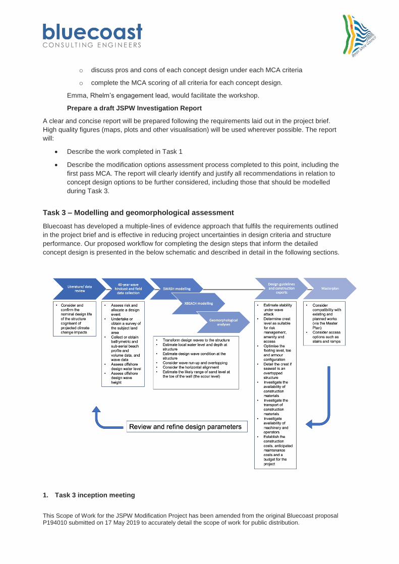
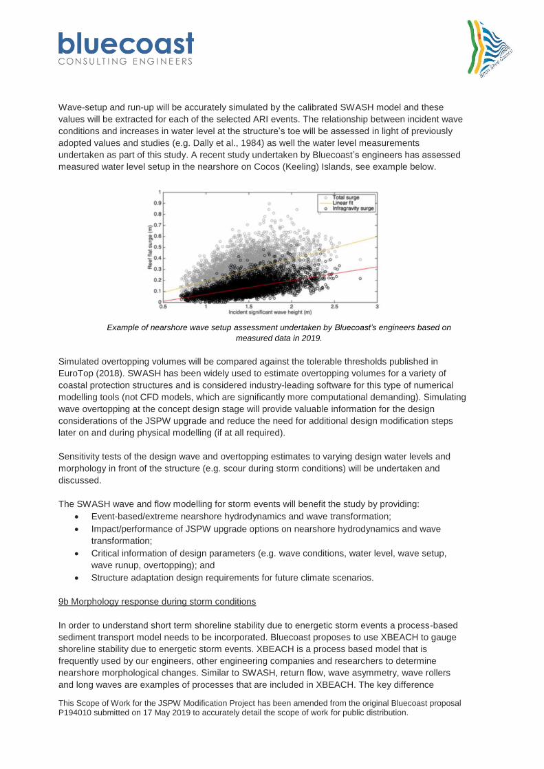
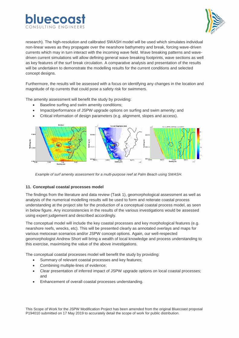
Task 3 – Modelling and geomorphological assessment
Bluecoast has developed a multiple-lines of evidence approach that fulfils the requirements outlined
in the project brief and is effective in reducing project uncertainties in design criteria and structure
performance. Our proposed workflow for completing the design steps that inform the detailed
concept design is presented in the below schematic and described in detail in the following sections.
1. Task 3 inception meeting
This Scope of Work for the JSPW Modification Project has been amended from the original Bluecoast proposal P194010 submitted on 17 May 2019 to accurately detail the scope of work for public distribution.
The Bluecoast project team, including our key coastal engineers and geomorphologist Andrew Short,
will attend a meeting (via telephone or in person) with Council staff and Department of Planning,
Industry and Environment staff to discuss and confirm the concept design scenarios to be included in
the coastal processes modelling, and to discuss and confirm the intended approach to modelling and
proposed input parameters.
2. Local data collection
Bluecoast are strong believers in using measured/observational data to enhance coastal processes
understanding and increase confidence in numerical modelling tools used in parallel. Our engineers
are experts in field data collection and we have access to the latest monitoring technology. As such,
we have included an effective monitoring approach to collect data of key physical parameters that
are required for the design of the JSPW. We have included the data collection as part of Task 3,
however, we suggest some of these tasks be moved into Phase 1 to ensure this data is available
early in the project timeline, this suggestion could be discussed at the project inception meeting.
The key objectives of the monitoring deployments are to collect coastal metocean data which will:
improve the understanding of the metocean conditions contributing to coastal change;
confirm design assumptions and design criteria adopted in previous studies;
support the verification/calibration of numerical models; and
support the design of concept design options.
The data will also benefit concurrent (e.g. coastal hazard definition) and future studies that rely on
the effects of local metocean conditions. The monitoring tasks are described in the following
sections.
Bluecoast recognises the importance of implementing safe work practices, especially when
conducting works in the field. Through working with large clients for complex metocean monitoring
projects we have developed all the required health and safety procedures and policies required for
this project. We have consistently exceeded the health and safety requirements specified by the
clients for the large data collection projects we have recently been involved in. Bluecoast will attain
all necessary permits and approvals including a ‘notice to mariner’ prior to undertaking any
monitoring deployments. A project specific Safe Work Method Statement would be prepared and
provided to Council for review.
Bluecoast believes a robust data management and data processing routine is imperative in ensuring
the accuracy and reliability of the final data set and maximising the data life cycle. In order to ensure
the reliability and integrity of the data collected throughout the project, Bluecoast will make use of
previously developed in-house data management procedures (i.e. Data Management Plan) and data
Quality Assurance (QA) processing tools which maximise high quality data return at reduced labour
intensity. Our engineers have developed a number of QA procedures which are applied to all data
collection works we undertake. A key component of these procedures involves the detailed
screening of all acquired raw data.
3. Nearshore waves and currents
A RBR Virtuoso high-frequency pressure sensor will be deployed for two months in combination with
a Marotte HS current meter on the seabed to measure non-directional waves, water level and near-
bed currents in the immediate nearshore area off the JSPW (in approximately 5-10m water depth).
This is a cost-effective way of collecting the minimum required data to gain the necessary confidence
This Scope of Work for the JSPW Modification Project has been amended from the original Bluecoast proposal P194010 submitted on 17 May 2019 to accurately detail the scope of work for public distribution.
in nearshore process understanding and modelling. We have used this monitoring setup multiple
times where project budgets are tight and deployments need to be kept simple with minimal footprint.
The monitoring data will benefit the study by providing:
An understanding of wave transformation from offshore areas;
Hydrodynamic processes in the nearshore area; and
Validation data for numerical models.
Examples of mooring configuration for the seabed mounted pressure sensor (left) and deployment of a
Marotte HS current meter (right).
4. Measurement of directional waves and currents
Bluecoast will deploy an Acoustic Doppler Current Profiler (ADCP) in the nearshore location instead
of the pressure sensor and current meter for a two month period. We have access to industry-
leading equipment that is able to measure wave heights, periods and directions as well as directional
current speeds at a number of vertical bins throughout the water column (and water level). The
additional parameters collected with this instrument would further improve the coastal process
understanding in the study area as well as provide excellent data to undertake a detailed validation
of the numerical models. The exact location of this monitoring instrument would be strategically
determined through the use of preliminary numerical models and current coastal process
understanding. For example, this could be where uncertainties in processes are evident or key
processes such as rip currents, wave focussing areas are identified that could have implications for
the design of the proposed structures.
We have developed innovative deployment techniques that allow us to deploy our equipment on the
seabed without the use of divers while not compromising data quality. This not only significantly
reduces the safety risk associated with commercial diving, but also considerably reduces deployment
cost. An example of our diver-less and low-profile ‘L-shape’ mooring system is provided in the below
sketch. The durability and low-profile of our mooring and frame configuration, ensured that two
ADCP devices remained intact and unmoved from their shallow water moorings offshore of Mackay
Harbour during the passage of TC Debbie allowing for 100% data capture during the cyclone event
(this data became even more valuable given the Mackay WRB came adrift in this cyclone).
This Scope of Work for the JSPW Modification Project has been amended from the original Bluecoast proposal P194010 submitted on 17 May 2019 to accurately detail the scope of work for public distribution.
Examples of previous Bluecoast ADCP deployments and diver-less ‘L-shape’ mooring system
developed by our engineers
5. Water level at structure toe
A low-profile RBR Solo high-frequency pressure sensor will be deployed to measure water level
variations in front of the existing rock revetment at the Jonson Street car park (at approximately
mean sea level) for a two month period. This real-world laboratory experiment will provide accurate,
measured water level and wave induced setup which form important design parameters for the
proposed structures. This low-profile pressure sensor can be anchored to the seabed or fixed to the
toe of the existing structure (see example below). Having confidence in the design water levels prior
to finalising the concept designs or commencing any physical modelling will significantly reduce
costs associated with design alterations and additional test experiments.
The monitoring data will benefit the study by providing:
An understanding of wave-driven water level variations;
Critical information about design parameters (e.g. wave height, water level, wave run-up,
overtopping); and
Validation data for numerical models.
This Scope of Work for the JSPW Modification Project has been amended from the original Bluecoast proposal P194010 submitted on 17 May 2019 to accurately detail the scope of work for public distribution.
Example of previous deployment of RBR pressure sensor measuring water level and waves atop a
coral reef flat in Cocos (Keeling) Islands
Nearshore bathymetry and beach profiles
6. RTK-GPS and drone survey
Bluecoast proposes a beach transect survey regime be undertaken for the period of the concept
design stage. A simple RTK-GPS (Trimble R8 RTK GNSS) survey will be performed at regular
intervals (50m) tangential to the shore and vegetation lines at (as a minimum) approximately 1km
either side of the JSPW (i.e. Clarkes Beach to Belongil). To ensure seasonal variability is captured
the same transect lines will be repeated at four months intervals and capped to three surveys
commencement of Phase 3 (i.e. 3 x survey dates). If a significant (forecasted) erosion event, these
surveys can be undertaken either side of the erosion event and used for a before/after event
analysis. Should this prove successful, it is recommended that a full-time Council staff member be
trained in this undertaking and repeat the process on a regular basis to create a larger data set for
the future.
An additional drone survey would also be captured using the approach outlined in Task 1. The
repeat data would provide an opportunity to access change between drone surveys.
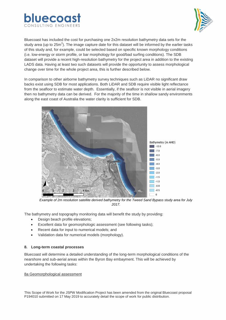
7. Satellite-derived bathymetry (SDB)
With the improvement of spatial coverage, spatial resolution and temporal resolution of satellite data
over the last decade, the use of such data for environmental and coastal engineering purposes has
become very attractive. Our remote sensing specialist partner has developed algorithms that allow
converting satellite imagery into accurate nearshore bathymetry up to approximately 20m water
depth. Our engineers are at the forefront of applying this technology in the coastal engineering and
management space, see (LDepartment of Planning, Industry and Environmentr et al., 2018 and
LDepartment of Planning, Industry and Environmentr et al., 2019). This includes the completion of
detailed validation studies in northern NSW and south-east Queensland that highlighted typical
vertical errors are around 0.3m. The nearshore area at Byron Bay is particularly suitable for the
acquisition of SDB due to the shallow coastal profiles, predominantly sand bottom and clear water.
The key advantages of using this remote sensing data are its cost-effectiveness, readily available
10-years historic database, up to weekly 2x2m resolution images available suitable for high-
resolution bathymetry conversion. Furthermore, the 2x2m gridded data is capable of accurately
describing nearshore morphological features (e.g. sand bars) in both cross-shore and along-shore
directions (i.e. no interpolation between survey transects).
This Scope of Work for the JSPW Modification Project has been amended from the original Bluecoast proposal P194010 submitted on 17 May 2019 to accurately detail the scope of work for public distribution.
Bluecoast has included the cost for purchasing one 2x2m resolution bathymetry data sets for the
study area (up to 25m2). The image capture date for this dataset will be informed by the earlier tasks
of this study and, for example, could be selected based on specific known morphology conditions
(i.e. low-energy or storm profile, or bar morphology for good/bad surfing conditions). The SDB
dataset will provide a recent high-resolution bathymetry for the project area in addition to the existing
LADS data. Having at least two such datasets will provide the opportunity to assess morphological
change over time for the whole project area, this is further described below.
In comparison to other airborne bathymetry survey techniques such as LiDAR no significant draw
backs exist using SDB for most applications. Both LiDAR and SDB require visible light reflectance
from the seafloor to estimate water depth. Essentially, if the seafloor is not visible in aerial imagery
then no bathymetry data can be derived. For the majority of the time in shallow sandy environments
along the east coast of Australia the water clarity is sufficient for SDB.
Example of 2m resolution satellite derived bathymetry for the Tweed Sand Bypass study area for July
2017.
The bathymetry and topography monitoring data will benefit the study by providing:
Design beach profile elevations;
Excellent data for geomorphologic assessment (see following tasks);
Recent data for input to numerical models; and
Validation data for numerical models (morphology).
8. Long-term coastal processes
Bluecoast will determine a detailed understanding of the long-term morphological conditions of the
nearshore and sub-aerial areas within the Byron Bay embayment. This will be achieved by
undertaking the following tasks:
8a Geomorphological assessment
This Scope of Work for the JSPW Modification Project has been amended from the original Bluecoast proposal P194010 submitted on 17 May 2019 to accurately detail the scope of work for public distribution.
A detailed analysis of nearshore bathymetry and topography as well as shoreline position will be
undertaken based on the existing information and data as well as monitoring data collected by
Bluecoast for this study and geomorphological tools, including (but not limited to):
Photogrammetry dating from 1947
Lidar and LADS data
Subtidal bathymetric survey data (existing)
Bluecoast satellite derived bathymetry (one date, see example below)
Bluecoast topographic survey data (drone + beach profiles)
Coastal imaging (Coastalwatch Main Beach camera)
Aerial imagery (e.g. Nearmap)
Other existing data or previous/concurrent studies (e.g. BMT WBM, 2013)
Crenulate Bay empirical geomorphological tool (Hsu et al., 1989)
Our engineers are experts in the analysis of spatial data to infer sediment processes using GIS and
Matlab software. Having completed numerous similar analyses, for example, along the Tweed Sand
Bypassing study area, other Gold Coast Beaches, NSW embayment’s and river entrances and within
Queensland port areas, we have an in-depth knowledge of interpreting long term coastal sediment
processes as well as event based coastal response along the east coast of Australia. We will
undertake volumetric change analyses as well as profile comparisons between survey dates and
describe the key morphological features and their evolution over time. This will include presentation
of annotated spatial difference maps as well as beach profile plots and statistical descriptors.
Bringing a well-respected geomorphologist, Andrew Short, on our project team will maximise the
value this analysis.
In addition, we will apply an empirical geomorphological tool ‘Crenulate Bay’ by Hsu et al. (1989)
which our engineers have applied on similar previous studies to estimate the stable crenulate bay
shape based on the existing environment. Crenulate Bays represent the balancing of the natural
processes of wave action and sediment load on the shoreline. The empirical approach requires the
diffraction point and the dominant wave direction to be known, once these are known it is possible to
determine the equilibrium crenulate bay shape for suitable existing beaches. As such, this approach
can be used to determine the optimum layout for existing and future structures, helping to achieve
the optimum beach shape with minimal sediment loss.
The geomorphologic analysis will benefit the study by providing:
High-level processes understanding of Byron Bay compartment;
Long-term and event-based sediment transport and transport volumes;
Seasonal effects on morphological conditions;
Critical information of design parameters; and
Informing numerical modelling investigations.
This Scope of Work for the JSPW Modification Project has been amended from the original Bluecoast proposal P194010 submitted on 17 May 2019 to accurately detail the scope of work for public distribution.
Example of applying the crenulate bay empirical geomorphological tool by Hsu et al. (1989) to find the
theoretical optimal, stable beach alignment in Beresford, WA.
Examples of long-term bathymetric change analyses between two satellite derived bathymetry ‘survey’
dates at the Tweed Sand Bypassing study area.
CBM01
Beach
Transect
1year ARI storm bite
This Scope of Work for the JSPW Modification Project has been amended from the original Bluecoast proposal P194010 submitted on 17 May 2019 to accurately detail the scope of work for public distribution.
Examples of topography change analyses between two drone survey dates before and after an
extreme erosion event at Cocos (Keeling) Island.
Example of previous analysis of coastal imaging beach width statistics along Palm Beach for the period
from 2004 to 2017.
8b SWASH modelling of typical conditions
Based on the metocean data review and ~40-year wave hindcast undertaken as part Task 1, three
representative periods associated with low-energy, medium-energy and high-energy metocean
conditions will be simulated using a phase-resolving hydrodynamic and wave model (i.e. individual
waves are being resolved). This will be undertaken using the state-of-the-art numerical model
SWASH developed by Deltares for a model domain stretching from The Pass to Belongil Beach.
SWASH is a nonlinear shallow water wave and hydrodynamic model which accounts for wave-
breaking, non-linear wave transformation (e.g. wave focussing over nearshore reefs), interaction with
structures and can accurately estimate wave-induced water level setup. A detailed calibration and
validation exercise will be undertaken using the measured nearshore currents and wave data (see
above) and wave setup measurements at the structure’s toe (see above). This will ensure the model
results can be trusted and significantly reduce uncertainties in the predictions, hence reducing the
project risk.
This model is the best tool for assessing the baseline conditions and impacts of the selected concept
designs on the nearshore wave and hydrodynamic processes at JSPW. This high-resolution model
(proposed 2m by 2m spatial resolution near the structures) will be able to predict any downdrift or
updrift impacts caused by the structures under current and future climatic conditions (e.g. sea level
rise, increased storminess). An example of simulating the downdrift impacts of the seawall on a
sandy beach using SWASH is provided in the figure below.
This Scope of Work for the JSPW Modification Project has been amended from the original Bluecoast proposal P194010 submitted on 17 May 2019 to accurately detail the scope of work for public distribution.
Example of simulated currents at the downdrift interface between a seawall and sandy beach (left) and
wave transformation over nearshore reef (right) using SWASH.
The numerical simulation results will be assessed and interpreted by our expert coastal engineers
and geomorphologists in direct comparison with the results of the desktop analysis of bathymetry
data and the identified morphological processes and our team’s existing understanding of the
nearshore coastal processes in Byron Bay. The potential impact on the identified morphological
processes by the JSPW upgrade will be discussed for each of the assessed concept design options.
The SWASH wave and flow modelling will benefit the study by providing:
Typical and event-based nearshore hydrodynamics and wave transformation;
Impact of JSPW upgrade options on nearshore hydrodynamics and wave transformation;
Critical information of design parameters (e.g. water level, wave setup, wave runup,
9a Design waves and overtopping during storm conditions
The high-resolution, calibrated SWASH model described above will be used to estimate design wave
conditions and overtopping volumes during storm conditions for the baseline and selected concept
design options for the JSPW. While the design wave height will be depth-limited, any increases in
water level will significantly alter this wave height. A selection of annual recurrence interval (ARI)
events (e.g. 1, 5, 10, 50, 100 year ARI) will be simulated to assess the design wave height, water
level and the structure’s performance in limiting overtopping during these events and during future
sea level rise scenarios.
The offshore boundary wave and water level conditions for the SWASH model will be derived from
the 40-year wave hindcast and measured water level data. Joint occurrence and cumulative effects
of wave conditions and water level would be considered in the selection of the model boundary
conditions. Bluecoast has developed state-of-the-art joint occurrence analysis tools using Matlab
software which would be used to produce data summary tables demonstrating calculated occurrence
probabilities of different metocean parameters for a series of values/magnitudes (e.g. wave height,
water level, wave-setup, etc). Joint occurrence frequencies will be estimated from the long-term
hindcast data and nearby water level measurements (e.g. Tweed Heads) as well as the short-term
measurements undertaken as part of this study. These will then be compared to previously adopted
design water levels and similar studies in the area (e.g. Shand, 2012) and a justification of the final
design water levels will be provided.
This Scope of Work for the JSPW Modification Project has been amended from the original Bluecoast proposal P194010 submitted on 17 May 2019 to accurately detail the scope of work for public distribution.
Wave-setup and run-up will be accurately simulated by the calibrated SWASH model and these
values will be extracted for each of the selected ARI events. The relationship between incident wave
conditions and increases in water level at the structure’s toe will be assessed in light of previously
adopted values and studies (e.g. Dally et al., 1984) as well the water level measurements
undertaken as part of this study. A recent study undertaken by Bluecoast’s engineers has assessed
measured water level setup in the nearshore on Cocos (Keeling) Islands, see example below.
Example of nearshore wave setup assessment undertaken by Bluecoast’s engineers based on
measured data in 2019.
Simulated overtopping volumes will be compared against the tolerable thresholds published in
EuroTop (2018). SWASH has been widely used to estimate overtopping volumes for a variety of
coastal protection structures and is considered industry-leading software for this type of numerical
modelling tools (not CFD models, which are significantly more computational demanding). Simulating
wave overtopping at the concept design stage will provide valuable information for the design
considerations of the JSPW upgrade and reduce the need for additional design modification steps
later on and during physical modelling (if at all required).
Sensitivity tests of the design wave and overtopping estimates to varying design water levels and
morphology in front of the structure (e.g. scour during storm conditions) will be undertaken and
discussed.
The SWASH wave and flow modelling for storm events will benefit the study by providing:
Event-based/extreme nearshore hydrodynamics and wave transformation;
Impact/performance of JSPW upgrade options on nearshore hydrodynamics and wave
transformation;
Critical information of design parameters (e.g. wave conditions, water level, wave setup,
wave runup, overtopping); and
Structure adaptation design requirements for future climate scenarios.
9b Morphology response during storm conditions
In order to understand short term shoreline stability due to energetic storm events a process-based
sediment transport model needs to be incorporated. Bluecoast proposes to use XBEACH to gauge
shoreline stability due to energetic storm events. XBEACH is a process based model that is
frequently used by our engineers, other engineering companies and researchers to determine
nearshore morphological changes. Similar to SWASH, return flow, wave asymmetry, wave rollers
and long waves are examples of processes that are included in XBEACH. The key difference
This Scope of Work for the JSPW Modification Project has been amended from the original Bluecoast proposal P194010 submitted on 17 May 2019 to accurately detail the scope of work for public distribution.
between SWASH and XBEACH being that the latter is able to predict morphology changes including
shoreline position and, in particular, sub-aqueous and sub-aerial profile erosion. Because of the
inclusion of long waves (infra gravity waves) XBEACH is specifically suitable for models in the
nearshore zone, where phase-averaged models such as DHI’s MIKE 21 SW/ST or Delft3D are often
used for larger domains and deeper areas. XBEACH was initially designed to determine the coastal
erosion during storms (Roelvink et al., 2009) and (Roelvink et al., 2015).
Shoreline response to the selected ARI offshore wave and water level conditions (as determined in
previous task) will be simulated using a 2D non-hydrostatic XBEACH model for the baseline and
selected concept design options. This will predict morphology changes in front of the structures
(including scour at the structure’s toe) as well as in unprotected updrift and downdrift areas (i.e. from
The Pass to Belongil Beach) and sediment bypassing at the JSPW. It is proposed that the XBEACH
model be calibrated to the measured nearshore wave and currents as well as water levels at the
structure’s toe to ensure wave setup during these events is correctly resolved.
XBEACH cross-shore sediment transport predictions would be calibrated to any measured storm
bites (or the amount of beach erosion caused by storms) captured in the topographic measurements
undertaken as part of this study. Simulated storm bites for each of the ARI events will be tabulated
for the baseline and selected concept design options.
The XBEACH morphology modelling for storm events will benefit the study by providing:
Event-based/extreme nearshore morphology;
Impact/performance of JSPW upgrade options on nearshore morphology; and
Critical information of design parameters (e.g. design profile, scour depth, toe configuration).
Examples of SWASH overtopping (left) and XBEACH morphology (right) simulation results during
storm conditions.
10. Amenity assessment
To understand the impact of the JSPW upgrade on the surrounding surf breaks and swimming areas
(i.e. between Main Beach and The Wreck), a baseline characterisation of the existing wave
mechanics will be undertaken first considering effects of bathymetry, incident wave conditions
(height, period, direction) and water levels. This approach will then be reproduced for post-JSPW
upgrade conditions (i.e. structures, alignment and inferred/modelled bathymetry) to evaluate relative
changes in incident and reflected wave energy and wave breaking positions and potential effects on
the wave quality and swimmer’s safety.
Surf specific metocean conditions will be derived from the ~40-year wave hindcast and known ‘good
surfing’ conditions (to be determined in consultation with the local surfing community or social media
This Scope of Work for the JSPW Modification Project has been amended from the original Bluecoast proposal P194010 submitted on 17 May 2019 to accurately detail the scope of work for public distribution.
research). The high-resolution and calibrated SWASH model will be used which simulates individual
non-linear waves as they propagate over the nearshore bathymetry and break, forcing wave-driven
currents which may in turn interact with the incoming wave field. Wave breaking patterns and wave-
driven current simulations will allow defining general wave breaking footprints, wave sections as well
as key features of the surf break circulation. A comparative analysis and presentation of the results
will be undertaken to demonstrate the modelling results for the current conditions and selected
concept designs.
Furthermore, the results will be assessed with a focus on identifying any changes in the location and
magnitude of rip currents that could pose a safety risk for swimmers.
The amenity assessment will benefit the study by providing:
Baseline surfing and swim amenity conditions;
Impact/performance of JSPW upgrade options on surfing and swim amenity; and
Critical information of design parameters (e.g. alignment, slopes and access).
Example of surf amenity assessment for a multi-purpose reef at Palm Beach using SWASH.
11. Conceptual coastal processes model
The findings from the literature and data review (Task 1), geomorphological assessment as well as
analysis of the numerical modelling results will be used to form and reiterate coastal process
understanding at the project site for the production of a conceptual coastal process model, as seen
in below figure. Any inconsistencies in the results of the various investigations would be assessed
using expert judgement and described accordingly.
The conceptual model will include the key coastal processes and key morphological features (e.g.
nearshore reefs, wrecks, etc). This will be presented clearly as annotated overlays and maps for
various metocean scenarios and/or JSPW concept options. Again, our well-respected
geomorphologist Andrew Short will bring a wealth of local knowledge and process understanding to
this exercise, maximising the value of the above investigations.
The conceptual coastal processes model will benefit the study by providing:
Summary of relevant coastal processes and key features;
Combining multiple-lines of evidence;
Clear presentation of inferred impact of JSPW upgrade options on local coastal processes;
and
Enhancement of overall coastal processes understanding.
This Scope of Work for the JSPW Modification Project has been amended from the original Bluecoast proposal P194010 submitted on 17 May 2019 to accurately detail the scope of work for public distribution.
12. Task 3 Deliverables
The methodology and results of the modelling and geomorphological assessments will be described
and issued to Council in the draft report (Issue #2). This will include the predicted impacts to coastal
processes associated with each concept option in form of a clear discussion and visualised on a map
uncertainties associated with modelling and assessing coastal processes, in particular, sediment
transport and the potential impact on the design/performance of the JSPW upgrade. This will be
discussed critically.
Following receipt of comments from Council (Hold Point #2) we will finalise the draft report (Issue
#2).
Task 4 – Evaluation of concept design and key stakeholder engagement
The key objective of this task is to provide a comprehensive and transparent evaluation of the
concept designs for the modification of the JSPW. This will be completed using a second-pass
multicriteria assessment as the guiding framework. A significant body of work will have been
completed in Tasks 1 to 3 and this will be incorporated into the evaluation processes.
13. Co-design the second-pass MCA methodology with Council
We will work in close collaboration with Council to co-design the second-pass MCA methodology.
We proposed to meet with Council’s project team at the outset of this phase to review the positives
and negatives of the first-pass MCA, discuss possible refinements to the projects draft KPIs, assess
any gaps in the assessment criteria and discuss the strategy, stakeholders and methodology for the
next pass.
Following this initial meeting, we will undertake further work to comprehensively assess each option
against the themes outlined in the project brief as outlined below. This work will be completed by our
second pass MCA project team, including Rhelm (Engagement, Environment and Economics),
Space Studio (local engagement and linkage with Byron Masterplan) and Katie Sythmie (Ecology).
This Scope of Work for the JSPW Modification Project has been amended from the original Bluecoast proposal P194010 submitted on 17 May 2019 to accurately detail the scope of work for public distribution.
This work will be summarised and used
by Council and Bluecoast to complete
the design of the workshops in a
collaborative approach.
a. Community/cultural values
Traditionally an important meeting place
for the Arakwal people of the Bundjalung
Nation, Cavanbah, or Byron Bay is much
loved for its natural beauty. The
subtropical climate encourages locals
and visitors to spend time outdoors and the foreshore area near JSWP is a focal point for outdoor
activities and gatherings. The list of users is eclectic and extensive and includes whale watchers,
surfers, surf and ocean observers, beachgoers, snorkelers and people looking for somewhere to
relax and hang out. A design solution for this area needs to be based on this existing use pattern and
the desire to enhance and protect the area without resorting to a standard urban solution. A bespoke
design reflecting the informal nature of Byron Bay and the broader Shire is likely to gain greater
community support.
Space Studio were involved in the development of the Byron Masterplan and provided a strong
linkage between advice on local community matters. The Masterplan project was structured as a
‘ground up’, and Space Studio were involved in extensive community consultation both online and
face to face. The data gathered from the workshops, information sessions and user group meetings
will be referenced to assist in the evaluation criteria for the assessment of modification options for
JSPW.
Values such as community use of assets (Memorial Pool) adjacent the JSPW, priorities of the Byron
Masterplan which include sensitive integration of the foreshore and works with recreation, nature and
pedestrian movement, Indigenous values, tourism, and surfing amenity will be considered.
b. Public recreational amenity and public safety
Each of the concept design options assessed against recreational amenity and public safety criteria
such as pedestrian safety around rock walls (slippage), alongshore access, safe swimming areas
and beach amenity. Byron Masterplan seeks to create a seamless connection between Apex Park,
Peace Park, Denning Park and Foreshore Park. The movement of people through the foreshore area
will be an important consideration as with the potential for any linkages with the potential upgrade of
the Surf Lifesaving Club. The modification options should seek to strengthen Main Beach’s role as
Byron Bay’s most popular asset.
This Scope of Work for the JSPW Modification Project has been amended from the original Bluecoast proposal P194010 submitted on 17 May 2019 to accurately detail the scope of work for public distribution.
Any works should be aiming to minimise negative impact on surfing amenity and the detailed
modelling completed as part of Task 3 will assist in evaluating any positive or negative impacts on
surf amenity and inform key decisions of the structure’s alignment.
c. Visual amenity and aspect
Based on visual amenity and aspect recommendation and from Space Studio, we will develop
visualisation of each of the concept design options for assessment. These will assist in the
comparative assessment of visual impact of the works on the area, including the view from land
adjacent the JSPW towards the sea, the ranges to the west, and Cape Byron to the east. We will
also work collaboratively with Space Studio to consider each option against the priorities in the Byron
Masterplan.
d. Economic factors
Economic factors will be assessed for each concept design option including construction costs,
maintenance costs, and indirect costs such as loss
of carpark revenue (for re-alignment options),
indirect cost due to the disruption to the community
during construction works, or indirect costs
associated with changes to the recreational space.
e. Ecological impacts of marine and terrestrial
habitats
Ecological impacts on marine and terrestrial habitats
will be assessed and compared for each concept
design option. Factors considered will include loss
or gain of intertidal areas, loss or gain of vegetation,
potential pests associated with rocks (rats and/or
snakes) and degradation of materials into the marine environment.
f. Coastal process, beach profile and planform and surf amenity
The comparative assessment for each of the concept designs will be based on the results of the
modelling and geomorphological assessment completed as part of Task 3. The modelling approach
we have adopted will allow KPIs to be quantitatively assessed and compared across options
including predicted impacts to shoreline alignment, beach profile, sediment transport as well as surf
quality. For the purpose of the second-pass MCA we will present the results in a clear and concise
summary, including any key limitations and uncertainties, and seek feedback and assist in the
evaluation.
f. Climate change and sea level rise
Future climate change scenarios will be modelled for each concept design as part of Task 3. This
modelling and associated analysis as part of the geomorphological assessment will be used to
compare the sensitivity and/or resilience of each concept design option. This assessment will have
regard to climate change impacts including sea level rise, storm intensity increases and changes to
wave climate (including direction). Options with the ability to adapt to withstand predicted future
physical forces will be considered favourably.
This Scope of Work for the JSPW Modification Project has been amended from the original Bluecoast proposal P194010 submitted on 17 May 2019 to accurately detail the scope of work for public distribution.
14. Second-pass MCA workshop
The second-pass MCA will be a critical step in the projects progressing and the positive involvement
of the Council and stakeholders will be critical to successful outcomes for the modifications of the
JSPW. With Rhelm’s assistance, Bluecoast will plan and facilitate each workshop so that all
participants have a clear understanding of the agenda and MCA process. The workshop will aim to
be focused and engaging with the aim of obtaining feedback that will inform the assessment of the
concept designs.
The workshop is anticipated to include engagement with Councillors, Council staff and State agency
representatives and other key stakeholders. Bluecoast will undertake the second-pass MCA in a
workshop style setting to evaluate and score the concept designs against the endorsed criteria and
the project objectives. The workshop attendees are to be confirmed in liaison with Council. The MCA
workshop will be facilitated to provide an opportunity for stakeholders to;
discuss and confirm criteria and the proposed MCA methodology including weighting of key
themes
discuss pros and cons of each concept design under each MCA criteria
complete the MCA scoring of all criteria for each concept design.
15. Update draft report (issue #3)
A clear and concise report will be drafted following the requirements laid out in the project brief. High
quality figures (maps, plots and other visualisation) will be used wherever possible. The report issue
#3 will:
a. Provide a comprehensive discussion on the assessment methodology (including
stakeholder engagement),
b. Provide a comprehensive analysis of the results of the second-pass MCA including
description of key assumptions, key uncertainties, key limitations, and other matters
requiring clarification
c. A full justified technical recommendation of the preferred concept designs that best fulfil
the project objectives will be provided. This option will be suitable for progression to detailed
concept designs in the next phase of the project.
16. Finalise report (issue #3)
Following receipt of a single set of consolidated comments from Council and Council’s technical
reviewer we will update the draft report for issue.
17. Strategic Planning Councillor Workshop
In collaboration with Council’s project team we will present the findings of the Draft Report (Issue #3)
to Byron Shire Councillor’s at a Strategic Planning Councillor Workshop. Our project lead will engage
in discussion to assist Councillors in their deliberations on the recommended concept designs.
18. Strategic Planning Councillor Workshop
This Scope of Work for the JSPW Modification Project has been amended from the original Bluecoast proposal P194010 submitted on 17 May 2019 to accurately detail the scope of work for public distribution.
Following feedback and direction received from Council on the outcomes of the project to this point,
and in accordance with any consolidated feedback from the Strategic Planning Councillor Workshop,
we will finalise and reissue the draft report
3.4 Phase 3 – Detailed concept designs
Task 5 – Prepare detailed concept designs
Bluecoast’s coastal engineers will incorporate the findings from Phase 1 and Phase 2 to update the
basis of design for the optimisation of the three endorsed JSPW modification options. The detailed
concept designs will incorporate the design steps outlined in the Project brief and are informed by
the investigations undertaken in Phase 1 and Phase 2 (see flow chart in Task 3). Further, we have
included architects with an invaluable understanding of the Masterplan as well as construction
experts that will bring value to developing the construction methodology and costs. Our project team
has been involved in all stages of the design of coastal protection options and construction of coastal
protection structures and identified the following key opportunities in the JSPW upgrade:
Byron Bay Masterplan integration
Considerable community engagement and planning of the JSPW area has been undertaken
as part of the development of the Masterplan. To ensure the findings from the Masterplan
are effectively incorporated into the detailed concept design developments, we have
included the Masterplan architects, Space Studio, in our design team. The architects will not
only bring their knowledge of the already completed investigations and planned works in the
surrounding area to this team but also provide design input in optimising the detailed
concept designs in alignment with the Masterplan. Space Studio was engaged on the
Masterplan team as architect and local consultant. Their role was to advise on architectural
matters such as sub-tropical design, materials and building form, local character and the
built environment as well as providing advice on local community matters.
Understanding of risk management and adaptation options
Bluecoast and Tonkin & Taylor coastal engineers appreciate that, other than building hard
engineering structures to withstand the most extreme climatic conditions, there are
opportunities in incorporating risk management and adaptation options. This may provide
considerable benefits in increasing amenity while reducing cost and structure footprint as
well as potential downdrift impacts. Bluecoast are believers in the working with nature
principle through innovative design solutions and detailed understanding of coastal
processes, their interaction with coastal protection structures and associated risks. We will
apply our broad knowledge of such risk management and structure adaptation options to find
the right balance of level of protection, sustainability and cost-effectiveness. Our engineers
have significant experience in ‘soft-engineering’ approaches due to their involvement in the
design of coastal protection options in remote locations with limited material availability and
small island developing countries with limited budgets.
Early construction expert involvement
Early involvement of construction experts or contractors is now used in the industry during
the appraisal and design stage with the benefit of more cost certainty, sustainability and
buildability. Other key benefits of such early involvement are in the mobilisation of both
design and construction skills at a key development stage in the project, with the anticipated
result of an inherently safer and lower risk project. The below figure shows the balancing of
three key construction considerations that need to be addressed in the design of coastal
protection structures. As such, Bluecoast have included Sikko Krol to our design team who is
This Scope of Work for the JSPW Modification Project has been amended from the original Bluecoast proposal P194010 submitted on 17 May 2019 to accurately detail the scope of work for public distribution.
a respected maritime construction expert in Australia. Most recently, Sikko has been
appointed to provide advice during the design development of the Palm Beach Shoreline
Project. Sikko and our coastal engineers have a good understanding of the local
construction industry, available plant and material transport considerations required for the
JSPW. As such, this will ensure an accurate construction cost and anticipated maintenance
cost for each of the three detailed concept design options can be established at this stage.
Construction criteria of the coastal engineering structures
Quarry investigations
Bluecoast has an in-depth knowledge of the quarries in northern NSW and south-east
Queensland. Our engineers have recently undertaken visits to most of the quarries in this
region to find suitable construction materials and adequate volume of larger rock for the
Palm Beach Shoreline Project. For these, we have detailed quarry reports stating yield and
inspection test results. In addition, we have access to a detailed quarry review for this region
undertaken by the City of Gold Coast for the Kirra groyne upgrade. We will use our existing
knowledge of the quarries in this area and experience from similar projects to effectively
provide the information required for the detailed concept design of the JSPW upgrade
options.
Artists impressions and visualisations
Previous coastal design projects, that included significant stakeholder consultation
undertaken by Bluecoast engineers, proved the effectiveness of producing artist impressions
and visualisations for concept design options. As such, we have included 3D designer Glenn
Hind in our team and allowed for two impressions for each concept design option. An
example from previous concept designs is provided below.
Tolerances
Cost Work Method
This Scope of Work for the JSPW Modification Project has been amended from the original Bluecoast proposal P194010 submitted on 17 May 2019 to accurately detail the scope of work for public distribution.
Task 5 Deliverables
As the main deliverable from this task we will update the Draft Report (Issue #4) to describe in clear
terms the design specifications, design rationale, and design limitations for each detailed concept
design.
The issue of the Draft Report will include a full suite of drawings for each detailed concept design
including cross section, plan and elevation views.
Following receipt of Council’s technical review comments (Hold Point #6) we will finalise the Draft
Report (Issue #4) within two weeks.
This Scope of Work for the JSPW Modification Project has been amended from the original Bluecoast proposal P194010 submitted on 17 May 2019 to accurately detail the scope of work for public distribution.
3.5 Phase 4 – Evaluation and determination for detailed design
Task 6 – Evaluate detailed concept design and engage with the broader community
Phase 4 and Task 6 will determine the recommended detailed concept design that best satisfies the
project objectives. The selected detailed concept design will be progressed to Phase 5, which will
include assessment of the requirement for physical modelling.
Assess and consider the results of the completed Cost Benefit Analysis (CBA)
As noted in project brief the CBA will be undertaken as a separate parallel project. Our economist,
Rhys Thomson, would consider the outcomes of the CBA and provide a summary report with regard
to considerations for the CBA and design process (see Task 6.3 below for reporting). Through his
earlier involvement in assessing the economic factors and broader review of the first and second
pass MCA process, Rhys will already be embedded in the project and well placed to assess and
consider the results of the CBA.
1. Assess and consider the results of the second-pass MCA
We will consider and assess the outcomes of the second-pass MCA in-light of the CBA results and
the development and costing undertaken in the detailed concept design task (Task 5).
2. Update the draft report (issue #5)
A clear and concise report will be drafted following the requirements laid out in the project brief. High
quality figures (maps, plots and other visualisation) will be used wherever possible. Our economist,
Rhys Thomson, would provide input to the draft report with regards a. and b. below to: The report
issue #4 will:
a. Summarise the CBA process and outcomes.
b. Undertake a technical comparison between the CBA results and the second pass MCA
results to describe possible reasoning for any differences in the rankings of design options,
the key differences in the two assessments, etc. The technical analysis would include
discussion outlining the Consultant’s opinions and insights on the outcomes of the CBA and
MCA, including on the top ranked options correlation with the project objectives.
c. Identify one, or a maximum of two, detailed concept designs that are recommended to
Council for progression towards ‘detailed design and costing’ with accompanying
justification.
5. Update the draft report (issue #5)
Following feedback received after Hold Point #7, (Task 6.4), we will update and finalise draft report
issue #5.
6. Council’s report to a formal meeting of Council
Bluecoast will provide support, if required, in preparing or responding to endorsement by Council.
7. Public exhibition
This Scope of Work for the JSPW Modification Project has been amended from the original Bluecoast proposal P194010 submitted on 17 May 2019 to accurately detail the scope of work for public distribution.
Our engagement specialist, Emma Maratea, would develop an engagement strategy for the public
exhibition period in accordance with the objectives of the NSW Coastal Management Manual and the
IAP2 framework. The engagement strategy will identify the consultation context, scope,
stakeholders, purpose and goals, engagement methods and evaluation strategies. Emma would
work closely with Council and Department of Planning, Industry and Environment to ensure that the
objectives and goals of the consultation are identified, scoped and evaluated.
From our initial appraisal of the project, the community and the likely issues and questions to be
raised by the community, we have allowed for undertaking the following engagement tasks during
the public exhibition period:
Providing Council with project information for website content (assumed to be hosted on
Council’s website), this would include project details, content and key images and maps. It is
assumed that Council will provide an opportunity on the webpage for the community to
submit comments and feedback.
An information brochure will be prepared by Rhelm and Bluecoast for Council to review and
distribute to the community via mail. This would include project details, information on how to
make a submission, and direct the recipient to the website and drop in information session.
Rhelm would prepare for and facilitate two drop-in information sessions. It is expected that
these sessions would be undertaken on the same day or concurrent days. The format of the
sessions would be discussed with Council. These sessions would be attended by one Rhelm
staff and at least one Bluecoast staff as well as Council’s project manager.
8. Task 6.8 Compile and Respond to Public Exhibition Submissions
Bluecoast and Rhelm would consider the submissions, community feedback and agency comments
received and compile the submissions into a report (or spreadsheet) and would gather responses
from the project team and Council. If individual responses need to be sent to the community, these
will be drafted with input from Bluecoast and provided to Council for review.
We have allowed for an update to the Draft Report to describe the public exhibition activities and
summarise the key issues raised. Responses to key themes will be provided, whereever relevant.
3.6 Phase 5 – Physical modelling requirement
Task 7 – Physical modelling requirement
Bluecoast has extensive experience in the use of physical models to confirm design parameters and
undertaking coastal processes assessments. Our engineers have previously developed physical
modelling methodologies, test programs and undertaken detailed measurements, analysis and
interpretation of the measured parameters. We have an in-depth understanding of the advantages
and limitations that come with physical model tests. Most recently, we have undertaken a multiple-
lines of evidence approach in the design of the Palm Beach submerged control structure using
coastal monitoring, numerical models and physical models. In addition, we have an excellent
professional relationship with two physical modelling laboratories in Australia suitable for the JSPW
upgrade design, i.e. Water Research Laboratory in Manly, NSW and the Queensland Government
Hydraulics Laboratory in Deagon, QLD. However, being an independent engineering consultant firm,
we are in a position to liberally advice Council whether this additional investigation will be required.
This Scope of Work for the JSPW Modification Project has been amended from the original Bluecoast proposal P194010 submitted on 17 May 2019 to accurately detail the scope of work for public distribution.
Example of damage assessment in physical modelling undertaken at QGHL for the Palm Beach
Shoreline Project.
We have designed our approach to develop the detailed concept design options for the JSPW
upgrade to reduce the need for physical modelling. Our multiple-lines of evidence approach
significantly reduces uncertainties in design parameters and structure performance. Furthermore, we
will identify any similarities of the developed concept designs and design criteria with previous
physical modelling undertaken in Australia. Where appropriate, we will present findings and lessons
learnt from these investigations to Council. In principal, we recommend undertaking a small number
of physical modelling tests to confirm the adopted stability criteria and overtopping performance.
Nevertheless, following the completion of the investigations outlined in our proposal Bluecoast will be
in a position to advice Council in how much value the physical modelling will add to the study.
Our design team will provide a clear case (in writing) to Council justifying our recommendation,
approach and constraints and opportunities (e.g. reduction in rock sizing or structure height/
footprint), and whether to go ahead with physical modelling or not.
This Scope of Work for the JSPW Modification Project has been amended from the original Bluecoast proposal P194010 submitted on 17 May 2019 to accurately detail the scope of work for public distribution.
4 CAPABILITIES AND EXPERIENCE
4.1 Statement of capability
Bluecoast specialise in coastal engineering, including coastal monitoring, numerical modelling and
engineering design. We are a newly established firm, bringing together a team of industry-leading
experts with a wealth of expertise in coastal management and climate change resilience. We have a
passion for solving complex coastal problems from idea to implementation.
The digital era is rapidly altering the coastal engineering industry. We are proud to be a business
empowered by the latest technology and research. We apply this knowledge and technology to
provide innovative and adaptive solutions customised for each client’s specific needs.
4.2 Project team
Our team is composed of a well-balanced mix of highly skilled professionals with extensive
experience in assessing coastal hazards, associated climate change impacts, design of coastal
protection schemes and engagement of all relevant stakeholders. Our project management team will
provide efficient, quality and open communication directly to the Byron Shire Council. Our team
structure and key staff members are presented below. Full CVs for key personnel are provided in
Appendix A.
NAME / ROLE EXPERTISE
RICHARD MOCKE
Project Director / Technical Review
Richard is a Chartered Civil Engineer with a Master’s degree in
Coastal/Maritime Engineering and over 25 years of experience in a
range of civil engineering development and infrastructure projects across
five continents, undertaking numerous technical design and
design/construction management, project and contract management
roles and overseeing a range of projects from concept development,
managing on-site investigations, detailed design and through to final site
construction and implementation.
Richard is a leading expert in port engineering and planning. He has
acted as project director, project manager or lead engineer on numerous
port development projects. Many of these projects involved multi-
disciplinary teams. Richard’s core expertise includes marine/shipping
facilities, channel design, dredging, breakwater design and SHIP
navigation studies. Many of the projects Richard has worked on have
included the removal, treatment, transportation and placement on-land
and at sea of large quantities of excavated and dredged material.
Richard has published over 20 peer reviewed papers, many of them
covering design of shipping channels, port design and breakwaters,
including mass armoured breakwaters like the Port of Mackay structures.
He has personally scoped and managed over nine major projects
involving channel design and ship simulation.
Richard will act as Project Director and Technical Reviewer for this
study.
This Scope of Work for the JSPW Modification Project has been amended from the original Bluecoast proposal P194010 submitted on 17 May 2019 to accurately detail the scope of work for public distribution.
NAME / ROLE EXPERTISE
EVAN WATTERSON
Project Manager / Principal Coastal
Engineer
Time committed to project: 40%
Evan is a Principal Coastal Engineer and Director of Bluecoast
Engineering Consultants. He has over 15 years of experience in coastal
engineering investigations and design. He previously worked within
specialised coastal and marine teams at Royal HaskoningDHV, SMEC,
WorleyParsons and Cardno Lawson Treloar. He graduated from
University of New South Wales with a first-class honours degree in
Environmental Engineering in 2005. Evan also has a Science degree
majoring in Physical Oceanography.
Evan specialises in the investigations and design of complex coastal
projects. Having worked on a range of projects in the consulting industry
Evan has developed a sound understanding of dynamic coastal
environments and has an extensive skill set. Evan has demonstrated
leadership and acted as a project director, project manager and/or
technical lead on projects involving monitoring, coastal engineering
design, numerical modelling, physical modelling and community
engagement. For example, Evan is currently completing his role as
senior project engineer and project manager for the design team on the
Palm Beach Shoreline Project. The first phase of this project, beach
nourishment, was implemented in 2017 and the second phase, an
artificial rock reef, is currently being constructed. The design
investigations for this project involved a multiple lines of evidence
approach. Phases included field data collection, design development and
material selection, extensive physical and numerical modelling, a
quantified conceptual sand movement model, constructability
assessment, detailed design and documentation, an early tenderer
involvement (ETI) tendering process and finally certification services for
the construction of the reef.
For this project, Evan would act as Project Manager and Principal
Coastal Engineer with a role to ensure deliverables meet Councils
expectations. Evan will be involved in much of the technical aspects of
the work along with the other technical experts.
JAMES LEWIS
Coastal Engineer
Time committed to project: 30%
James is a Coastal/Metocean Engineer with ten years of experience in
coastal, and metocean engineering. James has an in-depth knowledge
of metocean deployment, data analysis and numerical modelling of
coastal and estuarine environments. James has worked on major coastal
infrastructure projects such as the Seaway SmartRelease, Palm Beach
Protection Strategy and the Hastings Container Port Project. James has
been responsible for all facets of the feasibility, scoping and concept
design of Albany Artificial Surfing Reef Project, a surfing specific
submerged structure from leading extensive field monitoring and data
collection campaigns, state-of-the-art numerical modelling and data
analysis as well as project management and extensive stakeholder
consultation.
James was technical lead on the City of Gold Coast’s Surf Management
Plan and more recently has undertaken a surf quality and amenity
This Scope of Work for the JSPW Modification Project has been amended from the original Bluecoast proposal P194010 submitted on 17 May 2019 to accurately detail the scope of work for public distribution.
NAME / ROLE EXPERTISE
assessment of Duranbah Beach as it relates to the Tweed Sand Bypass
Project for NSW Crown Lands.
HEIKO LDEPARTMENT OF
PLANNING, INDUSTRY AND
ENVIRONMENTR
Coastal Engineer
Time committed to project: 50%
Heiko is a coastal engineer specialising in metocean studies, coastal
processes and coastal risk assessments. He previously worked within
specialised coastal and marine teams at Royal HaskoningDHV,
MetOcean Solutions (NZ) and the University of Southampton (UK).
Having worked on a range of innovative coastal industry projects, Heiko
has developed a hollistic understanding of dynamic coastal
environments and has an extensive skill set ranging from problem
definition to engineering design. He is also an expert in modelling of
hydrodynamic, wave and sediment transport processes ranging from
ocean scale to CFD modelling tools using numerous licensed and open
source software. He has completed several numerical modelling courses
including SWASH/XBEACH, Delft3D FM, MIKE 21, WaveWatch III and
TELEMAC.
Heiko was a key member of the design team for the Palm Beach
Shoreline Project since commencement of the concept design phase
(2015). He undertook detailed coastal processes assessments,
engineering design tasks as well as developing the physical model
approach and program as well as supervision during testing at QGHL.
Heiko has also led a wide range of coastal hazard (including a recent
review of the Lake Cakora Hazard study, Clarence Valley), numerical
modelling and data collection projects. He has developed numerous
innovative tools for coastal and metocean studies including probabilistic
hazard models, tropical cyclone risk models and user-interactive
predictive tools as well as 2D/3D GIS products for asset management
and decision support.
SIKKO KROLL
Maritime Construction
Time committed to project: 10%
Sikko is an industry professional having worked on a range of large scale
maritime infrastructural projects around the world.
He has extensive experience in the management of dredging and
dredging related projects, and has worked with specialised equipment
under the most extreme conditions all over the world. Since completion
of his Civil Engineering degree in The Netherlands in 1992, he has
managed a variety of marine projects all over the world. In his extensive
international dredging career, he has been climbing the ranks from
trainee superintendent to Project Manager on many differing projects
ranging in value from less than $1M to more than $100M. Sikko’
operational experience ranges from shore protection works to tunnel
immersion operations; from general dredging operations to specialist
underwater protection and foundation works.
Besides his extensive hands-on project experience, Sikko has been
crucial in the overall management and development of individual
business units and the training and coaching of project managers and
their teams.
Sikko has been instrumental in the development of the operations
This Scope of Work for the JSPW Modification Project has been amended from the original Bluecoast proposal P194010 submitted on 17 May 2019 to accurately detail the scope of work for public distribution.
NAME / ROLE EXPERTISE
manual for Maritime Constructions. He has successfully managed the
newly created company MC Dredging & Port Development and has
created new business opportunities, both nationally as well as on the
international markets. In April 2014, he started his own consultancy
business “Dredge Advice”, providing assistance for dredging and related
marine construction projects with respect to tendering, contract- and
project management and general business development. A
comprehensive overview of Sikko’s career is attached.
CHLOE WARREN
Communications
Time committed to project: 10%
Chloe is a science, technology and medical communications expert.
Chloe will assist the team in communicating scientific and engineering
aspects of the project to the wider community and stakeholders. A
summarised version of her CV is provided below.
JOURNALISM
- Works commissioned/ published by: ABC, The Guardian, Huffington
Post, The Conversation, SBS, Junkee, Royal Society of Biology, Lateral
Magazine, Positive News (UK), Ensia (US).
COPY-WRITING
- Clients include: Nature Publishing, CSIRO, Australian Institute of
Tropical Health and Medicine, STEM Matters, Engage Media (Bite
Magazine, Vet Practise), BRITA, Hunter Medical Research Institute.
EDUCATION
- Editing of professional development resources for early childhood
educators (Little Scientists)
- Presentation of school-holiday science shows (Newcastle Museum,
Museum Express)
- Design and delivery of primary school biology program (The Junction
Public School)
- Provision of an interactive, educational and fun science party
experience for children aged 5-10 years (Founder, Science with Chloe)
- Editing of resources for after-schools science clubs (UON SMART
program).
EMMA MARATEA
Engagement Specialist /
Environmental Engineer
Time committed to project 20%
Emma is an experienced coastal and catchment engineer with 15 years’
experience undertaking related assessment. She is both experienced in
the technical aspects of these studies as well as the relevant local and
state government context, guidelines and best practice.
Emma is also a qualified engagement practitioner specialising in the
development and implementation of engagement strategies to support
coastal and catchment management. As an environmental engineer and
a consultation specialist, Emma brings her scientific and critical thinking
to her approach to consultation, to create effective and meaningful
engagement processes that ensure community views, and those of
stakeholders, are captured and understood. Emma is able to craft
communication collateral that simply and concisely explains technical
information to support understanding and ensure community feedback
into complex project is informed.
This Scope of Work for the JSPW Modification Project has been amended from the original Bluecoast proposal P194010 submitted on 17 May 2019 to accurately detail the scope of work for public distribution.
NAME / ROLE EXPERTISE
Emma is accredited and experienced in delivering engagement
strategies in accordance with the IAP2 framework.
Emma would be responsible for preparing the engagement strategy and
undertaking engagement activities during the scoping study.
RHYS THOMSON
Environmental Economist /
Hydraulic Engineer
Time committed to project: 5%
Rhys is a senior economist, who has worked across economics in both
infrastructure, environment and in the flood specialist space. He is
currently working with Office of Environment and Heritage in developing
economic guidance in the assessment of floodplain management
options. Beyond this, Rhys has strong experience in the external
development and appraisal of business cases for local, state and federal
government.
In addition to this economic experience, Rhys is a leading specialist in
the water resources sector. He is a leader in the industry and has
published in numerous national and international conference. He has
also authored various guideline documents, including key guideline
documents for Department of Public Works and Highways in the
Philippines and the Department of Roads in Indonesia.
Working with standard cost benefit analysis and more qualitative
preliminary economic appraisals) Rhys has aided client decision making
through comparison of options and project economic and financial
feasibility.
Rhys Thomson will act as technical expert for the project providing input
to the Preliminary Business Case.
PROFESSOR ANDREW SHORT
OAM
Marine Scientist / technical review
Time committed to project: 5%
Professor Andrew Short OAM
Andrew Short is a surfer and marine scientist specializing in coastal
processes and beach dynamics. He has degrees from the University of
Sydney, University of Hawaii and Louisiana State University and has
worked on the coasts of North and South America, including north
Alaska and Hawaii, Europe, New Zealand and the entire Australian
coast. He is presently Honorary Professor in the School of Geosciences
at the University of Sydney; Adjunct Professor in the Griffith (University)
Centre for Coastal Management; Senior Coastal Scientist (part-time)
with CoastalCOMS.com; Deputy Chair of National Surfing Reserves
(Australia); and on the Executive Committee of World Surfing Reserves.
He also runs his own consultancy called Coastal Studies and serves on
the NSW Coastal Expert Group and the Eurobodalla Coastal
This Scope of Work for the JSPW Modification Project has been amended from the original Bluecoast proposal P194010 submitted on 17 May 2019 to accurately detail the scope of work for public distribution.
NAME / ROLE EXPERTISE
Management Advisory Committee. He has written 12 books and over
200 scientific publications. He lives on 17 acres at Moruya Heads and
more importantly he has recently switched to stand-up paddle boarding
and enjoys the long rides at the Moruya River mouth and other usually
empty breaks around the area. His extensive contribution to both coastal
science and beach safety was recognised on Australia Day 2010 with an
Order of Australia Medal.
Andrew has investigated all 10,685 mainland beaches (including
Tasmania) plus another 1500 on 30 major islands. This information is
contained in a database and has been written up in eight books, one for
each state and territory.
RICHARD REINEN-HAMILL
Principal Coastal Engineer /
technical review
Time committed to project: 10%
Richard is Tonkin+Taylor's Sector Director – Natural Hazard Resilience
which comprises 20% of T+T's annual revenue. He is also New
Zealand's leading Coastal Engineer.
He has more than 28 years’ international experience in coastal
processes, coastal hazard assessment, including climate change effects,
coastal management, and designing coastal and marine structures. He
has undertaken and assisted in coastal hazard assessments and
provided coastal hazard advice on regional, district and individual lot
scales for many territorial local authorities and regional councils. This
has included supporting DELWP with the development of the Victorian
Coastal Hazard Guideline and the setting up, management and review of
four Local Coastal Hazard Assessments in Victoria, including Port Fairy.
He has directed coastal activities for many large high-profile projects in
New Zealand – including Orewa Beach Foreshore Enhancement, the
restoration of Wellington's Oriental Bay and Auckland's Onehunga
Foreshore – as well as internationally. He continues to provide
innovative, cost effective solutions for our clients and is increasingly
called upon as an expert witness, presenting evidence at more than 30
Environment Court hearings and having prepared more than 200
technical reports. He has also written some 20 technical papers.
TOM SHAND
Principal Coastal Engineer /
technical review
Time committed to project: 15%
Senior Engineer Dr Tom Shand is one of Australasia’s leading coastal
engineers, he leads a specialist team of engineers and scientists that
consult on and research complex natural hazard and coastal processes.
Tom and his team’s expertise is called upon to develop sustainable
solutions for communities, public and private sites dealing with climate
change, sea-level rise, erosion and seismic vulnerability.
Tom also specialises in developing innovative design solutions for
coastal protection works, often using numerical and physical modelling to
confirm and optimise designs and test new design approaches and
effects.
Tom and his team have been involved with many of the major coastal
structures and beach nourishment schemes that have been developed
around New Zealand, Australia and across the South Pacific.
Prior to returning to Tonkin + Taylor, Tom was employed as a project
engineer at the Water Research Laboratory. Here he undertook
assessments across NSW and Australia such as Assessment of the
This Scope of Work for the JSPW Modification Project has been amended from the original Bluecoast proposal P194010 submitted on 17 May 2019 to accurately detail the scope of work for public distribution.
NAME / ROLE EXPERTISE
NSW Extreme Coastal Wave Climate, the results of which are still used
frequently today and Review of the Effects of Seawalls on NSW Beaches
for Department of Planning, Industry and Environment including the
Jonson Street seawall. Tom also undertook physical model
investigations for coastal projects across NSW, Victoria and WA.
GRANT PEARCE
Principal Coastal Engineer /
technical review
Time committed to project: 5%
Grant is a coastal and marine engineer with 30 years’ experience in port
and coastal engineering covering all aspects from feasibility studies to
detailed design and construction supervision.
Prior to joining Tonkin + Taylor in 1991 Grant was employed by Ports of
Auckland Ltd. As a result, Grant has gained specialist expertise in many
aspects of coastal and marine engineering including port planning, wharf
design and condition assessment, reclamations, marina and breakwater
design, coastal protection, sedimentation and erosion.
He has extensive experience in wharf and marine structure design,
coastal engineering, heavy duty pavements, reclamation and breakwater
design, and coastal protection works.
DR KATIE SMYTHE
Environmental Scientist / Ecology
expert
Time committed to project: 10%
Dr Katie Smythe is a Marine Environmental Scientist based in
Newcastle, NSW. Katie has a PhD in Marine Ecology and an Honours
Degree in Marine Biodiversity and Conservation. Katie has over 15
years’ experience in the project management, design and
implementation of marine environmental research projects, with over 11
years in the consulting field. Her experience covers a wide variety of
environmental sampling and survey methods including marine habitat
marine and freshwater macroinvertebrate sampling, marine water and
sediment quality monitoring, ecotoxicology, bioaccumulation and
seafood contamination studies, freshwater fish ecology, electrofishing,
community and stakeholder consultation, project management, data
analysis, reporting and delivery.
Katie specialises in small coastal infrastructure project marine
environmental assessments and also the design, implementation and
project management of large multidisciplinary marine environmental
monitoring projects. The majority of her consulting work has been
undertaken to determine the potential environmental impacts of various
This Scope of Work for the JSPW Modification Project has been amended from the original Bluecoast proposal P194010 submitted on 17 May 2019 to accurately detail the scope of work for public distribution.
NAME / ROLE EXPERTISE
maritime and coastal infrastructure on marine and foreshore
environments for licencing, planning and approvals purposes.
CAMERON BEARD
Quantity surveying
Time committed to project: 10%
Areas of Expertise:
Pre-construction tasks including preliminary and detailed elemental
estimates, Builders & Traditional Bills of Quantities and funders pre-
commencement risk assessment and reporting. Construction stage
activities including progress claim reporting and variation assessment for
funders and developers. Post-construction activities including tax
depreciation schedules, sinking funds and building replacement costs.
SARAH ALDRIDGE
Architect / Master-planning
Time committed to project: 10%
Since founding Space Studio in 2008, Sarah has worked within the
Byron community to design and deliver buildings of a high quality that
are very much ‘of their place’. Her extensive design and project
management experience gained from working across a broad range of
project types in Europe and Japan has provided her with a high level of
expertise in client liaison and an understanding of complex projects and
the importance of community consultation.
As Associate Professor of Architecture at Bond University Sarah has
taught climate appropriate design, professional practice and design
studio.
Sarah’s pro-bono work includes her roles as founding member of the
Design Advisory Panel, providing pro-bono design advice to Northern
Rivers communities, Chair of the NSW Country Division 2012-2016,
representing all Australian Institute of Architects members across
regional NSW.
JASON TRISLEY
Architect / Master-planning
Time committed to project: 10%
Jason has over twenty years’ experience working on complex projects in
Australia, Europe and Japan, ranging from single private and public
buildings to multi-million dollar urban regeneration masterplanning
projects. Jason is able to engage with every level of these projects and is
equally comfortable with the small details and end-user requirements as
with the overall strategic planning. Born and bred on the NSW north
coast, Jason combines this global urban experience with his innate
This Scope of Work for the JSPW Modification Project has been amended from the original Bluecoast proposal P194010 submitted on 17 May 2019 to accurately detail the scope of work for public distribution.
NAME / ROLE EXPERTISE
understanding of regional NSW communities on his projects at Space
Studio.
Jason’s pro-bono work includes being a founding member of the Design
Advisory Panel (Northern Rivers) and being an active member of the
NSW Country Division of the Australian Institute of Architects, including
being awards Jury Chair, creative director of the Byron seminar ‘The
Subtropical Project’ and co-creative director of the conference ‘From
Soup to Nuts’.
4.3 Relevant experience
A selection of recent projects delivered by Bluecoast team members relevant to this study are
provided below1. Additional projects are found on staff CVs or can be provided on request.
Palm Beach Shoreline Project
Contract Period: 2014 - ongoing
Client: City of Gold Coast
Bluecoast engineers form part of the design team for the delivery of the Palm Beach Shoreline Project Design Reference Report. This project encompasses the investigations and design of a submerged control structure (i.e. a nearshore artificial reef) and beach nourishment planned to enhance the Palm Beach foreshore. The submerged control structure is an innovative approach to increasing the longevity of beach nourishment and has a second objective of providing recreational amenity (particularly surfing).
The study included comprehensive numerical shoreline modelling, geophysical and geotechnical field investigations, metocean data collection, physical model testing undertaken at the Queensland Government Hydraulic Laboratory (QGHL) as well as at the Water Research Laboratory (WRL), coastal engineering design and constructability assessment via formal early contractor engagement.
Our principal engineer Evan is acting in the ongoing role as the project manager for the engineering team working closely with the City, engineering consultants, the contractor and City stakeholders during the construction phase of this project.
Project parallels:
Numerical shoreline modelling
Geophysical and geotechnical field investigations
1 Some of these projects were delivered while at places of previous employment.
This Scope of Work for the JSPW Modification Project has been amended from the original Bluecoast proposal P194010 submitted on 17 May 2019 to accurately detail the scope of work for public distribution.
Following severe coastal erosion and the threat of coastal
infrastructure being damaged, Bluecoast engineers undertook an
investigation to determine the cause of the coastal erosion and to
determine measures for stabilising this section of coast.
The project involved the understanding of complex foreshore
processes to allow long term coastal protection measures to be
developed. The study included metocean data collection, detailed
wave transformation modelling, sediment transport modelling,
optimisation of design options, concept design, costings and
detailed design. The project was recently successfully
constructed.
An optimal design was found that intercepted the nearshore wave
driven current, removing the mechanism for erosion in the beach
compartment. The solution that was delivered allows for coastal
stabilisation to be achieved whilst also providing a user-friendly
recreational beach and foreshore area.
Members of the Bluecoast team were responsible for the coastal
process’s assessment and concept design development.
Project parallels:
Detailed site observations
Beach profile analysis
Collection and analysis of detailed bathymetry
Conceptual coastal processes model
SWASH detailed wave transformation and hydrodynamic
modelling
Metocean data collection (waves, currents, water level)
Multi-criteria analysis/ options testing
Detailed design of large-scale coastal scheme including
rock revetment, groynes and beach nourishment
Construction methodology
This Scope of Work for the JSPW Modification Project has been amended from the original Bluecoast proposal P194010 submitted on 17 May 2019 to accurately detail the scope of work for public distribution.
Surfers Paradise Sand Backpassing Project
Contract Period: 2015
Client: City of Gold Coast
Bluecoast engineers investigated options for the efficient transfer
of sand from the Gold Coast Seaway Sand Bypassing System
(GCSSBS) to the receding Northern Gold Coast Beaches. The
investigation included:
Coastal processes understanding and development of a
sand placement strategy.
Backpassing system engineering concept design, option
assessment and forward planning report.
Our engineers were responsible for the delivery of this project
during previous employment including the coastal processes
assessment, concept design development, MCA and CBA.
Project parallels:
Comprehensive stakeholder engagement (GCCC, GCCM
and GCWA etc.);
Pipe and booster pump requirements;
Pipeline alignment and discharge infrastructure;
Operational procedures and practices;
Design risk assessment;
Approvals requirements;
Cost estimations; and
Project cost benefit analysis.
Coffs Harbour Eastern Breakwater Remediation Works
Contract Period: 2002
Value of Engagement:
Client: New South Wales Department of Primary Industries
The Coffs Harbour Eastern Breakwater project involved the
provision of remediation design for 100+ year old structure using
concrete Hanbar armour units for the Department of Primary
Industries - Lands. The Coffs Harbour Eastern breakwater is one
of the most exposed breakwaters on NSW coast. This project
Physical model testing of design in association with WRL.
Construction and cost optimisation.
Detailed design and documentation for the works.
Detailed wave modelling was conducted using the BOUSS-2D
model. This included East Coast Lows which produce waves in
the order of 8 metres at the structure’s toe. Modelling included
detailed analysis of the potential for breaking waves, for wave
This Scope of Work for the JSPW Modification Project has been amended from the original Bluecoast proposal P194010 submitted on 17 May 2019 to accurately detail the scope of work for public distribution.
overtopping and wave reflections. Capital and maintenance costs
were rationalised with the associated risk profile to present
remedial works that were within the allocated project budget and
still met projects objectives.
Hahake coastal protection
Contract Period: 2016-2017
Value of Engagement:
Client: Ministry of Infrastructure, Kingdom of Tonga
Bluecoast undertook the scoping, prioritisation, detailed design,
procurement and construction of coastal defences along the
Hahake (East) coast of Tongatapu, the largest and most
populated island of the Kingdom of Tonga as part of the Asian
Development Bank (ADB)-funded Climate Resilience Sector
Project.
Extensive stakeholder engagement was undertaken with local
communities, the government as well as the ADB and local
contractors to determine the most appropriate method of coastal
protection measures. Numerical modelling was undertaken to
quantify design parameters to determine the most suitable
method of coastal protection for at-risk sections of the coastline.
A locally sourced rubble mound seawall was designed to protect
the most critical section of a coastal road used to access
important emergency inner-island evacuation routes. Local
contractors were engaged and trained in the sourcing of rock and
build of a modern seawall. Bluecoast assisted in the tender
selection process, contract administration and site supervision
throughout the construction phase.
Cooktown Wave Modelling and Coastal Engineering Design
Review
Contract Period: 2017
Client: Cook Shire Council
Bluecoast team members were part of a team that completed the
design, specialist supervisory input and certification for the repair
to the rock revetment at Webber Esplanade, Cooktown. The
project culminates over a decade of design development,
construction and certification issues, and has led the imminent
approval of the works by EHP.
Bluecoast team members were involved in the review of a
penetration modelling and development of a detailed remedial
This Scope of Work for the JSPW Modification Project has been amended from the original Bluecoast proposal P194010 submitted on 17 May 2019 to accurately detail the scope of work for public distribution.
design.
Albany Artificial Surf Reef (WA)
Contract Period: 2015 - ongoing
Client: City of Albany
In order to assess the feasibility of constructing an artificial surf
reef at Middleton Beach, the following works were undertaken by
members of the Bluecoast team: stakeholder engagement;
modelling, development of key design criteria, define approvals
process); presentation of options and stakeholder workshop;
engineering design (including refinement of design quantities and
costs, constructability and materials availability, outline approvals
requirements).
Bluecoast is providing ongoing support to the City guiding their
project managers through funding application and approvals
process.
Project Parallels:
Metocean investigations
Detailed numerical modelling
Coastal assessment
Beach and surf amenity assessment
Extensive stakeholder engagement lead by Bluecoast
team
Concept engineering from material justification (rock) to
design drawings
Construction methodology
Tanilba Bay Foreshore Protection
Contract Period: c.2010
Client: Port Stephens Council
Bluecoast personnel in previous employment provided
engineering services associated with the design of foreshore
protection works for Tanilba Bay for Port Stephens Council. The
scope of works included site investigations, coastal processes
assessment and conceptual model, geotechnical assessment,
ASS management plan, digital wave modelling, consultation with
community and major stakeholders, concept design, detailed
design and documentation and construction inspections.
This Scope of Work for the JSPW Modification Project has been amended from the original Bluecoast proposal P194010 submitted on 17 May 2019 to accurately detail the scope of work for public distribution.
Tonga Climate Change Adaptation Project
Contract Period: 2017
Client: Ministry of Infrastructure, Kingdom of Tonga
Asian Development Bank funded project to future proof low lying
areas with significant infrastructure in the South Pacific Island of
Tonga. Members of the Bluecoast team were involved in the
entire project implementation from coastal hazard definition,
prioritisation of risk areas, development of coastal adaptation
options through to construction support of the preferred option.
Project parallels:
Climate change adaptation
Coastal processes understanding
Concept design of terminal seawall protection
Detailed design of terminal seawall protection
Bluecoast were engaged to undertake a Disaster Risk
Assessment (DRA) as well as a Climate Risk and Vulnerability
Assessment (CRVA) for the project. These assessments aimed at
providing a basis for integrating disaster risk into the design and
implementation of the port upgrade project. They form part of the
first phase of the feasibility study.
Bluecoast undertook metocean monitoring as well as topographic
and bathymetric surveys to inform local metocean climate
assessments. The data was also used to validate hindcast wave
and current numerical models and assisted to calibrate a cyclone
model. The work also involved stakeholder engagement with both
government dignitaries as well as local port workers in order to
inform the basis of the assessments.
Project parallels:
Coastal processes assessment and data collection
Detailed numerical modelling
Stakeholder engagement
Climate change resilience
This Scope of Work for the JSPW Modification Project has been amended from the original Bluecoast proposal P194010 submitted on 17 May 2019 to accurately detail the scope of work for public distribution.
Client: Western Australia Department of Planning, Lands and
Heritage
The Department on behalf of Commonwealth Government of
Australia engaged the Bluecoast team to undertake a Coastal
Vulnerability Assessment (CVA) for the Cocos (Keeling) Island.
Bluecoast engineers are currently undertaking the following five
key stages of the project:
1. Collate, analyse, and summaries relevant historic metocean data, survey data, and any other previous studies and data critical for appropriate model validation and effective data analysis.
2. A data collection program at CKI that gathers and analyses metocean and survey data.
3. Build a digital map-based coastal asset data base from existing GIS information as well as site inspections.
4. Identify, assess, and model relevant coastal processes and hazards at CKI using the outcomes of (1) and (2) for ambient conditions and over various scenarios.
5. Identify, assess, and map areas subject to inundation and/or erosion by coastal processes described in (3) over various scenarios (detailed in Schedule 2).
6. Identify, assess, and map the exposure, sensitivity, and adaptive capacity of key built, natural and community assets to coastal hazards using the outcomes of (3) and (4).
Stakeholder and community engagement was undertaken by our engineers to inform the assessment and confirm our approach including a review of current coastal management practices by Council. At present, the Bluecoast team is finalising the data collection campaign and building the numerical modelling tools for the CVA prior to mapping coastal hazards and asset (natural and built) vulnerability providing the basis for the development of adaptation options.
Project parallels:
Coastal processes assessment and data collection
Detailed numerical modelling
Review of existing coastal protection structures
Stakeholder engagement
This Scope of Work for the JSPW Modification Project has been amended from the original Bluecoast proposal P194010 submitted on 17 May 2019 to accurately detail the scope of work for public distribution.
Emu Point and Middleton Beach CHRMAP
Contract Period: 2016 - 2019
Client: Western Australia Department of Planning, Lands and
Heritage
This study included detailed coastal processes assessment
including numerical modelling, a coastal vulnerability assessment
and adaptation options assessment. The key tasks included:
Review of a coastal monitoring data (bathymetric surveys,
wave data, etc.) and previous coastal hazard studies.
Numerical modelling of wave, hydrodynamic and
sediment transport.
Coastal hazard definition and mapping.
Risk assessment and vulnerability assessment for coastal
assets.
Development of adaptation options.
In collaboration with local government, this coastal risk
assessment led to a greater understanding of the coastal
processes in the study area, the identification and definition of
coastal hazard and hazard mapping as well as the completion of
a detailed risk assessment for all coastal assets and the
identification and evaluation of adaptation options.
Project parallels:
Coastal processes assessment
Detailed numerical modelling
Stakeholder engagement
Concept design and option assessment
Lake Cakora Entrance Coastal Hazard Review
Contract Period: 2018 - 2019
Client: Clarence Valley Council, NSW
The Bluecoast team undertook a review of the 2016 coastal
hazard assessment for the coastline of Brooms Head and Lake
Cakora ICOLL in NSW. The review involved undertaking a
geotechnical and geophysical analysis and estimation of historic
beach recession rates, sea level rise induced recession and
short-term storm demand from photogrammetry data and
subsequent mapping. Members of the Bluecoast team were also
involved in the original development of the CZMP for this area
including the hazard definition, estuary processes study, coastal
management study as well as drafting of the CZMP in 2014.
Following the thorough review of existing information and filling of
data gaps as well as direct liaison with the Office of Environment
and Council this study was recently successfully completed by
members of the Bluecoast team. We have received very positive
feedback on all aspects of the project.
This Scope of Work for the JSPW Modification Project has been amended from the original Bluecoast proposal P194010 submitted on 17 May 2019 to accurately detail the scope of work for public distribution.
Project parallels:
Coastal processes assessment
Northern NSW location
Working with Department of Planning, Industry and
Environment and local council
Belongil Estuary Protection Works Investigations
Contract Period: 2015
Client: North Byron Beach Resort
The Bluecoast team has extensive experience working along the
NSW far north coast as well as throughout south-east QLD and is
familiar with the coastal processes and geomorphology of the
Byron embayment. Bluecoast team members were part of a team
that investigated the proposed protection works to protect North
Byron Beach Resort (NBBR) against further loss of land due to
coastal processes and channel scour at the Belongil Creek
entrance in Byron Bay. Bluecoast team members undertook
detailed numerical modelling of the existing channel and
proposed protection works, in order to:
Provide technical information required for the design of
the protection works;
Assess the likely effectiveness and impacts of the
proposed protection works
The study showed that the protection works were able to protect
NBBR lands against scour during short-term fluvial and ocean
storm events and do not appear to increase erosion on adjacent
lands.
Project parallels:
Metocean investigations
Coastal processes assessment
Detailed numerical modelling
Byron embayment location
Working with Department of Planning, Industry and
Environment and local council
Duranbah Beach Surf Quality Investigation
Contract Period: 2018
Client: NSW Dept of Primary Industry (Lands)
Bluecoast was engaged to complete a technical investigation into
surf amenity at Duranbah Beach as part of a DoI contract.
Utilising available data including historic bathymetry, dredge and
pump rates from the TSB and incorporating coastal monitoring
imagery and videos as well as collected surf amenity information,
the study objectives were met through six key tasks:
This Scope of Work for the JSPW Modification Project has been amended from the original Bluecoast proposal P194010 submitted on 17 May 2019 to accurately detail the scope of work for public distribution.
Report the key coastal processes that impact surf quality
and beach management issues at Duranbah Beach.
Quantify and record the historical and current patterns of
sand bank formation in both the nearshore and offshore
zones that create the highest quality surf amenity at
Duranbah Beach.
Evaluate the impact of the Tweed River entrance bar and
how this influences surf quality.
Explore how previous sand placement strategies
(pumping and dredging strategies) at Duranbah Beach
associated with TSB operations have historically
impacted surf quality at Duranbah Beach.
Identify and map an idealised nearshore profile which
seeks to maximise surfing amenity and can be used to
provide a baseline against which changes in bathymetry
due to sand delivery can be compared.
Propose how sand placement strategies at Duranbah
Beach could be managed with the aim of optimising surf
quality.
Project parallels:
Beach and surf amenity assessment
Coastal processes assessment
Far north NSW location
Working with Department of Planning, Industry and
Environment and local council
Pelican Marina Foreshore Stabilisation
Contract Period: 2016
Client: NSW Dept of Primary Industry (Lands)
Bluecoast engineers were part of a team engaged by DPI-Lands
to undertake investigations aimed at informing a holistic plan for
the future management of a vulnerable area of the Swansea
Channel. The work followed demolition works at the ex-Pelican
Marina site, which had failed due to the migration of the Swansea
Channel. This work included the temporary stabilisation of the
foreshore in that area. Outcomes from the study informed the
development of concept design options aimed at addressing the
erosion problems along the Pelican foreshore.
The work included ongoing metoecan monitoring of waves, water
levels and currents as well as bathymetric survey to inform the
development of detailed hydrodynamic and sediment transport
numerical models. The models were used to assess various
design options.
Metocean investigations
Coastal processes assessment
This Scope of Work for the JSPW Modification Project has been amended from the original Bluecoast proposal P194010 submitted on 17 May 2019 to accurately detail the scope of work for public distribution.
Detailed numerical modelling
Working with Department of Planning, Industry and
Environment and local council
Further relevant projects that were completed by the Bluecoast
team include:
St Georges Foreshore Coastal Protection and
Enhancement Project (WA)
Whiting Beach Erosion Processes Study (NSW)
Old Bar Coastal Hazard Study
Blueys and Boomerang Beach Coastal Hazard Study
Tweed Sand Transfer Information System coastal
processes studies.
Relevant experience of our key sub-consultants is provided below
Orewa Beach Seawall Design and Consenting
Contract Period: 2018-2019
Client: Auckland Council
Sub-consultant: Tonkin + Taylor
Orewa Beach has had a long history of storm induced erosion
and human development and modification that has impacted the
beach and reduces access and amenity. Council developed a
long term strategy to reduce erosion to prevent loss of access
along the reserve and to improve access to the beach. Tonkin +
Taylor were engaged as the lead consultant to develop a coastal
protection solution that improves safe access from an esplanade
reserve to the beach that combines all mobility access (stairs and
ramp) with a robust seawall to provide 50+ years of service on
one of Auckland City’s most significant beaches. This included
strong liaison and collaboration with a wide range of experts from
landscape, urban design, recreational access and ecologists to
develop the preferred solution.
Project Parallels
Developed design that integrates erosion protection with
public access and amenity on a high profile beach.
Strong collaboration with client and experts from
landscape, urban design, recreation, arborist and
ecologists
Onehunga Foreshore Reserve (Taumanu)
Contract Period: 2016-2019
Client: Auckland Council
Sub-consultant: Tonkin + Taylor
Tonkin + Taylor led the development and design of this multi
award winning project which comprised the restoration and
reclamation of the Onehunga foreshore to create the Taumanu
This Scope of Work for the JSPW Modification Project has been amended from the original Bluecoast proposal P194010 submitted on 17 May 2019 to accurately detail the scope of work for public distribution.
Reserve - a 6.8 ha recreational park formed on reclaimed land in
the Manukau Harbour, Auckland, New Zealand.
The reserve’s central features include:
1.4 km of restored coastline
Three new sandy beaches
Six gravel/shell beaches
A pedestrian and cycle bridge over a state highway to
connect Onehunga Bay Reserve to the foreshore
A series of rocky headlands
A new boat ramp
A pedestrian and cycle path
Park amenities - including a toilet, park furniture and the
upgrade of Orpheus Drive carpark.
As lead consultants for the project, T+T’s objectives were to:
Restore the environmental character of Onehunga Bay
and to enhance the integrity and function of its
landscapes, coastal processes, habitats and intrinsic
biodiversity values
Restore and enhance the public access to the coastal
edge and coastal waters and to provide a wide range of
new recreational opportunities for the whole community
Acknowledge the cultural connections and heritage
values of tangata whenua (the indigenous people of New
Zealand)
Restore the connectivity of the site to the Onehunga
community and enhance the important public access
corridors and connections.
These objectives were selected to maximise environmental
improvements delivered by the restoration and manifested in all
aspects of the project’s delivery.
Project Parallels
maximise environmental improvements
restoration
Byron Bay Erosion Protection Works - Marine Ecology &
Habitat Assessment
Contract Period: 2012
Client: Byron Shire Council
Sub-consultant: Ocean Environmental
In 2012 Katie (under the employment of WorleyParsons Pty Ltd)
undertook a qualitative marine habitat survey (of intertidal and
coastal habitat) and ecological impact assessment for the Jonson
Street Protection Works and an area extending to the end of the
then existing Belongil Beach Protection Works for Byron Shire
Council. This work was undertaken to inform a risk assessment of
these various erosion protection structures and to investigate
potential re-design options for the Jonson Street works (these
This Scope of Work for the JSPW Modification Project has been amended from the original Bluecoast proposal P194010 submitted on 17 May 2019 to accurately detail the scope of work for public distribution.
works were also undertaken by WorleyParsons Pty Ltd). The
study involved fieldwork to describe the intertidal marine and
coastal habitats in the vicinity of the existing and proposed works.
The study aimed to identify:
Direct impacts on ecological processes, habitats,
communities and species (for example impacts on the
intertidal zone such as modification and fragmentation of
habitat)
Indirect impacts on ecological processes, habitats,
communities and species (for example end wall effects
and subsequent increased erosion of vegetation in hind
dune).
Byron Bay Town Centre Master Plan
Contract Period: 2014-2016
Client: Byron Shire Council
Sub-consultant: Space Studio
This masterplan was conceived as a flexible framework built up
from community input, rather than the traditional ‘top down’ rigid
masterplan. The project team, led by McGregor Coxall, identified
six strategies that formed the basis for the framework: Access
and movement, public domain, natural environment, culture,
economic development, built form and aesthetics.
The team identified 12 precincts within the masterplan area for
which short and long term priorities were presented, based on the
place strategies developed during the process.
Space Studio were engaged to provide architectural and
community engagement services. The project took 16 months to
complete and was adopted by Byron Shire Council in 2016.
RH Dougherty Award for Excellence in Communication, NSW
Local Government Awards Communities award of excellence,