Desktop Analysis Used To: • Identify areas that meet certain criteria (e.g. contig forest 50 acres+, id gaps as well, or set lower value in urban area) • Identify representative sample points • Select tracts to assess - typically three representative points with at least two points per 100 acres. • Identify ownership and property boundaries
Transcript
Desktop AnalysisUsed To:• Identify areas that meet
certain criteria (e.g. contig forest 50 acres+, id gaps as well, or set lower value in urban area)
• Identify representative sample points
• Select tracts to assess - typically three representative points with at least two points per 100 acres.
AssessmentDeveloped by CWP to: Collect data at a minimum of two random, representative points Assess the forest structure and quality to determine its conservation or restoration status
For each tract, evaluate the following information: Size and radius (need 300 feet to create interior forest)
• What goal are you trying to achieve? - Protect contiguous forest or remaining forest
patches
- Increase the urban tree canopy (UTC)
• How is that goal best achieved? - Purchase of development rights, acquisition, better
management
- Target key neighborhoods, schools or other institutions for tree canopy increases
Table 7
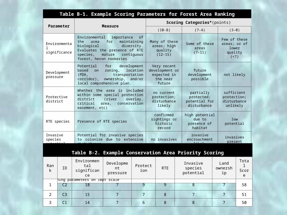
Table B-1. Example Scoring Parameters for Forest Area Ranking
Parameter MeasureScoring Categories*(points)
(10-8) (7-4) (3-0)
Environmental significance
Environmental importance of the area for maintaining biological diversity. Evaluates the presence of RTE species, mature contiguous forest, heron rookeries
Many of these areas; high quality
(12-15)
Some of these areas(7-11)
Few of these areas; or of lower quality
(<7)
Development pressure
Potential for development based on zoning, location (PDA, transportation corridor), ownership, and/or local comprehensive plan.
Very recent development or expected in the
near future
future development
possiblenot likely
Protective district
Whether the area is included within some special protection district (river overlay, critical area, conservation easement, etc)
no current protection;
disturbance likely
partially protected; potential for disturbance
sufficient protection;disturbance
unlikely
RTE species Presence of RTE speciesconfirmed
sightings or historic record
high potential due to presence of
habitatlow potential
Invasive species potential
Potential for invasive species to colonize due to extensive disturbance
no invasivesinvasive
encroachment likely
invasives present
Land ownership/ cost
Ease of protection based on ownershipowned by county,
land trust, or public institution
private ownership in relatively large
tracts
private ownership slated for development
* Environmental significance is an overall general ranking and is on a 0-15 point scale, remaining parameters on 10pt scaleTable B-2. Example Conservation Area Priority Scoring
Rank
IDEnvironmental
significanceDevelopmen
t pressureProtection RTE
Invasive species potential
Land ownership
TotalScore
1 C2 18 7 9 9 8 7 58
2 C3 15 7 7 8 7 7 51
3 C1 14 7 6 8 8 7 50
Powhatan Creek Priority Conservation Areas
51
Tools for Conserving and Enhancing Forests
• Conservation Easements
• Forest conservation and tree protection regulations
• Land acquisition
• Purchase or transfer of development rights
• Shading and canopy requirements
• Urban forestry management plans
Summary
• Plenty of ecological and health reasons to protect and increase tree cover