DEVELOPING BIODIVERSITY INDICATORS AS A TOOL FOR REGULATING DEVELOPMENT ACTIVITIES IN AND AROUND PROTECTED AREAS AND WETLAND REGIONS IN THE NORTH WEST PROVINCE OF CAMEROON Final Report 25 August 2006 Fon Nsoh (Team Leader), Fomboh Abraham Afese and Neba Celestine Community Initiative for Sustainable Development (COMINSUD) P.O. Box 356 Mankon – Bamenda North West Province - Cameroon Telephone number: (237) 766 64 86 / (237) 336 39 20 Email address: [email protected]
Transcript
DEVELOPING BIODIVERSITY INDICATORS AS A TOOL FOR REGULATING DEVELOPMENT ACTIVITIES IN AND AROUND PROTECTED AREAS AND WETLAND REGIONS IN THE NORTH WEST PROVINCE OF CAMEROON
Final Report
25 August 2006
Fon Nsoh (Team Leader), Fomboh Abraham Afese and Neba Celestine
Community Initiative for Sustainable Development (COMINSUD)
5 CONCLUSIONS AND RECOMMENDATIONS....................................................................12
5.1 COMMON PROBLEMS OBSERVED IN THE PROTECTED AREAS AND WETLANDS IN THE NORTH WEST...................................................................................12
5.3 SOME CHALLENGES FROM COMMUNITY BASED WORKSHOP .....................13
APPENDIX 1: LIST OF ACRONYMS......................................................................................15
APPENDIX 2: SOME EXAMPLES OF IMPORTANT BIODIVERSITY SPECIES..................15
APPENDIX 3: INFORMATION QUESTIONNAIRE.................................................................17
APPENDIX 4: IMPLEMENTATION AND ACHIEVEMENT OF PROJECT OBJECTIVES.....20
APPENDIX 5: PHOTOGRAPHS OF THE PROJECT AREAS AND PROJECT ACTIVITIES22
APPENDIX 6: SUMMARY OF INFORMATION COLLECTED IN THE COMMUNITIES ON THE SIX PROTECTED AREAS AND WETLANDS................................................................28
APPENDIX 7: COMMUNITY ACTION PLANS ......................................................................48
Biodiversity indicators for protected areas in NW Cameroon
CBBIA Final Report (25 August 2006) - 3 - COMINSUD Cameroon
ACKNOWLEDGEMENTS
COMINSUD wishes to acknowledge the rich contributions of all those who contributed in one-way or the other to the effective realisation of this project.
Our special appreciation goes to Mr. Charles Takwe of CAMCOF, Mrs Ingram Verina of the SNV Highlands-Cameroon, the executives of WHINCONET (Mr Paul Ndzeka, Tanyi Cyprain, Chi Napoleon and Jaap Van der Waarde-Coordinator of the WHINCONET-IAIA project) for their methodological support in the process of implementing the project.
We sincerely appreciate the help provided by Chi Napoleon, Jaff Francis, Timben Wartrace, the Provincial chief of Environment and Protected Areas and chief of Flora and Fauna and their staff who served as facilitators and resource persons during the community based workshops and information collection process.
We equally acknowledge the contributions made by mayors of the various councils and the Traditional Rulers in mobilising their population, providing venues for the meetings as well as necessary vital information.
Finally, much gratitude goes to the staff of COMINSUD for effectively carrying out the activities that ensured effective implementation of the project.
Biodiversity indicators for protected areas in NW Cameroon
CBBIA Final Report (25 August 2006) - 4 - COMINSUD Cameroon
DEVELOPING BIODIVERSITY INDICATORS AS A TOOL FOR REGULATING DEVELOPMENT ACTIVITIES IN AND AROUND WETLANDS AND PROTECTED AREAS IN THE NORTH WEST
PROVINCE OF CAMEROON
EXECUTIVE SUMMARY
This COMINSUD (Community Initiative for Sustainable Development) project is one of five projects selected under the CBBIA-IAIA Protected Areas Project (PAP). Its aim is to enhance capacities for biodiversity impact assessment, regulation and monitoring in protected areas and wetland regions in the North West Province, using indicators developed by key stakeholders. This region has very rich biodiversity and contains some globally rare and endemic species, according to some projects carried out by Bird Life International in the area. Protected areas in the North West Province were created between 1934 and 1971. However, although more than eight of such areas exist, due to poor management and neglect, they are all seriously degraded.
The overall goal of the project is, therefore, that people in the North West manage protected areas and wetland regions for the benefit of the local communities while maintaining their ecological value in the long term.
The project was implemented between May – December 2005, according to the following five key steps:
1. CBBIA-PAP training and capacity building activities preceding the 25th annual conference of the IAIA.
2. Discussion meetings with key project partners (SNV Highlands, CAMCOF, WHINCONET) to select the areas where activities will take place and to further develop the project’s methods.
3. Consultation and awareness meetings with respect to conservation issues on the state and perception of protected areas and wetlands were carried out at six selected sites with different stakeholders. This was followed by a presentation of the findings to Government Departments at provincial level with major interests in these sites.
4. Six community-based workshops were organised in various sites and over 300 people informed of the issues and trained, so that they are better able to respond to conservation issues and use resources sustainably.
5. Production of a user manual with biodiversity indicators, using information generated during the consultation events and community-based workshops.
The project has succeeded in stimulating conservation and sustainable resource use in all the six sites where activities took place. According to the community members in the areas where reserves are found, it was the time that they had discussions with government officials about the reserves. Natural resource management committees were created in the six sites to continue with awareness activities and the development of action plans to enhance conservation efforts and sustainable resource management practices. As a result, municipal councils and village authorities are strongly motivated to continue with the initiatives set in motion and the government’s Technical Services are ready to collaborate with them.
This CBBIA-IAIA PAP initiative should be viewed as a rapid measure to deal with current urgent requirements, as well as providing a basis for future action in this fragile ecological region.
Biodiversity indicators for protected areas in NW Cameroon
CBBIA Final Report (25 August 2006) - 5 - COMINSUD Cameroon
DEVELOPING BIODIVERSITY INDICATORS AS A TOOL FOR REGULATING DEVELOPMENT ACTIVITIES IN AND AROUND WETLANDS AND PROTECTED AREAS IN THE
NORTH WEST PROVINCE OF CAMEROON
1 BACKGROUND
1.1 THE PROJECT AREA
The North West Province of Cameroon is located in the Western Highlands of Cameroon (see Figure 1.1). It constitutes part of the mountain chains that cover parts of west Cameroon and East Nigeria and includes the remarkable Mt. Oku, which at 3,008m is the second highest peak in West Africa. The region also contains a multitude of forests, springs, rivers, volcanic lakes and a very rich biodiversity. Appendix 2 lists some examples of important species in the region. The total land area of the North West Province is 17,409km2 about 3.7% of Cameroon’s total land surface.
Two distinct seasons make up the climate of this region: a rainy season that runs from mid-March to mid-November and a dry season from mid November to mid-March. The average annual rainfall in the region is 2,000 mm. During the dry season average day temperatures reach up to280C but are as low as 150C in the rainy season.
The North West Province consists of several large water catchments; the Bui and the Noun rivers flow into the Sananga in the East, the Donga, Katsina Ala and Menchum rivers flow West to join the Benue in Nigeria, while the Momo River flows into tributaries of the Cross River in Mamfe. Other water bodies include crater lakes (Oku, Nyos, Awing, Bambili, Wum and Befang) and the Bamendjin, which supplies water for hydro-electricity production and also serves as a major fishing ground.
There are numerous plains between the high peaks such as the Ndop the Menchum, the Mbo and Mbaw plains, which receive sediments from the hills and are very fertile.
1.2 SOCIO-ECONOMIC CHARACTERISTICS
The province is divided into seven administrative divisions (Donga-Mantung, Menchum, Boyo, Bui, Momo, Ngoketungia and Mezam) and 31 sub-divisions. It is one of the three zones with the highest population concentration in the country. There were 429,100 inhabitants in 1953, which rose to 1,120,255 inhabitants in 1987 and it is now predicted that there will be two-million inhabitants by 2010 (though the results of the 2005 population census is likely to indicate that the population is already far higher than this).
Agriculture and extractive activities are the main occupations of the population given the fact that this region is generally lacking in manufacturing and processing activities; making it the poorest region in the country. Coffee, the main cash crop over the years, has declined in production since the mid-1980s due to a fall in prices in the world market. According to Cameroon’s Millennium Development Goals Progress Report (December 2003), 52.5% of the population in the province live below the poverty line and it is the second poorest province in the country. This figure contrasts with the national average, which is 40.2% and has decreased from 50.5% in 1996.
Biodiversity indicators for protected areas in NW Cameroon
CBBIA Final Report (25 August 2006) - 6 - COMINSUD Cameroon
Figure 1.1 Map of the Northwest Province of Cameroon showing project areas and Wetlands
#S#S
#S
#S#S#S
#S#S
#S
#S#S#S
#S
#S#S #S#S#S#S
#S#S
#S#S#S
#S #S#S
#S#S#S#S#S#S#S
#S
#S
#S
#S
#S
#S#S#S
#S
#S
#S#S#S#S#S
#S#S#S#S
#S#S
#S
#S#S#S
#S#S#S#S #S#S
#S
#S#S#S
#S#S#S#S#S #S#S#S
#S#S#S
#S#S#S
#S
#S#S
#S
#S#S
#S
#S#S#S
#S
#S#S #S#S
#S
#S
#S
#S#S
#S#S
#S#S
#S
#S
#S#S
#S#S#S
#S
#S#S#S
#S#S
#S#S#S
#S
#S#S
#S
#S
#S
#S#S#S
#S#S
#S#S
#S
#S
#S#S#S#S
#S#S#S#S #S
#S#S
#S
#S#S#S #S
#S
#S #S
#S#S
#S
#S#S#S
#S
#S #S#S
#S#S#S#S
#S
#S#S#S
#S
#S#S
#S#S#S
#S#S#S
#S#S
#S#S
#S
#S#S#S
#S#S#S
#S#S
#S#S
#S#S
#S#S#S #S#S
#S #S#S#S#S#S
#S
#S#S#S#S
#S
#S#S#S
#S#S
#S#S
#S#S #S#S#S
#S
#S#S
#S#S#S
#S#S
#S#S#S#S
#S#S#S
#S#S#S #S #S#S
#S
#S#S#S#S#S
#S
#S#S
#S#S#S
#S#S#S
#S#S#S
#S#S
#S#S#S#S
#S#S#S#S
#S#S#S#S#S#S
#S
#S#S
#S
#S
#S#S#S#S#S
#S#S#S#S#S#S
#S#S#S#S#S#S
#S#S#S
#S#S#S#S#S#S#S#S#S#S#S#S#S#S
#S#S#S#S#S#S#S#S
#S
#S#S#S#S#S #S
#S#S#S#S#S#S
#S
#S#S
#S
#S#S #S
#S
#S
#S
#S#S#S
BUI
MENCHUM
BOYO
MOMO
MEZAM
DONGA-MANTUNG
NGOKETUNJIA
Fungom Forest Reserve
Mbembe Forest Reserve
Kom-Wum Forest Reserve
Ndop Plain
Kimbi River Fauna Reserve
Bafut Ngemba Forest Reserve
Mountain Forest/plant life Sanctuary
Mbi Creater
Bali Ngemba Forest Reserve
Lake Nyi
L. Enep
L. Nyos
Lake Elum
L. Bambili
L. Bambuluwe
Dukari
Katsina Ala
Kimbi
Mete
Koaka
Menchum
Jonga
Movum
Mugom
SOUTH WEST
ADAMAOUA
WEST
N I
G E R I A
N I G E R I A
Dumbo Cattle
Ranch
Protected areas and
wetlands of focus
Other protected areas
#S Settlement
Lakes
RIVERS
Major
Minor
Stream
Divisional
Provincial
BOUNDARIES
Provincial
National
ROAD NETWORK
LEGEND
7 0 7 14 Kilometers
Source: Sanclou Engineering Ntarinkon
Date: January 2006
Disclaimer: The boundaries drawn have no legal validity
DIVISIONAL MAP OF THE NORTH WEST PROVINCE OF CAMEROON
SHOWING PROTECTED AREAS AND WETLANDS
N
Wetland basins in this region are an important food production area providing over 50% of food resources for the region and a major source of income for different user groups. Continuous and uncontrollable encroachment and over-exploitation of wetland resources due to population growth and the fertility of the land has increased resource pressures and conflicts by upsetting ecological balances and putting biodiversity at risk. Most affected are women who, as a result of cultural factors, have less access to resources and are further exposed to hardship by the depletion of resources on which their livelihoods depend.
Despite the fact that women do much of the work (household and farming) they still suffer the effect of poverty more than men. They lack access and control over productive and social resources and are poorly represented in decision-making in areas affecting their lives at household and community level.
The impact of HIV/AIDS in this region is also very high with an 8.5% prevalence rate as against a national prevalence rate of 5.5% in 2004.
Biodiversity indicators for protected areas in NW Cameroon
CBBIA Final Report (25 August 2006) - 7 - COMINSUD Cameroon
1.3 THE PROBLEMS TO BE TACKLED BY THE PROJECT
The North West Province is an ecological fragile zone that continues to suffer from increasing environmental and biodiversity degradation. The main threats to protected areas and wetlands in this region are:
• Deforestation arising from unsustainable exploitation of forests for fuel wood and timber, and harvesting of non-timber forest products.
• Forest clearing and irrigation for farming and other development projects.
• Bush fires, which are commonly used by hunters in the dry season to obtain game, or by cattle breeders as an easy means of clearing vegetation for regeneration of fresh pasture for their cattle.
• Poverty that has pushed cultivation into wetlands.
• Poor agricultural practices and deforestation, leading to silting of wetlands and alteration of the habitat of certain species.
• Reductions in water levels (by pumping) in wetlands by local inhabitants to facilitate fish catches.
If great attention is not paid to sustainable management practices and conservation efforts particularly in wetland areas the risk of ecological imbalance could be very high as a result of desertification. Threats from different forms of encroachment for agricultural activities, and exploitation of forest and water resources are at the base of biodiversity loss. Communities adjacent to the forests and wetlands are aware of their values and the important resources derived from them but these communities and the responsible departments (NGOs, councils and government services) lack the capacity to achieve effective conservation and sustainable resources management.
Protected areas (reserves) in the North West were created between 1934 and 1971. Although eight protected areas exist in this region unfortunately they have not been given priority in conservation efforts and continue to suffer from different forms of degradation. Apart from the Kimbi Game Reserve, where demarcations of the boundaries of the reserve and erection of new signposts are some recent actions, concrete conservation actions are completely absent. Wetlands ecosystems especially in the woody savannah receive little or no attention. Wetlands in Cameroon have no classification or protection status. The following wetlands are of importance to the project:
• The Ndop plain, which are extensive wetlands and characterised by intensive human activities.
• Lake Bambuluwe (Lake Awing) located in the Bafut – Ngemba Forest Reserve and is classified as an international tourist site. Of equal importance is lake Oku situated in the Mountain/Forest plant life sanctuary and is a site for the rare and globally endangered Bannerman’s Turaco (Tauraco bannermani).
• Rivers Donga and Kimbi that join to form the river Katsina Ala that flows into Nigeria and is therefore of international importance.
The Government of Cameroon is committed to implementing the Convention on Biodiversity Diversity. Therefore a Ministry of Environment and Forestry was created in 1994 from the Ministry of Agriculture, and subsequently several laws and policies have been enacted in accordance with international conventions related to biodiversity management and conservation. A typical example is the creation of the National Biodiversity Committee following decision No 0002/D/MINEP/CAB/CT1/PF-CBD by the Ministry of Environment and Protection of Nature. The main stakeholders are relevant government services (Provincial Delegations of Agriculture, Environment and Forestry, Livestock and Fishery, Tourism), local
Biodiversity indicators for protected areas in NW Cameroon
CBBIA Final Report (25 August 2006) - 8 - COMINSUD Cameroon
councils, NGOs and community based groups, and those that rely on biodiversity, including farmers, fishermen, hunters, sand excavators, craftsmen, herbalists, and cattle breeders.
2 PROJECT GOAL / OBJECTIVES
The overall goal of the project is to enable people in the North West Province to manage protected areas and wetland regions for the benefit of the local communities while maintaining their ecological value in the long term.
To achieve this, the project’s objectives are to ensure that:
• Sufficient capacities for biodiversity impact assessment and monitoring exist for the regulation of activities in the protected areas and wetland regions based on indicators developed by key stakeholders.
• Ten NGOs and three relevant government services increase their capacity to undertake impact assessment and advocate for sustainable management and conservation of protected areas and wetland regions with local communities.
• Biodiversity indicators as tools for regulating development activities in and around protected areas and wetland regions are developed and produced in a user manual.
• A wide public constituency emerges that supports conservation and sustainable resource management in five protected areas and wetland regions, with the backing of the local councils and user groups.
3 APPROACHES AND METHODS
The project was carried out through:
1. Participatory community mapping
In each location participants worked in groups to develop a community map showing different wetland types in their community, the area covered by the reserves in relation to adjacent villages and communities and activities carried out in the reserves.
2. Stakeholder analysis
To effectively understand the activities of all the stakeholders, an analysis of the activities carried out in wetlands and reserves was done with particular focus on those that are threats to biodiversity.
3. Action plan preparation
To enhance community-based management of wetlands and reserves, communities prepared action plans as a step towards biodiversity conservation. The action plans for the communities were drawn up following the threats resulting from the activities of the different actors in the wetland and forest reserves. The following points were considered in the elaboration of each action plan:
• What are we going to do?
• Enhancement of community based management of wetlands and forest reserve.
• Objectives (proposed solution to be implemented).
• Use of indicators within the user groups.
Biodiversity indicators for protected areas in NW Cameroon
CBBIA Final Report (25 August 2006) - 9 - COMINSUD Cameroon
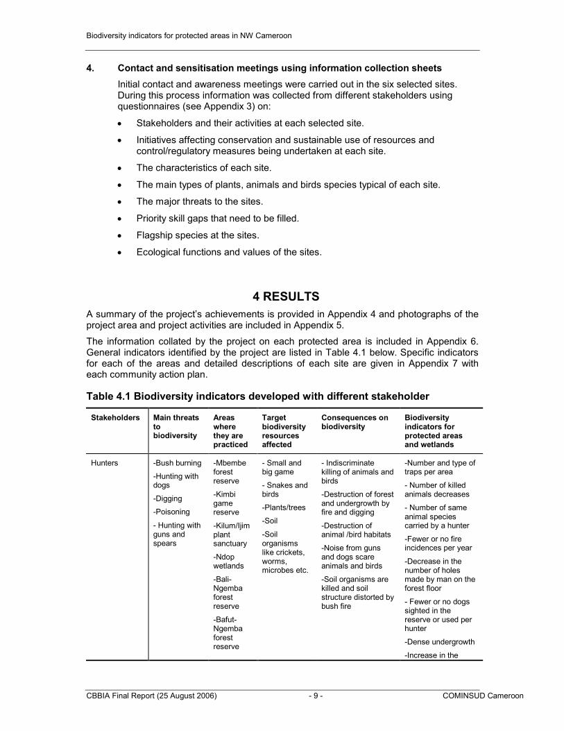
4. Contact and sensitisation meetings using information collection sheets
Initial contact and awareness meetings were carried out in the six selected sites. During this process information was collected from different stakeholders using questionnaires (see Appendix 3) on:
• Stakeholders and their activities at each selected site.
• Initiatives affecting conservation and sustainable use of resources and control/regulatory measures being undertaken at each site.
• The characteristics of each site.
• The main types of plants, animals and birds species typical of each site.
• The major threats to the sites.
• Priority skill gaps that need to be filled.
• Flagship species at the sites.
• Ecological functions and values of the sites.
4 RESULTS
A summary of the project’s achievements is provided in Appendix 4 and photographs of the project area and project activities are included in Appendix 5.
The information collated by the project on each protected area is included in Appendix 6. General indicators identified by the project are listed in Table 4.1 below. Specific indicators for each of the areas and detailed descriptions of each site are given in Appendix 7 with each community action plan.
Table 4.1 Biodiversity indicators developed with different stakeholder
Stakeholders Main threats to biodiversity
Areas where they are practiced
Target biodiversity resources affected
Consequences on biodiversity
Biodiversity indicators for protected areas and wetlands
Hunters -Bush burning
-Hunting with dogs
-Digging
-Poisoning
- Hunting with guns and spears
-Mbembe forest reserve
-Kimbi game reserve
-Kilum/Ijim plant sanctuary
-Ndop wetlands
-Bali-Ngemba forest reserve
-Bafut-Ngemba forest reserve
- Small and big game
- Snakes and birds
-Plants/trees
-Soil
-Soil organisms like crickets, worms, microbes etc.
- Indiscriminate killing of animals and birds
-Destruction of forest and undergrowth by fire and digging
-Destruction of animal /bird habitats
-Noise from guns and dogs scare animals and birds
-Soil organisms are killed and soil structure distorted by bush fire
-Number and type of traps per area
- Number of killed animals decreases
- Number of same animal species carried by a hunter
-Fewer or no fire incidences per year
-Decrease in the number of holes made by man on the forest floor
- Fewer or no dogs sighted in the reserve or used per hunter
-Dense undergrowth
-Increase in the
Biodiversity indicators for protected areas in NW Cameroon
CBBIA Final Report (25 August 2006) - 10 - COMINSUD Cameroon
Stakeholders Main threats to biodiversity
Areas where they are practiced
Target biodiversity resources affected
Consequences on biodiversity
Biodiversity indicators for protected areas and wetlands
number of wildlife corridors
Farmers -Clearing of grass
-Felling of trees
-Burning of grass and soil
-Tilling
-Chemicals
-Mbembe forest reserve
-Ndop wetlands
-Bali-Ngemba forest reserve
-Bafut-Ngemba forest reserve
-Soil
-Grass
-Plants/trees
-Wildlife
-Soil organisms (worms, crickets etc.)
-Water
-Indiscriminate cutting down of tree and plant species
-Destruction of soil organisms
- Erosion of top soil
-Destruction of soil texture and structure by fire
-Burning of litter on the forest floor leading to infertility
-Damage to wetlands
-Destruction of animal /bird habitats
- Soil and water pollution
-Closed forest canopy
-Dense undergrowth
-Surface area without trees or scanty number of trees decreases
- Surface area burn/Number of fire incidences per year decreases
-Number of farmers/frequency of shifting cultivation
-Surface area with ridges decreases
-Quantity of litter on the forest floor increases
-Dark soil colour
-Fungi, crickets and worms frequently seen
NTFP Users
-Herbalist
-Wild fruit and spice harvesters
- Honey harvesters
-Fuel wood collectors and harvesting
-Harvesting of honey with the use of fire
-Felling of trees
-Mbembe forest reserve
-kimbi game reserve
-Kilum/Ijim plant sanctuary
-Ndop wetlands
-Bali-Ngemba forest reserve
-Bafut-Ngemba forest reserve
-Trees
-Herbs
-Soil
-Bees
-Honey
-Wild fruits and spices
-Mushroom
-Soil
- Hives and bees being damaged by fire
-Felling of trees by some people
-Destruction of trees and grass by fire
-Digging of the soil
- Impacts on some soil fauna
-Uncontrolled harvesting and extinction of some plant species
-Decrease in the number of felled trees
-Number of holes created by man on the forest floor decreases
-Number of birds and wildlife living on wild fruits increases
- Quantity of wild fruits and spices in the market increases
-Number of colonised hives in the forest increases
-Thick forest undergrowth
-Mushroom frequently seen
-Number of trees in the forest with ringed barks and dug out roots decreases
- Forest canopy becomes dense
Biodiversity indicators for protected areas in NW Cameroon
CBBIA Final Report (25 August 2006) - 11 - COMINSUD Cameroon
Stakeholders Main threats to biodiversity
Areas where they are practiced
Target biodiversity resources affected
Consequences on biodiversity
Biodiversity indicators for protected areas and wetlands
Fishermen -Damming
-Fishing with chemicals
-Digging and draining of wetlands
-Mbembe forest reserve and wetlands
-kimbi game reserve
-Ndop wetlands
-Water
-Fish
- Water birds and animal species
-Indiscriminate fish catch
-Killing of fishers and other aquatic life using natural and artificial chemicals such as Garmaline, tephrosia and some backs of trees
-Scaring of water birds and animals during fishing
-Pollution of water bodies with chemicals
-Size of fish caught increases per year
-Decrease in the quantity dead fish and other aquatic life
-Frequent and regular use of the correct type and sizes of nets and cages
-Number of and frequency dams and blockages constructed decreases
Grazers -Free range grazing
-Bush burning
-Construction of fences
-Chemicals
-Mbembe forest reserve
-kimbi game reserve
-Kilum/Ijim plant sanctuary
-Ndop wetlands
-Bali-Ngemba forest reserve
-Bafut-Ngemba forest reserve
-Grass
-Trees and herbs
-Soil
-Wildlife species and birds
-Water
- Soil Erosion
- Soil and water Pollution
-Soil Compaction
-Destruction of wildlife habitats
-Destruction of young and fragile plant and tree species
-Few cattle tracks in the reserve
-The frequency of bush fires and areas of the reserve affected by bush fires decreases
-Undergrowth remains intact
- Absence of cow dung or frequency at which cows are sighted in reserve reduces
-Purity of water sources
-Decrease in the number of eroded areas in the reserve
-Promotion of tourism
-Planting of alien species
-Deforestation
-Mbembe forest reserve
-kimbi game reserve
-Kilum/Ijim plant sanctuary
-Ndop wetlands
-Bali-Ngemba forest reserve
-Bafut-Ngemba forest
-Trees
-Various animal/bird species
-Water
-Increase in revenue collected from forest exploitation and tourism
-Birds and wildlife number increases
-Closed forest canopy
-Undergrowth become dense
- Boundary of reserve remain intact
-Area covered by forest increases
-Fewer or no eucalyptus and cypress trees and
Biodiversity indicators for protected areas in NW Cameroon
CBBIA Final Report (25 August 2006) - 12 - COMINSUD Cameroon
Stakeholders Main threats to biodiversity
Areas where they are practiced
Target biodiversity resources affected
Consequences on biodiversity
Biodiversity indicators for protected areas and wetlands
forest reserve
other alien species in the reserves
- Increase in the number of tourists per year
5 CONCLUSIONS AND RECOMMENDATIONS
5.1 COMMON PROBLEMS OBSERVED IN THE PROTECTED AREAS AND WETLANDS IN THE NORTH WEST
The project found that conservation of biological diversity is weak in all the six areas. Although five of the six areas are protected sites by law, a remarkable decline in biodiversity was noticed and reported during the information collection and awareness process as well as during the community-based workshops. The following reasons account for declines in biological diversity in these areas:
• Absence of a functional management plan that defines the purpose of the protected area, and its management approaches and strategies.
• Insufficient personnel and equipment to undertake conservation activities. The Kimbi Game Reserve which covers 6,000ha has only one conservationist to take care of it, while other sites have only one person as a forestry post officer to serve a whole sub-division.
• Sustainable use of biodiversity components is poorly regulated in most of these sites. There is a very high level of encroachment into the protected areas by different interest groups for settlement, farming, grazing, timber and game exploitation, and collection of non-timber forest resources etc.
• Buffer zones do not exist for some of the protected areas while in others they are poorly managed, e.g. in the Kimbi Game Reserve, buffer zones are extensively burned by herdsmen and serve as grazing areas.
• There is insufficient information of what people should do and what they should not do in protected areas. One interesting aspect that was noticed is that local communities see protected areas as zones of complete prohibition as stipulated by law, yet filled with enormous resources that could provide for their livelihoods. Consequently they seek illegal means to exploit resources from these areas without consideration for sustainability or wise use in the case of wetlands.
• Distribution of benefits from conservation is far from being fair and equitable. User groups and local communities are not in any way involved in the management of protected areas. They do not take part in the decisions as far as management is concerned, nor are allocated particular benefits that result from management.
5.2 RECOMMENDATIONS
• There is a very strong need to develop a functional management plan for all the protected areas that take into consideration CBD Decision VI/7A i.e. an Ecosystem Approach that focuses on people nature interactions and stakeholder involvement. In this process, strengthening local communities to play an active part in the management of
Biodiversity indicators for protected areas in NW Cameroon
CBBIA Final Report (25 August 2006) - 13 - COMINSUD Cameroon
conservation efforts as well as increasing the benefits they may obtain from protected areas is fundamental.
• There is a need to undertake a deeper assessment of the impacts of stakeholder activities in wetlands and protected areas on biodiversity, as a step towards developing management plans for each area.
• There is limited knowledge and information about the actual state of biodiversity in some of the sites (i.e. Bafut-Ngemba, Mbembe and Ndop Wetlands), although some recent work has been done in Kilum/Ijim, Bali Ngemba Forest and Kimbi reserves. Therefore, further capacity building is necessary to undertake species inventories and other biodiversity surveys where information is required to plan conservation efforts.
• In view of the fact that there are eight protected areas in the North West province and many more across the country (as well as many large wetlands), there is a need to develop standards for managing and monitoring protected areas. A review of legislation and procedures for managing protected areas and wetlands should be considered with proper guidelines developed to enhance community participation.
• A study and classification of wetlands should be done and included in the legal system. Management strategies and options for different categories of wetlands should also be developed to ensure wise use of wetlands.
• Assessment of the protected areas should be undertaken to provide a proper valuation of each site to determine management objectives for each site. If they are protected areas then there may be reasons to protect them irrespective of their alternative economic values. Also it should be remembered that it is difficult to value some ecosystem functions properly – e.g. flood storage capacity. Such assessments could also provide guidance on mitigation measures to be taken to reduce or avoid detrimental impacts.
• The creation of Regional Conservation Boards for protected areas and wetlands according to different climatic/ecological zones should be considered as an option for decentralized and efficient management. In this way a highly centralized system could be avoided that provides for too much bureaucracy that is the basis of poor management. If such Regional Conservation Bards are created they should also be provided with autonomous status that will enable them to develop and implement management plans according to national guidelines.
5.3 SOME CHALLENGES FROM COMMUNITY BASED WORKSHOP
A key issue with the workshops has been a lack of knowldege amongst the participants on the issues affecting protected areas. The Lord Mayor of Santa Municipal Council, where the Bafut – Ngemba Forest is located, recognised this and therefore encouraged community participation and the sharing of ideas and the gaining of new knowledge on sensitive issues which had been neglected. He advocated the protection of resources, such as water catchments, for the sake of posterity and appreciated the importance of replacing ignorance with knowledge.
His Royal Highness, Fon Gitang Michael Bongla I of Kimbi also raised further challenges. He pointed out that the community has been deprived of its land for a long time without compensation. They do not benefit from the reserve and local people are not employed to work in it. Furthermore he decried the mismanagement of the reserve’s resources and asked COMINSUD to help them to regain their Game Reserve. He also noted that the workshop participants realize the valuable resources found in their communities and stated that the communities in and around Kimbi are willing to learn more from the workshop facilitators.
Through the preparation of community maps of their reserves and protected areas and by identifying and accessing their biodiversity resources, the participants gained a deeper
Biodiversity indicators for protected areas in NW Cameroon
CBBIA Final Report (25 August 2006) - 14 - COMINSUD Cameroon
understanding of the richness of their community. They also realised that biodiversity loss was evident, that some species have disappeared while others have declined considerably. They saw the need to embark on conservation measures and hence the need to develop action plans to support this process as a local initiative for which external assistance can be sort. As a consequence, COMINSUD and other stakeholders interested in the promotion of biodiversity conservation have to continue with the initiated process. This is very evident as the communities lack sufficient capacity to continue the process with the reserves in their current state of neglect.
Biodiversity indicators for protected areas in NW Cameroon
CBBIA Final Report (25 August 2006) - 15 - COMINSUD Cameroon
APPENDIX 1: LIST OF ACRONYMS
CAMCOF: Cameroon Mountain Conservation Foundation
CBD: Conservation of Biological Diversity
CBBIA: Capacity Building in Biodiversity and Impact Assessment
COMINSUD: Community Initiative for Sustainable Development
IAIA: International Association for Impact Assessment
MINEP: Ministry of the Environment and Nature Protection
NGO: Non-Governmental Organisation
PAP: Protected Areas Project
SNV: Dutch Development Organisation
WHINCONET: Western Highlands Nature Conservation Network
APPENDIX 2: SOME EXAMPLES OF IMPORTANT BIODIVERSITY SPECIES
English name Scientific name
Animals
Olive baboons Papio anubis
Black and White colobus Colobus guereza
Patas monkey Cercopithecus patas
Green monkey Cercopithecus tantalus
Mona monkey Cercopithecus mona
Scrub hare Lepus saxatilis
Striped ground squirrel Euxerus erythropus
Red legged sun squirrel Heliosciurus rufobrachium
African giant squirrel Protoxerus stangeri
Crested porcupine Hystrix cristata
Marsh cane rat Thryonomys gregorianus
Waterbuck Kobus ellipsiprymnus defassa
Bushbuck Tragelaphus scriptus
African civet Civettictis civetta
African buffalo Syncerus caffer
Slender mongoose Herpestes sanguinea
Emin’s Giant rat Cricetomys emini
Kob Kobus kob
Birds
Biodiversity indicators for protected areas in NW Cameroon
CBBIA Final Report (25 August 2006) - 16 - COMINSUD Cameroon
Cattle Egret Bubulcus ibis
Hamerkop Scopus umbretta
Hadada ibis Bostrychia hagedash
African Black Duck Anas sparsa
Osprey Pandion haliaetus
Black kite Milvus migrans
Palm-nut vulture Gypohierax angolensis
Hooded Vulture Necrosytes monachus
African White-backed vulture Gyps africanus
Crowned Eagle Stephanoaetus coronatus
Red-necked Buzzard Buteo auguralis
Black Sparrowhawk Accipter melanoleucus
Western Banded Snake Eagle Circaetus cinerascens
African Harrier Hawk Polyboroides typus
Green Turaco Tauraco persa
Great blue Turaco Corythaeola cristata
Grey parrot Psittacus erithacus
Red-headed Lovebird Agapornis pullarius
Red-eyed dove Streptopelia semitorquata
African jacana Actophilornis africanus
Double-spurred francoline Francolinus bicalcartus
African wood owl Strix woodfordii
Black Cuckoo Cuculus clamosus
Black bee-eater Merops gularis
Biodiversity indicators for protected areas in NW Cameroon
CBBIA Final Report (25 August 2006) - 17 - COMINSUD Cameroon
APPENDIX 3: INFORMATION QUESTIONNAIRE
Name of personnel________________________________________________ Project site_______________________________________________________ Information obtained from__________________________________________
1) Name of site_________________________________________________
2) Area covered (average depth of lake)____________________________
3) Protection status by law No____________________________________
4) A) Government interest on the site
B) Community interest in the site and their perception of biodiversity
5) Key Actors/Stakeholders in the site
Actors Their activities Impact on Biodiversity
Impression of the actors to the situation
Conflicts?
1. Users
2. Government
3. NGOs
4. CBOs
6) Which of the following initiatives is undertaken at the site
Initiatives Actors Main focus and scale
Successes Difficulties Suggestions
Conservation
Sustainable use of Resources
Control or regulatory
Biodiversity indicators for protected areas in NW Cameroon
CBBIA Final Report (25 August 2006) - 18 - COMINSUD Cameroon
regulatory measures/activities
7) What are the characteristics of the site
Characteristics Elements
1 2 3 4 5
� Species density; birds, animals, birds and plants
1. A wide public constituency in support of conservation and sustainable resource management emerged in 5 protected areas and wetland regions with the backing of the local councils and user groups.
• Carry out contact and sensitisation meetings in the target communities with various stakeholders
• Preparations were made with the councils, users groups and other stakeholders for capacity building workshops at community level
• Information sheets for sensitisation and information collection was produced and used in six (6) protected areas and wetland regions.
• The level of awareness of 61 key persons representing different target groups was raised (Government service – 19, Local Council –18, Traditional/village institutions 7, and User groups and community Based Organisations 27).
• An assessment of the state of each protected site or wetland was made based on information collection sheets prepared for the purpose.
• A strong motivation towards conservation, rehabilitation and enhancement of the various protected areas and wetlands was generated.
• A round table reflection meeting was organised on the theme: Management of Wetlands and Protected Areas from a Multi-Stakeholder Perspective.
• The reflection meeting attended by 14 persons: 3 from government services of Environment and Tourism, SNV 1, WHINCONET 3, Community Leader 1 and COMINSUD 6.
• The major conclusion of the reflection meeting was to seek avenues for enhancement of community participation in managing protected areas and wetlands, in keeping with laid down regulations that will promote conservation efforts and wise use.
10 NGOs and 3 relevant government services increase their impact assessment, advocate for sustainable management and conservation of protected areas and wetland sites with local communities
Organise a capacity building workshop for 25 stakeholders (NGOs, Local Councils, Officials, Relevant Government Services and user groups (12 days workshop)
• Community-based workshops were organised in six sites, 4 of which run for 2 days and two for 1 day.
• A total of 300 persons took part in the workshops with an impressive representation and active participation of all stakeholders.
• During the workshop extensive sensitisation of conservation need of protected areas and wise use of wetlands was carried out through brainstorming reflection sessions.
• The communities were enable to have a better understanding of their wetlands and protected areas through participatory mapping exercises of these areas, identification and determination of the state of wide life and an analysis of the types of activities taking place within.
• The various stakeholders and user groups analyse their activities in protected areas and wetlands as well as the threats caused to biodiversity.
• The different stakeholder groups developed biodiversity indicators that will serve in regulating their activities in protected areas and wetlands.
• The communities in six sites drew-up action plans for the future that will contribute in protecting biodiversity and contribute to the enhancement of their livelihood without threatening biodiversity.
Biodiversity indicators for protected areas in NW Cameroon
CBBIA Final Report (25 August 2006) - 21 - COMINSUD Cameroon
• Local Councils and village traditional institutions showed a very strong commitment to continue the process in future and were very instrumental in organising the workshops in their localities.
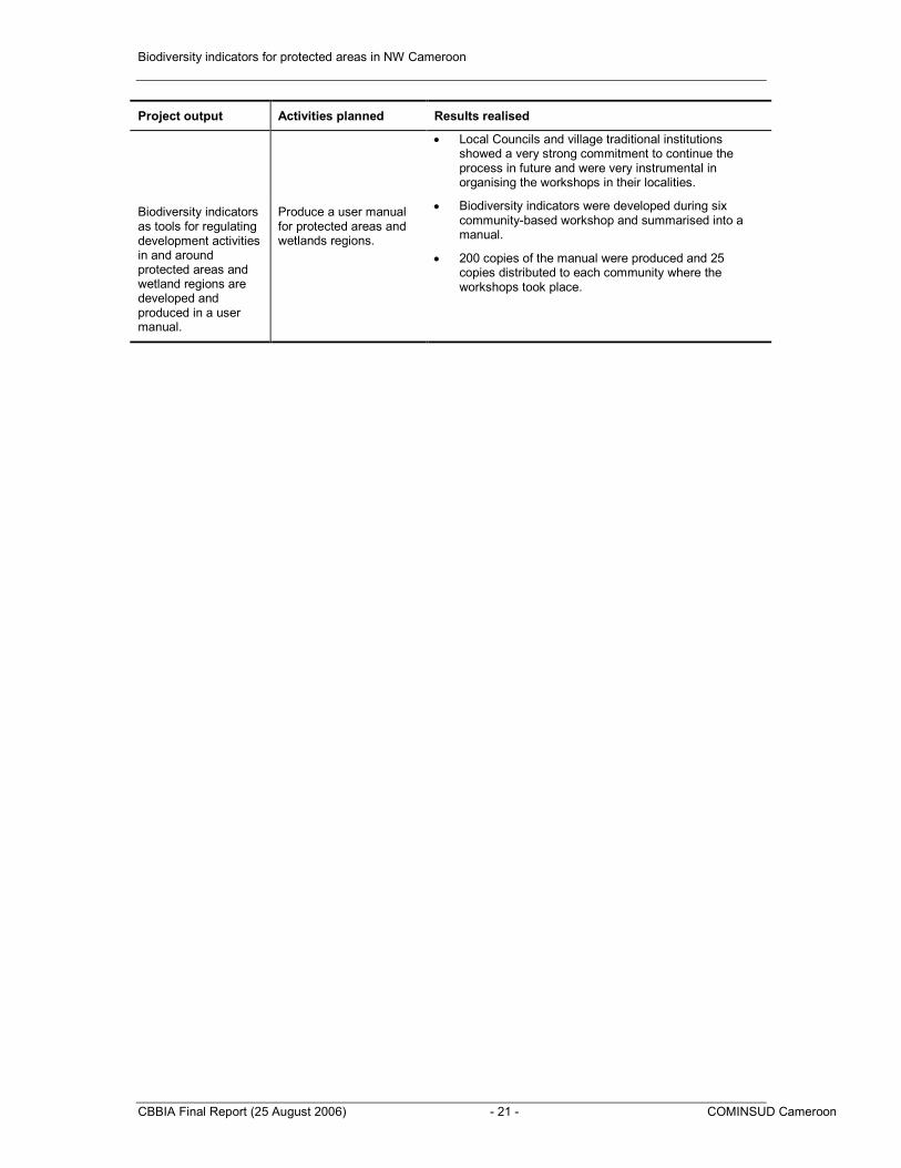
Biodiversity indicators as tools for regulating development activities in and around protected areas and wetland regions are developed and produced in a user manual.
Produce a user manual for protected areas and wetlands regions.
• Biodiversity indicators were developed during six community-based workshop and summarised into a manual.
• 200 copies of the manual were produced and 25 copies distributed to each community where the workshops took place.
APPENDIX 5: PHOTOGRAPHS OF THE PROJECT AREAS AND PROJECT ACTIVITIES
Part of Mbembe Reserve with settlement
Extensive Farming and Grazing activities in Bali – Ngemba and Bafut –Ngemba Reserve, a major threat to the reserves
Biodiversity indicators for protected areas in NW Cameroon
CBBIA Final Report (25 August 2006) - 23 - COMINSUD Cameroon
Exploitation of Eucalyptus an Alien species in Bafut-Ngemba Reserve
Bush fire- a major threat to protected areas
Kimbi Game Reserve Signpost- State property
Raffia exploitation
Part of Natural Forest in Bali – Ngemba Reserve with Dense undergrowth
Biodiversity indicators for protected areas in NW Cameroon
CBBIA Final Report (25 August 2006) - 24 - COMINSUD Cameroon
Ndop Wetlands
Awing Lake-a major touristic attraction in Bafut-Ngemba Forest Reserve
A river crossing the Mbembe Reserve
Rice field in Ndop -a major wetland activity
Biodiversity indicators for protected areas in NW Cameroon
CBBIA Final Report (25 August 2006) - 25 - COMINSUD Cameroon
Tectonia gradis plantation created in the Mbembe forest reserve by the government
Group work on Participatory village mapping
Participants during training workshop-Kimbi
Water catchment in Bali-Ngemba Reserve
Biodiversity indicators for protected areas in NW Cameroon
CBBIA Final Report (25 August 2006) - 26 - COMINSUD Cameroon
Participants presenting group work-community maps
Part of the Facilitation Team involved in Community base workshops
Biodiversity indicators for protected areas in NW Cameroon
CBBIA Final Report (25 August 2006) - 27 - COMINSUD Cameroon
Participants during community based workshops
Mbembe Ndop
Kimbi Bafut-Ngemba
Biodiversity indicators for protected areas in NW Cameroon
CBBIA Final Report (25 August 2006) - 28 - COMINSUD Cameroon
APPENDIX 6: SUMMARY OF INFORMATION COLLECTED IN THE COMMUNITIES ON THE SIX PROTECTED AREAS AND WETLANDS
6. Description: It is triangular in shape, borded on both sides by two major rivers (river Kimbi and river Donga. Patches of dense forest, scattered woody savanna and extensive grass cover make up the vegetation type.
7. Characteristics of the site
Elements Characteristics
1 2 3 4 5
Diversity in animal, plant and bird species x
Fragmentation (power lines, track, road, nature out comes and others). x
Human activities in the site X
Human settlements (number of villages / committees. x
Protection status X
1 – Very low, 2 – Low, 3 – Average, 4 – High, 5 – Very high
8. Analysis of conservation and land use initiative in the site
Actors involved Main focus & scale Successes/
Strength
Difficulties/
Weaknesses
Suggestions
-Government (conservator)
-Communities of Kimbi members
-Herbalist
-Brigade control
-Carvers
-Hunters
-Protect species like Kaya senegalensis
-Protect land, streams, rocks and touristic sites where two rivers meet
-Control and minimise illegal exploitation of medicinal plants
-Sensitisation of the public on sustainable use of resources
-Issue of hunting permits that start from November 31
st to
May 31st.
-Ensure effective protection of game
-There are still available number of plants, birds and mammals species in the reserve
-Tourists can visit the area thus bringing revenue to the community
-Abundant medicinal plants and water essential for regeneration
-There is awareness creation because most people come for hunting permit
-People pay penalty for illegal exploitation and sell of timber produce
-No sawing of plank in the
-The whole community is not involve in the conservation initiatives
-Serious reduction in game because poachers from Nigeria and neighbouring villages are damaging the reserve thus making conservation very difficult
-Over grazing
-Commercial permits have not been executed because of the political state of the country
-People bribe the conservator to exploit the reserve
-Active involvement of the community in the reserve
-Camps be put inside the reserve to host guards
-Burning/grazing should stop
-Government should compensate the villages that left the reserve land
-The reserve should be managed as stipulated or handed by to the community
-Anti poaching committee be set adjacent the community to track illegal hunting
-Improve farming system should be introduced
-There is need for management plan so as to know the limits of every activity in the reserve
-Recalcitrant/illegal exploiters should be
Biodiversity indicators for protected areas in NW Cameroon
CBBIA Final Report (25 August 2006) - 29 - COMINSUD Cameroon
plank in the reserve for fuel wood
-No farming in the reserve
punished persons transporting wood
-People should be encourage to plant prunusetc
9. Stakeholder Analysis
Stakeholder Activities
and
Interest
Resources Threats to Wetlands and Protected areas
Indicators or signal
Traditional Authority/
Council
-Fishing camp signal danger
-Forest and game R.
-Water dog
-Buffalos horns
-Tiger skin
/
-Number of horns brought in space
-Number of Tiger skin/year
Government/Ministry of Environment
-Patrol /supervision
-Fire tracing
-Control burning
-Animals
-Grass/forest
Complicity to graze/burning
- Increase Number of big games
-Diverse habitat for game
Farmers -No farming in the reserve
-Burning outside the reserve
-Food crops -Burning of the hill and buffer zone.
-No direct threat the reserve
-Presence of worms in the soil.
-Dark soil colour
-Special plant species “Nganga”, and “Mbiya”
-Mushroom/ cricket seen
-Litter thickness on forest floor very high
Grazers -Grazing -Grass
-Water
-Stick
-Herbs
-Fight between buffalos and cattle
-Burning in the buffer zone and reserve.
-Grazing in the reserve during dry.
-Noise of cow scare small animals
-Reduction in the number and frequency of fire incidences
-Area/portions of the reserve affected by fire decreases
-Portions of undergrowth not intact due to fighting between buffalos and cows
-The frequency at which cows are sighted in the reserve reduces
Council -Employment
-Revenue
-Control and protection
-Animals
-Plants
-Water
/
-Increase Number of tourist (Visitors book)
-Same as government
Hunters -Catch games
-Trapping
-Digging
-Games -Noise of gun shoot
-Number of animals hit by vehicle frequently
-Number of games moving out of the reserve/ protected area frequently
-Fewer or no dogs sighted in and around the reserve as well as use by hunters for hunting
-Number of hunting permit issued by government.
-Number of holes in the reserve created by man decreases
Fishermen -Hooking
-Diving
-Fishes
-Water
/
-Frequent and regular use of net of appropriate size
Biodiversity indicators for protected areas in NW Cameroon
CBBIA Final Report (25 August 2006) - 30 - COMINSUD Cameroon
-Regular catch of the recommended size of fish
-Increase in the quantity of fish catch per year
Herbalist/NTFP -Harvesting of medicinal plants
-Cutting of tree outside the reserve
-Herbs
-Wood
/
-Larger plants like mahogany, iroko etc.
-Increase Number of medicinal plant species
Government
Ministry of Agriculture
-Training on sustainability
-Farming
/
/ /
Schools -Excursion
-Research
/
/ /
Administration
Divisional Officer (D.O)
-Authorization and implementation of laws
/
/ /
10. Existing and potential Conflicts in the site
Actors Reasons
Farmers Vs Graziers
Farmers Vs Hunters
Indigenes Vs Government
There is no Management Plan for the Reserve and lack of reserve demarcation for each activity
Individual (Alh Baba Ndanpullo forcefully grazed his cows in the reserve) Vs Goverment
Individuals taking rights in to their hands due to strong financial fist
Fon of Kimbi Vs Government -The Fon refuse the Government to take lake Oku as part of the reserve because nothing good is being done to the reserve already taken -The reserve does not create employment for the indigenes
CBOs Vs Government CBOs have discovered that their land taken by the government is being mismanaged and want it back. To them it is no more a protected area
11. List of biodiversity (see examples in Appendix 2)
Animals As of 2003, 21 mammals have been recorded in the reserve
Birds 220 species of Birds have been identified in the reserve
Plants 98 species of plants have been recorded in the reserve
Biodiversity indicators for protected areas in NW Cameroon
CBBIA Final Report (25 August 2006) - 31 - COMINSUD Cameroon
1. Name of Site: Mbembe Forest Reserve
2. Location: Ako Sub- Division, Boyo Division
3. Area covered: 28,490Ha
4. Protection status: Decree No 50 of 21/07/1934
5. Year of creation: 1934
6. Description: It is punctuated with settlements such as Buka, Ako town, Abongshie, Akwesse and Ngomo. One main river (River Akong) cuts across the reserve to meet with river Donga that shares boundary with Nigeria. Fragmented dense forest, scattered woody Savanna and extensive grass cover constitute the vegetation type.
7. Characteristics of the site
Elements Characteristics
1 2 3 4 5
Diversity in animal, plant and bird species X
Homogeneity X
Fragmentation (power lines, settlement, track, road, nature out comes and others).
X
Human activities in the site X
Human settlements (number of villages / committees. X
Protection status X
Others
1 – Very low, 2 – Low, 3 – Average, 4 – High, 5 – Very high
8. SWOT analysis of conservation and land use initiative in the site
Actors involved Main focus & scale Successes/
Strength
Difficulties/
Weaknesses
Suggestions
-Government
-CBOs
-NGOs
-Community members
-Herbalist
-Carvers
-Hunters
-Protection of the reserve and Wetlands
-Sensitisation of the public on sustainable use of resources
-Control and enhance the exploitation of medicinal plants
-Existence of FMIs
-Tourists can visit the area thus bringing revenue to the community
-Abundant medicinal plants
-Demarcation of community forestry
-Tectonia grandis plantation is in place
-Nursery exist
-Rough nature of terrain
-Lack of good projects
-Wrong perception by communities and differences in opinion on the need for conservation
-Limited number of personnel
-Much pressure on resources by the population
-Conflicts between different actors
-Active involvement of the community in the reserve
-More sensitisation of the communities on the importance of the reserve and the need for protection
-Conservation projects be developed
-More personnel to enhance the protection of the forest
Biodiversity indicators for protected areas in NW Cameroon
CBBIA Final Report (25 August 2006) - 32 - COMINSUD Cameroon
-“Athadu” (Very dirty bird with tiny leg, long neckflies very slugishly).
-“Nwanyiethon” (Small bird always on stone in the river)
High
-Food
-Feathers for decoration
-Decoration
-Timing
Plants
-Iroko, Mahogany, Big leaves, Njansang, Vokanga, Indian bamboo, Raffia
Bush mango, Bitter cola, Nkooko, Akporo, Pue, Iron wood, Elephant grass
-Camwood
High
Low
Timber, Food
Fuel wood
Source of income
Medicinal
Decoration, carving
Construction
Reptiles/Amphibian
-Mudfish, Python, Tadpole, Frog, Toad, Monitor lizard, crab, Electric fish, Mud fish
Egoana, ngombe, Alligator
- Crocodile, Tortoise
High
Low
-Food, Income
-Medicine
- Use for fishing
Biodiversity indicators for protected areas in NW Cameroon
CBBIA Final Report (25 August 2006) - 34 - COMINSUD Cameroon
1. Name of Site: Bafut- Ngemba forest reserve
2. Location: Santa Sub- Division, Mezam Division
3. Area covered: 3238ha
4. Protection status: Law No 140 of 1953
5. Year of creation: 1953
6. Description: it is located within 4 villages: Awing, Akum, Njong and Bamendakwe. The Awing lake which is a touristic site is located within the reserve. The reserve is extensively planted with eucalyptus- an alien species, with very few patches of natural forest.
7. Characteristics of the site
Elements Characteristics
1 2 3 4 5
Diversity in animal, plant and bird species X
Homogeneity X
Fragmentation (power lines, settlement, track, road, nature out comes and others).
X
Human activities in the site X
Human settlements (number of villages / committees. X
Protection status X
Others
1 – Very low, 2 – Low, 3 – Average, 4 – High, 5 – Very high
8. SWOT analysis of conservation and land use initiative in the site
Actors involved
Main focus & scale
Successes/
Strength
Difficulties/
Weaknesses
Suggestions
-Government
-CBOs
-NGOs
-Community members
-Herbalist
-Hunters
-Protection of the reserve and Wetlands
-Sensitisation of the public on sustainable use of resources
-Tourists can visit the area thus bringing revenue to the community
-There are still available number of plants, birds and mammals species in the reserve
-People pay penalty for illegal exploitation and sell of timber produce
-Wrong perception by communities and differences in opinion on the need for conservation
-Limited number of personnel
-Much pressure on resources by the population
-Conflicts between different actors
-Active involvement of the community members in conservation activities
-More sensitisation of the communities on the importance of the reserve and the need for protection
-Conservation projects should be developed
-More personnel to enhance the protection of the forest
Biodiversity indicators for protected areas in NW Cameroon
CBBIA Final Report (25 August 2006) - 35 - COMINSUD Cameroon
-Inventory of biodiversity resources for conservation
-Trees
-Animal species
-Birds species
-Different types of soil organisms, e.g earth worms, crickets etc.
Unwillingness of users to give up activities in the areas
-Increase number of water shed trees
-Absence of Eucalyptus and other alien species
-No farming activities in the catchments areas
-Vegetation around catchments remains intact
-Area covered by forest and plant species increases
-Increase in the volume of permanent and seasonal streams
-Increasing number of tourists (Visitors book)
-Surface area of the lake remains constant
Farmers Vegetable gardening (wetland) activities such as:
-Tilting
-Clearing
-Drainage of wetland
-Food crop production
-Clearing with bush fire, herbicide matched,
-Water
-Trees
-Soils
-Earth worms
-Termites
-Ants
-Grass
-Snails
-Snakes
-Small wildlife
-Frogs
-Crickets
Other living organisms
-Pollution
-Deforestation
-Destruction of habitat of living organisms
-Indiscriminate killing of organisms
-Destruction of soil structure/texture
-Drying up of water bodies
-Decrease in the number of portions of the reserve cultivated
-Dark colour of soil
-Increase in volume of permanent and seasonal streams
-Dense forest canopy
-Dense forest undergrowth
Grazers -Transhumance
-Bushfire to improve pasture
-Deticking with chemicals
-Grass
-Water
-Insects
-Soil
-Other living organisms (snakes, rats, etc)
-Erosion
-Pollution
-Soil Compaction
-Destruction of habitats
-Killing of living organisms
- Few cattle tracks in the reserve
-Reduction in the number and frequency of bush fires
-Areas of the reserve affected by bushfires decreases
-Undergrowth remains intact
-Absence of cow dung
Biodiversity indicators for protected areas in NW Cameroon
CBBIA Final Report (25 August 2006) - 36 - COMINSUD Cameroon
Hunters -Trapping
-Poisoning
-Hunting with Gun and fire
-Hunting with Dogs
-Digging
-Forest/trees
-Small and big wildlife (Squirrels, monkeys etc
-Water
-Birds
-Soil
-Soil organisms (crickets, earth worms etc)
-Indiscriminate killing of animals and birds
-Pollution of water bodies and the soil
-Destruction of soil organisms by digging
-Decrease in the number of traps per area
-Number of dead animals decaying due to poisoning decreases
-Decrease in the number of holes in the forest created by man
-Few or no hunting dogs sighted in the forest
-Increase in the number birds and wildlife species
Teachers
Clergy
Excursions
Baptism
Water
Littering
Human waste in water
Presence of trash at site
-Bad odour from water
10.Existing and potential Conflicts in the site
Actors Reasons
Inter village conflicts Control over farming areas and the lake
Users Vs Users (Graziers Vs Farmers) No differentiation in farming and grazing areas
Users Vs Government Firewood harvesters and other users having a communication
network to escape from government intervention
Communities Vs Government -Some government officials exploit the reserve for their
personal benefit to the annoyance of the communities who
are prohibited from it
-Government give out unchecked exploitation permit that
enhance over exploitation
11. List of biodiversity
S/n Birds Animals Plants Reptiles
1. Bannamam Turaco Monkey Pegium Snakes
2. Clock bird Chimpanzee (near Ardo Awing) Small leave Lizard
3. Sun Bird Antelope Monkey kola Frogs and toads
4. Duck Cutting grass Crabs
5. Bush fowl Porcupine
6. White eagle Squirrel
7. Weaver bird Bush dog
8. Swallow Rat mole
9. King fisher Rabbits
10. Wood picker
11 Cattle eagle
Biodiversity indicators for protected areas in NW Cameroon
CBBIA Final Report (25 August 2006) - 37 - COMINSUD Cameroon
1. Name of Site: Bali- Ngemba forest reserve
2. Location: Santa and Santa Sub- Divisions, Mezam Division
3. Area covered: 1147ha
4. Protection status: Law No 10 of 1953
5. Year of creation: 1953
6. Description: It is located in two Subdivisions: Santa and Bali and extensively covered by eucalyptus species
7. Characteristics of the site
Elements Characteristics
1 2 3 4 5
Diversity in animal, plant and bird species X
Homogeneity X
Fragmentation (power lines, settlement, track, road, nature out comes and others).
X
Human activities in the site X
Human settlements (number of villages / committees. X
Protection status X
Others
1 – Very low, 2 – Low, 3 – Average, 4 – High, 5 – Very high
8. SWOT analysis of conservation and land use initiative in the site
Actors involved
Main focus & scale
Successes/
Strength
Difficulties/weaknesses Suggestions
-Government
-CBOs
-NGOs
-Community members
-Herbalist
-Hunters
-Protection of the reserve
-Sensitisation of the public on sustainable use of resources
-There are still available number of plants, birds and mammals species in the reserve
-People pay penalty for illegal exploitation and sell of timber produce
-Wrong perception by communities and differences in opinion on the need for conservation
-Limited number of personnel
-Much pressure on resources by the population
-Farmers farming in and around the reserve and grazers unwilling to stop their activities in the reserve
-Inadequate means and capacity to pursue protective measures
-Active involvement of all actors in conservation activities
-More sensitisation of the communities on the importance of the reserve and the need for protection
-Conservation projects should be developed
-More personnel to enhance the protection of the forest
Biodiversity indicators for protected areas in NW Cameroon
CBBIA Final Report (25 August 2006) - 38 - COMINSUD Cameroon
9. Stakeholder Analysis
Stakeholder Activities/
Interest
Resources Threats to Reserve Indicators
Council -Control illegal exploitation
-Forest regeneration
-Promote tourism
-Biodiversity resource conservation
-Revenue collection
-Trees
-Timber
-Fuel wood
-Various animals and bird species
-Area covered by forest and plants increases
-Reduction in the number of Eucalyptus/Cypress trees
-Closed forest canopy
-Increase revenue collected from forest exploitation and tourism
-Reserve boundary is intact
Farmers -Farming
-Cutting down of trees
-Clearing with fire
-Clearing with chemicals
-Trees
-Soil
-Various birds and wildlife species
-Soil organisms (crickets, worms etc)
-Water
-Destroy animal habitat
-Deforestation
-Distortion of soil structure through ridging/burning leading to erosion.
-Pollution and drying up of water sources
-Dominance of exotic tree species (Eucalyptus)
-Closed forest canopy
-Undergrowth intact
-Reserve boundaries intact
-Reduction in the volume/discharge of permanent/seasonal streams
-Decrease in the number of portions of the reserve affected by bushfire/frequency of bushfire
Grazers -Graze animals
-Burn grass for regeneration
-Trees
-Grass
-Water
-Soil
-Destroy young tree species by eating/breaking them
-Destruction of wildlife habitat
-Pollute water sources
-Cattle create tracks on the forest floor giving way for erosion
-Noise from cattle scare smaller wildlife
-Destruction of undergrowth
-Frequency at which cows are sighted in the reserve reduces
-Number of portions of the reserve affected by fire/Number of fire incidences per year
-Dense undergrowth
-Reserve boundaries intact
-Purity of water sources
-Decrease in the number of eroded areas in the reserve
Hunters -Hunting with guns
-Trapping
-Burning of grass in reserve
-Hunting with dogs
-Digging
-Small and big wildlife
-Various bird species
-Grass
-Trees
-Soil
-Killing of wildlife and birds
-Wildlife habitat destroyed.
-Number and types of traps and snares.
-Number of birds and wildlife increases
-Prominent wildlife corridors
-Fewer or no dogs sighted in the reserve or use per hunter
-Number of holes on the forest floor decreases
-Number of portions of the reserves affected by fires decreases
NTFP Users
-Herbalist
-Honey harvesters etc
-Peeling of tree backs
-Digging of roots
-Collection of leaves seeds and herbs
-Use of fire in harvesting of honey
-Trees
-Herbs
-Soil
-Bees
-Complete destruction of some plant species
-Drying up and dead of fragile tree species
-Number of trees with peeled barks or ring barks decreases
-Area of the reserve with trees wilting and drying up as a result of ringing and digging of roots decreases
Biodiversity indicators for protected areas in NW Cameroon
CBBIA Final Report (25 August 2006) - 39 - COMINSUD Cameroon
harvesting of honey -Honey -Killing of bees
-Destruction of soil structure and killing of soil organisms by digging
-Number of holes on the forest floor
- Number of empty hives tree trunks with signs of fire decreases
-Closed forest canopy
Timber exploiters
-Cutting down trees
-Transportation of timber
-Trees -Illegal and uncontrolled exploitation
-Opening of tracks
-Destruction of young plants
-Over exploitation
-Area without trees
-Break in canopy
-Presence of stumps
-Undergrowth not intact
-Reduction in birds and wildlife population
-Reduction in the length/number of wildlife corridors
Researchers -Carryout research Biodiversity resources
Government services
-Sensitization
-Exploitation
-Environmental impact assessment
-Forest management
-Control exploitation
-Reforestation
-Regeneration
-Trees / biodiversity
-Area covered by forest and plants increases
-Reserve boundaries intact
-Birds and wildlife population increases
-Undergrowth intact
-No farming activities in the reserve
-Closed forest canopy
-Number of wildlife corridors increases
10. Existing and potential conflicts in the site
Actors Reasons
Users Vs Users (Graziers Vs Farmers) No differentiation in farming and grazing areas
Users Vs Government Firewood harvesters and other users having a communication network to escape from government intervention
Communities Vs Government -Some government officials exploit the reserve for their personal benefit to the annoyance of the communities who are prohibited from it -Government give out unchecked exploitation permit that enhance over exploitation
11. List of biodiversity
Species Occurrence/ densities Uses / importance
Animals
Monkey Low Meat (food), pet
Squirrels High Meat (food)
Cane rats Low Meat
Porcupine Low Meat, decoration
Antelope (deer, hare) Low Meat, skin for drums
Rat mole High Meat
Plants
Cola nuts High Income, food
Biodiversity indicators for protected areas in NW Cameroon
CBBIA Final Report (25 August 2006) - 40 - COMINSUD Cameroon
Mahogany Low Timber
Pterigota Very high Timber
Albizia (small leaf) High Timber
Eucalyptus High Timber
Voacanga pygeum Low Medicine
Pygeum Low Medicine
Birds
Weaver bird High Meat
Bannerman’s turacco High Decoration
Bush fowls Average Meat
Clock bird (francoline) Very high Meat
King fisher Low Meat
Pintail whydale (long tail) High Meat
Wood pecker Low Meat
Sun bird High Meat
Owl Average -
Reptiles
Viper Low Medicine, decoration
Cobra Low Food
Green snakes Average -
Amphibians
Frogs High
Toads Low
Snails Low Medicine (shells)
Biodiversity indicators for protected areas in NW Cameroon
CBBIA Final Report (25 August 2006) - 41 - COMINSUD Cameroon
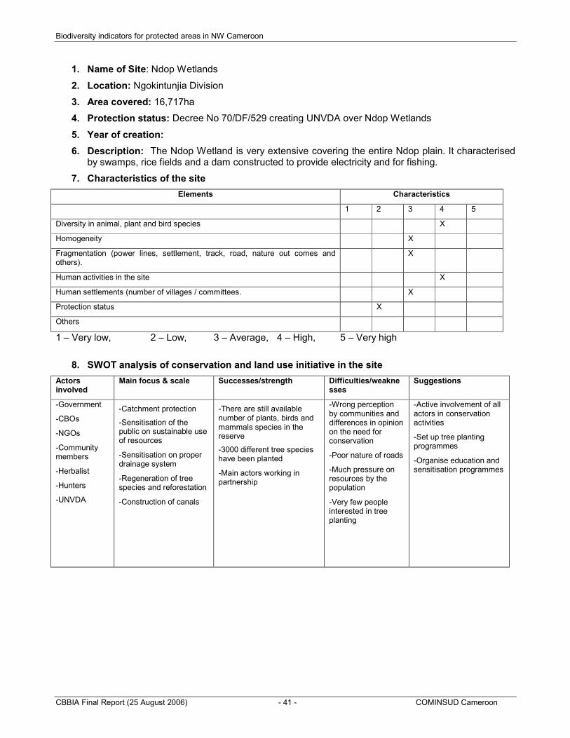
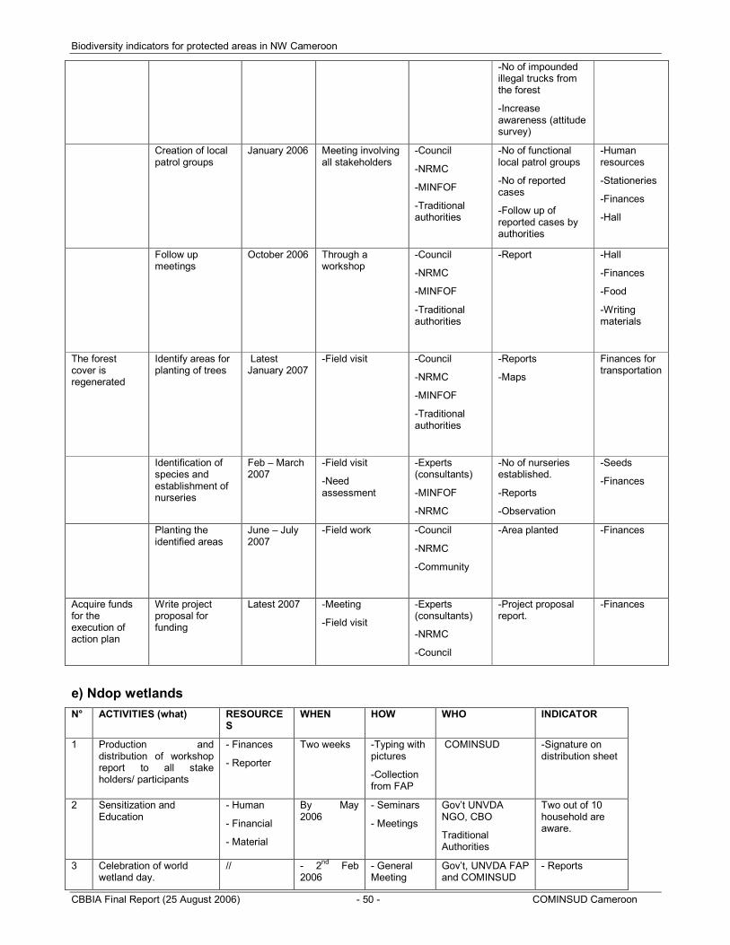
1. Name of Site: Ndop Wetlands
2. Location: Ngokintunjia Division
3. Area covered: 16,717ha
4. Protection status: Decree No 70/DF/529 creating UNVDA over Ndop Wetlands
5. Year of creation:
6. Description: The Ndop Wetland is very extensive covering the entire Ndop plain. It characterised by swamps, rice fields and a dam constructed to provide electricity and for fishing.
7. Characteristics of the site
Elements Characteristics
1 2 3 4 5
Diversity in animal, plant and bird species X
Homogeneity X
Fragmentation (power lines, settlement, track, road, nature out comes and others).
X
Human activities in the site X
Human settlements (number of villages / committees. X
Protection status X
Others
1 – Very low, 2 – Low, 3 – Average, 4 – High, 5 – Very high
8. SWOT analysis of conservation and land use initiative in the site
Actors involved
Main focus & scale Successes/strength Difficulties/weaknesses
Suggestions
-Government
-CBOs
-NGOs
-Community members
-Herbalist
-Hunters
-UNVDA
-Catchment protection
-Sensitisation of the public on sustainable use of resources
-Sensitisation on proper drainage system
-Regeneration of tree species and reforestation
-Construction of canals
-There are still available number of plants, birds and mammals species in the reserve
-3000 different tree species have been planted
-Main actors working in partnership
-Wrong perception by communities and differences in opinion on the need for conservation
-Poor nature of roads
-Much pressure on resources by the population
-Very few people interested in tree planting
-Active involvement of all actors in conservation activities
-Set up tree planting programmes
-Organise education and sensitisation programmes
Biodiversity indicators for protected areas in NW Cameroon
CBBIA Final Report (25 August 2006) - 42 - COMINSUD Cameroon