25
0 Developing Open Space Standards Guidance and framework greenspace scotland and Scottish Natural Heritage June 2013

0
Developing Open Space Standards Guidance and framework greenspace scotland and Scottish Natural Heritage June 2013

1
Executive Summary This web resource presents a framework for developing Open Space Standards which deliver quality, accessible and usable open space. The resource explores the reasons for developing the framework and then presents detail of the framework itself. The framework has been developed by a partnership made up of greenspace scotland, Scottish Natural Heritage, Dumfries and Galloway Council, Fife Council, Glasgow City Council, North Ayrshire Council and West Dunbartonshire Council. The framework is designed to give a common approach to standards development for all authorities but to be locally flexible thus allowing the context of any open space, or of any proposed development, to be taken into account. To do this, the proposed structure for local standards is made up of:
An accessibility standard defined in terms of a five minute walk to the nearest publicly usable open space
A quality standard defined as the minimum quality assessment score required from any new space and a target for managing all spaces
A quantity standard defined as the ‘ideal’ quantity of open space per 1000 people and allowing decisions to be taken on how much new space needs to be provided in any development
A series of settlement or neighbourhood descriptions
setting out the open space priorities at the local level and allowing interpretation of the other elements of the standard in terms of local context (what kind of new spaces need to be provided, which existing spaces are the priorities for action, where is accessibility an issue etc.)
The resource contains a number of examples of the framework in action and it is expected that further case studies will be added as use of the framework spreads. Note: The resource is supported by a supplementary report which describes the research project and methodology and the iterative approach used to develop the framework in more detail.1
1 greenspace scotland/Scottish Natural Heritage (2013)
Developing Open Space Standards Supplementary report. A combined report for SNH/greenspace scotland projects ref: 32040 and 47243
http://www.greenspacescotland.org.uk/greenspace-standards.aspx

2
Contents Page
Executive Summary 1
1. Introduction 3
1.1 Open space standards – policy context 3
1.2 What was wrong with existing standards? 5
1.3 Who are standards for? 6
1.4 Why develop a new approach now? 6
2. The Open Space Standards Framework 7
2.1 The accessibility standard 8
2.1.1 Using the accessibility standard 9
2.2 The quality standard 11
2.2.1 Using the quality standard 12
2.3 The quantity standard 13
2.3.1 Using the quantity standard 13
2.4 Incorporating typology-specific standards 14
2.5 Settlement or neighbourhood descriptions 15
2.5.1 Using the settlement/neighbourhood descriptions 16
3. Developing Open Space Standard for your area 17
3.1 Developing the standards 17
3.1.1 Getting started 17
3.1.2 Accessibility 17
3.1.3 Quality 17
3.1.4 Quantity 17
3.1.5 Where will the standards apply? 18
3.2 Testing the draft standards 18
3.3 Wider stakeholder engagement 20
3.4 Issues which need to be reconciled 20
3.4.1 Tensions between standards and typology-specific strategies 20
3.4.2 Incorporating standards into urban design led approaches 21
4. Looking forward – refining the framework model 22
Annex 1 Common themes for successful working 23
Annex 2 Sources of information 24
3
1. Introduction This resource provides local authorities and their partners with a framework for developing Open Space Standards. This project was developed as a result of a need identified in greenspace scotland/Scottish Natural Heritage research in 2010 which reviewed local authority practice on open space audits and strategies2. This scoping study found that many local authorities had not developed standards and were struggling to find an appropriate approach. The Open Space Standards Framework was developed and tested through two partnership research projects carried out between June 2010 and January 2013. The resulting Framework provides local authorities for the first time with a clear and robust methodology for developing locally appropriate open space standards. The testing conducted appears to demonstrate that the Framework will be flexible enough to cater for both urban and rural authorities. The project was led by greenspace scotland, with support from Scottish Natural Heritage and five local authorities. The five local authorities were recruited to provide a range of settings for developing and testing standards – urban vs rural; large vs small; within and outwith the Central Scotland Green Network area etc. In each local authority area, a team of officers was drawn together and these teams were tasked with the development and testing of ideas. The greenspace scotland role was to facilitate this process and to provide links to emerging ideas from across the project (allowing the authorities to learn from each other’s experiences). A number of other stakeholders provided valuable contributions throughout the project and at the expert seminar which reviewed the model. Project partners:
greenspace scotland
Scottish Natural Heritage (SNH)
Dumfries and Galloway Council
Fife Council
Glasgow City Council
North Ayrshire Council
West Dunbartonshire Council
1.1 Open space standards – policy context
Several iterations of Scottish Planning Policy, and supporting Planning Advice, have recommended that planning authorities develop Open Space Strategies which include Open Space Standards. Scottish Planning Policy requires all local authorities to develop a strategic approach to the planning and management of open space through the development of open space audits and strategies.3 It states that:
‘Local development plans or supplementary guidance should set out specific requirements for the provision of open space as part of new development and make clear how much, of what type and quality and what the accessibility requirements are. On and off site provision
2 greenspace scotland/Scottish Natural Heritage (2010) Open Space Audits and Strategies: Review of
Practice in Scotland http://www.greenspacescotland.org.uk/SharedFiles/Download.aspx?pageid=133&mid=129&fileid=52 3 Scottish Government (2010) Scottish Planning Policy
http://www.scotland.gov.uk/Publications/2010/02/03132605/12

4
should be considered, depending on the specific site circumstances. Planning authorities and developers should aim to create new open spaces which are fit for purpose, maintained and sustainable over the long term. They should be well designed, built to a high standard and capable of adaptation to reflect changes in the needs and requirements of users. Wherever possible, planning authorities and developers should identify opportunities to create and enhance networks between open spaces and avoid fragmentation. Planning authorities and developers should work together to ensure that proper arrangements are in place for the long term management of any proposed open space, landscaping and other common facilities.’
‘Open spaces should be accessible, safe, welcoming, appealing, distinctive and well connected. Within settlements there should be spaces that can be used by everyone regardless of age, gender or disability. Statutory equal opportunities obligations should be taken into account when planning for open space and physical activity. There are two main constraints on accessibility - physical constraints such as distance, degree of personal mobility and severance by roads, railways or other barriers, and social and cultural constraints such as fear of crime and other concerns over personal safety. These issues should be considered in the siting and design of open space. New open space and other facilities should be accessible on foot and bicycle and located where they can be served by public transport. Authorities are encouraged to improve access to existing areas of open space via green networks and paths.’
Scottish Government (2010) Scottish Planning Policy (paragraphs 154 and 155)
Planning Advice Note (PAN) 65 Planning and Open Space provides national planning guidance on open space strategies including the development of standards.4 It advocates a standards-based approach as part of the assessment and future planning of greenspace and states that:
“Standards should be carefully tailored to the circumstances of the area and a single standard will not be suitable for all parts of the country, even for all communities within the same local authority. Very different standards are also likely to be required for different functions such as play areas for children and teenagers and informal recreation areas”
Scottish Government (2008) Planning Advice Note 65: Planning and Open Space (paragraph 29)
The PAN identifies that standards should contain three elements: quality, quantity and accessibility.
4 Scottish Government (2008) Planning Advice Note 65: Planning and Open Space
http://www.scotland.gov.uk/Publications/2008/05/30100623/0

5
1.2 What was wrong with existing standards?
Open Space Standards have existed for some time in Local Development Plans and early Open Space Strategies. These were generally simple quantity standards aimed at new residential developments above a specific size and were presented as either a quantity of open space per 1000 people or per household. In some cases, further supplementary guidance covered the provision of specific types of open space (particularly equipped play facilities)5. These standards have been criticised for a number of reasons:
Existing standards seen as ‘inequitable’ or simply unrealistic Since the standard required the same amount of open space per household for every development with no reference to local context (such as the proximity of existing spaces) both planners and developers have questioned how realistic they are.
Many existing standards misused or misinterpreted national standards Looking across the range of standards that have been adopted, it is clear that many of them are based on Field’s In Trust’s Six Acre Standard.6 This standard was intended to apply only to outdoor sport and play and not to cover all other types of open space.
Many existing standards using figures developed elsewhere Similarly, there are a number of examples where consultants or council officers have used a more complex standard to address accessibility etc. but have simply used figures developed for other parts of the UK. In particular, standards developed for Greater London seem to have been used without any clear indication of whether they are relevant and applicable for Scottish local authority areas.
Concerns over the types of open space created in/by new developments Frequently, the open spaces created as a result of the existing standards do not contribute positively to the quality of the development. Often they are simply the areas of ‘bad land’ where building is not possible. These spaces are unlikely to meet local community needs and are, therefore, likely to fall into disuse and to become a drain on resources and a potential focus for anti-social behaviour. An allied problem is the over-provision of certain types of open space either as a result of planning policy promoting these typologies (for example, equipped play areas) or simply because they are easy to specify and cost (for example, Multi-Use Games Areas). In many local authority areas, we were told that there are too many equipped play areas and multi-use games areas for the user levels in the local population and that maintenance of these areas is becoming a problem simply due to their numbers.
Mismatch between what spaces are created and what can be managed At several stages of our research into Open Space Strategies (and Standards), we have been told by those responsible for managing open space that, when developments create new spaces, inadequate provision is made for the ongoing management of these spaces either through factoring arrangements, community management or through local authority management systems.
5 See Annex 1 for details of existing standards across Scottish Local Authorities
6 Fields In Trust (2008) Planning and Design for Outdoor Sport and Play
http://www.fieldsintrust.org/Product_Detail.aspx?productid=dc291578-50c5-49c5-b0d7-3c376db6b801

6
Problems with applying developer contributions One function of an Open Space Standard should be to justify the requirements for contributions from developers. This means that the combination of the Standard and the Open Space Strategy should clearly identify local priority actions to which developers can contribute. Existing standards rarely achieve this level of local detail.
They do not meet the requirements of Scottish Planning Policy For a combination of the reasons given above, existing standards generally fail to address the requirements stated in Scottish Planning Policy. They have little reference to offsite provision, quality and functionality of spaces, sustainability of management or connection to wider networks.
1.3 Who are standards for?
PAN65 guidance on Open Space Strategies makes it clear that these strategies are about more than Planning. They should also inform the management of open space resources by the local authority, communities and others. It, therefore, seems sensible that Open Space Standards should apply more widely than has been the case in the past. As well as providing a framework for Development Planners (and for developers and their design teams) looking at new residential developments, they should also apply to the management of existing spaces and to the creation of new spaces through routes other than housing development. They should create a ‘target’ for the accessibility, quality and overall provision of all open space. They should, if clearly expressed, also help communities and the politicians who represent them to understand their local open resource in the context of the wider Council area.
1.4 Why develop a new approach now?
A number of factors have come together to make this an appropriate time to develop a new approach to Open Space Standards.
Development planning Across Scotland, Planning Authorities are working on their Local Development Plans. Producing new Open Space Standards, either linked to Open Space Strategies or as Supplementary Guidance to the Local Development Plans, is an obvious extension to this process.
Emerging green network thinking Increasingly, Planning Authorities are working towards the creation of functional green networks. This is particularly advanced in Central Scotland as a result of the Scottish Government’s commitment, in National Planning Framework 2, to the creation of a Central Scotland Green Network.7 This network thinking adds greatly to the available information and policy commitments to underpin Open Space Standards.
Improved data on open space The publication of Scotland’s Greenspace Map, in 2011, means that there is now a consistent dataset for open space quantity and distribution for all urban areas in Scotland.8 Datasets available from Ordnance Survey allow easier mapping of access routes and accessibility and more local authorities have (or are collating) data on open space quality
7 Scottish Government (2009) National Planning Framework for Scotland 2
http://www.scotland.gov.uk/Publications/2009/07/02105627/0 8http://www.greenspacescotland.org.uk/scotlands-greenspace-map.aspx

7
and greenspace access points. At the same time, GIS software packages now allow network analysis of walking routes from individual houses to their nearest greenspace – something which was unfeasible or technically challenging in the early days of open space mapping. These combine to make the development of a locally applicable standard easier than it has been in the past.
2. The Open Space Standards Framework This section outlines the way in which Open Space Standards are structured and how they work within this Framework. The following section gives more detail on how they should be developed at the local level. It should be noted that this framework presents the Standards in a different sequence to that implied by PAN65. Research relating to the economic and social benefits of open space9 shows that it is the very local spaces (and their quality) which has the greatest impact on quality of life and to the ongoing success of neighbourhoods as places. For this reason, we have chosen to present the standards in the following sequence:
(1) Accessibility
(2) Quality
(3) Quantity The standard has two components. The first sets a vision for the open space resource across the whole area under consideration (the ‘Council-wide Standard’). This covers accessibility, quality and quantity. In some cases, where settlements or neighbourhoods are dramatically different then it may be necessary to have more than one standard within a Planning Authority area. For example, in Glasgow we are exploring the best combination of standards – at present this looks likely to require three separate quantity standards: one for the city centre; one for most of the rest of the city and a third for the urban fringe. The second component of the standard sets local context and allows for more flexibility in interpreting the standard. This ‘local context’ involves the use of the Quantity Standard and detailed descriptors outlining key local priorities.
9 See http://www.greenspacescotland.org.uk/SharedFiles/Download.aspx?pageid=133&mid=129&fileid=95 for
further information on greenspace and quality of life research

8
2.1 The accessibility standard
The accessibility standard refers to how close people should be to their nearest publicly usable open space (see below for definition). Whether a space is ‘publicly usable’ depends on two factors: the type of space and the size of space – is it big enough to be usable?
What are ‘publicly usable open space typologies?
Public Parks and Gardens
Amenity Greenspace - Residential
Playspace for Children and Teenagers
Playing Fields
Green Corridors
Natural/Semi Natural Greenspace
Allotments & Community Growing Spaces
Civic Space
This definition of publicly usable space was developed and tested by the project partners. It is based on the PAN65 open space typology but all ‘non-usable’ typologies (such as amenity space associated with transport routes) have been removed. It relates closely with the emerging work on developing a national SOA indicator for accessible greenspace which uses the same typologies with the exception of Civic Space and Allotments/Community Growing Spaces. It should be noted that in individual cases, there will be spaces which fall into a different Open Space typology but are still ‘publicly usable’ – for example, some (but not all) school and institutional grounds will provide public access and use. These cases should be highlighted in the appropriate settlement description and allowances made for these specific spaces in any analysis of local provision and need.
The accessibility standard is:
Everyone will live within a 5 minute walk of a publicly usable open space of at least 0.2 hectares in size
International research into the impacts of greenspace on health and on wider quality of life shows that having greenspace within a 5 minute walk of home is a strong indicator for health and quality of life benefits10. 0.2 hectares is big enough for a ‘kick about’ pitch or other informal play (and also has the advantage that it is also the minimum size of open space which has been audited in many areas). Generally, in urban design, a 5 minute walk is considered to equate to a distance of 400 metres ‘door to space’. It is possible to approximate this by setting the standard as an ‘as the crow flies’ (or Euclidean) buffer set at 75% of the walking distance (i.e. 300metres). This approach is not particularly accurate especially if there are roads or other barriers to access. Current GIS software can assess walking distance using streets and paths to give a more accurate assessment of accessibility on the basis of ‘network analysis’. For network
10
See http://www.greenspacescotland.org.uk/SharedFiles/Download.aspx?pageid=133&mid=129&fileid=95 for further information on greenspace and quality of life research

9
analysis to be possible, data on the access points to open spaces is also required. Where such data is not immediately available, the Central Scotland Green Network Pedestrian Accessibility of Urban Greenspace Pilot11 provides a model for generating access point data and running network analysis using this derived data. It should be noted that several of the authorities involved in this research have adopted, or are considering, a shorter distance to represent a 5 minute walk. This is because they have identified that some of the primary users of open space may not be able to walk 400 metres in 5 minutes. In Fife, they have selected a distance of 250 metres as this is more realistic for families with young children. A similar distance is under consideration in Dumfries and Galloway in recognition of the fact that the area has an ageing population. (See 3.1.2 for further discussion about how to determine what constitutes a 5 minute walk and how to agree the minimum size of open space.) 2.1.1 Using the accessibility standard
When applying the accessibility standard to the existing open space resource, it is possible to identify those areas which do not meet the standard. In these areas, creation of new spaces (and/or improved access to existing spaces) is a priority. Any new development in such an area would be required to provide accessible open space or to create better links to existing spaces if they are nearby. Any resources available for open space (whether from developer contributions or other sources) should be applied to addressing the accessibility shortfall. Where a development (residential or otherwise) reduces accessibility to open space for neighbouring areas, this must be factored into the design to ensure that the accessibility standard continues to be met. In some circumstances, a simple access solution may dramatically reduce the amount of open space needed to meet the accessibility standard (see case study 1).
Note: the accessibility standard overrides the quantity standard. In circumstances where a settlement or neighbourhood has a relatively high level of open space but some houses do not meet the accessibility standard this must be addressed (see case study 2).
11
Link to be added when available
10
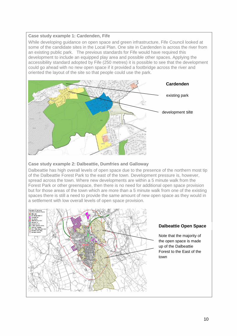
Case study example 1: Cardenden, Fife
While developing guidance on open space and green infrastructure, Fife Council looked at some of the candidate sites in the Local Plan. One site in Cardenden is across the river from an existing public park. The previous standards for Fife would have required this development to include an equipped play area and possible other spaces. Applying the accessibility standard adopted by Fife (250 metres) it is possible to see that the development could go ahead with no new open space if it provided a footbridge across the river and oriented the layout of the site so that people could use the park.
Case study example 2: Dalbeattie, Dumfries and Galloway
Dalbeattie has high overall levels of open space due to the presence of the northern most tip of the Dalbeattie Forest Park to the east of the town. Development pressure is, however, spread across the town. Where new developments are within a 5 minute walk from the Forest Park or other greenspace, then there is no need for additional open space provision but for those areas of the town which are more than a 5 minute walk from one of the existing spaces there is still a need to provide the same amount of new open space as they would in a settlement with low overall levels of open space provision.
existing park
development site
Dalbeattie Open Space
Note that the majority of
the open space is made
up of the Dalbeattie
Forest to the East of the
town
Cardenden

11
2.2 The quality standard
The quality standard is:
All publicly usable open spaces will score ‘good’ or better on the locally used quality assessment Open Space quality is assessed in a number of different ways by Scottish local authorities.12 These can be summarised as follows:
greenspace scotland/Glasgow and Clyde Valley Green Network Partnership guidance13
Green Flag Award Scheme14
Land Audit Management System (LAMS)15
In-house approaches (various)
Consultant-generated approaches (various) These approaches differ in the range of spaces and typologies covered and the criteria assessed, but all typically involve a rating of individual spaces against a numeric scale (0-4 or 0-5) or an equivalent quality scale (poor to good or poor to excellent). In the absence of a standardised approach to quality assessment the quality standard is set as a threshold score which is equivalent to the two highest categories based on whichever quality assessment approach is being used. Generally this will equate to a threshold somewhere between 60 and 70%.This level equates to a Green Flag Award Scheme pass score (66%) where local authorities are using Green Flag as an internal auditing system. In many areas, there is a commitment to increasing multi-functionality of spaces to maximise their contribution to quality of place and the benefits that they provide to local communities. Increasingly, there is also a commitment to incorporate green infrastructure functions, such as water management, into new and existing open spaces. These aspirations are also included in Scottish Planning Policy. It may, therefore, be desirable to incorporate these concepts into the quality standard (see case study example 3). Case study example 3: Glasgow’s draft quality standard
All open spaces (new and existing) will score at least 60% on the quality scale. All spaces should, wherever possible, be multi-functional and contribute to local green networks and surface water management priorities. (See section 3.2 for a discussion of how to ‘ground truth’ the chosen quality standard.)
12
More information about the approaches adopted by specific local authorities can be found in greenspace scotland/Scottish Natural Heritage (2010) Open Space Audits and Strategies: Review of Practice in Scotland http://www.greenspacescotland.org.uk/SharedFiles/Download.aspx?pageid=133&mid=129&fileid=52 13
greenspace scotland/Glasgow and Clyde Valley Green Network Partnership (2008) Greenspace quality – a guide to assessment, planning and strategic development http://www.greenspacescotland.org.uk/SharedFiles/Download.aspx?pageid=133&mid=129&fileid=53 14
http://greenflag.keepbritaintidy.org/ 15
http://www.apse.org.uk/direct-news/09/mar-apr/Local-environmental-audit-management-systems.pdf
12
2.2.1 Using the quality standard
The quality standard has two main uses.
Existing spaces Applying it to the existing open space resource allows you to identify where investment is needed to bring spaces up to the standard. This can be built into the management priorities for specific spaces and can also be used to target investment from developer contributions. In some cases, where spaces are scoring well below the standard, there may be a need to review what this space is being used for and whether it might be better managed for some other function.
New spaces Where new spaces are created by Councils, communities or developers, these must meet the quality standard and have arrangements in place to ensure that this quality is sustained over time.

13
2.3 The quantity standard
This element of the standard begins to allow for local context. It is an agreed quantity of publicly usable open space per household against which individual settlements or neighbourhoods can be compared. This allows a different set of actions to be taken depending on whether the area under consideration has more or less publicly usable open space than the Council-wide Standard. The Quantity Standard is expressed in terms of hectares of open space per 1000 population or metres2 per household. The Quantity Standard is:
All settlements/neighbourhoods should have X hectares of publicly usable open space per 1000 people (or Ym2 per household) – where X or Y is locally derived. The figure selected must be realistic at a local level and, as mentioned above, it may in some circumstances be necessary to have more than one quantity standard to reflect differing types of settlement. 2.3.1 Using the quantity standard
There are two main uses for the quantity standard:
Existing spaces Applying it to the existing open space resource allows planners and greenspace managers to identify areas of surplus (where it may be possible to use some of the lower quality spaces in another way) and of deficit where the creation of publicly usable open space is a priority.
New spaces Where a development (above an agreed minimum number of units) is proposed in an area that has less publicly usable open space than the quantity standard, then the developer will be required to provide open space within the development equivalent to the quantity standard (whilst also meeting the accessibility and quality standards). Where the development is in an area which has more publicly usable open space than the quality standard, then it is only necessary for the developer to ensure that the accessibility standard is met (and that any new spaces that this requires meet the quality standard) – see case study example 4. Case study example 4:
If the local quantity standard has been set at 5ha per 1000 people, then a housing development in an area where the existing open space provision is only 3 hectares per 1000 people will be required to provide the equivalent of 5 ha per 1000 and to ensure that these spaces meet the quality standard (with management arrangements in place) and that all houses are within a 5 minute walk of a usable space.
If the development is in an area with 7ha per 1000 people (i.e. exceeds the quantity standard), then it will be necessary to ensure that all houses are within a 5 minute walk of a usable space. This may involve the creation of some new spaces – where this is the case, these spaces must meet the quality standard (including management arrangements). In these circumstances the focus will be on the accessibility and quality of spaces locally and developer contributions for the management of these spaces. It should be noted that it is possible to increase the amount of publicly usable space in an area by ensuring that ‘unusable’ open space typologies become more usable. This could

14
include the creation of multi-functional sustainable drainage systems (which – if single function – will be mapped as ‘other functional space’) or of streets which function as civic spaces for people rather than as roads for traffic. In some cases it might simply be about ensuring that school grounds, for example, are (and stay) accessible for public use. These new publicly usable spaces can then be recognised in the appropriate settlement/
neighbourhood description.
2.4 Incorporating typology-specific standards into the Council-wide standard
Where standards exist, or guidance has been adopted, relating to specific open space typologies, this will also apply. This includes national standards/guidance or locally devised and adopted standards. It may include:
accessibility – for example, distance thresholds for travel to sports facilities or public parks types within a park hierarchy for example
quality – for example, detailed design and safety criteria for play provision or design guidance for allotments
quantity – for example, provision levels for community growing or recreational provision per 1000 people.
There may also be local commitments to greater access connectivity or habitat networks. In each case, if there is an existing local commitment to provision levels/quantity, quality or accessibility for any open space typology then this will apply in addition to the Open Space Standards (which are in effect a minimum requirement). These additional requirements can be fully explored and interpreted in the settlement or neighbourhood description.

15
2.5 Settlement or neighbourhood descriptions
This is the most important element of the standards framework because it gives local context and meaning to the standards. The inclusion of summaries of local open space provision and priorities for action is not uncommon in Open Space Strategies (the supplementary report includes examples from Fife and from Stirling) but they have not generally been linked to standards. To allow planners and others to interpret what the standard means in specific areas, the framework includes a description for each settlement (see case study example 5). Case study example 5: Typical contents for a neighbourhood description
Settlement name:
Population level:
Brief description of local context:
(e.g. relevant local history, key facilities, local landscape priorities, SIMD and other development/regeneration priorities etc.)
Short description of current open space provision:
overall quantity of publicly usable spaces (and comparison to the quantity standard)
list of the main publicly usable open spaces (and their quality scores)
assessment of the accessibility of public spaces (how many/which houses are outwith the agreed accessibility threshold)
Breakdown of open space provision
typologies which are under/over-represented
identified local need (including reference to typology specific provision/accessibility requirements from other strategies)
Opportunities Plan - priorities for action (and investment)
accessibility challenges (can the standard be met by creating new access points and connections?)
quality shortfalls in existing spaces
need/potential for green infrastructure and enhanced green networks
missing typologies (to meet local need)
Maps of settlement
current extent
identified development areas (if any)
current publicly usable open space
opportunities
For more urban authorities such as Dundee, Edinburgh and Glasgow (and for larger settlement areas in other authorities) it may be necessary to use another ‘geography’ to divide the area. This requires a locally acceptable definition of neighbourhoods (see case study example 6).

16
Case study example 6: Glasgow’s neighbourhood descriptions
In Glasgow, the neighbourhood descriptors have been developed at a Council Ward level. This is the most logical political division of the City. It does, however, bring added complications which must be addressed in the descriptions. For example, in many parts of the City, open space facilities used by communities will actually lie in neighbouring wards. The description of the open space resources and the assessment of their accessibility must, therefore, include spaces which are outwith the ward boundary and a full exploration of the cross-ward open space links (spaces in neighbouring wards which provide open space access for this ward or vice versa). Where individual settlements or neighbourhoods are obviously heterogeneous, with very different open space resources in different areas, this can be addressed in the description with each area and its priorities described separately. 2.5.1 Using the settlement/neighbourhood descriptions
The descriptions allow much more detailed decisions to be made regarding:
management and investment priorities for existing open spaces
provision of new spaces For example, where a new development is proposed, the relevant description can be consulted and this will give the local context necessary to determine:
1. where action is needed to increase accessibility to publicly usable open space
2. where developer contributions might be applied to increasing the quality of key open spaces
3. what types of open space should be provided to meet the quality standard
4. what opportunities exist to make currently ‘unusable’ open spaces into publicly usable spaces
Similarly, if action is proposed to enhance the green network, the descriptions will show the key areas where interventions are needed to increase connectivity and/or to improve multi-functionality of spaces.
17
3. Developing Open Space Standards for your area The process of developing workable Open Space Standards for your area is based on two key approaches. The first is stakeholder involvement and the second is iterative testing of the standards proposals against the open space data that is available locally. To be of value, Open Space Standards must be challenging but achievable. They should be about making the resource better but they must also be pragmatic. If standards are seen to be unrealistic then they will tend to be disregarded and so devalued.
3.1 Developing the standards
3.1.1 Getting started
At this stage, the standards development process should involve a working group representing planners, greenspace managers and other key interests (urban design, health promotion etc.). This group should be small enough to be able to meet regularly and to take initial decisions. The draft standards developed by this group will be tested with a wider range of stakeholders later in the process. 3.1.2 Accessibility
The first step in developing the accessibility (and indeed the quantity) standard is to agree locally what is to be classed as publicly usable open space. The guidance in section 2.1 outlines the publicly usable PAN65 typologies. But it should be noted that there may be individual spaces from the excluded typologies which should be included in the calculation of standards (for example, institutional grounds which are publicly usable such as the university campus in Stirling). The next step is to agree locally what constitutes a 5 minute walk. This is about agreeing who the ‘target audience’ is for open space use. If you are particularly interested in promoting use by ‘less mobile’ groups then the distance threshold selected should be lower than 400m. If this is not a key priority, then the 400m distance should be used. Thirdly, it is necessary to agree what the minimum size for a publicly usable open space should be. This will be determined, in part, by the uses that you would envisage local spaces having and, in part, by an understanding of the existing types and sizes of spaces across your area. 3.1.3 Quality
The main process in developing the quality standard is looking at the audit/assessment approach that is in use locally and selecting the score which is to be used as the quality standard – i.e. the scores that represents ‘good’. In some areas, quality audits have been carried out using a methodology which gives different scoring ranges for different open space typologies. In these circumstances, it is necessary either to have a different quality score set as the standard for each typology or to create a mechanism for making the different typology scores directly comparable. 3.1.4 Quantity
To be workable, the quantity standard needs to be based on existing open space provision. Simply selecting a quantity standard developed elsewhere is unlikely to be successful. The starting point for developing the quantity standard, therefore, is to extract data from the Scotland’s Greenspace Map and/or local datasets to identify how much publicly usable open

18
space is available in and around each settlement or neighbourhood (using a 500m buffer for settlements). Since the quantity standard is mainly used to identify whether a specific area is above or below the standard and to determine what action is therefore needed, the obvious place to start is with the average provision per settlement/neighbourhood. We would recommend using the median quantity to avoid extremes having too much of an impact. 3.1.5 Where will the standards apply?
It is also important at this stage to determine the minimum size of development that the standards will be applied to. This may already be laid out in the Local Development Plan or associated guidance (see case study example 7) Case study example 7: Minimum size of development for applying the standards
In Dumfries and Galloway, there is considerable concern about the impact of small scale incremental development around the edges of smaller settlements. The Council has, therefore, decided that the standards will apply to all housing developments which will, either individually or through phasing, result in the development of 5 or more units.
3.2 Testing the draft standards
The draft figures need to be tested against reality. For accessibility and quantity, this is done by running the proposed standards against the GIS datasets for the area to see whether the figures can realistically be achieved. It is also helpful to check the implications of the draft figures for any candidate sites in the Local Development Plan and for existing urban design guidance/masterplans for specific areas etc. Where the draft accessibility standard is considered to be unworkable there are two options available. If the draft uses a distance less than 400m then it is possible to increase that distance up to 400m (but no higher). The other option is to reduce the minimum size of open space that is deemed to be publicly usable. In either case, it is important to test several options to ensure that the best and most practical solution is found (see case study example 8). Case study example 8: Testing accessibility standards in Fife
Fife’s original draft accessibility standard was 250 metres to a publicly usable space of 0.2 hectares. When this was considered in light of the Urban Design priorities for Fife’s towns, this figure was deemed to be too prescriptive and to exclude the value of ‘high place quality streets’ and small pocket greenspaces. In light of this, the standard was revised to 250 metres to a publicly usable space of 0.1 hectares. Where the draft quantity figure is considered to be unworkable, there are a number of options. If the draft standard is unworkable across most areas, then a number of alternative standards should be tested until a workable option is found (see case study example 9).

19
Case study example 9: An iterative approach to developing quantity standards in West
Dunbartonshire
The consultants who had previously worked on the West Dunbartonshire audit and strategy had agreed a division of the urban areas in West Dunbartonshire as follows: Clydebank; Dumbarton; Vale of Leven; Milton and Bowling.
This division was used as a basis for the initial development of a quantity standard. It soon became evident that the Milton and Bowling data was very different to the others and that including this data made the development of a standard very difficult. Milton and Bowling are, in effect, two small settlements joined by a large ex-industrial site with limited public access. This means that their levels of open space per 1000 population are much higher than the truly urban areas (between 3 and 7 times higher than their neighbours and 2.5 times higher than the highest levels in Fife or North Ayrshire).
Including Milton and Bowling gave an average open space provision which was unachievable in the other urban areas (and in fact could only be matched authorities by new towns such as Glenrothes). The decision was taken to remove Milton and Bowling from the analysis and the figures were recalculated. The new average figure was 8ha per 1000 people. This was then tested against the mapping of Clydebank, Dumbarton and Vale of Leven. The GIS analysis showed that this quantity standard would be challenging in Dumbarton and Vale of Leven but might prove impossible to achieve in Clydebank. Using this figure in Clydebank would force all development to the urban fringes.
The decision was taken to seek internal views from planning and development colleagues on a series of quantity standards (6, 7 and 8ha per 1000 people) or on whether Clydebank needed a separate standard which acknowledged its more urban nature and focused more on smaller, high quality public spaces. This discussion was presented as part of the issues paper developed for internal consultation.
If the figure works in most places but is unworkable in one particular type of settlement or neighbourhood, then it may be necessary to have more than one quantity standard (see case study example 10). Case study example 10: Area specific quantity standards in Glasgow
Glasgow is likely to adopt three quantity standards: one for the city centre, one for the majority of the city and a third for urban fringe areas. The urban fringe standard is still under discussion because these areas typically have large amounts of low quality, functionless spaces. The working group is looking at the Urban Design priorities for these areas to see what the quantity standard should be.
If there are only a few specific settlements or neighbourhoods that cannot sensibly meet the standard (for example, due to local landform) then alternative strategies for these specific areas can be addressed in the relevant settlement/neighbourhood description (see case study example 11) Case study example 11: Settlement specific quantity standards in Dumfries and Galloway
Eastriggs in Dumfries and Galloway is tightly constrained by road and railway and has few opportunities for open space creation. Rather than reduce the overall quantity standard, this will be discussed in the settlement description for Eastriggs and reflected in the ways that future development is planned.

20
3.3 Wider stakeholder engagement
Since the Open Space Standards will form part of either the Open Space Strategy or separate Supplementary Guidance, there will be a need for formal consultation before they can be adopted. It is advisable to test the proposed standards, and the underlying rationale for the their development, with a wider stakeholder group before finalising the standards and taking them to Committee. This should include a wider group of relevant local authority officers (i.e. some who have not been involved in the development of the standards) and also representatives of communities and developers (if this is possible). This should be done at the stage when all the elements of the standard have been agreed by the working group and tested against the data. It is important that the settlement/ neighbourhood descriptions are included in this stakeholder engagement since these will make the standards much easier to understand and interpret. It may also be helpful to check that communities are comfortable with the content of the settlement/neighbourhood accounts at this stage.
3.4 Issues which need to be reconciled at a local level when developing standards
3.4.1 Tensions between standards and typology-specific strategies
Although the framework model expressly recognises typology-specific standards for accessibility, quality and quantity and indicates that these will apply in addition to the Open Space Standards, there are still circumstances in which the two sets of standards may not be completely compatible. In each case, a local decision is needed to determine how this tension will be addressed; this should be reflected in the settlement/neighbourhood descriptions wherever the tension arises.
Sports pitches A number of stakeholders involved in the development of the framework highlighted concerns over the potential tension between sports pitch provision and other types of open space. Strategic assessment of sports pitch provision is based on sportscotland’s guidance ‘Guide to the preparation of sports pitch strategies’, this sets out the stages to be followed in developing Pitch Strategies, and involves considering the supply and demand for these spaces. Use of the guidance can highlight whether there is over provision of pitches for current and future demand. Where this is the case, and where there are no quality or capacity uses at remaining pitches which would require investment to compensate for the loss of pitches, then consideration would need to be given as to the on-going use of the areas, i.e. remain as open space or receipts from a sale used to address other priorities identified in the Open Space Strategy. The reality reported to us is that this link to the wider Open Space Strategy can be missed with an associated loss of multi-functional spaces. It is essential, therefore, that all decisions on sports pitch provision must be considered as part of the Pitch Strategy with reference to the Open Space Strategy and in line with the relevant settlement/neighbourhood description ‘opportunities’ section.

21
Typologies with specific site requirements The second potential tension arises from the fact that some open space typologies have very specific site requirements. For example, long-term community growing is really only practical on sites with suitable aspect and soil conditions. Similarly, the creation of new spaces within a wider habitat network will have constraints relating to site condition (e.g. wildflower meadows requiring low fertility soils) and they must be located to link to the existing network. Where suitable sites exist, a decision is needed on whether these will be retained for the specific use to which they are best suited. This can be identified in the opportunities section of the settlement/ neighbourhood account. 3.4.2 Incorporating standards into Urban Design led approaches
The Scottish Planning Policy/PAN 65 position on standards initially seems to be at odds with the design-led approaches advocated in Scottish Government policy statements such as Designing Places and Designing Streets.1617 These promote place-sensitive solutions which are designed to be flexible and to adapt to changing conditions. A standards based approach would appear to be too inflexible to be compatible with this thinking – indeed many of the earlier open space standards have been implicated in the creation of poor spaces and developments with little sense of place. There are a number of solutions to this apparent conflict:
Use local design priorities to set standards It is possible to use local design priorities to set the standards for particular areas. For example, in Fife, the minimum size of publicly usable space was adjusted to recognise that Urban Design approaches were creating quality spaces on a smaller scale that were having a genuine impact on quality of place. In Glasgow, the long term Urban Design priorities for peripheral housing areas are being used to ensure that the quantity standard adopted for these areas can produce a better ‘place’ solution.
Recognise design priorities for streets and green infrastructure By recognising the design priority for streets and for multi-functional green infrastructure (e.g. sustainable drainage features which also provide public space), it is possible to create a degree of flexibility in terms of the standard. In these cases, the neighbourhood description can highlight the opportunity to include, for example, green roofs or rain gardens in the open space provision.
Different quality standards for specific areas It is possible to have a number of different quantity standards within the model and so this means that different options can be made available in specific areas such as City Centres where design-led approaches suggest a different solution is needed.
16
Scottish Government (2001) Designing Places http://www.scotland.gov.uk/Resource/Doc/212607/0099824.pdf 17
Scottish Government (2010) Designing Streets http://www.scotland.gov.uk/Publications/2010/03/22120652/0
22
4. Looking forward – refining the framework model The project partners feel that this framework presents a workable methodology for developing locally flexible open space standards that will help to deliver quality, accessible and usable open spaces. It must be recognised, however, that as the partner authorities’ standards and guidance are tested in response to development applications or resource allocation decisions there is much that we will learn about the framework’s effectiveness. It may also be that, as more authorities use the framework we will be able to identify areas where there is a need for revisions or clarification. With this in mind, we expect that this resource will require some form of update in the future and greenspace scotland and Scottish Natural Heritage would welcome any feedback on your experience of using the framework in your local area. June 2013

23
Annex 1 Common themes for successful working Key staff involvement
It is important that the standards development process involves knowledgeable staff from both planning and greenspace management and also someone with technical GIS skills. Not all these people have to be involved in every stage of the process but they need to be available for comment and/or analysis of data. For this to be successful, there needs to be a designated project leader who can call colleagues into the process as and when they are required (this may need to be a fairly senior member of staff).
Wider internal communications and consultation
It is important that any emerging standards are tested against the knowledge and views of colleagues who will apply, use and deliver them. This is an important part of the iterative testing and is both an opportunity for ground-truthing the standard (checking it will work in the real world) and for picking up any aspects of the standards where there is a risk of ambiguity or misinterpretation (particularly where planners and developers are working under resource constraints and there may be a pressure to ‘cut corners’). It is particularly important that relevant officers with good local knowledge are engaged in the development of the settlement accounts (see section 4.3.5).
Discussions with stakeholders
Beyond this internal communication and consultation there is a need to expose the draft standards to public scrutiny and this was built into the process in each of the areas. An opportunity also exists to discuss the standard with key external stakeholders (developers, community representatives, regional green network partners, national agencies etc.) during the development process. For example, the chance to discuss the emerging standards with representatives from the development industry and with organisations involved in the Lochgelly Sustainable Communities project was very useful in the Fife context for example

24
Annex 2 Sources of information relating to open space standards
greenspace scotland research and guidance
Supplementary report on Developing Open Space Standards (2013)
http://www.greenspacescotland.org.uk/greenspace-standards.aspx
Interim report on Developing Open Space Standards (2012) This includes more detail on phase 1 of the action research project on standards http://www.greenspacescotland.org.uk/SharedFiles/Download.aspx?pageid=133&mid=129&fileid=277
Review of Open Space Audits and Strategies (2010) http://www.greenspacescotland.org.uk/SharedFiles/Download.aspx?pageid=133&mid=129&fileid=52
Scottish Government policy and guidance
Scottish Planning Policy (2010) http://www.scotland.gov.uk/Publications/2010/02/03132605/0
Planning Advice Note 65 – Planning and Open Space (2008) http://www.scotland.gov.uk/Publications/2008/05/30100623/0
Minimum Standards for Open Space Research Report (2005) http://www.scotland.gov.uk/Publications/2005/07/18104215/42175
Designing Places (2001) http://www.scotland.gov.uk/Resource/Doc/212607/0099824.pdf
Designing Streets (2010) http://www.scotland.gov.uk/Publications/2010/03/22120652/0
4.3 Guidance from specialist and typology specific organisations
4.3.1 sportscotland http://www.sportscotland.org.uk/
Guide to the preparation of pitches strategies (2004) http://www.sportscotland.org.uk/resources/Facilities/Planning/Guide_to_the_preparation_of_sports_pitch_strategies
4.3.2 Fields in Trust http://www.fieldsintrust.org/
Planning and design for outdoor sport and play (includes the ‘6 acre standard’) http://www.fieldsintrust.org/Product_Detail.aspx?productid=dc291578-50c5-49c5-b0d7-3c376db6b801
4.3.3 Scottish Allotments and Gardens Society http://www.sags.org.uk/
4.4 Outputs from standards development process with participating Councils
Fife Council Supplementary Guidance on Green Infrastructure (weblink to be added when available)
West Dunbartonshire Local Development Plan Main Issues Report http://www.west-dunbarton.gov.uk/media/809768/main_issues_report_web.pdf


