59
______________________________ DEVELOPMENT CONTROL PLAN Multi-unit housing _____________________________

______________________________ DEVELOPMENT CONTROL PLAN
Multi-unit housing
_____________________________

Multi-Unit Housing Development Control Plan
Randwick City Council
2
Updates:
• 09/05/2003 – (LEP Amendment No. 23). The LEP definition of ‘Gross Floor Area’ was amended.

Multi-Unit Housing Development Control Plan
Randwick City Council
3
CONTENTS Part 1 GENERAL INFORMATION .................................................................................5
1.1 Introduction and Aims ..................................................................................................................... 6 1.2 How to use this Development Control Plan..................................................................................... 7 1.3 Requirements for the Submission of a Development Application.................................................... 8 1.4 Assessment of Applications ............................................................................................................ 8
Part 2 DEVELOPMENT CONTEXT – A Vision for Randwick......................................9 2.1 A Vision for Randwick - Desired Future Character........................................................................ 11
Part 3 BUILDING DESIGN ...........................................................................................25 3.1 Site Planning................................................................................................................................. 26 3.2 Height ........................................................................................................................................... 28 3.3 Building Setbacks ......................................................................................................................... 29 3.4 Density .......................................................................................................................................... 31 3.5 Fences .......................................................................................................................................... 32
Part 4 ENVIRONMENTAL DESIGN .............................................................................33
4.1 Landscaping and Private Open Space.......................................................................................... 34 4.2 Privacy .......................................................................................................................................... 36 4.3 View sharing ................................................................................................................................. 38 4.4 Solar Access and Energy Efficiency ............................................................................................. 39 4.5 Safety and Security....................................................................................................................... 41
Part 5 FACILITIES AND ACCESS...............................................................................42 5.1 Parking.......................................................................................................................................... 43 5.2 Driveways and Manoeuvring Areas .............................................................................................. 45 5.3 Storage ......................................................................................................................................... 46 5.4 Barrier-free Access ...................................................................................................................... 47 5.5 Utilities/Site Facilities .................................................................................................................... 48 5.6 Waste Minimisation and Management…………………………………………………………….…….49
Part 6 AREAS OF SPECIAL SIGNIFICANCE .............................................................50
6.1 Heritage Conservation Areas and/or Heritage Items ................................................................... 51
6.2 Foreshore Scenic Protection Areas .............................................................................................. 53
6.3 Coral Sea Park Estate…………….……………………………………………………………………...55
6.4 Mons Avenue Site.……………….……………………….………………………….…………..…….…57

Multi-Unit Housing Development Control Plan
Randwick City Council
4

Multi-Unit Housing Development Control Plan
Randwick City Council
5
Part 1
GENERAL INFORMATION
Multi-Unit Housing Development Control Plan
Randwick City Council
6
1.1 INTRODUCTION AND AIMS
This development control plan (DCP) has been prepared in accordance with the provisions of the Environmental Planning and Assessment Act 1979 and the Environmental Planning and Assessment Regulation 1994.
The DCP applies to all land within the City of Randwick that is zoned Residential 2B and 2C. It supplements Randwick Local Environmental Plan 1998 (LEP) and contains detailed development controls, standards and guidelines for multi-unit housing development in these zones.
The aims of this DCP are to:
1. Achieve Residential Diversity
• encourage the provision of a varied residential environment which responds to the increasing diversity of household sizes and types;
• ensure multi-unit housing is sensitive to the local environment and makes better use of existing infrastructure and is capable of adapting to meet the needs of people with a disability;
• encourage the provision of housing that is accessible and adaptable to meet the existing and future needs of all households, including people with disabilities.
2. Encourage Urban Design Excellence
• encourage environmental and architectural design excellence to produce an urban environment which inspire the community;
• promote environmental design standards which respect and enhance the desired character of existing neighbourhoods;
3. Ensure Neighbourhood Amenity
• enhance the quality and safety of the physical environment of Randwick;
• minimise adverse impacts of development on surrounding land, including the loss of amenity;
4. Implement Ecological Sustainability
• implement the principles of ecologically sustainable development;
• encourage the use of energy efficient design techniques;
5. Provide Clear and Consistent Controls
• provide clear and concise design guidelines and development standards.

Multi-Unit Housing Development Control Plan
Randwick City Council
7
1.1 HOW TO USE THIS DEVELOPMENT
CONTROL PLAN
This DCP has 6 parts.
- Part 1 - General Information
• explains the purpose and structure of the DCP and how it is to be used.
• lists matters that must be addressed when a Development Application is submitted.
• notes how applications will be assessed.
Part 2 – “A Vision for Randwick”
• outlines the 7 main residential building types which
characterise the area and provides guidelines for infill
development.
Parts 3,4, and 5 address building design, including site planing and analysis, environmental considerations and facilities and access.
Part 6 identifies areas of special significance to which special controls in addition to or in place the general controls in this DCP apply.
Parts 3,4,5 and 6 are divided into functional or design elements. Each element is described as follows:
1. Objectives: state what the element is seeking to achieve;
2. Explanation: elaborates on the purpose and intent of the element;
3. LEP Controls: quote the relevant statutory provisions from Randwick LEP 1998;
4. Performance Requirements: are design based performance measures which the design and construction of new development are expected to achieve. This performance based approach allows for greater innovation in building design and construction while ensuring Council’s objectives are achieved. They are an extension and interpretation of the objectives.
5. Preferred Solutions: Illustrate a way that performance requirements may be achieved in the design of development. However they are not compulsory standards. Their achievement will be taken to satisfy the corresponding Performance Requirement and the relevant DCP objectives.
Note:
Applicants may follow alternative paths in interpreting Council’s objectives and performance requirements, however any variations put forward must be fully explained and justified in terms of achievement of the objectives of the DCP.
Development standards contained in the LEP must be complied with and may only be varied by an objection prepared under State Environmental Planning Policy No 1
Multi-Unit Housing Development Control Plan
Randwick City Council
8
1.3 REQUIREMENTS FOR THE
SUBMISSION OF A
DEVELOPMENT APPLICATION
1.4 ASSESSMENT OF APPLICATIONS
Before lodging a development application (DA) applicants must seek advice from Council regarding the requirements for submitting a development application.
Prior to lodging an application applicants are also encouraged to discuss their proposal with neighbours. Where possible the design should take account of concerns or objections before plans are finalised.
Council operates a Development Assessment Committee which provides pre-lodgement advice to applicants. It is recommended that potential applicants use this service (for which a nominal fee is payable to cover Council’s administration costs). Pre-lodgement meetings can assist in identifying potential problems at an early stage and provide a valuable opportunity for Council to convey to potential applicants the requirements and intent of this DCP.
A development application must include:
• a development application form, including the correctly completed development application checklist;
• 6 sets of drawings dimensioned to scale, including site analysis, site and landscape plan, floor plans, elevations, sections and shadow diagrams.
• 6 copies of the Statement of Environmental Effects;
• Nat HERS certificate or an Energy Performance Statement;
• the application fee;
• the written authority of all landowners; and
• advice from servicing authorities.
Applications and supporting material must address the statutory provisions of the LEP and the requirements of this DCP.
Please refer to “Randwick City Council’s DA Guide” for specific details of DA submission requirements.
All development applications for multi-unit housing will be assessed and determined under the provisions of the Environmental Planning and Assessment Act, 1979. Detailed requirements are to be considered under Section 79C of the Act and clause 65 of the Environmental Planning and Assessment Regulation 1994.
Section 79C requires, among other considerations, that the provisions of Randwick LEP 1998 and this DCP must be considered as part of the process.
All applications will be assessed on their merit, that is how well they achieve the objectives and performance requirements.
Any departures from the performance requirements in this DCP will need to be fully justified, with specific reference to the objectives of the control proposed to be varied.
Multi-Unit Housing Development Control Plan
Randwick City Council
9
Part 2 DEVELOPMENT CONTEXT “A VISION FOR RANDWICK”

Multi-Unit Housing Development Control Plan
Randwick City Council
10
Multi-Unit Housing Development Control Plan
Randwick City Council
11
2.1 VISION FOR RANDWICK – DESIRED FUTURE CHARACTER
2.1.1 Objectives
• Ensure the design of multi-unit housing is sensitive to
the topographic, landscape and environmental conditions of the area.
• Ensure that the appearance of multi-unit housing is of a high visual quality, enhances the streetscape and is visually compatible with the identified desired future character for the locality.
2.1.2 Explanation
The Urban Context The residential environments of Randwick exhibit a wide variety of dwelling types and intensity of development. The setting is characterised by:
• A landscape which ranges from rugged coastal terrain with cliffs, steep hills, valleys and beaches in the east to gently sloping hills and plains in the west;
• An established urban pattern with a regular street grid contrasting with the topography;
• Areas with cohesive building scales and characters exhibiting various architectural styles and periods.
The Local Context
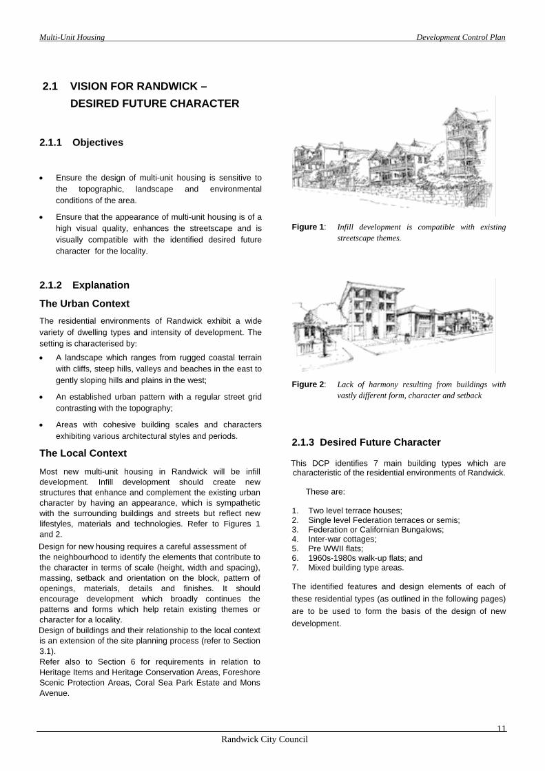
Most new multi-unit housing in Randwick will be infill development. Infill development should create new structures that enhance and complement the existing urban character by having an appearance, which is sympathetic with the surrounding buildings and streets but reflect new lifestyles, materials and technologies. Refer to Figures 1 and 2.
Design for new housing requires a careful assessment of the neighbourhood to identify the elements that contribute to
the character in terms of scale (height, width and spacing), massing, setback and orientation on the block, pattern of openings, materials, details and finishes. It should encourage development which broadly continues the patterns and forms which help retain existing themes or character for a locality.
Design of buildings and their relationship to the local context is an extension of the site planning process (refer to Section 3.1). Refer also to Section 6 for requirements in relation to Heritage Items and Heritage Conservation Areas, Foreshore Scenic Protection Areas, Coral Sea Park Estate and Mons Avenue.
Figure 1: Infill development is compatible with existing
streetscape themes.
Figure 2: Lack of harmony resulting from buildings with
vastly different form, character and setback
2.1.3 Desired Future Character
This DCP identifies 7 main building types which are characteristic of the residential environments of Randwick.
These are: 1. Two level terrace houses; 2. Single level Federation terraces or semis; 3. Federation or Californian Bungalows; 4. Inter-war cottages; 5. Pre WWII flats; 6. 1960s-1980s walk-up flats; and 7. Mixed building type areas. The identified features and design elements of each of these residential types (as outlined in the following pages) are to be used to form the basis of the design of new development.
Multi-Unit Housing Development Control Plan
Randwick City Council
12
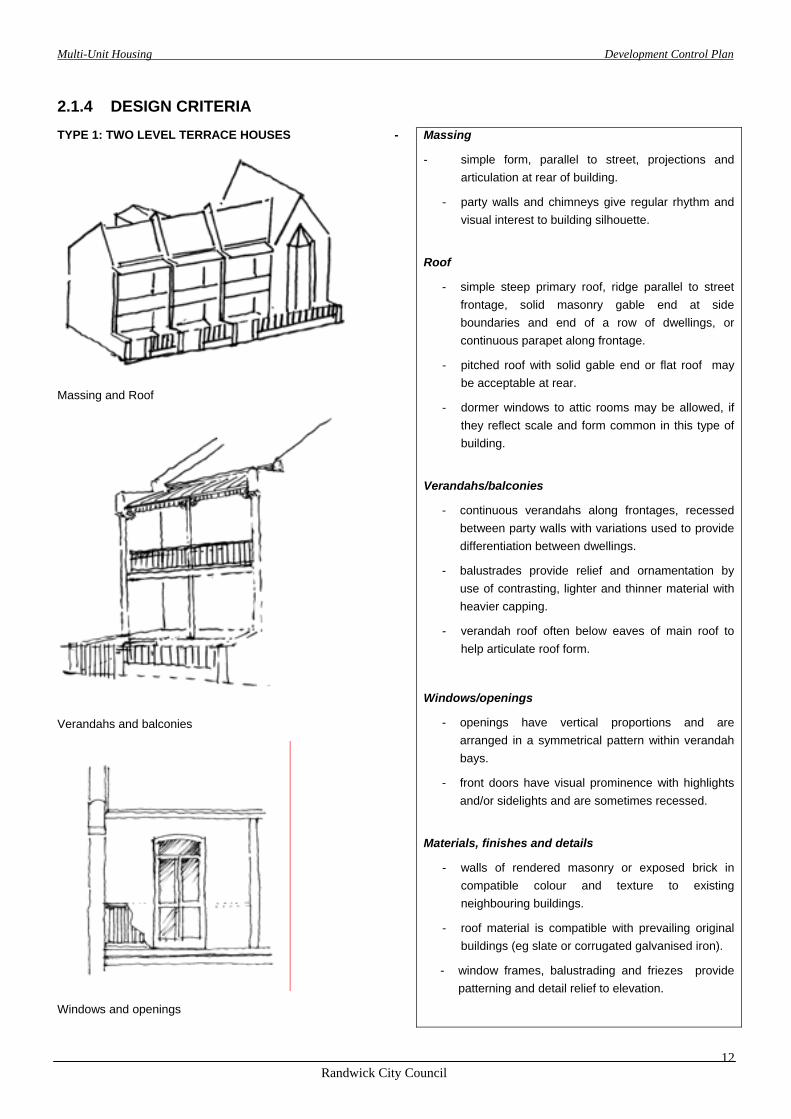
2.1.4 DESIGN CRITERIA TYPE 1: TWO LEVEL TERRACE HOUSES
Massing and Roof
Verandahs and balconies
Windows and openings
- Massing
- simple form, parallel to street, projections and articulation at rear of building.
- party walls and chimneys give regular rhythm and visual interest to building silhouette.
Roof
- simple steep primary roof, ridge parallel to street frontage, solid masonry gable end at side boundaries and end of a row of dwellings, or continuous parapet along frontage.
- pitched roof with solid gable end or flat roof may be acceptable at rear.
- dormer windows to attic rooms may be allowed, if they reflect scale and form common in this type of building.
Verandahs/balconies
- continuous verandahs along frontages, recessed between party walls with variations used to provide differentiation between dwellings.
- balustrades provide relief and ornamentation by use of contrasting, lighter and thinner material with heavier capping.
- verandah roof often below eaves of main roof to help articulate roof form.
Windows/openings
- openings have vertical proportions and are arranged in a symmetrical pattern within verandah bays.
- front doors have visual prominence with highlights and/or sidelights and are sometimes recessed.
Materials, finishes and details
- walls of rendered masonry or exposed brick in compatible colour and texture to existing neighbouring buildings.
- roof material is compatible with prevailing original buildings (eg slate or corrugated galvanised iron).
- window frames, balustrading and friezes provide patterning and detail relief to elevation.
Multi-Unit Housing Development Control Plan
Randwick City Council
13
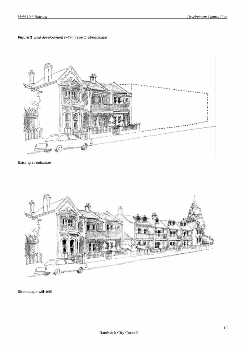
Figure 3 Infill development within Type 1 streetscape
Existing streetscape
Streetscape with infill
Multi-Unit Housing Development Control Plan
Randwick City Council
14
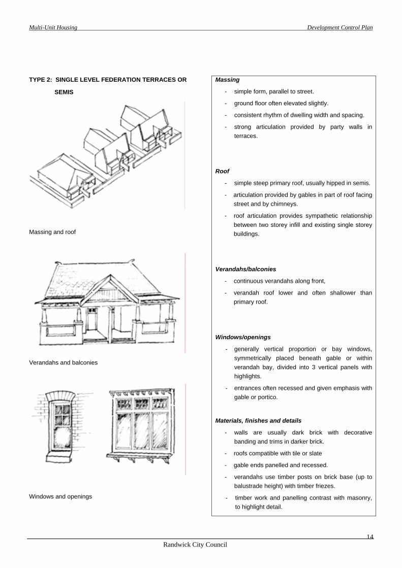
TYPE 2: SINGLE LEVEL FEDERATION TERRACES OR
SEMIS
Massing and roof
Verandahs and balconies
Windows and openings
Massing
- simple form, parallel to street.
- ground floor often elevated slightly.
- consistent rhythm of dwelling width and spacing.
- strong articulation provided by party walls in terraces.
Roof
- simple steep primary roof, usually hipped in semis.
- articulation provided by gables in part of roof facing street and by chimneys.
- roof articulation provides sympathetic relationship between two storey infill and existing single storey buildings.
Verandahs/balconies
- continuous verandahs along front,
- verandah roof lower and often shallower than primary roof.
Windows/openings
- generally vertical proportion or bay windows, symmetrically placed beneath gable or within verandah bay, divided into 3 vertical panels with highlights.
- entrances often recessed and given emphasis with gable or portico.
Materials, finishes and details
- walls are usually dark brick with decorative banding and trims in darker brick.
- roofs compatible with tile or slate
- gable ends panelled and recessed.
- verandahs use timber posts on brick base (up to balustrade height) with timber friezes.
- timber work and panelling contrast with masonry, to highlight detail.

Multi-Unit Housing Development Control Plan
Randwick City Council
15
Figure 4: Infill development within Type 2 streetscape
Existing streetscape
Streetscape with infill
Multi-Unit Housing Development Control Plan
Randwick City Council
16
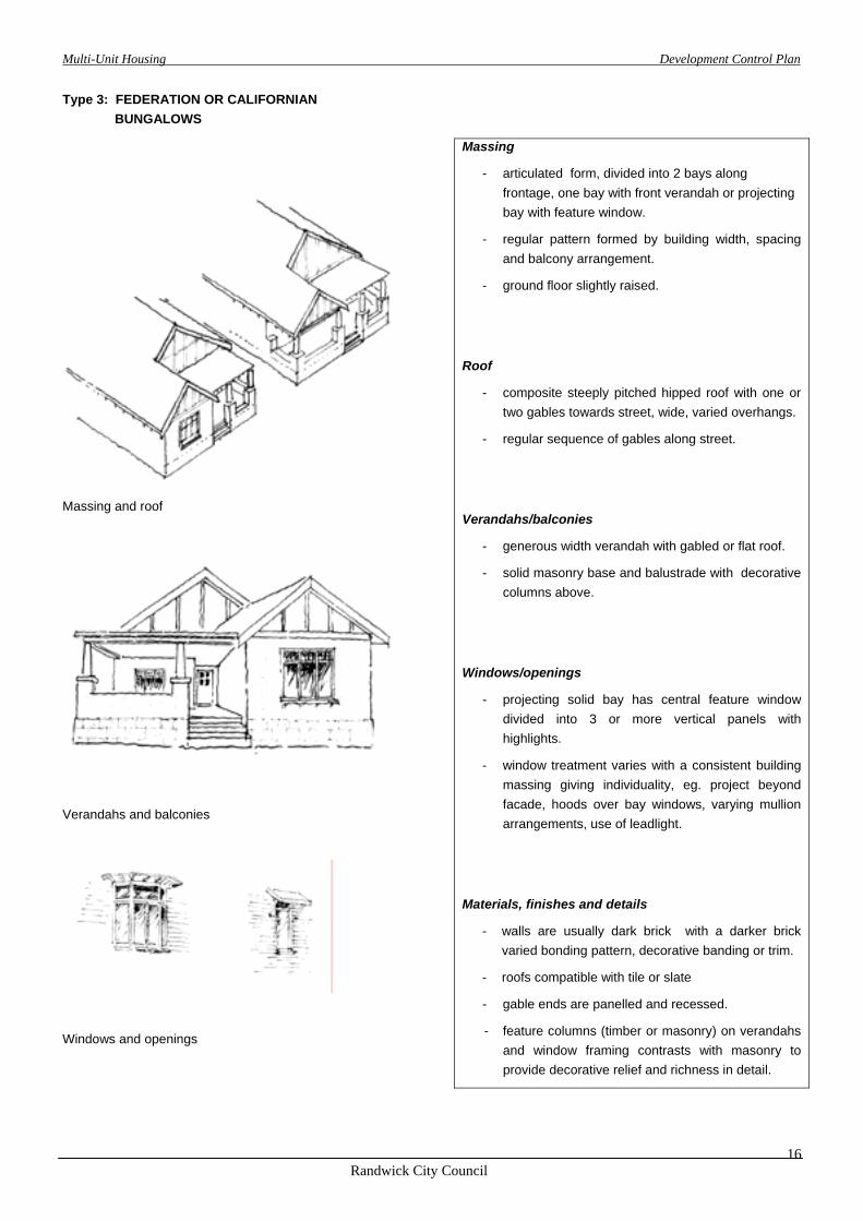
Type 3: FEDERATION OR CALIFORNIAN
BUNGALOWS
Massing and roof
Verandahs and balconies
Windows and openings
Massing
- articulated form, divided into 2 bays along frontage, one bay with front verandah or projecting bay with feature window.
- regular pattern formed by building width, spacing and balcony arrangement.
- ground floor slightly raised.
Roof
- composite steeply pitched hipped roof with one or two gables towards street, wide, varied overhangs.
- regular sequence of gables along street.
Verandahs/balconies
- generous width verandah with gabled or flat roof.
- solid masonry base and balustrade with decorative columns above.
Windows/openings
- projecting solid bay has central feature window divided into 3 or more vertical panels with highlights.
- window treatment varies with a consistent building massing giving individuality, eg. project beyond facade, hoods over bay windows, varying mullion arrangements, use of leadlight.
Materials, finishes and details
- walls are usually dark brick with a darker brick varied bonding pattern, decorative banding or trim.
- roofs compatible with tile or slate
- gable ends are panelled and recessed.
- feature columns (timber or masonry) on verandahs and window framing contrasts with masonry to provide decorative relief and richness in detail.
Multi-Unit Housing Development Control Plan
Randwick City Council
17
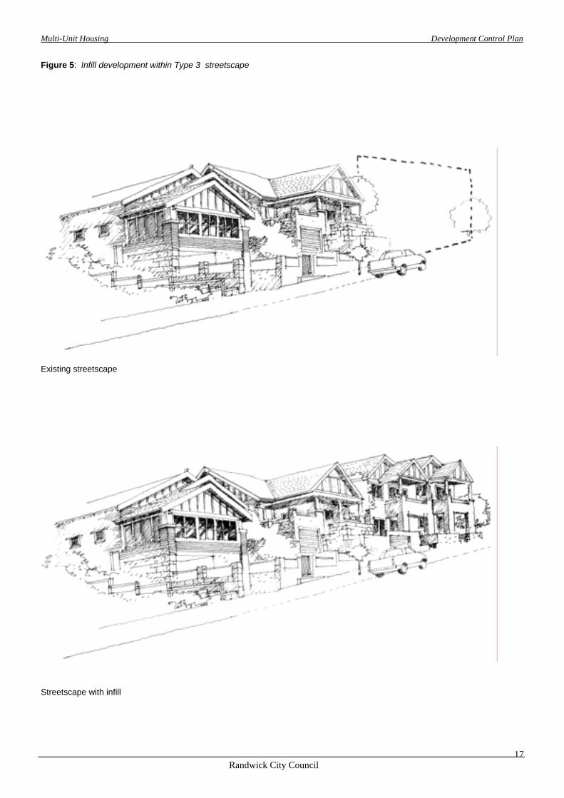
Figure 5: Infill development within Type 3 streetscape
Existing streetscape
Streetscape with infill
Multi-Unit Housing Development Control Plan
Randwick City Council
18
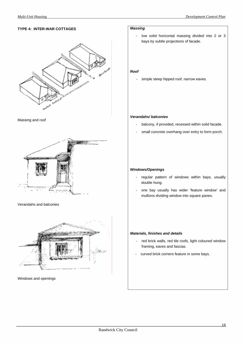
TYPE 4: INTER-WAR COTTAGES
Massing and roof
Verandahs and balconies
Windows and openings
Massing
- low solid horizontal massing divided into 2 or 3 bays by subtle projections of facade.
Roof
- simple steep hipped roof, narrow eaves.
Verandahs/ balconies
- balcony, if provided, recessed within solid facade.
- small concrete overhang over entry to form porch.
Windows/Openings
- regular pattern of windows within bays, usually double hung.
- one bay usually has wider ‘feature window’ and mullions dividing window into square panes.
Materials, finishes and details
- red brick walls, red tile roofs, light coloured window framing, eaves and fascias.
- curved brick corners feature in some bays.
Multi-Unit Housing Development Control Plan
Randwick City Council
19
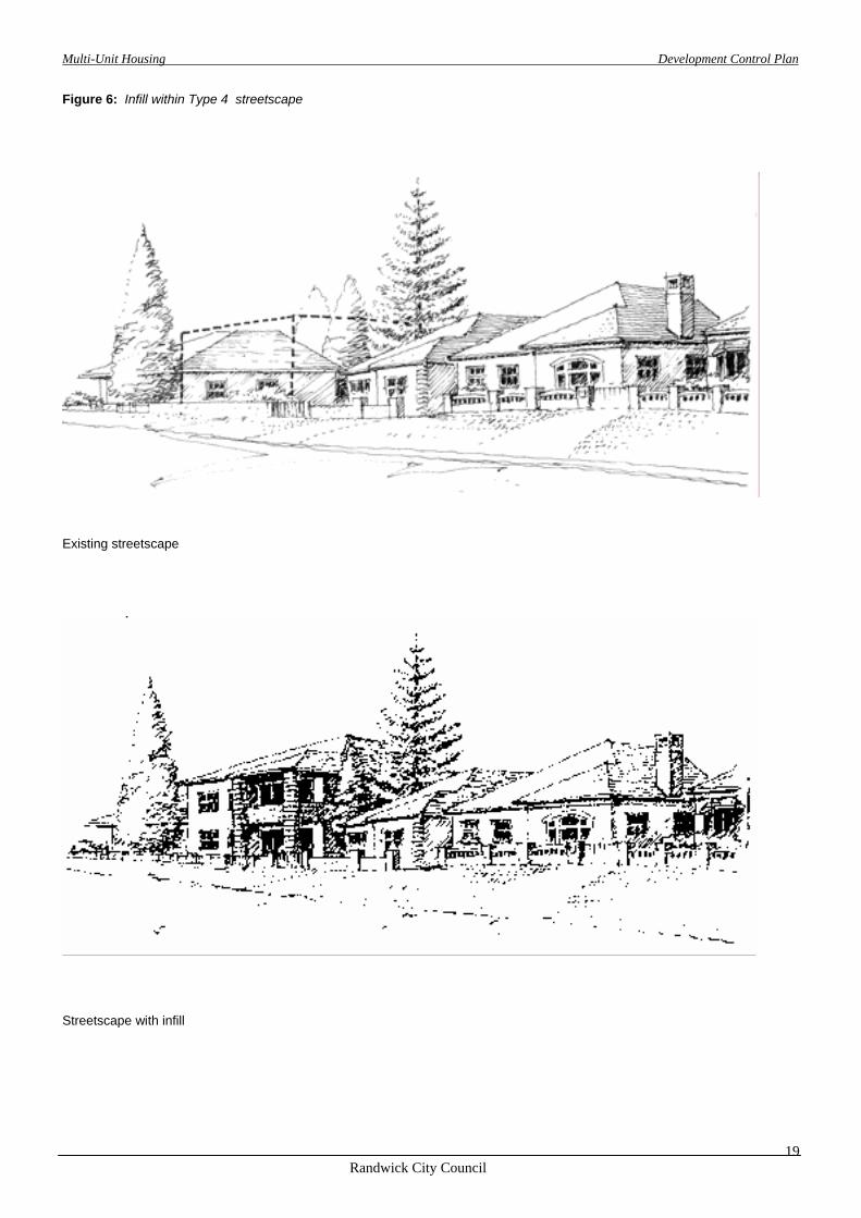
Figure 6: Infill within Type 4 streetscape
Existing streetscape
Streetscape with infill

Multi-Unit Housing Development Control Plan
Randwick City Council
20
TYPE 5: PRE WWII FLATS.
Massing and roof
Verandahs and balconies
Windows and openings
Massing
- 2 - 3 storey solid, masonry building divided into 3 bays along street frontage by slight projections of facade and/or attached piers.
- regular pattern of buildings, bays and spacing.
Roof
- simple, steep hipped roof, occasionally central feature gable or gable over end bays facing street.
- flat trafficable roof with solid parapet.
Verandahs/ balconies
- wholly or partially recessed within solid volume or building.
- entries usually face street with small portico or roof cantilever.
Windows/openings
- usually symmetrically placed within bays.
- differentiation between central bay (often stairs) and two side bays, and between floors.
- vertical proportions or wide openings divided into vertical proportioned window panels.
Materials, finishes and details
- walls of dark red brick or pastel shades with geometric brick bonding providing art deco trims at parapet or around central entry bay.
- rendered masonry.
- red tile roofs.
- contrast (white) columned window frames, roof eaves and fascias provide highlight.

Multi-Unit Housing Development Control Plan
Randwick City Council
21
Figure 7: Infill within Type 5 streetscape
Existing streetscape
Streetscape with infill
Multi-Unit Housing Development Control Plan
Randwick City Council
22
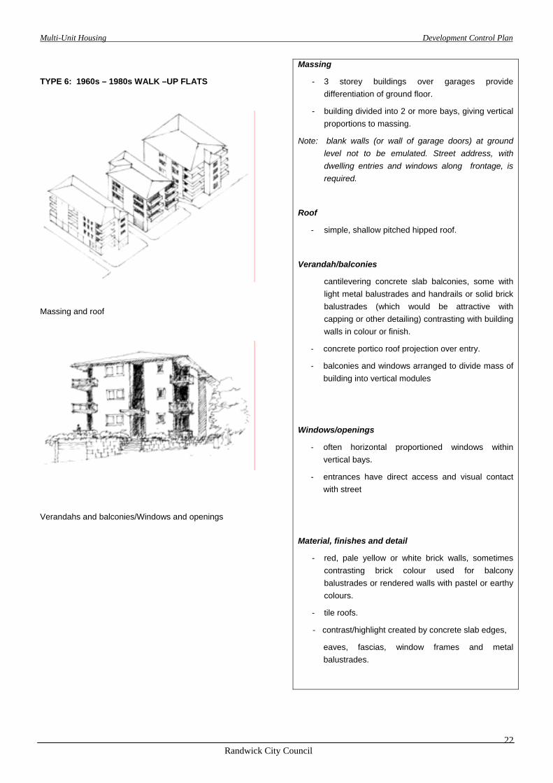
TYPE 6: 1960s – 1980s WALK –UP FLATS
Massing and roof
Verandahs and balconies/Windows and openings
Massing
- 3 storey buildings over garages provide differentiation of ground floor.
- building divided into 2 or more bays, giving vertical proportions to massing.
Note: blank walls (or wall of garage doors) at ground level not to be emulated. Street address, with dwelling entries and windows along frontage, is required.
Roof
- simple, shallow pitched hipped roof.
Verandah/balconies
cantilevering concrete slab balconies, some with light metal balustrades and handrails or solid brick balustrades (which would be attractive with capping or other detailing) contrasting with building walls in colour or finish.
- concrete portico roof projection over entry.
- balconies and windows arranged to divide mass of building into vertical modules
Windows/openings
- often horizontal proportioned windows within vertical bays.
- entrances have direct access and visual contact with street
Material, finishes and detail
- red, pale yellow or white brick walls, sometimes contrasting brick colour used for balcony balustrades or rendered walls with pastel or earthy colours.
- tile roofs.
- contrast/highlight created by concrete slab edges,
eaves, fascias, window frames and metal balustrades.
Multi-Unit Housing Development Control Plan
Randwick City Council
23
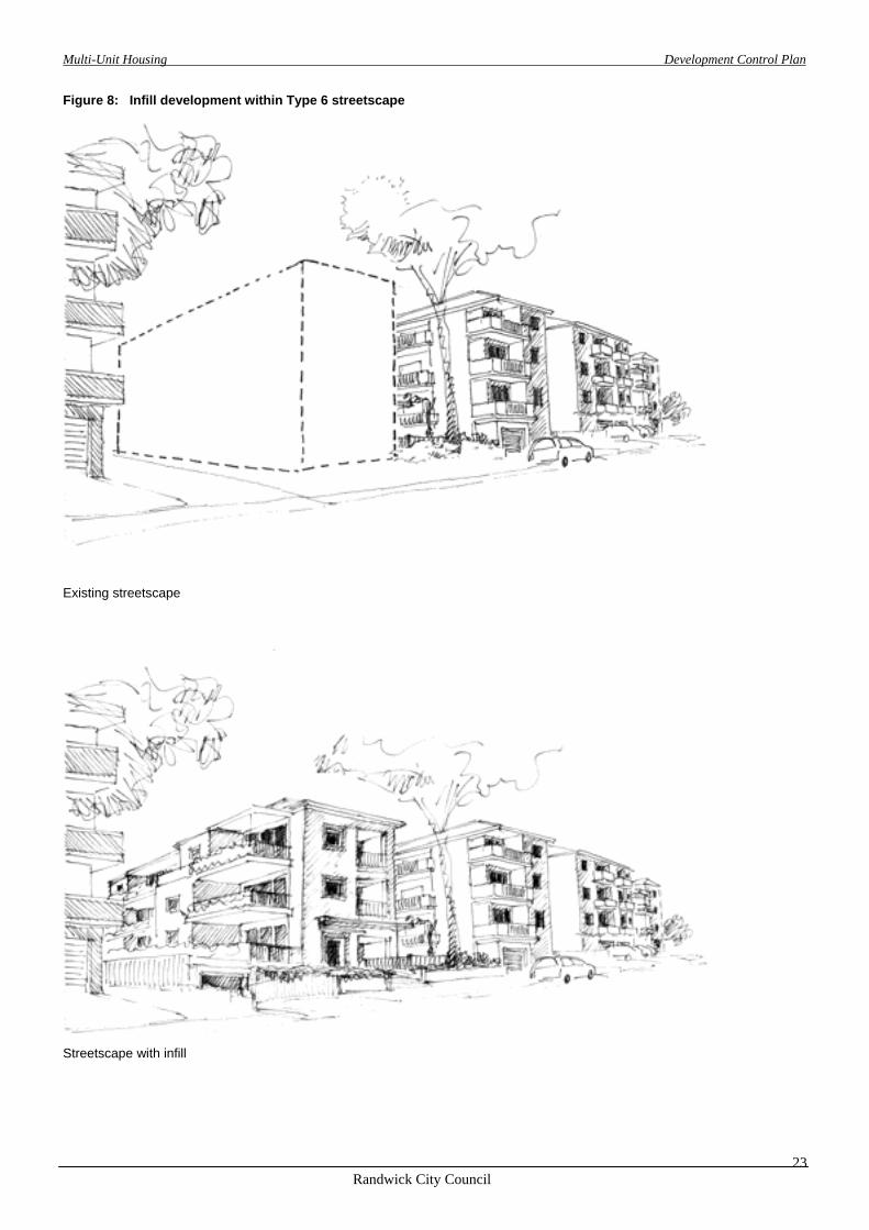
Figure 8: Infill development within Type 6 streetscape
Existing streetscape
Streetscape with infill

Multi-Unit Housing Development Control Plan
Randwick City Council
24
TYPE 7: MIXED BUILDING TYPE AREAS.
Where the adjacent streetscape is characterised by a variety of building types, the design of the new development can relate to one or other of the prevalent neighbouring building types.
Figure 9: Alternative options where the streetscape is characterised by two or more distinctive building types

Multi-Unit Housing Development Control Plan
Randwick City Council
25
Part 3BUILDING DESIGN

Multi-Unit Housing Development Control Plan
Randwick City Council
26
3.1 SITE PLANNING
3.1.3 LEP Controls Clause 2(d), (e), (g), (h) and (j) Aims of the LEP. Clauses 11 and 12 Objectives for the 2B and 2C zones.
3.1.1 Objectives • Ensure that local site conditions, positive attributes
of the site, constraints and opportunities are taken into account in the design of development.
• Ensure that new development responds to the
topography of the site and its surrounds. • Ensure that the relationship of new development to
adjoining development is considered in the design process and negative impacts are minimised.
• Ensure that the design of new development meets
the lifetime needs of the community, including families, the elderly and people with a disability.
3.1.2 Explanation Site analysis and planning is an essential component in the design of development proposals. It takes into account existing environmental conditions such as trees, vegetation, topography, existing water courses, drainage lines, view lines and microclimate. Proper site planning ensures that the positive attributes of an area will be enhanced in the design of a development proposal.
Figure 10: Example of site analysis

Multi-Unit Housing Development Control Plan
Randwick City Council
27
3.1.4 DCP Controls
Performance Requirements
Preferred Solutions
P1 All development applications must be accompanied by a Site Analysis Plan which identifies development opportunities and constraints for the site. The plan is to demonstrate that these factors have been instrumental in shaping the design of the proposed development. It is also to show how the Desired Future Character identified in Part 2 has been interpreted in the design process and how the proposed development
incorporates:
Site topography and land slope. Site features and orientation. Principles of ecologically sustainable
development. Vegetation and landscape setting. Form and style of existing buildings on the site
and in the local area. View corridors. Significant streetscape features such as stone
retaining walls. Local street and pedestrian networks. Access requirements including people with a
disability or other special needs. Solar access and access to ventilating breezes. Microclimate. Drainage. Services. Access
P2 Development sites have appropriate areas and dimensions to allow for the satisfactory siting of buildings and ensure adequate separation between buildings.
Building design is related to the size, shape and dimensions of the site. P3 Development on corner sites provides a positive response to the prominent position and addresses both street frontages.
S2 Sites are of a regular shape and have a frontage of at least 20 metres.
Note: Narrow or irregular shaped blocks may not be suitable for redevelopment. Development on these sites may need to be scaled down to reduce the potential for adverse impacts on adjoining properties.

Multi-Unit Housing Development Control Plan
Randwick City Council
28
3.2 HEIGHT
3.2.3 LEP Controls
3.2.1 Objectives
• Use maximum height limits to assist in responding to
the desired future character of the local context.
• Minimise the impact of development on adjoining and nearby land.
• Control the bulk and scale of development.
3.2.2 Explanation
Building height is a very important control in relation to the bulk and scale of development. It is a major factor in determining the character of a locality as well as the scale and amount of development that occurs in that locality.
Building height is also a major factor in relation to the degree of overshadowing and potential loss of privacy and views. This is particularly apparent where new development directly adjoins the rear yard of adjacent dwellings.
Clause 33
(1) The maximum height for development in Zone No. 2B is 9.5 metres.
(2) The maximum height for development in Zone No. 2C is 12 metres.
(3) The maximum height for any external wall of a building in Zone No. 2B is 7 metres.
(4) The maximum height for any external wall of a building in Zone No. 2C is 10 metres.
Building heights are measured vertically from any point on ground level.
Clause 49
Ground level is defined as the level of a site that existed at the appointed day (which is the day the LEP was gazetted – 26 June 1998).
Note:
• Maximum permissible heights in the LEP are not ‘as of right’ controls.
• The achievement of maximum heights depends on how the proposed development meets the objectives and design criteria of all sections of this DCP.
• Variations to the maximum external wall height (such as gable ends) may be considered if they lead to an improved design
3.2.4 DCP Controls
Performance requirements
Preferred solutions
P1 Heights of walls, their location and orientation do not cause substantiated adverse impacts on the streetscape or adjoining properties, particularly in relation to privacy, solar access and building bulk.
P2 Variations in massing and height create visual interest, distribute the bulk of the building and minimise amenity impacts on adjoining properties and the streetscape.

Multi-Unit Housing Development Control Plan
Randwick City Council
29
3.3 BUILDING SETBACKS
3.3.1 Objectives 3.3.2 Explanation • Reduce the impact of development on adjoining
land.
• Ensure adequate separation between buildings for landscaping, visual and acoustic privacy, sunlight penetration and private open space.
• Integrate development with desirable characteristics of the established streetscape.
Building setbacks define the overall footprint of a building and the outer extremities of that building in relation to front, side and rear boundaries. They have a significant influence on the character of a street and determine its prevailing form.
Variations in front setbacks can be used to accentuate or diminish the prominence of streetscape elements. The separation between buildings and public spaces is an important principle of design for infill development. Setbacks also influence the potential for overshadowing and privacy problems to adjoining and nearby development.
3.3.3 LEP Controls Clause 2 (g)
Aims of the LEP
3.3.4 DCP Controls
Performance Requirements Preferred Solutions
Front boundary setbacks
P1 The front setback is determined by the existing and desired character of the streetscape.
The setback is to be consistent with the setback of adjoining development or the dominant setback along the street.
Side boundary setbacks
P2 Buildings are set back from the side boundary to ensure that:
- there is adequate separation between buildings to maintain reasonable levels of solar access and minimise overshadowing.
- reasonable levels of privacy between neighbouring dwellings and their open spaces are provided.
- opportunities for landscaping and private open space are provided.
- streetscape amenity is maintained.
S2 Zone 2B
Buildings (including balconies) maintain a minimum average setback (measured for the length of the building along that boundary) of 4 metres from any side boundary
No part of the building is closer than 2.5 metres from any side boundary.
The maximum length of any one section of wall (without any articulation) is 10 metres. The minimum length of any step is 3 metres.
Zone 2C
Buildings (including balconies) maintain a minimum average setback (measured for the length of the building along that boundary) of 5 metres from any side boundary
No part of the building is closer than 3.5 metres from any side boundary.
The maximum length of any one section of wall (without any articulation) is 10 metres. The minimum length of any step is 3 metres.
Multi-Unit Housing Development Control Plan
Randwick City Council
30
Performance Requirements Preferred Solutions
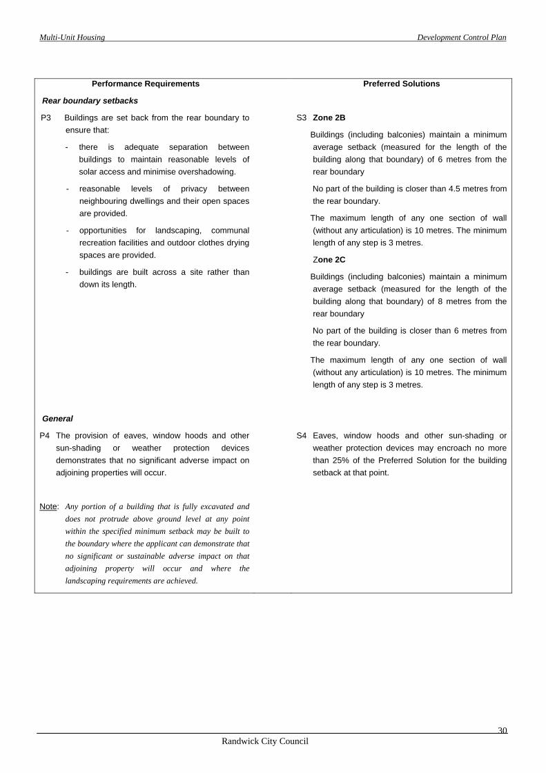
Rear boundary setbacks
P3 Buildings are set back from the rear boundary to ensure that:
- there is adequate separation between buildings to maintain reasonable levels of solar access and minimise overshadowing.
- reasonable levels of privacy between neighbouring dwellings and their open spaces are provided.
- opportunities for landscaping, communal recreation facilities and outdoor clothes drying spaces are provided.
- buildings are built across a site rather than down its length.
S3 Zone 2B
Buildings (including balconies) maintain a minimum average setback (measured for the length of the building along that boundary) of 6 metres from the rear boundary
No part of the building is closer than 4.5 metres from the rear boundary.
The maximum length of any one section of wall (without any articulation) is 10 metres. The minimum length of any step is 3 metres.
Zone 2C
Buildings (including balconies) maintain a minimum average setback (measured for the length of the building along that boundary) of 8 metres from the rear boundary
No part of the building is closer than 6 metres from the rear boundary.
The maximum length of any one section of wall (without any articulation) is 10 metres. The minimum length of any step is 3 metres.
General
P4 The provision of eaves, window hoods and other sun-shading or weather protection devices demonstrates that no significant adverse impact on adjoining properties will occur.
S4 Eaves, window hoods and other sun-shading or weather protection devices may encroach no more than 25% of the Preferred Solution for the building setback at that point.
Note: Any portion of a building that is fully excavated and does not protrude above ground level at any point within the specified minimum setback may be built to the boundary where the applicant can demonstrate that no significant or sustainable adverse impact on that adjoining property will occur and where the landscaping requirements are achieved.

Multi-Unit Housing Development Control Plan
Randwick City Council
31
3.4 DENSITY
3.4.1 Objectives
• Control the size, bulk and scale of development to reflect the desired future character of the area.
3.4.3 LEP Controls
3.4.2 Explanation Density of development is a significant indicator of the potential size of a likely development proposal. This in turn can indicate the extent of possible adverse impacts of a proposed development on adjoining land. Density is a very important development control. It is often used to determine the development potential and hence the relative value of a site.
Clause 32
The maximum floor space ratio for development in Zone 2B is 0.65:1.
The maximum floor space ratio for development in Zone 2C is 0.9:1. This reduces to 0.65:1 where the site area is less than 700 square metres.
The area of any access handle of a battleaxe lot is not included as part of the site area for the purposes of calculating the floor space ratio.
Note:
• Maximum permissible floor space ratios in the LEP are not “as of right” controls. The achievement of maximum floor space ratios depends on how the proposed development meets the objectives and performance requirements of all sections of this DCP.
• Enclosed balconies are included in calculations of floor space for the purpose of determining floor space ratios.
Clause 49 Definitions:
“floor space ratio” means the ratio of the total gross floor area of all buildings (existing and/or proposed) to the site area;
“gross floor area” means the sum of the areas of each level of a building where the area of each level is taken to be the area within the inner face of the external enclosing walls and the area of an any attic measured at 2.1m above the floor level of the attic excluding :
(a) columns, fin walls, shading devices, awnings, balconies and any other elements, projections or works outside the general lines of the outer face of the external wall, and
(b) lift towers, cooling towers, machinery and plant rooms, and air-conditioning ducts, and
(c) associated car parking and any internal vehicular or pedestrian access to that parking (to ground level), and
(d) space for the loading and unloading of goods.
“site area”, in relation to development, means the area of land to which an application for consent to carry out development relates, but does not include any part of that land on which the development is not permitted by or under this plan or any other environmental planning instrument.
3.4.4 DCP Controls
Performance Requirements Preferred Solutions
P1 Building bulk is compatible with surrounding built forms and minimises impact of building bulk on nearby buildings, open spaces and the streetscape.
Multi-Unit Housing Development Control Plan
Randwick City Council
32
3.5 FENCES
3.5.1 Objectives
• Reduce the impact of front fences on the streetscape.
• Integrate front fencing with the desired future
character of the streetscape.
• Complement fence design with landscape features and dwelling design.
3.5.2 Explanation Proper consideration of the design, location and treatment of front fences can make a valuable contribution to the amenity and environmental quality of a development and the local area.
While privacy and security of individual households is an important consideration, solid fences along the street often have a negative impact on both the streetscape and personal safety and security by reducing opportunities for overlooking public areas.
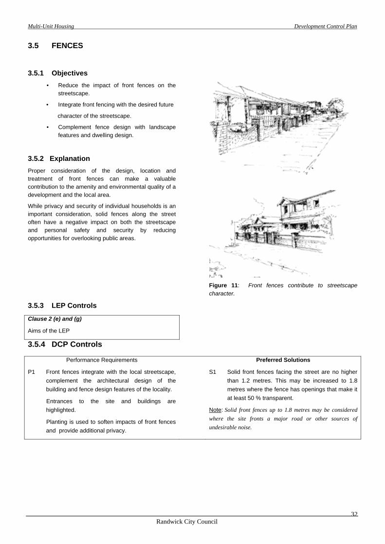
Figure 11: Front fences contribute to streetscape character.
3.5.3 LEP Controls
Clause 2 (e) and (g)
Aims of the LEP
3.5.4 DCP Controls
Performance Requirements Preferred Solutions
P1 Front fences integrate with the local streetscape, complement the architectural design of the building and fence design features of the locality.
Entrances to the site and buildings are highlighted.
Planting is used to soften impacts of front fences and provide additional privacy.
S1 Solid front fences facing the street are no higher than 1.2 metres. This may be increased to 1.8 metres where the fence has openings that make it at least 50 % transparent.
Note: Solid front fences up to 1.8 metres may be considered where the site fronts a major road or other sources of undesirable noise.
Multi-Unit Housing Development Control Plan
Randwick City Council
33
PART 4
ENVIRONMENTAL CONTROLS
Multi-Unit Housing Development Control Plan
Randwick City Council
34
4.1 LANDSCAPING AND PRIVATE OPEN SPACE
4.1.1 Objectives
4.1.3 LEP Controls • Enhance and contribute to the desired future
character of the streetscape and the locality.
• Reduce areas of hard paving.
• Relate to buildings and make a positive contribution to the lifestyle of the occupants.
• Minimise stormwater run-off and water consumption through selection and management of landscaping features.
• Provide useful areas of private open space for outdoor living and recreation to serve the needs of the residents and enhance their quality of life.
• Set minimum standards for the size, shape and location of private open space.
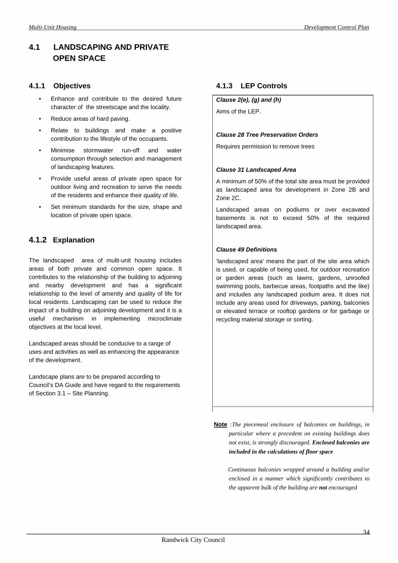
4.1.2 Explanation The landscaped area of multi-unit housing includes areas of both private and common open space. It contributes to the relationship of the building to adjoining and nearby development and has a significant relationship to the level of amenity and quality of life for local residents. Landscaping can be used to reduce the impact of a building on adjoining development and it is a useful mechanism in implementing microclimate objectives at the local level. Landscaped areas should be conducive to a range of uses and activities as well as enhancing the appearance of the development. Landscape plans are to be prepared according to Council’s DA Guide and have regard to the requirements of Section 3.1 – Site Planning.
Clause 2(e), (g) and (h)
Aims of the LEP.
Clause 28 Tree Preservation Orders
Requires permission to remove trees
Clause 31 Landscaped Area
A minimum of 50% of the total site area must be provided as landscaped area for development in Zone 2B and Zone 2C.
Landscaped areas on podiums or over excavated basements is not to exceed 50% of the required landscaped area.
Clause 49 Definitions
‘landscaped area’ means the part of the site area which is used, or capable of being used, for outdoor recreation or garden areas (such as lawns, gardens, unroofed swimming pools, barbecue areas, footpaths and the like) and includes any landscaped podium area. It does not include any areas used for driveways, parking, balconies or elevated terrace or rooftop gardens or for garbage or recycling material storage or sorting.
Note :The piecemeal enclosure of balconies on buildings, in
particular where a precedent on existing buildings does not exist, is strongly discouraged. Enclosed balconies are included in the calculations of floor space
Continuous balconies wrapped around a building and/or enclosed in a manner which significantly contributes to the apparent bulk of the building are not encouraged
Multi-Unit Housing Development Control Plan
Randwick City Council
35
4.1.4 DCP Controls
Performance Requirements Preferred Solutions
Landscaped Area
P1 Landscaped areas are of sufficient size to enable the space to be used for recreational activities, or be capable of growing substantial vegetation.
S1 The minimum dimension for an area of land included in calculations for the landscaped area requirements is 2 metres.
P2 Landscaped areas around flat buildings are treated as communal open space for use by all residents of development. Common open space is not divided up and allocated to individual dwellings within a development to the exclusion of other users on upper levels.
Private open space
General P3 Private open space : - Provides privacy for its users; - is readily accessible from the main living areas of
the dwelling so that it can become an extension of the dwelling;
- provides opportunities for outdoor recreation and living. P4 Private open space may only be provided
between the front of the building and the street where building setback and front fence design achieve a sympathetic relationship with the street.
Townhouses, row housing, villa housing etc
P5 Each dwelling is provided with an area of useable private open space or courtyard area, at ground or podium level.
S5 Townhouses, row houses, villa houses etc have a minimum area of 25 m2 of private open space.
Each area of private open space at ground or podium level is capable of containing a rectangle with minimum dimensions of 3m x 4m with only minor changes of level.
Flats and apartments
P6 Each dwelling has access to an area of private open space in the form of a courtyard, balcony, deck or roof garden, accessible from within the dwelling.
S6 Private open space for flats and apartments has a
minimum area of 8 m2 and a minimum dimension of 2 metres.

Multi-Unit Housing Development Control Plan
Randwick City Council
36
4.2 PRIVACY
4.2.1 Objectives
• Ensure new development is designed so that its occupants enjoy visual and acoustic privacy.
• Respect the existing level of privacy of adjoining and nearby properties.
4.2.2 Explanation
Privacy is an important quality of life consideration in relation to housing and choice of housing.
Privacy plays a significant role in the perceived level of enjoyment of living in a variety of urban environments. The design of a development will have a major influence on the privacy levels for both the occupants of a development and the occupants of adjoining and nearby properties. A development that has been designed with a high emphasis on quality of life considerations such as privacy (for all affected parties) will impact less on its neighbours and blend better with the local environment.
4.2.3 LEP Controls
Clause 2 (g), (j) and (k)
Aims of the LEP.
Clauses 11 and 12
Objectives for the 2B and 2C zones.
Figure 12 Some techniques to protect privacy
Locating windows to limit overlooking
Offset windows Screening
Splay windows Build to boundary
Some techniques for providing privacy to a lower dwellings private open space
Planter box Vertical or horizontallouvre screens
Pergola Level change
Multi-Unit Housing Development Control Plan
Randwick City Council
37
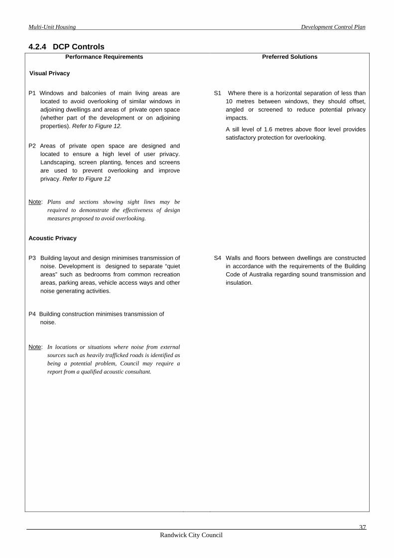
4.2.4 DCP Controls
Performance Requirements
Preferred Solutions
Visual Privacy
P1 Windows and balconies of main living areas are located to avoid overlooking of similar windows in adjoining dwellings and areas of private open space (whether part of the development or on adjoining properties). Refer to Figure 12.
S1 Where there is a horizontal separation of less than 10 metres between windows, they should offset, angled or screened to reduce potential privacy impacts.
A sill level of 1.6 metres above floor level provides satisfactory protection for overlooking.
P2 Areas of private open space are designed and located to ensure a high level of user privacy. Landscaping, screen planting, fences and screens are used to prevent overlooking and improve privacy. Refer to Figure 12
Note: Plans and sections showing sight lines may be required to demonstrate the effectiveness of design measures proposed to avoid overlooking.
Acoustic Privacy
P3 Building layout and design minimises transmission of noise. Development is designed to separate “quiet areas” such as bedrooms from common recreation areas, parking areas, vehicle access ways and other noise generating activities.
P4 Building construction minimises transmission of noise. Note: In locations or situations where noise from external
sources such as heavily trafficked roads is identified as being a potential problem, Council may require a report from a qualified acoustic consultant.
S4 Walls and floors between dwellings are constructed in accordance with the requirements of the Building Code of Australia regarding sound transmission and insulation.
Multi-Unit Housing Development Control Plan
Randwick City Council
38
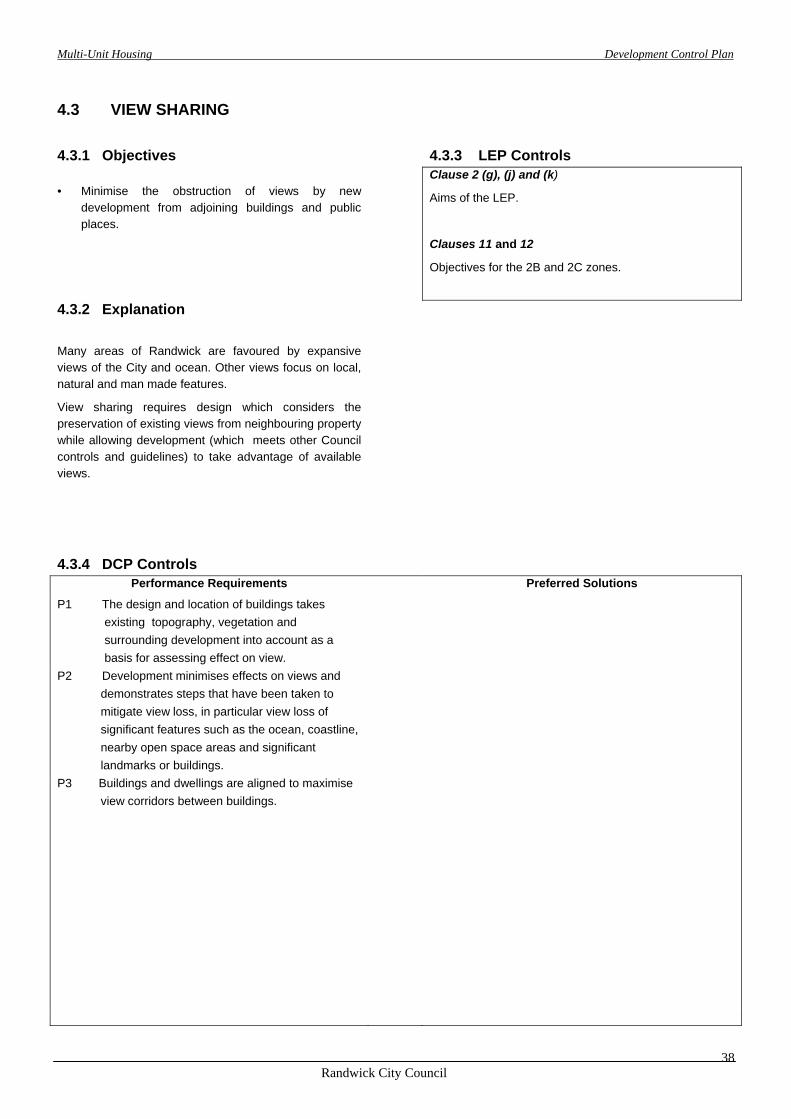
4.3 VIEW SHARING
4.3.1 Objectives 4.3.3 LEP Controls • Minimise the obstruction of views by new
development from adjoining buildings and public places.
Clause 2 (g), (j) and (k)
Aims of the LEP.
Clauses 11 and 12
Objectives for the 2B and 2C zones.
4.3.2 Explanation
Many areas of Randwick are favoured by expansive views of the City and ocean. Other views focus on local, natural and man made features.
View sharing requires design which considers the preservation of existing views from neighbouring property while allowing development (which meets other Council controls and guidelines) to take advantage of available views.
4.3.4 DCP Controls
Performance Requirements Preferred Solutions
P1 The design and location of buildings takes existing topography, vegetation and surrounding development into account as a basis for assessing effect on view.
P2 Development minimises effects on views and demonstrates steps that have been taken to mitigate view loss, in particular view loss of significant features such as the ocean, coastline, nearby open space areas and significant landmarks or buildings.
P3 Buildings and dwellings are aligned to maximise view corridors between buildings.
Multi-Unit Housing Development Control Plan
Randwick City Council
39
4.4 SOLAR ACCESS AND ENERGY EFFICIENCY
4.4.1 Objectives 4.4.2 Explanation
• Maximise the implementation of energy efficient practices to conserve non-renewable energy sources and minimise greenhouse gas emissions and air pollution.
• Maximise the opportunity to replace grid supplied electricity with renewable energy sources such as solar hot water and photovoltaic electricity generation.
• Allow reasonable solar access for the purposes of water heating and electricity generation for new development and for adjoining properties.
• Use siting, layout and construction of buildings to achieve year-round comfort and minimise the need for fuel based heating or cooling.
• Maximise the use of construction materials and processes that have the least adverse environmental effects.
The nature of the established topography, street and building pattern makes optimum solar orientation difficult to achieve for all dwellings within a multi unit housing development. Conversely, multi unit housing has the potential to be more energy efficient because common walls and stacking of dwelling units may result in less external wall and ceiling/roof area through which unwanted heat losses or gains occur.
The collective effect of design decisions can be evaluated by Nat HERS, a computer simulation tool used to rate the thermal performance of buildings. Five stars indicates the highest efficiency. Many energy saving measures cost little to achieve if adopted at the design stage, yet may be impossible to accomplish once fundamental decisions such as orientation and internal layout have been finalised
4.4.3 LEP Controls Clause 2 (d), (g), (h) and (j)
Aims of the LEP.
Clauses 11 and 12
Objectives for the 2B and 2C zones.
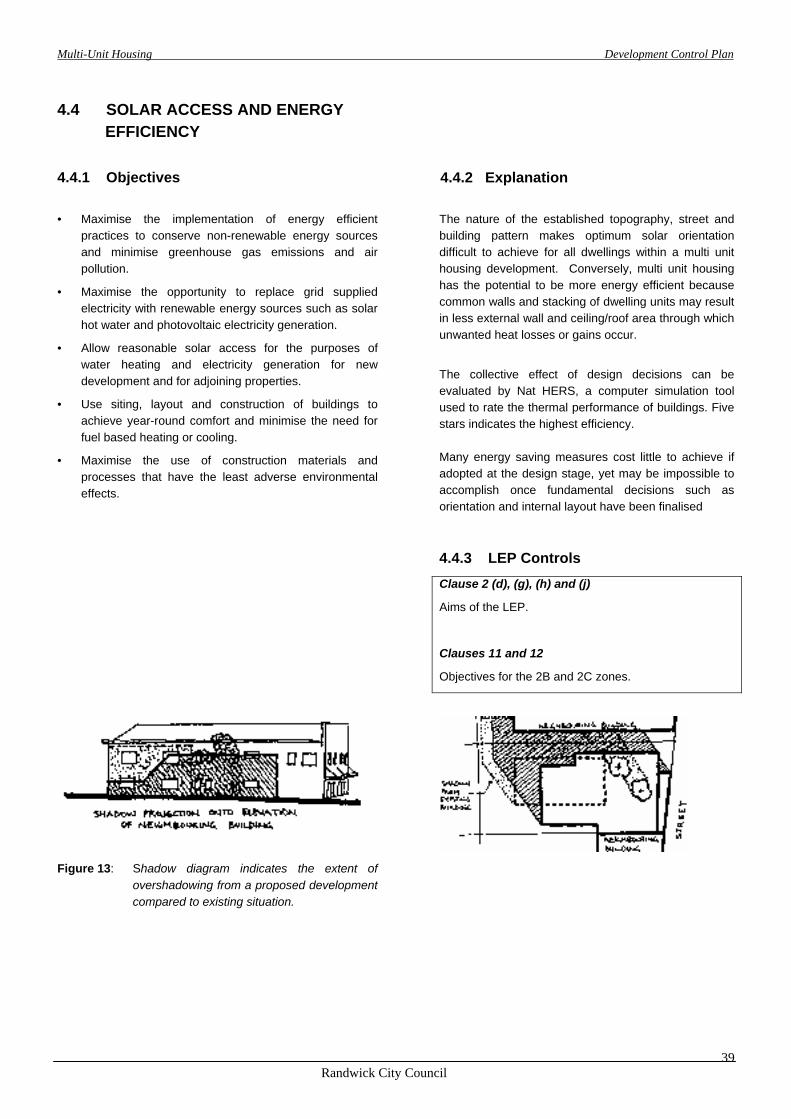
Figure 13: Shadow diagram indicates the extent of overshadowing from a proposed development compared to existing situation.
Multi-Unit Housing Development Control Plan
Randwick City Council
40
4.4.4 DCP Controls
Performance Requirements Preferred Solutions
Solar Access to Neighbouring Properties
P1 The design, orientation and siting of new buildings and landscaping minimises loss of solar access to neighbouring properties.
P1.1 Solar access to existing solar collectors on adjacent buildings is maintained between 9am and 3pm each day, throughout the year.
P1.2 Living areas of neighbouring dwellings do not have access to sunlight reduced to less than 3 hours per day throughout the year*.
P1.3 At least 50% of the principal landscaped areas of neighbouring dwellings does not have access to sunlight reduced to less than 3 hours per day throughout the year. *
* If less than this is available in the existing situation, the new development is not to reduce this further.
Building Layout, Design and Construction
P4 Buildings and outdoor spaces are designed to protect from prevailing strong winds and adverse weather conditions.
• Living areas are orientated to the north with access to winter sun and summer shade.
• Larger windows are located on the north side where they are exposed to the lower winter sun, but can be shaded by roof eaves, verandahs or balconies from high summer sun. Windows are protected with effective shading devices such as verandahs, hoods and external screens.
S4 75% of dwellings in a development achieve 3.5 star rating by Nat HERS or equivalent and no dwelling achieves less than 3 stars, unless the site analysis can demonstrate that this is not achievable on a particular site and an Energy Performance Statement demonstrates that the design of the dwelling units satisfies the intent of these objectives and performance criteria.
The NatHERS rating for each dwelling (on a typical unit basis) is provided with the application.
Note: If central ducted heating/cooling system is proposed in the development, a minimum of 4.5 stars Nat HERS rating is achieved.
P5 Buildings have an area of roof with appropriate orientation and pitch, suitable for the installation of solar collectors.
S5 Adequate roof area should be provided facing between 45 degrees east and 45 degrees west of north, and a slope between 15 and 55 degrees to the horizontal is provided for the installation of solar collectors.
P6 Heat loss is minimised in plumbing and layout of services by location of services and insulation of hot water pipes.
P7 Adequate space is provided for outdoor clothes drying.
P8 No rainforest timbers or timbers cut from old growth forest are used. Construction materials and products with least environmental impact are selected, ie: - low embodied energy - least polluting, recyclable or re-useable - durable - low maintenance.

Multi-Unit Housing Development Control Plan
Randwick City Council
41
4.5 SAFETY AND SECURITY
4.5.1 Objectives 4.5.3 LEP Controls
• Create a residential environment in which everyone will feel secure and free of threat from assault or burglary.
• Discourage crime in residential areas.
Clause 2(j) Aims of the LEP. Clauses 11 and 12 Objectives for the 2B and 2C zones.
4.5.2 Explanation
There is a strong perception in the community that modern housing developments frequently create hazardous conditions in which the risk of physical assault and other criminal activity are increased. These controls aim to minimise such risks and create a residential environment in which all members of the population will feel secure.
4.5.4 DCP Controls
Performance Requirements Preferred Solutions
P1 Building and landscaping design allows casual surveillance of footpaths and driveways (which is important for the safety of residents and passing pedestrians, and for the security of the neighbourhood).
P2 Approaches to the site and the entries of each dwelling are visible from within that dwelling.
P3 High walls and parking structures around buildings and open space areas which obstruct views into the development are avoided.
P4 Resident car parking areas are equipped with security grilles or doors.
P5 Visitor parking spaces are clearly identifiable and located to facilitate surveillance by some units.
P6 Visitor entry to all units and internal common areas is controlled by intercom and remote locking systems.
P7 Adequate lighting for personal safety and security is provided in common and access areas of the development.
P8 External lighting is neither intrusive nor creates a
nuisance for nearby residents.
Multi-Unit Housing Development Control Plan
Randwick City Council
42
Part 5FACILITIES AND ACCESS
Multi-Unit Housing Development Control Plan
Randwick City Council
43
5.1 PARKING
5.1.1 Objectives 5.1.3 LEP Controls Clause 2 (g), (h), (j) and (k)
Aims of the LEP
• Provide adequate and convenient parking for both residents and visitors.
• Provide bicycle access and facilities.
• Ensure that on-site parking and driveway areas are not visually obtrusive and do not detract from the appearance of dwellings and the streetscape.
5.1.2 Explanation
It is important to ensure that sufficient on-site parking is provided for new residential development. Car parking provision needs to be balanced against a number of factors which may allow variations to the normal standards including:
- availability of public transport;
- availability of on street parking and demands generated by other activities in the area;
- location of local facilities such as shops, schools, recreational and community facilities;
- car requirements of people of differing socio- economic status, age and stages of family life cycle;
For more specific details refer to
Council’s Development Control Plan – Parking; and
Roads and Traffic Authority “Guide to Traffic Generating Development”.
Note:
Variations to the specified parking requirements will only be considered where supported by an independent report prepared by a suitably qualified consultant, addressing, in particular, the objectives of this DCP and demonstrating that adequate off-street parking to meet the needs of residents and visitors is provided, considering:
- the availability and access to public transport
- levels of car ownership
- - availability and demand for car parking in the vicinity
of the development.

Multi-Unit Housing Development Control Plan
Randwick City Council
44
5.1.4 DCP Controls
Performance Requirements Preferred Solutions
P1 Garages and parking structures are sited and designed to not dominate the street frontage by:
- minimising frontage width; - ensuring that the form, materials and detailing - complement the associated building; - being excavated, or setback further from the street
than the associated building.
P2 The design of parking areas gives consideration to the need to provide parking spaces capable of use by people with a disability.
P3 Accessible, safe and secure storage facilities for bicycles are provided:
- within the storage areas for each dwelling; or
- within the designated parking space for each dwelling; or
- in a separately secured purpose built facility provided in the basement (if any) or on the ground floor.
Note: The parking requirements are set in Randwick Park DCP. The requirements for off-street parking for multi-unit development is as follows:
Dwelling type Required parking
studio apartment* 1 space per two studios 1 bedroom dwelling 1 space per dwelling 2 bedroom dwelling 1.2 spaces per dwelling 3 or more bedroom 1.5 spaces per dwelling dwelling
Note:
• *A studio apartment is defined as a self contained residential dwelling in which the living and sleeping areas are combined in a single space and the gross floor area does not exceed 40 m2 .
Visitor parking is to be provided at the rate of 1 space per 4 dwellings, or part thereof.
Visitor spaces must be clearly designated, readily accessible and easily visible when entering the site. They are not to be located behind any security grilles or controlled access doors.

Multi-Unit Housing Development Control Plan
Randwick City Council
45
5.2 DRIVEWAYS AND MANOEUVRING AREAS
5.2.1 Objectives 5.2.2 Explanation • Provide adequate space for the efficient movement of
vehicles within a site.
• Minimise the potential for conflict between vehicles and pedestrians.
• Minimise the amount of hard paved areas.
• Integrate driveway and manoeuvring areas with landscape features.
• Minimise the visual impact of parking and driveway areas.
The design and location of driveway and manoeuvring areas has a significant impact on the overall finish of a development and how well it functions.
Excessive amounts of paved areas, particularly uncoloured concrete, gives development a hard, abrasive edge and increases surface water runoff, glare and temperature levels.
The use of narrower driveways and a varied paving materials, integrated with landscape features, make a positive contribution to the development.
For more specific details refer to Council’s DCP – Parking and the Roads and Traffic Authority “Guidelines on Traffic Generating Development”.
5.2.3 LEP Control Clause 2 (e), (g), and (h)
Aims of the LEP
5.2.4 DCP Controls
Performance Requirements Preferred Solutions
P1 Site planning and building layout minimises the amount of driveways and manoeuvring areas.
P2 Vehicles are able to enter and leave the site in a forward direction at all times.
Note:
Where possible, access is provided from rear lanes.
S2 Parking layout ensures that vehicles are able to enter parking spaces in a single turning movement and leave the space in no more than 2 turning movements.
P3 The alignment of driveways and access roads is varied to create visual interest and avoid a ‘gun barrel’ effect.
S3 Long sections of driveways provide passing bays to allow for access and circulation of vehicles.
P4 Clearance between boundaries and driveways, access ways and parking spaces is of sufficient width to enable landscaping and screen planting.
S4 Driveways have a minimum width of 3 metres and are located at least 1 metre from any side or rear boundary fence.
P5 Surface materials and external finishes are consistent and compatible with those used throughout the development.
S5 Large expanses of uncoloured concrete are to be avoided.
P6 Driveway gradients are designed for vehicle and pedestrian safety. Potential for vehicles to scrape at gradient changes is avoided.
S6 Driveway gradients do not exceed 1 in 6. For long ramps (greater than 20m) a maximum gradient of 1 in 5 can be used with suitable transition grades as outlined in Council’s Parking DCP.
Multi-Unit Housing Development Control Plan
Randwick City Council
46
5.3 STORAGE
5.3.1 Objectives
• Ensure that adequate provision is made in new development for storage space.
5.3.2 Explanation
Storage, often a forgotten component of residential design, is important in the proper functioning of a residential unit.
Lack of sufficient storage space can result in cramped living accommodation and displacement of vehicles from allocated parking spaces on site on to the street for parking.
5.3.3 LEP Controls
Clause 2 (j)
Aims of the LEP.
5.3.4 DCP Controls
Performance Requirements Preferred Solutions P1 The design of development provides for readily
accessible and separately contained storage areas for each dwelling.
S1 10m2 of storage space is provided for each dwelling with a minimum clearance height of 2.1 metres.
At least 50% of the storage space is within the dwelling and is readily accessible from either the hallway or main living area of that dwelling. Storage facilities may be provided in basement or sub floor areas, or attached to garages .
Multi-Unit Housing Development Control Plan
Randwick City Council
47
5.4 BARRIER-FREE ACCESS
5.4.1 Objectives
5.4.3 LEP Controls Clause 2 (j)
Aims of the LEP.
• Provide housing which can easily be adapted to meet the specific needs of residents with special needs or a disability.
• Encourage the provision of accessible and adaptable housing to meet “whole of life” needs of the community.
5.4.2 Explanation
Well designed housing accommodates the changing needs of residents over time and enables elderly people to stay in their homes for longer, or to move into more suitable housing in the area of their choice.
Provision of special access requirements can be incorporated without difficulty in new development if fundamental design issues are considered early in the design process. The requirements of the Building Code of Australia incorporate Australian Standard 1428.1 - Design for Access and Mobility Part 1. Reference should also be made to AS 1428.1 - Part 2 and AS 4299 - Adaptable Housing.
5.4.4 DCP Controls
Performance Requirements Preferred Solutions P1 The design of all new development must address the
provision of access for people with special access needs. This includes access to and from public foyer areas, parking areas, and landscaped areas (including private open space for dwellings that have been nominated as adaptable dwellings).
S1 Publicly accessible areas within private developments are provided with facilities for access and mobility in accordance with the Building Code of Australia.
P2 Access for people with a disability is provided to and within one dwelling at the following rates :
0 – 14 dwellings 0 15 – 29 dwellings 1 30 – 44 dwellings 2 45 – 60 dwellings 3 and so on.
The requirements of AS 1428.1 and AS 4299 are to be considered.
P3 Each dwelling that is designed to be accessible for people with a disability has a corresponding parking space designed for people with a disability.
P4 All development which provides a passenger lift
provides access for people with a disability to all common foyer and parking areas.
Multi-Unit Housing Development Control Plan
Randwick City Council
48
5.5 UTILITIES/SITE FACILITIES
5.5.1 Objectives
5.5.2 Explanation
• Ensure ancillary site facilities are convenient and visually attractive.
• Ensure utilities and ancillary site facilities blend in with the development and streetscape character and require minimal maintenance.
Well designed facilities not only improve the comfort and convenience for users, but also have potential to improve the overall design of the development as well as the streetscape.
Note:
Applicants are to consult with the relevant authorities regarding their specific requirements and take these into account in the design of new development proposals.
5.5.3 LEP Controls Clause 2 (g), (h) and (j)
Aims of the LEP 6.3.4 DCP Controls
Performance Requirements Preferred Solutions P1 Mail Delivery - Mailboxes are provided in accordance
with the delivery requirements of Australia Post.
P2 Television/Radio Antennae and Satellite Dishes - Provision is made for a single common television/radio antenna and other types of communication reception devices to service all dwellings in a development.
P3 Electricity - Services are provided in accordance with the requirements of Energy Australia.
All electrical reticulation within the site is underground.
Meter boxes are placed in positions acceptable to Energy Australia and screened from the street.
P4 Gas - Reticulated gas supply to a meter for each dwelling and to optimum service points for cooking and space heating is provided.
P5 Water Supply - Water and sewerage connections are provided in accordance with the requirements of Sydney Water.
P6 Telephone - Telephone lines are installed in accordance with the requirements of the service provider.
P7 Laundry and Drying Facilities - An internal laundry is provided in each dwelling.
Communal clothes drying facilities (where provided) are accessible to all residents and screened from the street and public places.
Alternatively, a retractable or demountable clothes line is provided in the courtyard of each dwelling.

Multi-Unit Housing Development Control Plan
Randwick City Council
49
5.6 WASTE MINIMISATION AND
MANAGEMENT
5.6.1 Objectives
• Encourage waste minimisation.
• Provide for the management of waste and recycling (source separation, reuse and recycling).
• Provide facilities for storage and collection of waste and recycling materials.
5.6.2 Explanation Council encourages the minimisation of waste in accordance with State Policies and Waste Management Plans to reduce the community cost of waste disposal, and to promote the re-use of recyclable materials.
The performance measures and design solutions in this section are based on those contained in the SSROC “Waste Not” guidelines. Reference to this document should be made for further details.
Consultation with Council’s Waste Services section will be required to determine precise details of waste management facilities to be provided.
5.6.3 LEP Controls Clause 2 (h) and (j)
Aims of the LEP
5.6.4 DCP Controls
Performance Requirements Preferred Solutions P1 Waste collection and separation facilities are provided
for each dwelling. S1 Each dwelling has a waste storage cupboard in the
kitchen sufficient to enable separation of recyclable material.
Facilities are capable of holding at least a single day’s waste and allow for source separation of garbage, recyclable and compostible material.
Design of landscaped areas makes provision for on-site composting.
P2 Waste storage facilities for garbage and recycling containers are provided either as a centralised garbage/recycling room accessible to garbage compactors or in a facility where bins can be easily wheeled to the street for collection. The facilities are of a sufficient size to meet the needs of the dwellings and the garbage/recycling collection service.
P3 The location and design of waste collection facilities complements the design of the development and is not visually obtrusive in the streetscape or from any public places.
S3 Waste facilities should not be located between the front alignment of the building and the road.
Multi-Unit Housing Development Control Plan
Randwick City Council
50
PART 6AREAS OF SPECIAL SIGNIFICANCE
Throughout the City of Randwick there are a number of areas that for a variety of reasons possess special qualities that are worthy of being subject to special controls and performance requirements that supplement those generally applying in this DCP. These areas may be identified for any number of reasons, including, but not limited to, historic, landscape, or scenic. They may also be areas of run down housing stock at the end of its economic life that is suitable for redevelopment or areas subject to pressure for redevelopment as a consequence of zoning amendments and where it is desirable to retain particular characteristics.
In these situations Council has taken the initiative to:
• Identify such areas of special significance in terms of their landscape, scenic, historic or development qualities.
• Formulate objectives, performance measures and design solutions for development in each of the identified areas of special significance.
Multi-Unit Housing Development Control Plan
Randwick City Council
51
6.1 HERITAGE CONSERVATION AREAS AND/OR HERITAGE ITEMS
6.1.1 Objectives
6.1.3 LEP Controls
• New development should respect the natural and built heritage significance of Randwick.
• Ensure the design and construction of new development complements the bulk, scale and character of identified items or areas of heritage significance in the locality.
6.1.2 Explanation All new development should recognise the established character of the setting in which it is to be placed.
Previous sections of this DCP have provided guidance on how to identify the design elements that contribute to the character of a streetscape. Several different building types may occur in the same locality as the setting for new development providing a broad palette of design possibilities. When one or more of the nearby buildings is identified as a heritage item or the site is in a heritage conservation area, the design of new development should respond to the heritage building(s) and ensure that attributes which contribute to this significance are not diminished.
Applicants should refer to the Inventory Sheets of the Randwick Heritage Study (Randwick Heritage Study, Lester Firth & Associates, 1986, and Randwick Study, Perumal Murphy Pty Ltd, 1989) and relevant DCP’s for heritage conservation areas.
Clause 2 (e)
Aims of the LEP. Clause 43
Protection of heritage items, heritage conservation areas and relics.
Requires consent for any development involving a heritage item or a building in a heritage conservation area (subject to some exclusions for minor works as outlined in Schedule 1 of the LEP).
Requires council to consider the impact of any proposed development on the heritage significance of the item or the conservation area, particularly in terms of:
• the pitch and form of the roof;
• the style, size, proportion and position of the openings for windows or doors; and
• the colour, texture, style, size and type of finish of the materials to be used on the exterior of the building.
Provides that a report assessing impacts on heritage significance of development proposals may be required. Clause 46
Development in the vicinity of heritage items, heritage conservation areas and potential archaeological sites.
Requires council to consider impacts of development in the vicinity of heritage items, conservation areas and archaeological sites and their settings.
Clause 47
Conservation Incentives.
Makes provision for incentives for the conservation of heritage items relating to land use permissibility, car parking requirements and floor space ratio requirements.
Clause 48
Conservation Plans.
Allows council to require the preparation of a conservation plan to consider heritage implications of development proposals.
Schedule 3
Identifies buildings and places listed as heritage items. LEP Maps
Identifies the heritage conservation areas.

Multi-Unit Housing Development Control Plan
Randwick City Council
52
6.1.4 DCP Controls
Performance Requirements Preferred Solutions P1 The design and construction of new development:
• complements the architectural character of any adjacent heritage item or the important characteristics of the heritage conservation area;
• does not dominate or overwhelm a conservation area or a particular heritage item in terms of its scale and proportions;
• retains the identified significance of the heritage item and/or heritage conservation area.
• pays particular attention to the nature of design elements such as the
- massing of the building, proportion, locations and style of verandahs and balconies
- style and pitch of roofs
- location and proportions of window and door openings
- external materials and colours
• complements but does not mimic the design features of the heritage item.
P2 In any development adjacent to or in the vicinity of heritage buildings, the significance and visual
prominence of the heritage buildings is respected.
P3 When formulating design principles and interpreting streetscape issues the design of new development is in accordance with heritage advice and gives precedence to any adjacent or nearby heritage item in preference to other buildings.
P4 New development: • maintains a reasonable curtilage between
heritage buildings and new buildings. • is massed so that the lower scale portions of new
buildings provide a transition between the old and the new.
• retains sight lines from the street and other public spaces to the heritage item.
Multi-Unit Housing Development Control Plan
Randwick City Council
53
6.2 FORESHORE SCENIC PROTECTION AREAS
6.2.1 Objectives
• Minimise the visual impact of new development upon the shoreline and ensure building form is generally in sympathy with the scenic qualities and topography of the shoreline.
• Conserve the natural form of the land/water interface to reinforce the original character of the foreshore and enhance the natural features of each site.
• Conserve and cultivate vegetation which adds significantly to the visual character of the area and/or the stability of the land.
6.2.2 Explanation
LEP 1998 identifies certain parts of the City of Randwick as Foreshore Scenic Protection Areas.
The intent of this is to facilitate development that respects the importance of the foreshore environment and assists in conserving its natural features by considering:
• the individual qualities of each site;
• the context of each site; and
• the natural foreshore qualities of the locality.
6.2.3 LEP Controls
Clause 2 (e)
Aims of the LEP.
Clause 29
In addition to the consent requirements of clauses 11 and 12 for multi-unit housing in the 2B and 2C zones, consent is also required for development in a Foreshore Scenic Protection Area which exceeds 5 metres in height and requires that its aesthetic impact is considered.
The LEP maps show the extent of the Foreshore Scenic Protection Areas.
Multi-Unit Housing Development Control Plan
Randwick City Council
54
6.2.4 DCP Controls
Performance Requirements Preferred Solutions
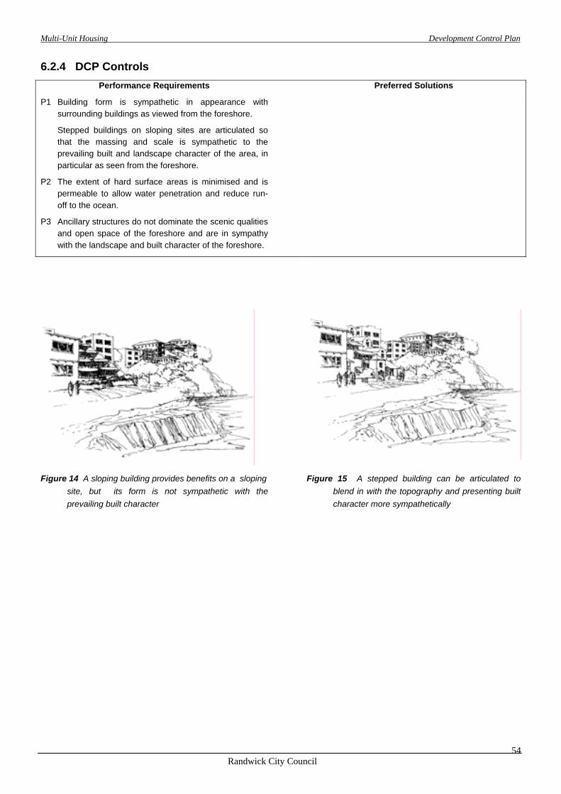
P1 Building form is sympathetic in appearance with surrounding buildings as viewed from the foreshore.
Stepped buildings on sloping sites are articulated so that the massing and scale is sympathetic to the prevailing built and landscape character of the area, in particular as seen from the foreshore.
P2 The extent of hard surface areas is minimised and is permeable to allow water penetration and reduce run-off to the ocean.
P3 Ancillary structures do not dominate the scenic qualities and open space of the foreshore and are in sympathy with the landscape and built character of the foreshore.
Figure 14 A sloping building provides benefits on a sloping site, but its form is not sympathetic with the prevailing built character
Figure 15 A stepped building can be articulated to blend in with the topography and presenting built character more sympathetically
Multi-Unit Housing Development Control Plan
Randwick City Council
55
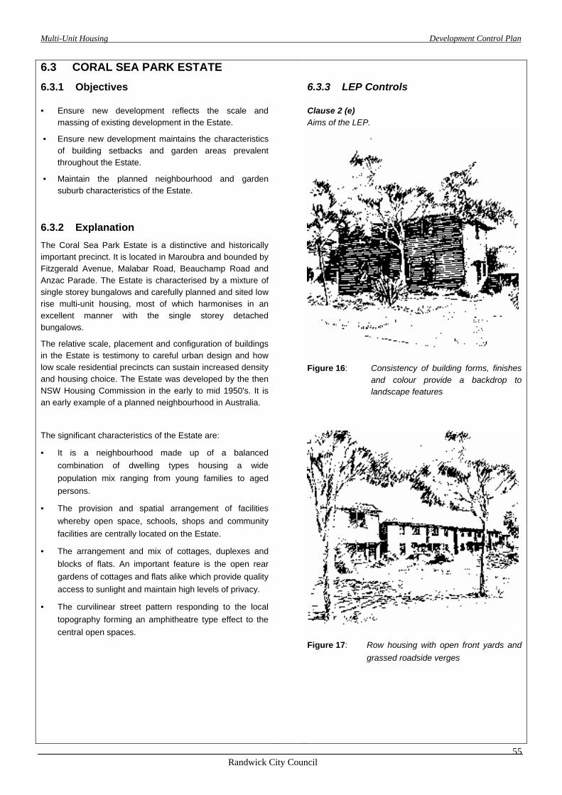
6.3 CORAL SEA PARK ESTATE
6.3.1 Objectives 6.3.3 LEP Controls
Clause 2 (e) Aims of the LEP.
• Ensure new development reflects the scale and massing of existing development in the Estate.
• Ensure new development maintains the characteristics of building setbacks and garden areas prevalent throughout the Estate.
• Maintain the planned neighbourhood and garden suburb characteristics of the Estate.
6.3.2 Explanation The Coral Sea Park Estate is a distinctive and historically important precinct. It is located in Maroubra and bounded by Fitzgerald Avenue, Malabar Road, Beauchamp Road and Anzac Parade. The Estate is characterised by a mixture of single storey bungalows and carefully planned and sited low rise multi-unit housing, most of which harmonises in an excellent manner with the single storey detached bungalows.
The relative scale, placement and configuration of buildings in the Estate is testimony to careful urban design and how low scale residential precincts can sustain increased density and housing choice. The Estate was developed by the then NSW Housing Commission in the early to mid 1950's. It is an early example of a planned neighbourhood in Australia.
Figure 16: Consistency of building forms, finishes
and colour provide a backdrop to landscape features
The significant characteristics of the Estate are:
• It is a neighbourhood made up of a balanced combination of dwelling types housing a wide population mix ranging from young families to aged persons.
• The provision and spatial arrangement of facilities whereby open space, schools, shops and community facilities are centrally located on the Estate.
• The arrangement and mix of cottages, duplexes and blocks of flats. An important feature is the open rear gardens of cottages and flats alike which provide quality access to sunlight and maintain high levels of privacy.
• The curvilinear street pattern responding to the local topography forming an amphitheatre type effect to the central open spaces.
Figure 17: Row housing with open front yards and
grassed roadside verges

Multi-Unit Housing Development Control Plan
Randwick City Council
56
6.3.4 DCP Controls
Performance Requirements Preferred Solutions
P1 Building materials and external finishes are consistent with the dominant themes in the Estate.
P2 Site area and dimensions, particularly width, are of sufficient size to allow and maintain the existing themes of large rear garden areas and open spaces between buildings to continue.
S2 Sites have a minimum frontage of 20 metres for development of more than 2 dwellings.
P3 Open spaces in front of buildings are not fenced off from the street. Where fencing is proposed it is no more than one metre high.
Figure 18: The estate is typified by simple buildings in a landscape setting
Figure 19: Residential flat buildings with similar form, roof pitch, material finishes and colour as other housing of the estate
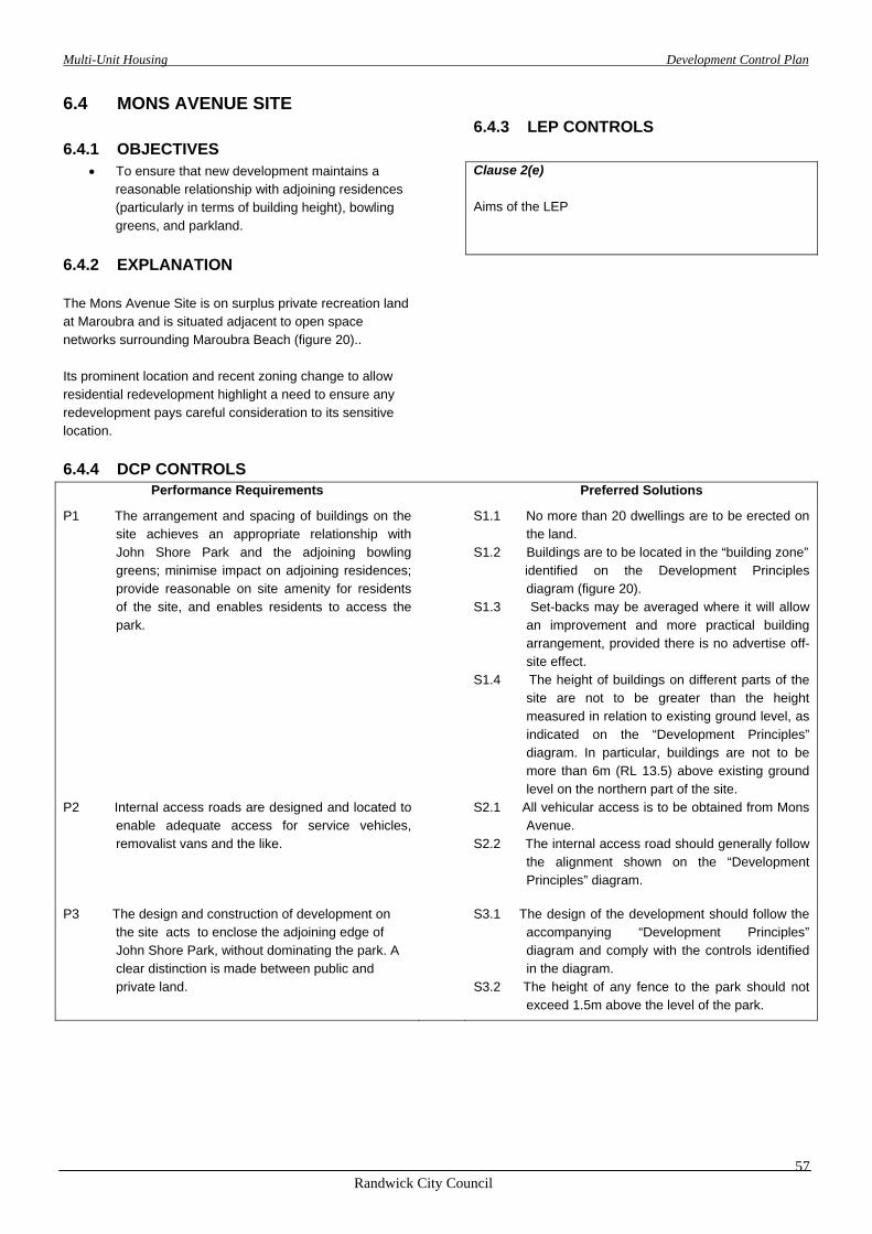
Multi-Unit Housing Development Control Plan
Randwick City Council
57
6.4 MONS AVENUE SITE
6.4.1 OBJECTIVES
6.4.3 LEP CONTROLS
• To ensure that new development maintains a reasonable relationship with adjoining residences (particularly in terms of building height), bowling greens, and parkland.
Clause 2(e) Aims of the LEP
6.4.2 EXPLANATION The Mons Avenue Site is on surplus private recreation land at Maroubra and is situated adjacent to open space networks surrounding Maroubra Beach (figure 20).. Its prominent location and recent zoning change to allow residential redevelopment highlight a need to ensure any redevelopment pays careful consideration to its sensitive location.
6.4.4 DCP CONTROLS
Performance Requirements Preferred Solutions
P1 The arrangement and spacing of buildings on the site achieves an appropriate relationship with John Shore Park and the adjoining bowling greens; minimise impact on adjoining residences; provide reasonable on site amenity for residents of the site, and enables residents to access the park.
S1.1 No more than 20 dwellings are to be erected on the land.
S1.2 Buildings are to be located in the “building zone” identified on the Development Principles
diagram (figure 20). S1.3 Set-backs may be averaged where it will allow
an improvement and more practical building arrangement, provided there is no advertise off-site effect.
S1.4 The height of buildings on different parts of the site are not to be greater than the height measured in relation to existing ground level, as indicated on the “Development Principles” diagram. In particular, buildings are not to be more than 6m (RL 13.5) above existing ground level on the northern part of the site.
P2 Internal access roads are designed and located to enable adequate access for service vehicles, removalist vans and the like.
S2.1 All vehicular access is to be obtained from Mons Avenue.
S2.2 The internal access road should generally follow the alignment shown on the “Development Principles” diagram.
P3 The design and construction of development on the site acts to enclose the adjoining edge of John Shore Park, without dominating the park. A clear distinction is made between public and private land.
S3.1 The design of the development should follow the accompanying “Development Principles” diagram and comply with the controls identified in the diagram.
S3.2 The height of any fence to the park should not exceed 1.5m above the level of the park.

Multi-Unit Housing Development Control Plan
Randwick City Council
58
Figure 20: Mons Avenue: Development Principles Diagram.

Multi-Unit Housing Development Control Plan
Randwick City Council
59
G:\TOWN\WP\DCPS\MUH-DCP\tableversion-muhdcp.doc fixed version.doc


