18


DEVELOPMENT CONTROL PLAN NO. 12
CONFLICTING LAND USES CITATION This plan may be cited as ‘Development Control Plan No. 12 - Conflicting Land Use Buffers’. AIMS AND OBJECTIVES The aim of this plan is to minimize the potential for conflict between residences and existing land uses likely to produce noise, odour, dust and other nuisance or pollution conflicts. Examples of these types of uses are abattoirs, large sawmills, quarries, stock dip sites and sewerage treatment works. TERMS USED BY COUNCIL Protected Land Use - Refers to the existing land use, development or activity identified in Schedule 1 of this plan and illustrated on the attached maps, which is the focus of a buffer and benefits from the provisions of this plan. Buffer - Refers to the area surrounding the protected land use, designated by this plan using a radial width in metres from the protected land use as defined on the maps attached to this plan. Nuisance Emissions - Refers to emissions of noise, vibration, smell, fumes, smoke, vapour, steam, soot, ash, dust, waste water, waste products or grit, oil or otherwise. PROVISIONS OF THE PLAN 1. This plan provides that within the areas nominated as ‘buffers’ around a protected land use, Council:- (a) will not consent to the erection of a dwelling on land within or affected by the buffer unless the dwelling is sited so as to minimize the potential impact of nuisance arising from the protected land use and proper consideration of measures to minimize conflict has taken place; (b) will consider other permissible non-residential land uses, development or building proposals on their merits and will only consent to the proposal where it has assessed the compatibility of that proposed use, activity or structure with the protected land use and determined that the establishment of that use, activity or structure within the buffer is acceptable; (c) will not permit any rezoning or amendment to a planning instrument relating to land within or affected by a buffer that will result in an increase in the residential occupation or use of that land. Any application for variation from this plan will need to be supported by appropriate environmental study; (d) will consider other non-residential land use rezonings or amendments on their merits and will only support such proposals where it has assessed the compatibility of the proposed zone, uses, activities or structures with the protected land use and determined that the implementation of that zone or amendment and the establishment of permissible developments resulting from the zoning are acceptable.
2
2. The lands subject to the provisions of this plan are identified by Schedule 1 and a series of maps attached to this plan. 3. The distances selected for buffers will be kept to a minimum by Council and development, building, or rezoning proposals seeking to encroach into the edge of a buffer will be treated the same as proposals further in or near the centre of the buffer. 4. The use of minimum distances for buffers will mean that nuisance emissions from a protected land use will likely occur outside of the buffer and persons residing outside of buffers should not expect nil nuisance from the protected land use. 5. The provisions of Kempsey Shire Council’s Tree Preservation Order are to apply to protected sites and buffer affected lands identified in Plans No. 1, 2, 4A and 4B. The retention of vegetation within a buffer is desirable to minimize visual impacts and ensure that any ancillary benefits for example small reductions in odour or noise transmissions are not lost through land clearing activities. CRITERIA FOR INCLUSION In assessing whether to include an existing land use, development or activity within this Development Control Plan and providing therein protection by way of a ‘buffer’ and where the ‘buffer’ will encroach upon adjoining lands in different ownership, Council shall consider the following:- (a) the previous long term use of the site and the potential long term continuation of the land use, development or activity; (b) the likely nature of and potential for conflict if dwelling houses are permitted in close proximity to or within the sphere of influence of nuisance emissions from the subject site; (c) the burden any such buffer would place on the ability of adjoining lands. Particularly their ability to accommodate a single dwelling house outside of the buffer; (d) any history of complaints; (e) the size, scale and nature of the activity; (f) whether the existing land use, activity or development is of local, shire, regional or state significance and the impact its closure or cessation might have on employment opportunities and the economy of the Shire or locality; (g) the identification of a reasonable buffer distance in terms of the particular nuisance being submitted for example odour, fumes, noise, dust and so on; (h) the extent to which the owners, operators and or managers have endeavoured to reduce emissions from the site and proposed measures to further improve the facility to reduce the impact of nuisance emissions. It should be noted that the establishment of a buffer will not be accepted as a substitute for proper management, maintenance and continued efforts to minimize any nuisance resulting from the land-use, activity or development.
3

DEPARTMENTAL RESPONSIBILITIES Operations Department Assessment of sites for inclusion and determination of buffer widths to be done in consultation with the Environmental Health and Development Department. Assessment of applications for rezoning or L.E.P. amendments for land affected by this plan. Environmental Health and Development Department Day to day administration of the plan in relation to development and building applications. Reports to Council on variations from the plan to be done in consultation with Strategic Planner.
SCHEDULE 1
Subject Site Property Description Average Buffer Width Frederickton Abattoirs Lot 1713, DP 717943
Parish Yarrabandinni As per plan
Kempsey Timbers Sawmill Lot B DP 8379
Armidale Road Parish Yarravel
As per plan
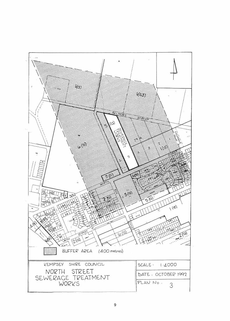
North Street Sewerage Treatment Works
Lots 5/6, Sec 29A North Street West Kempsey
400m
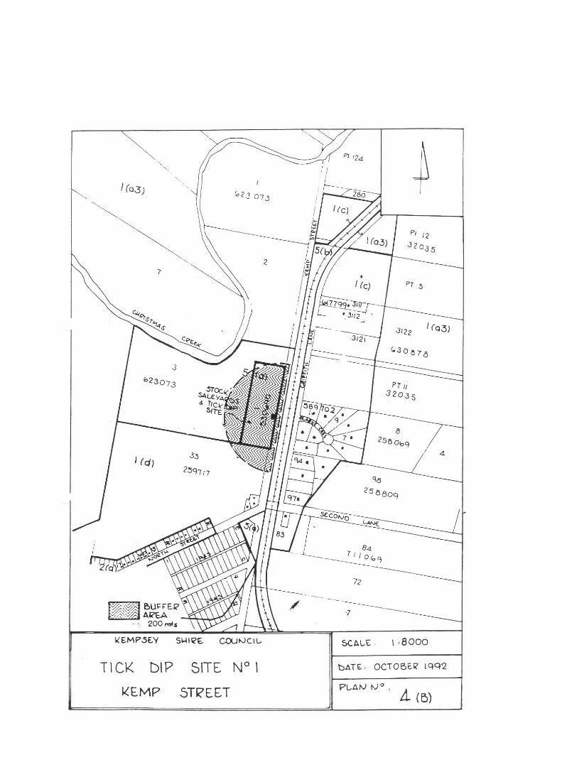
Stock and Saleyards (Tick Dip Site 1)
Lot 1 DP 530690 (Pt Por 28) and Closed Road, Parish West Kempsey
200m
Central Garbage Depot Por 2234 and Reserve No.
210024, Crescent Head Road Parish Beranghi
750m
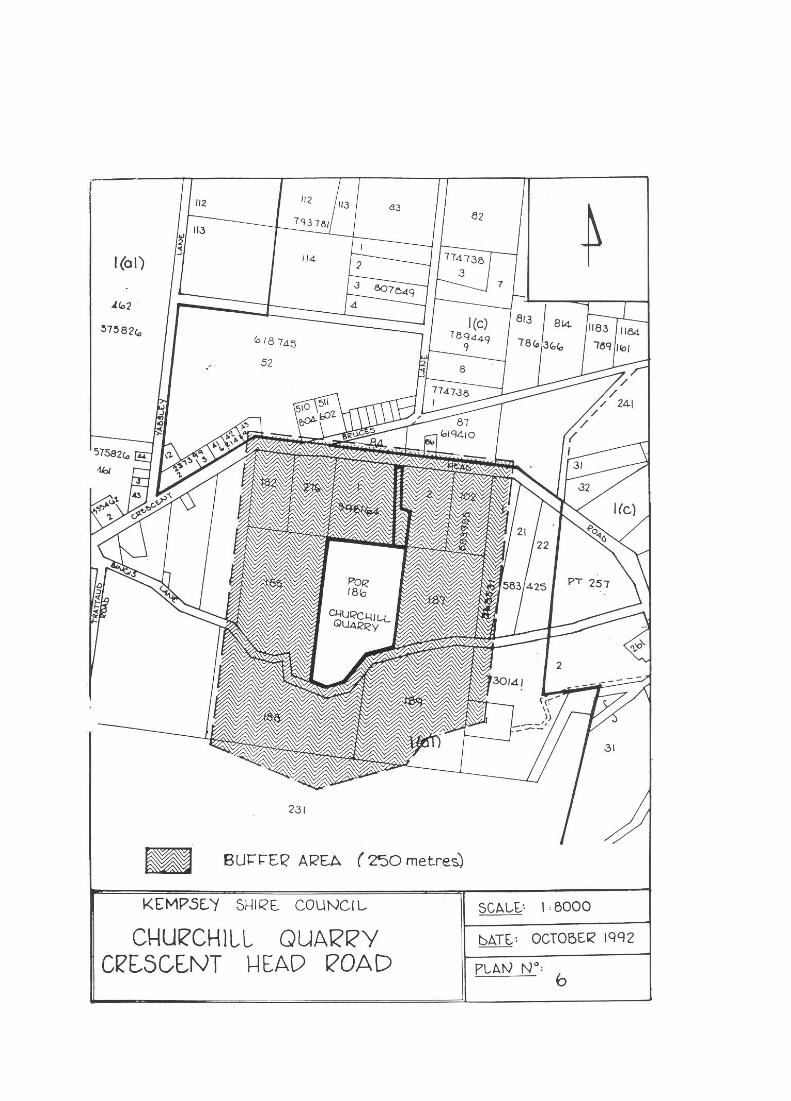
Churchill Quarry Pors 185/189 and Pt 183
Parish Beranghi 250m
Tick Dip Site 2 Lot 18 DP 749161
Parish Kullatine 200m
Tick Dip Site 3 Lot 29 DP 752419
Parish Kullatine 200m
Tick Dip Site 4 Lot 119 DP 752406
Parish Burragong 200m
4

5

6

7

8
9