Development Mechanism of Heavy Rai nfall over Gangneung Associated with Typhoon RUSA Tae-Young Lee, Nam-San Cho, Ji-Sun Kang Kun-Young Byun, Sang Hun Park Laboratory for Atmospheric Modeling Research (LAMO R) Dept. of Atmospheric Sciences, Yonsei University, Seoul 5 th International Conference on Mesoscale Meteorology and Typhoo n, 31 Oct.-3 Nov. 2006, Boulder, Colorado AMOP
Transcript
Development Mechanism of Heavy Rainfall over Gangneung Associated with
Typhoon RUSA
Tae-Young Lee, Nam-San Cho, Ji-Sun KangKun-Young Byun, Sang Hun Park
Laboratory for Atmospheric Modeling Research (LAMOR)Dept. of Atmospheric Sciences, Yonsei University, Seoul
5th International Conference on Mesoscale Meteorology and Typhoon, 31 Oct.-3 Nov. 2006, Boulder, Colorado
AMOP
Typhoon Rusa’s track and rainfall
0420 UTC 1. Sep990 hPa, 18m/ s
0630 UTC 31 Aug.960 hPa, 35m/ s
0000 UTC 23 Aug.
0000 UTC 29 Aug.950hPa, 41m/ s
• RUSA resulted in a record-breaking daily rainfall amount of 870.5 mm at Gangneung on 31 August 2002
• RUSA claimed 236 deaths & properties of about 6.1 Bill. Dollar
GangNeung
Terrain and location of stations
• Daegwallyeong - Near the mountain peak - 712.5 mm/day (31 Aug) • GangNeung - Relatively flat area near the coastline - Maximum daily precip. : 870.5 mm/day (31 Aug) (record)
Gangneung(GN)
Daegwallyeong (DGL)
Donghae(DH)
Sokcho (SC)
Height (m)
Kang and Lee (2004) suggested that direct terrain effect alone could not explain the heavy rainfall at Gangneung
Other studies related low-level convergence to the heavy rain at Gangneung, with terrain as a possible cause for the convergence
Mechanism of the rainfall at Gangneung is still not well understood
The heavy rainfall has not been successfully simulated by models. Why?
Previous studies
Goals and contents
• Goal - To explain the mechanism of the record-breaking heav
y rainfall at Gangneung associated with typhoon Rusa of 31 August 2002
• Contents - Observational analysis of the event - Preliminary numerical experiments - Analysis of results
Observational analysis
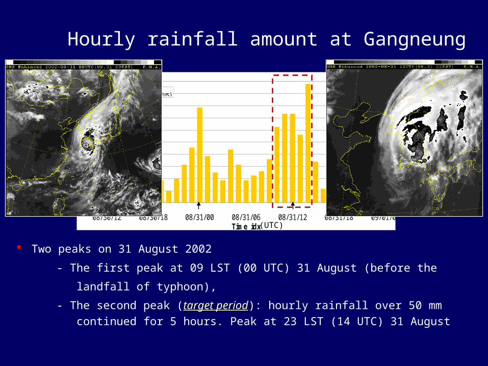
Two peaks on 31 August 2002
- The first peak at 09 LST (00 UTC) 31 August (before the
landfall of typhoon),
- The second peak (target periodtarget period): hourly rainfall over 50 mm continued for 5 hours. Peak at 23 LST (14 UTC) 31 August
Possible causes for the presence of N or NW winds at Gangneung and Sokcho :
• blocking of low-level NE flow by mountain range• local cooling of low level air along the east coast → pressure increase along the mountain slope → deceleration of winds toward the mountain range → ageostrophic northerly • magnitude changes of surface friction into the land
Preliminary Numerical Experiment
Experimental design• Model: WRF (V2.1.2)• Integration period: 00 UTC 31 Aug – 00 UTC 1 Sep 2002• 1-way nesting
Domain1 (D1)
Domain2 (D2)
Domain3 (D3)
Domain4 (D4)
Horizontal grid spacing
30km(191X171)
10km(190X181)
3.3km(217X199)
1.1km(271X298)
Vertical layers
33 layers (model top : 50hPa)
Cumulus Betts-Miller_Janjic No cumulus
Microphysics WSM 6 microphysics
LW radiation RRTM scheme
SW radiation Dudhia scheme
PBL Mellor-Yamada-Janjic TKE scheme
Surface Thermal diffusion scheme
Sea level pressure for 12 UTC 31 Aug 2002
CONT OBS
Simulated typhoon track and pressure distributionagree well with observation.
Simulated and observed surface-air temperature at Gangneung
31/
Gangneung
15
16
17
18
19
20
21
22
23
24
25
00 03 06 09 12 15 18
Time (UTC)
Tem
pera
ture
(°C
)
OBS
CONT
GDAS
Froude Number
Time Observation Simulation
06 UTC 31 0.69 1.52
12 UTC 31 0.77 3.13
Simulations with other models, initial and boundary conditions
Numerical models• Weather Research and Forecasting (WRF) model V2.1.2• PSU/NCAR Mesoscale Model (MM5) V3.7• CSU Regional Atmospheric Modeling System (RAMS) V4.4
Initial and boundary conditions from:• NCEP GDAS• KMA GDAPS
Integration periods:• 24hr (00 UTC 31 Aug – 00 UTC 1 Sep 2002)• 36hr (12 UTC 30 Aug – 00 UTC 1 Sep 2002)
All simulations failed to reproduce observations at and to the north of Gangneung
Possible causes for failure
• Errors in the initial conditions over the East Sea and coastal area
• Errors in boundary conditions (e.g., SST, surface roughness)
Summary (1)
• Heavy rainfall of 31 August 2002 at Gangneung (GN) is being examined using observation and numerical experiments.
• A band of strong rainfall develops along the mountain range as easterly associated with the typhoon Rusa blows toward the range.
• The band development is limited to GN and to its south during the heavy rainfall period at GN.
• Low-level N or NW winds prevail at GN and to its north as strong easterlies are found at higher levels.
• The presence of N - NW winds at low level to the north of GN appears to be a key factor for the heavy rainfall at GN.
Summary (2)
• Models have successfully reproduced the propagation of typhoon Rusa across the Korean peninsula, but not the heavy rain at Gangneung.
• N or NW winds at Gangneung and to its north are not simulated.
• Froude number of simulated flows toward the mountain range are significantly higher than the observation due to higher low-level temperature.
• Simulations using other models and initial conditions failed to reproduce observation at GN and in the area to its north.