REPORT OF THE SECRETARY OF NATURAL RESOURCES DEVELOPMENT OF A STRATEGY TO COLLECT DATA PERTAINING TO VOLUNTARY AGRICULTURAL AND FORESTRY BEST MANAGEMENT PRACTICES TO THE GOVERNOR AND THE CHAIRMEN OF THE SENATE AGRICULTURE, CONSERVATION AND NATURAL RESOURCES COMMITTEE; AND THE HOUSE AGRICULTURE, CHESAPEAKE AND NATURAL RESOURCES COMMITTEE COMMONWEALTH OF VIRGINIA RICHMOND NOVEMBER 2010
Transcript
REPORT OF THE SECRETARY OF NATURAL RESOURCES DEVELOPMENT OF A STRATEGY TO COLLECT DATA PERTAINING TO VOLUNTARY AGRICULTURAL AND FORESTRY BEST MANAGEMENT PRACTICES TO THE GOVERNOR AND THE CHAIRMEN OF THE SENATE AGRICULTURE, CONSERVATION AND NATURAL RESOURCES COMMITTEE; AND THE HOUSE AGRICULTURE, CHESAPEAKE AND NATURAL RESOURCES COMMITTEE
COMMONWEALTH OF VIRGINIA RICHMOND NOVEMBER 2010
Doug DomenechSecremry of Natural Resources
COMMONWEALTH of VIRGINIAOffice of the Governor
November 5, 2010
The Honorable Robert F. McDonnellGovernor, Commonwealth of VirginiaOffice of the GovernorPatrick Henry Building, 3rd FloorIIII East Broad StreetRichmond, Virginia 23219
The Honorable Patricia S. TicerChair, Senate Agriculture, Conservation andNatural Resources Committee30 I King StreetCity Hall, Room 2007Alexandria, Virginia 22314-3211
The Honorable Harvey B. MorganChair, House Agriculture, Chesapeake andNatural Resources CommitteeP.O. Box 949Gloucester, VA 23061
Re: Report on plans and resources necessary to establish a data collection system for agricultural andforestry best management practices (BMPs) implemented voluntarily as directed by 2010 Senate Bill346 and Code amendments to 2.2-220.3
Dear Governor McDonnell, Senator Ticer and Delegate Morgan:
I am pleased to submit the attached report in accordance with the action of the 2010 Virginia GeneralAssembly through Senate Bill 346 (Land conservation practices; information management), initiated by ChiefPatron Emmett W. Hanger, Jr. I encourage you to contact me directly should you have any questions or needsfor additional information with regards to the content of this report.
As always, I look forward to continuing to work with Governor McDonnell and his administration,and members of the legislature as we address these important matters.
Doug as omenechSecretary of Naturnl Resources
cc: Mr. Clyde CristmanMr. Paul Van Lenten
Patrick Henry Building· 1111 East Broad Street. Richmond, Virginia 23219 • (804) 786-0044 • Fax (B04) .171-8333 • TTY (800) 828-1120
PREFACE During the 2010 session of the Virginia General Assembly, Senator Emmett W. Hanger, Jr. served as chief patron of Senate Bill 346 (SB 346 Land conservation practices; information management.). The bill requires the Secretary of Natural Resources, with assistance from the Secretary of Agriculture and Forestry, to establish and maintain a database of the critical data attributes for onsite best management practices that limit the amount of nutrients and sediment entering state waters. The database is intended to document voluntary actions taken by the agricultural and silvicultural sectors and should enable the application of the collected data towards projections of progress towards meeting Virginia's water quality goals. The bill declares that an emergency exists and that the bill is effective upon passage. Virginia Secretary of Natural Resources, Douglas Domenech, in consultation with Secretary of Agriculture and Forestry, Todd Haymore, directed the Department of Conservation and Recreation (DCR) to establish a steering committee to assist with development of an appropriate strategy for data collection, use and maintenance of that data, with projections of resources needed. DCR Director David A. Johnson established the committee with the following members: Virginia Farm Bureau Federation, Wilmer Stoneman Virginia Agribusiness Council, Katie Frazier Virginia Association of Soil & Water Conservation Districts, Ed Overton and Meaghann Terrien Virginia Grain Producers Association, Molly Pugh Virginia Cattlemen’s Association, Bill McKinnon Virginia State Dairymen’s Association, Eric Paulson Virginia Poultry Federation, Hobey Bauhan Virginia Forestry Association, Paul Howe Virginia Loggers Association, Jim Mooney USDA NRCS, Jack Bricker and Wade Biddix USDA National Agricultural Statistics (NASS), Herman Ellison and David Mueller USDA FSA, Mike Wooden and Emily Horsley Virginia Cooperative Extension and Virginia Tech, Brian Benham Chesapeake Bay Foundation, Ann Jennings and Kristen Hughes Virginia DCR, Chair Jack Frye, Mark Meador, Joan Salvati, Bill Keeling and Stephanie Martin Supporting agencies: Virginia Department of Agriculture and Consumer Services, Perida Giles and Darrell Marshall Virginia Department of Forestry, Brad Williams and Matt Poirot Virginia Department of Environmental Quality, Neil Zahradka In keeping with the directive and on behalf of the Secretary of Natural Resources, DCR is providing this report to the Governor and the chairmen of the House Committee on Agriculture, Chesapeake and Natural Resources and Senate Committee on Agriculture, Conservation and Natural Resources.
EXECUTIVE SUMMARY The 2010 Virginia General Assembly charged the Secretary of Natural Resources (SNR) to submit a report by November 1, 2010 to the Governor and the chairmen of the House Agriculture, Chesapeake and Natural Resources Committee and the Senate Agriculture, Conservation and Natural Resources Committee on the approach and costs of establishing and maintaining a database of the voluntary agricultural and forestry best management practices (BMPs) implemented by the state’s agricultural and silvicultural producers (see Senate Bill 346). Under the direction of SNR Douglas Domenech, Virginia Department of Conservation and Recreation (DCR) established an ad-hoc advisory committee comprised of diverse representation of agricultural groups, organizations and agencies (see Preface for membership). DCR staff and members of the advisory committee reached consensus on fix criteria for collection and reporting of the voluntary agricultural and forestry BMPs:
1. The data to be collected will be limited to the list of BMPs that are recognized and accepted by EPA for Chesapeake Bay and other impaired waters with Total Maximum Daily Loads (TMDLs). (See Table 1 of this report)
2. All voluntary agricultural BMPs must meet the required USDA Natural Resources Conservation Service (NRCS) standards and specifications, for agricultural BMPs or Virginia Department of Forestry (VDOF) standards and specifications for Forest Harvesting BMPs and their existence must be field verified, to be reported for modeling purposes.
3. The staff of Virginia’s 47 soil and water conservation districts (SWCDs) will be the primary mechanism for collection and entry of voluntary agricultural BMP data. VDOF will collect and report voluntary forestry BMP data through a cooperative agreement with DCR in a format that will be mutually agreed upon to meet the requirements of the National Environmental Information Exchange Network (NEIEN).
4. DCR’s web based Agricultural BMP Tracking Program (Tracking Program) currently used by all SWCDs will be the data entry and storage system for voluntary agricultural BMPs.
5. VDOF is currently in the process of automating the forest harvesting BMP monitoring database and this system will be developed in a format compatible with the DCR Agricultural BMP Tracking Program for reporting consistency.
DCR staff and members of the advisory committee also reached consensus on a multi-phased approach to implementation of a system to collect, store and report voluntary agricultural and forestry BMPs. The success of this strategy is not only dependent upon support for the identified resource needs, it is also dependent upon collaboration and support by the agencies and organizations that participated in the study and shaped the path that is being taken.
2
Preliminary actions (Prior to July 1, 2011): To the extent time and resources allow, DCR staff will:
Continue to pursue collection of agricultural BMP data through the USDA Farm Services Agency (FSA) and data collected by the National Agricultural Statistics Service (NASS) for possible reporting purposes
Work with SWCDs and others, to resolve the six pilot districts that will collect and enter voluntary BMP data in FY12, ready those selected SWCDs to prepare to employ a dedicated resource to advance data collection and data reporting
Draft protocols to address topics that include data collection, BMP verification, land owner approval for collection/reporting, spot check procedures, data entry, and other needed guidance
In consultation with experts in data collection and data management, determine the needed revisions to the Agricultural BMP Tracking Program to streamline and accelerate data entry by SWCDs
Convene one or more meetings of the SWCD Tracking Program “user’s group” to ensure revisions to the Tracking Program are aligned with the needs of program users
Phase 1 (July 1, 2011 through June 30, 2012): Resources are detailed through this report to enable revisions to the Tracking Program for accommodation of voluntary BMP data; the establishment of an employee or contract position at DCR dedicated to data management and support of voluntary BMP data; and the support for additional agricultural conservation specialists capacity at six SWCDs to pilot data collection, entry and reporting. Provision of resources on or before July 1, 2011 will enable these actions to be achieved during the 2012 fiscal year (July 1, 2011 through June 30, 2012). Reportable data will be collected during this phase. Phase 2 (July 1, 2012 through June 30, 2013): DCR, in consultation with SWCDs, the Virginia Association of SWCDs, VDOF and others, will assess the needs for additional funding. Priority will be given to the collection of data that will enable Virginia to address Chesapeake Bay TMDL needs. In the Southern Rivers portion of the state, priority will be placed on data that will help address impaired TMDL targeted waters. Given these priorities, consideration will be given to the needs for technical assistance capacity at districts across the state. In addition, the costs associated with a marketing/outreach plan that will target agricultural producers with appropriate messages pertaining to the reporting of voluntary agricultural and forestry BMPs will be determined along with other critical expenses that are necessary to the effective implementation of agricultural and forestry data collection. On or before November 1, 2011, DCR will report these funding needs to the Governor and the chairmen of the House Committee on Agriculture, Chesapeake and Natural Resources and Senate Committee on Agriculture, Conservation and Natural Resources. Funds made available for these purposes will make possible the full implementation of this statewide approach for the collection, data entry and reporting of voluntary BMP data by all SWCDs during the 2013 fiscal year (July 1, 2012 through June 30, 2013).
3
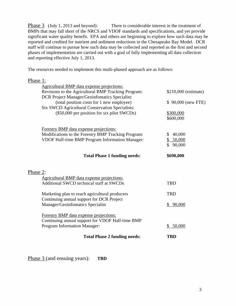
Phase 3 (July 1, 2013 and beyond): There is considerable interest in the treatment of BMPs that may fall short of the NRCS and VDOF standards and specifications, and yet provide significant water quality benefit. EPA and others are beginning to explore how such data may be reported and credited for nutrient and sediment reductions in the Chesapeake Bay Model. DCR staff will continue to pursue how such data may be collected and reported as the first and second phases of implementation are carried out with a goal of fully implementing all data collection and reporting effective July 1, 2013. The resources needed to implement this multi-phased approach are as follows: Phase 1: Agricultural BMP data expense projections: Revisions to the Agricultural BMP Tracking Program: $210,000 (estimate) DCR Project Manager/Geoinfomatics Specialist: (total position costs for 1 new employee) $ 90,000 (new FTE) Six SWCD Agricultural Conservation Specialists: ($50,000 per position for six pilot SWCDs) $300,000 $600,000 Forestry BMP data expense projections: Modifications to the Forestry BMP Tracking Program: $ 40,000 VDOF Half-time BMP Program Information Manager: $ 50,000 $ 90,000
Total Phase 1 funding needs: $690,000 Phase 2: Agricultural BMP data expense projections: Additional SWCD technical staff at SWCDs TBD Marketing plan to reach agricultural producers TBD Continuing annual support for DCR Project Manager/Geoinfomatics Specialist $ 90,000 Forestry BMP data expense projections: Continuing annual support for VDOF Half-time BMP
Program Information Manager: $ 50,000 Total Phase 2 funding needs: TBD Phase 3 (and ensuing years): TBD
4
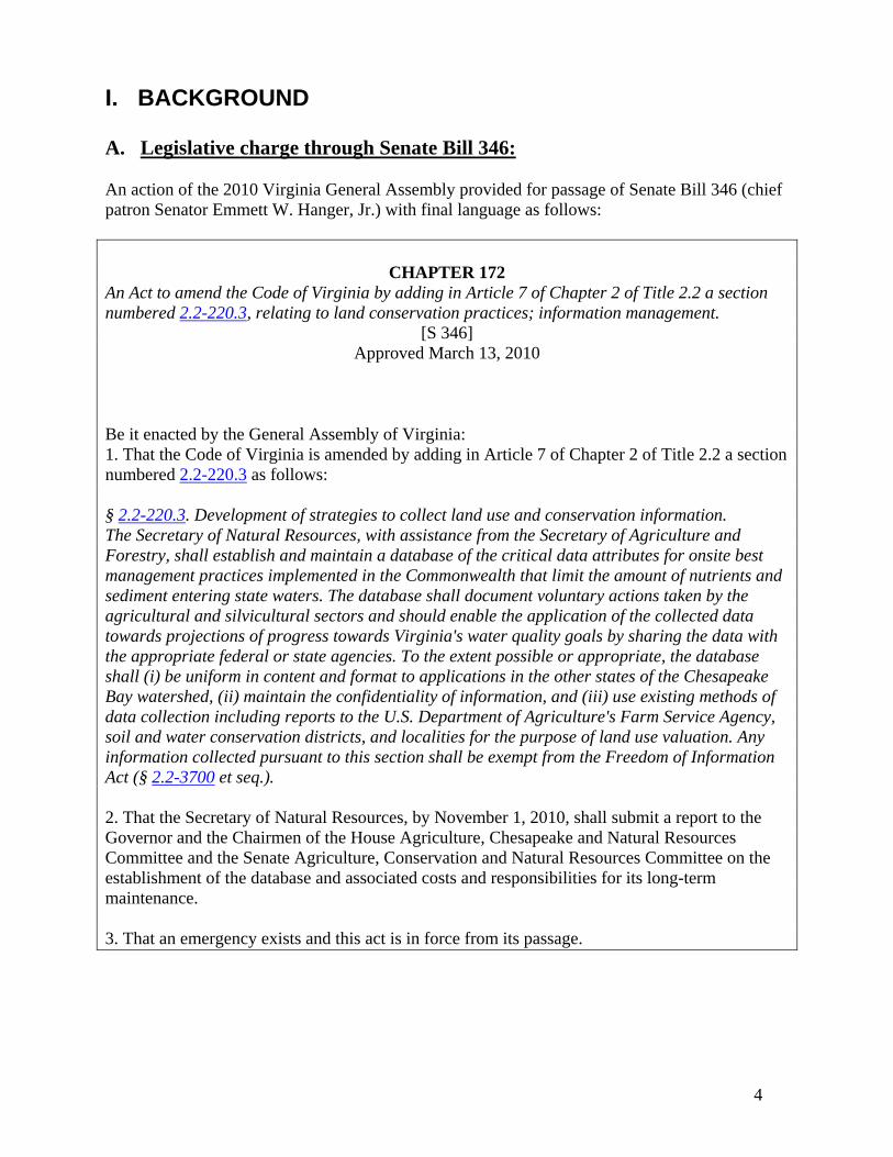
I. BACKGROUND A. Legislative charge through Senate Bill 346: An action of the 2010 Virginia General Assembly provided for passage of Senate Bill 346 (chief patron Senator Emmett W. Hanger, Jr.) with final language as follows:
CHAPTER 172 An Act to amend the Code of Virginia by adding in Article 7 of Chapter 2 of Title 2.2 a section numbered 2.2-220.3, relating to land conservation practices; information management.
[S 346] Approved March 13, 2010
Be it enacted by the General Assembly of Virginia: 1. That the Code of Virginia is amended by adding in Article 7 of Chapter 2 of Title 2.2 a section numbered 2.2-220.3 as follows: § 2.2-220.3. Development of strategies to collect land use and conservation information. The Secretary of Natural Resources, with assistance from the Secretary of Agriculture and Forestry, shall establish and maintain a database of the critical data attributes for onsite best management practices implemented in the Commonwealth that limit the amount of nutrients and sediment entering state waters. The database shall document voluntary actions taken by the agricultural and silvicultural sectors and should enable the application of the collected data towards projections of progress towards Virginia's water quality goals by sharing the data with the appropriate federal or state agencies. To the extent possible or appropriate, the database shall (i) be uniform in content and format to applications in the other states of the Chesapeake Bay watershed, (ii) maintain the confidentiality of information, and (iii) use existing methods of data collection including reports to the U.S. Department of Agriculture's Farm Service Agency, soil and water conservation districts, and localities for the purpose of land use valuation. Any information collected pursuant to this section shall be exempt from the Freedom of Information Act (§ 2.2-3700 et seq.). 2. That the Secretary of Natural Resources, by November 1, 2010, shall submit a report to the Governor and the Chairmen of the House Agriculture, Chesapeake and Natural Resources Committee and the Senate Agriculture, Conservation and Natural Resources Committee on the establishment of the database and associated costs and responsibilities for its long-term maintenance. 3. That an emergency exists and this act is in force from its passage.
5
B. Existing data collection system for agricultural and forestry BMPs reported to EPA
BMPs that are implemented through incentive programs administered by DCR receive technical assistance from the state’s 47 Soil and Water Conservation Districts (SWCDs or districts). These incentive programs include the Virginia Agricultural BMP Cost-Share (VACS) Program, the state portion of incentives provided through the USDA Conservation Reserve Enhancement Program (CREP), and the Virginia Agricultural BMP Tax Credit Program. The authority for SWCD delivery of the VACS Program is established in state Code (§ 10.1-546.1. Delivery of Agricultural Best Management Practices Cost-Share Program). Since the 1980’s DCR has collected data pertaining to agricultural BMPs receiving state financial incentives and reported such information to the Environmental Protection Agency (EPA) for use in the Chesapeake Bay Watershed Model. DCR’s BMP data collection program relies upon the entry of specific data fields by all SWCDs. The program has evolved considerably over the past 20 plus years. In 2007 and 2009 the Virginia General Assembly authorized appropriations that total $1 million for the modernization of this data entry program. In September, 2009 the first phase of the new, web-based “Tracking Program” was launched by DCR for use by SWCDs across the commonwealth. For every BMP receiving state incentives, specific data fields are documented and connected to specific farms with precise location information. Currently the data fields enable automated projections of the impacts of the BMP with “edge of field” estimates of nonpoint source pollutant reductions for use with Chesapeake Bay and small watershed projects that address water quality impairments. These projects are more generally referenced as Total Maximum Daily Load or TMDL projects. Using existing appropriated funds, early in the 2010 calendar year, DCR initiated a second phase of improvements to the Tracking Program through a contract with WorldView, Inc., based in Richmond, Virginia. Completion of a comprehensive list of over 40 enhancements to the program occurred during October, 2010. The enhancements were driven by feedback from the Tracking Program users at SWCDs and DCR. Presently DCR is working closely with EPA and many Chesapeake Bay partners to ensure the commonwealth’s nonpoint source (NPS) BMP data complies with the National Environmental Information Exchange Network (NEIEN) NPS BMP schemas. Staff at DCR have worked closely with EPA, the Bay states and the District of Columbia to ensure consistency with the many factors that impact NPS BMP data reporting. Access to the existing Tracking Program is limited to SWCD and DCR staff. The program has “state of the art” security safeguards to maintain the confidentiality. The addition of data pertaining to the voluntary implementation of agricultural BMPs will be equally secure. Amendments to § 2.2-220.3. (effective July 1, 2010), which provides: “…Any information collected pursuant to this section shall be exempt from the Freedom of Information Act (§ 2.2-3700 et seq.).” are sufficient to restrict the release of such data.
6
The VDOF has been actively collecting field verified BMP implementation data on timber harvesting operations since 1995 and has an extensive database of voluntary forestry BMPs for operational forestry for that time period. In 2007, VDOF revised the voluntary forestry BMP monitoring protocol to comply with the monitoring criteria set out by the Southern Group of State Foresters and USDA Forest Service, Region 8. The protocol is acceptable to EPA. Currently, a new database system is under development to capture forestry BMPs for timber harvesting. Additional funding will be needed to complete this process and to allow the VDOF tracking system to meet the requirements for DCR reporting to the NEIEN network. Other BMP categories such as upland tree planting and Riparian Forest Buffer Establishment are currently being collected in the VDOF IFRIS system (Integrated Forest Resource Information System) and can easily be reported to DCR for reporting under the NEIEN. VDOF will need to develop a cooperative agreement with DCR to facilitate reporting requirements and agency reporting responsibilities for the voluntary forestry BMP reporting area. C. Approach taken to resolve the data collection strategy and resource needs: Under the direction of the Virginia Secretary of Natural Resources, Douglas Domenech, and the Virginia Secretary of Agriculture and Forestry, Todd Haymore, DCR Director, David A. Johnson established a working advisory committee with diverse agricultural and forestry interests to shape the path to be followed for data collection and needed resources. (See the Preface of this report for committee membership). DCR convened three meetings and a conference call (August 6, August 30, September 8 and October 6, 2010 conference call) of this ad-hoc advisory committee. Summaries of recorded notes and significant conclusions from each meeting are contained within the Appendix of this report.
7
II. FINDINGS, PLANNED APPROACH AND FUTURE RESOURCE NEEDS A. Findings: Consensus was reached by DCR staff and the ad-hoc advisory committee on the following four (4) points: 1) The data to be collected will be limited to the list of “reportable” BMPs that are recognized and accepted by EPA for inclusion in the Chesapeake Bay Watershed Model and other impaired waters with TMDL implementation projects. See Table 1. Within the table, Column 1 summarizes Virginia’s “five priority practices”, or more accurately the suite of BMPs that relate to groupings of priority practices. Column 2 shows the current comprehensive list of BMPs accepted by EPA for Chesapeake Bay modeling and other impaired waters. Column 3 reflects BMPs offered through the Virginia Agricultural BMP Cost-Share (VACS) Program as they relate to the 49 reportable practices. 2) To ensure EPA's requirement for reasonable assurance regarding reported BMPs, all voluntary agricultural and forestry BMPs that are reported must meet the practice standards and specifications (according to USDA NRCS requirements for agriculture and VDOF requirements for forestry) and all reported BMPs will be field verified using protocols currently in place for verifying implementation of BMPs funded through the Virginia Agricultural BMP Cost Share program. 3) For all agricultural BMPs and some forestry BMPs, Virginia’s 47 SWCDs will be the primary mechanism for the collection and reporting of the voluntary practices. Cooperation and assistance with other state agencies will be essential to collect BMP data. For example, assistance from the Virginia Department of Environmental Quality is necessary to ensure data on BMPs that are implemented to fulfill regulatory requirements for permitted farm operations will be captured. Similarly, cooperation and assistance by the Virginia Department of Agriculture and Consumer Services, through the Agricultural Stewardship Act, will help ensure BMPs implemented through corrective action when pollution complaints are founded, will be reported. The Virginia Department of Forestry will continue to capture and track creditable BMPs that pertain to forest harvesting upland tree planting and riparian forest buffer establishment. 4) DCR’s Agricultural BMP Tracking Program is the system SWCDs will use to enter data on reportable voluntary agricultural BMPs. The system will be modified to accept practices implemented voluntarily. Forestry BMPs will be directly reported to DCR through a system resolved with VDOF by mutual agreement.
8
Table 1. Creditable BMPs accepted by EPA for Chesapeake Band and TMDL reporting purposes:
Column 1
Column 2
Column 3
# BMP VACS BMP
1 Forest Buffers Riparian Cropland CRFR3, FR-3
2 Forest Buffers Riparian Hay CRFR3, FR-3
3 Forest Buffers Riparian Pasture CRFR3, FR-3
Grass/Forest buffers 4 Forest Buffers Riparian Total CRFR3, FR-3
28 Non Urban Stream Restoration (linft)* WP-2A, WP-2C
29 Mortality Composters WP-4C
30 Water Control Structures WQ-5
31 Horse Pasture Management SL-6A
32 Forest Harvesting Practices FR-4
33 Conservation Plan Cropland NA
34 Conservation Plan Hay NA
35 Conservation Plan Pasture NA
36 Poultry Litter Transport NA
37 Phytase (Poultry and Swine)** NA
38 Dairy Precision Feeding and Forage Management NA
39 Carbon Sequestration/Alternative Crops NA
40 Decision Agriculture NA
41 Enhanced Nutrient Management NA
42 Ammonia Emissions Reduction NA
43 Liquid Manure Injection NA
44 Poultry Litter Injection NA
45 Dirt and Gravel Road Erosion & Sediment Controls NA
46 Cropland Irrigation Management NA
47 Cropland Drainage Phosphorus-absorbing Materials (PSMs) NA
48 Mortality Incinerators NA
49 Vegetative Environmental Buffers (VEB) NA
9
B. Planned Approach –Multiple Phases:
DCR staff and the ad-hoc advisory committee also reached consensus on a multi-phased approach for full implementation of a system to collect data on agricultural and forestry BMPs implemented by the agricultural community without participation in state and federal incentive programs.
Preliminary actions : To the extent time and resources allow, DCR staff will:
Continue to pursue collection of agricultural BMP data through the USDA Farm Services Agency (FSA) and data collected by the National Agricultural Statistics Service (NASS) for possible reporting purposes
Work with SWCDs and others, to determine the six pilot districts that will collect and enter voluntary BMP data in FY12.
Begin development of protocols to address topics that include data collection, BMP verification, land owner approval for collection/reporting, spot check procedures, data entry, and other topics…
In consultation with experts in data collection and data management, determine the needed revisions to the Agricultural BMP Tracking Program to streamline and accelerate data entry by SWCDs
Convene one or more meetings of the SWCD Tracking Program “user’s group” to ensure revisions to the Tracking Program are aligned with the needs of program users
Phase 1: Resources needed to make required revisions to the Tracking Program and address DCR and VDOF staff resources are specified within the Future Resource Needs portion of this report.
The need for a dedicated resource at DCR to support and coordinate this work –especially the revisions to the Tracking program, is essential to the success of this strategy. This resource, whether the resource is a dedicated employee of DCR, or a resource established contractually by DCR, must perform the many tasks that are necessary to effectively collect, manage and report data on voluntary agricultural and forestry BMPs. The dedicated resource must be capable of performing the project management and administration requirements established by VITA (Virginia Information Technologies Agency). The resource must have or acquire an understanding of SWCDs and how their technical staff gather and input data. Furthermore this resource must understand databases, programming languages, GIS and complex automated systems. In the absence of this critical resource, DCR will not be successful in achieving the desired results this strategy sets forth.
10
With these resources, effective on or before July 1, 2011, DCR will undertake revisions to the Tracking Program and VDOF will effect changes to the forestry BMP monitoring program. Protocols for SWCD collection of data will be developed. A subset of six SWCDs will be selected to work closely with DCR to pilot farmer outreach and data collection. The SWCD users of the Tracking Program will ensure program revisions align with their needs. Equally important will be the assistance of these SWCD staff as the collection protocols are developed to ensure data collected in all SWCDs is consistently gathered and reported. DCR staff will work with VDOF staff to develop a reporting protocol for forestry BMPs during this same time period.
During the 2012 fiscal year, DCR will work closely with all SWCDs and their Association to determine the quantity of SWCD technical staff that will be needed to effectively gather data on the voluntary BMPs adopted by agricultural producers. BMPs implemented voluntarily come at no expense to state and federal incentive programs. A more comprehensive understanding of the true conservation treatment of the landscape should enable better projections of the BMPs that are needed to fulfill Chesapeake Bay and other TMDL agricultural BMP implementation commitments. Practices that meet standards and specifications and have been field verified by SWCD staff are comparable to BMPs implemented with state financial incentives. An overall reduction of agricultural BMPs that must be implemented through incentive programs is expected, resulting in an overall reduction of expense to achieve this important part of the commonwealth’s water quality strategies.
Phase 2: The needed resources to implement the second phase of the collection and reporting of voluntary agricultural and forestry data will be submitted to the Governor and the Chairmen of the House Agriculture, Chesapeake and Natural Resources Committee and the Senate Agriculture, Conservation and Natural Resources Committee, on or before November 1, 2011.
During the second phase of the implementation of this data collection strategy priority will be given to the collection of data that will enable Virginia to address Chesapeake Bay TMDL needs. In the Southern Rivers portion of the state, priority will be placed on data that will help address impaired TMDL targeted waters. Given these priorities consideration will be given to the needs for technical assistance capacity at districts across the state. In addition, the costs associated with a marketing/outreach plan that will target agricultural producers with appropriate messages pertaining to the reporting of voluntary agricultural and forestry BMPs will be determined along with other critical expenses that are necessary to the effective implementation of agricultural and forestry data collection. With resources provided through Phase 1, the second phase of this effort will begin July 1, 2012. In place at that time will be: A fully revised Tracking Program that will enable efficient data entry by SWCD staff across
the Commonwealth Modification of the VDOF forestry BMP monitoring system to be able to provide
information of voluntary forestry BMPs in a format consistent with DCR reporting needs. An employee at DCR that will oversee the data collection, reporting and administration of
such data A half time position at VDOF to oversee the data collection and reporting of all forestry
BMPs
11
Written protocols and guidance produced by DCR, issued and followed by the state’s 47 SWCDs
The ability of all SWCDs to enter data on voluntary agricultural and forestry practices to the extent staff that exist on July 1, 2011 have the available time to devote to such data collection and data entry and
A defined marketing plan to reach farmers and forest land owners with appropriate messages concerning the opportunity to report their BMPs and the water quality benefits of BMPs –implementation of the plan is subject to availability of funding. Reaching the land owners and managers that produce agricultural and silvicultural products will require support and assistance from organizations and associations that include:
Virginia Farm Bureau Federation Virginia Agribusiness Council Virginia Grain Producers Association Virginia Cattlemen’s Association Virginia State Dairymen’s Association Virginia Poultry Federation Virginia Forestry Association Virginia Loggers Association
The marketing plan will integrate strategies that capitalize on commitments from these important groups.
Phase 3: : There is considerable interest in the treatment of BMPs that may fall short of the NRCS and VDOF standards and specifications, and yet provide significant water quality benefit. EPA and others are beginning to explore how such data may be reported and credited for nutrient and sediment reductions in the Chesapeake Bay Model. DCR staff will continue to pursue how such data may be collected and reported as the first and second phases of implementation are carried out with a goal of fully implementing all data collection and reporting effective July 1, 2013.
12
C. Future Resource Needs –Multiple Phases
The associated costs for establishment and long term maintenance of the voluntary agricultural and forestry BMP data system are as follows:
_______________________
Phase 1 Resources Agricultural BMP data expense projections: Revisions to the Agricultural BMP Tracking Program: $210,000 (estimate) DCR Project Manager/Geoinfomatics Specialist: (total position costs for 1 new employee) $ 90,000 (new FTE) Six SWCD Agricultural Conservation Specialists: ($50,000 per position for six pilot SWCDs) $300,000 $600,000 Forestry BMP data expense projections: Modifications to the Forestry BMP Tracking Program: $ 40,000 VDOF Half-time BMP Program Information Manager: $ 50,000 $ 90,000 Total Phase 1 funding needs: $690,000
_______________________________
Phase 2 Resources Agricultural BMP data expense projections: Additional SWCD technical staff at SWCDs TBD Marketing plan to reach agricultural producers TBD Continuing annual support for DCR Project Manager/Geoinfomatics Specialist $ 90,000 Forestry BMP data expense projections: Continuing annual support for VDOF Half-time BMP
Program Information Manager: $ 50,000 Total Phase 2 funding needs: TBD
_______________________________
Phase 3 Resources TBD
DCR in consultation with SWCDs, the Virginia Association of SWCDs and others will assess the costs associated with the second and third phases of this initiative in the coming months. On or before November 1, 2011, DCR will report those costs to the Governor and the Chairmen of the House Agriculture, Chesapeake and Natural Resources Committee and the Senate Agriculture, Conservation and Natural Resources Committee.
13
Appendix
Summary of July 9th, 2010 Meeting of the Voluntary BMP Ag/Forestry Technical Advisory Committee
Attendees: Donna Dennehy, Va Thoroughbred Assoc.; Greg Scheerer, Va Forestry Assoc.; Ed Overton, VASWCD; Emily Horsley, USDA/FSA; Darrell Marshall, VDACS; Katie Frazier, Va Agribusiness Council; L.Wayne Kirby, Va Grain Producers Assoc.(VGPA); Eugene Longest, VGPA; Jack Bricker, USDA/NRCS; Brian Benham, Va Tech/BSE; Neil Zahradka, DEQ; Meaghann Terrien, Three Rivers SWCD; Matt Poirot, VDOF; Brad Williams, VDOF; Herman Ellison, NASS; Hobey Bauhan, Va Poultry Federation; Bill McKinnon, Va Cattlemen’s Assoc.; Wilmer Stoneman, Va Farm Bureau Federation; Kristen Hughes Evans, Chesapeake Bay Foundation; Jack Frye, DCR/SWC; Stephanie Martin, DCR/SWC; Bill Keeling, DCR/SWC; Joan Salvati, DCR/CBLA; Mark Meador, DCR/SWC Notes Transcribed From Flip Charts: Issues/Areas of concern: Duplication of reporting (potentially double, triple counting the same BMP) through USDA,
state reporting, voluntary reporting… Reporting regulatory practices such as CAFOs and associated BMPs –making sure all
implemented BMPs are reported Will the state collection system be available for access to determine data being reported? “Model Conflicts” (Chesapeake Bay Model) like land use inconsistencies Define the process for reporting by localities, NGOs and others Voluntary BMPs need to be a part of the Bay Watershed Implementation Plan (WIP) Consequences of voluntary reporting, will there be negative consequences when farmers
report? Va Dept of Forestry concern about retention of existing buffers Ideas/Approaches: Notion of using a “spot check” system for field verification of voluntary reported BMPs “system” for reporting should have aerial imagery where practice location is specified Need to examine existing systems for use such as Va Dept of Forestry’s data collection
system and the DCR/SWCD Ag BMP Tracking Program Farmer self reporting? Soil and Water Conservation Districts (SWCDs) perform farm assessments? Certified staff “certifying” certain BMPs (such as CCA –certified crop advisors; certified
Nutrient Management Planners and others) Need to educate and use communication to reach the agricultural community
14
Relying on trained staff (SWCD, CCAs and others) for recurring visits can give further lifespan info on BMPs
Web Based Farmer self reporting: Will require some quantity of trained staff to perform field assessments… Motivation by farmers to report is a question (Bay TMDL may “motivate”) Implementation of BMPs is tied to a conservation plan Will a web based system add to duplicative reporting of BMPs? According to NASS, 57% of farmers in Va have internet service; NASS estimates roughly
1% of farmers respond to internet based surveys Consider other multiple approaches to get BMP data like phone/mail out surveys… Use of existing systems for voluntary BMP collection –SWCDs and Ag BMP Tracking Program: SWCDs are statewide and have an existing, trained, technical work force Workload is down with much less agricultural BMP funding Use of the existing Tracking Program (with some modification) capitalizes on the $1M
investment in program modernization; SWCDs are familiar with the program and use Meeting Synopsis: Good attendance and participation by attendees representing a diversity of interests Jack/Mark framed the charge (Senator Hanger’s Bill #346) including a general timeline…
with a Nov 1st report, possible 2011 General Assembly action, expectations that any appropriated resources will be effective July 1, 2011… with work to begin
The majority of the group (perhaps a consensus) reached agreement that data to be collected is limited to just the BMPs that can be reported/modeled
Lots of open discussion about collecting data… farmer self reporting, SWCDs, CCAs, as possible options…
Lots of open discussion about data entry and automated systems… DCR’s Tracking Program, VDOF’s system
Acknowledgement by some that there is very little incentive (if any) for farmer self reporting of farm BMPs
Towards the close of discussion some movement towards SWCDs as the logical/appropriate tech resource and collection system
Next meeting will be held August 6th from 9:00 a.m. to 12:00 noon at the NRCS State Office in Richmond.
The 1st hour to demo VDOF/DCR systems; then resume discussion on how data will be gathered/reported and tracked.
15
Summary of August 6th, 2010 Meeting of the Voluntary BMP Ag/Forestry Technical Advisory Committee
Attendees: Paul Howe, Va Forestry Assoc.; Ed Overton, VASWCD; J.C. Berger, VASWCD; Perida Giles, VDACS; Katie Frazier, Va Agribusiness Council; L.Wayne Kirby, Va Grain Producers Assoc.(VGPA); Eugene Longest, VGPA; Jack Bricker, USDA/NRCS; Brian Benham, Va Tech/BSE; Neil Zahradka, DEQ; Meaghann Terrien, Three Rivers SWCD; Matt Poirot, VDOF; Brad Williams, VDOF; Herman Ellison, NASS; John Scrivani, VA VITA/VGIN; Chris Gerecke, Timmons Group; Jim Mooney, Va Loggers Assn.; Buck Kline, VDOF; Wilmer Stoneman, Va Farm Bureau Federation; Jack Frye, DCR/SWC; Stephanie Martin, DCR/SWC; Bill Keeling, DCR/SWC; Mark Meador, DCR/SWC Notes Transcribed From Flip Charts: Data collection (and other miscellaneous notes): SWCDs gather data from farms invited to report and those currently working with How to reach all farms?
There is need to ensure all permitted and offsets operations are reported/credited; DEQ assistances is needed
(Assumption) All BMPs reported are field verified (subject to revisit w/EPA including spot checks)
Feedback to farmers for reporting is needed (i.e. what benefit the reported BMPs achieve with nutrient/sediment reductions)
Perhaps a statewide “whole” picture report of BMPs (voluntary and other) to convey progress
VDOF logging notification system (a mandate/requirement exists for this) initial data entry “ques” VDOF staff to perform field assessments
Need for a marketing/PR campaign to convey reporting need/opportunity Farms not serviced by SWCDs are the challenge for voluntary BMP data Are there incentives/consequences for reporting? Table “incentives/penalties” and set aside until there is better understanding of farmer
response Need for a promotional campaign
o How?/Who? o Need for consistent message o Needs to be up front at the outset
16
Needs: Better integration of VDOF and DCR reporting systems for forestry BMPs Such as field plantings not cost-shared by DCR and SWCDs
Data Collection
Data Entry System
Ag BMPs and some forestry: SWCDs staff
DCR Ag BMP Tracking Program: SWCDs
Forestry BMPs: VDOF staff
VDOF Inforest: VDOF staff
Ag Stewardship: VDACS staff
Entry system TBD: ?
Permitted/Offsets farms: DEQ staff
Entry system TBD: ?
Meeting Synopsis (Key Points): This second meeting of the advisory group reflected good attendance and participation by
attendees representing a diversity of interests Jack/Mark recapped the last meeting and provided opportunity to amend the meeting notes.
No changes were requested. Two automated data collections systems were presented, VDOF’s Inforest program and
DCR’s Ag BMP Tracking program The majority of the group (perhaps a consensus) reached agreement that data to be collected
will be reported through the DCR Ag BMP Tracking program used by the state’s SWCDs. Modification to this program will be necessary to streamline the process SWCDs will follow for voluntary practice reporting
The group further settled on SWCDs as the collection system for voluntary agricultural and forestry BMP data
As with the first meeting of this group, there was much open discussion about how to reach a large number of farmers; a marketing/PR strategy and plan is needed
The group will revisit discussion topics that include: o Piloting voluntary BMP data collection vs. statewide rollout of a collection
system o Consideration of what feedback to provide to a farmer that allows BMPs to be
reported o Whether farmers must approve/authorize reporting of all farm BMPs o Resources that will be needed for the approach pursued o Pathways to collect BMP data from other state agencies (VDOF, DEQ, VDACS,
etc) Next meeting will be held September 8th from 9:00 a.m. to 12:00 noon at the NRCS State
Office in Richmond.
17
Summary of September 8th, 2010 Meeting of the Voluntary BMP Ag/Forestry
Technical Advisory Committee Attendees: Ed Overton, VASWCD; J.C. Berger, VASWCD; Kendall Tyree, VASWCD; Wilkie Chaffin, VASWCD; Perida Giles, VDACS; Katie Frazier, Va Agribusiness Council; Emily Horsley, USDA/FSA; Darrell Marshall, VDACS; Blaine Delaney, USDA/NRCS; Kristen Hughes Evans, Chesapeake Bay Foundation; Brian Benham, Va Tech/BSE; Neil Zahradka, DEQ; Meaghann Terrien, Three Rivers SWCD; Matt Poirot, VDOF; Brad Williams, VDOF; David Mueller, VDACS Virginia Agricultural Statistics; Wilmer Stoneman, Va Farm Bureau Federation; Jack Frye, DCR/SWC; Joan Salvati, DCR/CBLA; Stephanie Martin, DCR/SWC; Bill Keeling, DCR/SWC; Mark Meador, DCR/SWC Notes Transcribed From Flip Charts: Prior to July 1, 2011: Submit November 1, 2010 Report (per SB346) Convene SWCD Tracking program user group (multiple times) Resolve data collection fields BMP by BMP (specific required data to be collected) Explore C. Bay “RAP” funds to employ a position at DCR to focus on the Tracking program Could “regional” resources address multiple SWCDs? (i.e. shared staff) Needs: As of July 1, 2011
Begin revisions to the Tracking program “Pilot” data collection at a group of SWCDs Work to refine strategy and resolve needs
By November 1, 2011 Develop/report the projection of funding needs for FY12
___________________________________________________ As of July 1, 2012
Tracking program fully revised Data collection protocols in place; SWCD staff briefed/trained Statewide rollout of SWCD voluntary data collection Begin marketing/outreach to agricultural community (work with others to begin addressing BMP partial credit)
As of July 1, 2013 fully implement system of partial credit for BMPs not fully meeting required standards/specifications
18
Meeting Synopsis (Key Points): This third meeting of the advisory group reflected good attendance and participation by
attendees representing a diversity of interests Jack/Mark recapped the last meeting and provided opportunity to amend the meeting notes.
No changes were requested. The meeting agenda was followed with confirmation of the following points:
a. Data to be collected is limited to the list of “reportable” BMPs; for the Chesapeake Bay and other TMDLs (see list)
b. BMPs must meet “standards & specs”; all reported practices must be field verified to be reportable
c. Soil & Water Conservation Districts (SWCDs) are the collection mechanism for voluntary BMP data
d. DCR’s Ag BMP Tracking Program is the system to be used by SWCDs for data entry There was considerable discussion about authorization by an agricultural producer to verify
the producer’s approval that data may be reported. Much of the discussion focused on the possible need for field verification by EPA or some other authority.
A draft authorization form was provided by DCR for group discussion (attached) Recommendations noted during the meeting include:
o Address the Virginia FOIA protection of reported farmer and BMP data o Reinforce the reporting places the farmer under no obligation financially or
otherwise to fix or repair any voluntarily implemented BMP o Reported BMPs may be spot checked in future years to determine whether such
practices are still in place and functioning o Concerns with the use of the term “assessment” were expressed and a change to
“survey” was suggested o A further concern about the wording “…adversely impact water quality.” was
conveyed with the recommended revision “…are being implemented on a voluntary basis by Virginia farmers.”
Further discussion about use of such a form and its needed revisions will be necessary before implementation.
The group reached consensus on a two phased approach to implementing a comprehensive strategy for voluntary agricultural and forestry BMP data collection and reporting as follows:
Phase 1: Resources will be requested to revise the Tracking program to easily enter voluntary BMP data; establish an employee at DCR dedicated to data management and support for voluntary BMP data; and hire agricultural conservation specialists at 6 SWCDs to pilot data collection, data entry and reporting. Provision of resources on or before July 1, 2011 will enable these actions to be achieved during the 2012 fiscal year (July 1, 2011 through June 30, 2012).
Phase 2: DCR in consultation with others will assess the needs for additional staff at all 47 districts and the costs associated with a marketing plan that will reach agricultural producers with appropriate messages pertaining to the reporting of voluntary agricultural and forestry BMPs. On or before November 1, 2011, DCR will report these funding needs to the Governor and the chairmen of the House Committee
19
on Agriculture, Chesapeake and Natural Resources, and Senate Committee on Agriculture
The meeting will be held October 6th from 10:00 a.m. to 12:00 noon at the NRCS State Office in Richmond.
20
COMMONWEALTH of VIRGINIA Department of Conservation and Recreation
VIRGINIA AGRICULTURAL VOLUNTARY BEST MANAGEMENT PRACTICE (BMP) ASSESSMENT AUTHORIZATION
Virginia Department of Conservation and Recreation programs, activities, and employment opportunities are available to all people
regardless of race, color, religion, sex, age, national origin, or political affiliation. An equal opportunity/ affirmative action
employer.
Land owner or manager having control of the land where BMPs are implemented: Name: ___________________________________________________ Address: __________________________________________________________________________________________________________________________________ I hereby authorize staff from the _________________________________________________ Soil and Water Conservation District, access to the following farm(s) for purpose of conducting an on site assessment of BMPs that may be documented and reported to project reductions of nonpoint source pollutants that adversely impact water quality. Check one: _____ SWCD staff must contact me prior to accessing the named farm(s) and performing any site assessment of one or more farms now, and in future years _____ SWCD have my permission to access the named farm(s) at any time now and in the future without contacting me Farm #1 name and location: ________________________________________(Name), located (provide sufficient explanation to ensure the location of authorized land is clear): ________________________________________________________________________________________________________________________________________________ ________________________________________________________________________________________________________________________________________________ Farm #2 name and location: ________________________________________(Name), located (provide sufficient explanation to ensure the location of authorized land is clear): ________________________________________________________________________________________________________________________________________________ ________________________________________________________________________________________________________________________________________________ Farm #3 name and location: ________________________________________(Name), located (provide sufficient explanation to ensure the location of authorized land is clear): ________________________________________________________________________________________________________________________________________________ ________________________________________________________________________________________________________________________________________________ (Use the reverse side of this sheet if additional farms are authorized for BMP assessment and reporting)


![TECHNOLOGY DEVELOPMENT STRATEGY [or] ACQUISITION STRATEGY FOR](https://static.documents.pub/doc/80x56/61fb79ec2e268c58cd5e9ede/technology-development-strategy-or-acquisition-strategy-for.jpg)


