Page 1
DOI: 10.18869/modares.Ecopersia.5.3.1859 ___________________________ 2017, 5 (3):1859-1873
1859
Development of a Web GIS System Based on the MaxEnt Approach
for Wildfire Management: A Case Study of East Azerbaijan
Hamid Ebrahimy1*, Aliakbar Rasuly
2, 3, Davoud Mokhtari
2
1 Former Master Student, Department of Remote Sensing and GIS, University of Tabriz, Tabriz, Iran 2 Professor, Department of Remote Sensing and GIS, University of Tabriz, Tabriz, Iran 3 Professor, Department of Environmental Sciences, Macquarie University, Sydney NSW 2109, Australia
* Corresponding author: Former Master Student, Department of Remote Sensing and GIS, University of Tabriz, Tabriz, Iran,
Fax: +98 413 35 6513 , Tel: +98 937 305 3477, E-mail: [email protected]
Received: 24 January 2017 / Accepted: 16 April 2017 / Published Online: 23 September 2017
Background: The online and efficient information about the spatial distribution of wildfire susceptibility and
occurrence has a major role in improving of fire prevention activities.
Materials and Methods: In this study a maximum entropy (MaxEnt) approach was used for modeling wildfire
susceptibility in East Azerbaijan Province and a webGIS system called fire susceptibility webGIS system (FSWS)
was developed to easily share and utilize data and facilities among local people and managers. The methodology
was composed of three different phases. First, dependent and independent variables were produced by several
methods including image processing technique, interpolation method and GIS analysis. Next, the wildfire
susceptibility was analyzed by using a MaxEnt approach to predict the possibility of wildfire occurrence based on
history of wildfire data and environmental variables (anthropogenic, topography, climate and vegetation datasets)
during 2005–2015 and the model performs well in terms of accuracy, with an area under ROC curve (AUC) value
of 0.909. Finally, the webGIS system was developed by up to date and proper information.
Results: This webGIS system was provided from the spatial database of variables, wildfire susceptibility map, fire
occurrence layers and base maps. FSWS was set up based on ArcGIS component and provided the facilities and
capabilities of a web application that would be used by any user even without any prior knowledge of the GIS field.
Conclusions: By FSWS, the environmental authorities will be able to design many operational plans to control the
wildfires, supporting conservation managers in improving pre-fire management and raise the awareness among the
local people.
Keywords: Data Sharing, Environmental Management, GIS, Iran, Wildfire Susceptibility
1. Background
With East Azerbaijan Province experiencing
one of the most severe droughts over the past
few years, the average size and extent of burned
area had increased intensively in this region,
which is significantly posing threats to
wildland, people, property and destroying
environmental infrastructure. Beside the
regional damages, wildfires can also have a
major role in global warming. Unique
environmental conditions in East Azerbaijan,
such as climate, topography, population density
and vegetation diversity, make its forests and
rangelands highly susceptible to wildfire
occurrence. From 2005 to 2015, 2,646
wildfires, covering 245,000 ha across the
Dow
nloa
ded
from
eco
pers
ia.m
odar
es.a
c.ir
at 7
:22
IRS
T o
n T
hurs
day
Janu
ary
13th
202
2
Page 2
Hamid Ebrahimy et al. _______________________________________________ ECOPERSIA (2017) Vol. 5(3)
1860
province, have been reported by the East
Azerbaijan Department of Environmental
Resource Protection (EADERP).
Wildfire management is a complicate
process with two primary objectives: (i)
restoring and maintaining wildfires as a
necessary disturbance with some benefits, like
regeneration, soil nourishing etc., (ii)
decreasing the dangers that wildfire poses to
people and the environment (1). In order to
assist and contribute to this process,
environmental risk and resource managers look
toward web-based geographic information
systems (GIS) and machine learning
algorithms, like maximum entropy (MaxEnt) to
better understand the spatial and temporal
distribution of wildfires and sharing the data
and information with web technology to
support wildfire management activities.
Understanding the spatial distribution of
wildfires and the characteristic factors behind
this distribution is generally based on the
analysis of historical wildfire locations (2).
Some studies had focused on modeling the
probability of natural wildfire by using only
environmental variables (3, 4, 5). Since human
activities have recently been playing an
important role in wildfire occurrence, realistic
estimations require that spatial models
incorporate human factors (6, 7 and 8). Thus,
there is a powerful need for an integrative
model that considers environmental and
anthropogenic factors simultaneously (9).
Various approaches have been applied to
modeling wildfire susceptibility, including
different regression techniques (10) and
nonparametric methods, like CART and
RandomForests (2). Some authors concluded
that machine learning algorithms, like
maximum entropy (MaxEnt), performed with
high accuracy for modeling wildfire
susceptibility (11, 7, 12, 13).
By associating GIS abilities and the web
technologies, end-users have a direct access to
different type of geographical information and
facilities (14). Development of webGIS system
with environmental applications has several
benefits like ease in access and data sharing,
platform independency, better visualization and
cost effectiveness. Access to web-based GIS on
environmental solutions can facilitate the local
communities participation in the management
of environmental problems, like wildfire that
directly or indirectly affect them. The role of
webGIS in wildfire management has been
emphasized in the areas of spatial data
infrastructures (15), where it can provide
valuable data, information and guide for users
about risk knowledge, prevention methods,
management schemes and sharing information
(16, 17).
2. Objective
Accurate data and information is the main
part of an efficient webGIS system. Therefore,
the use of machine learning algorithms with
high accuracy and performance in modeling
wildfire susceptibility would be an essential
step in developing a webGIS system for
wildfire management in environmental areas
based on public participation. The purpose of
this study was to use wildfire observations
(from 2005 to 2015), a wide variety of
variables, and MaxEnt approach for modeling
wildfire susceptibility in East Azerbaijan
province and sharing map and other helpful
information on the Internet with development
of a webGIS system called Fire Susceptibility
WebGIS System (FSWS).
2. Material and Methods
2.1. Study Area
The East Azerbaijan Province (36 to 39 N
and 45 to 48 E) exetends over 47,000 km2
with a variety of vegetation types,
topographical and climatic conditions. It is
bounded by Republic of Azerbaijan and
Armenia to the north, Ardabil Province to the
Dow
nloa
ded
from
eco
pers
ia.m
odar
es.a
c.ir
at 7
:22
IRS
T o
n T
hurs
day
Janu
ary
13th
202
2
Page 3
Development of a Web GIS System Based on the MaxEnt ____________________ ECOPERSIA (2017) Vol. 5(3)
1861
east, Zanjan and West Azerbaijan provinces to
the south and Urmia Lake to the west (
Figure 1). The climate in the study area
based on the De Martonne aridity index is semi-
arid, average annual precipitation and
temperature are 315.2 mm and 10.2 °C,
respectively (18), and elevation ranges from
160 to 4811 meter.
2.2. Methods
To accomplish this study, several key steps
were necessary in development of a webGIS
system based on the MaxEnt approach for
wildfire management, including preparation of
wildfire occurrence database, environmental
and anthropogenic map production, modeling
wildfire susceptibility, analysis and validation
of result and development of FSWS with an
appropriate user interface.
Figure 2 depicts the three phases comprising
this methodology; the first phase applies the
several methods such as image processing
techniques, GIS analysis, and interpolation
methods for producing the dependent and
independent datasets. The second phase, based
on a MaxEnt approach, the 851 wildfire
occurrences location has been compared with a
range of 11 independent variables for wildfire
susceptibility modeling. In order to find out the
main driving parameters of the spatial wildfire
distribution, evaluation of the prediction
accuracy was done with the area under the
curve (AUC) as predictive power measure
calculated from the receiver operating
characteristic (ROC) analysis and delimit areas
of particular susceptibility. The third phase
included design and implantation of a webGIS
system (FSWS) with ArcGIS component for
providing easy access to a variety of
information and facilities through a web-based
platform.
Figure 1 Location of the study area
Dow
nloa
ded
from
eco
pers
ia.m
odar
es.a
c.ir
at 7
:22
IRS
T o
n T
hurs
day
Janu
ary
13th
202
2
Page 4
Hamid Ebrahimy et al. _______________________________________________ ECOPERSIA (2017) Vol. 5(3)
1862
Figure 2 Methodology scheme and workflow
2.3. Maximum Entropy Model
The principle of MaxEnt is to estimate the
probability distribution of maximum entropy,
which is below a collection of constraints
(environmental and anthropogenic conditions),
the most spread-out or closest to uniform (19). It
is a sophisticated approach to modeling the
probability distribution from the n-dimensional
environmental space using occurrence locations
data and iteratively evaluates the contrasts
between the values of those occurrences and
those of a background consisting of the mean
occurrence over the entire study area, as sampled
from a large number of points (20). MaxEnt has
the capability to fit highly complex response
functions by combining many function types
(linear, quadratic, product, threshold, and hinge)
and make predictions from incomplete
information (21). By applying this algorithm, the
most uniform distribution will be recognized and
selected from several possible distributions (22),
moreover it can specify a per-pixel susceptibility
to wildfire occurrence which might be used as an
essential tool for environmental hazard
management in forest and rangeland.
2.4. Data Preparation
2.4.1. Wildfire Data
Wildfire occurrence data were collected from
two main sources, including EADERP and
MODIS active fire product (23, 24, 25). The
Collection 5, Level 3, 8-day MODIS Terra and
Aqua active fire product (MOD14A1 &
MYD14A1) was used during this study. This
product detects fires in 1 km MODIS pixels that
are actively burning at the time of satellite
overpass (26). Due to inconsistencies in
reporting throughout the province, small fires
(<75 ha) were omitted from the wildfire
database. Eventually, the information from 851
wildfire records during 2005-2015 period was
used in this paper that included geographical
coordinates, size and the time of occurrences in
the forest and rangeland of East Azerbaijan
province.
Dow
nloa
ded
from
eco
pers
ia.m
odar
es.a
c.ir
at 7
:22
IRS
T o
n T
hurs
day
Janu
ary
13th
202
2
Page 5
Development of a Web GIS System Based on the MaxEnt ____________________ ECOPERSIA (2017) Vol. 5(3)
1863
2.4.2. Independent Variables
The influential environmental and
anthropogenic factors in the wildfire occurrence
and their data sources considered in the present
study are described in Table 1. In the data
preparation phase, ASTER Global-DEM with
28.5 meter spatial resolution was used to
generate maps of elevation, slope and aspect by
using ArcGIS. Climate maps (max and mean
temperature, and precipitation) were created
through the interpolation of data gathered by
several meteorological stations in the region
(Ahar, Bostanabad, Bonab, Tabriz, Jolfa, Sarab,
Sahand, Shabestar, Charoimagh, Ajabshir,
Kaleybar, Maragheh, Marand, Malekan, mianeh,
Varzeghan and Heris). The kriging technique
was used to create the maps of max and mean
temperature (27) and Inverse Distance Weighted
(IDW) was used to produce Precipitation map
(28).
A detailed land use/land cover map derived
from LANDSAT 8 satellite images, using multi-
layer perceptron (MLP) neural network method
in image processing (29). The overall accuracy
for the MLP algorithm was 89% (Kappa=0.78).
Then, with kernel density and Euclidean distance
algorithms, anthropogenic variables were
created. Eventually, map of Normalized
Difference Vegetation Index (NDVI) was
derived from MODIS satellite imagery. Maps of
all variables throughout the study area illustrated
in Figure 3.
Table 1 List of the independent variables
Variable
Category
Variable Name Data Source Original
Resolution
Unit References
Anthropogenic - Residential Area
Density
LANDSAT 8
Satellite
Imagery (OLI,
2015)
30 m - Points per sqkm
(30, 9, 13, 25
and 31)
- Residential Area
Distance - Meters
- Road Density - Points per sqkm
- Road Distance - Meters
Climate - MAX Temperature
Iranian
Meteorological
Organization
Averaged
Data
Numeral Value
- Mean Temperature
- Precipitation
Topography - Elevation ASTER G-
DEM
28.5 m - Meters
- Slope - Degrees
- Aspect - Class Value
Vegetation - NDVI MODIS
Satellite
Imagery (2015)
0.5 km Numeral Value
Dow
nloa
ded
from
eco
pers
ia.m
odar
es.a
c.ir
at 7
:22
IRS
T o
n T
hurs
day
Janu
ary
13th
202
2
Page 6
Hamid Ebrahimy et al. _______________________________________________ ECOPERSIA (2017) Vol. 5(3)
1864
Figure 3 Independent Variables: (a) Residential Area Density, (b) Residential Area Distance, (c) Road Density,
(d) Road Distance, (e) MAX Temperature, (f) Mean Temperature, (g) Precipitation, (h) Elevation, (i) Slope, (j)
Aspect, (k) NDVI
Dow
nloa
ded
from
eco
pers
ia.m
odar
es.a
c.ir
at 7
:22
IRS
T o
n T
hurs
day
Janu
ary
13th
202
2
Page 7
Development of a Web GIS System Based on the MaxEnt ____________________ ECOPERSIA (2017) Vol. 5(3)
1865
2.5. Model Run
MaxEnt software (version 3.3.3 k) was
used to analyse the wildfire susceptibility;
this software requires wildfire location data to
be formatted in comma-separated values
(CSV) and all of independent variables
should be in ASCII format. Throughout the
model run and especially in the calibration
phase, 638 (75%) of the wildfire occurrence
were randomly chosen using the random
selection algorithm for model training and
213 (25%) for model validation. The MaxEnt
model is a common machine learning
technique that allows for examination of the
relationship between a dependent variable
and several independent variables, which in
our work are wildfire occurrence (851 event)
and 11 environmental and anthropogenic
factors. The main output from the model is a
wildfire susceptibility map, in which the
value of every pixel represent an estimate of
relative susceptibility ranging from 0 to 1,
and a high value of the MaxEnt output at a
specific location indicates that it is fire-prone
location.
2.6. WebGIS Structure
With the proliferation of the internet,
exploration, visualization and dissemination
of geographic data can be simply obtained
these days through appropriate web-based
GIS platforms, which have become a very
low-cost and simple approach of
disseminating geographical information and
processing tools (32 and 14). The capability
of web GIS for interacting dynamically in
distributed environment from cross platform
to client/ server computing system made it
more interesting to develop and use for
accessing spatial data. The basic approach for
deploying webGIS application depends on the
end-user requirements and developer goals. Figure 4 shows the components used in
design and development of FSWS, which
summarizes the general framework adopted in
the design of the system that complies with a
standard web GIS architecture (33 and 14).
The users of FSWS mainly establish
connections to web/application server in
order to reach the web-mapping interface of
the system. In this model, the GIS server
bears the responsibility of providing data
services for users, the primary functionality
comprised on the server side and on the client
side; users send requests to the server side,
via a Web-based graphic user interface
(GUI). The server carries out the
corresponding functionality and conveys the
results to the client side for visualization and
other functionality. ArcGIS software
components include ArcCatalog and ArcMap
used for creation and managing of all the
required spatial data. Data are uploaded into a
geodatabase and published as GIS web
services through the ArcGIS server.
Additionally, Bing Maps services was
integrated with the system as an external data
source.
Dow
nloa
ded
from
eco
pers
ia.m
odar
es.a
c.ir
at 7
:22
IRS
T o
n T
hurs
day
Janu
ary
13th
202
2
Page 8
Hamid Ebrahimy et al. _______________________________________________ ECOPERSIA (2017) Vol. 5(3)
1866
Figure 4 FSWS system architecture
3. Result and Discussion
3.1. Wildfire Susceptibility
The Wildfire Potential Map (WPM) of forest
and rangeland in East Azerbaijan was produced
using MaxEnt model (
Figure 5), which was classified into five classes
(very low, low, moderate, high, and very high)
using natural breaks (jenks) classification scheme.
Based on the result, 80.55% of the known wildfire
fell in the ‘very high’ and ‘high’ susceptibility
zones, followed by 17.15% and 2.3% in the
‘medium’ and ‘low” susceptibility category,
respectively. No known wildfire existed in the
‘very low susceptibility’ category. The AUC value
of testing dataset was considered to measure the
performance of the predicted model. As shown in
Figure 6, the AUC for the MaxEnt models was
0.909, which in AUC classification it is highly
accurate in modeling wildfire susceptibility.
Jackknife test was performed to assess the
significance or relatively importance of each
independent variable in model result (20 and 34).
In order to accomplish test, model sequentially
eliminated independent variables to calculate the
gain contribution of each. It also ran each of them
individually, thus identifying the one that
contributed the highest gain. Renard et al. (12)
found out that the importance of different variables
highly depended on the region and extent of the
area. In this study jackknife test showed that
residential area density was the most important
variable in determining model prediction. This
variable increased and decreased the gain more
than any other variable when added and omitted to
the jackknife test respectively. An estimate of the
contribution of each predictor variable to the model
showed that after residential area density, road
density and NDVI Index contributed most to the
model (Table 2). The result of jackknife test shows
that anthropogenic factors are the most important
drivers in wildfire occurrence, which means many
of the wildfire occurrences in East Azerbaijan are
associated with human activities, which have also
been found in other studies as well (2 and 10). The
significance of anthropogenic factors becomes
evident from the equally high ranking of residential
area density and road density in jackknife test.
Based on the the result of accuracy assessment
by using area under curve (AUC), which was
calculated from receiver operating characteristic
(ROC), our analysis indicated the maximum
entropy as machine learning algorithm were
efficient predictors (AUC =0.909) for wildfire
susceptibility in East Azerbaijan. Similar result
have also been observed in some studies (7 and
13).
Dow
nloa
ded
from
eco
pers
ia.m
odar
es.a
c.ir
at 7
:22
IRS
T o
n T
hurs
day
Janu
ary
13th
202
2
Page 9
Development of a Web GIS System Based on the MaxEnt ____________________ ECOPERSIA (2017) Vol. 5(3)
1867
Figure 5 Wildfire Susceptibility of forest and rangeland in East Azerbaijan province
3.2. FSWS Implementation
Fire Susceptibility WebGIS System (FSWS)
set up based on ArcGIS server in the role of
GIS server and ArcGIS JavaScript API in the
role of the web-programming framework. The
input data for the FSWS provided from the
previous steps, including the wildfire potential
map, fire occurrence layers and base map,
which, has been published as an interactive map
service. The map service provides a series of
functionalities in respect to the spatial
framework design and characteristics.
Functionalities are served by the ArcGIS server
and ArcGIS JavaScript API respectively based
on ArcGIS REST API specifications.
With a number of on-screen activities, users
can utilize the facilities which provide
interacting through a Graphical User Interface
(GUI), which enables users to easily turn on/off
several map layers, download/upload data,
query task, several visualization instruments, go
to XY, zoom in/out and other useful tools (
Figure 7). Additionally, system provides
active communication between users and
supervisors for reporting and recording wildfire
Dow
nloa
ded
from
eco
pers
ia.m
odar
es.a
c.ir
at 7
:22
IRS
T o
n T
hurs
day
Janu
ary
13th
202
2
Page 10
Hamid Ebrahimy et al. _______________________________________________ ECOPERSIA (2017) Vol. 5(3)
1868
events through GUI or e-mail messages and
then, specifies its relative position and
estimated intensity. In this part, users after
placing sampling points on the map (by clicking
or X Y), FSWS users complete pop-up forms to
enter information and additional attachment for
the new records.
The FSWS system is an extensible system
and proposing integration for additional
functions, data and map layers from different
data sources. Although system is available
through its web-mapping framework, all of data
and information can be accessed with other
softwares, such as ArcGIS desktop or any
framework, which uses Web Mapping Service
(WMS) and Web Feature Service (WFS)
standards, simply with establishing a
connections to FSWS.
Figure 6 MaxEnt result: ROC curve for WSM
Table 2 Contribution and permutation of independent variable
Variable Contribution (%) Permutation (%)
Residential Area Density 23.2 28.3
Road Density 17.4 21.9
NDVI 17.3 13.8
Slope 14 11.1
Elevation 9.2 8.8
MAX Temperature 9.1 6.9
Residential Area Distance 4.3 3.9
Aspect 2.9 2.3
Precipitation 1.4 0.7
Road Distance 0.7 1.7
Mean Temperature 0.5 0.6
Dow
nloa
ded
from
eco
pers
ia.m
odar
es.a
c.ir
at 7
:22
IRS
T o
n T
hurs
day
Janu
ary
13th
202
2
Page 11
Development of a Web GIS System Based on the MaxEnt ____________________ ECOPERSIA (2017) Vol. 5(3)
1869
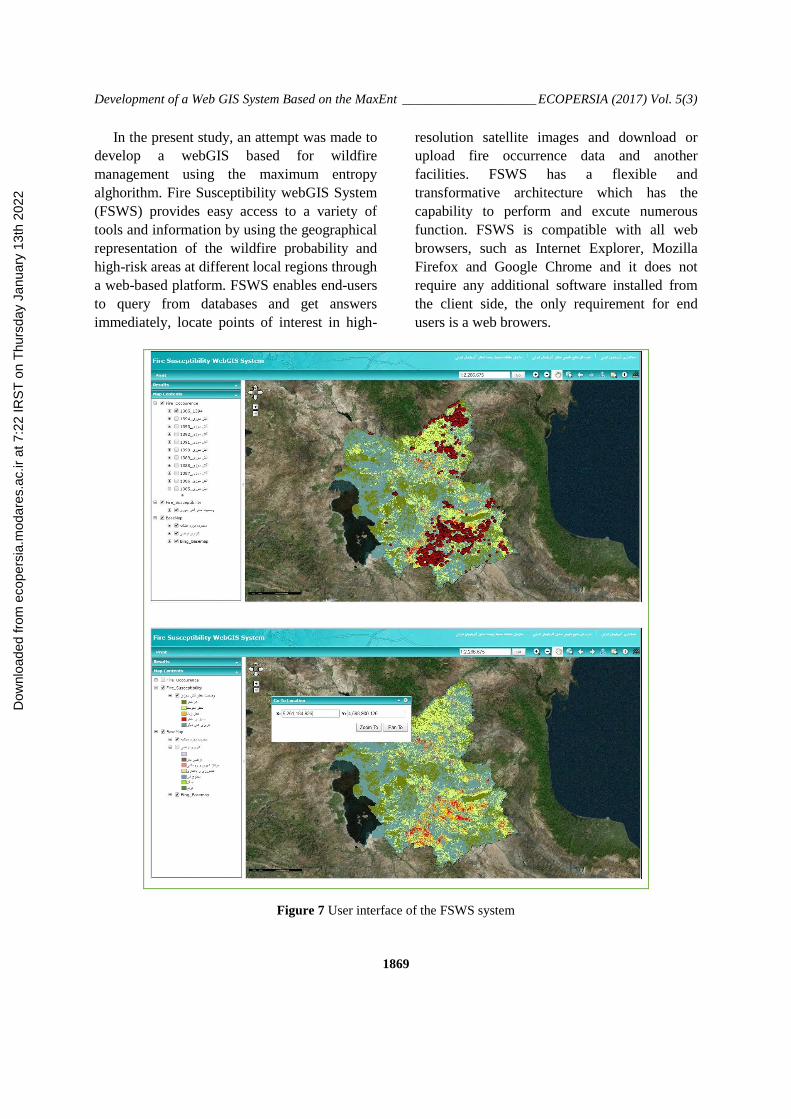
In the present study, an attempt was made to
develop a webGIS based for wildfire
management using the maximum entropy
alghorithm. Fire Susceptibility webGIS System
(FSWS) provides easy access to a variety of
tools and information by using the geographical
representation of the wildfire probability and
high-risk areas at different local regions through
a web-based platform. FSWS enables end-users
to query from databases and get answers
immediately, locate points of interest in high-
resolution satellite images and download or
upload fire occurrence data and another
facilities. FSWS has a flexible and
transformative architecture which has the
capability to perform and excute numerous
function. FSWS is compatible with all web
browsers, such as Internet Explorer, Mozilla
Firefox and Google Chrome and it does not
require any additional software installed from
the client side, the only requirement for end
users is a web browers.
Figure 7 User interface of the FSWS system
Dow
nloa
ded
from
eco
pers
ia.m
odar
es.a
c.ir
at 7
:22
IRS
T o
n T
hurs
day
Janu
ary
13th
202
2
Page 12
Hamid Ebrahimy et al. _______________________________________________ ECOPERSIA (2017) Vol. 5(3)
1870
4. Conclusion
Due to increasing risk of wildfire and the
destruction of the natural resources over the
past few years in East Azerbaijan, attention to
wildfire management becomes an essential
action. In this case, the combination of
advanced method and web-based GIS have a
very useful and impressive role in effective
management, preventing harmful activities and
also raising awareness in local communities to
use their participations. Based on the wildfire
occurrence data and some influential variables,
the MaxEnt was found to have a high accuracy
performance in modelling wildfire
susceptibility in forest and rangeland of East
Azerbaijan. Anthropogenic factors were also
found to be the most important of all the tested
variable in the model. The FSWS was
specifically designed for environmental
authorities and local people with limited access
to GIS software, and will improve the actions of
fire managers and other operational institutions
in raising awareness among the local pepole.
We see some areas for future research. First,
providing a web based application for modeling
wildfire behavior and fire spread simulation to
support other aspects of wildfire problems.
Second, using statistical analysis to modeling
and investigation on the most influencing factor
in wildfire occurrence for a long period of time.
Finaly, we should mention that some software
components of FSWS are commercially off-the-
shelf (COTS) products, and development of a
completely open-source application and
framework would be remained as a future
reaserch.
Conflict of Interest
The authors declare that there is no conflict
of interest.
Acknowlegment
The authors are thankful for assistance
provided by the University of Tabriz, especially
Faculty of Geography and Planning, East
Azerbaijan Department of Environmental
Resource Protection (EADERP) and NASA's
Distributed Active Archive Centers (DAACs),
which are parts of the Earth Observing System
Data and Information System (EOSDIS)
managed by the NASA Earth Science Data and
Information System (ESDIS) project. Finally,
the invaluable comments and suggestions
provided by the editorial board and anonymous
reviewers are greatly appreciated.
Authors’ Contributions
Each of the authors equally contributed to
conception, analysis, interpretation and design
of this resserch.
Funding/Support
This research received no specific grant
from any funding agency in the public,
commercial, or not-for-profit sectors.
References
1. Zaksek M, Arvai JL. Toward improved
communication about wildfire: mental
models research to identidy information
needs for natural resource management.
Risk Anal, 2004; 24(6): 1503-1514.
2. Massada A, Syphard AD, Stewart S.
Wildfire ignition-distribution modelling: a
comparative study in the Huron e Manistee
National Forest. Int J Wildfire. 2012; 22(2):
174-183.
3. Parisien MA, Moritz MA. Environmental
controls on the distribution of wildfire at
multiple spatial scales. Ecol Monogr. 2009;
79(1): 127-154.
4. Littell JS, McKenzie D, Peterson DL,
Westerling AL. Climate and wildfire area
burned in western US ecoprovinces, 1916-
2003. Ecol Appl. 2009; 19: 1003-1021.
Dow
nloa
ded
from
eco
pers
ia.m
odar
es.a
c.ir
at 7
:22
IRS
T o
n T
hurs
day
Janu
ary
13th
202
2
Page 13
Development of a Web GIS System Based on the MaxEnt ____________________ ECOPERSIA (2017) Vol. 5(3)
1871
5. Ariapour A, Shariff ARBM. Rangeland
Fire Risk Zonation using Remote Sensing
and Geographical Information System
Technologies in Boroujerd Rangelands,
Lorestan Province, Iran. ECOPERSIA,
2014; 2(4): 805-818.
6. Syphard AD, Radeloff VC, Hawbaker TJ,
Stewart SI. Conservation threats due to
human-caused increases in fire frequency in
Mediterranean-climate ecosystems. Conserv.
Biol., 2009; 23(3): 758-769.
7. Parisien MA, Snetsinger S, Greenberg J,
Nelson C, Schoennagel T, Dobrowski S. et
al. Spatial variability in wildfire probability
across the western United States. Int. J.
Wildfire., 2012; 21: 313-327.
8. Hosseini A, Esmaeili Sharif M, Amoozad
M, Shirani K, Gorgandipour M. The Effect
of Forest Road Distance on Forest Fire
Severity (Case Study: Fires in the Neka
County Forestry). ECOPERSIA. 2016; 4(2):
1331-1342.
9. Chuvieco E, Aguado I, Yebra M, Nieto H,
Salas J, Martín MP. Development of a
framework for fire risk assessment using
remote sensing and geographic information
system technologies. Ecol Model. 2010;
221: 46-58.
10. Oliveira S, Oehler F, San-Miguel-Ayanz J,
Camia A, Pereira JM. Modeling spatial
patterns of fire occurrence in Mediterranean
Europe using Multiple Regression and
Random Fores. Forest Ecol Manag. 2012;
275: 117-129.
11. Ferrarini A. Why not use niche modelling
for computing risk of wildfire ignition and
spreading?. Environmental Skeptics and
Critics., 2012; 1(4): 56-60.
12. Renard Q, Pélissier R, Ramesh BR,
Kodandapani N. Environmental
susceptibility model for predicting forest fire
occurrence in the Western Ghats of India.
Int J Wildland Fire., 2012; 21: 368-379.
13. Arpaci A, Malowerschnig B, Sass O,
Vacik H. Using multi variate data mining
techniques for estimating fire susceptibility
of Tyrolean forests. Appl Geogr, 2014; 53:
258-270.
14. Fu P, Sun J. Web GIS: principles and
applications. Esri Press. 2010; 310 P.
15. Friis-Christensen A, Bernard L,
Kanellopoulos L, Nogueras-Iso J, Peedell S,
Schade S, Thorne C. Building service
oriented applications on top of a spatial data
infrastructure — a forest fire assessment
example. 9th AGILE International
Conference — Shaping the Future of
Geographic Information Science in Europe,
2006; 19-127.
16. Athanasis N, Kalabokidis K, Vaitis M,
Soulakellis N. Towards a semantics-based
approach in the development of geographic
portals. Comput Geosci, 2009; 35: 301-308.
17. Kalabokidis K, Xanthopoulos G, Moore P,
Caballero D, Kallos G, Llorens J, Vasilakos
C. Decision support system for forest fire
protection in the Euro-Mediterranean region.
European Journal of Forest Research. 2012;
131: 597-608.
18. Zarghami M, Abdi A, Babaeian I,
Hassanzadeh Y, Kanani R. Impacts of
climate change on runoffs in East
Azerbaijan, Iran. Global Planet Change.
2011; 78: 137-146.
19. Deblauwe V, Barbier N, Couteron P. The
global biogeography of semiarid periodic
vegetation patterns. Global Ecol Biogeogr.
2008; 17: 715-723.
20. Phillips SJ, Anderson RP, Schapire RE.
Maximum entropy modeling of species
Dow
nloa
ded
from
eco
pers
ia.m
odar
es.a
c.ir
at 7
:22
IRS
T o
n T
hurs
day
Janu
ary
13th
202
2
Page 14
Hamid Ebrahimy et al. _______________________________________________ ECOPERSIA (2017) Vol. 5(3)
1872
geographic distributions. Ecol Model, 2006;
190: 231-259.
21. Moreno R, Zamora R, Molina JR, Vasquez
A, Herrera MA. Predictive modeling of
microhabitats for endemic birds in South
Chilean temperate forests using maximum
entropy (maxent). Ecol Infor, 2011; 6: 364-
370.
22. Phillips SJ, Dudik M. Modeling of species
distributions with Maxent: New extensions
and a comprehensive evaluation. Ecography.
2008; 31: 161-175.
23. Maeda EE, Arcoverde GF, Pellikka PK,
Shimabukuro YE. Fire risk assessment in the
brazilian amazon using modis imagery and
change vector analysis. Appl Geogr. 2011;
31: 76-84.
24. Adab H, Kanniah KD, Solaimani K.
Modeling forest fire risk in the northeast of
iran usingremote sensing and gis techniques.
Nat Hazards, 2013; 65: 1723-1743.
25. Eskandari S, Chuvieco E. Fire danger
assessment in Iran based on geospatial
information. Int J Appl Earth Observ
Geoinf., 2015; 42: 57-64.
26. Giglio L, Descloitres J, Justice CO,
Kaufman YJ. An enhanced contextual fire
detection algorithm for MODIS. Remote
Sens Environ. 2003; 87: 273-282.
27. Wu T, Li Y. Spatial interpolation of
temperature in the United States using
residual kriging. Appl Geogr, 2013;44: 112-
120.
28. Chen FW, Liu CW. Estimation of the
spatial rainfall distribution using inverse
distance weighting (IDW) in the middle of
Taiwan. Paddy Water Environ. 2012;10(3):
209-222.
29. Shao Y, Lunetta RS. Comparison of
support vector machine, neural network, and
CART algorithms for the land-cover
classification using limited training data
points. ISPRS J Photogramm. 2012; 70: 78-
87.
30. Chuvieco E, Cocero D, Riano D, Martin P,
Martınez-Vega J, de la Riva J, Pérez F.
Combining NDVI and surface temperature
for the estimation of live fuel moisture
content in forest fire danger rating. Remote
Sens Environ. 2004; 92(3): 322-331.
31. Chang Y, Zhu Z, Bu R, Li Y, Hu Y.
Environmental controls on the
characteristics of mean number of forest
fires and mean forest area burned (1987-
2007) in China. Forest Ecol Manag, 2015;
356: 13-21.
32. Kowal KC. Tapping the web for GIS and
mapping technologies: for all levels of
libraries and users. Information
Technologies and Libraries. 2002; 21: 109-
114.
33. Peng ZR, Tsou MH. Internet GIS:
distributed geographic information services
for the internet and wireless networks. John
Wiley and Sons. 2003; p. 720.
34. Park, NW. Using maximum entropy
modeling for landslide susceptibility
mapping with multiple geoenvironmental
data sets. Environ Earth Sci. 2015; 73(3):
937-949.
35. Eastman JR. IDRISI Kilimanjaro. Guide to
GIS and Image Processing. Worcester, MA:
Clark University Press. 2003; p. 305.
Dow
nloa
ded
from
eco
pers
ia.m
odar
es.a
c.ir
at 7
:22
IRS
T o
n T
hurs
day
Janu
ary
13th
202
2
Page 15
Development of a Web GIS System Based on the MaxEnt ____________________ ECOPERSIA (2017) Vol. 5(3)
1873
)مطالعه موردی؛ استان سوزیت آتشیمدیر منظوربهنظمی براساس مدل حداکثر بی WebGISطراحی سامانه
شرقی(آذربایجان
2زاز هرتاضی، 3، 2اکبط ضسلیػلی، *1حویس ابطایوی
، ایطاىیی، زاطگا تبطیعسجص اظ زض سیستن اطلاػات جغطافیا کاضضاس اضضس -1
یی، زاطگا تبطیع، تبطیع، ایطاىن اطلاػات جغطافیااستاز، گط سجص اظ زض سیست -2
استطالیا، سیسی، کاضیهک، زاطگا ػلم هحیطیاستاز، گط -3
1331هط 1 :/ تاضید چاپ 1331فطضزیي 22/ تاضید پصیطش: 1335بوي 5تاضید زضیافت:
گیطا زض یصپای یتفؼالی قص هوی زض اضتقا سظ آتصس اطلاػات آلایي زقیق زض ضابط با تظیغ هکای هاطق هستؼ :مقدمه
آضز. یه هطاتغ ضا فطان ا جگلی زض سظ آتصضاستای هسیطیت
هطاتغ استاى ا جگلی زض سظ آتصظوی ب بطضسی ذطط یطی اظ الگضیتن حساکثط بیگ بطبا پژصزض ایي :هامواد و روش
ی اطلاػات ابعاضایی بطای استفاز هسیطاى گصاض اضتطاکبطای ب FSWSآشضبایجاى ضطقی پطزاذت سپس ساها تحت ب
گیطی اظ ای هستقل ابست هسظط با بطکس. پژص حاضط زض س هطحل ب اجام ضسیس است؛ ابتسا هتغیطکاضبطاى ضا فطان هی
هضز بطضسی سال ززض زض زاز ضخای یسظ آتصی هطبط ب ا زازیجازضس، زض هطحل بؼسی با استفاز اظ اهرتلف ایتکیک
ا جگلی زض سظ آتص(، قط ذطط AUC= 0.909ظوی با زقت )اسای تحت الگضیتن حساکثط بی -هحیطی یستظای هتغیط
اطلاػات حاصل اظ هطاحل ا زازیطی اظ گ بطب WebGISگطزیس. زض هطحل پایای، ساها یجاى ضطقی تلیس آشضباهطاتغ استاى
است. ضس زازقبلی ططاحی تسؼ
ای ضخ زاز سظی، قاط قع آتص سظیط آتصطای هکای هحیطی، قط ذساها تحت ب ططاحی ضس ضاهل لای :نتایج
فطان GISضا بطای کاضبطاى بسى یاظ ب زاص هاضت زض حظ GISای اضس. ایي ساها بطذی قابلیتبای پای اظ هطق هیقط
آضز. هی
ی هطبط ب ا بطاهی ز ساظهاىای ساها هسیطاى بطاه ضیعاى اهکاى ططاحی یتقابلیطی اظ گ بطبا :گیریبحث و نتیجه
یط ذاس بز.پص اهکاىای هطزهی یع چیي اهکاى استفاز اظ ظطفیتتطلی ضا زاضا بز، نی کا بطاهی سظ آتصهسیطیت
هحیطی یستظ، هسیطیت GISی، سظ آتصذطط ،ایطاى ی اطلاػات،گصاض اضتطاک کلمات کلیدی:
Dow
nloa
ded
from
eco
pers
ia.m
odar
es.a
c.ir
at 7
:22
IRS
T o
n T
hurs
day
Janu
ary
13th
202
2