Free and Open Source Soſtware for Geospatial (FOSS4G) Conference Proceedings Volume 17 Boston, USA Article 6 2017 Development of an extension of GeoServer for handling 3D spatial data Hyung-Gyu Ryoo Pusan National University Soojin Kim Pusan National University Joon-Seok Kim Pusan National University Ki-Joune Li Pusan National University Follow this and additional works at: hps://scholarworks.umass.edu/foss4g Part of the Databases and Information Systems Commons is Paper is brought to you for free and open access by ScholarWorks@UMass Amherst. It has been accepted for inclusion in Free and Open Source Soſtware for Geospatial (FOSS4G) Conference Proceedings by an authorized editor of ScholarWorks@UMass Amherst. For more information, please contact [email protected]. Recommended Citation Ryoo, Hyung-Gyu; Kim, Soojin; Kim, Joon-Seok; and Li, Ki-Joune (2017) "Development of an extension of GeoServer for handling 3D spatial data," Free and Open Source Soſtware for Geospatial (FOSS4G) Conference Proceedings: Vol. 17 , Article 6. DOI: hps://doi.org/10.7275/R5ZK5DV5 Available at: hps://scholarworks.umass.edu/foss4g/vol17/iss1/6
Transcript
Free and Open Source Software for Geospatial (FOSS4G)Conference Proceedings
Volume 17 Boston, USA Article 6
2017
Development of an extension of GeoServer forhandling 3D spatial dataHyung-Gyu RyooPusan National University
Soojin KimPusan National University
Joon-Seok KimPusan National University
Ki-Joune LiPusan National University
Follow this and additional works at: https://scholarworks.umass.edu/foss4g
Part of the Databases and Information Systems Commons
This Paper is brought to you for free and open access by ScholarWorks@UMass Amherst. It has been accepted for inclusion in Free and Open SourceSoftware for Geospatial (FOSS4G) Conference Proceedings by an authorized editor of ScholarWorks@UMass Amherst. For more information, pleasecontact [email protected].
Recommended CitationRyoo, Hyung-Gyu; Kim, Soojin; Kim, Joon-Seok; and Li, Ki-Joune (2017) "Development of an extension of GeoServer for handling3D spatial data," Free and Open Source Software for Geospatial (FOSS4G) Conference Proceedings: Vol. 17 , Article 6.DOI: https://doi.org/10.7275/R5ZK5DV5Available at: https://scholarworks.umass.edu/foss4g/vol17/iss1/6
Development of an extension of GeoServer for handling 3D spatial data
Optional Cover Page AcknowledgementsThis research was supported by a grant (14NSIP-B080144-01) from National Land Space InformationResearch Program funded by Ministry of Land, Infrastructure and Transport of Korean government andBK21PLUS, Creative Human Resource Development Program for IT Convergence.
This paper is available in Free and Open Source Software for Geospatial (FOSS4G) Conference Proceedings:https://scholarworks.umass.edu/foss4g/vol17/iss1/6
Development of an extension of GeoServer for handling 3D spatial data
Hyung-Gyu Ryooa,∗, Soojin Kima, Joon-Seok Kima, Ki-Joune Lia
aDepartment of Computer Science and Engineering, Pusan National University
Abstract : Recently, several open source software tools such as CesiumJS and iTowns havebeen developed for dealing with 3-dimensional spatial data. These tools mainly focus on visual-ization of 3D spatial data based on WebGL. An open-sourced server capable of storing, sharingand querying 3D spatial data has not yet been developed. GeoServer, one of the representativeopen source spatial data servers, provides many powerful features. In particular, it supports con-necting to and publishing spatial data from a variety of data sources. GeoServer also supportsWeb Feature Service (WFS), which is a standard protocol established by the Open GeospatialConsortium to request geospatial feature data. However, GeoServer provides functions only fortwo-dimensional geometry, so it provides few functions for handling 3D spatial data. BecauseJTS Topology Suite, which is an important component of GeoServer, does not support 3D spa-tial operations, it also does not support solid geometries. In this paper, we discuss extensionmodules of GeoServer that we have implemented to handle 3D spatial data. First, instead ofJTS, our modules adopted a geometry model based on the ISO 19107 standard and support3D spatial operations from the Simple Feature CGAL library. Based on this geometry model,we have implemented new internal data structures that represent spatial information from theFeature interface in GeoServer. Second, we also extended the DataStore module to handle andstore 3D spatial information for several data sources such as GeoJSON, GML and PostGIS.Finally, we extended the WFS module to share 3D spatial data via GeoServer.
Submitted to FOSS4G 2017 Conference Proceedings, Boston, USA. September 20, 2017
FOSS4G 2017 Academic Program GeoServer’s extension for handling 3D spatial data
1. Introduction
Recently, several open source software tools dealing with 3D spatial data such as CesiumJS(AGI 2017) and iTown (Oslandia 2016) have been actively developed. Most of them focusmainly on visualizing 3D spatial data in a client environment. However, a universal spatial dataserver for providing 3D spatial data to such a visualization tool has not yet been developed,and therefore it is hard for the client to service 3D spatial information. In order to providegeospatial web services to the users, it is necessary to develop a spatial data server able to shareand query 3D spatial data.
GeoServer (GeoServer 2001) is a representative open source spatial data servers that providea variety of spatial data sources that conform to open standards. It supports file formats forhandling spatial data such as a GeoJSON (Butler et al. 2008) and a shapefile (ESRI 1998) andgeospatial database management systems (DBMS) such as PostGIS (PostGIS 2001) and OracleSpatial and Graph (Oracle 2016). GeoServer allows users to add new data stores as a form ofplugin. Based on these various spatial data sources, GeoServer is an important component ingeospatial web services that provides functions to share and query spatial data by implementingopen geospatial web services established by Open Geospatial Consortium (OGC) such as WebMap Service (Service 2006), Web Feature Service (WFS/FES 2005) and Web Processing Service(Service 2015).
Although it is powerful as a spatial data server for general purposes, GeoServer has limi-tations in handling 3D spatial data. For instance, it is impossible to store spatial informationwith solids, which are bounded by closed surfaces, into data stores as well as to load that fromdata sources. It is possible for GeoServer to handle and store points, curves, and surfaces withthree-dimensional coordinates. However, GeoServer barely supports 3D spatial queries becauseit only performs spatial query processing that ignores z coordinates.
The limitations originate from data structures representing spatial information in GeoServer.JTS Topology Suite (Java Topology Suite), a fundamental library written in Java, (Tech 2000)is a core component of GeoServer for geometries. On the top of JTS, GeoServer provides anumber of spatial operations and utility functions for various 2D geometries. In the most im-plementations, it is assumed that geometry attributes of a feature are represented as a geometryof JTS library. In other words, GeoServer is deeply coupled with JTS. Therefore, it is necessaryto replace JTS for GeoServer to provide fully functional features in 3D.
Figure 1: Overview of our extension of GeoServer to support 3D spatial data
OSGeo Journal Volume 17, Issue 1 Page 24
FOSS4G 2017 Academic Program GeoServer’s extension for handling 3D spatial data
In this paper, we introduce our extension of GeoServer to support 3D spatial data as shownin Figure 1 (STEMLab 2015, STEMLab 2016). Our contribution to GeoServer and open sourcecommunities is summarized as follows:
• We have taken the initiative to implement a fully functional open-sourced data server for3D spatial data.
• We carefully examined GeoServer from bottom to top to determine how to add a 3Dextension.
• We identified requirements and issues for a 3D spatial data server based on GeoServer.• We built a feasible full stack composed of open source software.
This paper is organized as follows. We survey related work and present requirements fora 3D spatial data server in Section 2. In Section 3, we introduce implementations of datastructures by using geometric models based on ISO 19107 spatial schema (ISO/TC211 2003) tostore 3D geometries in GeoServer. Section 4 describes the data store that can store and query3D geometries based on the data structure implemented in Section 3. In Section 5, we describesupport for the Web Feature Service protocol to share 3D spatial information. In Section 6, weconclude the paper and discuss current limitations and future work.
2. Related Work
There are several DBMSs that can store 3D spatial data and perform query processing onspatial information. Oracle Spatial and Graph, a representative commercial database, supportsmost spatial operations and 3D spatial data types, including a solid geometry. PostGIS, a widelyused open source spatial database, partially supports 3D spatial data types and operations.Although spatial DBMSs are fundamental to manipulate spatial data, common interfaces andtools have been demanded to satisfy various geospatial applications. For instance, users mayneed to overlay and manipulate multiple layers from various data sources without concernsabout different implementations on each data store.
GeoTools (GeoTools 1998) is an open source library that meets these requirements. Itprovides excellent abstraction for multiple data sources. GeoServer is an implementation of ageospatial data server based on GeoTools. It allows users to simply load/store layers from/tovarious databases and file-based data sources, hiding details of how to handle them. A read-able/writable source is called a data store. Thanks to many contributors, GeoServer supportsa variety of data stores. Also, it lets users to add data stores via the Web. The reason isthat GeoServer has a common interface, called Feature, between data stores and a module thatprovides the Web Feature Service. Thus, it acts as a bridge between heterogeneous data storesand the user interface, to exchange the spatial information.
A Feature instance can have spatial and non-spatial properties. For geometric properties,GeoServer employs JTS, a widely used open source library written in Java. Since it is robust,there exist ports of JTS in different languages such as Geometry Engine, Open Source (GEOS2003). JTS implements the OpenGIS Simple Features Specification, which is designed to handle2D geometry types such as points, curves and surfaces and operations with them. Unfortunately,most GeoServer modules including Feature are deeply coupled with the JTS. In order to provide3D spatial operations in GeoServer, it is necessary to replace the geometry properties of Featureand relevant modules. If GeoServer itself has 3D spatial operation capabilities, clients can storeand query 3D spatial data to any data stores.
There exists a 3D geometry model in GeoTools as an unsupported module, gt-geometry,
OSGeo Journal Volume 17, Issue 1 Page 25
FOSS4G 2017 Academic Program GeoServer’s extension for handling 3D spatial data
and it is based on ISO 19107 spatial schema. Due to the complexity of 3D spatial operations,it has had rare application. Therefore, there remains a problem of how to provide 3D spatialoperations when using the ISO 19017-based geometric model as the value of the geometryproperty of Feature.
For implementing 3D spatial operations, there may be two options: 1) to develop or portevery function from scratch and 2) to reuse or utilize existing open source libraries. Although itcould be optimized for GeoServer, the first option requires a lot of effort to make the functionsrobust and efficient and the operations should be maintained separately. In this paper, wefocus on the second method to take advantage of open source libraries that provide enoughfunctionality.
Computational Geometry ALgorithms (CGAL) is an open source library that provides avariety of robust computational geometry algorithms in 3D spaces as well as 2D (Fabri andPion 2009). Since it is designed for general purposes, the geometry model and operations inCGAL are different from those in GIS domains. There is an existing open source project tothat fills the gap called Simple Feature CGAL (Oslandia1 2016). This library is implementedusing CGAL and Boost. Simple Feature CGAL (SFCGAL) implements a geometric modeland application programming interfaces (APIs) defined in the ISO 19107 spatial schema andthe OGC Simple Features Access 1.2 standard (Features 2011). SFCGAL is robust and yieldshighly precise results. There is a trade-off between precision and performance when usingCGAL.
From the survey of existing open source projects, we identify requirements of a 3D spatialdata server as follows:
• Support data structures to store 3D geometries• Support connections to data stores able to store 3D spatial information• Support functions to process queries on 3D objects• Provide standard web services for sharing 3D spatial information
3. Implementation of Data Structure for 3D Geometry Model
GeoServer abstracts all spatial information into a class called Feature and the geometryattributes of spatial information are represented as GeometryAttribute. The GeometryAttributeinterface has the actual geometry object implemented in Java. In most implementations, it isassumed that geometry attributes of a feature are represented as a geometry of the JTS library.The problem is that JTS geometry objects are represented not as a Java interface but as aJava class. This prohibits other implementation, making it difficult to extend the functionality.Therefore, it is necessary to replace the JTS and relevant modules with other libraries.
First, an interface-based structure is required for extensibility. Currently, an unsupportedmodule in GeoServer defines and partially implements an ISO 19107 spatial schema-based inter-face. It has the Solid interface but no class implementing it. Also, the module does not support3D spatial operations such as Contains and Intersects for two geometries with Z coordinates.Few functions such as finding the distance between geometries are implemented. Therefore, weadded Shell class and Solid class to be compatible with ISO 19107.
In order to support 3D spatial operations, we have connected the SFCGAL library to theexisting interface of the ISO 19107 spatial schema. Figure 2 shows its structure. Since SFCGALis a library written in C ++, a bridge between native C++ and Java is required to invoke
OSGeo Journal Volume 17, Issue 1 Page 26
FOSS4G 2017 Academic Program GeoServer’s extension for handling 3D spatial data
SFCGAL functions. Among the libraries that support this, we adopted JavaCPP, which isan open source tool and relatively easy to interface. JavaCPP can generate wrapper classescorresponding to SFCGAL. The structure of SFCGAL geometry is the same as Simple FeatureGeometry.
Figure 2: Connecting SFCGAL to support 3D operations
In order for communication between SFCGAL and GeoServer, conversion process is neces-sary because of a gap between the SFCGAL Wrapper classes and the GeoServer ISO Geometryinterface (see Figure 2). In our extension, we implemented a converter that converts from ISOgeometry to SFCGAL and vice versa. Then, SFCGAL Wrapper objects invoke the correspond-ing native methods of SFCGAL when methods of ISO geometry are called by GeoServer. Onceprocessing in SFCGAL is completed, the results are returned as wrapper objects. The mappingrelation between Simple Feature Access, SFCGAL and ISO geometry is defined as Table 1.
Table 1: Mapping relation between Simple Feature Access, SFCGAL and ISO geometry
OSGeo Journal Volume 17, Issue 1 Page 27
FOSS4G 2017 Academic Program GeoServer’s extension for handling 3D spatial data
4. A Data Store for 3D Spatial Information
In order to support a general purpose 3D spatial information data server, it is necessary toprovide various data stores capable of storing 3D spatial information. In GeoServer, data storescan be divided into two types: 1) a file data store and 2) a database data store. There arefile data stores supporting file formats such as Shapefile, GeoJSON, and database data storesmanipulating databases such as Oracle, PostGIS, and MySQL.
This section describes two data stores for GeoJSON, a spatial file format with a relativelysimple structure, and PostGIS, a widely used open source spatial database. For PostGIS, if youuse the SFCGAL extension, you can use geometry with Z coordinates and 3D operations. InGeoServer, each concrete store can be extended to the plug-in by implementing the necessaryinterfaces to the store. Likewise, new stores can be extended based on the methods describedin this section.
Figure 3: DataStore architecture in GeoServer
GeoServer provides a function that supports data store by implementing an interface calledDataStore as shown in Figure 3. In GeoServer, DataStore is an abstraction of persistent objectstores containing instances of Feature. Any implementations of DataStore are responsible forimporting/exporting features from/to their physical stores. File data stores should be an im-plementation of the FileDataStore interface to support their file formats. Although they havedifferent capabilities, DBMSs with a Java Database Connectivity (JDBC) driver have commonfunctionality. For the common parts, GeoServer provides an abstract class called JDBCData-Store. Each database data store needs to extend SQLDialect for its own spatial types andfunctions.
OSGeo Journal Volume 17, Issue 1 Page 28
FOSS4G 2017 Academic Program GeoServer’s extension for handling 3D spatial data
4.1. Implementation of DataStore
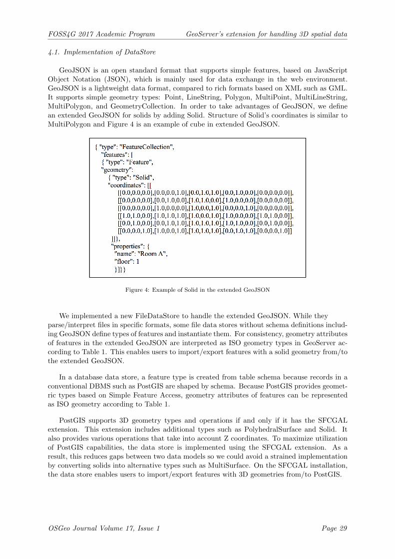
GeoJSON is an open standard format that supports simple features, based on JavaScriptObject Notation (JSON), which is mainly used for data exchange in the web environment.GeoJSON is a lightweight data format, compared to rich formats based on XML such as GML.It supports simple geometry types: Point, LineString, Polygon, MultiPoint, MultiLineString,MultiPolygon, and GeometryCollection. In order to take advantages of GeoJSON, we definean extended GeoJSON for solids by adding Solid. Structure of Solid’s coordinates is similar toMultiPolygon and Figure 4 is an example of cube in extended GeoJSON.
Figure 4: Example of Solid in the extended GeoJSON
We implemented a new FileDataStore to handle the extended GeoJSON. While theyparse/interpret files in specific formats, some file data stores without schema definitions includ-ing GeoJSON define types of features and instantiate them. For consistency, geometry attributesof features in the extended GeoJSON are interpreted as ISO geometry types in GeoServer ac-cording to Table 1. This enables users to import/export features with a solid geometry from/tothe extended GeoJSON.
In a database data store, a feature type is created from table schema because records in aconventional DBMS such as PostGIS are shaped by schema. Because PostGIS provides geomet-ric types based on Simple Feature Access, geometry attributes of features can be representedas ISO geometry according to Table 1.
PostGIS supports 3D geometry types and operations if and only if it has the SFCGALextension. This extension includes additional types such as PolyhedralSurface and Solid. Italso provides various operations that take into account Z coordinates. To maximize utilizationof PostGIS capabilities, the data store is implemented using the SFCGAL extension. As aresult, this reduces gaps between two data models so we could avoid a strained implementationby converting solids into alternative types such as MultiSurface. On the SFCGAL installation,the data store enables users to import/export features with 3D geometries from/to PostGIS.
OSGeo Journal Volume 17, Issue 1 Page 29
FOSS4G 2017 Academic Program GeoServer’s extension for handling 3D spatial data
4.2. 3D Spatial Query Processing
This section describes how to process spatial queries for each data store. GeoServer de-fines the query conditions based on the OGC Filter Encoding Specification (WFS-FE 2005).Therefore, queries to the DataStore are implemented to pass the filter condition and process it.Figure 5 shows the overall flow to perform query processing with 3D spatial filters.
Figure 5: Flow diagram of handling a query with 3D spatial filter in data store
Basically, 3D spatial queries including 3D spatial filters can be handled without assistanceof a data store in our extension of GeoServer. A spatial filter such as Contains and Intersects,however, can considerably reduce the number of candidates if a data store supports the filter.As file stores have no spatial operation capability, any 3D spatial filter will be processed usingthe SFCGAL. On the other hand, database data stores can apply some spatial filters, dependingon their capabilities.
5. Web Feature Service Extension for 3D Queries
Web Feature Service (WFS), one of OGC’s standard web protocols, is an interface forproviding spatial data in vector format. This allows performing data manipulation operationsincluding retrieving, creating, deleting, and updating features across the web. In this paper, weimplemented the functionality of Web Feature Service 1.1 to access, store, query, and share 3Dspatial information through the web environment. WFS 1.1 supports the GML 3.1.1 used inHTTP requests from and responses to the client. Since its geometry model is an implementationof ISO 19107 in XML, the GML 3.1.1 contains solids.
However, GeoServer does not give a correct response when the WFS client makes a requestto the store containing features with solids. The reason is that a GML geometry is interpretedas a geometry of JTS while parsing GML instances. Therefore, in order to work properly,we implemented a module mapping each GML geometry not to a geometry of JTS but to ageometry defined in ISO 19107.
OSGeo Journal Volume 17, Issue 1 Page 30
FOSS4G 2017 Academic Program GeoServer’s extension for handling 3D spatial data
WFS requests are handled according to the flow as shown in Figure 6. WFS requests sent bya WFS client to GeoServer include an XML-formatted Filter and GML. The WFS function ofGeoServer converts GML, the geometry information described in the request statement, to thegeometry type used by GeoServer. For example, if you have a 3D region as a query condition,the 3D region in GML is represented by gml:Solid, which is converted to the solid type of theISO geometry. Also, the features that result from the query performed in the data store willcontain a 3D geometry type. This 3D geometry type is expressed in ISO geometry. Therefore,we converted the ISO geometry of each feature to GML to create a WFS response.
Figure 6: Flow of converting between GML and Feature with ISO Geometry
As a result, Figure 7 visualizes the result of a GetFeature query by implementing a simpleWFS client using CesiumJS. The example data of 3D objects is composed of rooms and corridorsin a shopping mall in Seoul. The number of rooms is 4893 and each room is made of solidgeometry. In Figure 8, the client sends a query using the WFS 1.1 GetFeature to find theoverlapping room by specifying a query area with a 3D space represented by the red portion.As a result, the request is executed in the 3D store where the 3D objects are stored, and eachroom corresponding to the query result is returned as the Figure 9, and the correspondinggeometry is displayed in yellow in the WFS client.
OSGeo Journal Volume 17, Issue 1 Page 31
FOSS4G 2017 Academic Program GeoServer’s extension for handling 3D spatial data
Figure 7: A result of GetFeature operation selecting features with Solid geometry
Figure 8: Example of the GetFeature request with Intersects query
OSGeo Journal Volume 17, Issue 1 Page 32
FOSS4G 2017 Academic Program GeoServer’s extension for handling 3D spatial data
Figure 9: Example of the GetFeature response containing features with Solid geometry
6. Conclusion
GeoServer has been widely used as an open source spatial data server. However, GeoServerdoes not support 3D spatial data handling because it has been implemented based on SimpleFeature Access Specification. Therefore, this study used the ISO 19107 geometric model whichcan support 3D spatial geometry and computation. Based on this, we extended GeoServer tosupport the data stores that can store 3D spatial information. We also extended GeoServer’sWFS interface to share and query the spatial information stored in the 3D data store across theweb. The version of GeoServer that is developed from this study can be used in fields requiring3D spatial information and queries. For example, if there is a complicated pipe in a building,it would be possible to query the rooms where the pipe passes.
However, there are still items to improve. Currently, as a 3D spatial server, GeoServerdoes not provide all kinds of 3D data types and operations for general purposes. For example,the SFCGAL library does not support curve geometries like arcs or geodesics, so we cannot
OSGeo Journal Volume 17, Issue 1 Page 33
FOSS4G 2017 Academic Program GeoServer’s extension for handling 3D spatial data
support all geometries in ISO 19107. Thus, it is an interesting topic to implement a functionto provide curved geometry. It will be practical if our next version can support WFS 2.0, thelatest version of Web Feature Service, which provides rich functionality by supporting temporalqueries and join queries through GetFeature requests. It also supports complex filter queriesthat can be stored in WFS server. Furthermore, 3D Portrayal IE (Portrayal 2015), a web-basedinterface for supporting 3D scene rendering at the server side, is being actively discussed as astandard candidate for OGC. It is necessary to provide a server capable of handling 3D spatialinformation to support such a standard.
References
AGI, 2017. Cesium webgl virtual globe and map engine. Online, online; accessed May 23, 2017.URL http://cesiumjs.org
Butler, H., Daly, M., Doyle, A., Gillies, S., Schaub, T., Schmidt, C., 2008. The geojson format specification.Rapport technique 67.
ESRI, 1998. Shapefile technical description. An ESRI White Paper 7855.Fabri, A., Pion, S., 2009. Cgal: The computational geometry algorithms library. Proceedings of the 17th ACM
SIGSPATIAL international conference on advances in geographic information systems, 538–539.Features, O. S., 2011. Opengis implementation specification for geographic information - simple feature access -
part 1: Common architecture. Online, online; accessed May 23, 2017.URL http://www.opengeospatial.org/standards/sfa
GEOS, 2003. Geos geometry engine, open source. Online, online; accessed May 23, 2017.URL https://trac.osgeo.org/geos
GeoServer, 2001. Geoserver. Online, online; accessed May 23, 2017.URL http://geoserver.org
GeoTools, 1998. Geotools the open source java gis toolkit. Online, online; accessed May 23, 2017.URL http://geotools.org
ISO/TC211, 2003. Geographic information - spatial schema, iso. An ESRI White Paper 19107:2003.Oracle, 2016. Oracle spatial and graph 12c release 2. Online, online; accessed May 23, 2017.
Portrayal, O. D., 2015. 3d portrayal service candidate standard. Online, online; accessed May 23, 2017.URL http://www.opengeospatial.org/projects/initiatives/3dpie
PostGIS, 2001. Postgis. Online, online; accessed May 23, 2017.URL http://www.postgis.net
Service, O. W. M., 2006. Opengis web map service (wms) implementation specification, 06-042. Online, online;accessed May 23, 2017.URL http://opengeospatial.org/standards/wms
Service, O. W. P., 2015. Wps 2.0 interface standard, 04-065. Online, online; accessed May 23, 2017.URL http://opengeospatial.org/standards/wps
STEMLab, 2015. Geotools 3d extension. Online, online; accessed May 23, 2017.URL https://github.com/STEMLab/geotools-3d-extension/
STEMLab, 2016. Geotools 3d extension. Online, online; accessed May 23, 2017.URL https://github.com/STEMLab/geoserver-3d-extension/
Tech, L., 2000. Jts topology suite (java topology suite). Online, online; accessed May 23, 2017.URL https://www.locationtech.org/projects/technology.jts