Development of high spatial resolution Forest Fire Index for boreal conditions Applications to Helsinki Testbed area - Preliminary results- Andrea Vajda, FMI Mesoscale Atmospheric Network Course, February 13, 2007
Transcript
Development of high spatial resolution Forest Fire Index for boreal conditions
Applications to Helsinki Testbed area
- Preliminary results-
Andrea Vajda, FMI
Mesoscale Atmospheric Network Course, February 13, 2007
Ferbuary 13, 2007Mesoscale Atmospheric Network Course, HY
Outline
The Finnish Forest Fire Index calculation
Objectives
Helsinki Testbed applications
- Downscaling soil moisture data
- Spatial variation of temperature and precipitation
- Adjustment of the rainfall gauges and weather radar precipitation data
Next steps
Ferbuary 13, 2007Mesoscale Atmospheric Network Course, HY
Soil surface moisture as the indicator of the fire risk
Potential evaporation on a 10 km * 10 km grid
Penman-Monteith equation
The forest fire index calculation in Finland
Ferbuary 13, 2007Mesoscale Atmospheric Network Course, HY
Soil surface moisture as the indicator of the fire risk
Surface layer
Precipitation Evaporation
Infiltration and run-off
The drying/wetting of soil surface due to evaporation/precipitation is based
on results obtained from field measurements
Estimates of soil moisture content
Forest fire index
FFI ≥4 → Forest fire warning
The forest fire index calculation in Finland (cont’d)
Ferbuary 13, 2007Mesoscale Atmospheric Network Course, HY
Spatial analysis of fire index 08.05.2006 at 9.00 a.m.
Provincial (weighted) averages08.05.2006 at 9.00 a.m.
warningno warning
Reference: http://virpo.fmi.fi/metsapalo/
[-24h] [-12h] [0h] [+12h] [+24h]
Click to get past or forecast situation!
Forest fire risk assessment for Finland
Ferbuary 13, 2007Mesoscale Atmospheric Network Course, HY
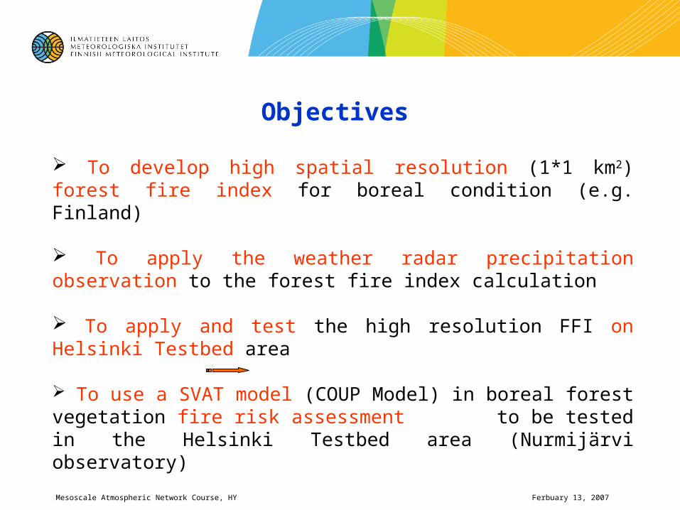
Objectives
To develop high spatial resolution (1*1 km2) forest fire index for boreal condition (e.g. Finland)
To apply the weather radar precipitation observation to the forest fire index calculation
To apply and test the high resolution FFI on Helsinki Testbed area
To use a SVAT model (COUP Model) in boreal forest vegetation fire risk assessment to be tested in the Helsinki Testbed area (Nurmijärvi observatory)
Ferbuary 13, 2007Mesoscale Atmospheric Network Course, HY
High resolution FFI development- Helsinki Testbed Application
Spatial variation of soil moisture on August 4, 2006
200 km
250 km
10 km*10 km 1 km*1 km
Ferbuary 13, 2007Mesoscale Atmospheric Network Course, HY
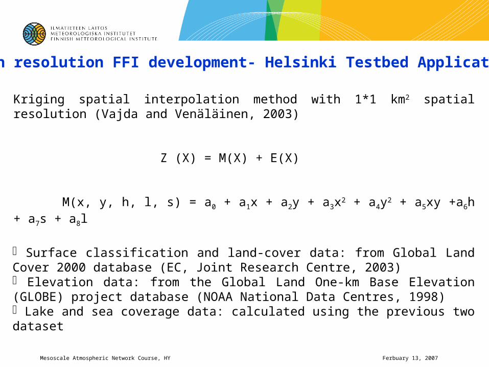
High resolution FFI development- Helsinki Testbed Application
Kriging spatial interpolation method with 1*1 km2 spatial resolution (Vajda and Venäläinen, 2003)
Surface classification and land-cover data: from Global Land Cover 2000 database (EC, Joint Research Centre, 2003) Elevation data: from the Global Land One-km Base Elevation (GLOBE) project database (NOAA National Data Centres, 1998) Lake and sea coverage data: calculated using the previous two dataset
Ferbuary 13, 2007Mesoscale Atmospheric Network Course, HY
Spatial variation of air temperature measured at 12 h on 3-4 August, 2006
Input data: from 106 stations
Spatial resolution: 1*1 km2
200 km
250 km
Ferbuary 13, 2007Mesoscale Atmospheric Network Course, HY
Spatial variation of precipitation based on gauge measurements on August 3, 2006
1*1 km2
Input data: daily rainfall sum from 99 gauges
Ferbuary 13, 2007Mesoscale Atmospheric Network Course, HY
Application of weather radar precipitation data to fire risk calculation
Rain measurements
- Circles: Radar 20-60km
- Dots: Manual observations
- Big diamonds: FD12P
- Small diamonds: Potential FD12P
- Triangles: Automatic snow depth
- Squares: Weighing gauge
Ferbuary 13, 2007Mesoscale Atmospheric Network Course, HY
Spatial variation of precipitation based on radar observation on August 3, 2006
1*1 km2
r= 0.38
Ferbuary 13, 2007Mesoscale Atmospheric Network Course, HY
The trend and the fluctuation of the spatial variation of precipitation obtained by the combination of
gauge and radar data
M (X) Z(X)
Ferbuary 13, 2007Mesoscale Atmospheric Network Course, HY
Rainfall data obtained from gauge-radar adjustment
Ferbuary 13, 2007Mesoscale Atmospheric Network Course, HY
Work to be done
To test/verify the adjustment method and analyze the results using a longer time period
To demonstrate the influence of high spatial resolution precipitation information on the variation of fire risk indices
To apply the high resolution FFI to Helsinki Testbed area Finland
Explore SVAT methods to estimate vegetation fire risk