DEVELOPMENT OF SOCIO-TECHNICAL APPROACH FOR LANDSLIDE MITIGATION AND RISK REDUCTION PROGRAM IN INDONESIA Dwikorita Karnawati 1 , Syamsul Maarif 2 , Teuku Faisal Fathani 3 , and Wahyu Wilopo 4 1,3,4 Faculty of Engineering, Universitas Gadjah Mada, Yogyakarta, Indonesia 1 e-mail: [email protected], [email protected]3 e-mail: [email protected]2 National Agency for Disaster Management, Jakarta Pusat, Indonesia Received Date: October 26, 2012 Abstract Intensive efforts for mitigating and reducing the risk of landslides in Indonesia have been conducted since more than 30 years ago. But still, substantial socio-economical losses continuously occur as the results of landslide disasters. Admittedly, the natural conditions plays important role in controlling the susceptibility and triggering the occurrence of landslides. Yet, the human interfere and landuse changing crucially contribute in the triggering process of landslides. Indeed, the increase in societal impacts due to the landslide disasters also strongly related to the landuse changing, driven by the social constrains. Unfortunately, the technical solution for landslide mitigation and risk reduction does not always appropriately address the socio cultural and socio economical aspects of the disaster prone area. That is why, the hybrid socio-technical system is promoted in this study, in which not only the engineering but also social system has to be strongly considered in the mitigation and risk reduction efforts. The proposed technical system was mainly supported by the participatory landslide hazard and risk map as well as the community-based landslide early warning system. Such system was developed by enhancing the local knowledge, through the local participation, and utilizing the local materials. Meanwhile, the social system was established through a series of community empowerment programs and supported by the establishment of local task force for disaster risk reduction at the village. Accordingly, the developed system can be effectively operated, maintained and sustained by the local community. Indeed, the roles of the local task force and the local university are very important to drive and ensure the effectiveness of the landslide mitigation and disaster risk reduction. Keywords: Community empowerment, Hybrid socio-technical system, Local knowledge, Local participation Introduction Situated in such a dynamic geological region, which is occupied by the high density of population, Indonesia is frequently struck by various types of geological disasters, which lead to substantial death tolls, casualties and socio-economical losses. In fact, 6,632 events of natural disasters (mainly geological disasters) have been recorded within the period of 1997 to 2009, and those disasters resulted in the total death tolls of 151,277 people [1]. Invited Paper ASEAN Engineering Journal Part C, Vol 2 No 1 (2013), ISSN 2286-8151 p.22
Transcript
DEVELOPMENT OF SOCIO-TECHNICALAPPROACH FOR LANDSLIDE MITIGATION
3 e-mail: [email protected] National Agency for Disaster Management, Jakarta Pusat, Indonesia
Received Date: October 26, 2012
Abstract
Intensive efforts for mitigating and reducing the risk of landslides in Indonesia have been conducted since more than 30 years ago. But still, substantial socio-economical losses continuously occur as the results of landslide disasters. Admittedly, the natural conditions plays important role in controlling the susceptibility and triggering the occurrence of landslides. Yet, the human interfere and landuse changing crucially contribute in the triggering process of landslides. Indeed, the increase in societal impacts due to the landslide disasters also strongly related to the landuse changing, driven by the social constrains. Unfortunately, the technical solution for landslide mitigation and risk reduction does not always appropriately address the socio cultural and socio economical aspects of the disaster prone area. That is why, the hybrid socio-technical system is promoted in this study, in which not only the engineering but also social system has to be strongly considered in the mitigation and risk reduction efforts. The proposed technical system was mainly supported by the participatory landslide hazard and risk map as well as the community-based landslide early warning system. Such system was developed by enhancing the local knowledge, through the local participation, and utilizing the local materials. Meanwhile, the social system was established through a series of community empowerment programs and supported by the establishment of local task force for disaster risk reduction at the village. Accordingly, the developed system can be effectively operated, maintained and sustained by the local community. Indeed, the roles of the local task force and the local university are very important to drive and ensure the effectiveness of the landslide mitigation and disaster risk reduction.
Keywords: Community empowerment, Hybrid socio-technical system, Local knowledge, Local participation
Introduction
Situated in such a dynamic geological region, which is occupied by the high density of population, Indonesia is frequently struck by various types of geological disasters, which lead to substantial death tolls, casualties and socio-economical losses. In fact, 6,632 events of natural disasters (mainly geological disasters) have been recorded within the period of 1997 to 2009, and those disasters resulted in the total death tolls of 151,277 people [1].
Invited Paper
ASEAN Engineering Journal Part C, Vol 2 No 1 (2013), ISSN 2286-8151 p.22
In terms of the average frequency of disaster events, landslide has been considered as the top-five rank of most frequent disasters in Indonesia with the average events of 92 per year, after floods (297 events per year), droughts (156 events per year), fires (147 events per year) and typhoons (110 events/ year). In fact, 603 events of landslide disasters were recorded from the year of 2002 – 2009 with the fatalities of 110 people, in which the 225 events occurred in 2009 with the death tolls of 76 people [2]. Moreover, 2232 disaster events were recorded in 2010, in which 70% of those events due to the hydro-meteorological disasters, including floods, debris flood, landslides, droughts and typhoon [3]. Again, in 2011 the recorded total events of disasters were 1598 in which 75% of them related to hydro-meteorological process with 834death tolls and also resulted in 325,361 casualties and refugees [3]. Finally, there have been 75 events of landslide recorded in 2012 with 46 buried victims. It is also apparent the occurrence of landslides may also combine with debris floods, such as those recorded in 2002 to 2009 with 212 events, which led to 1372 death tolls [4]. Distribution of landslide events in Indonesia with the resulted societal impacts is illustrated in Figure 1.
Obviously, landslide has significantly resulted in serious societal impacts, therefore a strategic approach for the mitigation and reduction of landslide risk is urgently required. Accordingly, series of strategic programs need to be undertaken such as by identifying the natural conditions controlling and triggering landslide occurrence, analyzing and predicting the mechanism of landslides, understanding the social conditions controlling the vulnerability of landslide prone areas, as well as assessing the risk levels and establishing the most effective landslide risk management at the respective prone areas.
This paper addresses the implementation of those strategic programs through series of research actions to manage the landslide risk, and also discuss the lessons learned from such implementations. The importance to integrate social and technical approaches in landslide risk management is also highlighted in this paper by introducing the concept of Hybrid Socio-Technical System ([5], [6], [14]).
State of the Art and Challenges for Landslide Investigation in Indonesia
There have been a lot of landslide investigations conducted in Indonesia since the year 1970th, by applying surface and subsurface site investigations to prevent or minimize the landslide problems related to the stability of the constructions. Engineering geological mapping as well as landslide susceptibility and hazard mapping have also been conducted with various scales, ranging from 1 in 5000,000 to 1 in 100,000 (very few of them are 1 in 50,000 to 1 in 10,000) [7]. Various methods of mapping have also been developed, which include conventional field mapping or by utilizing remote sensing imagery and geographical information system and computerized-statistical analyses. Those investigations and mapping have been intensively producing landslide susceptibility, hazard and risk maps in the region, which are crucial to support the landslide mitigation and early warning system [8]. Various technologies for landslide prevention and countermeasures have also been developed as a part of the mitigation and risk reduction efforts.
ASEAN Engineering Journal Part C, Vol 2 No 1 (2013) ISSN 2286-8151 p.23
Figure 1. Distribution of landslide events in Indonesia with the resulted societal impacts
ASEAN Engineering Journal Part C, Vol 2 No 1 (2013), ISSN 2286-8151 p.24
Unfortunately, public awareness and community participations in landslide risk reduction program have not yet very effectively encouraged [8]. That is why, the numbers of victims of landslide disasters continuously increase, despite all of the implemented mitigation and risk reduction efforts. Limited opportunity of the community to have direct access to the investigation results may also the important reason for this problem. Moreover, most of the investigation outputs are too technical and complicated for the community to easily understand and apply in the mitigation action. Indeed, problem of poor dissemination of the information related to the investigation results and research output may also responsible for un-effective implementation of the research outputs ([5], [6], [8] and [9]). As the follow-up of the landslide investigations with hazard and risk mapping, the slope monitoring system has also been developed by [10] and [11], in order to support the early warning system. The system includes several landslide-monitoring instruments such as inclinometer, strain gauge, tilt-meter, extensometer and rain gauge. But, the need for providing simple and low cost system remains the major challenge for ensuring the effectiveness and sustainability of the early warning system ([4], [5], [6] and [9]). Therefore, the “appropriateness” of the approach and method for developing the landslide mitigation and risk reduction program in Indonesia is considered as the main concern that has to be addressed in this study.
Methods and Importance of the Research
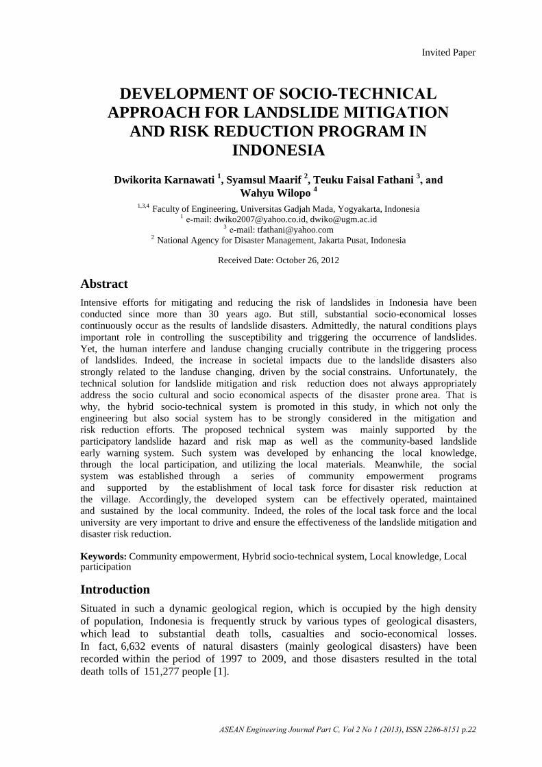
In response to the challenge for providing appropriate landslide mitigation and risk reduction in Indonesia, series of research activities have been conducted since 2004 to 2012, with the grand scenario as described in Figure 2. This research scenario relies on a socio-engineering approach, mainly supported by engineering geological investigations and analyses (i.e. engineering geological mapping, field investigation with geophysical exploration, and laboratory analysis), combined with the geotechnical as well as psychosocial investigations and analyses. The results of engineering geological investigations were crucial to identify the natural (geological) conditions controlling and triggering landslide, and also to analyze the respective mechanism. Meanwhile, the geotechnical investigation and analysis were important to predict the landslide occurrence and the threshold levels of triggering process, in order to define the threshold level of early warning. In parallel with the engineering geological and geotechnical investigations, a psychosocial investigation and analysis were carried out to support the development of an appropriate technology for landslide hazard mitigation and early warning system.
In this regard, the socio-technical approach has been developed through the whole research process, by integrating the engineering as well as the social investigations and analyses. As a result, the hybrid socio-technical system for landslide mitigation and early warning can be established [12], [13] and [14]. Finally, a smart grid technology as a community-cyber based landslide monitoring and early warning can be developed [15].
ASEAN Engineering Journal Part C, Vol 2 No 1 (2013), ISSN 2286-8151 p.25
Figure 2. Research method
Landslide Conditions in Indonesia
Situated in the dynamic geological conditions, where the mountain areas occupy more than 50% of the region and the annual rainfall mostly exceeds 2000-4000 mm, the progress of urbanization as well as deforestation in Indonesia has brought to the increasing risk of landslides. By nature, many slopes in the mountainous areas in Indonesia are susceptible for landslides. Such susceptibility is mainly driven by the integrated controls of morphology, stratigraphy, structural geology and hydrology of the slope ([7], [16], [17], [18] and [19]). The susceptible slopes are very sensitive to fail in response to the inducements of rain or water infiltration ([20] and [21]), seismic acceleration, and also human intervention, such as the uncontrolled slope overloading or slope cutting ([22] and [23]). Series of engineering geological investigations were conducted as a part of the research grand scenario illustrated in Figure 2. As a result, types of landslides in Indonesia can be re-classified mainly based on the mechanism and rate of movements, such as summarised in Table 1, and illustrated in Figure 3, Figure 4, Figure 5 and Figure 6. By understanding the mechanism, rate of movement, triggering process and also estimating the area of impact, the appropriate mitigation and risk reduction system can be developed.
ASEAN Engineering Journal Part C, Vol 2 No 1 (2013), ISSN 2286-8151 p.26
Table 1. Landslide Types in Indonesia Based on the Mechanism and Rate of Movements
No Landslide Types and
Rate of MovementGeological Conditions
Morphological (Terrain)
Conditions
Triggering
Processes Area of Impacts
1 Fall (rapid movement,more than 5 m/ sec)
a. Rock Fall(Figure 3a-left)
b. Earth Fall(Figure 3a-right)
a. Slightly weathered to freshjointed rock with twodifferent joint orientationsor more.
b. Soil or weathered jointedrock.
Very steep slope (steeper than 60o, mainly approaching 90o)
Water or rain infiltration Earthquake acceleration Slope excavation Overloading Landuse changing
The trajectory areawithin the radiusof 100 m.
The trajectory areacan exceed 1 kmdistance from thefailure surface.
2 Slide ((rapid movement,more than 5 m/sec)A. Planar failure plane.
a. Rock slidea. Jointed/bedded rocks as the
moving material, with thejoint and bedding dip as thesliding plane, directedtowards the slope-face orparallel to the slope dip.
Steep slope (steeper than 20o to 60o).
Rain*) or waterinfiltration
Earthquake acceleration Overloading, Excavation at the foot
sloped
Sliding distance may exceed 500 m from the head scarp (crown), depending on the slope steepnesss, earthquake
ASEAN Engineering Journal Part C, Vol 2 No 1 (2013), ISSN 2286-8151 p.27
Table 1. (Continued)
No Landslide Types and
Rate of MovementGeological Conditions
Morphological (Terrain)Conditions
Triggering
Processes Area of Impacts
b. Earth slide(Figure 4a-top)
c. Debris slide
B. Rotational failure planed. Earth slump
(Figure 6)
b. Thick residual soils orcolluvial as the movingmaterial (thicker than 4 m),usually overlain theimpermeable layer of tuff orclay as the sliding plane
c. Thick residual soils orcolluvial with boulders(thicker than 4 m), overlyingslightly to moderatelyweathered rock (sometimesjointed), so that the movingmaterial can be mix of soilsand rock materials
d. Thick (more than 4 m) andhomogeneous residual soils(rich in clay content).
Steep slope (20o to 60o)
Steep slope (20o to 60o)
Landuse changing
Rain *) or waterinfiltration
Earthquake
acceleration and the soil saturation.
100 – 500 m
ASEAN Engineering Journal Part C, Vol 2 No 1 (2013), ISSN 2286-8151 p.28
Table 1. (Continued)
No Landslide Types and
Rate of MovementGeological Conditions
Morphological (Terrain)
Conditions
Triggering
Processes Area of Impacts
e. Debris slump e. Thick (more than 4 m)and homogeneousresidual soils (rich inclay content and rockboulders)
Overloading, Slope excavation
Landuse changing
3 Flow (intermediate torapid movement, 1 to 5 m/sec)
a. Rock flow(Figure 3a-left)
b. Earth flow(Figure 4a-bottom)
c. Debris flow(Figure 4b-left)
a. Jointed or bedded rocks,with the joint and bedding dipdirected towards the slope-faceor parallel to the slope dip.
b. Thick residual soils orcolluvials (thicker than 4 m),which usually overlain theimpermeable layer of tuff orclay.
c. Thick residual soils orcolluvial with boulders (thickerthan 4 m),
Slope inclination less than 60o
Rain*)/ water infiltration Overloading, Excavation at the foot
sloped Earthquake acceleration
Flowing distance may exceed several kilometres downslope and reach the lowland area immediately below the steep hill or mountain slopes.
ASEAN Engineering Journal Part C, Vol 2 No 1 (2013), ISSN 2286-8151 p.29
No Landslide Types and
Rate of MovementGeological Conditions
Morphological (Terrain)
Conditions
Triggering
Processes Area of Impacts
overlying slightly to moderately weathered rock (sometimes jointed), so that the moving material can be mix of soils and rock materials
4 Creep (slow movement)- Due to the existence of saturated active clay/ expansive clay (rich of montmorillonite content) in residual soils or colluvial.
5 Combined- Combination of geological conditions described above.
Complex terrain conditions, consisting of steep to gentle slopes
Exceeding several hundred meters to several kilometers
*) single rain event exceeding 50-70 mm/hour or the antecedent rainfall (accumulation of several rain events) exceeding 100 mm.
ASEAN Engineering Journal Part C, Vol 2 No 1 (2013), ISSN 2286-8151 p.30
Table 1. (Continued)
Figure 3a. Rock falls (left) induced by the extreme rainal and earthquake (7.6 M) at the steep slope of the volcanic crater in Maninjau Lake, Nagari Tanjungsani, Agam
Regency, West Sumatera, which then developed as the rock flows at the gentle slope and lower land area; and the earth fall (right) induced by river erosion at Sleman Regency,
Yogyakarta
Figure 3b. Rock slide in Bawakaraeng mountain, south sulawdsi (Photo courtessy to central information Center of South Sulawesi Province)
Scarce of rock fall
Rock flow fl
owFlows
ASEAN Engineering Journal Part C, Vol 2 No 1 (2013), ISSN 2286-8151 p.31
Figure 4a. Rock Slide (top) induced by extreme rainfall and earthquake of 7.6 M at Tandikat Village, Padang Pariaman Regency, West Sumatera on September 30, 2009 which continuously developed as the earth flows (bottom) and resulted in two villages
and more than 100 people burried
Figure 4b. Debris flow (left) in Pacet Area, East Java, which buried the house and tourism area (right)
ASEAN Engineering Journal Part C, Vol 2 No 1 (2013), ISSN 2286-8151 p.32
Case of the Rain Combined with Earthquake Induced Earth Slides
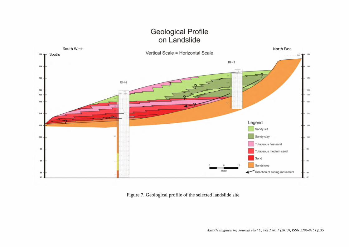
Among various types and mechanism of landsides, earth sliding is the most common one induced either by the rain and/or earthquke. One of the most catastrophic earthslides was in response to the West Sumatra earthquake on September 30, 2009 in combined with the extreme rainfall (Figure 4a and 6). The earthquake magnitude was 7.6 M [24], with the peak ground acceleration of 300 m gal for the duration of 7 seconds [25]. This disaster resulted in more than hundred people buried in Tandikat Village, Pariaman Regency. Accordingly, geological investigation was conducted to analyze the controlling factors and mechanism of the earth slides, in order to develop landslide susceptibility map used to support the relocation, mitigation and landuse management at the landslide prone area. It was identified that the existence of structural geology i.e. fault and lineament patterns, was the important controlling factor for landsliding, especially in creating the slope steepness (with 40o to 50o inclination) and jointed conditions in the tuffaceous sandstone. More over, the existence of unstable and thick residual soil (pumiceous sandy silt - sandy clay) as the blanket covering the steep slope of tuffaceous sandstone was very sensitive to slide downslope, when it was triggered by the extreme rain precipitation and earthquake acceleration. Based on the correlation of drilling logs illustrated in Figure 7 the geological profile of one selected landslide site (Figure 6) can be interpreted. Apparently, the sliding occurred along the zone with distinctive difference in engineering properties (i.e. the density, permeability and Standard Penetration Test Value), existed at the contact of dense tuffaceous sandstone and the loose residual soils (pumiceous sandy silt - sandy clay).
Figure 5. Subsidence induced by creep in tuffaceous silt-clay in Tengklik Village, Karanganyar Regency (left) and in Semarang, Central Java
ASEAN Engineering Journal Part C, Vol 2 No 1 (2013), ISSN 2286-8151 p.33
Figure 6. Steep slope with the inclination of 45o, formed by thick residual soils (pumiceous sandy silt-clay) and covered by coconut trees creates high susceptibility conditions for landslide occurrence at Tandikat Village, Pariaman Regency, West
Sumatra (drilling position was situated at BH1 and BH2)
In addition, slope stability analysis by using finite element model, i.e. the Slope/w Version 4.22 (2000) developed by Geoslope [26], was also conducted to support the analysis on triggering mechanism. Input data of soil engineering properties (Table 2) used for such analysis was provided from the soil mechanic laboratory tests, conducted on undisturbed soil samples. Such samples were collected from the borehole 1 (BH1) and borehole 2 (BH2) at the selected landslide site (Figure 6). The initial conditions of the simulated slope model (Figure 8a) applied in this slope stability analysis were defined based on the simplification of geological profile shown in Figure 7. Results of the analysis are illustrated in Figure 8b and 9.
It can be learned from Figure 8b that the landsliding was initiated when the pumiceous sandy silt – sandy clay and tufaceous sand (illustrated as the green zone) were fully saturated in response to a series of prolonged rainfall, at the same time with the earthquake triggering process which induced the Peak Ground Acceleration (PGA) of 0.30 g. This combined triggering mechanism immediately resulted in further liquefaction of the pumiceous sandy silt – sandy clay and tufaceous sand. That is why, the initiated earth slides (Figure 4a-top and 6) then developed as the continuous earth flows (Figure 4a-bottom), with the travelling distance exceeding 500 m down slope to the fluvial plane. However, from the graph in Figure 9 it can be seen that in dry condition (when the groundwater table height is 0 m above the potential failure surface), the larger PGA such as 740 m gal (0.74 g) is required to initiate the sliding in the slope.
ASEAN Engineering Journal Part C, Vol 2 No 1 (2013), ISSN 2286-8151 p.34
Figure 7. Geological profile of the selected landslide site
South West North East
ASEAN Engineering Journal Part C, Vol 2 No 1 (2013), ISSN 2286-8151 p.35
Table 2. Input Parameters of Soil and Rock Engineering Properties
Figure 8a. The initial conditions of the simulated slope, and b) the critical conditions in slope with fully saturated pumiceous sandy silt – sandy clay – tufaceous sand (in the
green zone) in response to the PGA 0.3 g, analyzed by slope/w version 4.22
1.000
Material #: 1
Material #: 2
Material #: 3
Material #: 4 Horz Seis mic Load: 0.307
84 m
27m 1
3
4
2
reference point of
groundwater level
vary
a)
b)
ASEAN Engineering Journal Part C, Vol 2 No 1 (2013), ISSN 2286-8151 p.36
Figure 9. Correlation between the groundwater level above sliding surface and the triggering PGA
Landslide Susceptibility Conditions
As a part of the mitigation and risk reduction program, results of the engineering geological and geotechnical investigations were elaborated to carry out the landslide susceptibility mapping at the same pilot study area in Tandikat Village, Pariaman Regency, West Sumatera Province. The susceptibility of landslide was analyzed by applying „weighting‟ and „scoring‟ on each parameter controlling the landslide occurrence. These controlling parameters included the slope inclination, geology (lithology), lineament and landuse conditions. The „weighting‟ of all the parameters was defined by adapting the method of Analytical Hierarchical Process proposed by [9], [27] and [28], depending upon the levels of importance of each parameter in controlling the landsliding. On the other hand, the „scoring‟ was determined based on the level of „unfavorable‟ condition of the respective parameter. Procedure and steps for analyzing the weighting to define the level of importance of each controlling parameter is illustrated in Figure 10. As a result, the landslide susceptibility levels and the respective susceptibility distributions can be predicted as presented in Figure 11. It is clearly indicated in the susceptibility map that the high susceptibiity zone of landslide (red zone) is strongly controled by the orientation of lineaments along the „trellis‟ river valleys. Thus, it is apparent that structural geological conditions play a significant role in controlling the distribution of landsliding. The resulted landslide susceptibility map is crucial to support the development of the landuse management, as well as the estblishment of landslide risk map for the risk management. This map is also required to decide the appropriate locations for the installation of early warning system as well as for the evacuation and relocation.
Slope Failure Line
y = -0.0011x2 - 0.0322x + 0.738
0
0.1
0.2
0.3
0.4
0.5
0.6
0.7
0.8
0 2 10 124 6 8Groundwater level (m)
PG
A c
oeff
icie
nt
ASEAN Engineering Journal Part C, Vol 2 No 1 (2013), ISSN 2286-8151 p.37
Figure 10. Procedure and steps for defining the weight value for each parameter, modified from [27]
Development of Hybrid-Socio Technical System
Most of landslide mitigations and risk reduction in Indonesia have been undertaken mainly based on the engineering and technical approaches. However, learning from series of socio-engineering investigations and analyses conducted under the grand research scenario illustrated in Figure 2, it was understood that social conditions of the landslide prone area played such important constrains in the implementation of the developed engineering and technical mitigation. Therefore, it is strongly recommended that the mitigation and risk reduction program must address both social and technical systems, in order to ensure the effectiveness and sustainability of such program. Accordingly, a combined (hybrid) system, which considers both technical and social aspects was suggested by [12],[13] and [14]. The technical system comprises several technical components such as the instruments for landslide early warning system recommended by [6], [10] and [11]. The system was also supported by the smart-grid for landslide hazard communication, monitoring and early warning developed by [15] as well as the community-based landslide hazard map suggested by [8]. Meanwhile, the social system was designed through public education and community empowerment program as the adaptive management efforts suggested by [5], [6], [9] and [14]. The schematic approach of this recommended concept is illustrated in Figure 12
ASEAN Engineering Journal Part C, Vol 2 No 1 (2013), ISSN 2286-8151 p.38
Figure 11. Landslide and flash flood susceptibility map where the high susceptibility zone (red zone) was controlled by slope lineament and steepness
ASEAN Engineering Journal Part C, Vol 2 No 1 (2013), ISSN 2286-8151 p.39
Figure 12. Concept of hybrid socio technical system ([12], [13], [14])
Technical System It is important that the technical system for landslide mitigation must rely on the simple technology with the low-cost, and developed from the local knowledge by the local participation of the local experts and operators, using the local materials. These technical systems may comprise several instruments as below:
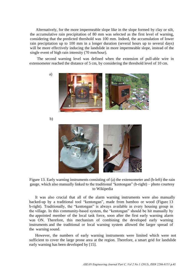
Early Warning InstrumentsThe early warning instruments consist of the extensometer (Figure 13a) to measure the ground surface deformation and the rain gauge (Figure 13b-left) to record the rain precipitation. Thus, the progress of crack development due to the slope movement as well as the accumulation of rain precipitation into the slope can be monitored by such instruments. Automatic alarm sensors were connected to all of the instruments, which were generated by dry battery and solar panel. Accordingly, when the slope movement and the rain precipitation reached a critical level, the alarm will automatically switched on. To facilitate the evacuation procedure, two different levels of warning were defined. The first alarm was set up for raising the community alert, and the second alarm was for executing the evacuation process. The first level of warning was set-up by an automatic switch-on alarm in response to the rain precipitation of 50 mm/hour, although the initiation of movement in rather permeable slope, such as in sandy silt, pumiceous silt or sand, was predicted at the threshold level of 70 mm/hour. The selection of lower level of warning than the predicted threshold level (i.e. 50 mm/hour instead of 70 mm/hour) was defined to allow sufficient duration for the evacuation process, such as one to several hours prior to the landslide event. In fact, the warning provided by the same model of extensometer product installed in Kalitelaga Village, Banjarnegara Regency, Central Java, was launched 4 hours prior to the landslide occurrence.
ASEAN Engineering Journal Part C, Vol 2 No 1 (2013), ISSN 2286-8151 p.40
Alternatively, for the more impermeable slope like in the slope formed by clay or silt, the accumulative rain precipitation of 80 mm was selected as the first level of warning, considering that the predicted threshold was 100 mm. Indeed, the accumulation of lower rain precipitation up to 100 mm in a longer duration (several hours up to several days) will be more effectively inducing the landslide in more impermeable slope, instead of the single event of high rain intensity (70 mm/hour).
The second warning level was defined when the extension of pull-able wire in extensometer reached the distance of 5 cm, by considering the threshold level of 10 cm.
a)
b)
Figure 13. Early warning instruments consisting of (a) the extensometer and (b-left) the rain gauge, which also manually linked to the traditional “kentongan” (b-right) – photo courtesy
to Wikipedia
It was also crucial that all of the alarm warning instruments were also manually backed-up by a traditional tool “kentongan”, made from bamboo or wood (Figure 13 b-right). Traditionally, the “kentongan” is always available in every housing group in the village. In this community-based system, the “kentongan” should be hit manually by the appointed member of the local task force, soon after the first early warning alarm was ON. Therefore, this mechanism of combining the developed early warning instruments and the traditional or local warning system allowed the larger spread of the warning sound.
However, the numbers of early warning instruments were limited which were not sufficient to cover the large prone area at the region. Therefore, a smart grid for landslide early warning has been developed by [15].
ASEAN Engineering Journal Part C, Vol 2 No 1 (2013), ISSN 2286-8151 p.41
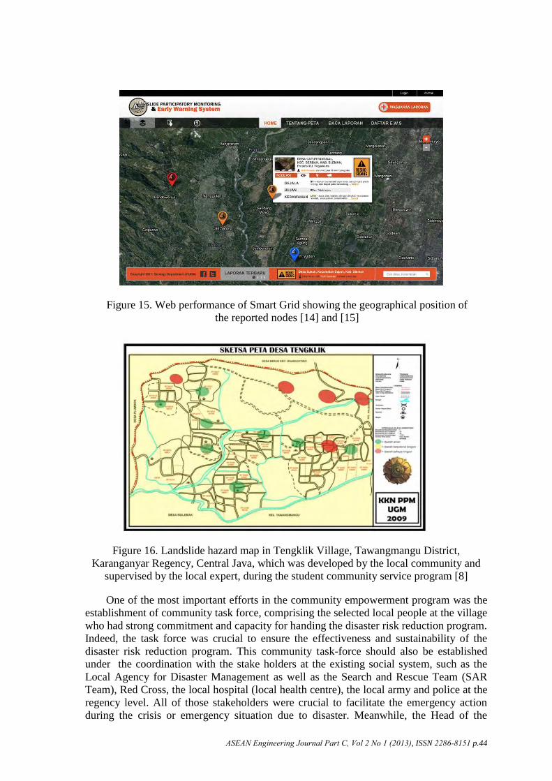
Smart Grid for Landslide Monitoring and Early WarningSmart Grid [15] is a tool to facilitate the participatory data reporting and recording system via the online web or various social media (mobile phone call/text, Twitter, Facebook, Google+, Yahoo, etc.). This tool was capable to handle the network of reporting or recording nodes, consisting of human sensor such as the local experts, local surveyor, or selected members of the local taskforce and the contact person in the local communities. The data recorded comprised the symptoms of landslides (the indicator of slope movements), the vulnerability of any reported area and the condition of rain precipitation. Such recorded data will be automatically transferred into the „online‟ web. Accordingly, the landslide hazard and risk level in any particular site can be defined based on the reported data obtained from the human sensors or the monitoring instruments. Results of the analyses then were transferred back to the reporting nodes as well as to the other relevant registered nodes, to provide the early warning and the emergency-decision supports related to the evacuation plan, route and shelter, as well as the recommended procedure for evacuation. Figure 14 shows the schematic concept of the smart grid, whilst the example of the web performance of smart grid is displayed in Figure 15.
Community-Based Hazard MapMost of the technical landslide susceptibility or hazard map (such as illustrated in Figure 11) is not easy to be understood by the local community. Simplicity of the mapping method and the visualization is the key aspect for ensuring the effective function of the map in supporting the disaster risk reduction program. Accordingly, [8] developed a simple and practical method for landslide hazard mapping, to allow community participations during the mapping process. This community map (Figure 16) was simply prepared and drawn on the pre-existing base-map of the village (i.e. the village “situation” map), which mainly illustrated the lay out of roads, rivers, houses and land farming areas, without any contour lines. This simplification made the local people enable to easily identify the position of their house in the produced map, and also be aware about the level of hazard or risk in their living environment. Determination of the hazard level such as the high level (red zone), low level or save level (green zone) was carried out by a group of selected community members (which is so called as the community task force) under supervision of the local landslide expert from the local university, local NGO, or local authority, through series of public education and participation processes. This produced hazard map is also very important to define the location for the instalment of the early warning instruments and the route for evacuation.
Social SystemThe development of social system was carried out through the community empowerment program (Figure 17), relying on public education to encourage community participation in developing and implementing the actions for disaster mitigation and risk reduction. Prior to the empowerment program, a social survey had been carried out to identify and assess the existing community‟s knowledge and wisdom about the landslide hazard, which may affect their perception on the importance of the landslide hazard and risk reduction programs.
ASEAN Engineering Journal Part C, Vol 2 No 1 (2013), ISSN 2286-8151 p.42
Figure 14. Schematic concept of expert system developed in Smart Grid [14] and [15]
In fact, this perception significantly drove the community‟s willingness to participate in the development of technology for landslide disaster risk reduction. Therefore, the results of social survey should be elaborated to develop appropriate public education program for encouraging community‟s motivation or willingness to actively participate in any disaster risk reduction actions. The main target groups for the community empowerment program included the groups of women (as the key person in the family), teachers, children as well as the young and key leaders.
Web System “expert system analysis” on:
Hazard Level
Low Moderate High
Risk Level
Low Moderate High
ASEAN Engineering Journal Part C, Vol 2 No 1 (2013), ISSN 2286-8151 p.43
Figure 15. Web performance of Smart Grid showing the geographical position of the reported nodes [14] and [15]
Figure 16. Landslide hazard map in Tengklik Village, Tawangmangu District, Karanganyar Regency, Central Java, which was developed by the local community and
supervised by the local expert, during the student community service program [8]
One of the most important efforts in the community empowerment program was the establishment of community task force, comprising the selected local people at the village who had strong commitment and capacity for handing the disaster risk reduction program. Indeed, the task force was crucial to ensure the effectiveness and sustainability of the disaster risk reduction program. This community task-force should also be established under the coordination with the stake holders at the existing social system, such as the Local Agency for Disaster Management as well as the Search and Rescue Team (SAR Team), Red Cross, the local hospital (local health centre), the local army and police at the regency level. All of those stakeholders were crucial to facilitate the emergency action during the crisis or emergency situation due to disaster. Meanwhile, the Head of the
ASEAN Engineering Journal Part C, Vol 2 No 1 (2013), ISSN 2286-8151 p.44
Village or an appointed key leader should take the lead and control this social system, especially to establish the command for “evacuation” when early warning was launched by the technical system. Concept of the management system for landslide early warning is schematically illustrated in Figure 18.
Figure 17. Community empowerment program with various target groups, such as a) the youth b) the local authority c) the women, and d) the school teacher and pupils,
conducted through the research-based student community service program
Figure 18. Schematic diagram of the management system on landslide early warning at the village level (modified from [6], [12] and [13])
a)
a)
b)
c) d)
EO-1 : Automatic Extensometer
Rain Gage
Ø Local Agency
for Disaster
Management
Ø Community
Task Force
Ø SAR
Ø Red cross
Ø Health center/
local hospital
Ø Army-Police
Head of Village
EARLY WARNING SYSTEMsupported by Technical + Social network
EO-2 : Automatic Extensometer
EM-1 : Manual Extensometer
EM-1 : Manual Extensometer
EM-1 : Manual Extensometer
Lo
ca
l co
mm
un
ity
Evacuation command
TECHNICAL SYSTEMSOCIAL SYSTEM
ASEAN Engineering Journal Part C, Vol 2 No 1 (2013), ISSN 2286-8151 p.45
Discussion: The Role of University
To ensure the appropriateness and effectiveness of the process for developing the hybrid socio-technical system, a science-based research action needs to be undertaken in combined with the community-based approach. Indeed, the role of the university is strongly demanded as the academic institution where the science and technology are continuously developed under the research and education program. The ignorance of science and academic-based approach may lead to inappropriate design of the mitigation technology, especially in terms of the accuracy and reproducibility. However, the main challenge faced by the university is how to bring the science-based research and education into practical actions, for solving the problems in disaster risk reduction. This challenge includes the assurance for providing effective applicability and sustainability in the implementation of developed technology. In this respect, the integration of research action into community engagement program is required, in order to facilitate the effective process of developing appropriate science and technology for handling the real problem in the community. This process can be conducted through various academic programs, such as the student community service program. This program has been regularly carried out as a compulsory interdisciplinary activities with 3 credits unit, embedded in the formal undergraduate curricula in Universitas Gadjah Mada since the 1970th. Recently, several pilot activities through the research-based student community service programs, in particular for the landslide mitigation and risk reduction, have been conducted in various villages in Yogyakarta, Central Java, West Java and West Sumatera. Through these pilot activities, the hybrid socio-technical system can be developed and implemented together with the community empowerment program. Indeed, it is important that not only the community can be empowered through this program, but also the student competence can also be enhanced during the community engagement program. Such competence mainly related to the student capability to bring science into practice, in order to tackle the interdisciplinary problems. Moreover, the transformation of positive attitude and ethical values can also be facilitated during this community service program.
ConclusionsMany efforts have been conducted to develop the technology for landslide mitigation and risk reduction in Indonesia, but those have not yet been successfully performed because of the socio-cultural constrains. Accordingly, it is obvious that the interdisciplinary approach, such as through the implementation of hybrid socio-technical system, is required to ensure the effectiveness and sustainability of the landslide mitigation and risk reduction program. The technical system should be developed in a simple and low cost performance by addressing the local knowledge and technology, and encouraging the local participation through the community empowerment or public education program. Meanwhile, the local task force is considered as the key-driving actor for ensuring the effectiveness, continuity and sustainability of the landslide mitigation and disaster risk reduction. This integrated approach may also be replicated to tackle similar disaster problems in other countries in Asia at the village or local level. It is also important that the local university should have an important role to initiate, encourage and facilitate this science-based community empowerment program, especially to support the quality assurance in the scientific and community - based research action.
ASEAN Engineering Journal Part C, Vol 2 No 1 (2013), ISSN 2286-8151 p.46
Acknowledgements
Special thanks are directed to the AUN/Seed Net and the Indonesian Ministry of Education and Culture for supporting the engineering geological and geotechnical research in this study. The acknowledgement should be extended to the Indonesian Agency for National Disaster Management, the United Nation Development Program and the International Consortium on Landslides for supporting the development of early warning system through series of pilot research. The gratitude thanks are also expressed to the British Council-Delphe Program for supporting the development of community-based landslide hazard mapping and to the Fulbright Senior Research Program for facilitating the development of Smart Grid. The great appreciation is then forwarded to Universitas Gadjah Mada for the provision of academic facilities, as well as to Chevron Indonesia, which provides support for the global dissemination of the research outputs. Finally, special thanks should be presented to Mr. Ahmad Yuniarto – The President of Schlumberger Indonesia as well as to Prof. Retno Sudibyo the senior researcher at Universitas Gadjah Mada, for the inspiring thoughts in developing the research approach and also for the research facilities provided during the emergency actions. Finally, the intensive and continuous assistance of Mr. Sani Tanaka Ismawanto is deeply appreciated.
References
[1] Annoname, “Landslide disaster databased,” Indonesian National Agency for DisasterManagement, 2009.
[2] Annoname, “Analysis of disaster data,” Indonesian National Agency for DisasterManagement, 2009.
[3] Annoname, “Natural disaster database,” Indonesian National Agency for DisasterManagement, 2012.
[4] B. Andayani, D. Karnawati, and S. Pramumijoyo, “Institutional framework forcommunity empowerment towards landslide mitigation and risk reduction inIndonesia,” In: Proceedings of the 1st World Landslide Forum: Parallel SessionVolume, International Strategy for Disaster Reduction (ISDR), and InternationalConsortium on Landslides (ICL), Tokyo, Japan, pp. 57-59, 2008.
[5] D. Karnawati, T.F. Fathani, B. Andayani, P.W. Burton, and I. Sudarno, “Strategicprogram for landslide disaster risk reduction: A lesson learned from Central Java,Indonesia Disaster Management and Human Health Risk; Reducing Risk, ImprovingOutcomes,” WIT Transactions on The Built Environment Transaction, Vol. 110:Disaster Management and Human Health Risk, K. Duncan and C.A. Brebbia, eds.,pp. 115-126, 2009.
[6] D. Karnawati, T.F. Fathani, B. Andayani, D. Legono, P.W. Burton, and I. Sudarno,“Landslide hazard and community-based risk reduction effort in Karanganyarand the surrounding area central Java, Indonesia,” Journal of Mountain Science, Vol.8, No. 2, pp. 149-153, 2011.
[7] D. Karnawati, I. Ibriam, M.G. Anderson, E.A. Holcombe, G.T. Mummery, J.P.Renaud, and Y. Wang, “An initial approach to identifying slope stability controls inSouthern Java and to providing community-based landslide warning information,” InLandslide Hazard and Risk, T. Glade, M.G. Anderson, and M.J. Crozier, eds.:John Wiley and Sons, pp. 733-763, 2005.
[8] D. Karnawati, W. Wilopo, and B. Andayani, “Development of community hazard mapfor landslide risk reduction,” In: Geologically Active: Proceedings of the11th International Association of Engineering Geologist Congress, CRC Press,Auckland, New Zealand, pp. 1203-1208, 2010.
ASEAN Engineering Journal Part C, Vol 2 No 1 (2013), ISSN 2286-8151 p.47
[9] E. Halcombe, S. Smith, E. Wright, and M.G. Anderson, “An integrated approach for evaluating the effectiveness of landslide risk reduction in unplanned communities in the Caribbean,” Natural Hazards, Vol. 61, No. 2, pp. 351-385, 2012.
[10] T.F. Fathani, D. Karnawati, K. Sassa, H. Fukuoka, and K. Honda,“Development of landslide monitoring and early warning system in Indonesia,” In: Proceedings of 1st World Landslide Forum: Parallel Session Volume, International Strategy for Disaster Reduction (ISDR), and International Consortium on Landslides (ICL), Tokyo, Japan, pp. 195-198, 2008.
[11] T.F. Fathani, and D. Karnawati, “Early warning of landslide for disaster risk reduction in Central Java Indonesia,” In: Proceedings of International Workshop on Early Warning for Landslide Disaster Risk Reduction in the Eastern Asian Region, Kunming, Yunnan, China, 2009.
[12] D. Karnawati, T.F. Fathani, B. Andayani, and Suharto, “The Hybrid Socio-technical approach as a strategic program for social development in geo-disaster prone Area in Indonesia,” World Academy of Science, Engineering and Technology, Vol. 66, pp. 18-21, 2010.
[13] D. Karnawati, T.F. Fathani, W. Wilopo, A. Setianto, and B. Andayani,“Promoting the hybrid socio-technical approach for effective disaster risk reduction in developing countries,” WIT Transactions on The Build Environment, Vol. 119, pp. 175-182, 2011.
[14] D. Karnawati, T.F. Fathani, W. Wilopo, A. Setianto, and B. Andayani,“Hybrid socio-technical approach for landslide risk reduction in Indonesia,” In Progress of Geo-Disaster Mitigation Technology in Asia, F. Wang, M. Miyajima, T. Li, W. Shan, and T.F. Fathani, eds.: Springer-Verlag Berlin, Heidelberg, Germany, pp. 157-169, 2013.
[15] D. Karnawati, E.G. Frost, T.F. Fathani, and Subroto, “Smart grid for landslide monitoring and early warning system in Indonesia,” In: Proceedings of the 10th Anniversary of the International Consortium of Landslides (ICL), Kyoto, Japan, 2012.
[16] W. Heath, and B.S. Sarosa, “Natural slope problems related to roads in Java, Indonesia,” In: The 2nd International Conference on Geomechanics in Tropical Soils, Singapore, pp.259-266, 1988.
[17] D. Karnawati. Mechanism of Rain-Induced Landsliding in Allopanic and Halloyaitic Soils in Java, Unpublished PhD Thesis, University of Leeds, United Kingdom, 1996.
[18] Kartodihardjo, “Alam tidak pernah lalai, Evaluasi banjir bandang di Pacet, Jawa Timur (The nature never careless; Evaluation on debris slide in Pacet, East Java),” 2003.
[19] S.S. Ky, The Scoring System for Landslide Risk Microzonation and the Mechanism of Weathered Tuff Layer in the Landslide Phenomena of Tropical Volcanic Area, Yogyakarta, Indonesia, Unpublished PhD Thesis, Gadjah Mada University, Indonesia, 2008.
[20] D. Karnawati, “Mechanism of rain-induced landsliding by using slope hydrodynamic numerical model,” Forum Teknik, Vol. 20, No.1, 1997.
[21] D. Karnawati, “Analysis of rain-induced landslide in volcanic – colluvial deposits, in Kalibawang irrigation channel, Yogyakarta, Indonesia,” Media Teknik, Vol. 29, No. 1, pp. 3-14, 2007.
[22] D.M. Cruden, and D.J. Varnes, “Landslide types and processes,” In Landslides: Investigation and Mitigation, Special Report 247 (Transportation Research Board -TRB, National Research Council), A.K. Turner and R.L. Schuster, eds.: , National Academy Press, Washington D.C., pp. 36 -75, 1996.
ASEAN Engineering Journal Part C, Vol 2 No 1 (2013), ISSN 2286-8151 p.48
ASEAN Engineering Journal Part C, Vol 2 No 1 (2013), ISSN 2286-8151 p.49
[23] T.P. Goestelow, “Rainfall and landslide, prevention and control of landslides and other mass movement,” In: M.E. Almeida-Taxeira, R. Fantechi, R. Oliveira, and A. Gomes Coelho, eds., Proceedings of the European School of Climatology and Natural Hazards, Commission of the European Communities (CEC) Report EUR 12918 EN, Lisbon, Portugal, pp. 139-161,1991.
[24] Annoname, “Significant earthquake archive,” United State Geological Survey, 2009.[25] Annoname, Badan Meteorologi, Klimatologi dan Geofisika (Indonesian Agency for
Meteorology, Climatology and Geophysics), 2009.[26] Geoslope International Ltd., Slope/w, Geoslope Version 4.22, 2000, Retrieved
from https://www.geoslope.com/products/slope-w[27] T.L. Saaty, The Analytical Hierarchy Process: Planning, Priority Setting, Resource
Allocation, McGraw-Hill, New York, United States, 1980.[28] S. Lacasse, and F. Nadim, “Landslide risk assessment and mitigation strategy,” In
Landslide - Disaster Risk Reduction. K. Sassa and P. Canuti, eds.: Springer Verlag, Berlin, Heidenberg, Germany, pp. 31-61, 2008.
[29] M.G. Anderson, E. Holcombe, M. Esquivel, J. Toro, and F. Ghesquiere, “The efficacy of a program of landslide risk reduction in area of unplanned housing in the Eastern of Caribbean,” Environmental Management, Vol. 45, No. 4, pp. 807-821, 2010.
[30] M.G. Anderson, E. Holcombe, J.R. Blake, F. Ghesquire, N. Holm-Nielsen, and T. Fisseha, “Reducing landslide risk in communities: Evidence for the Eastern Caribbean,” Applied Geography. Vol. 31, No. 2, pp. 590-599, 2011.