Page 1
Development Plan for Mirsharai Upazila, Chattogram District: Risk
Sensitive Land Use Plan (2017-2037)
VOLUME-I: STRUCTURE PLAN
June 2020
Urban Development Directorate
Ministry of Housing and Public Works
Government of the People’s Republic of Bangladesh
Page 2
Published By
Urban Development Directorate (UDD)
Ministry of Housing and Public Works
Government of the People’s Republic of Bangladesh
First Edition
June 2020
Price
BDT 3000.00
US$ 37.00
Printed By
Copyright
Urban Development Directorate (UDD)
No part of the document may be reproduced, stored in retrieval system or transmitted in any form
or by any means, electronic, mechanical, photocopying, recording on otherwise without permission
of the copyright holder.
Page 3
Gazette Notification
Page 5
Development Plan for Mirsharai Upazila,
Chattogram District: Risk Sensitive Land Use Plan Structure Plan Report
i
Acknowledgement
This is a great pleasure for all concerned that the “Preparation of Development Plan for Mirsharai
Upazila, Chattogram District: Risk Sensitive Land Use Plan” project has been successfully completed
by June, 2020 under the supervision of Urban Development Directorate (UDD), Ministry of Housing
and Public Works, Government of the People’s Republic of Bangladesh.
This Development Plan for the period of 20 years (2017-2037) will serve as a guideline for the future
Infrastructure Development together with risk sensitive land use control, effective development and
management of Mirsharai Upazila. This Development Plan comprises of four stages and tiers in a
hierarchical order. These are Structure Plan for 20 years, Urban Area Plan for 10 years, Rural Area
Plan for 10 years and selected Action Area Plan for 5 Years.
The appointed consulting firms have successfully completed the most essential tasks such as Physical
Feature Survey; Socio-economic Survey; Transportation Survey; Hydro-Geological Survey; Geological
Survey and baseline survey of Flora and Fauna for the preparation of Development Plan. The project
team has completed Participatory Rural Appraisal (PRA) and series of consultation meetings with
stakeholders for the preparation of the Plan. After preparing the draft Development Plan, local level
stakeholder consultation and workshop have been completed. Finally, formal public hearing has
been made to register public complaints and awareness through participatory planning approach
with the Upazila and related stake-holders. During implementation period if needed any change of
the development plan may be allowed with the approval of the appropriate authority.
Urban Development Directorate (UDD) acknowledges the full support and cooperation of Mirsharai
Upazila Authority, Member of Parliament, Mayors of both Baroiarhat and Mirsharai Paurashava,
Chairman of the Union Parishad, Stakeholders and Member of Civil Societies, member of University
Student Association of Mirsharai (USAM) and the common people of locality with the deepest
gratitude.
Ahmed Akhtaruzzaman
Project Director “Development Plan for Mirsharai Upazila, Chattogram
District: Risk Sensitive Land Use Plan” Project Urban Development Directorate (UDD) Ministry of Housing and Public Works
Government of the People’s Republic of Bangladesh
Page 6
Development Plan for Mirsharai Upazila,
Chattogram District: Risk Sensitive Land Use Plan Structure Plan Report
ii
Preface
Urban Development Directorate (UDD) under the Ministry of Housing and Public Works,
Government of the People’s Republic of Bangladesh prepares and co-ordinates Development Plan at
Upazila level. Presently Urban Development Directorate is working to enhance the quality of life of
the people by improving the environment through planned development activities and to ensure a
geographically balanced urbanization.
A Development Plan for Mirsharai Upazila is required so that no unauthorized and unplanned
development, either in urban area or in rural area, can take place. Hence, a comprehensive planning
package is essential to coordinate such development activities of various public agencies and private
organizations in a planned way.
Under the supervision of Urban Development Directorate (UDD), the project titled “Preparation of
Development Plan for Mirsharai Upazila, Chattogram District: Risk Sensitive Land Use Plan” has
been successfully completed by June, 2020. This Development Plan for the period of 20 years (2017-
2037) will serve as a guideline for the future Infrastructure Development together with risk sensitive
land use control, effective development and management of Mirsharai Upazila. The objective of this
Development Plan is integrating the rural area with the urban area in both physical and socio-
economic terms to implement rural-urban development. Therefore, the main purpose of preparing
this Development Plan for Mirsharai Upazila is to ensure rational use of scarce land resources for
concentrated development at rural and urban scale.
Finally, it is expected that this plan package will serve as a guideline to the future infrastructure
development of Mirsharai Upazila with risk sensitive land use control and effective management of
services and facilities. This will ensure planned, physical growth and socio-economic development of
Mirsharai Upazila.
Dr. K. Z. Hossain Taufique
Director Urban Development Directorate (UDD) Ministry of Housing and Public Works
Government of the People’s Republic of Bangladesh
Page 7
Development Plan for Mirsharai Upazila,
Chattogram District: Risk Sensitive Land Use Plan Structure Plan Report
iii
Executive Summary
The “Development Plan for Mirsharai Upazila, Chattogram District: Risk Sensitive Land Use Plan”
project envisages a new development plan for Mirsharai Upazila. Since the plan as envisaged
through the current project of Urban Development Directorate (UDD) is first of its kind in
Bangladesh, the local authorities at Upazila level has no previous experience of implementing such
plans which integrates both urban and rural areas. Both Baroiarhat and Mirsharai Paurashava have
previous experience in plan preparation and implementation. However, the Upazila and Union
Parishad have no experience of implementation of physical plans. The plan prepared through this
project will be their first experience of implementing the physical plans in their own areas.
The objective of this Development Plan is integrating the rural area with the urban area in both
physical and socio-economic terms to implement rural-urban development. Therefore, the main
purpose of preparing this Development Plan for Mirsharai Upazila is to ensure rational use of scarce
land resources for concentrated development at rural and urban scale as envisaged in the Terms of
Reference (ToR).
The report presents summary information and discussion on the survey results of various aspects of
the Upazila. The survey on Land Use, Physical Features, Socio-economic conditions, Topography,
Hydrology, Hazards, Environment, Agriculture, Drainage and Flood Control and Transportation have
provided useful data and information and are used in the Development Plan. This comprehensive
Development Plan contains Structure Plan, Urban and Rural Area Plan and Action Area Plan.
Structure Plan is prepared to provide flexibility through laying down the development strategies.
This stratum of the plan is developed for the whole project area. It has duration of 20 years. Urban
area plan is developed for duration of 10 years. Covering the two Paurashavas (Baroiarhat and
Mirsharai), urban area plan lays down the detailed land use proposals. Rural Area Plan is developed
for duration of 10 years. Finally, Action Area Plan has duration of 5 years. This plan identified both
regionally and locally important projects.
Mirsharai Upazila is situated in the Chattogram District under the Division of Chattogram with an
area of 482.88 sq. km including 133.14 sq. km forest area. It is located between 22º39´ and 22º59´
north latitudes, and 91º27´ and 91º39´ east longitudes. This Upazila consist of two Paurashava,
sixteen Unions, 109 populated Mauzas, and 208 Villages. Mirsharai Upazila is located 192.2 km far
from the Capital city Dhaka and 60 km far from the port city Chattogram.
About 66.33% land of the project area is covered by non-urban land uses (agricultural and forest
area). This depicts the rural characteristics of the project area. Around 15.17% lands are allocated for
residential purpose (Physical Feature Survey, 2017-2019). It is also to be mentioned here that
residential density in these areas are very low.
Page 8
Development Plan for Mirsharai Upazila,
Chattogram District: Risk Sensitive Land Use Plan Structure Plan Report
iv
In 2011, population of the project area was 398716 (BBS, 2011). The Structure Plan Report used
population data for a twenty year plan period in the future from the estimates of cohort method for
Upazila, Union, and Paurashava. Projected figure of the population is 488754 for the year 2037. As
per BBS, 2011, considering the average family size 5, total number of required housing units will be
97751. By the year 2037, total deficit of housing units will be 18206.
Summary of Policies
Mirsharai Upazila should be developed as an area of tourist zone and industrial hub of international
standard. Existing development of any nature which creates hindrance to the proposed policy should
be discouraged. The following sectoral policies will guide planned development of Mirsharai Upazila.
Housing
Policy 01 : Provision of adequate and affordable basic infrastructure and services
Policy 02 : Promote housing schemes for the low-income group and the industrial workers
Policy 03 : Discourage the housing development by destroying natural resources
Economy
Policy 01 : Enhancing agro-processing industry
Policy 02 : Ensure compact development of industrial and commercial growth
Policy 03 : Development of tourism sector
Policy 04 : Promote informal sector economic activities
Policy 05 : Facilitate development of ICT sector
Transportation and Communication
Policy 01 : Improvement of regional connectivity
Policy 02 : Provide a circular road to establish smooth vehicular traffic circulation
Policy 03 : Provide connectivity between Bangabandhu Sheikh Mujib Shilpanagar to Dhaka-
Chattogram national highways
Policy 04 : Construction of flyover at busiest intersection to avoid traffic congestion
Policy 05 : Improving internal transport network within the Upazila linking the Upazila
Headquarters with the Union Headquarter and Growth Center
Policy 06 : Establishment of safe walkways and bicycle path alongside with the major roads
Policy 07 : Developing a multi-modal local, regional and national transportation network
Water Resource Management
Policy 01 : Protection and preservation of wetland and natural water resources
Policy 02 : Provide buffer zone along river, khal and other water bodies
Policy 03 : Surface water bodies should be used as major sources of drinkable water supply to
residents in order to reduce dependence on groundwater
Policy 04 : Heavy withdrawal of ground water should not implement in the Bangabandhu
Sheikh Mujib Shilpanagar area
Policy 05 : Proposed artificial reservoirs should be investigated in detail for the
implementation of newly proposed reservoir
Disaster Management
Policy 01 : Preparation of comprehensive risk sensitive land use plan
Policy 02 : Protecting and maintaining the natural drainage system based on existing rivers
and khals
Policy 03 : Regular cleaning of drainage system and excavation of khals
Page 9
Development Plan for Mirsharai Upazila,
Chattogram District: Risk Sensitive Land Use Plan Structure Plan Report
v
Social and Community Facilities
Policy 01 : Ensure educational infrastructure to cover all over the Upazila
Policy 02 : Provision of playground at every educational institutions
Policy 03 : Provision of educational institute for ethnic groups
Policy 04 : Ensure technical and vocational training institutions at Upazila level
Policy 05 : Provision of community clinic in each union
Policy 06 : Use playgrounds as eidgah
Policy 07 : Ensure community-based graveyard/cremation ground
Urban Utility Services
Policy 01 : Promote development of water supply based on surface water
Policy 02 : Encourage harvesting of rain water
Policy 03 : Promote adequate hygienic public toilet facilities throughout the busy areas of
urban center
Policy 04 : Provide affordable and hygienic sanitation for the lower income people
Policy 05 : Introduction of community-based waste collection system
Policy 06 : Generate innovative ideas to convert waste into resource
Policy 07 : Provision of solid waste collection point and waste disposal ground in a suitable
location
Policy 08 : Ensure effective management and disposal of medical waste
Policy 09 : Promote alternative source of energy like solar panel, biogas
Tourism and Recreation Facilities
Policy 01 : Development of tourism support services and infrastructure facilities
Policy 02 : Promotion of local heritage based tourism
Policy 03 : Encouraging eco-tourism development
Policy 04 : Creation of waterfront facilities and green areas
There are different types of thematic maps were prepared based on 6 types of survey during the
survey stage. Each survey has distinct output. The outputs of survey works were presented in the
form of thematic maps. The thematic maps are Digital Elevation Model (DEM), existing Land Use,
Road type, cropping pattern, Salinity level in deep water, groundwater recharge area, foundation
depth, etc.
Suitability analysis is a prime requirement for the preparation of development plan of any urban and
rural areas. There are two types suitability maps were prepared after analyzing the suitability of the
existing features. Through this analysis suitable area for infrastructure and infrastructure
development were identified.
The Structure Plan provides the policies that will guide the future development of Mirsharai Upazila.
In the Structure Plan, 33641.87 acres (28.14%) land is kept as rural settlement area and 18316.56
acres (15.32%) land is kept as a forest area. Besides, economic zone (10.54%), private housing area
(5.80%), mixed use (7.51%), circulation network (1.84%), urban area (1.28%), urban extension area
(4.18%), rural settlement area (6.44%), water-body (8.19%), and water supply protection zone
(8.04%) areas are earmarked on the Structure Plan to support the future need for food and other
development purposes of the Upazila.
Page 10
Development Plan for Mirsharai Upazila,
Chattogram District: Risk Sensitive Land Use Plan Structure Plan Report
vi
It should be kept in mind that this development plan is a guideline for the development and control
of growth in a systematic manner. The existing Local Government Acts for Upazila Parishad,
Paurashava, and Union Parishad have provided authorities, responsibilities, and scope of planned
development in their respective areas. The Upazila Parishad has legal responsibilities and
opportunities for coordinating development within the Upazila. Without proper regulations or rules,
it would not be possible to implement this development plan. However, the Urban Development
Directorate (UDD) needs to play its role as a supervising authority for the execution of the suggested
plans and policies as per law.
Page 11
Development Plan for Mirsharai Upazila,
Chattogram District: Risk Sensitive Land Use Plan Structure Plan Report
vii
STRUCTURE PLAN REPORT
Table of Contents
Acknowledgement .......................................................................................................... i
Preface ......................................................................................................................... ii
Executive Summary ....................................................................................................... iii
Table of Contents ......................................................................................................... vii
List of Tables ................................................................................................................ xi
List of Figures .............................................................................................................. xii
List of Maps ................................................................................................................ xiii
List of Photographs ..................................................................................................... xiv
Acronyms .................................................................................................................... xv
Glossary of Terms ...................................................................................................... xvii
CHAPTER 01: INTRODUCTION ....................................................................................... 1
1.1 Introduction ............................................................................................................................ 1
1.2 Background of the Project ...................................................................................................... 1
1.3 Description of the Project Area............................................................................................... 2
1.4 Objective of the Project .......................................................................................................... 4
1.5 Methodological Approach to Plan Preparation ...................................................................... 4
1.6 Content of the Development Plan Report .............................................................................. 7
CHAPTER 02: CONCEPT OF STRUCTURE PLAN ................................................................ 8
2.1 Introduction ............................................................................................................................ 8
2.2 Objective of the Structure Plan ............................................................................................... 8
2.3 Methodology for the Preparation of Structure Plan............................................................... 8
2.4 Area Coverage of the Structure Plan ...................................................................................... 9
2.5 Duration and Amendment of the Structure Plan .................................................................... 9
CHAPTER 03: EXISTING CONDITIONS ........................................................................... 11
3.1 Introduction .......................................................................................................................... 11
3.2 Demography and Population Growth ................................................................................... 11
3.3 Socio-economic Profile ......................................................................................................... 11
3.3.1 Family Size .................................................................................................................... 11
3.3.2 Educational Status ........................................................................................................ 12
3.3.3 Religious Group ............................................................................................................ 12
Page 12
Development Plan for Mirsharai Upazila,
Chattogram District: Risk Sensitive Land Use Plan Structure Plan Report
viii
3.3.4 Employment Pattern .................................................................................................... 12
3.3.5 Income and Savings Pattern ......................................................................................... 13
3.3.6 Need and Demand Oriented Area ................................................................................ 14
3.4 Existing Land Use Pattern ..................................................................................................... 16
3.5 Physical Feature .................................................................................................................... 18
3.6 Physical Infrastructure .......................................................................................................... 20
3.6.1 Road Network .............................................................................................................. 20
3.6.2 Major Intersections ...................................................................................................... 20
3.7 Participatory Rural Appraisal (PRA) ...................................................................................... 24
3.7.1 Key Observations from PRA ......................................................................................... 25
CHAPTER 04: REVIEW OF NATIONAL POLICIES, LAWS AND REGULATIONS ..................... 30
4.1 Introduction .......................................................................................................................... 30
4.2 Review of Relevant National Polices ..................................................................................... 30
4.3 Review of Relevant Laws and Regulations ............................................................................ 53
CHAPTER 05: PROJECTION OF POPULATION ................................................................. 56
5.1 Introduction .......................................................................................................................... 56
5.2 Projection of Population ....................................................................................................... 56
5.2.1 Cohort Survival Method of Population Projection ....................................................... 56
5.2.2 Calculation of Population Projection ........................................................................... 57
5.2.3 Projected Population Distribution ............................................................................... 58
5.3 Estimation of Population Density ......................................................................................... 59
5.4 Limitation of Cohort Survival Method .................................................................................. 60
5.5 Conclusion ............................................................................................................................. 60
CHAPTER 06: ECONOMY ............................................................................................... 61
6.1 Introduction .......................................................................................................................... 61
6.2 Existing Scenario ................................................................................................................... 61
6.3 Future Plan and Direction ..................................................................................................... 61
CHAPTER 07: HOUSING ............................................................................................... 64
7.1 Introduction .......................................................................................................................... 64
7.2 Existing Scenario ................................................................................................................... 64
7.3 Housing Requirements .......................................................................................................... 64
7.4 Future Plan and Direction ..................................................................................................... 65
CHAPTER 08: TRANSPORTATION AND COMMUNICATION ............................................... 68
8.1 Introduction .......................................................................................................................... 68
8.2 Existing Condition of Transport Network .............................................................................. 68
8.2.1 Existing Public Transport Scenario ............................................................................... 68
Page 13
Development Plan for Mirsharai Upazila,
Chattogram District: Risk Sensitive Land Use Plan Structure Plan Report
ix
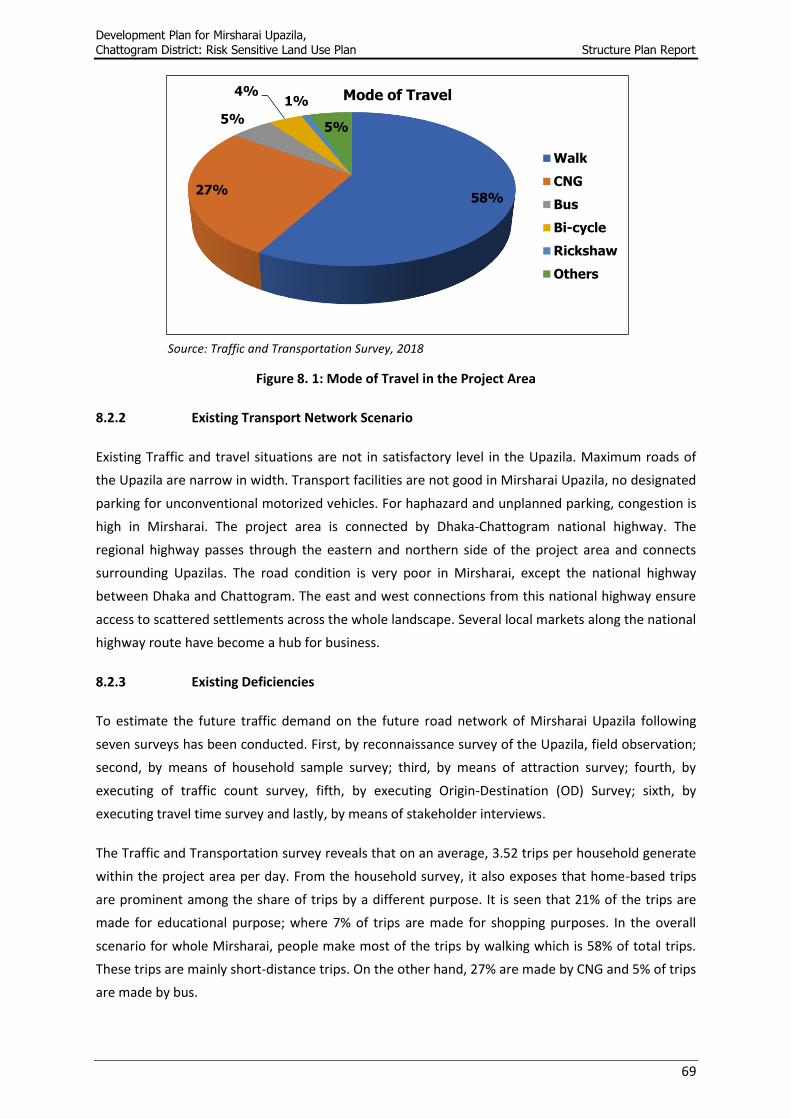
8.2.2 Existing Transport Network Scenario ........................................................................... 69
8.2.3 Existing Deficiencies ..................................................................................................... 69
8.3 Transportation and Communication-related Policies ........................................................... 70
CHAPTER 09: WATER RESOURCE MANAGEMENT ............................................................ 76
9.1 Existing Conditions ................................................................................................................ 76
9.2 Policy Recommendations ...................................................................................................... 76
CHAPTER 10: DISASTER MANAGEMENT ......................................................................... 83
10.1 Existing Conditions ................................................................................................................ 83
10.2 Policy Recommendations ...................................................................................................... 83
CHAPTER 11: SOCIAL AND COMMUNITY FACILITIES ...................................................... 86
11.1 Introduction .......................................................................................................................... 86
11.2 Existing Scenario ................................................................................................................... 86
11.3 Future Plan and Direction ..................................................................................................... 86
11.3.1 Educational Facilities .................................................................................................... 86
11.3.2 Health Care Facilities .................................................................................................... 88
11.3.3 Community Facilities .................................................................................................... 88
CHAPTER 12: URBAN UTILITY SERVICES ....................................................................... 90
12.1 Introduction .......................................................................................................................... 90
12.2 Existing Scenario ................................................................................................................... 90
12.3 Future Plan and Direction ..................................................................................................... 91
12.3.1 Water Supply ................................................................................................................ 91
12.3.2 Sanitation ..................................................................................................................... 91
12.3.3 Solid Waste Management ............................................................................................ 92
12.3.4 Electric Supply .............................................................................................................. 94
12.3.5 Gas Supply .................................................................................................................... 95
CHAPTER 13: TOURISM AND RECREATION FACILITIES .................................................. 96
13.1 Introduction .......................................................................................................................... 96
13.2 Existing Condition ................................................................................................................. 96
13.3 Tourism and Recreation Facilities Related Policies ............................................................... 98
CHAPTER 14: PUBLIC PARTICIPATIONS....................................................................... 101
14.1 Introduction ........................................................................................................................ 101
14.2 Public Participation in Planning .......................................................................................... 101
14.3 Participatory Rapid Appraisal (PRA) .................................................................................... 101
14.3.1 PRA Methodology ...................................................................................................... 102
14.3.2 Scenario of the Project Area ...................................................................................... 103
14.4 Participation of Young Generation ..................................................................................... 105
Page 14
Development Plan for Mirsharai Upazila,
Chattogram District: Risk Sensitive Land Use Plan Structure Plan Report
x
14.5 Conclusion ........................................................................................................................... 106
CHAPTER 15: STRUCTURE PLAN ................................................................................. 107
15.1 Introduction ........................................................................................................................ 107
15.2 Objectives of the Structure Plan Area ................................................................................. 107
15.3 Formulation of Thematic Maps ........................................................................................... 107
15.3.1 Digital Elevation Model (DEM) ................................................................................... 107
15.3.2 Cropping Pattern ........................................................................................................ 109
15.3.3 Groundwater Quality ................................................................................................. 109
15.3.4 Surface Geology ......................................................................................................... 112
15.3.5 Foundation Depth ...................................................................................................... 116
15.3.6 Soil Type ..................................................................................................................... 118
15.3.7 Building Height Recommendation ............................................................................. 119
15.4 Suitability Analysis .............................................................................................................. 122
15.4.1 Infrastructure Suitability ............................................................................................ 122
15.5 Structure Plan Zoning .......................................................................................................... 124
CHAPTER 16: PLAN IMPLEMENTATION ........................................................................ 128
16.1 Introduction ........................................................................................................................ 128
16.2 Legal Framework for Implementation ................................................................................ 128
16.3 Custodian of the Plan .......................................................................................................... 128
16.4 Capacity Building ................................................................................................................. 129
16.5 Role of Urban Development Directorate ............................................................................ 129
16.6 Monitoring, Review and Updating of the Plan Components .............................................. 129
16.7 Circulation of the Plan Documents ..................................................................................... 129
16.8 Implementation Modalities ............................................................................................... 130
CHAPTER 17: CONCLUSION ........................................................................................ 131
17.1 Concluding Remarks ............................................................................................................ 131
REFERENCES ............................................................................................................. 132
ANNEXURE-A: PROJECT TEAM .................................................................................... 133
ANNEXURE-B: PHOTOGRAPHS .................................................................................... 134
Page 15
Development Plan for Mirsharai Upazila,
Chattogram District: Risk Sensitive Land Use Plan Structure Plan Report
xi
List of Tables
Table 1.1: Detail Description of the Project Area ................................................................................... 2
Table 3. 1: Family Size of the Project Area ............................................................................................ 11
Table 3. 2: Educational Profile of the Project Area ............................................................................... 12
Table 3. 3: Status of the Religious Group .............................................................................................. 12
Table 3. 4: Employment Profile ............................................................................................................. 13
Table 3. 5: Distribution of Per Capita Income ....................................................................................... 13
Table 3. 6: Distribution of Monthly Savings .......................................................................................... 14
Table 3. 7: Existing Land Use Pattern of Mirsharai Upazila .................................................................. 16
Table 3. 8: Structure Use Scenario of Mirsharai Upazila ...................................................................... 18
Table 3. 9: Scenario of Structure Type in Mirsharai Upazila ................................................................. 18
Table 3. 10: Existing Road Type by Construction in Mirsharai Upazila ................................................. 20
Table 3. 11: Major Intersections in Mirsharai Upazila .......................................................................... 20
Table 3. 12: List of Sorted Problems of Urban and Rural Area ............................................................. 26
Table 5. 1: Decadal Growth Rate of Population (1951-2001) ............................................................... 57
Table 5. 2: Union-wise Population Projection of Mirsharai Upazila (2017-2037) ................................ 58
Table 5. 3: Union-wise Population Density of Mirsharai Upazila .......................................................... 59
Table 7. 1: Projected Housing Requirements (Dwelling Units) in Mirsharai Upazila ............................ 65
Table 8. 1: Distribution of Intra-zonal and Inter-zonal Trips ................................................................. 70
Table 14. 1: PRA Sessions in Different Sectors .................................................................................... 102
Table 15. 1: Cropping Pattern of Mirsharai Upazila ............................................................................ 109
Table 15. 2: Definition of Site Class Based on Vs30 - According to NEHRP (National Earthquake Hazard
Reduction Program, USA) Provisions .................................................................................................. 118
Table 15. 3: Sub-soil, Vs30 based Classification of the Soils ............................................................... 119
Table 15. 4: Land Use Classification for Infrastructure Development ................................................ 122
Table 15. 5: Structure Plan Zoning Category ...................................................................................... 124
Page 16
Development Plan for Mirsharai Upazila,
Chattogram District: Risk Sensitive Land Use Plan Structure Plan Report
xii
List of Figures
Figure 1.1: Overall Planning Methodology ............................................................................................. 5
Figure 1.2: Flow Diagram of Planning Process ........................................................................................ 6
Figure 5. 1: Projected Population Growth Trend in Mirsharai Upazila ................................................. 58
Figure 8. 1: Mode of Travel in the Project Area .................................................................................... 69
Figure 15. 1: Legend and Lithological Characteristic of Sub-surface of Mirsharai Upazila ................. 116
Page 17
Development Plan for Mirsharai Upazila,
Chattogram District: Risk Sensitive Land Use Plan Structure Plan Report
xiii
List of Maps
Map 1.1: Location of the Project Area in Respect of Bangladesh........................................................... 3
Map 2. 1: Boundary of the Structure Plan Area .................................................................................... 10
Map 3. 1: Need and Demand Oriented Area of Mirsharai Upazila ....................................................... 15
Map 3. 2: Existing Land Use Scenario of Mirsharai Upazila .................................................................. 17
Map 3. 3: Structure Type of Mirsharai Upazila ..................................................................................... 19
Map 3. 4: Road Network Type of Mirsharai Upazila ............................................................................. 23
Map 7. 1: Proposed Strategic Locations for Housing in Mirsharai Upazila ........................................... 67
Map 8. 1: Proposed Road Network for Mirsharai Upazila .................................................................... 75
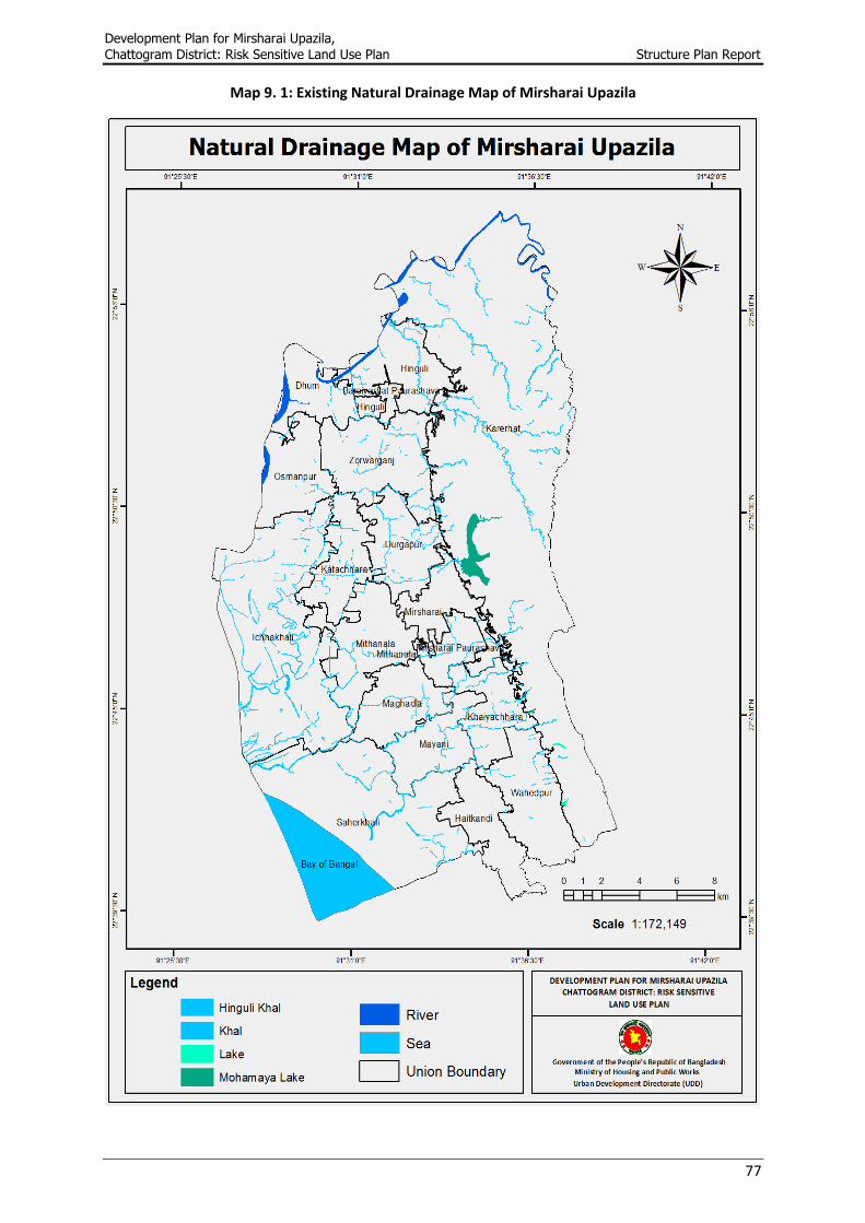
Map 9. 1: Existing Natural Drainage Map of Mirsharai Upazila ............................................................ 77
Map 9. 2: Proposed Drainage Facilities of Mirsharai Upazila ............................................................... 82
Map 14. 1: Intensity of PRA Problems in Mirsharai Upazila ............................................................... 104
Map 15. 1: Digital Elevation Model (DEM) of Mirsharai Upazila ........................................................ 108
Map 15. 2: Cropping Pattern of Mirsharai Upazila ............................................................................. 110
Map 15. 3: Arsenic in Deep Water Level of Mirsharai Upazila ........................................................... 111
Map 15. 4: Salinity in Shallow Level of Mirsharai Upazila .................................................................. 113
Map 15. 5: Groundwater Recharge Area of Mirsharai Upazila ........................................................... 114
Map 15. 6: Surface Geology Map of Mirsharai Upazila ...................................................................... 115
Map 15. 7: Foundation Depth of Mirsharai Upazila ........................................................................... 117
Map 15. 8: Soil Type Map of Mirsharai Upazila .................................................................................. 120
Map 15. 9: Building Height Recommendation Area of Mirsharai Upazila .......................................... 121
Map 15. 10: Infrastructure Suitability of Mirsharai Upazila ............................................................... 123
Map 15. 11: Structure Plan of Mirsharai Upazila ................................................................................ 127
Page 18
Development Plan for Mirsharai Upazila,
Chattogram District: Risk Sensitive Land Use Plan Structure Plan Report
xiv
List of Photographs
Photograph 3. 1: Baroiarhat Intersection ............................................................................................. 21
Photograph 3. 2: Chaitanner Hat Intersection ...................................................................................... 21
Photograph 3. 3: Mithachhara Intersection ......................................................................................... 22
Photograph 3. 4: Mirsharai Intersection and Zila Road towards Fatikchhari from the Mirsharai
Intersection ........................................................................................................................................... 22
Photograph 3. 5: Conducting PRA at Khaiyachhara Union ................................................................... 24
Photograph 3. 6: Conducting PRA at Ward No. 04 of Mirsharai Paurashava ....................................... 24
Photograph 3. 7: Conducting PRA at Ward No. 05 of Baroiarhat Paurashava ..................................... 24
Photograph 3. 8: List of Problems Collected from PRA of Durgapur Union ......................................... 25
Photograph 3. 9: List of Problems Collected from PRA at Ward No. 03 of Mirsharai Paurashava ....... 25
Photograph 3. 10: Major Problems Identified from Hinguli Union PRA ............................................... 26
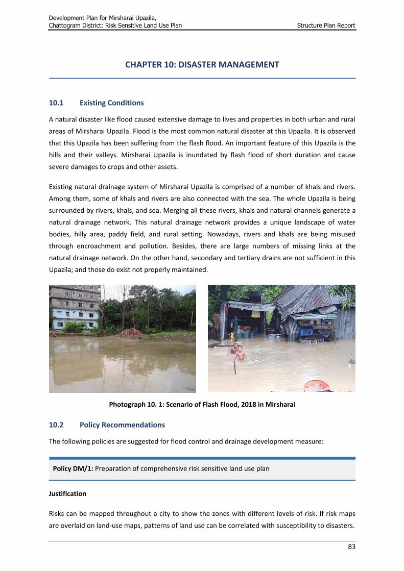
Photograph 10. 1: Scenario of Flash Flood, 2018 in Mirsharai ............................................................. 83
Photograph 13. 1: Khaiyachhara Waterfall ........................................................................................... 97
Photograph 13. 2: Drone Survey Image of Mohamaya Lake ................................................................ 97
Photograph 14. 1: PRA Session with Women Participant ................................................................... 103
Photograph 14. 2: PRA Session with University Student Association of Mirsharai (USAM) ............... 105
Photograph 14. 3: Art Competition under this Project at Mirsharai Upazila ..................................... 105
Page 19
Development Plan for Mirsharai Upazila,
Chattogram District: Risk Sensitive Land Use Plan Structure Plan Report
xv
Acronyms
BBS Bangladesh Bureau of Statistics
BEZA Bangladesh Economic Zone Authority
BIWTA Bangladesh Inland Water Transport Authority
BM Bench Mark
BRTC Bangladesh Road Transport Corporation
BSCIC Bangladesh Small and Cottage Industries Corporation
BTCL Bangladesh Telecommunications Company Limited
BWDB Bangladesh Water Development Board
CBOs Community Based Organizations
CFS Country Freight Service
DFI Direct Foreign Investment
DoE Department of Environment
DoF Department of Forest
DPHE Department of Public Health Engineering
EPZ Export Processing Zone
EZ Economic Zone
FWC Family Welfare Center
GED General Economics Division
GDP Gross Domestic Product
GIS Geographic Information System
HSC Higher Secondary Certificate
HQ Head Quarter
ICD Inland Container Depot
ICT Information and Communication Technology
IMTP Integrated Multimodal Transport Policy
LGED Local Government and Engineering Department
MoA Ministry of Agriculture
MoDMR Ministry of Disaster Management and Relief
Page 20
Development Plan for Mirsharai Upazila,
Chattogram District: Risk Sensitive Land Use Plan Structure Plan Report
xvi
MoI Ministry of Industry
MoHFW Ministry of Health and Family Welfare
MoHPW Ministry of Housing and Public Works
MoL Ministry of Law
MoWR Ministry of Water Resources
NGO Non-Government Organization
NHA National Housing Authority
O-D Origin - Destination
PDB Power Development Board
PPP Public Private Partnership
PRA Participatory Rural Appraisal
REB Rural Electrification Board
RHD Roads and Highways Department
SLR Sea Level Rise
SSC Secondary School Certificate
STS Secondary Transfer Station
TMC Technical Management Committee
ToR Terms of Reference
UDD Urban Development Directorate
UHC Upazila Health Complex
Page 21
Development Plan for Mirsharai Upazila,
Chattogram District: Risk Sensitive Land Use Plan Structure Plan Report
xvii
Glossary of Terms
Baor : The term “baor” means any kind of ox-bow shaped lake where water course
has become stagnant in course of time.
Bazaar :
Bazaar is a Market Place almost synonym of hat with some advanced facilities
in comparison to hat. Generally, in a hat, there may not be any permanent
business/trading house, shops. However, in a bazaar, there are some
permanent trading houses, shops, these shops are open every day, and buyers
and sellers attend the bazaar from morning till late evening.
Haor : The term “haor” means any saucer shaped large shallow depression created
naturally in-between two separate rivers.
Hat :
The term ‘hat’ is very much known to all from time immemorial throughout the
country which is a temporary rural market place. In rural area, farmers and
other producers used to sit with their surplus products in a suitable place
having comparatively better communication system with adjacent villages to
exchange these goods. This suitable place is called hat where generally on fixed
days sellers and buyers get together and exchange goods and services. This
gathering place is developed gradually by the local people at the beginning. The
Hat is a rural trading center.
Katcha : Temporary in nature
Khal : Any passage of inflow and outflow of water.
Mauza : Mauza is the smallest unit of Land Survey system with a unique number called
Jurisdiction List Number (J.L. No.).
Paurashava :
Paurashava is the local name of Municipality. The incorporated area
administered by the government as urban area under the Paurashava
Ordinance 2008 is considered as the Paurashava.
Pucca : Permanent in nature
Semi-pucca : Semi-Permanent in nature
Tempo : Human Hauler
Union : Smallest local administrative unit of rural area which is composed of Mauzas
and Villages.
Upazila : Sub-District administrative area.
Village : Smallest geographic area of rural area. A village may be same as mauza or
there may be more than one village in a mauza.
Page 22
Development Plan for Mirsharai Upazila,
Chattogram District: Risk Sensitive Land Use Plan Structure Plan Report
xviii
Ward :
Smallest local administrative unit of urban area. For the operational
convenience, Municipalities are divided into nine or more wards. The Ward
boundaries are specified by gazette notifications.
Zila : District administrative area
Page 23
Development Plan for Mirsharai Upazila,
Chattogram District: Risk Sensitive Land Use Plan Structure Plan Report
1
CHAPTER 01: INTRODUCTION
1.1 Introduction
As a local government unit most of the Upazila Parishad has not yet capable of integrating the rural
areas with the urban area in both physical and socio-economic terms to implement planned rural-
urban development. Due to lack of practicing effective development planning, these Upazila
Parishad have been measurably failed to put in order spatially the most valuable resource i.e., the
land of the towns in view of the citizens’ socio-economic and cultural needs of the citizens. The land
is used most haphazardly. As such, the developments are taking place in an unplanned and
unregulated manner resulting in a low living standard of the people living in the urban and rural
areas. The ties between urban and rural economies have been acting crucial in promoting
widespread development in the developed world. Thus, the overall situation of these Upazilas
depicts an underdeveloped scenario which needs to be developed based on their potentialities.
In the government’s recent policy of overall administrative re-organization, the Upazila has been
recognized as the most significant tier of the administration. By considering the above circumstance,
a comprehensive development plan is required to address the required land use transformation
which will not allow any unauthorized and unplanned development, either in an urban area or in a
rural area. In a view of this circumstance, it appears that the comprehensive development plan of
Upazila Parishad is very much important.
1.2 Background of the Project
Mirsharai Upazila located only 60 km away from the port city Chattogram, is a land of various
possibilities. With the smooth communication by all means of road, rail and waterways, it is a
potential location for economic cum industrial development. In addition, Mirsharai is blessed with
excellent geographical advantage making it a suitable location to establish a bay terminal for the
Chattogram Port Authority. The work of establishing one of the largest economic zone Bangabandhu
Sheikh Mujib Shilpanagar have also started in Mirsharai. Again, the proposed Special Economic Zone
would generate many industry related new activities including huge vehicular traffic on air, rail,
road, and water. This phenomenon would have both positive and negative impact on the socio-
economic condition and existing land use pattern of the region.
At the same time, Mirsharai is blessed with abundance of natural resources and scenic beauties
having hilly forest areas, hill streams and waterfalls of Chattogram Hill Tracts on one side and the
Bay of Bengal on the other. Mirsharai sea beach, hilly area, Mohamaya Chhara Lake, Khaiyachhara
region has the greater potential for tourism development as there are abundant resources to attract
the tourists. In tourism sector with holistic planning and establishment of easy accessibility,
Mirsharai can be a great tourist attraction. These are the key drivers of change for the Upazila under
study.
Page 24
Development Plan for Mirsharai Upazila,
Chattogram District: Risk Sensitive Land Use Plan Structure Plan Report
2
Mirsharai Upazila is developing in an unplanned and haphazard manner very rapidly due to the
ample opportunity for tourism development, which is acting as pull factor for private sector
developers. Hence, this project has been under taken to protect the region from depletion of its
natural resources and character and tourism development as well.
The Government of the People’s Republic of Bangladesh funded the current project with the Urban
Development Directorate (UDD), under the Ministry of Housing and Public Works (MoHPW) as the
executing agency. The project is managed, monitored, and evaluated by UDD at the field level. The
Technical Management Committee (TMC) at the organization level is responsible for looking into the
technical and coordination aspects, where the Inter-Ministerial Steering Committee is responsible
for guiding the project towards its goal.
1.3 Description of the Project Area
Mirsharai came into existence as a Thana in 1901 and was upgraded to a Upazila in 1983. Mirsharai
Upazila is situated in the Chattogram District under the Division of Chattogram with an area of
482.88 sq. km including 133.14 sq. km forest area. It is located between 22º39´ and 22º59´ north
latitudes, and 91º27´ and 91º39´ east longitudes. The Upazila is bounded on the north by Tripura
state of India and Chhagalnaiya and Feni Sadar Upazilas of Feni Zila, east by Fatikchhari Upazila,
south by Sandwip channel, Sitakundu, and Sandwip Upazilas and west by Feni River, Companiganj,
and Sonagazi Upazilas of Noakhali Zila (BBS, 2011).
Mirsharai Upazila is located 192.2 km far from the Capital city Dhaka and 60 km far from the port
city Chattogram. At Mirsharai Upazila, Feni River; Sandwip Channel; Ichhakhali, Mahamaya,
Domkhali, Hinguli and Mayani Khal are notable water bodies (Banglapedia). The hills range on the
northern and eastern side of this Upazila along the bank of the Feni River extended up to
Chattogram and the Chattogram hill tracts. A detailed description of the project area is given in
Table 1.1. Location of the project area in respect of Bangladesh is presented in Map 1.1.
Table 1.1: Detail Description of the Project Area
Municipality Union Mauza Village Population Urbanization Density per sq.km
2 16 109 208 3,98,716 7.83% 826
Source: BBS, 2011
Page 25
Development Plan for Mirsharai Upazila,
Chattogram District: Risk Sensitive Land Use Plan Structure Plan Report
3
Map 1.1: Location of the Project Area in Respect of Bangladesh
Page 26
Development Plan for Mirsharai Upazila,
Chattogram District: Risk Sensitive Land Use Plan Structure Plan Report
4
1.4 Objective of the Project
The objective of the project is to optimize resources and activities for sustenance of marginal people.
The activities and resources are very important to the economy and life of the people of Bangladesh
whose living conditions are inextricably linked to the productivity and sustainability of the region.
There is no long-term holistic development plan for the project area. Coastal zone needs to be
integrated with the mainstream of development process of the country. Therefore, an
interdisciplinary development planning approach is urgent to optimize livelihood of the region. The
Physical development planning problems, needing attention, are as follows:
To integrate ecology, economy, and social resources with the mainstream of development
process of the country.
To frame policies for the best use of land and its control for the Mirsharai Upazila.
To optimize environment for sustenance of people.
Formulation of policies and plans for mitigation of different types of hazards, minimizing the
adverse impacts of climate change and recommend possible adaptation strategies for the
region.
Formulation of policies and plans for gradual nucleation of settlements with policies and
plans for development of growth centers of the area.
Formulation of a guideline for development of tourism in Mirsharai Upazila and also
accommodation of future changes in existing land use pattern, socio-economic condition of
the area and quality of life of the people.
1.5 Methodological Approach to Plan Preparation
Different approaches and methodologies were followed for the preparation of Development Plan of
Mirsharai Upazila. The Development Plan package was followed in different stages - from
mobilization of the project to finalization of the plan. Collection of mauza maps and secondary
documents, conduction of different surveys, application of 3D Photogrammetric technology for
preparation of base-map and GIS database, consultation with stakeholders, fixation of planning
standards, review of secondary information, review of national policies and laws and preparation of
planning documents were the key approaches and methodologies. Structure Plan was prepared
based on the agreed planning standards and land use categories. Development proposals of
Mirsharai Upazila were made considering different propositions on future growth and development.
The overall planning methodology has been presented in Figure 1.1.
Page 27
Development Plan for Mirsharai Upazila,
Chattogram District: Risk Sensitive Land Use Plan Structure Plan Report
5
Figure 1.1: Overall Planning Methodology
The detailed discussions of approaches and methodologies are made in the following paragraphs.
Flow diagram of detail planning process is illustrated in Figure 1.2.
In the first step the conceptualization, mobilization, and operationalize the activities were carried
out and the output was the preparation of Mobilization Report. Collection of maps, basic statistics
and information, preparation of base map, demarcation of project boundary, mauza map
procurement, establishment of GCP and BM, digitization and Geo-referencing of mauza map, 3-D
satellite image processing was carried out and second stage was the preparation of an Inception
Report.
In third stage, a detailed survey has been carried out in order to know the existing condition of the
surveyed area. Different type of survey and studies were conducted and prepare a database and get
an insight into the existing conditions. PRA demand analysis has been done then and after that,
consultation meeting has been carried out about the findings and for proposing development plans.
On the basis of findings of the studies, survey report was prepared.
Page 28
Development Plan for Mirsharai Upazila,
Chattogram District: Risk Sensitive Land Use Plan Structure Plan Report
6
Figure 1.2: Flow Diagram of Planning Process
Socio-economic
Survey
Physical Feature, Land Use,
& Topographic Survey
Hydro-Geological
Survey PRA Survey
Transportation &
Traffic Survey
Geological Survey & Seismic
Hazard Assessment
Inception Report
Survey Activities
Mobilization Report
Preparation of Development Plan
Preparation
Mobilization Conceptualization Reconnaissance Survey
Collection of Maps, Basic
Statistics & Information
Preparation of Base
Map
Demarcation of Project
Boundary
Digitization & Geo-
referencing of Mauza Map
3-D Satellite Image
Processing
Establishment of
GCP & BM
Mauza Map
Procurement
Survey Report
Identification
of Problem
Formulation of All
Working Paper
Formulation Planning
Standard & Policies
Development of
Alternative Strategies
Workshop Preparation of
Draft Plan
Exchange of
Opinion
Review of Plans &
Strategies
Public
Hearing
Final Plan & Report
Flora & Fauna
Survey
Page 29
Development Plan for Mirsharai Upazila,
Chattogram District: Risk Sensitive Land Use Plan Structure Plan Report
7
Fourth stage was review of Survey and PRA findings for making draft plan. Reviews were made by
exchange of opinion with the cross section, people and stakeholders either groups or individual
basis. Important task or activities in this step was to formulate strategies, policies, and preparing
plans for all stages like Structure Plan, Urban Area Plan, Rural Area Plan, and Action Area Plans for
selected areas. After that, a draft plan has been prepared and workshops were arranged. Public
hearing was included in order to know the plan’s usefulness in local level and then Final plan has
been prepared.
Fifth and Final step was review and evaluation of the Strategies, Plans, feedback and opinion of
experts and public hearing. After compilation of all the opinion, the Final Plan has been prepared.
1.6 Content of the Development Plan Report
The Development Plan Report of Mirsharai Upazila is organized into four major parts with an
Introduction chapter at the beginning. The four major parts contain various components of work.
The four major parts of the Development Plan of Mirsharai Upazila are as follows:
Chapter One: This chapter describes the background information on selecting project along with
justification, description of the project area, planning methodology, and content of the Development
Plan report.
Chapter Two: This chapter describes the objectives of the Structure Plan, methodology for the
preparation of Structure Plan, duration and amendment of the Structure Plan.
Chapter Three: This chapter describes existing conditions of the project area including socio-
economic profile, existing land use pattern, physical feature, physical infrastructure and key
observations from Participatory Rural Appraisal (PRA).
Chapter Four: This chapter presents the review of the different type of national policies, laws, act,
and regulations which are relevant to this physical development planning process of Mirsharai
Upazila.
Chapter Five: This chapter describes the basis of population projection, projection method, the
rationale for selecting the population projection method, estimation of population density of
Mirsharai Upazila.
Chapter Six to Thirteen: These chapters describe sectoral polices of Structure Plan including
economy, housing, transportation and communication, water resource and management, disaster
management, social and community services, urban utility services, and tourism and recreation
facilities of Mirsharai Upazila.
Chapter Fourteen: This chapter describes about public participations including methodology of the
PRA, problems scenario of the project area and participations through social media.
Chapter Fifteen: This chapter describes about the formulation of the thematic maps, suitability
analysis and Structure Plan zoning of Mirsharai Upazila.
Chapter Sixteen: This chapter describes about the concluding remarks of the Structure Plan report.
Page 30
Development Plan for Mirsharai Upazila,
Chattogram District: Risk Sensitive Land Use Plan Structure Plan Report
8
CHAPTER 02: CONCEPT OF STRUCTURE PLAN
2.1 Introduction
The Structure Plan delivers long term strategy for the 20 years to 2037 for the development of
Mirsharai Upazila. It sets a long-term indicative and flexible strategy that will show the future
direction of coordinated development and will serve as the framework for local level plans. The
Structure Plan contains of a report which is a policy document with various supporting maps and an
appropriate scale composite map depicting the key elements of the major strategic decisions.
2.2 Objective of the Structure Plan
The purpose of the Structure Plan is to outline a preferred pattern of development from the
perspective of the Upazila authority as a service provider and planning authority. The main objective
of the Structure Plan is to provide sector-wise policy guidelines for two Paurashavas and all the
sixteen unions of Mirsharai Upazila. The objectives of the Structure Plan are as follows:
An inventory of existing physical, demographic, economic, and social and infrastructure
features;
An analysis of the major existing problems;
Estimation of trends and changes likely in the future (for the next 20 years);
The identification of the major constraints on and opportunities for development;
Consideration of the major development options and policies;
An indication of the most suitable areas for such development;
The identification of the priorities in each sector and the major activities needed to
implement the development strategy.
The Structure Plan consists of a package of policies dealing with the main aspects of development
over the next 20 years and defines a complete set of policies and strategies with an aim to achieve
the overall objectives of the Structure Plan. The structure plan concentrates on the broad structure
of the Upazila and is not concerned with the details of physical layout or individual development
details which cannot be implemented until the later stages of the planning period.
2.3 Methodology for the Preparation of Structure Plan
The whole preparation process of Structure Plan for Mirsharai Upazila has been illustrated and
described as follows:
Planning Area Demarcation
Planning area has been demarcated for the Structure Plan as the existing Upazila area. The total
Structure Plan area is covered by two Paurashavas named as Baroiarhat Paurashava, Mirsharai
Page 31
Development Plan for Mirsharai Upazila,
Chattogram District: Risk Sensitive Land Use Plan Structure Plan Report
9
Paurashava and all the sixteen unions named as Dhum Union, Durgapur Union, Haitkandi Union,
Hinguli Union, Ichhakhali Union, Karerhat Union, Katachhara Union, Khaiyachhara Union, Mayani
Union, Mirsharai Union, Mithanala Union, Maghadia Union, Osmanpur Union, Saherkhali Union,
Wahedpur Union, and Zorwarganj Union.
Projection of Population
After demarcating the planning area, the population of the Structure Plan area has been projected
from 2017 to 2037 based on census data of 2011.
Review of Existing Development Growth and Pattern
To understand the existing development pattern and growth, existing conditions of Mirsharai
Upazila has been reviewed in respect of different sectors. To reveal the existing situation several
surveys have been done.
Review of National Policies
Development Plan related all the relevant and recently updated national policies, acts, and laws
have been reviewed in respect of different sectors. Relevant strategies and targets of national
policies have been incorporated into the national policy review chapter.
Adapted Sectoral Policies and Strategies
After reviewing the relevant national policies, major policies and strategies have been proposed
sector-wise.
Public Consultation
Public Consultation is an essential element of participatory planning approach. In order to
understand the problem and prepare the plan, several formal and informal meetings were arranged
with the Upazila as well as stakeholders.
2.4 Area Coverage of the Structure Plan
The total Structure Plan area of Mirsharai Upazila is 493.60 sq. km. (as per GIS database). The
jurisdiction area for the Structure Plan is covered by all the sixteen unions and two Paurashavas of
Mirsharai Upazila (vide Map 2. 1).
2.5 Duration and Amendment of the Structure Plan
The Structure Plan of Mirsharai Upazila under Development Plan will be valid for a period of 20 years
from the time of its approval by the government. Thereby, it will be valid up to the year 2037.
Structure Plan can be amended every fifth year. However, after each of the amendment, the
Structure Plan must be approved by the Authority.
Page 32
Development Plan for Mirsharai Upazila,
Chattogram District: Risk Sensitive Land Use Plan Structure Plan Report
10
Map 2. 1: Boundary of the Structure Plan Area
Page 33
Development Plan for Mirsharai Upazila,
Chattogram District: Risk Sensitive Land Use Plan Structure Plan Report
11
CHAPTER 03: EXISTING CONDITIONS
3.1 Introduction
The key purpose of the structure plan is to provide policy guidelines to resolve the existing problems
of Mirsharai Upazila. This chapter presents the summary information on the existing conditions of
development and critical planning issues to be considered in the planning and development
processes of the project area. The major issues are the demography and population growth, land use
pattern, physical infrastructures, transportation, environment, drainage, and disaster management.
3.2 Demography and Population Growth
The total population of Mirsharai Upazila was 368950 in 2001 (BBS, 2001), with 183358 as male and
185592 as female. In 2011, this population figure rose to 398716 (BBS, 2011). Using the census data
of 2001 and 2011, the growth rate of population for this Upazila has been calculated. Based on the
population growth rate, the population of Mirsharai Upazila has been projected for the year 2037.
According to the population projection, the project area has a total population of 488754 for the
year 2037 (Please see detail in Table 5.3 in Chapter-5).
According to the census data (2011), it is noticeable that the household size of Mirsharai Upazila is
4.99 which were 5.34 in 2001. According to the census data (2011), Mirsharai Paurashava has the
lowest average household size (4.5) and Saherkhali Union has the highest average household size
(5.4). Among the project area, household size is usually smaller in more urbanized areas.
3.3 Socio-economic Profile
3.3.1 Family Size
The predominant family size in the project area is 6-9. The next important group is family with 1-5
members. These two groups together constitute about 91.60 percent families. Table 3. 1 represents
the details of family size in the project area as has been found from the socio-economic survey.
Table 3. 1: Family Size of the Project Area
Family Size Number of Households Percentage (%)
1-5 519 38.40
6-9 718 53.20
10-14 93 6.90
15-19 17 1.30
20 and above 3 0.20
Total 1350 100.00
Source: Socio-economic Survey, 2018
Page 34
Development Plan for Mirsharai Upazila,
Chattogram District: Risk Sensitive Land Use Plan Structure Plan Report
12
3.3.2 Educational Status
Among the surveyed households in the project area 23.31% are illiterate, around 33.08% have only
primary level education. The most observable fact is that only 2.00% of the project area’s
populations have honors, master, or higher level of education. Educational status of the project area
is presented in Table 3. 2.
Table 3. 2: Educational Profile of the Project Area
Educational Status Number of Persons Percentage (%)
Illiterate 303 23.31
Primary 430 33.08
Junior Secondary 133 10.23
SSC/Dakhil 268 20.62
HSC/Alim 79 6.08
Degree/Honors/Fazil 61 4.69
Masters or Higher 17 1.31
Technical 9 0.69
Total 1300 100.00
Source: Socio-economic Survey, 2018
3.3.3 Religious Group
Distribution of population by religion in the project area is shown in the Table 3. 3. Persons of all
three religions Islam, Hindu, and Buddhist are available in the project area; although Muslims
overwhelmingly dominate and account for more than 85%. Hindus are around 13.80% and Buddhist
around 1.20%.
Table 3. 3: Status of the Religious Group
Religion Number of Households Percentage (%)
Muslim 1148 85.00
Hindu 186 13.80
Buddhist 16 1.20
Total 1350 100.00
Source: Socio-economic Survey, 2018
3.3.4 Employment Pattern
The occupation pattern of the project area’s population is a very diversified. From the occupational
pattern it is found that percentage of people engaged in the traditional agricultural sector is
comparatively low (12.15%). Business is one of the main occupations of the people of the area and
8.46% people are engaged in it. Household work indicating housewives is the single most common
field of employment in the project area with the figure of 39.46%. Occupational pattern of the
project is presented in Table 3. 4.
Page 35
Development Plan for Mirsharai Upazila,
Chattogram District: Risk Sensitive Land Use Plan Structure Plan Report
13
Table 3. 4: Employment Profile
Categories Number of Persons Percentage (%)
Agriculture 158 12.15
Business (Small/Medium) 110 8.46
Construction Work 36 2.77
Day Labor 96 7.38
Government Job 36 2.77
Housewife 513 39.46
Skilled labor 24 1.85
Private Job 43 3.31
Self-independent 215 16.54
Student 51 3.92
Transport Work 18 1.38
Total 1300 100.00
Source: Socio-economic Survey, 2018
3.3.5 Income and Savings Pattern
Income and expenditure pattern of population reflect their socio-economic status and the status of
the area as well. The income-expenditure pattern also refers to the savings status of the selected
population. It is observed that about 3.63% respondent’s monthly income is below Taka 5000, about
19.33% respondent’s monthly income is Taka 5001-10000, about 22.07% respondent’s monthly
income is below Taka 10001-15000. About 2.81% respondent’s monthly income is more than Taka
50000. Per capita income profile of the household head in the project area is shown in Table 3. 5.
Table 3. 5: Distribution of Per Capita Income
Range of per capita income
(in Taka) Number of Persons Percentage (%)
<5000 49 3.63
5001-10000 261 19.33
10001-15000 298 22.07
15001-20000 228 16.89
20001-25000 188 13.93
25001-30000 112 8.30
30001-35000 70 5.19
35001-40000 50 3.70
40001-45000 28 2.07
45001-50000 28 2.07
50000> 38 2.81
Total 1350 100.00
Source: Socio-economic Survey, 2018
Pattern of household monthly savings of the project area is presented in Table 3. 6. What we see
from the table is that around 75.11% of residents have no savings. On the other hand, only 9.04% of
residents have less than Tk. 1000 monthly savings. Another significant phenomenon is that about
2.74% of residents have more than Tk. 7000 monthly savings. This indicates the high inequality in the
Page 36
Development Plan for Mirsharai Upazila,
Chattogram District: Risk Sensitive Land Use Plan Structure Plan Report
14
distribution of monthly income in the project area and that refers to diversified socio-economic
classes as well.
Table 3. 6: Distribution of Monthly Savings
Range of per capita Savings (in Taka)
Frequency Percentage (%)
<1000 1014 75.11
1001-2000 122 9.04
2001-3000 69 5.11
3001-4000 39 2.89
4001-5000 10 0.74
5001-6000 53 3.93
6001-7000 6 0.44
7000> 37 2.74
Total 1350 100.00
Source: Socio-economic Survey, 2018
3.3.6 Need and Demand Oriented Area
In a general sense, need usually refers to the fundamental necessities essential for our survival or at
least to maintain a minimum standard of living. However, if our affordability goes high, we can
dream for more and that creates demand. In developing countries like Bangladesh, it is very unlikely
to find a lot of people having the fancy opportunity of demand, rather than struggling just to fulfill
the marginal daily survival amenities they need. To map the Need and Demand oriented areas in
Mirsharai Upazila we formed a GIS based model. As extreme high-income group with huge level of
affordability is pretty rare and even certain level of rich people having the ability to afford demand
are not too available, we can categorize 6, 7, 8 scored areas as demand-oriented areas and 1 to 5 as
need oriented areas. In Mirsharai Upazila, only small portions of the areas were found as demand-
oriented area. Need and demand-oriented area of Mirsharai Upazila is presented in Map 3. 1.
Page 37
Development Plan for Mirsharai Upazila,
Chattogram District: Risk Sensitive Land Use Plan Structure Plan Report
15
Map 3. 1: Need and Demand Oriented Area of Mirsharai Upazila
Page 38
Development Plan for Mirsharai Upazila,
Chattogram District: Risk Sensitive Land Use Plan Structure Plan Report
16
3.4 Existing Land Use Pattern
The Land use survey was carried out by recording the current use of the land in the project area. The
current use of land was classified according to provision given in the Terms of Reference (ToR). Land
use survey basically records the use of land by its functional activity such as agricultural,
administrative area, commercial, circulation network, educational, forest, industrial, residential,
water body, etc. The generalized land use pattern in the study area has been sub-divided into 17
major categories. Land use composition of the project area is showed in Table 3. 7.
Table 3. 7: Existing Land Use Pattern of Mirsharai Upazila
Land Use Type Area (Acre) Percentage (%)
Administrative 16.32 0.01
Agricultural 46479.87 39.92
Commercial 332.06 0.29
Community Services 125.85 0.11
Economic Zone 8914.27 7.66
Education & Research 136.95 0.12
Forest 30752.39 26.41
Healthcare Facility 6.50 0.01
Industrial Area 233.22 0.20
Miscellaneous 10.47 0.01
Mixed Use 14.40 0.01
Recreational Area 7.54 0.01
Residential 17665.80 15.17
Circulation Network 1292.78 1.11
Service Activity 21.50 0.02
Vacant Land 290.51 0.25
Waterbody 10140.63 8.71
Total 116441.08 100.00
Source: Land Use Survey, 2017-2019
From land use analysis, it is found that the project area is rural in nature. Out of the total area,
around 39.92% of land in the Upazila is under agricultural use. Agricultural category ranks highest in
terms of land use area of the project area. Forest area ranks second highest in terms of area and
occupy 26.41% of land. Residential category ranks third highest in terms of area and occupies
15.17% of land. It is also to be mentioned here that residential density in these areas are very low.
Besides water bodies occupies 10140.63 acres of land that constitutes only 8.71% of total land use.
Circulation network within the project area is 1292.78 acres, which constitute 1.11% of the project
area. Only 0.12% land of the project area is used for education and research purpose. There are few
processing and manufacturing industries which occupy only 0.20% of total land use. Besides,
8914.27 acres of land is dedicated for special economic zone named Bangabandhu Sheik Mujib
Shilpanagar. Map 3. 2 present the existing land use scenario of the project area.
Page 39
Development Plan for Mirsharai Upazila,
Chattogram District: Risk Sensitive Land Use Plan Structure Plan Report
17
Map 3. 2: Existing Land Use Scenario of Mirsharai Upazila
Page 40
Development Plan for Mirsharai Upazila,
Chattogram District: Risk Sensitive Land Use Plan Structure Plan Report
18
3.5 Physical Feature
To know the existing situations of physical features of Mirsharai Upazila a detailed physical feature
survey was carried out and provisions of Terms of Reference (TOR) were followed. Physical features
were surveyed using Photogrammetric survey technique from 3D Stereo Satellite Images.
The Physical Feature survey reveals that there are in total of 161968 nos. structures exists in
Mirsharai Upazila. Residential structures are found to be the highest in number and accounts for
about 90.98% of total structures. Table 3. 8 show the existing structure use of the project area.
Table 3. 8: Structure Use Scenario of Mirsharai Upazila
Structure Use No of Structures Percentage (%)
Administrative 345 0.21
Commercial 6643 4.10
Community Service 1725 1.07
Education & Research 1226 0.76
Health Facility 115 0.07
Industrial 1610 0.99
Mixed Use 292 0.18
Residential 147352 90.98
Service Activity 432 0.27
Under Construction 2228 1.38
Total 161968 100.00
Source: Physical Feature Survey, 2017-2019
From the Physical feature survey, it is revealed that the majority of the structures in the Upazila are
katcha (77.81%). Table 3. 9 shows the structure type of the project area. Existing Structure Type
scenario of Mirsharai Upazila is presented in Map 3. 3.
Table 3. 9: Scenario of Structure Type in Mirsharai Upazila
Structure Type No of Structures Percentage (%)
Katcha 126035 77.81
Semi-Pucca 17251 10.65
Pucca 18553 11.45
Under Construction 129 0.08
Total 161968 100.00
Source: Physical Feature Survey, 2017-2019
Page 41
Development Plan for Mirsharai Upazila,
Chattogram District: Risk Sensitive Land Use Plan Structure Plan Report
19
Map 3. 3: Structure Type of Mirsharai Upazila
Page 42
Development Plan for Mirsharai Upazila,
Chattogram District: Risk Sensitive Land Use Plan Structure Plan Report
20
3.6 Physical Infrastructure
3.6.1 Road Network
Physical feature survey shows that Mirsharai Upazila is served by a road network of 1763.42 km.
From the construction point of view, these roads are divided into katcha, semi-pucca, and pucca
road. The highest 97.41% roads are pucca road. Existing road type in the project area is presented in
Table 3. 10.
Table 3. 10: Existing Road Type by Construction in Mirsharai Upazila
Road Type Length (KM) Percentage (%)
Katcha Road 18.53 1.05
Semi-Pucca Road 27.17 1.54
Pucca Road 1717.73 97.41
Total 1763.42 100.00
Source: Physical Feature Survey, 2018
3.6.2 Major Intersections
The Traffic and Transportation survey identified major intersections, in particular those intersections
that are important from the viewpoint of the entire road network or that are heavily congested. List
of major existing intersections in Mirsharai Upazila is presented in Table 3. 11.
Table 3. 11: Major Intersections in Mirsharai Upazila
Intersection Intersection Type Vehicle
Baroiarhat
(Baroiarhat Paurashava) 4-way intersection
Auto-rickshaw, leguna, tempo, mini-bus,
non-motorized vehicles
Zorwarganj
(Zorwarganj Union) 3-way intersection Auto-rickshaw, non-motorized vehicles
Chaitanner Hat
(Durgapur Union 3-way intersection Auto-rickshaw, non-motorized vehicles
Mithachhara
(Mirsharai Union) 3-way intersection Auto-rickshaw, non-motorized vehicles
Mirsharai
(Mirsharai Paurashava) 4-way intersection Auto-rickshaw, non-motorized vehicles
Bara Takiya Bazar
(Khaiyachhara Union 3-way intersection
Auto-rickshaw, leguna, tempo, mini-bus,
non-motorized vehicles
Sarkar Hat
(Wahedpur Union) 3-way intersection
Auto-rickshaw, leguna, tempo, mini-bus,
non-motorized vehicles
Source: Traffic and Transportation Survey, 2018
Page 43
Development Plan for Mirsharai Upazila,
Chattogram District: Risk Sensitive Land Use Plan Structure Plan Report
21
Baroiarhat Intersection
Baroiarhat intersection is 3-way intersection (T-type). Santir Hat road (Upazila road) is connected
with Dhaka-Chattogram Highway and creates T-type intersection. Besides, old Dhaka-Chattogram
road and regional highway toward Ramgarh (R151) are connected with Dhaka-Chattogram Highway
and creates four leg intersections.
Photograph 3. 1: Baroiarhat Intersection
Chaitanner Hat Intersection
Chaitanner Hat intersection is 3-way intersection (T-type). Ahmed Kabir Chowdhury road
(Chaitanner Hat - Abur Hat) is connected with national Dhaka Chattogram Highway.
Photograph 3. 2: Chaitanner Hat Intersection
Zorwarganj Intersection
Zorwarganj Intersection is a 3-way intersection. Muhuri Project road (Union Road) and Zorwarganj-
Bangla Bazar-Santir Hat road growth center road (Upazila Road) is connected with old Dhaka-
Chattogram road.
Page 44
Development Plan for Mirsharai Upazila,
Chattogram District: Risk Sensitive Land Use Plan Structure Plan Report
22
Mithachhara Intersections
Mithachhara intersection is a 4-way intersection. Mithachhara intersection is located at Mirsharai
Union which is a 3-way intersection. Mithachhara to Baman Sundar Upazila road is connected with
Dhaka-Chattogram national highway.
Photograph 3. 3: Mithachhara Intersection
Mirsharai Intersection
Upazila road (Court road) and Zila Road (Z1021) towards Fatikchhari Upazila is connected with
Dhaka-Chattogram national highway.
Photograph 3. 4: Mirsharai Intersection and Zila Road towards Fatikchhari from the Mirsharai
Intersection
Bara Takiya Bazar Intersection
Bara Takiya Bazar intersection is a 3-way intersection which is located at Khaiyachhara Union. Abu
Torab road (Upazila Road) is connected with the service road located beside the Dhaka-Chattogram
national highway.
Sarkar Hat Intersection
Sarkar Hat intersection is a 3-way intersection which is located at Wahedpur Union. Oli Ahammed
Abdur Rahman Saherkhali Road is connected with the Dhaka-Chattogram national highway.
Page 45
Development Plan for Mirsharai Upazila,
Chattogram District: Risk Sensitive Land Use Plan Structure Plan Report
23
Map 3. 4: Road Network Type of Mirsharai Upazila
Page 46
Development Plan for Mirsharai Upazila,
Chattogram District: Risk Sensitive Land Use Plan Structure Plan Report
24
3.7 Participatory Rural Appraisal (PRA)
The foremost objective of the Participatory Rural Appraisal (PRA) workshops is to get local people’s
experiences, views, and insights to the local development planning process with the use of three
popular tools namely Social Mapping, Venn diagram and Technology of Participation Consensus
workshop method. Participatory Rural Appraisal (PRA) sessions enabled the planning team to get
people’s in-depth knowledge and views about their assets, problems, potentials, development
needs, and planning aspirations.
Photograph 3. 5: Conducting PRA at Khaiyachhara Union
Photograph 3. 6: Conducting PRA at Ward No. 04
of Mirsharai Paurashava
Photograph 3. 7: Conducting PRA at Ward No. 05
of Baroiarhat Paurashava
Page 47
Development Plan for Mirsharai Upazila,
Chattogram District: Risk Sensitive Land Use Plan Structure Plan Report
25
3.7.1 Key Observations from PRA
PRA sessions were conducted with the local authority Mayor, Ward Councilor’s of two Paurashavas
and Chairman and members of sixteen Unions. In brainstorming process, participants prepared a list
of 660 nos. problems (2 Paurashava - 273 nos. problems and 16 Union – 387 nos. problems). While
compiling these problems it was found that some problems were repeated and it comes again and
again. For example, Road Problem has come 31 times. Therefore, after compilation around 123
problems remain unchanged from 660 problems. List of problems of urban and rural area after PRA
compilation is presented in Table 3. 12.
Photograph 3. 8: List of Problems Collected from PRA of Durgapur Union
Photograph 3. 9: List of Problems Collected from PRA at Ward No. 03 of Mirsharai Paurashava
Page 48
Development Plan for Mirsharai Upazila,
Chattogram District: Risk Sensitive Land Use Plan Structure Plan Report
26
Photograph 3. 10: Major Problems Identified from Hinguli Union PRA
Table 3. 12: List of Sorted Problems of Urban and Rural Area
Serial
No. Problem
1 Handicraft and cottage industry needed for women
2 Unemployment problem
3 Dairy firm by government initiative
4 Students work as tourist guide at Khaiyachhara Water fall
5 Bank and insurance organization needed
6 Farmers need agricultural loans and agricultural inputs for fair prices
7 Government should encourage the fishermen and give them Trade License
8 Re-excavation need for Khal and Chhara
9 Water logging
10 Agricultural fields are damaged due to water logging by flash flood
11 Siltation of sand by flash flood cause damage to agricultural field
12 Due to unplanned housing water logging has been occur during flash flood
13 Irrigation will be improved by distribution of Mohamaya Lake's water
14 Khal need to be re-excavated linked with Mohamaya Rubber Dam
15 Sluice gate need for distribution of water of Mohamaya lake
16 River bank erosion
17 Drug addiction
Page 49
Development Plan for Mirsharai Upazila,
Chattogram District: Risk Sensitive Land Use Plan Structure Plan Report
27
Serial
No. Problem
18 Community police
19 Remove illegal position
20 Administrative decentralization
21 Need law assistant
22 Need for legislation to prevent unplanned house construction
23 Social bonds has been reduced
24 CC TV camera for monitoring
25 Absence of proper monitoring house construction plan is not working properly
26 It is necessary to monitor governmental initiatives for adulterated food
27 Need Land Use law
28 Dustbin
29 Drainage problem
30 Different Housing needed for Tribal
31 Housing need for poor people
32 Fire service
33 Lamp post
34 Preservation need for pond
35 Retaining well
36 Electricity connection and load shading problem
37 Need gas line connection
38 Need ward councilor’s office
39 Unplanned construction of houses
40 Slaughter house
41 Bridge and culvert
42 Post office
43 Central bazar
44 Central cold storage and agro-market
45 Need planned housing and car parking
46 Sewerage line
47 Sports complex
48 Under pass need at highway
49 Need rubber dam on Gobania Khal
50 Cyclone center
51 Increase height of embankment
52 Public toilet
53 Sluice gate
54 Adequate water need in dry season for agriculture
55 Arrange accommodation for the tourists coming to Khaiyachhara Waterfall
56 Facilities should be increased at Khaiyachhara Waterfall for tourist attraction
57 Need own land and building for Union Parishad
58 Reconstruction need for Abu Torab Bazar and need new fish market
59 Shopping mall
60 3 bridge need over Mohamaya Chhara
Page 50
Development Plan for Mirsharai Upazila,
Chattogram District: Risk Sensitive Land Use Plan Structure Plan Report
28
Serial
No. Problem
61 Foot-over bridge
62 Hill slide
63 Need irrigation pump for agriculture purpose
64 Solar panel need in important road and morh/intersection
65 Reconstruction and extension need for hat-bazar
66 Need liberation monument
67
Embankment should be reconstruction from Zorwarganj to Bangabandhu Sheikh Mujib
Shilpanagar
68 ICT center
69 Police fari
70 Sculpture and museum for liberation war
71 Central kitchen market
72 Feni River bank erosion
73 Stadium
74 Police fari and RAB camp needed
75 Community center
76 Government primary school
77 Health care center
78 Reconstruction need for Imampur Eidgah and Madrasah
79 Recreation center and park
80 Community clinic
81 Govt. High school
82 Madrasah
83 Social education problem
84 Reconstruction need for graveyard, cremation ground and temple
85 Vocational institution
86 Mosquito problem
87 Reconstruction need for existing graveyard
88 Central Eidgah
89 Central graveyard
90 Children's park
91 Coconut and other crops are hampered by squirrel
92 Dog problem
93 Existing health clinic need to turn 50-bed hospital
94 Fitness club
95 Development of mosques
96 Reform need for mass graveyard
97 Health care facilities
98 Nationalization of Shafiuddin Primary School
99 Play field and park
100 Higher secondary school
101 Central Shaheed Minar
102 Satellite clinic
Page 51
Development Plan for Mirsharai Upazila,
Chattogram District: Risk Sensitive Land Use Plan Structure Plan Report
29
Serial
No. Problem
103 Reconstruction of health center and need continuous doctor and medicine
104 Central education center and library
105 Maternity clinic
106 Need social forestation
107 Social organizations can be used for developmental work
108 Sanitation problem
109 Scarcity of pure drinking water
110 Waste management and public awareness
111 Waste dumping station
112 Eucalyptus trees cause harm to crops
113 Deep tube well need for pure drinking water
114 CNG terminal needed
115 Road re-construction, extension and connecting road needed
116 Need Chinki Rail station up gradation
117 Traffic jam problem at rail gate
118 Bus terminal
119 Passenger shed needed
120 Ward 5 of Baroiarhat Paurashava needs to declare residential zone
121 Unplanned construction of houses
122 Extension need for Paurashava area
Source: PRA Survey, 2018-2019
Page 52
Development Plan for Mirsharai Upazila,
Chattogram District: Risk Sensitive Land Use Plan Structure Plan Report
30
CHAPTER 04: REVIEW OF NATIONAL POLICIES, LAWS AND REGULATIONS
4.1 Introduction
Being considered a guiding tool for all the development works within the Upazila area, the present
Development Plan demands reviewing different national policies and acts which are relevant to the
physical development process taking place at local level towns.
4.2 Review of Relevant National Polices
This section reviewed relevant national policies, laws, and regulations related to the Development
Plan of Mirsharai Upazila.
1. National Land Transport Policy, 2004
The people of Bangladesh spend a significant part of their time and money on transport, in search of
a livelihood. People's welfare depends on sustainable national economic growth. Adequate
transport infrastructure and services are the preconditions for sustainable economic and social
development. A Land Transport Policy is essential to ensure the proper physical and institutional
infrastructure transport in order to achieve national development. The Land Transport Policy, 2004
has been formulated for a long-term vision to make the role of the transport sector more significant
for social and economic development.
The major objectives of National Land Transport Policy, 2004 for Bangladesh will aim to:
To provide a safe and dependable transport service;
Removal of unnecessary control and formulation of laws and regulations conducive to
providing service;
Fare control;
Determining the roles of the Government sector and the private sector;
To maintain an economic and environmental balance;
To ensure maximum good utilization of Government funds;
Expansion of the role of transport in the ever-increasing economic activities;
Reduction of transport cost of goods for export;
Growth of traffic commensurate with economic development;
Introduction of an integrated transport system;
Provision of alternate transport systems;
Creating awareness regarding a better standard of life and safety;
Poverty alleviation.
Page 53
Development Plan for Mirsharai Upazila,
Chattogram District: Risk Sensitive Land Use Plan Structure Plan Report
31
The individual policy components result from detailed consideration of a large number of policy
issues such as road, road transport and traffic, non-motorized transport, railway, and integrated
issues. Following are the key strategic policies of the National Land Transport Policy:
Greater private sector participation: Private sector participation in the transport sector will be
encouraged with the Government ownership of road and rail infrastructure. Provision of long-term
lease provision in the infrastructure sector will allow the private sector to recover its investment.
Participation of the private sector will be positively encouraged in infrastructure development.
Effective co-ordination in the transport sector: Better co-ordination has to be established between
the relevant Ministries and Departments under its control. Policy/rules and regulations will be
formulated to achieve the goal of creating better-working links between the Government and the
public and private sectors.
Better integration with inland water transport policy: Physical integration between water, road,
and rail modes will be encouraged. Services and infrastructure in the water sector will be studied so
that an analysis can be made of potential opportunities for integration, and competition where
appropriate.
Increased access to transport and services in rural areas: Paved connections between all the
economic growth centers and the country’s road network will be provided. Concurrent with the
development of the road network, it will be necessary to foster a higher level of rural mobility and
access to basic transport facilities.
To introduce long-term network planning: Better use of existing infrastructure will be made by
completing the missing links in the main road network, along with a continuation of the new bridge
program across major rivers. A program of measures for improving local highway capacity along with
bypasses will be developed. A road network development program will be developed on a road
corridor basis.
To develop an integrated planning approach in road construction: An integrated plan for the design
of (main) roads through Hats and Bazaars will be prepared. In the future, direct access onto main
roads from Hats and markets will not be allowed, and alternative access or service roads will be
provided. New design standards will incorporate arrangements for junctions/intersections on the
strategic road network. On the main roads where there is a significant activity, footways and
crossing facilities will be provided on new roads. Priorities for new pedestrian facilities on existing
roads will also be drawn up. The government will give priority to parking facilities for buses and cars
at existing hats and interchange points.
Fostering inter-national links: Inter-National Links will be encouraged in the greater national
interest.
To encourage better interchange facilities: Construction of terminals for an interchange of transport
modes for passengers and greater participation of the private sector in this regard will be
encouraged.
Page 54
Development Plan for Mirsharai Upazila,
Chattogram District: Risk Sensitive Land Use Plan Structure Plan Report
32
Fostering safer non-motorized vehicle operations: Where national roads pass through urban area,
measures will be taken to segregate motorized and non-motorized vehicles.
To create a better environment for pedestrians: More footways will be built in urban areas, and a
greater emphasis placed on pedestrian crossing facilities.
2. National Integrated Multimodal Transport Policy, 2013
Globalization now calls for a more efficient transportation system to reduce travel time and costs.
Countries having efficient transport and communication systems are well placed to attract
investment compared to those with weak infrastructure and services. However, unplanned transport
system is damaging towns and cities and doing harms to the countryside. However, from the
beginning of 1990, development started taking place in a sectorally biased manner, with an
overemphasis on road subsector over other competing modes. The development of rail and inland
Water transport sub-sectors gradually became marginalized. The National Integrated Multimodal
Transport Policy, 2013 has been prepared following extensive consultations with concerned
government agencies and stakeholders in order to redress this imbalance.
Objectives of the Policy
The primary objective of the Multimodal Integrated Transport Policy is to emphasize the roles of rail,
inland water transport, aviation alongside road transport in order to ensure the development of the
overall transport network. The objectives of the Integrated Multimodal Transport Policy are to:
Reduce the cost of transport goods, so as to make goods and services within Bangladesh less
costly;
Aid export competitiveness, through lower transport costs;
Improve safety;
Reduce accident rate;
Take advantages of Bangladesh’s geographical position to trade in transport services and
induce efficiency in the transport sector;
Reduce the worst environmental effects of transport;
Ensure that transport meets social needs in terms of cost accessibility to all sectors of
society;
Improve integration of the overall transport network and foster measures to make
interchange between modes easier;
Reduce the need for travel by better land use planning;
Use transport as a means to assist poverty reduction;
Improve fuel and energy security; and
Increase alternative options for passenger and freight transport.
Policies for Sub-sectors
Within the framework of the IMTP, policies are set out for each sub-sector. The main sub-sectoral
policies by modes are set out as below:
Page 55
Development Plan for Mirsharai Upazila,
Chattogram District: Risk Sensitive Land Use Plan Structure Plan Report
33
Railways
Upgrading infrastructure of Bangladesh Railway;
Establishing more inland container depots in harmony with railway network;
Establishing regional links, including those of Trans Asian Railway, to facilitate trade in goods
and services;
Extending rail service to the doorsteps of people through the expansion of the rail network
in all regions of the country.
Inland Water Transport
Increasing government allocation for dredging;
Investing in a new port to better serve increasing passenger and bulk cargo needs;
Investing in existing river ports to improve interchange between water transport and other
modes;
Constructing inland container depots to facilitate freight movement through waterway from
seaports;
Road Transport
Attaching highest priority on improved road maintenance;
Making the best use of existing roads by improving traffic management measures;
Applying modern technology in the transport system.
Policy Initiative within the NIMTP Framework
Following steps will be taken with a view to achieving the goals of the integrated multimodal
transport policy:
Pedestrians
Construction of pedestrian-friendly footpath including widening of the footpath;
Improving footway, maintenance, and cleanliness;
Provision of ramps to facilitate access for the physically challenged.
Non-motorized Transport
Provision of separate lanes for non-motorized traffic;
Gradual restriction on movement of non-motorized traffic including rickshaws to feeder
roads connecting main roads;
Provision of separate bicycle lanes on urban roads;
Urban Transport
Strategic Transport Plans will be drawn up for all major cities, in which the role of public
transport will be emphasized;
Rural Transport
To provide paved connections between all the economic growth centers and the country’s
road network. Important destinations in rural areas such as Union Parishad offices, markets,
Page 56
Development Plan for Mirsharai Upazila,
Chattogram District: Risk Sensitive Land Use Plan Structure Plan Report
34
railway, and water landing stations, schools, health centers, and social facilities will be
connected in phases with the existing road network.
River ports will be gradually connected by road and rail.
3. Coastal Zone Policy, 2005
The Coastal Zone Policy, 2005 formulated by the Ministry of Water Resources (MoWR), intends to
provide general guidance to all agencies and institutions concerned for the management and
development of the coastal zone in a manner that provides a secure and conducive environment for
coastal communities to pursue their life and livelihoods. The goal of integrated coastal zone
management is: to create conditions, in which the reduction of poverty, development of sustainable
livelihoods and the integration of the coastal zone into national processes can take place. These
policies provide general guidance so that the coastal people can pursue their livelihoods under
secured conditions in a sustainable manner without impairing the integrity of the natural
environment.
The following are the broad components of the Coastal Zone Policy:
Economic Growth
Effective measures will be taken to understand the objectives of poverty reduction through
enhancing economic growth in the coastal zone. Policies in this context are:
Efforts shall be made to enhance the annual growth rate to a level required to achieve the
national goal for poverty reduction and economic growth;
Emphasis will be given on building efficient power, transportation, and telecommunication
links, particularly with islands;
Settled isolated chars and islands will be brought under ‘special rural development
programs’;
Necessary measures will be taken to increase the flow of investments in the coastal zone
including direct foreign investment (DFI), especially by setting up more export processing
zones (EPZ);
Steps will be taken for medium and small private investments for coastal development.
Basic Needs and Opportunities for Livelihoods
To meet the basic needs of the coastal people and enhance livelihood opportunities, Government
policy will be as follows:
The intensity of coverage of primary education, health care, sanitation, and safe drinking
water facilities will be increased;
Food production will be continued at the self-sufficiency level and of higher production of
diversified high-value export goods;
Khas land will be distributed among the landless and a more transparent process of the land
settlement will be ensured;
An integrated network of communication including highways, major roads, rural roads,
railways, and waterways will be developed;
Page 57
Development Plan for Mirsharai Upazila,
Chattogram District: Risk Sensitive Land Use Plan Structure Plan Report
35
To facilitate coastal navigation, the following steps will be taken: development and
maintenance of main channels of seaports and main important channels of inland
navigation; development of communication network with islands for passengers and freight
traffic; maintaining river ways; increasing excavation capacity to maintain the navigability of
the waterways;
The law and order situation will be improved by setting up police outposts in remote and far-
flung areas.
Reduction of Vulnerabilities
Majority households in the coastal area are vulnerable to climate change. In this regard,
Government policies are as follows:
The integration will be made with the ‘Comprehensive Disaster Management Plan’ on
aspects concerning the coastal zone;
Effective measures will be taken for protection against erosion and for the rehabilitation of
the victims of erosion;
Safety measures will be enhanced by combining cyclone shelters, multi-purpose
embankments, killas, road system, and disaster warning system;
Programs shall be taken to encourage all for tree plantation in a planned manner in the
coastal zone.
Sustainable Management of Natural Resources
Medium and long-term Government policy to ensure sustainable management of both biotic and
abiotic coastal resources will be as follows:
Sustainable use of coastal resources shall be ensured. Combination of resource use, e.g.
agriculture, forestry, and fishing including aquaculture is often the major economic activity.
Efforts will be given to make this sustainable;
Planning will be done under land use policy to control unplanned and indiscriminate use of
land resources. Strategies for new char will be developed. Zoning regulations would be
formulated and enforced in due course;
Adequate upland flow shall be ensured in water channels to preserve the coastal estuary
ecosystem threatened by the intrusion of soil salinity from the sea;
Ponds and tanks will be excavated for the conservation of water and local technology for
water treatment (such as pond sand filtering - P.S.F.) will be used for the supply of safe
water;
All opportunities and potentials of aquaculture will be utilized in the coastal zone. Crab
culture, pearl culture, sea grass will be encouraged;
Measures will be taken for afforestation in the coastal areas including newly accreted chars;
Effective measures will be taken for conservation of forests. Social forestry will be
encouraged and extended.
Page 58
Development Plan for Mirsharai Upazila,
Chattogram District: Risk Sensitive Land Use Plan Structure Plan Report
36
Equitable Distribution
Actions will be designed to reach the poorest and the remote rural areas (including the
cyclone-prone coastal regions, chars, and river erosion-affected areas), which are vulnerable
to adverse ecological processes and those with high concentrations of socially
disadvantaged;
In order to ensure equitable distribution of national economic benefits, priority will be given
to exposed Upazilas and coastal islands.
Empowerment of Communities
Equal participation of all stakeholders shall be ensured and establishing effective co-
operation between the government agencies, local government institutions, and non-
governmental organizations.
Conservation and Enhancement of Critical Ecosystems
Meaningful conservation shall be enforced of critical ecosystems including ECAs, heritage
sites, and marine reserves;
Special measures will be taken for biodiversity conservation;
Measures will be taken for hill management including the prohibition of hill cutting.
4. Bangladesh Population Policy, 2012
Population Policy, 2012 was prepared to develop a healthier, happier, and wealthier Bangladesh
through planned development and control of the nation’s population. The major strategies for
implementation of the population policy are:
Ensure services through existing Health and Family Welfare Centers in districts, Upazilas, and
unions, including Satellite and Community Clinics in the community;
Ensure 24-hour services at Union Health and Family Welfare centers;
Undertake action plans through effective coordination between the Ministry of Local
Government and the Ministry of Health and Family Welfare with the aim of ensuring urban
health care services, especially family planning and maternal and child health care services
for the slum-dwellers and the floating and destitute people in the Municipal areas;
Formulate gender-sensitive strategies for both men and women in all government and non-
government activities;
Establish necessary child care facilities including daycare centers in both urban and rural
work areas.
5. National Land Use Policy, 2001
The National Land Use Policy, 2001 prepared by the Ministry of Land (MoL) by providing guidelines
on different uses of land for agriculture, housing, forest, wetland, transport network, commercial
and industrial, horticulture, coastal area, and other uses of land. This policy emphasized the need for
Page 59
Development Plan for Mirsharai Upazila,
Chattogram District: Risk Sensitive Land Use Plan Structure Plan Report
37
formulating a village improvement act like the “The Town Improvement Act, 1952” to prevent
unplanned development in rural areas. It also expresses the necessity of formulation of national
zoning law and preparation of land use zoning map under different local government authorities.
The National Land Use Policy provides different strategies which are stated below:
The agricultural land will be used as much as possible in agricultural purpose and no
alteration of land nature will not be made without permission of relevant authority;
All City Corporation, Paurashava, and related Upazila will be identified as land use zoning for
their own area;
A map will be prepared for identified land use zoning;
Construction of model housing and the planned residential area will be encouraged for the
rural area;
To ensure the best use of land for housing, multi-story buildings will be encouraged instead
of a one-story building in both urban and rural areas;
Forest declared by the Forest and Environment Ministry will be identified as forest land;
The initiative will be taken for conservation, maintenance, and extension of existing usable
forest land;
In coastal are forest green belt will be created effectively;
Social forestation will be encouraged;
Existing waterbody will be opened and it will not be covered;
Flood controlling Embankment will be used as road as much as possible;
Proper Tree plantations will be done in the planed way on the embankment;
Construction of Intra-village/Inter-village roads in rural areas will be planned way;
To set up industries, new industries will be built in a specific zone;
To ensure safe vehicle movements in countries national highway, service line will be
facilitated both sides of the national highway for the use of local people. And both side of
national highway minimum 10 to 20 fit area will be fixed for plantations as the
environmental development and beautification;
The land used as a tea garden and rubber gardens etc. will be identified through the land
survey and also ensure its proper uses.
6. National Agriculture Policy, 2018
National Agriculture Policy, 2018 has been formulated to achieve safe, profitable agriculture and
sustainable food and nutritional security. The main objectives of this policy are the productivity of
crops, production, and income growth of farmers, crop diversification, development of marketing
system, ensuring food security through the use of profitable agriculture and efficient natural
resources, and development of the socio-economic condition. Most of the issues are not relevant to
this Development Plan. The policy guidelines related to planning and development of this Upazila are
stated below:
Acquisition of land in excess of the requirement for non-agricultural purposes will be
discouraged;
Page 60
Development Plan for Mirsharai Upazila,
Chattogram District: Risk Sensitive Land Use Plan Structure Plan Report
38
Establishment of cold storage and food processing infrastructure;
Take initiative to popularize the social forestation by cultivating appropriate
vegetables/fruits/spices along the road and embankment.
7. National Tourism Policy, 2010
Tourism in Bangladesh is still in the initial stage. Despite the huge potential, tourism and service
industries in the country could not achieve the desired progress. In the coming days, the growth and
competition of the tourism industry will be grown multiplied across worldwide. The National
Tourism Policy, 2010, was formulated by updating the national tourism policy prepared in 1992 for
well-planned and balanced development of Bangladesh tourism industry.
Goals and Objectives of the National Tourism Policy
Incorporation tourism development in national development strategies, policies, and
programs;
Well planned development and maintenance of Bangladesh tourism industry;
Formulating a comprehensive vision to the development of the tourism industry;
Formulation of national, regional and area-based Master Plan for the development of the
tourism industry;
Identification, development, and marketing of tourist attraction;
Ensuring tourist attraction and the quality of service and for this purpose preparing and
updating simultaneous laws;
Involving local government organization in enhancement and management of tourism
development;
Protecting native culture, culture, and heritage, making tourism attracting and promoting
and marketing;
Diversification of tourist attractions including the development of rural tourism, naval
tourism, agriculture tourism, health tourism, sports tourism, alternative tourism, community
tourism, etc.;
Development and maintenance of tourism resources through the development of eco-
tourism by maintaining the balance of environment and surroundings;
Creating foreign tourists’ attraction by declaring the tourism reserve area and creating an
exclusive tourist zone.
Steps are taken for the implementation of the National Tourism Policy
Following initiatives will be taken for the implementation of national tourism policy:
Identifying tourist spots in countries different location, classification according to the
demand of tourists and identification process remain continued;
Relating to local government institutions with the hilly area of Chattogram in the applicable
field for meaningful development, implementation, and preservation of tourism industries;
Identifying the places of tourist attraction of the country, gradually creating infrastructural
facilities;
Page 61
Development Plan for Mirsharai Upazila,
Chattogram District: Risk Sensitive Land Use Plan Structure Plan Report
39
Development of road, railway, waterway, and air communication facilities in tourist spots
and takes integrated initiatives about the implementation of the Master Plan.
8. National Industrial Policy, 2016
Environment-friendly industrialization is an essential prerequisite for sustainable economic
development. To achieve the planned industrial development in the country and continuous
technology-based sustainable growth in the industrial sector, the following issues have been
included in the industrial policy. For example, the creation of high-priority industrial sectors,
definitions of various industrials sectors (hands and crafts, creative industries, high priority
industries), intellectual property protection, industrial pollution management, effective methods for
improving industrial efficiency, technical policy and strategic facilities to build integrated individual
sector. For the first time in implementing this policy, the National Industrial Policy, 2016 has been
formulated.
Strategy
The following strategies will be followed by the participation of government and private sector in the
proper implementation of the National Industrial Policy, 2016:
Establishment of suitable industries with the priority of production-oriented and backward
areas;
Development of industrial cluster for the right use of domestic resources and possibilities
and planning for the need to set up the region-based industries;
For the preservation and development of local skills by holding local heritage, provide
financial assistance and incentives for the widespread expansion of hand, cottage, small and
medium industries;
Establishment of industrial clusters and industrial park infrastructure, development of labor-
intensive industry in the underdeveloped areas and establishment of environmentally
friendly industries;
Through the Bangladesh Economic Zones Authority (BEZA), the Bangladesh Economic Zone
will be formed in different districts of the country;
The development of internal and interconnected communication system to increase
transport facilities of the export-oriented industry.
9. National Housing Policy, 2016
Considering population growth, decrease in per capita land, environmental degradation, and
international perspective, "National Housing Policy, 2016" has been formulated to make it more
effective and timelier to modify, amend, revise, amend and coordinate the revised "National
Housing Policy, 1993".
Principle Elements of Housing Policy
Under the Integrated Regional Development Plan, a connection between the rural and the
hat-bazar with small and medium cities will be developed in such a manner that it will be
Page 62
Development Plan for Mirsharai Upazila,
Chattogram District: Risk Sensitive Land Use Plan Structure Plan Report
40
developed socially and culturally attractive, with the increase in economic activities and
employment opportunities;
To maintain environment and ecological balance, and prevent environmental degradation,
special attention will be given at government/private level in case of taking housing project
that existing river or part of river, existing khal or part of khal, existing beel or part of beel
will not be filled;
The tendency of building houses on agricultural land will be discouraged. Regarding to the
availability of land for rural housing, similar activities like "Guchchha Gram" and "Ashrayan"
will be expanded;
Basic services infrastructure of existing and new settlements such as: water supply, hygienic
drainage systems, electricity, roads, etc. and basic social facilities such as schools,
playgrounds, health centers, etc. will be built in a planned and integrated manner.
Proposed Strategies
Considering the preservation of cultural heritage and the development of local and folk
architecture;
To coordinate urban and rural planning and management with the need of housing,
communication, environment, and social facilities;
In the urban and rural areas, the "land bank" created by the unused land and the fallen land
and the awakened chars
Creating a separate, "Land Bank" with unused khas and fallow land and awaken char areas in
the urban and rural areas and use them for housing.
10. National Environment Policy, 2018
Environment Policy, 2018 has been adopted to ensure sustainable development in terms of
environmental disasters, various disasters, impact of climate change and the limitation of natural
resources.
Environment Policy for Sectors/Areas
Efficient use of environmental management and environmental factors is spread across all the
regions and development sectors of the country. Therefore, the objective of achieving overall goals
in environmental management is to explain the sector/field-based environmental policy as follows:
Land Resource Management
Formulation and implementation of balanced environmental Land Use Policy and
Development Plan;
Implementation of land use system corresponding with different ecosystem of the country;
Land zoning will be based on surroundings and surroundings area;
To prevent river erosion and landslides, rivers and other water bodies should be brought
under tree plantation;
The government land/resources such as river channel, khal-bills, haor-baor, water bodies,
wetlands, ponds etc. should be identified and conserved;
Page 63
Development Plan for Mirsharai Upazila,
Chattogram District: Risk Sensitive Land Use Plan Structure Plan Report
41
Outside the protected areas, forests-wilderness, religious and cultural places, sports and
recreation places should be preserved;
The reserved forest cannot be used for other purposes except forest management.
Water Resource Management
Integrated water resource management policy will be adopted. In order to preserve the
wetlands and ensure reasonable use, through the stakeholders, especially the participation
of the local population, must ensure the use of environmentally friendly water resources and
the conservation of biodiversity;
To create a database for all the wetlands of the country and prevent and preserve the
wetland depletion;
Catchment area map for all rivers and wetlands will be prepared. All the rivers, wetlands and
floodplain areas will be preserved by identifying and specifying the boundary;
Haor and Baor surroundings should be protected and river, khal-beel, pond, lake, etc.
waterbody and water resource should be kept free possession and pollution;
Planning and implementation of the scheme for the preservation and development of reed
and swamp forest;
Arrangements should be made to free water movement in all roadways and railways plan;
To preserve the city environment, conserving the wetlands, do not fill the lower land, and
adequate space for the storage of ground water should be kept free of concrete;
Safe Food and Water
Setting up of industrial areas and any type of waste extraction or dumping ground cannot be
established near source for water conservation;
Agriculture
Fertile agricultural land should be discouraged from non-agricultural use;
Unplanned roads and dams cannot be built on agricultural land;
Establishment of unplanned industrial factories, commercial establishments and residential
structures should be discouraged at the agricultural land;
To recover the wasteland and the degraded forestland and ensure their proper use;
Brick kiln cannot be built on agricultural land.
Accommodation, Housing and Urbanization
Continuous expansion of environment friendly facilities in the existing residential areas of
rural and urban areas;
Ensure adequate urban forestry and green city will be developed;
In order to take any government/private housing project, it will be ensured to determine the
necessary place for environment friendly Secondary Transfer Station (STS) for the household
waste management;
Construction of unplanned housing projects should be controlled and construction of
housing will be stopped by filling the agricultural and wetlands;
Page 64
Development Plan for Mirsharai Upazila,
Chattogram District: Risk Sensitive Land Use Plan Structure Plan Report
42
To ensure environmental conservation and water logging, appropriate sewerage and
drainage system will be developed;
In case of urbanization, all resources (pond, waterbody, river, khal-beel, jhil, lake, hill, flood
vulnerable area, coastal wetland, floodplain, forest, and biodiversity) will be preserved,
restored and environment friendly;
Forest and Wildlife
In order to preserve, expand and develop the necessary forests and trees in terms of the
natural ecological balance, and socio-economic needs and realities of the country;
Preservation and development of the wetlands and habitats of migratory birds of the
country;
Conservation and management of ecological management-based mangrove forests.
Biodiversity, Ecosystem Conservation, and Biosafety
To preserve and develop the wetlands of the country;
To preserve the natural and cultural world heritage of the country;
To introduce biological zoning.
Coastal and Marine Ecosystem
Environmental protection and development of the coastal and marine ecosystems and
resources of the country must be ensured;
Mangrove forest, coastal forests must be preserved and restored;
To protect the natural disaster, coastal green belt has to be created.
Communication and Transportation
Avoiding the risk of road safety, greening should be done on both sides of the road and
railway;
The major roads of the country should be converted into regional highways and national
highways on the basis of the criteria specified;
to prevent traffic and environmental pollution, adequate communication will be provided to
the urban areas through the use of naval-railway-roads;
The master plan of the roadways in urban areas should be done in such a way so that
pedestrian walking, bicycles, and all other types of non-motorized transport are preferred.
11. Seventh (7th) Five Year Plan: FY 2016 – FY 2021
The Seventh Five Year Plan was prepared by General Economics Division (GED) under Planning
Commission of Bangladesh. The Plan was published in December of 2015. The Seventh Five Year Plan
(7th FYP) articulates new strategies, institutions, and policies, while strengthening the existing ones,
to complete the remaining agenda of achieving the social and economic outcomes of the Vision 2021
and the Perspective Plan. In line with the 7th Five Year Plan, the Government intends to prepare
Sector Strategy/Plan for each of these thirteen sectors. The sector plans will provide a
Page 65
Development Plan for Mirsharai Upazila,
Chattogram District: Risk Sensitive Land Use Plan Structure Plan Report
43
comprehensive outlook of sectoral goals, performances, opportunities, and challenges, and above all
identify policies and strategies that support the Five-Year Plans.
Strategy for Agriculture Sector
Crop zoning and Land use planning;
Plantation activities in coastal zone will be intensified with the aim of strengthening
adaptation and mitigation initiatives against climate change impacts;
To prevent the extent of damage by cyclones and tidal surges, creation of 500-meter wide
permanent Coastal Green Belt along the coast will be continued and remaining vacant
spaces will be brought under tree cover;
Programs will be taken to protect the threatened and endangered species of flora and fauna
and the fragile ecosystems;
Coastal zone will be treated as a special zone.
Transport and Communication Development Strategy
The development of a balanced 3R (Rail, River & Road) based multimodal transport
infrastructure system;
Timely completion of critical transport links (roads, bridges, railways, and river waterways)
related to regional and multi-regional connectivity;
Combining inland water transport with the existing road transport system as well as
ensuring a healthy road alignment;
Give priority to regional transport connectivity;
Instead of raising the height of road network in coastal districts against sea level rise (SLR),
better strategy would be developing coastal embankment/polder infrastructures as “Climate
resilient” to save all sorts of assets within the protection area;
Develop rural launch landing stations by providing pontoon facilities for smooth
embarkation/disembarkation of passenger and loading/ unloading of cargo.
Strategy for Local Government and Rural Development
Strategic Priorities of LGED for Rural Transport Development and Management
The first priority will be to Double lane/Upgrade and maintain selected busier Upazila Roads, Union
Roads that are being used by a large number of commercial vehicles including maintenance/
rehabilitation of bridges/culverts in these roads. At the same time, connection with rural roads with
railway and waterways will be given priority in order to promote and integrate multimodal transport
system. Proper maintenance of the existing paved rural network will also be included in first priority.
The second priority will be to improve Upazila Roads, Union Roads and prioritized Village Roads
including culverts/bridges which have strategic importance to connect road network, railway, and
waterway. Preparation of a Land Use Map to initiate planned development will also be included in
the second priority.
The third priority will be to improve Growth Centers and construction of ‘ghat’ facilities at Growth
Centers located on the bank of inland waterways to ensure better integration of road and water
Page 66
Development Plan for Mirsharai Upazila,
Chattogram District: Risk Sensitive Land Use Plan Structure Plan Report
44
ways and thereby stimulating the rural transport and trading system. In addition, development of
rural waterways will be included in the third priority.
The major strategies are as follows:
The rural infrastructure development/improvement will be planned and implemented based
on the findings of Effect/Benefit/Impact/feasibility studies carried out in respect of rural
infrastructure development projects of LGED;
Rural Road Master Plan of LGED will be updated. The updated Master Plan will be followed
for infrastructure development projects covering Upazila and Union roads including bridges/
culverts, bridges/culverts on village roads and development of growth centers/markets,
ghats and Union Parishad HQ etc.;
For sustainability of rural infrastructure, adequate maintenance system and a viable funding
mechanism based on local resources and emphasizing local participation and ownership will
be arranged.
The main targeted priorities for rural road development and maintenance during the 7th Plan will
include the following:
Improvement of the Upazila Road (5000 Km)
Double lane/Widening/Up gradation/Rehabilitation of selected Upazila/Union Roads that
needs
up-gradation being used by a large number of commercial vehicles (10000 Km)
Improvement of road safety engineering at junctions of LGED roads with National Highways
Improvement of the selected Union Road. (8000 Km)
Improvement of prioritized Village Road (12000 Km)
Re-construction/Double lane of Bridges and Culverts on Upazila Road, Union Roads (12000
Meter) being used by a large number of commercial vehicles
Construction of Bridges and Culverts on Upazila Road, Union Roads (140000 Meter)
Construction of Bridges and Culverts on prioritized Village Road (50000 M)
Development of Growth Centers and Rural Markets -1200 Nos.
Extension of Upazila Complexes (400 Nos.)
Construction and rehabilitation of Cyclone Shelters and killas (1238 Nos.)
Land Use Planning and Management Project in the Upazilas of Bangladesh
Development of Growth Centre centric urban centers in selected Upazilas of Bangladesh-300
Nos.
Strategies for Improvement in Rural Transport
The development strategy for the rural transport will be reoriented for efficient external
access through optimal integration of road and inland water transport and off-road internal
accesses;
Improvement in resource mobilization will be made through introduction of user charges
and fees by the agencies in all areas of transport and for all use of transport network;
Page 67
Development Plan for Mirsharai Upazila,
Chattogram District: Risk Sensitive Land Use Plan Structure Plan Report
45
Provision of required incentive packages for the private sector for greater participation will
be ensured, not only in transport services, but also for infrastructure building;
National standard for road design, geometry and loading capacity will be set, especially for
the rural roads connecting the Upazilas with Zila.
Strategy for Environment and Climate Change Sector
Ensure restoration of natural water bodies and other environmental resources;
Preserve, protect, and develop the natural resource base and biodiversity;
Ensure conservation of biodiversity and its sustainable utilization;
Preserve, protect, and develop the natural resource base;
Develop coastal green belt with mangrove species;
Preserve, protect, and develop the natural wetlands and water bodies;
Conserve and protect the eco-system for bio-diversity of wetlands;
Ensure no forest land shall be converted for non-forest use;
Conserve and protect the eco-system for bio-diversity and overall environmental stability.
Strategy for Housing and Community Amenities Sector
Ensuring regionally balanced urbanization through polycentric decentralized development
and hierarchically structured urban system;
Ensuring better utilization of land resources and mitigating increased demand for housing
and urban services;
Protecting, preserving, and improving the urban environment, particularly those of the
water bodies;
Provision of adequate and affordable basic infrastructure and services such as safe water,
sanitation, waste management, transport and communications facilities, health and
emergency services, municipality services, schools etc.;
Coordinated Development of Land Use and Transportation.
12. National Forest Policy, 2016
The National Forest Policy, 2016 has been formulated to ensure the management of all existing
forests, wildlife, and other forest resources for climate resilience, forest enrichment policies in
degraded forests.
Objectives of the National Forest Policy
Ensure strict conservation of public forests, growth of forests, enhancement of forest
material services and sustainable management;
To develop wildlife management and conservation practices in protected areas and other
habitats;
Identify catchment areas of rivers, lakes and other wetlands and declare them as strictly
protected areas;
Expand 30% of the declared forest area to "protected area" to ensure groundwater flow and
river flow throughout the year;
Page 68
Development Plan for Mirsharai Upazila,
Chattogram District: Risk Sensitive Land Use Plan Structure Plan Report
46
Ensure effective implementation of the relevant recommendations identified in Bangladesh
Climate Change Strategy and Action Plan, 2009.
National Forest Policy Statements
The habitat of wild animals will be preserved and enriched;
Forest recreation areas will be established for all possible areas of the country;
Agricultural forestry should be encouraged in all appropriate areas;
Along the roads and rail lines, the dam's slope forestation program will be further
strengthened.
13. National Water Policy, 1999
National Water Policy, 1999 was prepared by the Ministry of Water Resources (MoWR). The report
was published in January, 1999. It will guide management of the country's water resources by all the
concerned ministries, agencies, departments, and local bodies that are assigned responsibilities for
the development, maintenance, and delivery of water and water related services as well as the
private users and developers of water resources.
Strategies of National Water Policy
Planning and Management of Water Resources
The Government recognizes that the process of planning and managing water resources requires a
comprehensive and integrated analysis of relevant hydrological, topographical, social, political,
economic, environmental, and institutional factors across all related water-using sectors.
Develop water resources of the major rivers for multipurpose use, including irrigation,
fisheries, navigation, forestry, and aquatic wildlife.
Designate flood risk zones and take appropriate measures to provide desired levels of
protection for life, property, vital infrastructure, agriculture, and wetlands.
In future all national and regional highways, railway tracks, and public buildings and facilities
will be constructed above the highest ever-recorded level of flood in the country.
Public Water Investment
The policy of the Government in this regard is that:
Public water projects are designed with specific provision for future disinvestment, if and
when feasible.
There is continuous updating and archiving of water resource data and basic information by
relevant public sector agencies.
Water Supply and Sanitation
The rural areas of Bangladesh suffer from lack of quality drinking water. Surface water supplies are
generally polluted and groundwater, which till now had been the best source of safe drinking water,
is contaminated with arsenic in many parts of the country. The policy of the Government in this
regard is that:
Page 69
Development Plan for Mirsharai Upazila,
Chattogram District: Risk Sensitive Land Use Plan Structure Plan Report
47
Facilitate availability of safe and affordable drinking water supplies through various means,
including rainwater harvesting and conservation.
Preserve natural depressions and water bodies in major urban areas for recharge of
underground aquifers and rainwater management.
Mandate relevant public water and sewerage institutions to provide necessary drainage and
sanitation, including treatment of domestic wastewater and sewage and replacement of
open drains and construction of sewers, in the interest of public health.
Water and Agriculture
Encourage and promote continued development of minor irrigation, where feasible, without
affecting drinking water supplies.
Strengthen appropriate monitoring organizations for tracking groundwater recharge, surface
and groundwater use, and changes in surface and groundwater quality
Water and Industry
The policy of the Government in this regard is that:
Zoning regulations will be established for location of new industries in consideration of fresh
and safe water availability and effluent discharge possibilities.
Water, Fisheries, and Wildlife
Fisheries and wildlife are integral aspects of economic development in Bangladesh and strongly
linked to advancement of target groups, poverty alleviation, nutrition, and employment generation.
The policies of the Government in this regard are:
Fisheries and wildlife will receive due emphasis in water resource planning in areas where
their social impact is high.
Measures will be taken to minimize disruption to the natural aquatic environment in streams
and water channels.
Drainage schemes, to the extent possible, will avoid state-owned swamps and marshes that
have primary value for waterfowl or other wildlife.
Water bodies like baors, haors, beels, roadside borrow pits, etc. will, as far as possible, be
reserved for fish production and development.
Water development plans will not interrupt fish movement and will make adequate
provisions in control structures for allowing fish migration and breeding.
Water for Hydropower and Recreation
Bangladesh has limited potential for hydropower due to its flat terrain and the absence of suitable
reservoir area. Use of water for recreational purposes is useful for developing tourism facilities. The
policies of the Government in this regard are:
Mini-hydropower development schemes may be undertaken provided they are economically
viable and environmentally safe.
Page 70
Development Plan for Mirsharai Upazila,
Chattogram District: Risk Sensitive Land Use Plan Structure Plan Report
48
Recreational activities at or around water bodies will be allowed provided it is not damaging
to the environment.
Water for the Environment
The policies of the Government in this regard are:
Ensure adequate upland flow in water channels to preserve the coastal estuary eco-system
threatened by intrusion of salinity from the sea.
Protect against degradation and resuscitate natural water-bodies such as lakes, ponds,
beels, khals, tanks, etc. affected by man-made interventions or other causes.
Stop unplanned construction on riverbanks and indiscriminate clearance of vegetation on
newly accreted land.
Encourage massive afforestation and tree coverage specifically in areas with declining water
table.
Water for Preservation of Haors, Baors, and Beels
The Government believes that in order to assist the natural processes of groundwater recharge,
maintenance of aquatic life and ecological balance, disposal of wastes through the dynamic river
system, and for turning the huge water bodies into recreational areas, their planned development is
essential. The policies of the Government in this regard are:
a) Natural water bodies such as beels, haors, and baors will be preserved for maintaining the
aquatic environment and facilitating drainage.
b) Only those water related projects will be taken up for execution that will not interfere with
the aquatic characteristics of those water bodies.
c) Haors that naturally dry up during the winter will be developed for dry season agriculture.
d) Take up integrated projects in those water bodies for increasing fish production.
e) Natural water bodies will be developed, where possible, for recreational use in support of
tourism.
14. Perspective Plan of Bangladesh (2010-2021): Making Vision 2021 A Reality
The Perspective Plan of Bangladesh (2010-2021) was prepared by General Economics Division (GED)
under Planning Commission. The report was published in April, 2012. The Perspective Plan provides
the road map for accelerated growth and lays down broad approaches for eradication of poverty,
inequality, and human deprivation. Specific strategies and the task of implementation will be
articulated through the two five-year plans: Sixth Five Year Plan (2011-2015) and the Seventh Five
Year Plan (2016-2020). A brief review of “The Perspective Plan of Bangladesh (2010-2021)” has been
discussed which is as follows:
Food Security: Agriculture and Rural Development
Ensuring food security for the poor is a fundamental objective of the Government. With a view to
enhance agriculture production and ensuring food security, the target is that, by 2021, food
Page 71
Development Plan for Mirsharai Upazila,
Chattogram District: Risk Sensitive Land Use Plan Structure Plan Report
49
deficiency will be eliminated and the country will attain self-sufficiency in food production enabling
to meet nutritional requirement of the population.
Strategies for Agriculture
Priority attention in planned crop intensification in the coastal zone;
Sustaining ecological balance.
Strategies for Rural Development
To establish a powerful autonomous local government body. This is imperative to initiate
and provide coordination among private and public rural development institutes.
Utilize huge water bodies for fish production and link them to urban markets;
To establish cold storage facilities at wholesale markets and in rural collection centers.
Strategies for Water Resource Management
Focus on surface water irrigation and stabilize a reduced use of groundwater;
Rehabilitate coastal embankments to help adapt to climate change;
Protect rivers from erosion of water courses and enhancement of land reclamation;
Examine the government’s water sector agencies and institutions and, if necessary, redesign,
reorient and further equip them for more effective implementation of policies and
strategies.
Manufacturing Sector
Manufacturing is the predominant and leading sector within broad industry which also includes such
activities as power generation, water and sewage, and mining and quarrying.
Strategic Policies for Manufacturing Sector
Developing Bangladesh as an exotic tourist destination in Asia;
Institutions related to industrial development (such as BOI and BEPZA) will be provided with
adequate resources to enable them to function efficiently.
Transport for the Future
The vision of the perspective plan is to establish a safe, low cost, modern and technologically
dependable, environmentally friendly inter-modal transport system with a view to reducing the
financial cost and time for both commercial traffic, cargo and for public transportation.
Policy Objectives
The main objective of the perspective plan with respect to transportation is to develop an efficient,
sustainable, safe, and regionally balanced transportation system in which various modes
complement each other, interface appropriately and, where possible, provide healthy competition
to each other. The broad policy objectives can be summarized as follows:
Meeting the transport demand generated by higher rate of growth of GDP;
Establishment of effective railway linkages between the east and west zones of the country;
Page 72
Development Plan for Mirsharai Upazila,
Chattogram District: Risk Sensitive Land Use Plan Structure Plan Report
50
Re-orientation of the development strategy for rural transport for efficient external access
through optimal integration of road and inland water transport and off-road internal
accesses;
Adequate care will be taken while developing transport network and service so that these do
not cause environmental pollution and affect ecological balance
Sub-Sectoral Goals, Objectives, and Strategies
Strategies for Roads
Attention will be given to up gradation and maintenance of the existing roads relative to
new road construction.
Routine and periodic maintenance programs will be drawn up by concerned authorities.
National Highways should receive priority attention to ensure a high level of service, safety,
and quality. The Dhaka-Chattogram Highway (NH1) is to become a six-lane road while the
other highways should gradually become four-lane by 2021. These roads can form part of
the regional road network, as well as the Trans-Asian Road network facilitating trade
between Bangladesh and neighboring countries.
To ensure balanced development across the country, there should be an adequate number
of east-west connections.
Strategies for Railways
Rehabilitate, upgrade/improve, and replace old-aged infrastructures and rolling stocks to
reduce journey time, improve the service quality and to build the image of railway as a safe
and reliable means of transport.
Connect the Capital City with Cox’s Bazar, Mongla Port, Tungipara, Barisal, Chattogram Hill
Tracts, and other areas where rail network does not exist.
Strategies for Inland Waterways
Establishment of inland container river port on priority basis.
Implementation of projects for improving the traditional country boat sector.
Implementation of the development projects of rural launch landing stations by providing
pontoon facilities for smooth embarkation/disembarkation of passengers and
loading/unloading of cargo.
Strategies for Ports and Shipping
Maintain and improve the navigational channel through capital dredging and regular
maintenance dredging.
Expansion of terminal/yard facilities and improvement of operations through the acquisition
of modern container handling equipment and procurement of harbour crafts and vessels.
Urgent establishment of ICDs/CFS at all potential cargo distribution centers across the
country.
Page 73
Development Plan for Mirsharai Upazila,
Chattogram District: Risk Sensitive Land Use Plan Structure Plan Report
51
Policies and Strategies for Urban Transport
The pressure on urban transport systems in the country has been increasing as a consequence of
rapid urban growth. The aim of urban transport is to improve transport and traffic infrastructure so
as to meet existing and potential demands, and developing an integrated and balanced system in
which all modes (motorized and non-motorized) can perform efficiently and each mode can fulfill its
appropriate role in the system. The main objective of urban transport policies should be to support
sustainable urban development.
Policies and Strategies for Rural Transport
Roads, waterways, or both serve most of rural markets and growth centers. It is important to give
attention to ways that the rural transport infrastructure, particularly the physical infrastructure, can
support rural economies. The long-term goals of the perspective plan with respect to rural roads are
(i) to provide all-weather access to all growth centers, all union parishad complexes, most rural
markets, and other rural service delivery centers, and (ii) to improve rural accessibility to facilitate
agricultural production and marketing. The strategies may be adoption of a Rural Road Master Plan
and Maintenance Plan with priority accorded on maintenance over new construction, and more
involvement of LGIs in ensuring utilization and maintenance of constructed facilities
Policies and Strategies for Urban Sector
To achieve a more balanced distribution of urban centers in terms of population size,
employment opportunities, housing and essential infrastructure and services.
To bring about improvement in the housing situation in terms of quality and quantity of
housing units, housing tenure and housing accessibility.
To promote sustainable land-use planning and innovative land management practices.
Steps will be taken to provide adequate and affordable basic infrastructure and services so
as to help safeguard the health, safety, welfare and improved living environment of urban
dwellers.
Developing an integrated and balanced transportation system taking into consideration the
needs of the road system, non-motorized transport, public passenger transport, and mass
transit.
Policies and Strategies for Public Health Facilities
The number and size of UHCs and FWCs should be streamlined with FWCs away from the
UHCs, especially in large Upazilas.
Community clinics in all unions can be established.
Environmental, Climate Change and Disaster Management Strategies
Best utilization of the available land, arresting and reversing the land degradation process, is
a major policy thrust. Further unplanned growth needs to be stopped and an urban renewal
strategy will be formulated and implemented.
Efforts to protect and enhance biodiversity will be strengthened.
Page 74
Development Plan for Mirsharai Upazila,
Chattogram District: Risk Sensitive Land Use Plan Structure Plan Report
52
In rural areas, the arsenic contamination of groundwater will continue to be addressed with
determination. Mitigation options include treatment of arsenic contaminated water.
Increase the use of surface water sources. Deep aquifers appear to offer a long-term source
of arsenic-free and safe drinking water.
To improve navigability and water discharge, and to reduce flood risks, a strategy of
dredging and training of rivers in a planned and phased manner will be pursued.
Afforestation, particularly in coastal areas, is already a major thrust and will be strengthened
in terms of strategic location and overall area covered.
15. Sustainable Development Goals (SDGs)
Goals and Targets of the Sustainable Development Goals (SDG)
Goal 1: End poverty in all its forms everywhere
Goal 2: End hunger, achieve food security and improved nutrition, and promote sustainable
agriculture
Goal 3: Ensure healthy lives and promote well-being for all at all ages
Goal 4: Ensure inclusive and equitable quality education and promote lifelong learning opportunities
for all
Goal 5: Achieve gender equality and empower all women and girls
Goal 6: Ensure availability and sustainable management of water and sanitation for all
Target 6.1: By 2030, achieve universal and equitable access to safe and affordable drinking
water for all
Target 6.6: By 2020 protect and restore water-related ecosystems, including mountains,
forests, wetlands, rivers, aquifers, and lakes
Goal 7: Ensure access to affordable, reliable, sustainable, and modern energy for all
Goal 8: Promote sustained, inclusive, and sustainable economic growth, full and productive
employment, and decent work for all
Goal 9: Build resilient infrastructure, promote inclusive and sustainable industrialization, and foster
innovation
Target 9.1: Develop quality, reliable, sustainable, and resilient infrastructure, including
regional and trans-border infrastructure, to support economic development and human well-being
with a focus on affordable and equitable access for all
Goal 10: Reduce inequality within and among countries
Goal 11: Make cities and human settlements inclusive, safe, resilient, and sustainable
Goal 12: Ensure sustainable consumption and production patterns
Target 12.2: By 2030, achieve the sustainable management and efficient use of natural
resources
Page 75
Development Plan for Mirsharai Upazila,
Chattogram District: Risk Sensitive Land Use Plan Structure Plan Report
53
Goal 13: Take urgent action to combat climate change and its impacts
Goal 14: Conserve and sustainably use the oceans, seas, and marine resources for sustainable
development
Goal 15: Protect, restore, and promote sustainable use of terrestrial ecosystems, sustainably manage
forests, combat desertification, and halt and reverse land degradation and halt biodiversity loss
Target 15.1: By 2020, ensure the conservation, restoration and sustainable use of terrestrial
and inland freshwater ecosystems and their services, in particular forests, wetlands, mountains and
dry lands, in line with obligations under international agreements
Target 15.2: By 2020, promote the implementation of sustainable management of all types
of forests, halt deforestation, restore degraded forests, and substantially increase afforestation and
reforestation globally
Target 15.4: By 2030 ensure the conservation of mountain ecosystems, including their
biodiversity, to enhance their capacity to provide benefits which are essential for sustainable
development
Target 15.7: Take urgent action to end poaching and trafficking of protected species of flora
and fauna, and address both demand and supply of illegal wildlife products
Goal 16: Promote peaceful and inclusive societies for sustainable development, provide access to
justice for all, and build effective, accountable, and inclusive institutions at all levels
Goal 17: Strengthen the means of implementation and revitalize the global partnership for
sustainable development
4.3 Review of Relevant Laws and Regulations
a) Playfield, Open Space, Park and Natural Water Reservoir Conservation Act, 2000
The Act (36 of 2000) is necessary and expedient to provide for the conservation of Megacity,
Divisional Town and District Town’s municipal areas including country’s all the municipal areas’
playground, open space, park, and natural water reservoir conservation
Following is a review and observation of the relevant parts of the above-mentioned Act.
According to the Section-3 of the Act, this act calls for wide circulation of a Master Plan for
any City/District Town/Upazila/Paurashava. It also calls for making available the copy of the
plan on payment of fees. The provisions of the plan should also be known to the people so
that they can carry out their development according to the plan.
According to the Section-5 of the Act, any land having such use as playfield, park, and natural
water reservoir cannot be changed or used for any other purpose(s).
b) The Building Construction Act, 1952
The Building Construction Act, 1952 was prepared to prevent haphazard construction of building and
excavation of tanks that are likely to interfere with the planning of certain areas in Bangladesh. This
act provided regulations regarding setbacks, building heights, etc. in urban areas. The act is usually
Page 76
Development Plan for Mirsharai Upazila,
Chattogram District: Risk Sensitive Land Use Plan Structure Plan Report
54
exercised in areas under the urban local governments. The act sets some conditions regarding the
construction of buildings in urban areas where the Act will be in execution.
The major specifications in the Act are:
The act calls for preparation of a master plan of the area concerned before approval of
building plan.
According to the Section-3B of the Act, this act gives special power to plan approval
authority to remove any building that did not follow the specified rules of the act or take
action against any building owner who constructs building violating the rules after approval
of the building plan.
According to the Section-3C of the Act, this act forbids the cutting of any hill without prior
permission of the appropriate authority.
The act in its Section 18 keeps provision for preparation of Building Construction (BC) rules
to ensure healthy and environment-friendly building development.
c) Water Act, 2013
The Water Act, 2013 was prepared to make provisions for integrated development, management,
abstraction, distribution, use, protection, and conservation of water resources.
The major specifications on this act are:
Section-17: Declaration of Water Stress Area and management
To protect any water source or any aquifer, the Government may declare any area or any
part thereof or any land connected thereto with such water resources as Water Stress Area
for a period specified therein. The boundary of the Water Stress Area shall be specified by
referring the mouza map and plot numbers.
Section-18: Preferential use of water in the Water Stress Area and exemption
Notwithstanding anything contained contrary in any other law for the time being in force,
abstraction and use of water from any Water Stress Area shall, subject to the availability of
water therein, be made in accordance with the following order for the nation interest and
the interest of the local communities, namely:- use of water as potable; use of water in
household; use of water in agriculture; use of water in aquaculture; use of water for
balancing eco-system; use of water for wild life; use of water national river flows; use of
water in industry; use of water salinity control; use of water for power generation; use of
water for amusement; and use of water for other purposes.
Section-19: Fixing the lowest safe yield level of aquifer and restriction on abstracting ground water
The Executive Committee may fix the lowest safe yield level of any aquifer of any area. The
boundary of the area, to which lowest safe yield level applies, shall be specified by referring
the mouza map and plot numbers.
Page 77
Development Plan for Mirsharai Upazila,
Chattogram District: Risk Sensitive Land Use Plan Structure Plan Report
55
Section-20: Ensuring normal flow of water source
No person or organization shall, without the permission of appropriate authority, stop
natural flow of any water course, create obstacles to such flow, divert, or attempt to divert
the direction of any water course. With the permission of appropriate authority, the
development of a water source or of the prevention of erosion of bank, any kind of structure
on such water source may be constructed.
Section-21: Protection of flood control embankment
To ensure the sustainability of the flood control embankment, without the permission of the
appropriate authority, no person shall be allowed to construct any house or establishment
or any other structure on or on the slope of embankment. To make the flood control
embankment strong, suitable trees may be planted alongside the embankment in a well-
organized and planned manner. A flood control embankment may be used as a street or
road for the best use of land.
Section-22: Conservation of water source and management
By demarcating the boundary of the water source, the Executive Committee may issue a
protection order to the owner or appropriate authority for the conservation of the water
source such as dighi, pond, haor, baor, or any other source as a source of potable water.
Section-25: Declaration of flood control zone and management
The Executive Committee may declare any wetland as flood control zone to ensure easy
passage of the flow of flood water. The boundary of the flood control zone shall be specified
by referring the mouza map and plot numbers.
Page 78
Development Plan for Mirsharai Upazila,
Chattogram District: Risk Sensitive Land Use Plan Structure Plan Report
56
CHAPTER 05: PROJECTION OF POPULATION
5.1 Introduction
The future population growth is useful to draw mechanisms for improving and guiding long-term
development strategies. For the better implication of Government policies, it is compulsory to
identify the current population as well as the future growth of the population of the country or an
area with sufficient aspects. The growth of population and the physical developments of the Upazila
are interconnected. To accommodate the growing population, new areas are required for residence,
commerce, industrial, road network, and other service facilities. For that reason, the role of
population projection is inevitable for utilizing scarce resources. Projection of future population for a
specific period for a particular area is one of the most essential tasks in the planning process. This
chapter presents the future population growth and future population density of Mirsharai Upazila.
5.2 Projection of Population
Population projections can be used for a number of purposes. The most important use of population
projections is providing information on possible future scenarios. In order to make a 20-year
population projection of sixteen unions of Madaripur Upazila including two Paurashava areas, two
alternative methods have been selected and used. The selected methods are ‘Cohort Survival
Method’ and ‘Linear Method’.
In conducting two projection methods, 2011 population has been considered as a base year. The
population data has been collected from BBS, 2011. Of the two projection methods, the Cohort
survival method is considered more reasonable for the project area due to the presence of notable
of rural-urban and urban-urban migration
5.2.1 Cohort Survival Method of Population Projection
As mentioned above, for population projection, “Linear Method” and “Cohort Survival Method”
were applied. Of the two estimations, the estimation of Cohort Survival Method was considered for
applying in the preparation of Structure Plan for Mirsharai Upazila. The cohort component technique
uses the components of demographic change to project population growth. The technique projects
the population by age groups, in addition to other demographic attributes such as sex and ethnicity.
This projection method is based on the components of demographic change including births, deaths,
and migration.
Cohort Survival Method Equation
Pt+n= Survived population + Births + Net Migrants
Page 79
Development Plan for Mirsharai Upazila,
Chattogram District: Risk Sensitive Land Use Plan Structure Plan Report
57
Here,
Survived population = The number of persons alive at the beginning of the age interval
Birth = Number of births taking place during the projection interval.
Net migrants = Movement of people across political boundaries that are semi-permanent or
permanent in nature.
Net migrants = (Population t + n – Population t) - (Births - Deaths)
Population t + n = Current population
Population t = Last census
When the cohort component method is used as a projection tool, it assumes the components of
demographic change such as mortality, fertility, and migration, will remain constant throughout the
projection period.
5.2.2 Calculation of Population Projection
Over the decade 2001-2011, the population growth rate for the Upazila was 8.07% and the annual
compound growth rate was 0.77%. The decadal growth rates for the last six decades are shown in
Table 5. 1.
Table 5. 1: Decadal Growth Rate of Population (1951-2001)
Decade Growth Rate (%)
1951-1961 11.8
1961-1971 36.0
1971-1981 20.4
1981-1991 6.1
1991-2001 13.3
2001-2011 8.1
Source: BBS, 2011; Community Report: Chattogram Zila
Calculation of Population Projection
Therefore, the projected population of Mirsharai Upazila for 2037 is:
P2037 = Survived population + Births + Net Migrants
= 634528 + 13830 + 48536
= 696894
Figure 5.1 shows the trend of projected population growth from the period of 2011 to 2037 in
Mirsharai Upazila. The trend of projected population growth of Mirsharai Upazila has been found to
be increasing.
Page 80
Development Plan for Mirsharai Upazila,
Chattogram District: Risk Sensitive Land Use Plan Structure Plan Report
58
Source: BBS, 2011
Figure 5. 1: Projected Population Growth Trend in Mirsharai Upazila
5.2.3 Projected Population Distribution
The population projections are made for a 20-year period for two Paurashavas and sixteen unions of
Mirsharai Upazila. Table 5. 2 shows union-wise projected population distribution of Mirsharai
Upazila over several periods within the 20-year plan period.
Table 5. 2: Union-wise Population Projection of Mirsharai Upazila (2017-2037)
Union
Base Year
Population
(2011)
Year Wise Projected Population
Year-
2017 Year-2022 Year-2027
Year-
2032 Year-2037
Baroiarhat Paurashava 11602 12148 12623 13117 13630 14163
Mirsharai Paurashava 16218 16982 17646 18336 19053 19797
Dhum Union 16770 17560 18246 18960 19701 20471
Durgapur Union 21128 22123 22988 23887 24821 25791
Haitkandi Union 19051 19948 20728 21539 22381 23256
Hinguli Union 29133 30505 31698 32937 34225 35563
Ichhakhali Union 27980 29298 30443 31634 32870 34155
Karerhat Union 35467 37137 38589 40098 41666 43295
Katachhara Union 23596 24707 25673 26677 27720 28804
Khaiyachhara Union 23423 24526 25485 26482 27517 28593
Mayani Union 18285 19146 19895 20673 21481 22321
Mirsharai Union 16828 17621 18309 19025 19769 20542
Mithanala Union 23109 24197 25143 26127 27148 28209
Maghadia Union 23406 24508 25467 26462 27497 28572
398716 447430
509796
572162
634528
696894
0
100000
200000
300000
400000
500000
600000
700000
800000
Popula
tion
Year
Trend of Projected Population Growth
2011 2017 2022 2027 2032 2037
Page 81
Development Plan for Mirsharai Upazila,
Chattogram District: Risk Sensitive Land Use Plan Structure Plan Report
59
Union
Base Year
Population
(2011)
Year Wise Projected Population
Year-
2017 Year-2022 Year-2027
Year-
2032 Year-2037
Osmanpur Union 14645 15335 15934 16557 17205 17877
Saherkhali Union 16912 17709 18401 19120 19868 20645
Wahedpur Union 24981 26158 27180 28243 29347 30495
Zorwarganj Union 36182 37886 39367 40907 42506 44168
Total 398716 447430 509796 572162 634528 6,96,894
Bangabandhu Sheikh
Mujib Shilpa Nagar - 22,20,000*
Total 29,16,894
Source: BBS, 2011
*Note: According to the Bangladesh Economic Zone Authority (BEZA), out of total Administrative
area of Bangabandhu Sheikh Mujib Shilpa Nagar, around 55.14% area is located at Mirsharai Upazila.
As per BEZA, total projected population for the Bangabandhu Sheikh Mujib Shilpa Nagar will be 3.7
million. Considering this fact, out of total projected population of Bangabandhu Sheikh Mujib Shilpa
Nagar 60% projected population has been added with total projected population of Mirsharai
Upazila.
5.3 Estimation of Population Density
Population density of any area over the planning period is important to determine the volume of
facilities and services that will be required in various phases of the Development Plan. Table 5. 3
provide the existing and projected population density of two Paurashavas and 16 unions of Mirsharai
Upazila.
Table 5. 3: Union-wise Population Density of Mirsharai Upazila
Union/Paurashava
Pop. Density (BBS, 2011) Projected Pop. Density (2037)
Density per Acre Density per
sq.km. Density per Acre
Density per
sq.km.
Baroiarhat Paurashava 22 5527 27 6747
Mirsharai Paurashava 9 2142 11 2615
Dhum Union 6 1378 7 1682
Durgapur Union 6 1372 7 1674
Haitkandi Union 5 1335 7 1629
Hinguli Union 7 1642 8 2004
Ichhakhali Union 2 463 2 565
Karerhat Union 1 231 1 282
Katachhara Union 7 1691 8 2065
Khaiyachhara Union 7 1781 9 2174
Page 82
Development Plan for Mirsharai Upazila,
Chattogram District: Risk Sensitive Land Use Plan Structure Plan Report
60
Union/Paurashava
Pop. Density (BBS, 2011) Projected Pop. Density (2037)
Density per Acre Density per
sq.km. Density per Acre
Density per
sq.km.
Mayani Union 6 1394 7 1702
Mirsharai Union 5 1331 7 1625
Mithanala Union 5 1162 6 1418
Maghadia Union 7 1651 8 2015
Osmanpur Union 4 968 5 1182
Saherkhali Union 1 259 1 316
Wahedpur Union 5 1266 6 1545
Zorwarganj Union 6 1540 8 1880
Mirsharai Upazila 3 808 4 990
Source: Prepared by Consultants based on BBS, 2011
5.4 Limitation of Cohort Survival Method
First, it is highly dependent on reliable birth, death, and migration data. Thus, it may be difficult to
collect the information to apply this tool. Second, it assumes that survival and birth rate and
estimates of net migration will remain the same throughout the projection period. Third, it does not
consider the non-demographic factors that influence population growth or decline.
5.5 Conclusion
The population of Mirsharai Upazila has been projected from 2017 to 2037 based on census data of
2011. Using the method described above, the projected population will be 696894 in 2037, and
projected population of Bangabandhu Sheikh Mujib Shilpanagar will be 37,00,000. The projected
population will be helpful for the future development of Mirsharai Upazila in different ways. The
projected population and density will be useful for planning of new schools or expansion of existing
schools, provision of transport facilities, provision of health services and other development plans.
Page 83
Development Plan for Mirsharai Upazila,
Chattogram District: Risk Sensitive Land Use Plan Structure Plan Report
61
CHAPTER 06: ECONOMY
6.1 Introduction
Economic development of any place is associated with generation of employment. Economy and
employment are the most vital issue for growth and development of any place. One of the main
objectives of this sector is to create sufficient employment for the present and future population.
This chapter thus focuses on developing strategies for achieving the goal of making Mirsharai
economically more functional and productive.
6.2 Existing Scenario
Like elsewhere in the country, Mirsharai Upazila area economy consists of both the formal and
informal sector. In the formal sector economic activities, including industrial and manufacturing
activities carried out in the both sides of Dhaka-Chattogram Highway. These formal sector
establishments play an important role in local economy as well as regional economy. A major
portion economy of the project area is agricultural in nature, which includes agriculture, livestock,
fishing, and forestry.
From the socio-economic survey, it is found that Mirsharai Upazila is largely agriculture-based and
partially fisheries-based. Main occupations of the upazila are: Agriculture 12.15%, Business (small
and medium) 8.46, Government Job 2.77%, private job 3.31%, unskilled labor 11.54%, skilled labor
1.85%, wage labor 7.78%, transport 1.38%, housewife 39.46%, and others 17.92%. The employment
status clearly shows that women are predominantly engaged in the household work. It appears that
mainly male populations are involved in employment sector rather than female. The very low
number of people employed in industry is due to lack of opportunity. Besides, Bangladesh Economic
Zone Authority (BEZA) estimated that around 1.44 million job will be created in Bangabandhu Sheikh
Mujib Shilpanagar.
6.3 Future Plan and Direction
The following policy guidelines are formulated for making Mirsharai Upazila increasingly functional
and productive.
Policy ECO/1: Enhancing agro-processing industry
Development of agro-processing facilities can prevent post-harvest losses and enhance farmers’
income. Agriculture has huge implication including agro-processing and food industries which will be
labor intensive, supporting the boosting of employments. Development of agro-processing facilities
can prevent postharvest losses and enhance farmers’ income.
Page 84
Development Plan for Mirsharai Upazila,
Chattogram District: Risk Sensitive Land Use Plan Structure Plan Report
62
Strategic Actions
The agro-processing research facility of BARI will be strengthened. The private sector should be
encouraged to export processed fruits and vegetables to domestic as well as overseas market. Most
of the technologies and facilities for handling, storage, processing and packaging of farm products
and by-products should be of international standard for domestic and external consumption. Agro-
based industries can be promoted in the designated industrial areas within the Upazila. Both public
& private agencies can be encouraged for investment in agro-based industries.
Implementation Agency
- Mirsharai Upazila Parishad, Ministry of Industry, Ministry of Agriculture, BSCIC
Policy ECO/2: Ensure compact development of industrial and commercial growth
Some locations within the project area have spontaneously developed as industrial and commercial
clusters. These locations need special treatment in terms of infrastructure and services to promote
compact industrialization.
Strategic Actions
Mark strategic industrial and commercial zones in the Structure Plan map. Promote infrastructure
and services development in the compact industrial and commercial zones.
Implementation Agency
- Mirsharai Upazila Parishad, Private Sector, Local Government Agencies
Policy ECO/3: Development of tourism sector
Tourism has not only emerged as a leading economic sector worldwide but also has boosted trade of
countries that lagged behind in economic development. It is an important vehicle for economic
progress that generates employment, foreign exchange, revenue, and contributes to poverty
alleviation. The project area has great potential to develop as tourists spot.
Strategic Actions
Mohamaya Lake, Khaiyachhara Jharna, Napittachhara Jharna, etc. should be preserved and
developed as tourist spot. Create awareness and enforcement of law to ensure safety and security
for tourists and hygienic food and water. Providing funds for small and medium entrepreneurs to
establish business related to tourism.
Page 85
Development Plan for Mirsharai Upazila,
Chattogram District: Risk Sensitive Land Use Plan Structure Plan Report
63
Implementation Agency
- Mirsharai Upazila Parishad, Bangladesh Parjatan Corporation, Private Sector Agencies
Policy ECO/4: Promote informal sector economic activities
Socio-economic survey reveals that around 16.54% surveyed peoples are self-independent. Informal
sector should be facilitated to grow and get improved and gradually merged with formal economy
within higher production.
Strategic Actions
Demarcate the suitable location to promote the informal business activities. Provide an appropriate
tenure arrangement for the business operators. Provide collateral free soft credit to upgrade
business. Provide skill development training to promote higher production and quality products.
Implementation Agency
- Mirsharai Upazila Parishad, Paurashava, Department of Social Welfare, NGOs
Policy ECO/5: Facilitate development of ICT sector
The vision for Digital Bangladesh is to establish an equitable, inclusive society and economy. In
recent years, ICT sector of Bangladesh has made eye catching progress. If this sector can be
supported with location, infrastructure, and services, it can become one of the robust sectors of the
Mirsharai Upazila as well as national economy.
Strategic Actions
Steps will be taken to gradually convert the potential Union Digital Centers into Business Process
Outsourcing (BPO) centers by providing high speed connectivity and other necessary infrastructure.
Support ICT initiatives to expand services in the rural areas (cloud-based service, National helpline,
BPO, Incubation Centre, ICT Research & Development center, Broadband connectivity etc.). Select
Bangabandhu Sheikh Mujib Shilpanagar economic zone for ICT based further activities.
Implementation Agency
- Ministry of Information and Communication Technology, Ministry of Planning, BTRC, BTCL,
Telecom Companies, Private Sector
Page 86
Development Plan for Mirsharai Upazila,
Chattogram District: Risk Sensitive Land Use Plan Structure Plan Report
64
CHAPTER 07: HOUSING
7.1 Introduction
Housing is the most vital part of human settlement. Housing is a key factor in making Mirsharai
Upazila a sustainable, affordable, livable, and equitable city. To confirm a better living environment
for maximum productivity of the residents, applicable policy should be taken for housing sector of
the Upazila. This segment delivers the development policies for the housing and residential sector of
Mirsharai Upazila. The key objective of this segment and recommended policies is to provide
housing for all with keeping the cultural heritage of the area.
7.2 Existing Scenario
According to Land Use Survey 2018, residential and homestead land use occupying 15.17% land of
the project area. With the establishment of economic zone in this region, volume of traffic will
increase, more employment will be created, more opportunity for industrialization will be emerged,
most importantly more population will gather in this Upazila to enjoy economic benefit and better
living standard. It is seen from the projection of population that by the year 2037, the population of
the project area will be 696,894. Besides, according to the Bangladesh Economic Zone Authority
(BEZA) total projected population for the Bangabandhu Sheikh Mujib Shilpanagar will be 3.70
million.
7.3 Housing Requirements
Housing need reflects the actual requirement of housing for a particular size of population. Housing
is one of the most vital components of our life. It is a source of security, safety, and everyday
comfort. So, housing should be considered as a priority area for development. An attempt has been
made to draw a picture of the housing situation of Mirsharai Upazila. For the assessment on the
demand of various types of housing, the socio-economic status of the population is important. The
formula used for calculating demand of the dwelling units is given below:
H=P/S
Where, H= Number of dwelling units
P= the projected population
S= the average household size
Considering the average household size 5 (BBS, 2011), total number of required housing units will be
139379. By the year 2037, total deficit of housing units will be 59834 having highest number of
dwelling units in Ichhakhali Union (1626) and lowest number of dwelling units in Baroiarhat
Paurashava (434). Projected demand for dwelling units for the year 2037 have been shown in Table
7. 1.
Page 87
Development Plan for Mirsharai Upazila,
Chattogram District: Risk Sensitive Land Use Plan Structure Plan Report
65
Table 7. 1: Projected Housing Requirements (Dwelling Units) in Mirsharai Upazila
Union/Ward No. of Households
(BBS, 2011)
Projected Population
(2037)
Projected
Household Deficiency
Baroiarhat Paurashava 2399 14163 2833 434
Mirsharai Paurashava 3507 19797 3959 452
Dhum Union 3419 20471 4094 675
Durgapur Union 4351 25791 5158 807
Haitkandi Union 3700 23256 4651 951
Hinguli Union 5889 35563 7113 1224
Ichhakhali Union 5205 34155 6831 1626
Karerhat Union 7362 43295 8659 1297
Katachhara Union 4366 28804 5761 1395
Khaiyachhara Union 4879 28593 5719 840
Mayani Union 3549 22321 4464 915
Mirsharai Union 3164 20542 4108 944
Mithanala Union 4445 28209 5642 1197
Maghadia Union 4832 28572 5714 882
Osmanpur Union 3046 17877 3575 529
Saherkhali Union 3049 20645 4129 1080
Wahedpur Union 4752 30495 6099 1347
Zorwarganj Union 7631 44168 8834 1203
Total 79545 696894 139379 59834
Source: BBS, 2011
7.4 Future Plan and Direction
Considering the present situation of Mirsharai Upazilas housing sector, the critical issues, and future
need, the Structure Plan has set the following policies to achieve the goal of housing development.
Policy HOU/1: Provision of adequate and affordable basic infrastructure and services
Basic infrastructure and services at the community level consist of supply of safe drinking water,
sanitation, solid waste management, educational facilities, social welfare, health and emergency
services, transportation and communications facilities, energy, municipality services, public safety
etc. Provision of adequate and affordable basic infrastructure and services is needed for
safeguarding health, safety, welfare, and improved living environment of the people.
Strategic Actions
Adopt programs and projects for establishment of effective community level connectivity. Take up
programs and projects to provide utility services to potential residential areas through the local
government agencies. Provide good access to public transport and a wide variety of services and
Page 88
Development Plan for Mirsharai Upazila,
Chattogram District: Risk Sensitive Land Use Plan Structure Plan Report
66
amenities through the private sector, community-based organizations, and non-governmental
organizations under the coordination of local authorities.
Implementation Agency
- Mirsharai Upazila Parishad, Paurashava, LGED, DPHE, NHA, Private Sectors, CBOs
Policy HOU/2: Promote housing schemes for the low-income group and the industrial workers
Since the private sector housing development will be operated for profit, the low-income group
households will hardly get access to these schemes. Due to high cost of land and housing
infrastructure, the vulnerable low-income groups are often underprivileged of minimum housing
facilities. As a public development authority, Upazila Parishad authority and National Housing
Authority have to think about the housing facilities for the poor of the project area.
Strategic Actions
Housing schemes for low-income group of people will be taken considering economic group of
people such as industrial workers’ Housing besides special economic zone named “Bangabandhu
Sheikh Mujib Shilpanagar”. Housing schemes will be proposed through different land development
instruments such as rehabilitation scheme, redevelopment scheme, etc. Low-income housing
schemes should be designed in such a way that no one other than the targeted people can get it
(See Error! Reference source not found.).
Implementation Agency
- NHA, Donors, Private sector.
Policy HOU/3: Discourage the housing development by destroying natural resources
The rural areas have sizeable agriculture land with scattered settlements. For ensuring future food
security and preserving natural environment, it is required to preserve the agriculture, water bodies,
and forest area from any type of residential expansion for the purpose of food production.
Strategic Actions
The high value agricultural lands, water bodies, and forests will be identified and no housing
development permission will be given for building construction and/or site and service projects in
those areas. Construction of unplanned housing projects should be controlled and construction of
housing will be stopped by filling the agricultural and wetlands.
Implementation Agency
- Mirsharai Upazila Parishad, Ministry of Agriculture, NHA.
Page 89
Development Plan for Mirsharai Upazila,
Chattogram District: Risk Sensitive Land Use Plan Structure Plan Report
67
Map 7. 1: Proposed Strategic Locations for Housing in Mirsharai Upazila
Page 90
Development Plan for Mirsharai Upazila,
Chattogram District: Risk Sensitive Land Use Plan Structure Plan Report
68
CHAPTER 08: TRANSPORTATION AND COMMUNICATION
8.1 Introduction
In planning transportation and traffic management is considered to be one of the most important
components. The performance of the transportation system largely affects the economy and social
improvement of an area. An improved road communication system reduces road user costs and
costs of production and thus facilitates socio-economic development of the country. At present, the
transportation system of Mirsharai Upazila relies mainly on road transport. The main purpose of our
transportation and traffic management plan is to coordinate between roads, railways, and
waterways so that people of all levels can enjoy a comfortable transport system in the near future.
Policies recommended for the sector have been assembled under some broader strategies. The
strategies have been formulated in a way that they would form the key mechanisms to drive the
plan to its goals. The current chapter of the report provides some guidance for developing an
integrated transport system.
8.2 Existing Condition of Transport Network
Transport is vital in fostering economic growth and development. Mirsharai is connected both by rail
and road network system. The present transport system of Mirsharai Upazila consists of roads,
railways, and inland waterways. Among the different transportation system of the project area, road
transportation has become the dominant modal. According to the Traffic and Transport Survey 2018,
the existing road network system is composed of 193 Km pucca road, 119 Km semi-pucca road and
1500 Km katcha road; 16 Km railways.
8.2.1 Existing Public Transport Scenario
The reconnaissance survey revealed that conventional public transport services are available in
Mirsharai along the Dhaka-Chattogram highway. Within the Upazila, unconventional modes of
transport – mainly auto-rickshaws, easy bikes, and leguna serve as para-transit. Rickshaws are also
predominant just like throughout Bangladesh. Even along with the Dhaka - Chattogram highways,
alongside conventional buses and mini-buses, a substantial number of leguna are seen in operation.
People in this Upazila mainly rely on unconventional modes of transport for Intra and inter-zonal
trips. According to the Traffic and Transport Survey 2018, people make most of the trips by walking
which is 58% of total trips. Besides, out of total 27% trips are made by CNG.
Page 91
Development Plan for Mirsharai Upazila,
Chattogram District: Risk Sensitive Land Use Plan Structure Plan Report
69
Source: Traffic and Transportation Survey, 2018
Figure 8. 1: Mode of Travel in the Project Area
8.2.2 Existing Transport Network Scenario
Existing Traffic and travel situations are not in satisfactory level in the Upazila. Maximum roads of
the Upazila are narrow in width. Transport facilities are not good in Mirsharai Upazila, no designated
parking for unconventional motorized vehicles. For haphazard and unplanned parking, congestion is
high in Mirsharai. The project area is connected by Dhaka-Chattogram national highway. The
regional highway passes through the eastern and northern side of the project area and connects
surrounding Upazilas. The road condition is very poor in Mirsharai, except the national highway
between Dhaka and Chattogram. The east and west connections from this national highway ensure
access to scattered settlements across the whole landscape. Several local markets along the national
highway route have become a hub for business.
8.2.3 Existing Deficiencies
To estimate the future traffic demand on the future road network of Mirsharai Upazila following
seven surveys has been conducted. First, by reconnaissance survey of the Upazila, field observation;
second, by means of household sample survey; third, by means of attraction survey; fourth, by
executing of traffic count survey, fifth, by executing Origin-Destination (OD) Survey; sixth, by
executing travel time survey and lastly, by means of stakeholder interviews.
The Traffic and Transportation survey reveals that on an average, 3.52 trips per household generate
within the project area per day. From the household survey, it also exposes that home-based trips
are prominent among the share of trips by a different purpose. It is seen that 21% of the trips are
made for educational purpose; where 7% of trips are made for shopping purposes. In the overall
scenario for whole Mirsharai, people make most of the trips by walking which is 58% of total trips.
These trips are mainly short-distance trips. On the other hand, 27% are made by CNG and 5% of trips
are made by bus.
58% 27%
5%
4% 1%
5%
Mode of Travel
Walk
CNG
Bus
Bi-cycle
Rickshaw
Others
Page 92
Development Plan for Mirsharai Upazila,
Chattogram District: Risk Sensitive Land Use Plan Structure Plan Report
70
From the attraction survey it has been revealed that in 2 paurashavas, vehicle attraction is higher
than in other locations. Most of the schools, colleges, bazars, hospitals, and government and private
offices are located in these two Paurashavas. Therefore, the traffic demand is high in these two
areas. Household O-D Survey reveals that the intra-zonal trips are higher in most of the zones except
for Khaiyachhara and Mayani where the number of inter-zonal trips is higher than the local trips.
From the Household Survey it has been revealed that the intra-zonal trip is higher in most of the
zones except for Khaiyachhara and Mayani where the number of inter-zonal trips is higher than the
local trips. Dhum, Durgapur, and Saherkhali Union also produce a considerable amount of inter-zonal
trips. The higher number of intra-zonal trips in most cases may be due to the fact that most of the
facilities such as rural markets, educational institutions, health facilities, administrative and other
offices, etc. are available within most zones and the local inhabitants do not usually have to move to
other zones or distant places for their day-to-day activities. However, the zones with a higher
amount of inter-zonal traffic are more dependent on other zones for their day to day activities.
Table 8. 1: Distribution of Intra-zonal and Inter-zonal Trips
Zone Name Intra-zonal Trips (%) Inter-zonal Trips (%)
Karerhat Union 84 16
Hinguli Union 98 2
Dhum Union 51 49
Zorwarganj Union 70 30
Osmanpur Union 58 42
Durgapur Union 53 47
Katachhara Union 80 20
Ichhakhali Union 88 12
Mirsharai Union 89 11
Mithanala Union 78 22
Saherkhali Union 52 48
Maghadia Union 79 21
Khaiyachhara Union 17 83
Mayani Union 39 61
Wahedpur Union 95 5
Haitkandi Union 59 41
Source: Traffic and Transportation Survey, 2018
8.3 Transportation and Communication-related Policies
Policy TRA/1: Improvement of regional connectivity
Justification
Ramgarh port will be connected with Mirsharai Upazila at Baroiarhat section by the Ramgarh-
Karerhat-Baroiarhat regional highway. Traffic count survey shows that peak hour vehicle volume is
high in this route (600-700 vehicle/ hour at Chinkir Hat intersection). This route will provide a
Page 93
Development Plan for Mirsharai Upazila,
Chattogram District: Risk Sensitive Land Use Plan Structure Plan Report
71
significant road link to India’s north-eastern states, and facilitate greater trade and exchanges
between India and Bangladesh. Mirsharai–Narayanhat-Fatikchhari Zila Road can be an alternative to
the existing Baroiarhat–Karerhat-Ramgarh route. It can be a major and shorter link to Khagrachhari
(Fatikchhari and Manikchhari) and Chattogram via Najirhat and Bibirhat. Traffic count survey shows
that peak hour vehicle volume of this route is 184 vehicles/ hour. The proposed Mirsharai-Teknaf
Marine Drive is a route alongside the seashore which will connect the Asian Highway network as well
as India, Myanmar, and China especially Kunming.
Implementation Strategy
Give priority to regional road network connectivity.
Implementing Agency
- Roads and Highways Department (RHD)
Policy TRA/2: Provide a circular road to establish smooth vehicular traffic circulation
Justification
The main purpose of a circular road is to relieve the town centers from cross traffic. The proposed
circular road will create smooth vehicular traffic circulation through and around the Mirsharai
Upazila. Besides, to bypass the Bangabandhu Sheikh Mujib Shilpanagar traffic via possible Baroiarhat
Bypass towards Feni and via Marine Drive road to Chattogram. The proposed circular road will
encircle entire Mirsharai Upazila through the Bangabandhu Sheikh Mujib Shilpanagar embankment
road and along the existing Dhaka-Chattogram railway.
Implementation Strategy
Maintain adequate Right of Way (RoW) for proposed circular roads.
Implementing Agency
- Mirsharai Upazila Parishad, LGED
Policy TRA/3: Provide connectivity between Bangabandhu Sheikh Mujib Shilpanagar to Dhaka-
Chattogram national highways
Justification
According to the Bangladesh Economic Zone Authority (BEZA), Bangabandhu Sheikh Mujib
Shilpanagar will generate 1.44 million job opportunities which will change the overall economic
scenario of the Mirsharai Upazila. From the Traffic count survey, the pedestrian volume in Dhaka EPZ
at the peak hour is 25,602 in total. There is no traffic forecast available at this moment but it can be
predicted that the EZ will produce 10 times the traffic of Dhaka EPZ in the next 20 years. This locality
is expected to become a new hub for business in the service sector with all urban facilities.
Page 94
Development Plan for Mirsharai Upazila,
Chattogram District: Risk Sensitive Land Use Plan Structure Plan Report
72
Implementation Strategy
As the economy grows and the traffic intensifies on the streets, an efficient network of roads has to
be built based on access control connecting the Dhaka-Chattogram highway. At east-west direction
six major roads Alignment 1: Zorwarganj-Bishu Miar Hat-Osmanpur-Azampur Hat-Murhrighat Bazar-
Embankment; Alignment 2: Chowdury Hat–Katachara-Julanpur Bazar-Embankment; Alignment 3:
Mirsharai-Mithanala Bhorer bazar-Embankment; Alignment 4: Boro Takiya Bazar-Abu Torab Bazar-
Kazir Taluk-Embankment which is now under construction; Alignment 5: Sarkar Hat-Domdoma
Bazar–Shaherkhali Bhorer Bazar–Embankment; Alignment 6: Boro Darogar Bazar-Kamar Ali Bazar-
Samaitir Hat-Embankment has been proposed for widening. These roads will mainly connect the
Bangabandhu Sheikh Mujib Shilpanagar with the Highway and also serve the internal traffic of
Mirsharai Upazila.
Implementing Agency
- Mirsharai Upazila Parishad, LGED, RHD
Policy TRA/4: Construction of interchange/flyover at busiest intersection to avoid traffic
congestion
Justification
The survey revealed that among the surveyed traffic intersections maximum traffic intersections are
most congested places during pick hours. Centralization of business activities in the main bazaar area
and poor traffic management caused congestion of this area. It is necessary to improve these
intersections based on the construction of flyover at the intersection point. Interchange at Hinguli
intersection will connect the two ends of the proposed circular road intersected by the highway and
the overpass the regional traffic from Ramgarh and Feni. Flyover at Mirsharai intersection will
establish a direct connection between the two parts of the Mirsharai Paurashava divided by the
national highway and direct communication from Bangabandhu Sheikh Mujib Shilpanagar to
Fatikchhari and Chattogram later on.
Implementing Agency
- Roads and Highways Department, Mirsharai Upazila Parishad
Policy TRA/5: Improving internal transport network within the Upazila linking the Upazila
Headquarters with the Union Headquarter and Growth Center
Justification
To exploit full potentials of both urban and rural areas of the Upazila for economic growth, better-
quality transportation connectivity between the urban and rural areas is of paramount importance.
Now, all the Union Headquarters and growth centers are not directly connected between each other
Page 95
Development Plan for Mirsharai Upazila,
Chattogram District: Risk Sensitive Land Use Plan Structure Plan Report
73
and some of them are also not directly connected to the Upazila Headquarters. The development of
an improved transportation network can be carried out phase-wise during the plan period. The
better road network will be planned considering the acceleration of rural economy and movement
of people and goods and services in the Upazila.
Implementing Agency
- Mirsharai Upazila Parishad, LGED
Policy TRA/6: Provision of service roads on both sides of the National Highway and Regional
Highway to accommodate local and slow-moving vehicles
Justification
The major arterial roads have to be kept free as far as possible from local use. The provision of
service lane will enable movement of local traffic in a separate lane and free the fast moving main
road thorough traffic. This will give efficiency of movement for both the categories of traffic.
Implementation Strategy
Service roads can be introduced at important intersection where local roads will directly connect to
service roads instead of highway.
Implementing Agency
Mirsharai Upazila Parishad, RHD, LGED
Policy TRA/7: Development of railway communication
Justification
Railway Passes through Mirsharai Upazila which provides safe and comfortable transport and used
to be major source of linkage between Dhaka and other cities up to Chattogram. Movement of
people and goods to and from Mirsharai and other areas will increase manifold with the
improvement of railway.
Implementation Strategy
Railway has its own national plan with special emphasize on major national connections.
Establishments of new rail line connectivity to Bangabandhu Sheikh Mujib Shilpanagar.
Implementing Agency
- Ministry of Railway
Page 96
Development Plan for Mirsharai Upazila,
Chattogram District: Risk Sensitive Land Use Plan Structure Plan Report
74
Policy TRA/8: Developing a multi-modal local, regional and national transportation network
Justification
Improvement of the local transportation network will help developed internal road and waterway
transport system within the Upazila. An appropriate local transportation system and the network are
necessary for improving greater communication with regional and national transportation system.
This will connect all parts of the Upazila with the regional and national transportation system and
help transportation of goods and services between the Upazila and many other potential regional
and national centers.
Implementation Strategy
The local level transportation network of roads, waterways, and railways will be designed and
developed in a way so that the network and system can be integrated with the regional and national
network and system of transportation. The Upazila level network will connect all the Union
headquarters and growth centers. Proposals will be made for widening the existing narrow roads
and development of new roads where accessibility is poor.
Implementing Agency
- Mirsharai Upazila Parishad, LGED, BIWTA
Policy TRA/9: Establishment of safe walkways and bicycle path alongside with the major roads
Justification
Proper walking environment is an essential part of any area's transportation system. Besides,
bicycles are one of the most efficient and environmentally friendly means of transportation. It
occupies less space than other vehicles on the road. For achieving a better quality of life, safe
sidewalks and bicycle paths are required along with the road system. The traffic and transportation
survey showed that people make most of the trips by walking which is 58% of total trips. These trips
are mainly for short-distance trips.
Implementation Strategy
The width of the roads/right of ways for roads should be designed with required planning standards
to accommodate the sidewalks and bicycle paths. Wider space around the intersection would be an
advantage.
Implementing Agency
- Mirsharai Upazila Parishad, Paurashava, LGED
Page 97
Development Plan for Mirsharai Upazila,
Chattogram District: Risk Sensitive Land Use Plan Structure Plan Report
75
Map 8. 1: Proposed Road Network for Mirsharai Upazila
Page 98
Development Plan for Mirsharai Upazila,
Chattogram District: Risk Sensitive Land Use Plan Structure Plan Report
76
CHAPTER 09: WATER RESOURCE MANAGEMENT
9.1 Existing Conditions
Water resources play vital role in the livelihood pattern of the local inhabitants with a complex set of
relationships. An efficient management of this resource can promote the quality of life of the local
people to a great extent. From environmental point of view, it is necessary to preserve natural
resources to ensure better living condition of the Upazila.
People in Bangladesh have traditionally been depended on surface water for their daily needs.
Ground water is also used as feasible for various purposes. The rural areas of Mirsharai Upazila
suffer from lack of quality drinking water. Surface water supplies are generally polluted and
groundwater, which till now had been the best source of safe drinking water, is contaminated with
arsenic, salinity in many parts of the Upazila. Heavy withdrawals of groundwater have also lowered
the water table in many areas below the effective reach of hand tube-wells.
9.2 Policy Recommendations
The following policies are suggested for natural water resource and environmental issues:
Policy WRM/1: Protection and preservation of wetland and natural water resources
Justification
Loss of wetland and natural course may cause loss of biodiversity and natural environment. Filling up
and encroachment of natural water courses would result drainage congestion and water logging. To
ensure natural water bodies and fish resources which are crucial to sustain the livelihood and to
retain the eco-system
Strategies
Making the wetlands and natural water courses as areas of conservation; taking up of projects for
development and maintenance of wetland and natural water courses, compulsory acquisition of
land if necessary. In order to preserve the wetlands and ensure reasonable use, through the
stakeholders, especially the participation of the local population, must ensure the use of
environmentally friendly water resources and the conservation of biodiversity.
Implementing Agencies
- Mirsharai Upazila Parishad, Paurashava, BWDB, Local Beneficiaries
Page 99
Development Plan for Mirsharai Upazila,
Chattogram District: Risk Sensitive Land Use Plan Structure Plan Report
77
Map 9. 1: Existing Natural Drainage Map of Mirsharai Upazila
Page 100
Development Plan for Mirsharai Upazila,
Chattogram District: Risk Sensitive Land Use Plan Structure Plan Report
78
Policy WRM/2: Necessary planning and management measures to be adopted for preservation
and enhancement of surface and ground water quality
Justification
The source of ground water and surface water has to be kept free from all sort of pollution so that
they can be used in the future.
Strategies
Proper implementation of policy related to sanitation and drainage will eventually resist the scope
for polluting water from domestic waste and sewerage. The policy related to industrialization will
resist the scope of pollution through industrial waste. Restrictions should be imposed on discharge
of untreated domestic and industrial sewage (liquid waste) into surface water sources.
Implementing Agency
- Mirsharai Upazila Parishad, Paurashava Authority, DoE
Policy WRM/3: Provide bank protection width along river, khal and other natural streams
Justification
All existing water courses, rivers, lakes, tanks should be protected. The boundary of water bodies
and inundation might be determined as per high tide level or high flood level. No construction
should be permitted in water bodies’ premises and the water spreads.
Strategies
The required bank protection width for individual lakes or natural streams should be determined on
the basis of the outcomes of a detailed river hydrodynamic and flooding analysis. However, in
absence of an engineering analysis, the implementing agencies may preserve following width or
buffer distance measured from the bank position on each side of the natural stream.
50 m for the rivers.
10 m for other types of natural channels such as lakes, canals, creeks, etc.
Implementing Agencies
- The local government department and relevant national agencies should be involved in the
implementation process of the policy.
Policy WRM/4: Surface water bodies (primarily rivers) should be used as major sources of
drinkable water supply to residents in order to reduce dependence on groundwater
Justification
The major source of water supply in Mirsharai Upazila is groundwater extracted through tube-
wells/deep tube-wells. Groundwater alone is not adequate to meet the increasing demand for
Page 101
Development Plan for Mirsharai Upazila,
Chattogram District: Risk Sensitive Land Use Plan Structure Plan Report
79
drinkable water. The rate of groundwater recharge is much lower than the rate of its extraction,
which results in lowering of ground water table.
Strategies
Rivers will be protected for the conservation of water and local technology for water treatment will
be used for the supply of safe drinkable water. Proposal of surface water treatment plant can be
considered and executed.
Implementing Agencies
- Mirsharai Upazila Parishad, Paurashava Authority, DPHE, NGOs
Policy WRM/5: Proper investigations on arsenic, salinity and iron contents of the ground water
are necessary, before installation water from any sources
Justification
Field kit data from the field survey suggest that the shallow aquifer is heavily contaminated with
elevated arsenic concentration throughout the Upazila except in the extreme northern corner.
However, the deep aquifer is largely low in arsenic concentration except one or two locations.
Strategies
While searching new sources of water for supply to the citizens, it is necessary to have proper
investigation on these sources and also on the water quality. These investigations will help ensure
the environmental consequences of new extractions and the quality of water.
Implementing Agencies
- Mirsharai Upazila Parishad, DPHE, NGOs, Local Beneficiaries
Policy WRM/6: Heavy withdrawal of ground water should not implement in the Bangabandhu
Sheikh Mujib Shilpanagar area
Justification
The aquifer condition in the Bangabandhu Sheikh Mujib Shilpanagar area is not suitable for heavy
groundwater withdrawal required for the project. The shallow groundwater in this part of the
Upazila is brackish while the deep groundwater is fresh and occurs in a thin confined aquifer below a
thick and soft clay layer. Heavy pumping from that aquifer would cause the compression of the
aquitard and result in land subsidence. Besides, there is a high risk of later intrusion of sea water
from the adjacent sea.
Page 102
Development Plan for Mirsharai Upazila,
Chattogram District: Risk Sensitive Land Use Plan Structure Plan Report
80
Strategies
For the industrial use of water for the Bangabandhu Sheikh Mujib Shilpanagar authority should not
depend on ground water alone. Surface water as well as treated sea water use is to be executed for
alternative water source.
Implementing Agencies
- Bangabandhu Sheikh Mujib Shilpa Nagar (BSMSN) authority should be involved for the
implementing the policy.
Policy WRM/7: Detail investigation on the extent and yielding capacity of this artesian aquifer in
the Mirsharai Upazila is recommended
Justification
Artesian condition exists in the Northeastern corner of Mirsharai Upazila. It could meet a part of the
water demand in the project area with natural fresh water.
Strategies
To meet the excessive demand of drinking water for Bangabandhu Sheikh Mujib Shilpanagar
employees it should be investigate details of the artesian aquifer exists in the Mirsharai Upazila.
Once investigated, proper controlled way should be implemented for the use of this natural fresh
and contaminant free water for drinking purpose.
Implementing Agencies
- Local government department and Bangabandhu Sheikh Mujib Shilpanagar authority should
be involved for the implementing the policy.
Policy WRM/8: Proposed artificial reservoirs should be investigated in detail for the
implementation of newly proposed reservoir
Justification
These surface water sources should be able to meet a significant part of the total water demand in
the Bangabandhu Sheikh Mujib Shilpanagar project as well as local irrigation demand.
Strategies
The potential storage sites have an ability to mitigate the impact of flash flooding, and to reserve
water for use to a certain extent. Proposed artificial reservoirs area should be investigated in detail
for the implementation as reservoirs like Mohamaya.
Page 103
Development Plan for Mirsharai Upazila,
Chattogram District: Risk Sensitive Land Use Plan Structure Plan Report
81
Implementing Agencies
- DPHE, BWDB and Bangabandhu Sheikh Mujib Shilpa Nagar (BSMSN) authority should be
involved for the implementing the policy.
Policy WRM/9: Feasibility study of Feni River for a water treatment plant should be assessed for
the additional source of water
Justification
Feni River is the only big river in the Mirsharai Upazila which carries a huge water round the year.
The use of the river water can meet a significant demand of water for industrial as well as drinking
purpose.
Strategies
Detail feasibility study should be done for the installation of River water treatment plant for the use
of Bangabandhu Sheikh Mujib Shilpanagar area.
Implementing Agencies
- Local Government Department, BWDB and Bangabandhu Sheikh Mujib Shilpanagar authority
should be involved for the implementing the policy.
Policy WRM/10: Feasibility of importing groundwater from adjacent Upazilas might be assessed
for additional option
Justification
Natural water whether it is ground water or surface water cannot follow the administrative
boundary of an area. That why adjacent area likes Feni Upazila as well as Sitakunda Upazila can be
the alternative source of ground water for the use in Bangabandhu Sheikh Mujib Shilpa Nagar
(BSMSN).
Strategies
Detail feasibility study should be done for ground water resources of adjacent Feni and Sitakundu
Upazila which will be brought by pipe line to the Bangabandhu Sheikh Mujib Shilpanagar area.
Implementing Agencies
- Local Government Department, BWDB, and Bangabandhu Sheikh Mujib Shilpa Nagar
(BSMSN) authority should be involved for the implementing the policy.
Page 104
Development Plan for Mirsharai Upazila,
Chattogram District: Risk Sensitive Land Use Plan Structure Plan Report
82
Map 9. 2: Proposed Drainage Facilities of Mirsharai Upazila
Page 105
Development Plan for Mirsharai Upazila,
Chattogram District: Risk Sensitive Land Use Plan Structure Plan Report
83
CHAPTER 10: DISASTER MANAGEMENT
10.1 Existing Conditions
A natural disaster like flood caused extensive damage to lives and properties in both urban and rural
areas of Mirsharai Upazila. Flood is the most common natural disaster at this Upazila. It is observed
that this Upazila has been suffering from the flash flood. An important feature of this Upazila is the
hills and their valleys. Mirsharai Upazila is inundated by flash flood of short duration and cause
severe damages to crops and other assets.
Existing natural drainage system of Mirsharai Upazila is comprised of a number of khals and rivers.
Among them, some of khals and rivers are also connected with the sea. The whole Upazila is being
surrounded by rivers, khals, and sea. Merging all these rivers, khals and natural channels generate a
natural drainage network. This natural drainage network provides a unique landscape of water
bodies, hilly area, paddy field, and rural setting. Nowadays, rivers and khals are being misused
through encroachment and pollution. Besides, there are large numbers of missing links at the
natural drainage network. On the other hand, secondary and tertiary drains are not sufficient in this
Upazila; and those do exist not properly maintained.
Photograph 10. 1: Scenario of Flash Flood, 2018 in Mirsharai
10.2 Policy Recommendations
The following policies are suggested for flood control and drainage development measure:
Policy DM/1: Preparation of comprehensive risk sensitive land use plan
Justification
Risks can be mapped throughout a city to show the zones with different levels of risk. If risk maps
are overlaid on land-use maps, patterns of land use can be correlated with susceptibility to disasters.
Page 106
Development Plan for Mirsharai Upazila,
Chattogram District: Risk Sensitive Land Use Plan Structure Plan Report
84
Strategies
To identify surface geology, foundation depth, building height recommendation area to make the
Mirsharai Upazila resilient to some catastrophic events.
Implementing Agencies
- Local Government Agencies, Directorate of Disaster Management, Mirsharai Upazila
Parishad
Policy DM/2: Protecting and maintaining the natural drainage system based on existing rivers and
khals
Justification
Khals and rivers serve as the arteries of drainage in the Upazila. All the natural canals of the
Mirsharai Upazila should be preserved for natural flow of water, especially the rain and flood water.
The natural canals generally have anticipated slopes for flow of water. This unique flow system
cannot be established easily by man-made drainage system. Besides, such human interference is
expensive.
Strategies
All-natural canal within the Upazila area must be vested for maintenance and proper use as drainage
canal. Development of any kind will not be allowed to block the drainage paths for water.
Implementing Agencies
- The Water Development Board, Mirsharai Upazila Parishad, Paurashava authority
Policy DM/3: Developing hierarchical drainage system within the Upazila especially the urban
area
Justification
Internal drainage system is important to save the future Mirsharai Upazila from possible water
logging and flooding through preservation of natural drainage and creation of new drainage
network. Drainage hierarchy is required for smooth drainage of waste and storm water into the final
outfall. At present, drains are highly inadequate even in the urban area.
Strategies
Page 107
Development Plan for Mirsharai Upazila,
Chattogram District: Risk Sensitive Land Use Plan Structure Plan Report
85
Develop drainage system following the natural slope of the ground as much as possible. A
comprehensive network of drainage system for the Upazila especially the urban area will be
designed and implemented in the future.
Implementing Agencies
The Upazila Parishad with the cooperation of the respective Union Parishads and Paurashava
authority will be responsible for drainage improvement in the Upazila. The Local Government
Division of the Ministry of Local Government, Rural Development and Cooperatives will be
supporting and monitoring the drainage development activities in the Paurashava and the Upazila
Parishad.
Policy DM/4: Regular cleaning of drainage system and excavation of khals
Justification
Regular cleaning of secondary and tertiary drains should be ensured so that they can collect
sufficient volume of water and feed the primary drainage network otherwise they may create water
logging during heavy rainfall. A huge amount of silt is carried by the storm water during the flush
flood which makes it a necessity for periodic excavation of natural khals.
Strategies
Local community can play major role in cleaning up the drains next to their door and local
government authority can initially periodical excavation of khals.
Implementing Agencies
- Mirsharai Upazila Parishad, Paurashava, Community Based Organizations (CBOs)
Page 108
Development Plan for Mirsharai Upazila,
Chattogram District: Risk Sensitive Land Use Plan Structure Plan Report
86
CHAPTER 11: SOCIAL AND COMMUNITY FACILITIES
11.1 Introduction
The quality of life in any area depends upon the availability of and accessibility to quality social
infrastructure. Social amenities and community facilities include education facilities, health facilities,
playground, eidgah, graveyards, and community center. For comfortable and healthy living, these
facilities are the fundamentals.
11.2 Existing Scenario
Many existing educational institutions are quite old which require repair and/or need to be replaced
including associated amenities. Socio-economic survey reveals that mainly primary and secondary
education rate is high than university level. After higher secondary level, the number of students is
become lower. It indicates that the tendency to obtain higher education among people of the
Upazila is low.
Socio-economic survey reveals that maximum numbers of health care centers have no bed facilities
and no permanent nurse. Besides, 45% health care centers have only one permanent doctor and
20% health care centers have no permanent doctor. Besides there are 14 family welfare centers, 7
union health centers, 3 private clinics, and one mother and child welfare center. Poor communities’
especially ethnic groups are usually ignorant and less attentive towards general health. This affects
their income and disrupts their family lives.
11.3 Future Plan and Direction
11.3.1 Educational Facilities
To revitalize local education facilities to reduce travel distance, the following are the policies to
improve the education system in the project area.
Policy EDU/1: Ensure educational infrastructure to cover all over the Upazila
Educational institutions have been established in the project area either side by side or haphazardly.
This is necessary to avoid long-distance travel to schools, which is cumbersome, costly, and
sometimes risky for children.
Strategic Actions
The gaps in education facilities will be minimized through creating new schools equitably in all
Unions within the Upazila. A sufficient number of educational institutions at various levels should be
ensured based on the projected population and appropriate standards. Location suitability study for
Page 109
Development Plan for Mirsharai Upazila,
Chattogram District: Risk Sensitive Land Use Plan Structure Plan Report
87
the educational institution can be taken for new areas. Ministry of Education and Mirsharai Upazila
authority will work jointly for managing and distributing the education facilities within the Upazila
area.
Implementation Agency
- Ministry of Education, Mirsharai Upazila Parishad.
Policy EDU/2: Provision of playground at every educational institutions
Provisions of the playground and open space are very vital for proper educational environment and
recreation as well. For ensuring proper physical and mental growths of the children, it is must to
ensure the provision of sufficient open space as a playground.
Strategic Actions
The concerned department should ensure the minimum amount of open space as a playground
through official recognition to the educational institutions.
Implementation Agency
- Ministry of Education
Policy EDU/3: Provision of educational institute for ethnic groups
In some areas of Mirsharai Upazila, there is a thin ethnic population. There are areas where no
primary school exists.
Strategic Actions
Primary schools will be set up in these areas inhabited by ethnic people, both in hilly or plain lands.
Special assistance will be provided to the marginalized indigenous children.
Implementation Agency
- Ministry of Education, Mirsharai Upazila Parishad, Paurashava, NGOs.
Policy EDU/4: Ensure technical and vocational training institutions at Upazila level
A strategy to achieve nearly full employment must ensure that all new entrants to the workforce are
trained to develop their knowledge, skill, and creativity. When the economic zone will be fully
operational more employment opportunities will be created which will required more manpower
that is skilled.
Page 110
Development Plan for Mirsharai Upazila,
Chattogram District: Risk Sensitive Land Use Plan Structure Plan Report
88
Strategic Actions
Different types of vocational training could be planned, including those in emerging trades such as
accounting and financial services, graphics and textile design, computer animation, etc. The private
sector will be encouraged to establish quality vocational and technical institutions.
Implementation Agency
- Technical Education Directorate, Mirsharai Upazila Parishad, Paurashava
11.3.2 Health Care Facilities
Alongside education, health is now universally regarded as an important index of human
development. Better health is essential not only for physical well-being but also for economic
livelihood. Government’s vision for the health sector is as follows: “The Government seeks to create
conditions whereby the people of Bangladesh have the opportunity to reach and maintain the
highest attainable level of health”. The main objective is to provide health care facilities in all parts
of Mirsharai Upazila. Following are the policies to improve health care facilities in the project area.
Policy HCF/1: Provision of community clinic in each union
Health services are equally important and are required by the rich and poor. There are gaps in the
provision of health facilities in urban and rural areas. Such a universal need require special attention
to formulate an appropriate health policy which can satisfy the needs of all strata of the population
in the society. Among the critical issues that inhibit progress in maternal and child health, delivery at
home, often with unqualified birth attendants, is a major concern.
Strategic Actions
Select potential location through extensive consultation with local government agencies. Ministry of
Health and Family Welfare (MoHFW) should take up the project to provide at least one community
clinic including maternity and child care facilities in each union within the project area.
Implementation Agency
- Ministry of Health and Family Welfare, Local Government Agencies
11.3.3 Community Facilities
For comfortable and healthy living, following are the policies to improve community facilities in the
project area.
Page 111
Development Plan for Mirsharai Upazila,
Chattogram District: Risk Sensitive Land Use Plan Structure Plan Report
89
Policy CF/1: Use playgrounds as eidgah
Most educational institutes have own playgrounds. If these playgrounds are used as Eidgah, no new
Eidgah grounds will be required separately.
Strategic Actions
Playgrounds can be used as Eidgah.
Implementation Agency
Ministry of Religious Affairs, Mirsharai Upazila Parishad, Local Beneficiaries
Policy CF/2: Ensure community-based graveyard/cremation ground
Community based graveyards and cremation grounds are inadequate. There is no arrangement of
community-based graveyards. As a result, people buried dead bodies beside the homestead which
reduces the usefulness of the habitat.
Strategic Actions
Mirsharai Upazila Parishad with the help of local beneficiaries can ensure community-based
graveyards. Graveyards should be provided neighborhood wise.
Implementation Agency
- Mirsharai Upazila Parishad, Paurashava, Local Beneficiaries.
Page 112
Development Plan for Mirsharai Upazila,
Chattogram District: Risk Sensitive Land Use Plan Structure Plan Report
90
CHAPTER 12: URBAN UTILITY SERVICES
12.1 Introduction
Utility services are the most essential part of sustainable urban development. To make a livable
urban center, there must be a provision of sufficient utility services. Provision of sufficient utility
services, such as water supply, sewerage, and sanitation, drainage, electricity supply, gas supply,
solid waste management in urban centers and their proper maintenance have major contributions in
sustainable and environmentally sound development. Except for electricity supply, the rest are the
responsibilities of the Paurashava.
12.2 Existing Scenario
According to the Socio-economic survey, most of the families have their own tube well or common
tube well for drinking water purpose. There is few piped water for domestic purposes that are not
served for the community level. Majority percentage of water sources (85.9%) belongs to the Tube
well and 5.2% belongs to the common tube well. Only 2.8% of water sources belong to the pipeline.
Field survey reveals that among all the water sources 88.8% water is drinkable, 9% of sources are
Arsenic Contaminated, and the rest of the sources (2.1%) are not drinkable.
Solid waste generation due to different activities is a common phenomenon in any urban area. Solid
wastes generated from urban dwellers can be a cause of degradation of the environment if not
properly managed. Collection and management of solid waste is a great challenge for the
Paurashava authority. This is a common practice to dump household waste in adjacent low lying
vacant lands alongside almost all the households. From the socio-economic survey, it has been
observed that both Mirsharai and Baroiarhat Paurashava maintain a solid waste management
system. In Baroiarhat Paurashava, there are two waste dumping stations and 131 dustbins.
Baroiarhat Paurashava authority provides one garbage truck, three trucks, and six vans to collect
waste from household and bazar area. On the other hand, there are 150 dustbins and one solid
waste dumping station in Mirsharai Paurashava. Mirsharai Paurashava authority provides two
garbage truck and four vans to collect waste from household and bazar area.
Electricity is an important issue for urban growth and development. Commercial and Industrial
activities are consuming lion share of electricity which is likely to increase considerably. Electricity in
Mirsharai is provided by the Power Development Board (PDB) and Rural Electrification Board (REB).
Socio-economic survey reveals that the project area is almost covered by the electricity network.
However, electricity supply in the Upazila is characterized by load shedding and voltage instabilities.
Around 91.2% of families are under electricity coverage. Only 5.5% of families use a solar panel for
their energy source and 3.3% family uses Kupi/Bati/Harican for their source of light.
Page 113
Development Plan for Mirsharai Upazila,
Chattogram District: Risk Sensitive Land Use Plan Structure Plan Report
91
From the socio-economic survey, it has been observed that the majority percentage (82.5%) of the
family is used wood for their cooking purpose. Only 13.1% family are used cylinder gas as their fuel
source and 3.1% family are used pipeline gas supply. A recent policy of the government prohibits the
supply of gas for domestic purpose due to shortage of gas availability.
12.3 Future Plan and Direction
12.3.1 Water Supply
Water supply is a responsibility of urban local government. Considering the need of healthy urban
living following policies are set to ensure sustainable and safe potable water supply for all.
Policy WAT/1: Promote development of water supply based on surface water
The existing water supply system has got a very poor scenario in terms of demand and supply.
Currently, groundwater is the main source of water supply in all over the urban area.
Strategic Actions
Possibilities may be discovered for the collection of surface water from rivers or other water bodies
during monsoon season. The surface water treatment plant may be conceived and executed.
Implementation Agency
- Baroiarhat Paurashava, Mirsharai Paurashava, DPHE, Donor, NGOs.
Policy WAT/2: Encourage harvesting of rain water
Harvesting of rainwater may be applied to maximize rainwater use to meet the increasing household
demand for water. However, this has to be popularized through drawing up motivation programs.
Strategic Actions
Local government authorities can start a campaign to popularize the use of rainwater for drinking
purposes. Mandatory rainwater harvesting system may be included as a condition for approval of
high rise building plan.
Implementation Agency
- Baroiarhat Paurashava, Mirsharai Paurashava, NGOs.
12.3.2 Sanitation
To make sure better health of the future city dwellers there is a need to provide affordable hygienic
sanitation for the future city population. Following are the policy proposals to improve future
sanitation.
Page 114
Development Plan for Mirsharai Upazila,
Chattogram District: Risk Sensitive Land Use Plan Structure Plan Report
92
Policy SAN/1: Promote adequate hygienic public toilet facilities throughout the busy areas of
urban center
Deficiency of well-distributed and adequate number of public toilet facilities is a major reason for
the public nuisance created by people in public places. Adequate public toilet facilities are necessary
at places where people gather such as bus terminal, railway stations, launch/boat ghat, parks, local
bazar area, and other public places.
Strategic Actions
Paurashava authority should provide more public toilet service in different public areas on a priority
basis. Public-Private-NGO partnership approach may be explored for development and maintenance
of public toilet facilities.
Implementation Agency
- Baroiarhat Paurashava, Mirsharai Paurashava, DPHE, PPP, CBOs, NGOs.
Policy SAN/2: Provide affordable and hygienic sanitation for the lower income people
The lower-income people are the most vulnerable to diseases caused by unhygienic sanitation.
Construction and installation of an adequate number of low-cost pit latrines will provide access of
lower-income people to hygienic sanitation. According to the Socio-economic survey, among the
surveyed respondents 17% said that latrines are not hygienic.
Strategic Actions
Local government agencies incorporation with donor agencies can initiate affordable and hygienic
low-cost sanitation project for low-income people. The Department of Public Health and Engineering
(DPHE) have long been working for this service. The DPHE experience can be utilized for the purpose
of hygiene and sanitation.
Implementation Agency
- Baroiarhat Paurashava, Mirsharai Paurashava, DPHE, NGOs.
12.3.3 Solid Waste Management
Considering the rapid growth of urbanization and insufficient waste services, the need for improved
solid waste management following policies are set to develop a solid waste management system.
Page 115
Development Plan for Mirsharai Upazila,
Chattogram District: Risk Sensitive Land Use Plan Structure Plan Report
93
Policy SWM/1: Introduction of community-based waste collection system
Many urban areas in Bangladesh have experiences of collective solid waste collection. Involvement
of local people’s and private sector bodies in waste management can ensure more effective waste
management as they are the beneficiaries and reduce the responsibility of the Paurashava authority.
Strategic Actions
The total local waste collection system from households can be done by CBOs and the private sector.
The local authorities in collaboration with local people can take initiatives to arrange CBOs. The
private sector may come up with recycling of waste locally to make the waste collection a profitable
business. The local authorities should act as the facilitator or promoter of the community-based
waste management system.
Implementation Agency
- Baroiarhat Paurashava, Mirsharai Paurashava, CBOs, NGOs.
Policy SWM/2: Generate innovative ideas to convert waste into resource
Proper management of disposal solid waste can be turned into resources. By recycling, waste can be
extended the life of a disposal site. If waste can be reduced at the source, the task of management
and disposal will be little.
Strategic Actions
Adopt the most usable waste minimization 3R approach (Reduce, Reuse, and Recycle). Popularize
the 3R approach among the local people. A controlled dumping or sanitary landfill system should be
introduced for handling a large volume of solid waste to be generated in the future. Recycling plants
may be set up in dumping sites or in collection centers if space is available. Introduce more recycling
programs, more publicity for recycling, and recognition for recycling efforts. The private sector may
be involved by offering financial and technological support for recycling waste to recover resources.
Implementation Agency
- Baroiarhat Paurashava, Mirsharai Paurashava, Private Sector, Donors, NGOs.
Page 116
Development Plan for Mirsharai Upazila,
Chattogram District: Risk Sensitive Land Use Plan Structure Plan Report
94
Policy SWM/3: Provision of solid waste collection point and waste disposal ground in a suitable
location
Improper management of solid waste might turn into a major problem to manage the final disposal
of waste–collection, transportation, and disposal sites apart from a health problem. Due to lack of
space for their placement, the collection point bins are usually placed right on the road.
Strategic Actions
Select the strategic location of solid waste collection point with a measure to prevent public
nuisance. Action Area Plan should point out appropriate locations for waste collection points and
waste dumping ground. A controlled dumping or sanitary landfill should be introduced for handling a
large volume of solid waste to be generated in the future.
Implementation Agency
- Baroiarhat Paurashava, Mirsharai Paurashava, DoE, Donor, NGOs.
Policy SWM/4: Ensure effective management and disposal of medical waste
Medical waste is one of the most harmful wastes. Medical wastes carry germs of a multiplicity of
diseases. Therefore, they should be treated very carefully to avoid any contamination and threat to
public health.
Strategic Actions
Local government agencies conservancy departments should have separate sections to handle
medical waste. Measures should be taken to establish a sufficient number of incinerators at suitable
locations. Provide necessary logistics and vehicles to manage medical waste.
Implementation Agency
- Baroiarhat Paurashava, Mirsharai Paurashava, DoE, Private Sector, Donor, NGOs.
12.3.4 Electric Supply
Electricity supply is a national issue, so it will be solved on a national basis. In the Chattogram region,
Bangladesh Government has planned to build Mirsharai area as the largest Economic Zone of
Bangladesh. Development of this economic zone is expected to cause very high electricity demand.
Entire distribution system in Mirsharai area has been planned at 33kV. As these are Industrial loads,
i.e. concentrated high load in small places, 230/33kV substation shall be established at Mirsharai in a
separate project for power supply. This 230/33kV substation at Mirsharai economic zone will initially
Page 117
Development Plan for Mirsharai Upazila,
Chattogram District: Risk Sensitive Land Use Plan Structure Plan Report
95
be connected to Bangladesh Steal Re-rolling Mills (BSRM) 230kV system in separate project through
a 400kV D/c line which will be initially charged at 230kV1.
In order to enhance power supply capability of Mirsharai Economic Zone, Mirsharai 230kV
substation will be upgraded to higher capacity viz. 400kV level and will directly be connected to
Karerhat substation through extension of Mirsharai – BSRM 400kV line up to Karerhat substation, for
secure and reliable power transfer to industrial loads. In future, few more 230kV substations within
and around this economic zone are also expected to be fed directly from 230kV bus of Mirsharai
400/230kV substation1.
Policy ES/1: Promote alternative source of energy like solar panel, biogas
In view of new renewable energy or energy efficiency, it is necessary that alternative sources of
energy should be searched.
Strategic Actions
Take up programs and projects for research and innovation on alternative energy. Alternative
sources of power like solar energy, biogas plants, etc. should be patronized and encouraged.
Promote energy conservation through the efficient use of energy in the industrial, building,
transport, and consumer sectors. Compulsory solar panels for public advertising, lighting in open
areas, public utilities, streets, etc.
Implementation Agency
- Baroiarhat Paurashava, Mirsharai Paurashava, PDB, REB, Private Sector.
12.3.5 Gas Supply
Gas supply will proceed as per national gas distributor’s plans and programs. It is suggested to
ensure priority supply in industrial and residential areas. Moreover, extensive use of biogas plant can
supply a significant amount of gas supply needed for cooking.
1 Feasibility Report: Enhancement and Strengthening of Power Network in Eastern Region of Power Grid
Company of Bangladesh, 2017
Page 118
Development Plan for Mirsharai Upazila,
Chattogram District: Risk Sensitive Land Use Plan Structure Plan Report
96
CHAPTER 13: TOURISM AND RECREATION FACILITIES
13.1 Introduction
Tourism has considered as the world’s largest and rapid growing industry of modern business world.
It has a vital influence on economic development of a country. Many countries are now dependent
on tourism sector for foreign currency earnings. However, Bangladesh is still lagging behind. In
tourism sector with complete planning and establishment of easy accessibility, Mirsharai Upazila can
be a great tourist attraction. Mirsharai is blessed with abundance of natural resources and scenic
beauties having hilly forest areas, hill streams and waterfalls of Chattogram Hill Tracts on one side
and the Bay of Bengal on the other. However, lack of infrastructure, security, and quality food create
barrier to flourishing the sector.
Open space and recreational facilities are very important breathing places for residents and deserve
special attention to allocate land use accordingly. Recreational facilities like Playground, Community
Parks, Sports facilities, Cinema Hall, Theater, Shishu Park, and Picnic spot, etc. are included in this
category. Recreation facility is important for healthy and environment friendly living in both urban
and rural areas.
13.2 Existing Condition
Tourism in Mirsharai does not play an important role in the economy of the country yet. Mirsharai
Upazila has enough facilities for tourist attraction. Among the tourist destinations of Bangladesh,
Mirsharai is considered to be the frequently visited destination by mainly the domestic tourists.
Climatically Mirsharai Upazila is very pleasant with unique tropical character. However, in the recent
years, Mirsharai experiences massive growth in tourism. Mirsharai is developing in an unplanned
and haphazard manner very quickly due to the ample opportunity for tourism development, which is
acting as pull factor for private sector developers.
There are some recognized sites where the tourists are usually attracted in and around Mirsharai. In
this Upazila, there are a huge number of other potential places which can be developed as sites for
the visitors. Mirsharai sea beach, hilly area, Mohamaya Chora Lake, Khoiya Chora, Baghbiani, Napitta
Chora, Sonaichora, Mithachora and Boyalia waterfalls has the greater potential for tourism
development as there are plenty resources to attract tourists. Tourists started flocking these areas
after the beauty of the waterfalls and the scenic trail that leads to the water falls inside the hills
spread through social media in the last two years.
Khaiyachhara Waterfall: Khoiyachora Waterfall is located 4.2 km east of Dhaka-Chattogram highway
on the north side of Barotakia Bazar of Khaiyachhara Union of Mirsharai Upazila. After going one-
kilometer into the car/CNG, the rest will go on foot.
Page 119
Development Plan for Mirsharai Upazila,
Chattogram District: Risk Sensitive Land Use Plan Structure Plan Report
97
Photograph 13. 1: Khaiyachhara Waterfall
Napitta Chora Trail: Napitta Chora Trail is three-storey fountain. The names of three waterfalls are
Kupukatakum, Mithachari and Bandarakum or Bandrichara. The corridor to the fountains is called
the Napitta Chora Trail.
Mohamaya Lake: Mohamaya Lake, with an artificial lake of 11 sq. km. built in the foothills of the hill,
two kilometers east of Thakurdighi Bazar of Durgapur union of Mirsharai Upazila. There are
tremendous mountain caves, rubber dam, and springs. The project is under the control of the
Bangladesh Water Development Board (BWDB), to ensure the availability of irrigation water from
the lake water and to undertake future hydroelectric projects.
Photograph 13. 2: Drone Survey Image of Mohamaya Lake
The Socio-economic Survey shows the most favorite destination for recreation is local town/playing
field/backyard, which is represented 56.5% respondents. Besides, 18.1% residents chosen
Mohamaya Lake and 8.8% residents chose Khaiyachhara/Napittachhora as their recreation site.
Khaiyachhara waterfall and Mohamaya Lake are the very popular travel destination in Mirsharai.
Page 120
Development Plan for Mirsharai Upazila,
Chattogram District: Risk Sensitive Land Use Plan Structure Plan Report
98
13.3 Tourism and Recreation Facilities Related Policies
The following policy guidelines are formulated for the development of Tourism and Recreational
Facilities in the Mirsharai Upazila.
Policy TRF/1: Development of tourism support services and infrastructure facilities
Justification
A large number of tourists come to Mirsharai every day, where hardly any facility to stay at night.
Tourism infrastructure means the physical facilities such as transport and communication,
infrastructure for sport tourism like stadium, golf course, water parks, for accommodation good
hotels and guest houses; for entertainment theatre, cultural center, and so on.
Implementation Strategy
Good hotel, Parjatan motel, frequent services, and tourism related infrastructure is essential to be
established. Tourist information center can be introduced for the tourist they can get information
about their expected destination, transportation and residing place and other necessary
information. Tourism related support infrastructure such as taxi services, updated information on
various aspects, souvenir production and marketing, public toilets, good restaurant and
entertainment supports, friendly tourist guide etc. are to be created for facilitating tourism.
Implementing Agency
- Mirsharai Upazila Parishad, Private Sector, Bangladesh Parjatan Corporation, Public Private
Partnership (PPP)
Policy TRF/2: Establishment of ropeway transport from Mohamaya lake to Khaiyachhara waterfall
alongside with railway track
Justification
In an effort to attract more tourists, Cable railway can be set up between tourism spots Mohamaya
Lake and Khaiyachhara Waterfall. A cable car is a mass transit system using rail cars that are hauled
by a continuously moving cable running at a constant speed. There are at least 4-5 spots in the
region where cable cars could open new doors in communication and tourism.
Implementing Agency
- Mirsharai Upazila Parishad, Public Private Partnership (PPP), Bangladesh Parjatan
Corporation
Page 121
Development Plan for Mirsharai Upazila,
Chattogram District: Risk Sensitive Land Use Plan Structure Plan Report
99
Policy TRF/3: Promotion of local heritage based tourism
Justification
Preservation local heritage and culture in and around Mirsharai Upazila can help promoting tourism.
They may include handicraft, culture, archaeological/historical site, places of religious importance,
hilly area, etc.
Implementation Strategy
The places of historical/archaeological interest should be made reachable and welcoming to the
tourists. Local heritage site, archeological/historical site, cultural and religious site should be
preserved and developed. Besides, government should come forward to develop the infrastructure
and transport sector.
Implementing Agency
- Mirsharai Upazila Parishad, Department of Archaeology, Department of Culture and
Religious Affairs, NGOs
Policy TRF/4: Encouraging eco-tourism development
Justification
Conservation of eco-system in hilly area and coastal zone and build up eco-tourism in the area based
on the natural bio-diversity for tourism is required. Investments in eco-tourism sector can be
positive for environmental conservation. The natural sites at the Upazila level have potential for such
investments and development.
Implementation Strategy
Eco-tourism development prospects in the Upazila should be explored for investment in eco-
tourism. Attractive natural sites will be identified and offered for eco-tourism development.
Bangladesh Parjatan Corporation should take initiatives for eco-tourism development in Mirsharai,
especially in the naturally and culturally rich area.
Implementation Agency
Mirsharai Upazila Parishad, Bangladesh Parjatan Corporation, National Tourism Board, Public
Private Partnership (PPP)
Page 122
Development Plan for Mirsharai Upazila,
Chattogram District: Risk Sensitive Land Use Plan Structure Plan Report
100
Policy TRF/5: Creation of waterfront facilities and green areas
Justification
To protect river, khal and water body fronts from possible encroachment and as well as to provide
water front recreation facilities, areas on selected river/khal/water front’s areas will be delineated
for preservation as green space. Besides, these areas will be providing ecological balance.
Implementation Strategy
Feni River front area developed should encourage the khal protection and its ecology. These areas
will be conserved as non – built up areas where green spaces can be developed in different forms
provided with attractive recreation facilities for site seers. Concerned agencies and local bodies are
to cooperate and support attainment of the policy objectives. Strict control should be exercised by
the Upazila and Paurashava authority for not to use any such designated land for any other use.
Implementing Agency
- Mirsharai Upazila Parishad, Bangladesh Water Development Board (BWDB), Public Private
Partnership (PPP)
Page 123
Development Plan for Mirsharai Upazila,
Chattogram District: Risk Sensitive Land Use Plan Structure Plan Report
101
CHAPTER 14: PUBLIC PARTICIPATIONS
14.1 Introduction
Peoples’ participation is considered as the precondition of sustainable development plan for any
places. There are a number of purposes for people’s participation in development planning and
decision-making (Ahmed and Swapan, 2009). Decision makers can learn about different problems or
issues of a particular community through the involvement of the people of these local communities.
This major objective of this participatory approach is to involve local residents in finding their
problems, needs, selecting priorities and identifying strategies that are sustainable, feasible, and
local people are willing to implement.
14.2 Public Participation in Planning
Local people are more aware with the local problems than any outsider. Their participation is very
much effective in decision making for preparation of Development Plan at local level. However local
people do not have formal education on planning, but they have inherent knowledge about local
environmental system, which should be explored through assessment of people’s opinions.
14.3 Participatory Rapid Appraisal (PRA)
Participatory Rapid Appraisal (PRA) is an approach used to incorporate the knowledge and opinions
of people in the planning and management of development projects and programs. In recent years,
there has been rapid expansion of new participatory reflection and action methods (PRA) and
related approaches in the context of development and research. PRA methods are now increasingly
used in both rural and urban situations. The main objective of the Participatory Rural Appraisal (PRA)
workshops is to get local people’s experiences, views, and insights to the local development planning
process.
In many government and non-government institutions, extractive research is being superseded by
investigation and analysis by local people themselves. Methods are being used not just for local
people to inform outsiders, but also for people’s own analysis of their own conditions. This is
particularly important in community approaches to livelihood improvement and natural resource
management.
Page 124
Development Plan for Mirsharai Upazila,
Chattogram District: Risk Sensitive Land Use Plan Structure Plan Report
102
14.3.1 PRA Methodology
Participatory Rural Appraisal (PRA) is an approach which incorporates methods to gather ideas about
any place through the local people. It can enable local folks to share, enhance, and analysis their
knowledge for incorporating in designing, planning, and formulating effective implementation
strategies for the development of locality. To conduct PRA four technics are followed and these are
Social Mapping, Preparing Venn Diagram, Listing of Problems, and Participatory Modeling Method.
Following steps are undertaken in preparing the final output. The steps are:
Step-1: Division of Union/Paurashava
Step-2: Listing of Problems
Step-3: Category of problems according to Terms of Reference (TOR)
Step-4: Distribution of Weight to Problems
Step-5: Scenario Drawn
Step-6: Composite Scenario
Step-7: Super Imposing the PRA output in Mauza Map
The final output and analysis would represent in mauza map. This would help us to grasp the
scenario in real ground which would help the planning team of MUDP Project while planning. The
Mirsharai Upazila Development Plan (MUDP) Project is covers of 16 Unions and 2 Paurashava
(Mirsharai Paurashava and Baroiarhat Paurashava) of Mirsharai Upazila, Chattogram District. Total
720 nos. participants participated in 48 PRA sessions, these participants were allowed to brainstorm
the problems, and they prepared a list of problems. Table 14. 1 presents an overview of
participatory methods that have been applied in different urban and rural settlements of Mirsharai
Upazila Development project.
Table 14. 1: PRA Sessions in Different Sectors
Serial No. Type of PRA No. of PRA Sessions
1 Baroiarhat Paurashava (Urban PRA) 10
2 Mirsharai Paurashava (Urban PRA) 10
3 16 Union Parishads (Rural PRA) 16
4 Spontaneous PRA 04
5 Senior Citizen 01
6 Youth Society 01
7 Tribal 01
8 Agriculture PRA 03
9 Others Stakeholders 02
Total 48
Source: PRA Survey, 2018
Page 125
Development Plan for Mirsharai Upazila,
Chattogram District: Risk Sensitive Land Use Plan Structure Plan Report
103
Photograph 14. 1: PRA Session with Women Participant
14.3.2 Scenario of the Project Area
It is evident from the PRA output that all the unions and Paurashava have individual problems.
Prioritization of these problems also varies from union to union. Problems priority, frequency, and
prospects after solution of the problem were considered while giving weight. However, this was not
so easy because the rate of priority and the type of problem was unique for each union. That is why
the opinion of different professional body of UDD such as Planner, Geographer, Sociologist, and
Researcher was considered while giving weight. From all these sitting it was decided that severe
problem will get more weight. That means the height weight is given to that problem which needs
more attention. Finally, it stands that the high value is the mark of worse condition.
The analysis identifies that from all the unions Katachhara Union is the most deprived union and is in
worse condition followed by Ichhakhali and Maghadia Union. Khaiyachhara Union has the best
condition among these unions so we should take necessary steps according to these data and
immediate necessary steps are recommended for Katachhara Union. The scenario of the whole
project area is presented in Map 14. 1.
Page 126
Development Plan for Mirsharai Upazila,
Chattogram District: Risk Sensitive Land Use Plan Structure Plan Report
104
Map 14. 1: Intensity of PRA Problems in Mirsharai Upazila
Page 127
Development Plan for Mirsharai Upazila,
Chattogram District: Risk Sensitive Land Use Plan Structure Plan Report
105
14.4 Participation of Young Generation
To achieve SDG-11 emphasizes the participation and management of all in human settlement
planning. The main purpose of the PRA system is to ensure good governance through the
participation of the people at all levels in the land use planning.
At present, out of the total labor force of Mirsharai Upazila the youth percentage is 28.6%. If the
opinion of this large youth group is not included in the plan, they will not be interested in
implementing the plan. The main objective of the National Youth Development Program is to adopt
effective programs to ensure the participation of the youth in national development. Therefore, the
participation of youth society (University Students of Association of Mirsharai- USAM) of Mirsharai
Upazila has been ensured in the preparation of Development Plan for Mirsharai Upazila.
According to government directives, effective use of Facebook has been ensured in public awareness
and publicity in the development plan, public participation in the policy making process and in
formulating new innovative work.
Photograph 14. 2: PRA Session with University Student Association of Mirsharai (USAM)
Photograph 14. 3: Art Competition under this Project at Mirsharai Upazila
Page 128
Development Plan for Mirsharai Upazila,
Chattogram District: Risk Sensitive Land Use Plan Structure Plan Report
106
14.5 Conclusion
PRA is a flexible tool that was used to ensure active participation of the stakeholders’ and also to
ensure their involvement in the implementation of the Development Plan. This exercise has given an
ample opportunity to the planners of MUDP project to work directly with the grass root people and
prepare people-oriented demand driven land use plan as well. The MUDP project personnel are
highly optimistic regarding effectiveness of not only the plan preparation process but also successful
implementation of the plan. The data that were derived from the PRA sessions will be used at
different stages of the plan preparation. It helps to reduce the gap between the project
management team and the beneficiaries and also to negotiate with the people who might be
affected during implementation of the Development Plan.
Page 129
Development Plan for Mirsharai Upazila,
Chattogram District: Risk Sensitive Land Use Plan Structure Plan Report
107
CHAPTER 15: STRUCTURE PLAN
15.1 Introduction
The Structure Plan is an indicative plan which can be used as a guiding framework of whole
Development Plan package. It is presented in maps and explanatory text that indicates broad scale
of urban and rural growth of the project area. It is mainly the long-term strategic plan for the
Upazila.
15.2 Objectives of the Structure Plan Area
The main objectives of the Structure Plan are to explain the strategy and the development policies to
create the framework for the future development of Mirsharai Upazila. It will serve as a framework
for the future development of the Structure Plan area. The Structure Plan has the following
objectives:
To demarcate the future growth areas and set a strategy for future development of
Mirsharai Upazila;
Formulation and integration of different sectoral strategies for the Upazila;
To provide a basis for coordinating decision, development action within the urban area;
To identify the suitable land for the future development of the project area;
Identification of urban growth area based on analysis of patterns and trends of
development, and projection of population, land use and economic activities for next 20
years.
15.3 Formulation of Thematic Maps
During the survey period, different types of survey had conducted. Each survey has separate output.
These outputs are presented in the form of thematic maps.
15.3.1 Digital Elevation Model (DEM)
DEM refers the digital representation of topography that creates cell based with a single elevation
representing the entire area of the cell. In a word, a digital elevation model (DEM) is a digital file
consisting of terrain elevations for ground positions at regularly spaced horizontal intervals. Digital
Elevation Model (DEM) of Mirsharai Upazila is presented in Map 15. 1.
Page 130
Development Plan for Mirsharai Upazila,
Chattogram District: Risk Sensitive Land Use Plan Structure Plan Report
108
Map 15. 1: Digital Elevation Model (DEM) of Mirsharai Upazila
Page 131
Development Plan for Mirsharai Upazila,
Chattogram District: Risk Sensitive Land Use Plan Structure Plan Report
109
15.3.2 Cropping Pattern
The existing land use of this Upazila depicted that the most of its land are occupied by the
agricultural use. Through consultation with the Sub-Assistant Agriculture Officer (SAO) of Mirsharai
Upazila, cropping pattern of Mirsharai Upazila has been determined. From the consultation, it has
been found that there is single cropping, double cropping, triple cropping land and others land use
which comprises 5.98%, 39.88%, and 54.14% of total agriculture area respectively. Summary of the
cropping pattern of Mirsharai Upazila appears in Table 15. 1.
Table 15. 1: Cropping Pattern of Mirsharai Upazila
Cropping Pattern Area (Acre) Percentage (%)
Single Crop 320 5.98
Double Crop 2134 39.88
Triple Crop 2897 54.14
Total 5351 100.00
Source: Field Survey, 2019
15.3.3 Groundwater Quality
Arsenic
Field kit measured arsenic concentration in a number of wells distributed within the project area.
Field kit data suggest that the shallow aquifer is heavily contaminated with elevated arsenic
concentration throughout the Upazila except in the extreme northern corner. However, the deep
aquifer is largely low in arsenic concentration except one or two locations. In these locations, it is
highly likely that the sampled wells are actually shallower than reported; depth verification is
required before making any conclusion on the arsenic contamination of the deep aquifer in the
study area. Moreover, field kits only provide indication of the likelihood of contaminated wells.
Without laboratory analysis, confirmation about the arsenic status for the deep aquifer where only a
few samples show marginally high concentration would not be accurate. Arsenic in Deep Water
Level of Mirsharai Upazila is presented in Map 15. 3.
Page 132
Development Plan for Mirsharai Upazila,
Chattogram District: Risk Sensitive Land Use Plan Structure Plan Report
110
Map 15. 2: Cropping Pattern of Mirsharai Upazila
Page 133
Development Plan for Mirsharai Upazila,
Chattogram District: Risk Sensitive Land Use Plan Structure Plan Report
111
Map 15. 3: Arsenic in Deep Water Level of Mirsharai Upazila
Page 134
Development Plan for Mirsharai Upazila,
Chattogram District: Risk Sensitive Land Use Plan Structure Plan Report
112
Salinity
The EC contour at the shallow aquifer align perfectly with the orientation of the Sandwip channel,
indicating that the channel is well connected with the shallow aquifer in this region resulting in the
intrusion of saline water from the channel to the shallow aquifer (Map 15. 4).
Groundwater Recharge Area
Map 15. 5 shows the distribution of model simulated recharge rate in the study area. The high
recharge rate in the north is readily evident. However, the figure also indicates high recharge rate
along the western boundary near the rivers and along the elevated eastern boundary. The high
recharge rates along the western boundary is due to its location near a river, water infiltrates in to
the shallow subsurface and quickly discharges off in to the nearby river. This recharge does not
penetrate deeper in to the aquifer. Similarly, due to the presence of thick aquitard below the
shallow aquifer along the eastern boundary, recharge along these elevated areas only adds water to
the shallow aquifer. In contrast, since all three aquifers are connected in the north and there is now
aquitard present in between them, recharge in this region adds water to all three aquifers. The deep
aquifer which provides suitable drinking water throughout the upazila is primarily recharged in the
north. Additionally, the deep aquifer could also be recharged regionally in areas farther north. Flow
in to the deep aquifer from the constant head boundary in the northwest would indicate this.
15.3.4 Surface Geology
Geology focuses on the nature and properties of rocks and sediments. A good knowledge on the
geology of the rocks and sediments is indispensable to understand the nature and properties of the
parent materials. It is essential to understand the processes of formation of major soils of the
country. Geomorphological knowledge is also important to visualize the processes and methods
well. Bangladesh lies in an active seismic location. Moreover, being a riverine country, the sediments
are much affected by the combination of river process and seismic activity. The rivers are the most
significant features of Bangladesh geology. They constantly change course, sometimes so rapidly
that it cannot be predicted. As a result, the topological features of Bangladesh are ever changing and
it gives a spectacular feature of Surface geology (Map 15. 6).
Page 135
Development Plan for Mirsharai Upazila,
Chattogram District: Risk Sensitive Land Use Plan Structure Plan Report
113
Map 15. 4: Salinity in Shallow Level of Mirsharai Upazila
Page 136
Development Plan for Mirsharai Upazila,
Chattogram District: Risk Sensitive Land Use Plan Structure Plan Report
114
Map 15. 5: Groundwater Recharge Area of Mirsharai Upazila
Page 137
Development Plan for Mirsharai Upazila,
Chattogram District: Risk Sensitive Land Use Plan Structure Plan Report
115
Map 15. 6: Surface Geology Map of Mirsharai Upazila
Page 138
Development Plan for Mirsharai Upazila,
Chattogram District: Risk Sensitive Land Use Plan Structure Plan Report
116
15.3.5 Foundation Depth
Lithological succession encountered in the boreholes reveals that geologically the study area is very
complex as the eastern part is high terrace zone on the other hand western part is flat land area
which finally ended up in bay of bangle. The bore logs encompass eight distinct lithofacies, denoted
as layers1 to layer8 and each layer has distinct lithological characteristics and standard penetration
test blow counts (SPT-N) as described in Figure 15. 1.
Figure 15. 1: Legend and Lithological Characteristic of Sub-surface of Mirsharai Upazila
All 85 boreholes of 30m depth were carefully examined to delineate the spatial distribution of the
subsurface lithological units of the area. Among 8 layers; layer 1 to layer 5 is mostly present at the
flat landed areas and layer 6 to layer 8 is mainly present at hilly regions of the study area.
Based on N-value (soil resistance) layer 3 and layer 5 consider as a foundation layer. Among them
layer 3 cover almost all area of Mirsharai Upazila. Only northern part of the Karerhat union and
surrounding area reflect layer 5 as a foundation layer. Northern part of the Karerhat union, central
part of Zorwarganj, South-eastern part of Durgapur and Wahedpur, Eastern part of Mirsharai and
Khaiyachhara and South-western part of Mithanala union reflect shallow foundation depth (3m),
which need to be verified with allowable bearing capacity. Foundation depth of overall area of
Mirsharai Upazila varies 3m to 10m (Map 15. 7). Very few areas consider their foundation depth
more than 10m.
Page 139
Development Plan for Mirsharai Upazila,
Chattogram District: Risk Sensitive Land Use Plan Structure Plan Report
117
Map 15. 7: Foundation Depth of Mirsharai Upazila
Page 140
Development Plan for Mirsharai Upazila,
Chattogram District: Risk Sensitive Land Use Plan Structure Plan Report
118
15.3.6 Soil Type
An important part of this study is the soil classification of the project area. The area has been
investigated and classified according to a method provided by NEHRP (stands for National
Earthquake Hazard Reduction Program, USA) Provisions. NEHRP Provisions describes; at first to
define, the site class based on AVs30, and secondly to set the amplification factors by the selected
site class, as shown in Table 15. 2.
Table 15. 2: Definition of Site Class Based on Vs30 - According to NEHRP (National Earthquake
Hazard Reduction Program, USA) Provisions
Site
Class Site Class Description
Shear Wave Velocity
(m/sec)
Minimum Maximum
A Hard Rock
The Eastern United States only 1500
B Rock 760 1500
C
Very Dense Soil and Soft Rock
Unstrained shear strength us> 2000psf (us≥ 100kPa) or N ≥
50 blows/ft.
360 760
D
Stiff Soils
Stiff soil with undrained shear strength 1000psf ≤ us ≤
2000psf (50KPa < us< 100KPa) or 15 ≤ N ≤ 50 blows/ft
180 360
E
Soft Soils
Profile with more than 10 ft. (3m) of soft clay defined as soil
with plasticity index Pl > 20, moisture content w > 40% and
undrained shear strength us< 1000psf (50kpa) (N ≤ 15
blows/ft.)
180
F
Soils Requiring Site-Specific Evaluations
1. Soils vulnerable potential failures or collapse under
seismic loading:
e.g., liquefiable soils, quick and highly sensitive clays,
collapse weakly connected soils.
2. Peats and/or highly organic clays:
(10ft (3m) or thicker layer)
3. Very high plasticity clays:
(25ft (8m) or thicker layer with plasticity index > 75)
4. Very thick soft/medium stiff clays:
(120ft (36m) or thicker layer)
Velocity range of the soils of the project area is 158 to 230 m/s i.e., they belong to the class D and E
according to the provision. Further class D has been categorized these soils into D1 to D5 sub-classes
based on their Vs30 velocity range, shown in Table 15. 5.
Page 141
Development Plan for Mirsharai Upazila,
Chattogram District: Risk Sensitive Land Use Plan Structure Plan Report
119
Table 15. 3: Sub-soil, Vs30 based Classification of the Soils
Ground Class Vs30 Soil Type
C 360 - 760 m/sec Very Dense/ Hard Soil and Soft rock
D1 300 - 360 m/sec Stiff / Dense to very dense/Hard Soil
D2 250 - 300 m/sec Stiff / Dense Soil
D3 220 - 250 m/sec Medium Stiff to Stiff / Medium Dense to Dense Soil
D4 200 - 220 m/sec Medium Stiff / Medium Dense Soil
D5 180 - 200 m/sec Soft/Loose to Medium Stiff /Medium Dense Soil
E - 180 m/sec Soft / Loose Soil
The soils at the project area fall mainly into 5 categories (D2, D3, D4, D5 and E). From the Map 15. 8,
it can be observed that, the dark green colored areas of Karerhat union belong to category D2 which
means the soil types of those areas are stiff/dense. The light green shaded areas of Hinguli,
Baroiarhat Paurashava, Zorwarganj and Karerhat union belongs to category D3 which means the
soils types are medium stiff/medium dense to stiff/dense soil. The yellow colored areas of Hinguli,
Baroiarhat Paurashava, Zorwarganj, Durgapur, Mirsharai Paurashava, and Mirsharai union shows
that the soil types of the zones are D4 suggesting the soils are medium stiff/ medium dense. The
orange colored areas suggest the soils are D5 type which means the soils are soft/loose to medium
stiff/medium dense and the rest of the area belongs to category E suggesting soft/loose soils as
shown in the Map 15. 8.
15.3.7 Building Height Recommendation
Peak spectral acceleration (PSA) is an important tool for determining the building height of an area.
Here PSA for 1.0 0.2 and 0.3 sec is used for identifying the appropriate location for high rise and low
rise building respectively. A building height map is produced for the study area using PSA (Map 15.
9), which represent low rise building and high-rise building. Low rise indicates 2-3 stories building
and high rise represents 10 stories building.
From the Map 15. 9 it can be observed that the light green colored areas of Karerhat, Hinguli,
Zorwarganj and Mirsharai Unions area high risk sensitive zones for low rise building but low risk
sensitive for high rise buildings. The map also shows that the grey colored areas of Hinguli,
Zorwarganj, Durgapur, Mirsharai Paurashava and Mirsharai unions are High risk sensitive for low rise
buildings but moderately sensitive for high rise buildings. The red colored zones of Osmanpur,
Ichhakhali, Katachhara, Saherkhali, Mayani, Haitkandi and Khaiyachhara unions are Low risk sensitive
for low rise buildings but High risk for high rise buildings. Rest of the study area with orange color is
moderately sensitive for low rise buildings but high-risk sensitive for high rise buildings.
Page 142
Development Plan for Mirsharai Upazila,
Chattogram District: Risk Sensitive Land Use Plan Structure Plan Report
120
Map 15. 8: Soil Type Map of Mirsharai Upazila
Page 143
Development Plan for Mirsharai Upazila,
Chattogram District: Risk Sensitive Land Use Plan Structure Plan Report
121
Map 15. 9: Building Height Recommendation Area of Mirsharai Upazila
Page 144
Development Plan for Mirsharai Upazila,
Chattogram District: Risk Sensitive Land Use Plan Structure Plan Report
122
15.4 Suitability Analysis
For the plan preparation of Mirsharai Upazila, suitability analysis is a vital step. Through this analysis,
suitable areas for development have been identified for planning.
15.4.1 Infrastructure Suitability
Infrastructure Suitability is the process of identifying the most and least suitable areas of Mirsharai
Upazila. In order to identify the area for zoning an analysis has been carried out. Land use suitability
map of the area is produced based on subsurface sediment criteria, foundation layer depth, Shear
wave velocity (Vs), S.A and PGA seismicity of the area.
Map 15. 10 shows that the north western part of Karerhat union; Eastern part of Zorwarganj,
Hinguli, Mirsharai and Khaiyachhara union; and Southern half of Baroiarhat Paurashava and
Durgapur union of the project area is very good to good category for infrastructure development
which suggest that those areas are suitable for light infrastructure of commercial, residential or/and
industrial purpose is suitable with a foundation depth of up to 5 m (suitable on foundation layer).
Large and tall infrastructure requires pile foundation placed on Soil layer no 3 or 5 Table 15. 4.
Table 15. 4: Land Use Classification for Infrastructure Development
Serial
No.
Infrastructure
Suitability
Infrastructure Foundation Suitability Suggested Land Use
Suitability
01 Very Good 4-6 story light infrastructure is suitable with
a foundation depth of up to <5 m. Large and
tall infrastructure requires pile foundation
placed on Soil layer no 3 or 5.
Commercial area,
Residential area, and
Industrial zone
02 Good 4-6 story light infrastructure is suitable with
a foundation depth of around 5m, for Large
and tall infrastructure requires pile
foundation placed on layer no 3 or 5.
Commercial area,
Residential area,
Industrial zone
03 Moderate 4-6 story light infrastructure requires on-site
subsoil investigation and proper foundation
design. Deep pile foundation is needed for
large infrastructure.
Industrial zone,
Residential area,
Commercial area,
Agricultural Zone, Park
and Recreation
04 Poor Detail subsoil investigation and proper
foundation design is required for all types of
infrastructure, due to low suitability with
hazard potential.
Agricultural zone Wetland
Rural settlement Park and
Recreation
05 Very Poor Detail subsoil investigation for deep pile
foundation is essential, due to very low soil
resistance and high hazard potential.
Shallow foundation is not preferred
Agricultural zone Wetland
Rural settlement Park and
Recreation
Page 145
Development Plan for Mirsharai Upazila,
Chattogram District: Risk Sensitive Land Use Plan Structure Plan Report
123
Map 15. 10: Infrastructure Suitability of Mirsharai Upazila
Page 146
Development Plan for Mirsharai Upazila,
Chattogram District: Risk Sensitive Land Use Plan Structure Plan Report
124
Map 15. 10 also shows that the except some discrete places the orange colored areas of Katachhara,
Mithanala, Mirsharai Paurashava and Maghadia union; northern half of Baroiarhat Paurashava and
Durgapur union; western parts of Mirsharai, Hinguli, Zorwarganj and Dhum Union and the orange
colored areas of Osmanpur, Ichhakhali, Saherkhali, Karerhat, Mayani, Haitkandi, Wahedpur and
Khaiyachhara Union are moderately suitable for infrastructure development and suggesting light
infrastructure, which requires on-site sub-soil investigation and proper foundation design and deep
pile foundation is needed for large and tall infrastructure of commercial, residential or/and industrial
purpose. And the soil condition of the red colored areas of Hinguli, Dhum, Osmanpur, Ichhakhali,
Saherkhali, Khaiyachhara, Mayani, Zorwarganj, Haitkandi, Wahedpur and Maghadia union is poorly
suitable for infrastructure development. Thus, detail subsoil investigation for deep pile foundation
and proper foundation design is essential for all types of infrastructure. These areas are more
suitable as agricultural and rural settlement and park and recreational zone.
15.5 Structure Plan Zoning
Structure plan doesn’t necessarily describe detailed lot by lot land use and other infrastructure
specifically. Rather it indicates the potential growth and changes will take place. It also doesn’t
require excessive effort in gathering detail data. The total area of the Upazila is segregated under
some broad classes that will basically guide future growth with wide aspects. Definitions of broad
classes of Structure Plan are given below for conceptualizing focus of the future magnitude as well as
illustration of the policies and strategies.
The total coverage area of Structure Plan of Mirsharai Upazila is 116441.08 acres. The total area is
under structure plan coverage. The area has re-structured into some planning zones. The statistics of
formulation of zoning in Mirsharai Upazila has presented in Table 15. 5 and in Map 15. 11.
Table 15. 5: Structure Plan Zoning Category
Land Zoning Category Area (Acre) Percentage (%)
Agriculture Zone 31332.28 25.44
Commercial Zone 202.03 0.16
Circulation Network 1990.18 1.62
Economic Zone 13997.82 11.37
Forest Area 24513.04 19.90
Housing Area 163.65 0.13
River/Khal Catchment Area 5350.89 4.34
Mixed Use 32.57 0.03
Model Town 4052.28 3.29
Recreation 3237.79 2.63
Rural Settlement 18626.70 15.12
Sea 4306.89 3.50
Urban Area 3655.06 2.97
Water Reservoir 6617.63 5.37
Water Retention Area 5086.75 4.13
Total 116441.08 100.00
Source: Field Survey, 2018
Page 147
Development Plan for Mirsharai Upazila,
Chattogram District: Risk Sensitive Land Use Plan Structure Plan Report
125
a) Agriculture Zone
Agriculture zone is the zone of food production where predominantly agricultural production will be
encouraged. All types of agricultural activity such as crop production, aquaculture, vegetable
production etc. will be dominant and will be permitted to ensure food security and also fishing,
poultry, etc. will be included in this zone. Total an amount of 31332.28 acres of land covering 25.44%
of the Structure Plan area has been declared as agriculture zone.
The main purposes of agriculture zone are to:
• To protect high value agriculture land where crop production is most high;
• To promote farming activity and farming operation in the land especially suitable;
• To conserve the agriculture lands within the urban area for coming years.
b) Commercial Zone
Commercial Zone comprises growth centers, rural hat bazar. These areas are considered as the
market place for the villagers provide a noticeable number of commercial activities. Total an amount
of 202.03 acres of land covering 0.16% of the Structure Plan area has been declared as commercial
zone. Commercial zone will have the sole objectives as follows:
• Promote trade and commerce compactly associated with all other facility;
To sustain economic activity and economic development of rural area.
c) Circulation Network
Circulation network contains major road network and railways linkage with regional and national
settings. These roads have been proposed in order to save some prime areas of structure plan
zoning. Total an amount of 1990.18 acres of land has been proposed as circulation network. The
main purposes of circulation network are:
• Development of regional connectivity.
• Widening of existing narrow roads.
d) Economic Zone
Total an amount of 13997.82 acres of land covering 11.37% of the Structure Plan area has been
allocated for the economic zone named “Bangabandhu Sheikh Mujib Shilpanagar”. This zone has
been earmarked as the primary location to promote industrial development.
e) Forest Area
Forests area adds aesthetics as well as environment aiding components to any areas. Forest in this
case means both traditional as well as manmade forests (plantation) created through community
and social afforestation drives. Total an amount of 24513.04 acres of land covering 19.90% of the
Structure Plan area has been kept for forest area. These areas will be declared as reserved forest.
Page 148
Development Plan for Mirsharai Upazila,
Chattogram District: Risk Sensitive Land Use Plan Structure Plan Report
126
f) Housing Area
Total an amount of 163.65 acres of land has been kept for housing area. These areas have been
allocated for the housing purposes of low income people.
g) River/Khal Catchment Area
Water supply protection zone comprises river, canal/chhara/khal. 50-meter buffer from the edge of
the rivers, 10-meter buffer from the chhara/khal will be preserved for River/Khal catchment area.
Total an amount of 5350.89 acres of land covering 4.34% of the Structure Plan area has been
reserved for river/khal catchment area.
h) Mixed Use
Total an amount of 4052.28 acres of land covering 0.03% of the Structure Plan area has been kept
for model town purpose.
i) Model Town
Total an amount of 32.57 acres of land covering 3.29% of the Structure Plan area has been allocated
for mixed use purpose.
j) Recreation
Total an amount of 3237.79 acres of land covering 2.63% of the Structure Plan area has been
allocated for recreation and green space purpose.
k) Rural Settlement
The areas with a relatively low density of population and located outside the urban area, rural roads,
or highway where there are isolated houses or open ground are called Rural Settlement. Rural
Settlement haphazardly developed at roadside areas. In Mirsharai Upazila, rural settlement area is
predominantly influenced by agriculture, homestead farming, and vegetation etc. Total an amount
of 18626.70 acres of land covering 15.12% of the Structure Plan area has been kept for rural
settlement.
l) Urban Area
This area is also known as built-up area or core area. This is defined as the area which has the
highest concentration of services; it also has the highest population concentration and density at the
present day.
m) Water body
Water body under this category is grouped under three functional sub categories, water reservoir;
water retention area and sea. About 16,011.26 acres of water body has been proposed to preserve.
Page 149
Development Plan for Mirsharai Upazila,
Chattogram District: Risk Sensitive Land Use Plan Structure Plan Report
127
Map 15. 11: Structure Plan of Mirsharai Upazila
Page 150
Development Plan for Mirsharai Upazila,
Chattogram District: Risk Sensitive Land Use Plan Structure Plan Report
128
CHAPTER 16: PLAN IMPLEMENTATION
16.1 Introduction
Plan Implementation is the most crucial task for the stakeholders. This chapter highlights the various
measures needed to be taken in order to execute the plan proposals. Effective implementation is
most critical of the total planning process.
16.2 Legal Framework for Implementation
The implementation of Structure Plan, Urban Area Plan, Rural Area Plan and Action Area Plan will be
legally guided by the Local Government Acts of all Local Government Units within the Upazila - (i)
Local Government (Upazila Parishad) Act, 2009; (ii) Local Government (Paurashava) Act, 2009; and
(iii) Local Government (Union Parishad) Act, 2009.
Some other Acts are relevant for taking actions in matters of preserving and conserving the water
bodies and environment of the Upazila. The Water Act 2011 and the Act 2000 for protecting the
water bodies, play fields, and environment are particularly important.
There are national policies for most of the sectors. The relevant sector policies are consulted in this
project for the preparation of Structure Plan of the Upazila, Urban Area Plan for the urban areas, and
Rural Area Plan for the rural area and Action Area Plan for the selective areas. These sector policies
will be important for adopting measures of executing development projects as indicated in the plan
documents. For further details of the policies and strategies, the implementing agencies may consult
the national policy documents for any sector.
16.3 Custodian of the Plan
The Urban Development Directorate (UDD) under the Ministry of Housing and Public Works is the
custodian of the Plan prepared under the current project. The present planning project of the Urban
Development Directorate (UDD) addresses all aspects of development within the Upazila. There are
multi-sectoral tasks to be carried out by multiple stakeholders at the Upazila including Upazila
Parishad, Paurashava and Union Parishad.
It is necessary that all the stakeholders should be involved in carrying out the implementation of the
plan proposals. Planning proposals are essentially much time bounded, therefore, execution of the
proposals should move ahead once the government formally approves the plan. Mirsharai Upazila
will be the main custodian of the total plan package. It will also be responsible for executing the
monitoring and implementation phase of the development projects by other development as well as
Upazila Nirbahi Officer (UNO).
Page 151
Development Plan for Mirsharai Upazila,
Chattogram District: Risk Sensitive Land Use Plan Structure Plan Report
129
16.4 Capacity Building
The plan package imposes large number of development projects on Mirsharai Upazila for
implementation. Mirsharai Upazila will directly implement much of the development projects.
Besides, it will also be responsible for monitoring and implementing the development projects by
other urban development and service giving agencies. To raise working capability, training programs
should be arranged and modern office and working equipment should be installed.
16.5 Role of Urban Development Directorate
Urban Development Directorate (UDD) is directly involved with Upazila development plan and UDD
is currently doing the Upazila Development Plan. The role of Urban Development Directorate (UDD)
should expand to monitor and evaluate the development plans of Upazilas directly in order to make
it more practical and fruitful. Urban Development Directorate (UDD) can provide technical services
for effective implementation of the plan.
16.6 Monitoring, Review and Updating of the Plan Components
Planning is always a continuous process. The plan package needs to be updated regularly to make it
respond to the spatial changes over time. Urban Development Directorate (UDD) being the
custodian of this plan should always monitor the implementation of the plan. The aim of the review
will be to analyze the status of implementation of plan provisions, the changing physical growth
pattern, infrastructure development and the trend of public and private physical development
including growth direction. It is necessary that the entire plan document should be reviewed every
4th year of the plan period and will come into execution from 5th year of the time period. For
regular updating and changes and plan implementation monitoring, the Upazila should immediately
set up a planning section with planner and staff.
16.7 Circulation of the Plan Documents
Strength of statutory plan is yet to be established among the stakeholders including common
citizens and the public sector development agencies. As the custodian of the plan, Urban
Development Directorate (UDD) will be responsible to disseminate and establish the true spirit of
the plan. UDD will remain responsible to inform all the government organization that a statutory
plan has been prepared for the corridor, because of its statutory nature; it has to be followed by all.
It should be adhered by them while taking up development programs and projects within the
jurisdiction of the plan area.
To achieve the objective of the plan, it has to be disseminated among all the government agencies.
Copies of the plans including maps and reports will have to be sent to them with a letter stating
under what legal authority the plan has been prepared.
The plan would be uploaded in the UDD website so that people can download, study and be aware
of the plan. In addition, hard copies of the document would be made available for sale at reasonable
Page 152
Development Plan for Mirsharai Upazila,
Chattogram District: Risk Sensitive Land Use Plan Structure Plan Report
130
price. UDD can also contact the line agencies through letter to make them aware about the projects
proposed under this plan and the role of the respective line agencies to implement the same.
16.8 Implementation Modalities
If there is any land use required on any plot for Government/Non-Government/Private
Intervention/Project/Land acquisition for General welfare that is not in consistent to the proposed
land use or it’s permitted, conditionally permitted, restricted or special use stated in the gazette
plan, it must be approved by the Ministry of Housing and Public Works through review committee.
Ministry of Housing and Public Works will provide administrative orders regarding the specific land
use change and it will be included during review of the plan on specific interval as stated in the plan.
The formation of review committee and its terms of reference (ToR) are given in Table 16. 1.
Table 16. 1: Review Committee Formation
Serial No. Person Position
01 Secretary, Ministry of Housing and Public Works Chairperson
02 Director, Urban Development Directorate (UDD) Member
03 Joint Chief/Deputy Chief, Planning Cell, Ministry of Housing and
Public Works
Member-
Secretary
04 Upazila Nirbahi Officer of Concerned Upazila/Mayor of Concerned
Paurashava Member
05 Project Director, MUDP Project, UDD Member
06 Upazila Engineer of Concerned Upazila/Assistant Engineer of
Concerned Paurashava
07 Concerned Project Manager, MUDP, UDD
Terms of Reference (ToR) of Review committee:
The committee would meet on need basis.
Any decisions taken by the committee will be gazetted by the Ministry of Housing and
Public Works.
The committee may co-opt new member if necessary.
Page 153
Development Plan for Mirsharai Upazila,
Chattogram District: Risk Sensitive Land Use Plan Structure Plan Report
131
CHAPTER 17: CONCLUSION
17.1 Concluding Remarks
The Structure Plan report has presented summary of overall existing conditions, critical planning
issues, and population projection of the Upazila in the future. The national policies, strategies, broad
development proposals and implementation strategies of the plan have helped the preparation of
Urban Area Plan, Rural Area Plan, and Action Area Plan. It is observed that national policies and
strategies have important implications if those are applied carefully. The strategic measures
suggested are targeted to achieve these policies at the Upazila level. The implementing agencies will
have an important role to play once the Development Plan gets approval of the government for
execution.
The success of the plans will depend on the capacity of the local governments in implementing the
plans. The supports of the national government for the execution of the plans are always necessary.
National government should be increasingly engaged with the local governments at the Upazila level
in improving the policy and legal framework for implementation of local physical plans. This will
enhance the institutional strength of the local governments in the execution of planned
development process.
Page 154
Development Plan for Mirsharai Upazila,
Chattogram District: Risk Sensitive Land Use Plan Structure Plan Report
132
REFERENCES
Bangladesh Bureau of Statistics (BBS), 2011. Population & Housing Census: Mirsharai
Community Series, Statistics and Information Division, Ministry of Planning, Dhaka.
Bangladesh Bureau of Statistics (BBS), 2001. Population & Housing Census: Mirsharai
Community Series, Statistics and Information Division, Ministry of Planning, Dhaka.
Feasibility Report: Enhancement and Strengthening of Power Network in Eastern Region of
Power Grid Company of Bangladesh, 2017
"Lesson 8: The Cohort Component Population Projection Method." Lesson 8: The Cohort
Component Population Projection Method — MEASURE Evaluation. N.p., n.d. Web. 9 Dec. 2017.
https://www.measureevaluation.org/resources/training/online-courses-andresources/non-
certificate-courses-and-mini-tutorials/population-analysis-forplanners/lesson-8
Page 155
Development Plan for Mirsharai Upazila,
Chattogram District: Risk Sensitive Land Use Plan Structure Plan Report
133
ANNEXURE-A: PROJECT TEAM
A. Key Professionals
Serial No. Name Position Assigned
01 Ahmed Akhtaruzzaman Project Director
02 Md. Ahshan Habib Project Manager
03 Yearunnessa Khanam Assistant Planner
04 Zakia Sultana Planner
05 Md. Saifur Rahman Planner
A. Individual Consultants
Serial No. Name Position Assigned
01 Sikder Saeeduzzaman Urban Planner
02 Adil Hasan Hydrologist
B. Supporting Staff
Serial No. Name Position Assigned
01 Md. Monir Hossain Draftsman (Grade-1)
02 S. M. Saidul Islam Draftsman (Grade-2)
03 Md. Shahinur Rahman Sarkar Draftsman (Grade-3)
04 Md. Nazrul Islam Draftsman (Grade-4)
05 Md. Raju Ahamed Tracer
06 Renu Mia Tracer
Page 156
Development Plan for Mirsharai Upazila,
Chattogram District: Risk Sensitive Land Use Plan Structure Plan Report
134
ANNEXURE-B: PHOTOGRAPHS
Photograph-1 & 2: “Art Competition, 2018- Children Thought About Mirsharai Upazila” at Zila Parishad Auditorium in Mirsharai Upazila under Development Plan for Mirsharai Upazila, Chattogram District: Risk Sensitive Land Use Plan (2017-2037) Project
Photograph-3 & 4: Seminar on MUDP Project at Zila Parishad Auditorium in Mirsharai Upazila
Photograph-5 & 6: PIC Meeting was held on May, 2018 under MUDP Project
Page 157
Development Plan for Mirsharai Upazila,
Chattogram District: Risk Sensitive Land Use Plan Structure Plan Report
135
Photograph-7 & 8: Conducting Urban PRA at Ward No. 07 in Mirsharai Paurashava and Ward No. 05 in Baroiarhat Paurashava
Photograph-9 & 10: Conducting Rural PRA at 01 No. Karerhat Union and 12 No. Khaiyachhara Union in Mirsharai Upazila
Photograph-11 & 12: Participation of Young Generation Group named “University Student Association of Mirsharai (USAM)”