1 Directory of Nearest Hospitals Using Mobile Service A thesis Submitted to the Department of Computer Science & Engineering Of BRAC University By Farzana Islam Mouri ID: 02101051 Tasnuva Shabbin - 06341002 In Partial Fulfillment of the Requirements for the Degree Of Bachelor of Computer Science December 2006 BRAC University, Dhaka, Bangladesh brought to you by CORE View metadata, citation and similar papers at core.ac.uk provided by BRAC University Institutional Repository
Transcript
1
Directory of Nearest Hospitals Using Mobile Service
A thesis
Submitted to the Department of Computer Science & Engineering Of
BRAC University By
Farzana Islam Mouri
ID: 02101051 Tasnuva Shabbin - 06341002
In Partial Fulfillment of the
Requirements for the Degree Of
Bachelor of Computer Science
December 2006
BRAC University, Dhaka, Bangladesh
brought to you by COREView metadata, citation and similar papers at core.ac.uk
provided by BRAC University Institutional Repository
Declaration In accordance with the requirements of the degree of bachelor of Computer Science in the department of Computer Science and Engineering, I present the following thesis entitled “Directory of Nearest Hospitals Using Mobile Service”. This work was performed under the super vision of DR. Yousuf Mahbubul Islam. I hereby declare that the work submitted in this thesis is my own and based on the result found by myself. Materials of the work found by other researcher are mentioned by reference. This thesis, neither in whole nor in part, has been previously submitted for any degree. Signature of Supervisor Signature of Author ……………………………… …………………………. Dr. Yousuf Mahbubul Islam Tasnuva Shabbin
3
ACKNOWLEDGEMENT I would like to express my sincerest appreciation and profound granitite to my
supervisor Dr. Yousuf Mahbubul Islam, Professor, Department of Computer
Science and Engineering, BRAC University, for his supervision, encourage
guidance. He helped me to overcome hurdles. His keen interest and valuable
suggestions and advice were the source of all inspiration to me. Although being
extremely preoccupied with his busy schedule he often showed much
enthusiasm and took time to review draft of my paper that enabled me to improve
the contents. I learned plenty of useful things from his comments and
discussions.
Finally, I would like to say that without his support and co-operation it
was difficult for me to complete my research in this due time.
4
ABSTRACT
In Bangladesh we have five mobile telecommunication companies,
among all only two of them have GPRS system and near future they will bring
GPS system. This is why we want to develop a system that will work with GPS
and help people to get information about nearest emergency hospitals.
There are many directories available, which provide helpful information to the people. However, the major problem with these directories is that they are not user friendly. That is, although these directories might contain many necessary information but due to lack of proper organization, these directories tend to become confusing. As a result the ordinary people find it very tough to use them. Location searching has always been a problem to everyone. And when it comes to finding locations of hospitals in times of emergency, things become more complex. Thus, to make life a bit easier tried to develop a system that will help people to get their desired address/location of the nearest hospital via SMS (short message service).
5
TABLE OF CONTENTS Title…………………………………………………………………………………...1 Declaration ………………………………………………………………………....2 Acknowledgements………………………………………………………………..3 Abstract………………………………………………………………………………4 Table of Contents……………………………………………………………….….5 List of Figures………………………………………………………………...........6 Chapter 1: Introduction…………………………………………………………...7
1.1 Need for Hospitals during Emergency ........................ ..............7 1.2 Current methods of finding hospitals ......................... …..........7
1.3 Main Drawback of current methods……………………………...10
CHAPTER 2 Survey of Needs…………………………………………………..11 2.1 Design of Survey and Questionnaire…………………..............11 2.2 Data collection methodology…………………………………….17 2.3 Survey results………………………………………………………17 2.4 Compilation of survey results…………………………………...18 2.5 Conclusions from Survey and possible biases………………22 2.6 Solution needed……………………………………………………22 2.7 Our solution………………………………………………………../22
CHAPTER 3: Design of Solution………………………………………… …..23 3.1 Data Collection of Hospitals……………………………….........23 3.2 Mapping of all hospitals…………………………………….. …..23 3.3 Simulation of Coordinate System…………………………. …..23 3.4 Use of Distance Formula……………………………………. …..25 3.5 Design of Algorithm to find nearest hospital…………………25 3.6 Design of messaging system……………………………………26 CHAPTER 4: Development of Prototype………………………………. …..28
4.1 Entering of data into sheets……………………………….........28 4.2 Design of sheets…………………………………………………..29 4.3 Entity Relationship Diagram…………………………………….31 4.4 Development of macros………………………………………….32
4.5 Testing of system with test data………………………………..36 4.6 Modifications and improvement of prototype………………..37 4.7 Limitations of prototype………………………………………….37 4.8 Screen shots of working prototype with descriptions……...38
List of Figures Fig 1: Yellow pages……………………………………………………………...8 Fig 2: Problem faced …………………………………………………………..18 Fig3: Need of Emergency Services………………………………………….19 Fig4: Preferred Source of Information………………………………………19 Fig5: Preferred method of contacting……………………………………….20
Fig6: Preferred Ways of Getting Response………………………………...21 Fig7: Address Requirements…………………………………………………21 Fig8: Map of Dhaka City………………………………………………………..24 Fig9: Messaging System……………………………………………………….27 Fig10: Area Info………………………………………………………………….29 Fig11: Sub Area Info……………………………………………………………29
Fig12: Hospitals Info……………………………………………………………30 Fig13: ER Diagram………………………………………………………………31
Fig16: Nearest hospital………………………………………………………...40 Fig 17: Received SMS…………………………………………………………..41
7
Fig 18: Writing of Serial number……………………………………………..42 Fig 19: Receiving SMS………………………………………………………….43 CHAPTER 1: INTRODUCTION
1.1 Need for Hospitals during Emergencies
Medical emergencies are one of the most common situations that
may arise in our daily life. Anyone can suffer a heart attack or fall victim to an
accident at any moment. In such cases the most important thing to do is to take
the patients to the nearest hospital. The term “nearest” is important because it is
a race against time and each second is valuable. And knowing the address of the
nearest hospitals can buy us some important time.
1.2 Current methods of finding hospitals In our country there are many directories available, which provide helpful information to the people. Some current methods which give information about hospitals are:
a) Yellow pages-
In internet we can get yellow pages of hospitals in Dhaka city. There are also different types of diaries which contain yellow pages of hospitals. All these yellow pages contain address and contact number of each hospitals.
8
Hospitals Location Phone Number
Specialized Hospitals
Ibrahim Memorial Diabetic Hospital (BARDEM) Shahabagh, Dhaka 8616641-50
City Hospital (Pvt) Ltd Panthapath, Dhaka 8617852 Gana Shasthya Nagar Hospital Dhanmondi, Dhaka 500720, 8617208
National Institute of Cardiac Vascular Disease
Ser-e-Banglanagar, Dhaka 9122560
Bari-Ilizarov Orthopedic (BIO) Centre Dhanmondi, Dhaka 9120309, 8117876
Dhaka ENT (Ear Nose Thot) Hospital Dhanmondi, Dhaka 8613936, 8617593
Holy Family Red Cresent Hospital Eskaton, Dhaka 8311721-25
I
HOSPITALS
9
Problem: Its very lengthy process to search in yellow pages at the time of emergency. b) Books: There different type of books available in market and internet which also contain all information about hospitals and clinics. One of them is A-Z medical directory which provides:
List of hospitals and clinics according to alphabetical order List of Hospitals and Clinics according to specializatio n such as, Cardiac,
Renal, Cancer, Gastroliver, Neurology, Eye, ENT, Orthopedic, Gynae & Obstetrics, Paediatric, Drug Addiction Rehabilitation center, Family Planning Center, General Hospitals & Clinic
About some new and upcoming Hospitals Range of rates for diagnosis in Dhaka city Some Selected Diagnostic Centers in Dhaka 24 Hours Pharmacy in Dhaka Blood Banks in Dhaka Ambulance Services in Dhaka Health Related Websites of Bangladesh Health Policy of Bangladesh Patients Charter of Rights in Bangladesh Definitions of hospital, clinic and other health related institution
Problems: It dose not help people in times of emergency. A people can get ill at any time and it’s not possible for one to carry this book every moment cause no one can say when he/she will fall in this type of emergency. Now a day’s different multinational companies are providing this service which are also helpful for people.
c) Grameen Phone:
It has introduced a service that helps users with the advice of a doctor over cell phone. Problems: - One needs to register for the service, which costs 250 bdt. - This is a voice service and the call cost is very high– 15Tk /3min and 5Tk/min onwards
10
d) Bangla link:
It’s also providing a voice service where users or subscribers can ask for the address of a hospital over the cell phone to an operator.
Problems: - Can not provide exact address all times
- Costly, because it takes plenty of time to talk
1.3 Main Drawback of current methods
We have analyzed all the current methods and tried to find out each of
those methods’ drawbacks. Although those methods have given lots of facilities,
one major problem remains i.e. both these company and all other methods
haven’t thought about nearest location as in emergency.
11
CHAPTER 2 Survey of Needs 2.1 Design of Survey and Questionnaire For our thesis we feel that we had to find out requirements of the user. In order to get the specific requirements of users we prepared a questionnaire containing 20 questions both in web and print media. We uploaded the questionnaire in the web so that every one can access this and can fill it up. For those who have no internet connection or don’t use internet we gave them questionnaire. We prepared our questionnaire in such a way that it provided some answers which are our main goals of this survey. We had made two main goals to get customers’ requirements- A. Problem faced by customers while getting their desired locations B. Need of Customers
12
Screenshot of our questionnaire:
1. Name:
2. Occupation:
Student
3. Have you ever faced a situation where you needed some important addresses urgently ?
Yes No
4. When did you face those problems ?
Within - 1 month
5. How frequently you have faced this problem?
More than one a month
Once in a month
Never faced this problem
6. Have you ever faced problems in finding address that you need ?
Yes No
7. If ‘yes’, what kind of problem did you face? :
Didn’t get the exact address
Address that I have is not updated
Difficult to find the address
13
Other problem please specific here:
8. If no, how did you easily find the address:
9. At that time which of the following emergency locations did you need most? Mark those according to your need?
[ 1- needed most of the time .2- needed once 3. no need ]
Bank
Hospital
Hotel
Fire service
RAB
Police Station
Clinic (Hospital and Clinic are same)
10. Do you need the phone number with the address ?
Yes No
14
11. What steps did you need to take to find the address that you wanted?
Ask nearest friend by call
Ask people in road
Traffic police
Sales man
Security Guard
Helper of BUS
Others: Please specify here
12. What type of information is important for you to find the address?
Location
Contact number
Near famous / established company
Suitable way to reach there
15
13. If you need to know about any emergency service then where will you prefer to get that information?
News paper
Internet
Telephone
Yellow pages
Mobile
14. Do you think mobile phone can help you in this case ?
Yes No May Be
15. If yes , how can it help you ?
Directory services(voice)
List of nearest emergency services
Location of desired emergency service
16. What would be an easy way to contact the mobile support centre for emergency services?
Text message
Call
Voice message
17. For example if an emergency occurred in Gulshan and you want to find out emergency location in Gulshan , what would be the requirement?
Write the full name (for example Gulshan)
Write the short name (Guls)
16
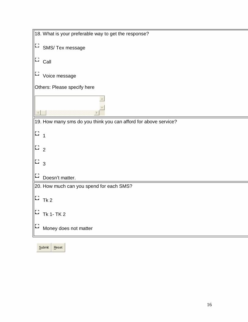
18. What is your preferable way to get the response?
SMS/ Tex message
Call
Voice message
Others: Please specify here
19. How many sms do you think you can afford for above service?
1
2
3
Doesn’t matter.
20. How much can you spend for each SMS?
Tk 2
Tk 1- TK 2
Money does not matter
Submit Reset
17
2.2 Data collection methodology The link of our Questionnaire: www.ulterious.com/thesis_sms We posted this link in:
1. hi5 groups 2. Different Bangladeshi yahoo groups 3. our university’s students groups
We emailed this link to our friends of different fields, relatives etc. We also gave printed version to our university students, friends and relatives.
2.3 Survey results We got total 210 responses for our project both in internet and printed media. We differentiated our results in some different sections which helped us to reach our goals that we made.
18
2.4 Compilation of survey results
A. Problem faced by Customers during gets desired emergency location Among 210 inputs 92% people faced a situation where they need some important addresses urgently and 8% don’t have faced it. We also could know that most of these 92% people faced problems during get their desired location. Fig 2: Problem faced
B. Need of Customers :
Here we tried to find out what actually people need. To get the information about user needs we differentiated the results in some different section, so that we can reach our 2nd goal.
i. Need of emergency services
ii. Preferred Source of Information iii. Preferred method of contacting:
iv. Preferred Ways of Getting Response
v. Address Requirements
45%
25%30%
0%5%
10%15%20%25%30%35%40%45%
Number of People
1
Types of Problems
Didn't get theexact address45%"Address thathe/she got was notupdated 25%Difficult to find theaddress 30%
19
I. Need of Emergency Services
Here we tried to find out what type of services people need incase of emergency. From the result we got that most of the people need hospital/ clinic (70%) in case of emergency. Fig3: Need of Emergency Services
II. Preferred Source of Information Here we tried to find out actually what type of source people feel easy to use at their emergency situations. From the survey result we got that most of the people prefer mobile phone (69%) as their suitable source of getting their desired information.
Fig4: Preferred Source of Information
20%
70%
7%2%0%1%
0%10%20%30%40%50%60%70%
Number Of People
1
Category of Emergency Services
Bank 20%
Hospital/ Clinic70%Hotel 7%
Fire Service 2%
RAB 0%
Police Station 1%
4%12%10%
5%
69%
0%10%20%30%40%50%60%70%
Number of People
1
Sources
News Paper 4%Internet 12%Telephone 10%Yellow Pages 5%Mobile Phone 69%
20
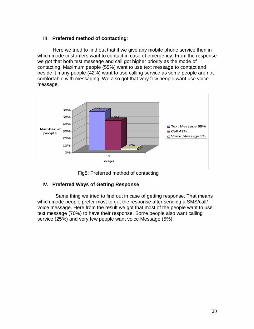
III. Preferred method of contacting:
Here we tried to find out that if we give any mobile phone service then in which mode customers want to contact in case of emergency. From the response we got that both test message and call got higher priority as the mode of contacting. Maximum people (55%) want to use text message to contact and beside it many people (42%) want to use calling service as some people are not comfortable with messaging. We also got that very few people want use voice message.
55%
42%
3%
0%
10%
20%
30%
40%
50%
60%
Number of people
1
ways
Text Message 55%Call 42%Voice Message 3%
Fig5: Preferred method of contacting
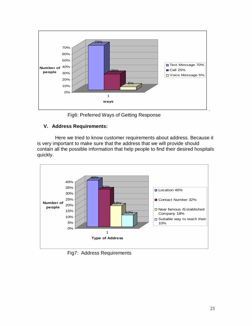
IV. Preferred Ways of Getting Response
Same thing we tried to find out in case of getting response. That means which mode people prefer most to get the response after sending a SMS/call/ voice message. Here from the result we got that most of the people want to use text message (70%) to have their response. Some people also want calling service (25%) and very few people want voice Message (5%).
21
70%
25%
5%
0%
10%
20%
30%
40%
50%
60%
70%
Number of people
1
ways
Text Message 70%Call 25%Voice Message 5%
. Fig6: Preferred Ways of Getting Response
V. Address Requirements:
Here we tried to know customer requirements about address. Because it is very important to make sure that the address that we will provide should contain all the possible information that help people to find their desired hospitals quickly.
40%
32%
18%
10%
0%
5%
10%
15%
20%
25%
30%
35%
40%
Number of people
1
Type of Address
Location 40%
Contact Number 32%
Near famous /EstablishedCompany 18%Suitable way to reach their10%
Fig7: Address Requirements
22
2.5 Conclusions from Survey and possible biases Our main target was to know about customer requirements and we got different type of answers from different people. Analyzing the whole survey result we finally got some important information based on which we started our project. These ares-
• Hospital service is most essential in times of crisis • Mobile phone is the most preferred source of information • SMS based is more convenient
2.6 Solution needed From this survey we got much information about different type of need of different occupation’s people and problems that are facing in their daily life or at any emergency situation. As most of the time hospital service needed by people so a system should be made on hospitals which will
Give the address of nearest hospitals, because at the time of emergency people don’t have time to go far and need the nearest one’s address.
The address should be liked that people can easily find the hospital and the address should be accurate and updated
The service should be user friendly The service should be less expensive
2.7 Our Solutions: We can see that both companies have not thought about the emergency situation and also taking users’ requirements in mind we have designed a system that will be used by a mobile phone operator to provide the subscribers an SMS based service in emergency situations which will be
Based on user needs that we got from our survey Automatically detect the location of the user Provide the names & addresses of the nearest hospitals & Check the availability of ambulance and give the address of those
hospitals which have ambulance.
23
CHAPTER 3: Design of Solution 3.1 Data Collection of Hospitals After doing the survey we took decision that we will make this system for hospitals in Dhaka city. For this at 1st we tried to find out addresses of all hospitals in Dhaka city and we have found 205 hospitals and clinics. To get the name and address of each hospital used directory from book, net and yellow pages. 3.2 Mapping of all hospitals
As we wanted to give the nearest hospital’s address we had to think about the distance of all hospitals from customer’s location. To calculate the distance we need each point of each hospital’s location. As GPS system is not compatible in our country, we tried to find out each point of each hospitals and clinic. For this we plotted all area, sub area and hospitals/clinics under each sub area on map of Dhaka city.
3.3 Simulation of Coordinate System
Divided map into x, y coordinates and found the point of each hospital and clinic’s location
Both x-axis and y-axis are divided into smaller points (0.1, 0.2…) Found out point of each area and sub area of Dhaka city and stored
them in the database
24
Y
0 1 2 3 4 5 6 7 8 9 10 (X, y)= (0, 0) Fig8: Map of Dhaka City Suppose we need to fine out the point of Dhanmondi area. At x axis his area is situated in 2.9 and in the y axis it is situated in 2.7 value. So the point of Dhanmondi will be (x=2.9, y= 2.7). We had applied it for all hospitals in Dhaka city.
25
3.4 Use of Distance Formula We have made our system in such a way that when the server get the message calculates the distance of all hospitals mathematically from the user’s location. For this we have used this Formula: Root over ((XL-XH) 2 + (YL-YH) 2) Where ((XL, YL)) is user’s point from where user give the SMS to server and ( XH,YH) is hospitals’ point. 3.5 Design of Algorithm to find nearest hospital Get the coordinate (XL, YL) of user location x = number of hospitals For x = 1 to 205 Distance = Root over ((XL-XH) 2 + (YL-YH) 2) Save the distances of each hospital in database Dis = 0.1 miles While dis < 3 For x = 1 to 205 If distance < dis then Save the distance into another sheet of database and print them Distance = Distance + 0.1 End if Next x
26
3.6 Design of messaging system
Step 1: User sends the SMS writing his/her query (Hospital/ Amb) to the server (1st SMS from user) Step 2: Server will automatically detect the location of that user that means the server will receive the coordinate (XL, YL) of user’s location. Step 2: The server will start calculating the distance from user’s point (XL,YL) to each stored hospital’s point ( XH,YH) and save these distances in database. Step 3: Server find the hospitals which are in shortest distance from user checking increasing radius from the user’s point (XL,YL). Step 4: Server send name and serial number of nearest hospitals giving the option to choose any of them (1st SMS from server) Step 5: User will choose his/her desired hospital and send the serial number to the server. (2nd SMS from user) Step 6: Finally the server will send the full address of user’s desired hospital.
27
This process work as-
Fig9: Messaging System
Server
Customer
1. SMS (query)
3. SMS (serial number of chosen hospital)
2. SMS (name of hospitals with serial numbers)
4. SMS (Address and location of customer’s desired hospital)
(XL,YL)
Compare the point (XL, YL) with each stored location’s point ( XH,YH)
Find nearest hospitals progressively checking increasing radius from (XL, YL)
Receive the coordinate of the customer
28
CHAPTER 4: Development of Prototype
4.1 Entering of data into sheets
Area:
At 1st we have stored all area name of Dhaka city in this under the “Area
name“ column and given area code number to each area which is unique. These
area codes are stored under “Area code” column beside each area name. Here
we have shown the availability of hospitals in each area which is written by Yes/
No option under the “Availability column”. The point that we have calculated for
each area also be stored in this sheet i.e. x coordinate under “X” column and “Y”
coordinate under Y column
Sub Area:
Each area has sub areas. Some areas are divided into road number and
some are divided into section/ sector number. We have stored sub areas of some
main areas under the “Sub Area” column. Then found out points of each sub
area and stored them in this sheet under “X” and “Y” column.
Hospital:
All the hospitals/clinics’ name have been stored in this sheet under the
“Hos Name” column. We have given each hospital/clinic a code number which is
stored under “Hos/ Clin Code” column. The option (Yes/No) of ambulance
availability of each hospital is given under “Amb Availability” column. We have
also found point for each hospital and put them in this sheet under “X “and “Y”
column. This sheet also contain “area code” column and “Address column”
containing house number/name, road name, road number, sector /section
29
number, postal code and phone number. In this sheet he have given a column
called Distance which stored the distance calculated each time the user send the
SMS to server.
4.2 Design of sheets Area:
Table 1: Area of Dhaka city Area code Area name Availability X Y A001 Agrarian Yes 4.3 11.1 A002 Adabor No 3 10.6 A003 Ahammadbag No 12.6 6.2 A004 Armanitola Yes 9.3 3.9 A005 Azimpur No 6.2 5.2 A006 Badda Yes 10.9 12.8 A007 Bakshi Bazar Yes 7.4 4.4 A008 Banani Yes 8.8 13.1 A009 Banglabazar No 9.8 2.9 A010 Basabo No 11.9 7 A011 Basundhara Yes 11.9 16 A012 Baridhara Yes 10.5 14.3
TextBox1.Text = TextBox1.Text + " Chose ur hos & send SL_No(1,2..3)"
End Sub
Sheet 9: Write
Private Sub CommandButton1_Click()
Row = 2
While Sheet7.Cells(Row, 1) <> ""
If TextBox1.Text = Sheet7.Cells(Row, 1) Then
str1 = Sheet7.Cells(Row, 2)
For ind = 3 To 208
If str1 = Sheet6.Cells(ind, 2) Then
TextBox1.Text = ""
TextBox1.Text = str1 + Sheet6.Cells(ind, 8)
ind = 209
End If
Next ind
End If
Row = Row + 1
36
Wend
End Sub
Private Sub CommandButton2_Click()
Sheet1.Activate
End Sub
Private Sub Worksheet_Activate()
TextBox1.Text = ""
End Sub
4.5 Testing of system with test data
After developing the prototype we have tested it to ensure that our system is
working properly. The point of each area is given to the database and we have
tested our system applying some known points as the user points which is
received by server. In our prototype there is a sheet (Hospital) containing column
called Distance under which distance of each hospital calculated from user point
is stored. So it was easy for us to check which hospitals were within our given
value (0.1 mile) in macro.
For example we wanted to test this for a user who gave the SMS from
Dhanmondi asking for nearest hospitals. We have our prototype in such a way
that the server already knows the point of Dhanmondi which is (6.5, 7.4) and
calculated the distance instantly after getting the SMS from server.
To check that this distance was right, we have calculated each distance by our
selves using calculator and compare with the distance calculated in our
prototype. Then we check actually which distance is shorter and also compare
with those hospitals’ point in Dhanmondi which are got from our prototype.
We did it for all areas and sub areas and those were correct.
37
4.6 Modifications and improvement of prototype
At the beginning of our thesis we had made our prototype in such a way
that user needed to give the location name and query while sending the SMS to
server. Because we did not have thought about distance. We had also made a
sheet for nearest areas of those areas which don’t have any hospitals. We had
found those from map. We were not satisfied with this process because it was
not giving the nearest hospitals’ name accurately. Then we had started to think
how it can be modified. Then we thought about distance and to do it at 1st we
found all points of areas using city map and made it easier for user. Because
now user don’t have to write location name or road number, he/she will just have
to send SMS writing his/her query (Hospital/ Amb ) to server and take the facility
of our system.
4.7 Limitations of prototype
Our goal was to make a system that will help people and we have built a system
that will work but in our country most of the GSM set is not GPS enable so that we can
not implement here as long as the Govt. don’t give us the permission to use the GPS and
GPS enable set publicly.
38
4.8 Screen shots of working prototype with descriptions
Fig14: Sending SMS
This is user’s mobile interface where user has to write his/ her query. In our
prototype we are giving the point of user location but in real life user don’t have
write it, cause server will automatically detect it with the help of tower situated by
different telecom company. Here when the operator press the send button the
server will go to “Hospital” sheet and pick the nearest hospitals. After getting the
nearest hospital it save these hospitals’ name with there serial numbers in
“Nearest Hospitals” sheet.
39
Fig15: Hospital
When the server detect the user’s point then it calculate distance of
each hospital from user’s location and store it temporarily in Distance column of
this sheet. This Distance column’s values will be different for different users.
Now if the user searches by ambulance then a small change occurs. In this case
the server will go to the Ambulance Availability column first and find those
hospitals’ point which has ambulance and then start to find the nearest hospitals
which already have been discussed for query of hospital.
40
Fig16: Nearest hospital
This sheet contains the nearest hospitals and serial number of those
hospital stored temporarily by the server. It is cleared each time the server sends
the address of nearest hospitals to the user.
41
Fig 17: Received SMS Here this interface is showing the nearest hospitals’ name with serial number which given by server and received by user. Server get this
name and serial number from “Nearest Hospitals” sheet. and give user a option to choose his/her desired hospitals.
42
Fig 18: Writing of Serial number
Here user has to write his/ her desired hospital’s serial number and
send. When operator press this send button then “Hospital” sheet again needed
to get the address of that hospital.
43
Fig 19: Receiving SMS
Here it’s just showing the last SMS sent by server which contain
full address of hospital.
44
Chapter 5: Conclusions and future scope
Actually we have designed this system from users’ point of view and tried
to make it user friendly. We future we will try to implement it and accommodate
GPS when it comes. We will also try to include information of different doctors
/specialists and reduce the number of SMS passed by user and server that will
save both time and money. This type of system can be designed for other city
and also for other emergency location like bank/ hotel / police station etc.