March 21, 2011 DISCLAIMER By accessing and using the Alberta Energy website to download or otherwise obtain a scanned mineral assessment report, you (“User”) agree to be bound by the following terms and conditions: a) Each scanned mineral assessment report that is downloaded or otherwise obtained from Alberta Energy is provided “AS IS”, with no warranties or representations of any kind whatsoever from Her Majesty the Queen in Right of Alberta, as represented by the Minister of Energy (“Minister”), expressed or implied, including, but not limited to, no warranties or other representations from the Minister, regarding the content, accuracy, reliability, use or results from the use of or the integrity, completeness, quality or legibility of each such scanned mineral assessment report; b) To the fullest extent permitted by applicable laws, the Minister hereby expressly disclaims, and is released from, liability and responsibility for all warranties and conditions, expressed or implied, in relation to each scanned mineral assessment report shown or displayed on the Alberta Energy website including but not limited to warranties as to the satisfactory quality of or the fitness of the scanned mineral assessment report for a particular purpose and warranties as to the non-infringement or other non-violation of the proprietary rights held by any third party in respect of the scanned mineral assessment report; c) To the fullest extent permitted by applicable law, the Minister, and the Minister’s employees and agents, exclude and disclaim liability to the User for losses and damages of whatsoever nature and howsoever arising including, without limitation, any direct, indirect, special, consequential, punitive or incidental damages, loss of use, loss of data, loss caused by a virus, loss of income or profit, claims of third parties, even if Alberta Energy have been advised of the possibility of such damages or losses, arising out of or in connection with the use of the Alberta Energy website, including the accessing or downloading of the scanned mineral assessment report and the use for any purpose of the scanned mineral assessment report so downloaded or retrieved. d) User agrees to indemnify and hold harmless the Minister, and the Minister’s employees and agents against and from any and all third party claims, losses, liabilities, demands, actions or proceedings related to the downloading, distribution, transmissions, storage, redistribution, reproduction or exploitation of each scanned mineral assessment report obtained by the User from Alberta Energy.
Transcript
March 21, 2011
DISCLAIMER By accessing and using the Alberta Energy website to download or otherwise obtain a scanned mineral assessment report, you (“User”) agree to be bound by the following terms and conditions:
a) Each scanned mineral assessment report that is downloaded or otherwise
obtained from Alberta Energy is provided “AS IS”, with no warranties or representations of any kind whatsoever from Her Majesty the Queen in Right of Alberta, as represented by the Minister of Energy (“Minister”), expressed or implied, including, but not limited to, no warranties or other representations from the Minister, regarding the content, accuracy, reliability, use or results from the use of or the integrity, completeness, quality or legibility of each such scanned mineral assessment report;
b) To the fullest extent permitted by applicable laws, the Minister hereby
expressly disclaims, and is released from, liability and responsibility for all warranties and conditions, expressed or implied, in relation to each scanned mineral assessment report shown or displayed on the Alberta Energy website including but not limited to warranties as to the satisfactory quality of or the fitness of the scanned mineral assessment report for a particular purpose and warranties as to the non-infringement or other non-violation of the proprietary rights held by any third party in respect of the scanned mineral assessment report;
c) To the fullest extent permitted by applicable law, the Minister, and the
Minister’s employees and agents, exclude and disclaim liability to the User for losses and damages of whatsoever nature and howsoever arising including, without limitation, any direct, indirect, special, consequential, punitive or incidental damages, loss of use, loss of data, loss caused by a virus, loss of income or profit, claims of third parties, even if Alberta Energy have been advised of the possibility of such damages or losses, arising out of or in connection with the use of the Alberta Energy website, including the accessing or downloading of the scanned mineral assessment report and the use for any purpose of the scanned mineral assessment report so downloaded or retrieved.
d) User agrees to indemnify and hold harmless the Minister, and the Minister’s
employees and agents against and from any and all third party claims, losses, liabilities, demands, actions or proceedings related to the downloading, distribution, transmissions, storage, redistribution, reproduction or exploitation of each scanned mineral assessment report obtained by the User from Alberta Energy.
--··'·
?EAMiT 'TO PRACTK;E Dahrouge Geologi ltd. (762137 Alberta Ltd.)
Signature -fl~~:::::~ry..-Date ~cc C(:;;O
PERMIT NUMBER: P 6793 The Association of Professional Engineers,
Geologists and Geophysicists of Alberta
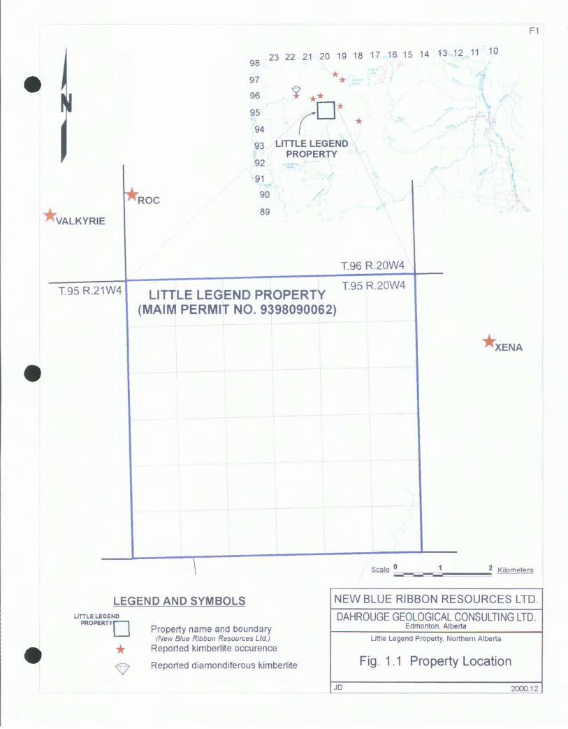
NEW BLUE RIBBON RESOURCES LTD. AND GRIZZLY GOLD INC.
ASSESSMENT REPORT LITTLE LEGEND PROPERTY
NORTHEASTERN ALBERTA
Metallic and Industrial Minerals Permit 9398090062
Table 1.1 Property Description and Location of the Little Legend MAIM Permit .......... . Table 1.2 Statement of Expenditures ......................................................................... . Table 1.3 Lands Retained .............................. : ........................................................... . Table 1.4 Allocation of Expenditures .......................................................................... .
1 1 3 3 3
4
4 4 5
5
9 9 10 11
12
1 2 3 3
Table 5.1 Summary of Ground Magnetic Targets ... ........... .... ... ..... .. ...... .. . ......... .. . . .. .. .. 1 O
Fig. 1.1
Fig. 5.1 Fig. 5.2 Fig. 5.3 Fig. 5.4 Fig. 5.5
LIST OF ILLUSTRATIONS
Property Location and Metallic and Industrial Minerals Permit 9398090062 ................................................................................... .
Aeromagnetic Anomalies and Total Magnetic Field. ·······················'······· Grizz Grid Ground Magnetic Survey, Total Magnetic Field .................... . Pooh Grid Ground Magnetic Survey, Total Magnetic Field .................... . Care Grid Ground Magnetic Survey, Total Magnetic Field ..................... . Yogi Grid Ground Magnetic Survey, Total Magnetic Field ..................... .
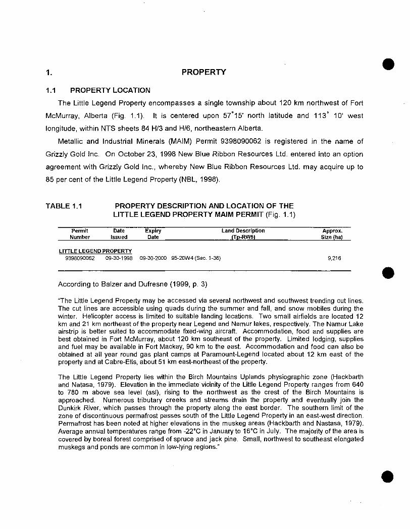
"The Little Legend Property may be accessed via several northwest and southwest trending cut lines. The cut lines are accessible using quads during the summer and fall, and snow mobiles during the winter. Helicopter access is limited to suitable landing locations. Two small airfields are located 12 km and 21 km northeast of the property near Legend and Namur lakes, respectively. The Namur Lake airstrip is better suited to accommodate fixed-wing aircraft. Accommodation, food and supplies are best obtained in Fort McMurray, about 120 km southeast of the property. Limited lodging, supplies and fuel may be available in Fort Mackay, 90 km to the east. Accommodation and food can also be obtained at all year round gas plant camps at Paramount-Legend located about 12 km east of the property and at Cabre-Ells, about 51 km east-northeast of the property.
The Little Legend Property lies within the Birch Mountains Uplands physiographic zone (Hackbarth and Natasa, 1979). Elevation in the immediate vicinity of the Little Legend Property ranges from 640 to 780 m above sea level (asl), rising to the northwest as the crest of the Birch Mountains is approached. Numerous tributary creeks and streams drain the property and eventually join the Dunkirk River, which passes through the property along the east border. The southern limit of the . zone of discontinuous permafrost passes south of the Little Legend Property in an east-west direction. Permafrost has been noted at higher elevations in the muskeg areas (Hackbarth and Nastasa, 1979). Average annual temperatures range from -22°C in January to 16°C in July. The majority of the area is covered by boreal forest comprised of spruce and jack pine. Small, northwest to southeast elongated muskegs and ponds are common in low-lying regions."
4
2. INTRODUCTION
During 1998 to early 2000, New Blue Ribbon Resources Ltd. (NBL) conducted exploration at
the Little Legend Property for primary diamond deposits. Exploration activities included the
acquisition and review of high-resolution aeromagnetic data (HRAM), and ground
magnetometer surveys. Several sites were permitted for drilling and a drill rig mobilized to the
area during the early part of 2000. The lack of a high-quality magnetic target, based upon
ground geophysics, prevented drilling during the term of the issued exploration permit.~
This assessment report describes exploration conducted on the Little Legend Property and
is based on publically available information and work conducted by Dahrouge Geological
Consulting Ltd. It has been prepared at the request of Larry Kryska, president of NBL.
3. SUMMARY
3.1 SUMMARY
Within the central parts of the Legend Kimberlite Cluster, the MAIM Permit which constitutes
the Little Legend Property was explored for primary diamond deposits.
During the spring of 1998, Spectra Exploration Geoscience Corp. (Spectra) conducted a
high-resolution aeromagnetic survey, on behalf of Montello Resources Ltd. (Montello) and
Redwood Resources Ltd., on the surrounding Legend Property. During the later part of 1998,
NBL acquired approximately 600 line-km of aeromagnetic data from Montello, which covered
the Little Legend Property. The aeromagnetic data was levelled by Spectra for NBL, and
subsequently reviewed by Dahrouge Geological Consulting Ltd. and by Apex Geoscience Ltd.
During the later part of 1999 and the early part of 2000, field work was conducted by
Dahrouge Geological Consulting Ltd. This work included four ground geophysical grids,
permitting for diamond drilling, and the mobilization of a diamond drill rig to the area. The four
ground geophysical surveys failed to identify a distinct geophysical target characteristic of
kimberlite. A high-priority target within the southwest part of the property was not examined due
to poor access.
5
3.2 RECOMMENDATIONS
Although the ground geophysics conducted to date has failed to define a distinct
geophysical target characteristic of kimberlite, at least two high-priority (Table 5.1: 4 and 7) and
numerous medium- to low-priority targets remain. The remaining high- and low-priority targets
should be examined by means of ground geophysical (magnetometer) surveys. If any of the
targets produces a geophysical signature characteristic of kimberlite, they should be drill tested.
4. REGIONAL GEOLOGY
Balzer and Dufresne (1999, p. 5 to 12) provide the following, exhaustive description of
regional geologic setting;
"Precambrian
The Little Legend Property lies near the eastern edge of the Western Canadian Sedimentary basin within the northern segments of the Peace River Arch (PRA). However, Precambrian rocks are not exposed within the Namur Lake region (NTS 84H). The basement underlying the PRA is comprised of several terranes including the Buffalo Head and the Chinchaga, both of which were accreted between 1.8 and 2.4 billion years (Ga) ago and collectively form the Buffalo Head Craton (Ross et al., 1991, 1998). Due to their relatively stable history since accretion, the Buffalo Head and Chinchaga terranes are currently the focus of extensive diamond exploration in northern Alberta.
The basement underlying the Little Legend Property borders the Buffalo Head Terrane and has been interpreted to be part of the Talston Magmatic Zone (Figure 2). The Taltson Magmatic Zone (TMZ) is a 2.0 to 1.8 Ga aged terrane that represents a magmatic arc related to collisional orogeny during the Proterozoic. It is unclear whether the TMZ represents a deep-seated thermal welt between two distinct protocontinents or a discreet thin-skinned thrust slice that has been emplaced over the top of the basement of the Rae Subprovince, as has been proposed for the Trans-Hudson orogenic belt in Saskatchewan (Hajnal et al., 1993). The TMZ is characterised by a highly corrugated internal fabric comprised of extremely high relief, north to northwest trending sinuous magnetic anomalies. The Little Legend property is underlain by the western portion of the TMZ with much lower magnetic relief and a somewhat indistinct magnetic pattern relative to typical TMZ terrane. Villeneuve et al. (1993) indicate that the western boundary of the TMZ is not obvious based upon geophysical data and has been placed using zircon ages from a couple of basement drill cores. The basement beneath the Little Legend property may belong to the eastern "Utikuma Belt" of the BHT as the western portion of the TMZ. The BHT is an area of high positive magnetic relief with a north to northeasterly fabric (Villeneuve et al., 1993). Ashton Mining of Canada lnc.'s (Ashton) diamondiferous kimberlites are underlain by basement of the BHT. Part of the Churchill Structural Province (Rae Subprovince), the BHT may represent either Archean crust that has been thermally reworked during the Hudsonian (Proterozoic) Orogeny (Burwash et al., 1962; Burwash and Culbert, 1976; Burwash et al., 1994) or an accreted Proterozoic terrane that may or may not have an Archean component (Ross and Stephenson, 1989; Ross et al., 1991; Villeneuve et al., 1993). Precambrian rocks intersected in drill core from the BHT comprise felsic to intermediate metaplutonic rocks, felsic metavolcanic rocks and high-grade gneisses (Villeneuve et al., 1993). The presence of numerous eclogitic garnets, eclogitic pyroxenes and chromium-bearing corundums in association with kimberlites or related intrusions in northern Alberta may indicate the presence of a significant volume of accreted and subducted oceanic
6
basalt and sedimentary protolith in the lower crust and/or upper mantle beneath the BHT. Seismic refraction and reflection studies indicate that the crust in the Namur Lake region is likely between 35 to 40 km thick, a trait favourable for the formation and preservation of diamonds in the upper mantle (Dufresne et al., 1996).
Phanerozoic
Overlying the basement in the Namur Lake region is a thick sequence of Phanerozoic rocks comprised mainly of Cretaceous sandstones and shales near surface and Mississippian to Devonian carbonates and salts at depth (Glass, 1990). Bedrock exposure within the permit block is limited primarily to river and stream cuts and topographic highs. Table 2 shows the upper units found in the region. Further information pertaining to the distribution and character of these and older units can be obtained from well log data in government databases and various geological and hydrogeological reports (Green et al., 1970; Hackbarth and Nastasa, 1979; Glass, 1990; Mossop and Shetson, 1994).
TABLE 2 GENERALIZED STRATIGRAPHY NAMUR LAKE AREA
SYSTEM GROUP FORMATION AGE* DOMINANT LITHOLOGY
(MA) PLEISTOCENE Recent Glacial till and associated sediments TERTIARY 6.5 to Preglacial sand and gravels
Recent UPPER Lea Park 80 to 83 Bioturbated silty-shale CRETACEOUS
Smoky Kaskapau 88 to 92 Shale, silty-shale and ironstone; includes the Second White Specks unit
Dunveoan 92 to 95 Sandstone and siltstone
Fort St. John Shaftesbury 95 to 98 Shale, bentonites, Fish-Scale Member LOWER Colorado Pelican 98 to Glauconitic sands, siltstone, mudstone CRETACEOUS 100 and conglomerate
Joli Fou 100 to Shale, glauconitic sandstone and 103 bentonite
*Ages approximated from Green et al. (1970), Glass (1990), Dufresne et al. (1996) and Leckie et al. (1997).
Underlying the near surface Cretaceous units in the Namur Lake area is a thick succession of Devonian to Mississippian carbonates, calcareous shales and salt horizons (Mossop and Shetson, 1994). Several of the Devonian carbonate units are part of the Grosmont Reef Complex, a large structure that extends in a northwesterly direction from east of Lesser Slave Lake to the N.W.T. (Bloy and Hadley, 1989). The Grosmont Reef Complex is likely the result of tectonic uplift along this trend during the Devonian. This structure, in conjunction with the PRA, may have played a significant role in the localisation of faults and other structures that could have provided favourable pathways for kimberlite volcanism.
In general, the Cretaceous strata underlying the Little Legend Property is composed of alternating units of marine and nonmarine sandstones, shales, siltstones, mudstones and bentonites. The oldest documented units exposed in the vicinity of the permit area belong to the Smoky Group, a sequence of Upper Cretaceous, calcareous and noncalcareous shales (Figure 3). However, older units from the base of the Fort St. John and/or the top of the Colorado groups, such as the Shaftesbury Formation, may be exposed in river and stream cuts.
7
The Colorado Group is Lower Cretaceous in age and contains numerous formations, including the Joli Fou and the Pelican, which are correlative with the Peace River Formation of the Fort St. John Group further west (Dufresne et al., 1996). The Joli Fou Formation is comprised of shale with interbedded, bioturbated to glauconitic sandstones and minor amounts of bentonite, pelecypod coquinas, nodular phosphorite and concretionary layers of calcite, siderite and pyrite (Glass, 1990). The Pelican Formation disconformably overlies the Joli Fou Formation and is gradational with the overlying Shaftesbury Formation (shales of the Colorado Group). The Pelican Formation is comprised of glauconitic sands, interbedded siltstone and mudstone with minor amounts of conglomerate. Coalified plant fragments and bioturbated sandstones are locally abundant.
The Shaftesbury Formation is lower Upper Cretaceous in age and is comprised of marine shales with fish-scale bearing silts, thin bentonitic streaks and ironstones. The upper contact is conformable and transitional with the Dunvegan Formation, where the Dunvegan Formation is present. The Shaftesbury Formation may be exposed along river and stream cuts. Evidence of extensive volcanism during deposition of the Shaftesbury Formation exists in the form of numerous bentonitic horizons throughout the formation, especially within and near the Fish Scales horizon (Leckie et al., 1992; Bloch et al., 1993). The deposition of the Shaftesbury Formation is also chronologically correlative with the deposition of the Crowsnest Formation volcanics of southwest Alberta (Olson et al., 1994; Dufresne et al., 1995) and with kimberlitic volcanism near Fort B la Corne in Saskatchewan (Lehnert -Thiel et al., 1992; Scott Smith et al., 1994)
Deltaic to marine, feldspathic sandstones, silty shales and laminated carbonaceous siltstones, characterise the Dunvegan Formation. The Dunvegan Formation in the Birch Mountains region is shaley, thin and often discontinuous. As a result, it may or may not be present within the Namur Lake area. Where present, the unit is conformably overlain by shales of the Kaskapau Formation of the Smoky Group. It should be noted that the Ashton pipes exist just above or near the contact between the Kaskapau and the Dunvegan formations (Dufresne et al., 1998).
The LaBiche Formation is a frequently incorrectly used term correlative to units of the Shaftesbury Formation and other formations within the Smoky and Colorado groups (Glass, 1990). In the Namur Lake area, the LaBiche Formation is equivalent to the Smoky Group and Lea Park Formation. The Smoky Group is Upper Cretaceous in age and is comprised of thinly bedded, marine, silty shale with occasional ironstone and claystone nodules and thin bentonite streaks. The group is divided into three formations: (a) a lower shale unit, Kaskapau, which includes the Second White Specks marker unit (SWS); (b) a middle sandstone, named the Bad Heart; and, (c) an upper shale, Puskwaskau, which contains the First White Specks marker unit. Bedrock exposures in the Little Legend Property are likely comprised of the Kaskapau Formation, in particular, the SWS or lower, since most of the upper portions of the Smoky Group have been eroded away during tectonic uplift, possibly associated with uplift of the PRA. The Kaskapau Formation contains abundant ammonite fossils and concretions. In addition, foraminifera are present in the lower arenaceous units (Glass, 1990). Exposures of the Smoky Group are generally limited to river and stream cuts, topographic highs, and regions with thin drift veneer. In the Namur Lake region, the SWS is unconformably overlain by the Lea Park Formation. The top of the SWS also culminates with evidence of a significant increase in volcanism, based on the volume and number of bentonite units in the vicinity. It is conceivable that this volcanism may have been in conjunction with or a prelude to gradual uplift and non-deposition of the missing Smoky Group formations. There is strong evidence of volcanism associated within the depositional time span of the Smoky Group in the vicinity of the PRA (Auston, 1998; Carlson et al., 1998). Ashton's recently discovered Buffalo Head Hills kimberlites yield emplacement ages of 86 to 88 Ma (Auston, 1998; Carlson et al., 1998). In addition, recently discovered kimberlites in the Birch Mountains by Kennecott Canada Exploration Inc. (Kennecott) in a joint venture with Montello Resources Ltd. (Montello) and Redwood Resources Inc. (Redwood) are reported to yield emplacement ages of about 82 Ma (Northern Miner, 1998).
8
The youngest bedrock unit in the Namur Lake area is the Lea Park Formation of Upper Cretaceous age. Marine in origin, the Lea Park Formation is comprised of light grey shale and pale grey, glauconitic, silty-shale with ironstone concretions. Preliminary micropaleontology conducted by the Geological Survey of Canada (GSC) on drill cores from the Birch mountains area indicates a time gap of 4 to 8 million years between the Lea Park Formation and the top of the underlying SWS Formation. This time gap, combined with the evidence of regolithic material incorporated in the lag deposit capping the SWS in boreholes situated to the east, indicates that significant uplift and erosion may have occurred between the end of the SWS and the deposition of the overlying Lea Park shales and siltstones (Dufresne et al., In Preparation).
Quaternary
Data and information about the surficial geology in central to northern Alberta is sparse and regional in nature. Prior to continental glaciation during the Pleistocene, most of Alberta, including the Namur Lake region, had reached a mature stage of erosion. Large, broad paleochannels and their tributaries drained much of the region, flowing in an east to northeasterly direction (Dufresne et al., 1996). In addition, fluvial sand and gravel was deposited preglacially in these channels.
During the Pleistocene, multiple southwesterly and southerly glacial advances of the Laurentide Ice Sheet across the region resulted in the deposition of ground moraine and associated sediments (Figure 5 in Dufresne et al., 1996). The advance of glacial ice may have resulted in the erosion of the underlying substrate and modification of bedrock topography. Dominant ice flow directions within the Little Legend Property appear to be topographically controlled, following the southwest trend of the Birch Mountains. In addition, topographic variations may have locally channelled ice flow towards the south to south-southeast. Glacial sediments infilled low-lying and depressional areas, draped topographic highs and covered much of the Namur Lake area as veneers and/or blankets of till and diamict. Localised pockets of deposits from glacial meltwater and proglacial lakes likely infilled areas of low relief.
Glacial ice is believed to have receded from the area between 15,000 and 10,000 years ago. After the final glacial retreat, lacustrine clays and silts were deposited in low-lying regions along with organic sediments. Rivers previously re-routed due to glaciation, re-established easterly to northeasterly drainage regimes similar to that of the pre-Pleistocene. Extensive colluvial and alluvial sediments accompanied post-glacial river and stream incision.
The majority of the Little Legend Property is covered by drift of variable thickness, ranging from 45 m to likely over 150 m (Pawlowicz and Fenton, 1995a,b). Drilling by Kennecott on the adjacent Legend Property intersected drift ranging from approximately 120 m northwest and west of the Little Legend Property to over 80 m just east of Blue Ribbon's property (Montello Resources Ltd., 1998a,b). Drift thickness may be thinner locally, in areas of higher topographic relief. As an example, one of the kimberlites drilled by Kennecott was intersected beneath only 12.2 m of overburden. Unfortunately, local drift thickness for the Little Legend property can not be easily delineated due to the sparsity of publicly available data for the region. Limited general information regarding bedrock topography and drift thickness in northern Alberta is available from the logs of holes drilled for petroleum, coal or groundwater exploration and from regional government compilations (Mossop and Shetson, 1994; Pawlowicz and Fenton, 1995a,b; Dufresne et al., 1996).
Structural Geology
In north-central Alberta, the PRA is a region where the younger Phanerozoic rocks, which overlie the Precambrian basement, have undergone periodic vertical and, possibly, compressive deformation from the Proterozoic into Tertiary time (Cant, 1988; O'Connell et al., 1990; Dufresne et al., 1995, 1996). This pattern of long-lived, periodic uplift and subsidence has imposed a structural control on
9
the deposition patterns of the Phanerozoic strata in northern Alberta. In addition, this periodic movement has resulted in a rectilinear pattern of faults that not only is responsible for structurally controlled oil and gas pools, but may have provided potential pathways for later deep-seated intrusive kimberlitic magmas.
During the mid-Cretaceous and Early Tertiary, compressive deformation occurred as a result of the orogenic event that eventually led to the formation of the Rocky Mountains. The PRA was emergent during this period resulting in the reactivation of many prominent basement faults. The Phanerozoic rocks beneath the Little Legend Property lie along the northeastern edge of the axis of the PRA and are underlain by and proximal to basement faults related to the Grosmont Reef Complex, which formed over the Grosmont High (Blay and Hadley, 1989; Dufresne et al., 1996). There is strong evidence that basement faults that have manifested themselves in the overlying Phanerozoic sedimentary succession may have controlled the emplacement of the Mountain Lake Kimberlite and the Buffalo Head Hills kimberlites west of the Little Legend Property (Dufresne et al., 1996; Leckie et al., 1997). It is unclear whether the kimberlites discovered to date in the Birch Mountains by Kennecott and its joint venture partners surrounding Blue Ribbon's Little Legend Property show any spatial relationship to structures in the underlying basement and/or Phanerozoic succession. However, structures observed on the Little Legend Property resulting from tectonic activity associated with movement along the PRA, the Grosmont High, or even along contacts between different basement terranes could be pathways for kimberlitic volcanism."
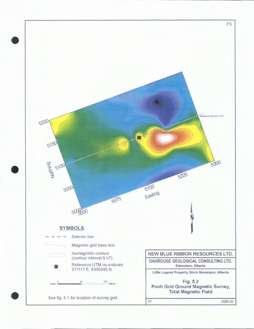
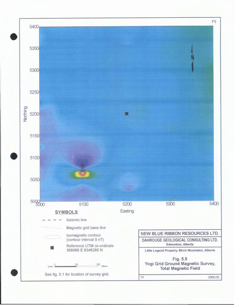
5. EXPLORATION
5.1 AIRBORNE GEOPHYSICAL SURVEY
During the spring of 1998, Spectra Geoscience Corp. (Spectra) conducted a high-resolution
aeromagnetic survey, on behalf of Montello Resources Ltd. (Montello) and Redwood Resources
Ltd., on the surrounding Legend Property. The survey was conducted at about 100 m above
ground level, with 200-m spaced east-west flight lines and 1,000 to 1,200-m spaced north-south
ties lines. During the later part of 1998, NBL acquired approximately 600 line-km of
aeromagnetic data from Montello, for the Little Legend Property. The aeromagnetic data was
levelled by Spectra for NBL, and subsequently reviewed by Dahrouge Geological Consulting
Ltd. and by Apex Geoscience Ltd. (Fig. 5.1).
Based upon a review of the flight line profiles, Apex Geoscience Ltd. identified a total 116
prospective high-frequency magnetic anomalies. Of the 116 anomalies, 78 were within the
boundaries of the Little Legend Property (Appendix 1). Several medium- to high-priority targets
not associated with drainage or culture were recommended for ground geophysical surveys.
10
5.2 GROUND MAGNETOMETER SURVEY
During the later part of 1999 and early part of 2000, Dahrouge Geological Consulting Ltd.
selected nine targets for ground geophysical surveys (Fig. 5.1 and Table 5.1). Due to time
limitations and ground access, only four targets (Care, Grizz, Pooh and Yogi) were gridded and
surveyed, as follows:
TABLE 5.1
I
SUMMARY OF GROUND MAGNETIC TARGETS
Target UTM Coordinates (NAO 83) Ground Number Easting Northing Geophysics
1. Grizz (80) 369,720 6,350,000 Yes 2. Pooh (72) 371,050 6,350,440 Yes 3. Care ( - ) 371,700 6,350,550 Yes 4. (41 or 44) 366,680 6,344,340 No 5. (73) 369~880 6,345,420 No 6. (52) 365,790 6,343,240 No 7. (49) 365,150 6,343,550 No 8. Yogi ( - ) 368,040 6,348,460 Yes 9. ( 33) 368,555 6,345,604 No (1) Number in brackets corresponds to geophysical target of Balzer and "' Dufresne (1999; Appendix 1 ).
For each target, after a baseline was surveyed on a particular grid, grid cross-lines were
established at 100 m intervals and on each cross-line, stations were chained by topofil and
marked with flagging at 25 m intervals. At 12% m stations along each cross-line, a
magnetometer reading was collected using a GEM System GSM-19 integrated Overhauser
effect proton precession magnetometer. The magnetic readings were corrected for terrestrial
field magnetic variation using a stationary GSM-19 base-station. The corrected magnetometer
data was processed, gridded, contoured, and used to generate Figures 5.2 through 5.5.
11
5.3 DIAMOND DRILLING
During the later part of 1999 and early 2000, Lorrnel Consultants Ltd. obtained drill permits
on behalf of NBL for the nine target locations defined in Table 5.1. In anticipation of the
proposed program, Aggressive Diamond Drilling Ltd. of Kelowna, B.C. mobilized a drill rig and
associated supplies to the Paramount-Legend Camp, located about 12 km east-southeast of the
property. Unfortunately, drilling had to be delayed for an additional season for the following
reasons:
1) lack of available accommodations for the drill crew at the Paramount-Legend Camp,
2) poor-quality of ground geophysical targets surveyed to date; and
3) early spring break-up and March expiry of drill permits.
Edmonton, Alberta
2000 12 29
12
6. REFERENCES
Balzer, S.A. and Dufresne, M.B. (1999) Qualifying Report, Little Legend Property, Northern
Alberta; Prepared for New Blue Ribbon Resources Ltd. by Apex Geoscience Ltd.,
March 1999; 24 p., 9 fig., 2 appendices.
Bloch, J., Schroder-Adams, C., Leckie, D.A., Mcintyre, D.J., Craig, J. and Staniland, M. (1993). Revised stratigraphy of the Lower Colorado Group (Albian to Turonian), Western Canada; Bulletin of Canadian Petroleum Geology, vol. 41, no. 3, pp. 325-348.
Blay, G.R. and Hadley, M.G. (1989). The development of porosity in carbonate reservoirs. Canadian Society of Petroleum Geologists, Continuing education Short Course.
Burwash, R.A., Baadsgaard, H., and Peterman, Z.E. (1962). Precambrian K- Ar dates from the western Canada Sedimentary Basin. Journal of Geophysical Research, 67, pp. 1617-1625.
Burwash, R.A. and Culbert, R.R. (1976). Multivariate geochemical and mineral patterns in the Precambrian basement of Western Canada. Tectonophysics. vol. 20, pp. 193-201.
Burwash, R.A., McGregor, C.R. and Wilson, J.A. (1994). Precambrian basement beneath the
Western Canada Sedimentary Basin; In G.D. Mossop and I. Shetsen (eds.), Geological Atlas of the Western Canada Sedimentary Basin, published jointly by the Canadian Society of Petroleum Geologists and the Alberta Research Council, Ch. 5, pp. 49-56.
Cant, D.J. (1988). Regional structure and development of the Peace River Arch, Alberta: A Paleozoic failed-rift system?; Bulletin of Canadian Petroleum Geology, 36:284-295.
Dufresne, M.B., Eccles, D.R., McKinstry, B., Schmitt, D.R., Fenton, M.M., Pawlowicz, J.G. and Edwards, W.A.D. (1996). The Diamond Potential of Alberta; Alberta Geological Survey, Bulletin No. 63, 158 pp.
Glass, D.J. (1990). Lexicon of Canadian Stratigraphy, Volume 4. Western Canada, including Eastern British Columbia, Alberta, Saskatchewan and Southern Manitoba; Canadian Society of Petroleum Geologists.
Green, R., Mellon, G.B. and Carrigy, M.A. (1970). Bedrock Geology of Northern Alberta. Alberta Research Council, Unnumbered Map (scale 1 :500,000).
Hackbarth, D.A. and Natas, N. (1979) The hydrogeology of the Athabasca oil sands area, Alberta; Alta. Res. Council, Bull. No. 38.
13
Hajnal, Z., Green, A., White, Cloves, R., Lewry, J. and Luces, S. (1993). Seismic signature of the Trans-Hudson Orogene. In GAC-MAC Joint Annual Meeting, May 17-19, Edmonton, Alberta, unpublished Program with Abstracts, p. A-38.
Leckie, D.A., Kjarsgaard, B.A., Peirce, J.W., Grist, A.M., Collins, M., Sweet, A., Stasiuk, L., Tomica, M.A., Eccles, R., Dufresne, M.B., Fenton, M.M., Pawlowicz, J.G., Balzer, S.A., Mcintyre, D.J. and McNeil, D.H. (1997). Geology of a Late Cretaceous Possible Kimberlite at Mountain Lake, Alberta - Chemistry, Petrology, Indicator Minerals, Aeromagnetic Signature, Age, Stratigraphic Position and Setting; Geol. Surv. Can., Open File 3441, 202 p.
New Blue Ribbon Resources Ltd. (1998) Property Acquision Near Recent Kimberlite Discoveries In Alberta; corporate press release dated Monday, October 26, 1998.
O'Connell, S.C., Dix, G.R. and Barclay, J.E. (1990). The origin, history and regional structural development of the Peace River Arch, Western Canada; Bulletin of Canadian Petroleum Geology, 38A:4-24.
Ross, G.M. and Stephenson, R.A. (1989). Crystalline Basement: The Foundation of Western Canada Sedimentary Basin; In B.D. Ricketts (ed.) Western Canada Sedimentary Basin, A Case History; Canadian Society of Petroleum Geologists, Calgary, Alberta, pp. 33-45.
Ross, G.M., Parrish, R.R., Villeneuve, M.E. and Bowring, S.A. (1991). Geophysics and geochronology of the crystalline basement of the Alberta Basin, western Canada; Canadian Journal of Earth Sciences, vol. 28, pp. 512-522.
Ross, G.M., Theriault, R. and Villeneuve, M. (1998). Buffalo Head Terrane and Buffalo Head Craton; What's the difference and does it matter?; Calgary Mineral Exploration Group, 7th Annual Calgary Mining Forum, p. 19-20.
Villeneuve, M.E., Ross, G.M., Theriault, R.J., Miles, W., Parrish, R.R., and Broome, J. (1993) Tectonic Subdivision and U-Pb Geochronology of the Crystalline Basement of the Alberta Basin, Western Canada; Geological Survey of Canada Bulletin 447, 86 p.
23 22 21 20 19 18 17 16 15 14 13 12 11 10 98
97 ** 96 ~ ** 95 D* l. ( * 94
\
93 LITTLE LEGEND PROPERTY
92
91
F1
t
~
f*ROC 90
VALKYRIE
T.95 R.21W4
89
LITTLE LEGEND PROPERTY (MAIM PERMIT NO. 9398090062)
\
T.96 R.20W4
T.95 R.20W4
* XENA
Scale O 1 ;;;;;,---__ ___
2 Kilometers
LEGEND AND SYMBOLS NEW BLUE RIBBON RESOURCES LTD. LITTLE LEGEND
PROPERTYD
* v
Property name and boundary (New Blue Ribbon Resources Ltd.)
Reported kimberlite occurence
Reported diamondiferous kimberlite
DAHROUGE GEOLOGICAL CONSULTING LTD. Edmonton. Alberta
Little Legend Property, Northern Alberta
Fig. 1.1 Property Location
JD 2000.12
•
SYMBOLS
Seismic line
Magnetic grid base line
lsomagnetic contour (contour interval 5 nT)
Reference UTM co-ordinate 369815 E 6349715 N
Scalf' o ____ ,oo
See fig . 5.1 for location of survey grid.
F2
NEW BLUE RIBBON RESOURCES LTD.
DAHROUGE GEOLOGICAL CONSULTING LTD.
TF
Edmonton, Alberta
Little Legend Property, Birch Mountains, Alberta
Fig. 5.2 Grizz Grid Ground Magnetic Survey,
Total Magnetic Field
2000.09
• 0
SYMBOLS
Seismic line
Magnetic grid base line
lsomagnetic contour (contour interval 5 nT)
Reference UTM co-ordinate 371117 E 6350245 N
100 Scae ---- M!C!e&
See fig . 5.1 for location of survey grid.
F3
NEW BLUE RIBBON RESOURCES LTD.
DAHROUGE GEOLOGICAL CONSULTING LTD.
TF
Edmonton, Alberta
Little Legend Property, Birch Mountains, Alberta
Fig. 5.3 Pooh Grid Ground Magnetic Survey,
Total Magnetic Field
2000.02
•
SYMBOLS
Se1sm1c line
Magnetic grid base line
lsomagnetic contour (contour interval 5 nT)
Reference UTM co-ordinate 371857 E 6350305 N
Scae o ____ ,oo 2!Xl - ~
See fig . 5.1 for location of survey grid.
Easting
F4
NEW BLUE RIBBON RESOURCES LTD.
DAHROUGE GEOLOGICAL CONSULTING LTD.
TF
Edmonton, Alberta
Little Legend Property, Birch Mountains, Alberta
Fig. 5.4 Care Grid Ground Magnetic Survey,
Total Magnetic Field
2000.02
•
SYMBOLS
Seismic line
Magnetic grid base line
lsomagnetic contour (contour interval 5 nn
Reference UTM co-ordinate 368066 E 6348285 N
Saie o _____ ,oo
See fig . 5.1 for location of survey grid.
F5
NEW BLUE RIBBON RESOURCES LTD.
DAHROUGE GEOLOGICAL CONSULTING LTD.
TF
Edmonton. Alberta
Little Legend Property, Birch Mountains, Alberta
Fig. 5.5 Yogi Grid Ground Magnetic Survey,
Total Magnetic Field
2000.02
A1
APPENDIX 1: AEROMAGNETIC ANOMALIES
Note: All aeromagnetic anomalies as selected by Balzer and Dufresne (1999) UTM co-ordinates are NAO 27
Anomaly Line Fiducial UTM Approximate Number Easting Northing Magnetic Intensity (nT)
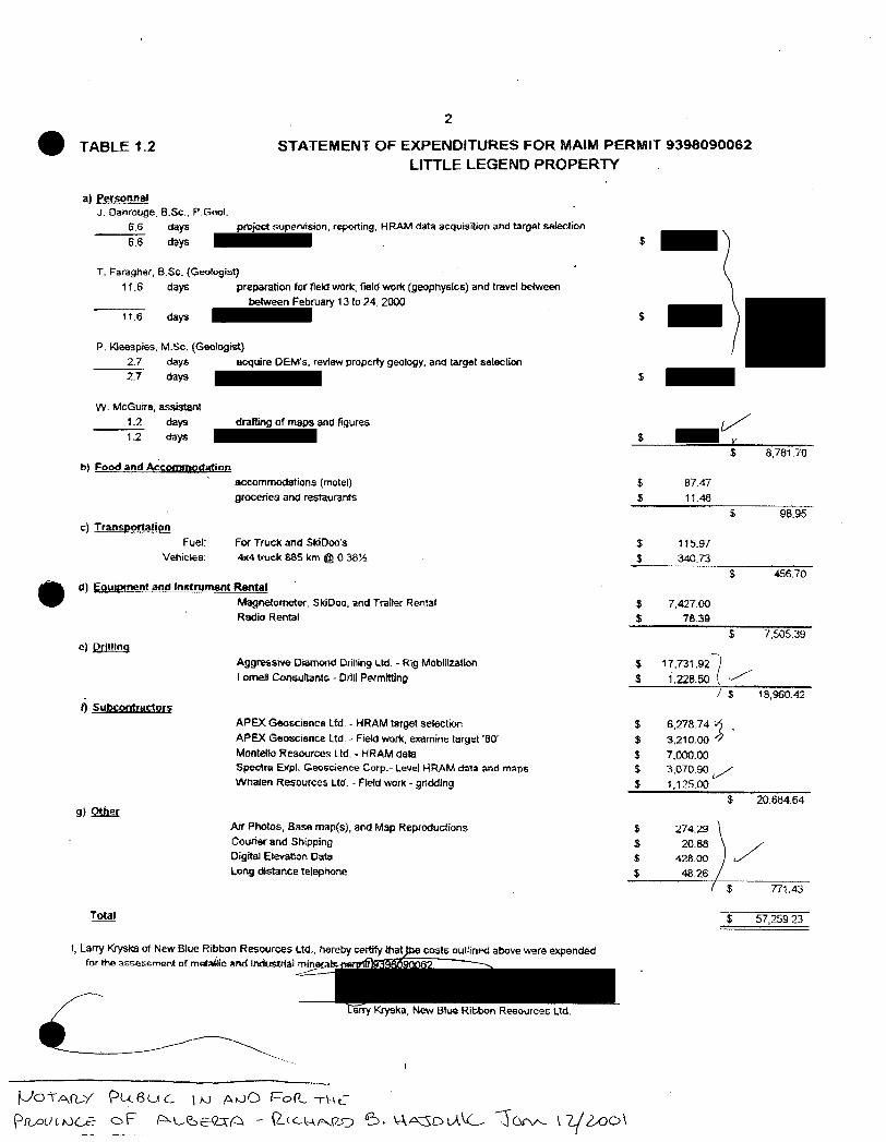
APEX Geoscience Ltd. - Field work, examine target '80'
Montello Resources Ltd. - HRAM data Spectra EXpl. Geoscience Corp.- I.eve! HRAM data and maps
Whalen Resources Ud. - Flefd work - gr1ddlng
$-$ -$ -$ -~ $
$ 87.47
$ 11.48 $
$ 115.97
$ 340.73
$
$ 7,427.00 $ 78.39
$
~.
$ 17,731.92 I
$ 1.228.50 ( ./ \
I $
$ 6,278.74 ~ . $ 3,210.00
$ 7,000.00 $ 3,070.90 ,/ $ 1,125.00
$
$ 274.;29
8,781.70
98.95
456.70
7,505.39
19,960.42
20.684.64
Afr Photos, Base map(s), and Map Reproductions Courier and Shipping
Digital Elevation Data $
$
20.88 / 428.00 Long distance telephone $ 48.26
$ 771.43
$ 57,259.23
I, Larry Kryska of New Blue Ribbon "Resour~s Ltd .. hereby certify that for tti .. ""'"'""men! o( mstalilc 11nd lndusrrfal mlnaral!:- m:liiii1!Cii'itiR?---
-----
/JO-t"Afl...-Y PL.zBU C \ >-J p..,vO F=°o(I~ Tl-\~
pn_,ouLtJ(..£- oF P>-L.-<::,E-<2:\A -· \2..tc..\,..\.,.,..,_(Z.O 6-:i. \..\A;3DLA\(_, J<1rv-..- l 2( 2-0o\
T.95 R.21W4 ···
T.96 R.20W4
Scale 0 1 -~---~
F2
2 Kilometers
NEW BLUE RIBBON RESOURCES LTD.
DAHROUGE GEOLOGICAL CONSULTING LTD. Edmonton, Alberta
Little Legend Property, Northern Alberta
Fig. 1.2 Metallic and Industrial Minerals Permit Map
JD 2001 01
'----' --*' ,_/ I
/ R_EGidJAL
0
) '" " ' ' ' - ' '
)
365000 E 36b000 E 3b7CIOO E
' ' \
'' ' ' \
'I 'J
l.lf,I J'le-HHI~ .1-1-1 I
--------,,.-__ .£-
,' ' '
'
368000 E 369000 £
RANGE 20W4 37000Q E 37l0QO E
1~
------ ---------372000 £ 373000 E 37~000 E 375000 E
RANGE 19 W4
SY~S-
HRAM target (Tabl~fr. t) ............. . ............................. -$14 HRAM target (high, medium, low priority) ~ ___r:bz rh