31
Discovery Report Chemung Watershed, HUC02050105 Chemung, Schuyler, and Steuben Counties, New York July 2, 2012

Discovery Report Chemung Watershed, HUC02050105 Chemung, Schuyler, and Steuben Counties, New York
July 2, 2012
i Discovery Report
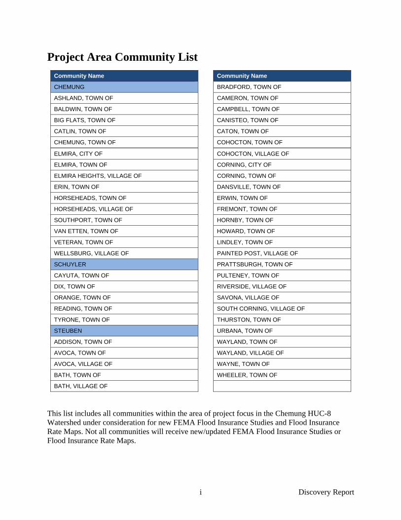
Project Area Community List
Community Name Community Name
CHEMUNG BRADFORD, TOWN OF
ASHLAND, TOWN OF CAMERON, TOWN OF
BALDWIN, TOWN OF CAMPBELL, TOWN OF
BIG FLATS, TOWN OF CANISTEO, TOWN OF
CATLIN, TOWN OF CATON, TOWN OF
CHEMUNG, TOWN OF COHOCTON, TOWN OF
ELMIRA, CITY OF COHOCTON, VILLAGE OF
ELMIRA, TOWN OF CORNING, CITY OF
ELMIRA HEIGHTS, VILLAGE OF CORNING, TOWN OF
ERIN, TOWN OF DANSVILLE, TOWN OF
HORSEHEADS, TOWN OF ERWIN, TOWN OF
HORSEHEADS, VILLAGE OF FREMONT, TOWN OF
SOUTHPORT, TOWN OF HORNBY, TOWN OF
VAN ETTEN, TOWN OF HOWARD, TOWN OF
VETERAN, TOWN OF LINDLEY, TOWN OF
WELLSBURG, VILLAGE OF PAINTED POST, VILLAGE OF
SCHUYLER PRATTSBURGH, TOWN OF
CAYUTA, TOWN OF PULTENEY, TOWN OF
DIX, TOWN OF RIVERSIDE, VILLAGE OF
ORANGE, TOWN OF SAVONA, VILLAGE OF
READING, TOWN OF SOUTH CORNING, VILLAGE OF
TYRONE, TOWN OF THURSTON, TOWN OF
STEUBEN URBANA, TOWN OF
ADDISON, TOWN OF WAYLAND, TOWN OF
AVOCA, TOWN OF WAYLAND, VILLAGE OF
AVOCA, VILLAGE OF WAYNE, TOWN OF
BATH, TOWN OF WHEELER, TOWN OF
BATH, VILLAGE OF
This list includes all communities within the area of project focus in the Chemung HUC-8 Watershed under consideration for new FEMA Flood Insurance Studies and Flood Insurance Rate Maps. Not all communities will receive new/updated FEMA Flood Insurance Studies or Flood Insurance Rate Maps.

ii Discovery Report
Table of Contents
1 Contents Table of Contents .......................................................................................................................... ii
List of Abbreviations ................................................................................................................... iv
1 General Information ................................................................................................................1
2 Watershed Stakeholder Coordination ...................................................................................5
3 Data Analysis ............................................................................................................................7 3.1 Topographic Data that Can Be Used for Flood Risk Products .........................................8 3.2 Community Information ...................................................................................................9
3.2.1 Socioeconomic Profile ..........................................................................................9 3.2.2 Mitigation Plans and Status ..................................................................................9 3.2.3 Hazus/Average Annualized Loss (AAL) ............................................................10 3.2.4 Flood Insurance and Repetitive Loss ..................................................................11 3.2.5 Coordinated Needs Management Strategy (CNMS) ...........................................12 3.2.6 Letters of Map Change (LOMCs) .......................................................................14 3.2.7 Floodplain Management/Community Assistance Visits .....................................15 3.2.8 Community Rating System (CRS) ......................................................................16 3.2.9 Regulatory Mapping ...........................................................................................17 3.2.10 Levees .................................................................................................................18 3.2.11 Dams ...................................................................................................................19 3.2.12 Disaster Declarations ..........................................................................................20 3.2.13 Stream Gages ......................................................................................................21 3.2.14 Additional Data Requested .................................................................................22
4 Discovery Meeting ..................................................................................................................24
5 References ...............................................................................................................................26 Appendices

iii Discovery Report
Tables Table 1: Proposed Scope of Study as of July 2012 ......................................................................... 2 Table 2: Chemung County Communities Invited to Participate ..................................................... 5 Table 3: Schuyler County Communities Invited to Participate ...................................................... 6 Table 4: Steuben County Communities Invited to Participate ........................................................ 6 Table 5: Data Collection for the Chemung Watershed ................................................................... 7 Table 6: Existing Multi-Jurisdictional Mitigation Plans within the Chemung Watershed ............. 9 Table 7: Communities with Individual Flood or Hazard Mitigation Plans .................................... 9 Table 8: CNMS Mileage for the Chemung Watershed ................................................................. 13 Table 9: Number of LOMCs per Community within the Chemung Watershed ........................... 15 Table 10: Community Assistance Visits in the Chemung Watershed since January 1, 2000 ...... 16 Table 11: Communities that Participate in CRS within the Chemung Watershed ....................... 17 Table 12: County Regulatory Mapping Status .............................................................................. 18 Table 13: Hazard Codes of Dams in the Chemung Watershed .................................................... 20 Table 14: Disaster Declarations in the Chemung Watershed ....................................................... 21 Table 15: USGS Stream Gage Information .................................................................................. 21 Figures Figure 1: Chemung Watershed Area Map ...................................................................................... 2 Figure 2: LiDAR Availability in Steuben and Schuyler Counties .................................................. 8 Figure 3: Average Annualized Flood Loss Data for the Chemung Watershed ............................ 11 Figure 4: CNMS Mileage, LOMCs, and Repetitive Loss Claims for the Chemung Watershed .. 14 Figure 5: Locations of USGS Stream Gages within the Watershed ............................................. 22
Appendices
Appendix A Discovery Meeting Sign-In Sheets
Appendix B Discovery Meeting Invitation
Appendix C Risk Map Data Request Form
Appendix D Discovery Meeting Interview Questions and Notes
Appendix D.1 – Summary
Appendix D.2 – Full Spreadsheet
Appendix E Levee Handouts
Appendix F Evaluation Form
Appendix G Discovery Meeting Agenda
Appendix H Chemung Watershed Stakeholder Contact List
Appendix I: Response to Southern Tier Central Regional Planning & Development Board questions on the November, 2010 Chemung County Draft Flood Insurance Study
Appendix J: Southern Tier Regional Planning and Development Board Floodplain Mapping Restudy Request, October 31, 2008

iv Discovery Report
List of Abbreviations CAV Community Assistance Visit
CLOMR Conditional Letter of Map Revision
CNMS Coordinated Needs Management Strategy
CRS Community Rating System
FEMA Federal Emergency Management Agency
FIS Flood Insurance Study
GIS Geographic Information System
HAZUS-MH Multi-Hazard Risk Assessment and Loss Estimation Software Program
LiDAR Light Detection and Ranging
LOMA Letter of Map Amendment
LOMC Letter of Map Change
LOMR Letter of Map Revision
LOMR-F Letter of Map Revision based on fill
MIP Mapping Information Platform
MLI Mid-term Levee Inventory
MSC Map Service Center
NFIP National Flood Insurance Program
NHD National Hydrography Dataset
NYSDEC New York State Department of Environmental Conservation
NYSDOT New York State Department of Transportation
NYS GIS New York State Geographic Information System (Clearinghouse)
RAMPP Risk Assessment, Mapping, and Planning Partners
Risk MAP Risk Mapping, Assessment, and Planning
SFHA Special Flood Hazard Area
STRPDB Southern Tier Regional Planning and Development Board
SWCD Soil and Water Conservation District
USACE U.S. Army Corps of Engineers
USGS U.S. Geological Survey

1 Discovery Report
1 General Information The Federal Emergency Management Agency’s (FEMA’s) Risk Mapping, Assessment, and Planning (Risk MAP) program provides communities with flood risk information based on a watershed model and tools that can be used to enhance mitigation plans and better protect citizens. Risk MAP promotes early and frequent communication with project partners (including all affected communities) to approach risk assessment and mitigation planning on a watershed basis. Discovery is a new FEMA initiative that involves data mining, collection, and analysis. The new initiative will support efforts to lay a foundation for the critical messages of Risk MAP: resiliency, risk assessments, and mitigation planning. Region II initiated its first Discovery project in the Chemung Watershed (Hydrologic Unit Code 02050105), a project area involving over 50 separate communities. This report summarizes the Discovery tasks that were conducted for the watershed in FEMA Region II by FEMA’s Regional Support Center.
The FEMA Region II Discovery data task entailed collecting extensive tabular and spatial data for all communities from federal and state sources, as well as collecting information through community meetings, phone interviews, and Discovery data questionnaires sent to each community. (Section 3 of this report lists the types of data that the project team collected for the watershed.) Discovery tasks culminated with a community meeting with stakeholders in the watershed and the development of study recommendations based on an analysis of data and information gathered throughout the process. As a final project scope is determined, FEMA will work with Chemung Watershed stakeholders to develop a Memorandum of Partnership (Project Charter) that documents the final scope of work for the Risk MAP project.
The Chemung Watershed is in the southern tier of New York State, dipping slightly into Pennsylvania. The drainage area is approximately 1,700 square miles and comprises approximately one-eighth of the larger Susquehanna River Basin. According to the National Hydrography Dataset (NHD), there are approximately 1,270 stream miles within the watershed. The primary tributary is the Chemung River, which flows across the western portion of the southern tier of New York State before joining the Susquehanna River and eventually emptying into the Chesapeake Bay.
The Discovery process focused on the three primary counties within the Chemung Watershed in New York State: Chemung, Steuben, and a small portion of Schuyler. The watershed also touches Bradford and Tioga Counties in Pennsylvania. New county-wide Flood Insurance Studies (FIS) and Flood Insurance Rate Map (FIRM) projects are currently underway for these counties through FEMA Region III and were not included as part of the Chemung Watershed Discovery project. Similarly, very small portions of Livingston, Ontario, Yates, and Tioga Counties in New York State are within the watershed. Those communities were invited to the Chemung Watershed Kickoff meeting in February 2011; however, they were invited for informational purposes only. These communities were not interviewed during the Discovery process and their community-specific issues were not considered for new stream studies. However, all communities within the New York State portion of the watershed will receive a Flood Risk Report, a Flood Risk Map, and a Flood Risk Database that includes Average Annualized Loss for flooding at the Census Block level. Figure 1 (Page 2) shows the location of the watershed in relation to the surrounding New York State and Pennsylvania counties.
2 Discovery Report
The final phase of the Discovery effort involved an analysis of the data and information collected and discussed at the meetings as well as subsequent communications through telephone calls, email, and additional meetings. The Discovery Maps are an integral part of the Discovery Report. The Discovery Report itself documents the results of data collection and map content.
Figure 1: Chemung Watershed Area Map
Table 1 below lists the proposed scope of study for the three counties in the watershed by stream name and study type.
Table 1: Proposed Scope of Study as of July 2012
County Stream Name Study Type Miles
Chemung Bentley Creek* Detailed 1.53
Chemung Chemung River Detailed 26.15
Chemung Chemung River Incorporate detailed Pennsylvania data 5.06
Chemung Cuthrie Run Detailed 3.47
Chemung Diven Creek Detailed 0.99
Chemung Hoffman Brook Detailed 5.32
Chemung Newtown Creek Detailed 13.37
Chemung North Branch Newtown Creek Detailed 1.72
Chemung Prospect Creek (Horseheads Creek) Detailed 3.34
Chemung Seeley Creek Detailed 10.74
Chemung Sing Sing Creek Detailed 10.36
Chemung South Creek Detailed 1.79

3 Discovery Report
County Stream Name Study Type Miles
Chemung Unnamed Tributary to Seeley Creek Detailed 0.52
Schuyler Coon Hollow Creek Approximate 0.99
Schuyler Lakoma Lake Zone A Approximate 0.79
Schuyler Meads Creek Detailed 5.0
Schuyler Meads Creek Approximate 0.92
Schuyler Mill Pond Zone A Approximate 0.74
Schuyler Mud Creek Approximate 0.83
Schuyler Sexton Hollow Creek Approximate 0.84
Schuyler Unnamed Approximate 4.64
Steuben Borden Creek Approximate 4.11
Steuben Canisteo River Digital Lift Up 3.86
Steuben Caton Creek Approximate 0.13
Steuben Chemung Feeder Canal Approximate 1.80
Steuben Chemung River Detailed 8.08
Steuben Cohocton River Validate Effective Study 16.42
Steuben Cohocton River Validate Effective Study/Redelineation 12.53
Steuben Curtis Creek Approximate 0.35
Steuben Cutler Creek Approximate 5.58
Steuben Cutler Creek Detailed 1.02
Steuben Dry Run Approximate 10.33
Steuben Erwin Creek Approximate 3.08
Steuben Frog Hollow Approximate 1.80
Steuben Hodgmans Creek Validate Effective Study 0.43
Steuben McNutt Run Validate Effective Study/Redelineation 0.46
Steuben McNutt Run Approximate 0.78
Steuben Meads Creek Detailed 9.89
Steuben Michigan Creek Validate Effective Study/Redelineation 1.75
Steuben Post Creek Approximate 7.23
Steuben Post Creek Detailed 0.82
Steuben Salmon Creek Validate Effective Study 1.64
Steuben Stanton Creek Approximate 1.04
Steuben Tioga River Digital Lift Up 6.02
Steuben Tributary To Meads Creek Detailed 0.99
Steuben Unnamed Tributary to Michigan Creek Validate Effective Study/Redelineation 0.25
Steuben Unnamed Approximate 40.64
Steuben Whisky Creek Approximate 0.30
Steuben Wilson Hollow Approximate 2.79
Steuben Wolf Run Validate Effective Study/Redelineation 2.61
Steuben Wolf Run Approximate 1.54
* RAMPP team is expected to validate the usability of the NRCS models and elements, for inclusion into the 1.53 scoped stream mileage for Bentley creek. It is important to note that the NRCS models and engineering notes refer to a scope of 7.65 miles upstream into PA (Bradford County) but no new hazard updates are expected to be incorporated in the county at the moment.

4 Discovery Report
Explanation of Study Types: Approximate: Perform Hydrology using NED dataset and 2006 USGS regression equations. Perform Hydraulics analysis and mapping using updated topographic data (LiDAR) and HECRAS Models. Re-delineation: Update effective floodplains and associated detailed flood elevations using LiDAR data. Effective engineering analysis is preserved. Re-study: Conduct new Hydrologic and Hydraulic analyses using LiDAR data to revise the 1%- and 0.2%- annual-chance flood hazard areas. Digital Lift Up: Effective flood hazard data is converted into a digital format with only an updated vertical datum (from NGVD29 to NAVD88). Effective engineering analysis and flood hazard areas are preserved. Validate Effective Study: Effective flood hazard engineering and mapping information of a stream study is captured and taken through a 17 element validation process. Validate Effective Study/Redelineation: Effective flood hazard engineering and mapping information of a stream study is captured and taken through a 17 element validation process. If the stream study is found to be “valid”, then it is selected for redelineation.
5 Discovery Report
2 Watershed Stakeholder Coordination Because of the extent of the Chemung Watershed, the distribution of its population in approximately 52 separate, autonomous jurisdictions, and the presence of interested groups and government agencies, communication to all potential stakeholders will be time-consuming and, at the same time, critical. To communicate effectively throughout the life of a Risk MAP project in this watershed, the use of e-mail, telephone, and letters will be essential. Several hundred people were contacted in the various communities throughout the watershed to determine who the best point of contact for each community or entity should be. Once these contacts were determined, a master list of 95 key stakeholders was established and will be maintained by FEMA Region II. Invitations to the Discovery meeting were sent to everyone on this list. The names and contact information for those that attended the meeting are included as Appendix A, a sample invitation is included as Appendix B, and a list of Chemung Watershed stakeholder contacts is included as Appendix H.
Representatives from the local governments, including 52 cities, towns, and villages, are considered fundamental stakeholders in this process because they have been elected or appointed to represent the interests of the residents in the watershed. In addition to local governments, the county officials of Chemung, Steuben, and Schuyler Counties were invited to participate in the Discovery meetings. In New York State, the county officials often have a breadth of knowledge on local issues, Geographic Information Systems (GIS), and other technical capabilities, as well as the planning authority to assist FEMA with Flood Insurance Rate Map revisions and other information, such as mitigation plan status.
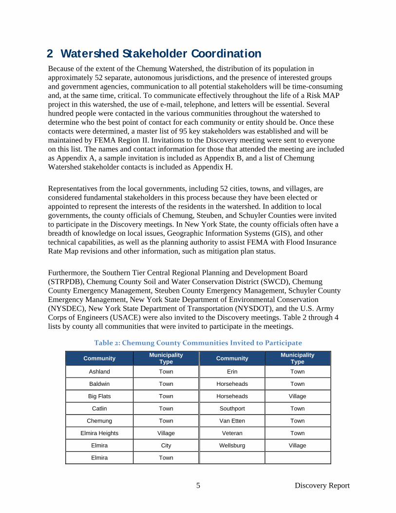
Furthermore, the Southern Tier Central Regional Planning and Development Board (STRPDB), Chemung County Soil and Water Conservation District (SWCD), Chemung County Emergency Management, Steuben County Emergency Management, Schuyler County Emergency Management, New York State Department of Environmental Conservation (NYSDEC), New York State Department of Transportation (NYSDOT), and the U.S. Army Corps of Engineers (USACE) were also invited to the Discovery meetings. Table 2 through 4 lists by county all communities that were invited to participate in the meetings.
Table 2: Chemung County Communities Invited to Participate
Community Municipality
Type Community
Municipality Type
Ashland Town Erin Town
Baldwin Town Horseheads Town
Big Flats Town Horseheads Village
Catlin Town Southport Town
Chemung Town Van Etten Town
Elmira Heights Village Veteran Town
Elmira City Wellsburg Village
Elmira Town
6 Discovery Report
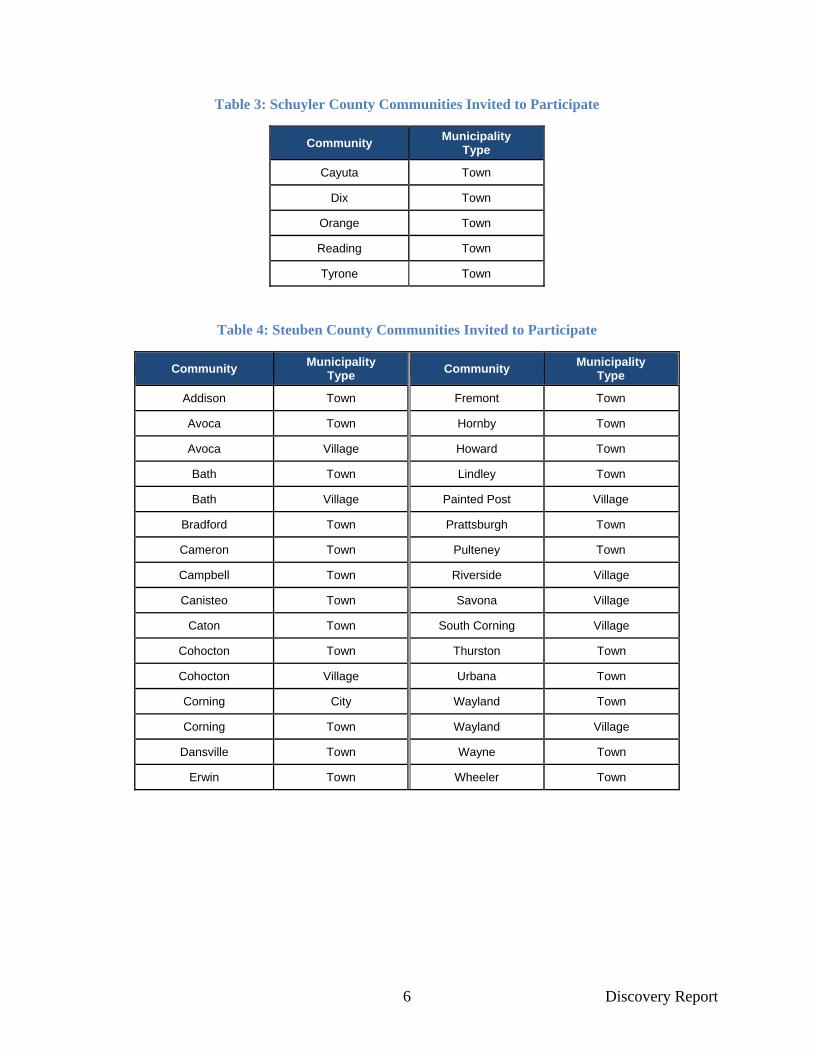
Table 3: Schuyler County Communities Invited to Participate
Community Municipality
Type
Cayuta Town
Dix Town
Orange Town
Reading Town
Tyrone Town
Table 4: Steuben County Communities Invited to Participate
Community Municipality
Type Community
Municipality Type
Addison Town Fremont Town
Avoca Town Hornby Town
Avoca Village Howard Town
Bath Town Lindley Town
Bath Village Painted Post Village
Bradford Town Prattsburgh Town
Cameron Town Pulteney Town
Campbell Town Riverside Village
Canisteo Town Savona Village
Caton Town South Corning Village
Cohocton Town Thurston Town
Cohocton Village Urbana Town
Corning City Wayland Town
Corning Town Wayland Village
Dansville Town Wayne Town
Erwin Town Wheeler Town

7 Discovery Report
3 Data Analysis Table 5 below lists the data types collected during the Discovery process, the deliverable or product in which the data are included, and the source of the data. In addition, the discussion of Data Analysis is divided into two sections: one section for the data that can be used for Risk MAP products (regulatory and non-regulatory) and one section for the other data and information that assisted the project team to form a more holistic understanding of this watershed.
In February 2011, the communities within the watershed were invited to a Project Kickoff Meeting. During that meeting, community officials were presented with the Risk MAP Discovery concept and asked to participate in the months to come. Every community present was also given a packet of information, including a data request form (see Appendix C). The communities present were asked to review the form and to provide any relevant information to the FEMA project team. This data request form, included as Appendix C, was also sent to communities that did not attend the Kickoff meeting with the same request.
Table 5: Data Collection for the Chemung Watershed
Data Types Deliverable/Product Source
Average Annualized Loss Data Discovery Map Geodatabase Brian Shumon, FEMA Region II
Boundaries: Community Discovery Map Geodatabase New York State GIS (NYS GIS) Clearinghouse/Pennsylvania Spatial Data
Access Boundaries: County and State Discovery Map Geodatabase National Atlas of the United States
Boundaries: Watersheds Discovery Map Geodatabase U.S. Geological Survey (USGS) NHD
Census Blocks Discovery Map Geodatabase U.S. Census Bureau
Contacts Table Local Web Sites, State/FEMA Updates
Community Assistance Visits Discovery Report Community Information System (CIS)
Community Rating System (CRS) Discovery Report FEMA’s “Community Rating System Communities and Their Classes”
Dams and Levees Discovery Map Geodatabase FEMA Mid-term Levee Inventory (MLI)/USACE/New York State Department of Environmental Conservation/NYS GIS
Clearinghouse Declared Disasters Discovery Report FEMA’s “Disaster Declarations Summary”
Demographics Discovery Report U.S. Census Bureau
Effective Floodplains (Steuben/Schuyler), Draft Prelim
Floodplains (Chemung): Special Flood Hazard Areas
(SFHAs)
Discovery Map Geodatabase FEMA’s Map Service Center (MSC) and Mapping Information Platform (MIP)
Stream Gages Discovery Map Geodatabase USGS
Hazards Mitigation Plans and Status
Discovery Report Community Web Sites, FEMA Regional Office

8 Discovery Report
Data Types Deliverable/Product Source
High Water Marks Discovery Map and Geodatabase Irwan Ab Razak, URS Group
Flood Insurance Claims Discovery Map and Report Community Information System (CIS)
Letters of Map Change (LOMCs) Discovery Report and Map
FEMA’s Mapping Information Platform
Mitigation Projects: Past, Ongoing, Planned, Desired FEMA/Other Federal Agency/Local Projects
Discovery Report Appendix D Compiled through Community Interviews
Repetitive Loss Discovery Report and Map CIS
Stream Centerlines Discovery Map and Geodatabase National Hydrography Dataset
Study Needs: FEMA Discovery Map and Geodatabase Coordinated Needs Management Strategy (CNMS)
StudyRequests: Discovery Report Compiled through Community Interviews
Transportation: Major Roads Discovery Map and Geodatabase NYS GIS Clearinghouse
3.1 Topographic Data that Can Be Used for Flood Risk Products Elevation data is available for all areas within the Chemung Watershed. Light Detection and Ranging (LiDAR) for the entirety of Chemung County was collected and processed in 2005. The areas of Schuyler and Steuben Counties within the Chemung Watershed were collected in 2011. Processed LiDAR data is available for portions of Steuben and Schuyler, while raw, unprocessed LiDAR data is available for all areas of Steuben and Schuyler Counties within the watershed, see Figure 2 below. LiDAR data collection was performed by Risk Assessment, Mapping, and Planning Partners (RAMPP), a joint venture company composed of Dewberry, URS Corporation, and ESP Associates. This elevation data is available for any public or non-government organization upon request to FEMA.
Figure 2: LiDAR Availability in Steuben and Schuyler Counties
Cyan tiles indicate areas of fully processed LiDAR
Magenta and grey tiles are available in LAS format only

9 Discovery Report
3.2 Community Information
3.2.1 Socioeconomic Profile
The Chemung Watershed contains approximately 150,000 residents throughout its 52 communities. The largest community is the City of Elmira, the county seat of Chemung County, with approximately 30,000 residents. Chemung County has a homeownership rate of 69 percent. Approximately 19 percent of Chemung County residents hold a bachelor’s degree or higher. The median household income is $41,900. Schuyler County has a slightly higher homeownership rate, at 77 percent, with 16 percent of its residents holding a bachelor’s degree or higher. The median household income in Schuyler is $45,200. In Steuben County, the homeownership rate is 78 percent, with a median household income of $48,400 and 16 percent of residents holding a bachelor’s degree or higher. The primary industries in this area include manufacturing, wholesale/retail trade, construction, and transportation/utilities.
3.2.2 Mitigation Plans and Status
The statuses of the current hazard mitigation plans for Chemung, Schuyler, and Steuben Counties are shown in Table 6 below. Several communities in the watershed also have individual mitigation plans. They are listed in Table 7 below. Additional information from the communities regarding hazard mitigation plans was collected and recorded at the Discovery meetings in May 2011. This information is included in Appendix D.
Table 6: Existing Multi-Jurisdictional Mitigation Plans within the Chemung Watershed
County Mitigation Plan Approval Date
Web site
Chemung Pending Adoption
N/A
Steuben 3/23/2010 http://www.steubencony.org/pages.asp?PID=286
Schuyler 8/26/2008 http://www.stcplanning.org/usr/Program_Areas/Hazard_Mitigation/SchuylerHazP
lan2008WithMaps.pdf
Table 7: Communities with Individual Flood or Hazard Mitigation Plans
County Community Mitigation Plan Date
Web site
Chemung Ashland, Town of 8/31/99 http://www.stcplanning.org/usr/Program_Areas/Hazard_
Mitigation/Flood_Mit_Plan_Ashland_1999.pdf
Steuben Avoca, Town of; Bath, Village and Town of
4/30/2001 http://www.stcplanning.org/usr/Program_Areas/Hazard_
Mitigation/Flood_Mit_Plan_Avoca_Bath_2001.pdf
Chemung Big Flats, Town of 10/29/2004 http://www.stcplanning.org/usr/Program_Areas/Hazard_
Mitigation/BigFlatsHazardPlan.pdf
Chemung Elmira, Town of 10/29/2004 http://www.stcplanning.org/usr/Program_Areas/Hazard_
Mitigation/TElmiraHazardPlan.pdf
Chemung Erin, Town of; Van Etten, Town and
Village of 8/26/2008
http://www.stcplanning.org/usr/Program_Areas/Hazard_Mitigation/Flood_Mit_Plan_Erin_VanEtten_2001.pdf
Steuben Erwin, Town of;
Campbell, Town of 8/31/1999
http://www.stcplanning.org/usr/Program_Areas/Hazard_Mitigation/Flood_Mit_Plan_Erwin_Campbell_1999.pdf
Steuben Hornell, City of; North
Hornell, Village of; Hornellsville, Town of
9/30/2002 http://www.stcplanning.org/usr/Program_Areas/Hazard_
Mitigation/Flood_Mit_Plan_Hornell_2002.pdf
10 Discovery Report
County Community Mitigation Plan Date
Web site
Chemung Veteran, Town of; Millport, Village of
9/30/1999 http://www.stcplanning.org/usr/Program_Areas/Hazard_Mitigation/Flood_Mit_Plan_Veteran_Millport_1999.pdf
Chemung Wellsburg, Village of 7/30/1999 http://www.stcplanning.org/usr/Program_Areas/Hazard_
Mitigation/Flood_Mit_Plan_Wellsburg_1999.pdf
Steuben Erwin, Town of 11/30/2004 http://www.stcplanning.org/usr/Program_Areas/Hazard_
Mitigation/ErwinHazardPlan.pdf
Chemung Horseheads, Town
and Village of 10/29/2004
http://www.stcplanning.org/usr/Program_Areas/Hazard_Mitigation/HorseheadsHazardPlan.pdf
Chemung Southport, Town of 10/29/2004 http://www.stcplanning.org/usr/Program_Areas/Hazard_
Mitigation/SouthportHazardPlan.pdf
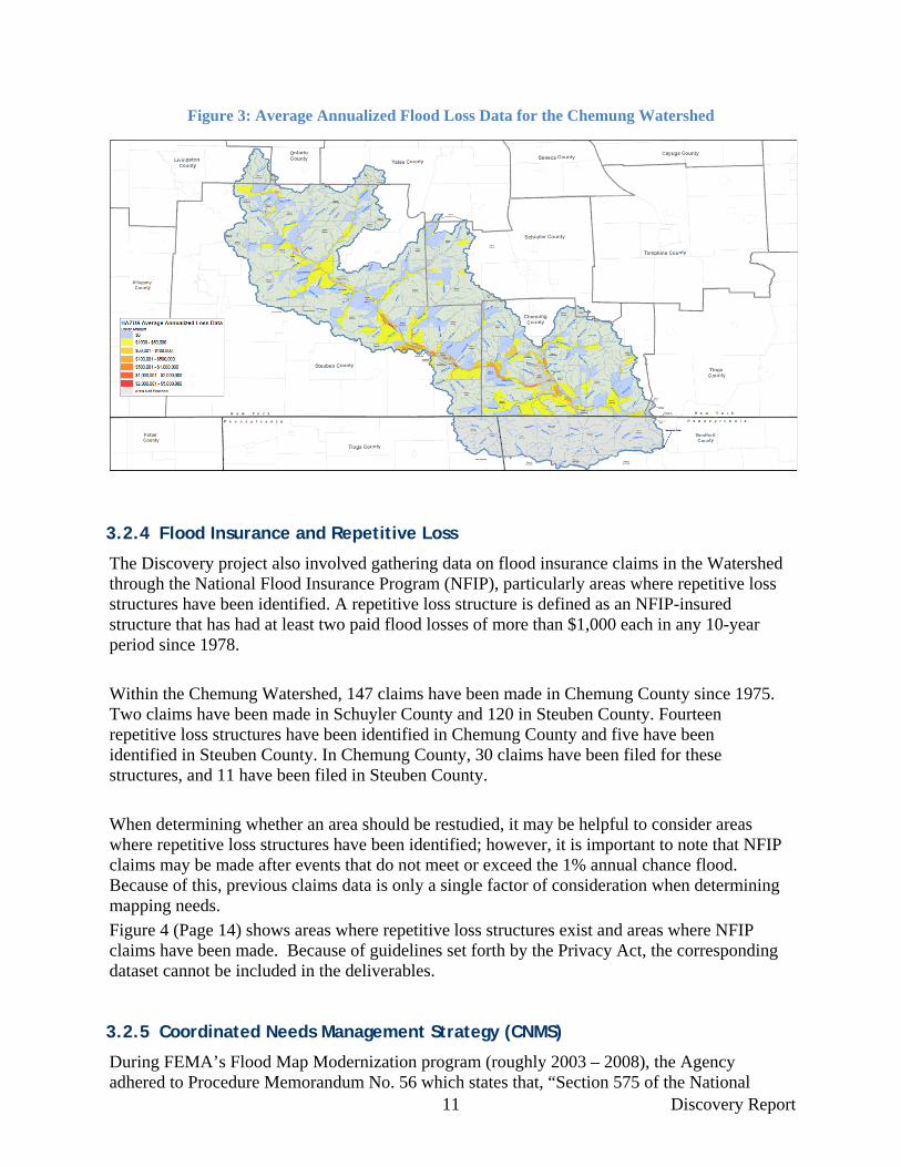
3.2.3 Hazus/Average Annualized Loss (AAL)
In reference to flooding, Average Annualized Loss (AAL) is defined as the average dollar loss that an individual, or individuals, will experience over a given year from exposure to flooding. This AAL dollar value is calculated by using flood hazard data in combination with US Census data. Flood hazard areas are determined for storm events of a given probability of occurrence and are then overlaid with US Census block data. The losses for a given census block are then calculated for the structures and structures’ contents based on the area that is considered inundated by flooding. Total losses for both the structures and the structures’ contents are added together yielding the AAL for a given census block. The AAL for a community can then be determined by adding the AAL together for all its census blocks. However, AAL data is usually mapped by census block and displayed with color intervals based on severity of losses. The AAL dataset provided with this Discovery Report and shown on the Discovery Map (also displayed in Figure 3, Page 11) was created using FEMA's Hazards U.S. Multi-Hazard Risk Assessment and Loss Estimation software (Hazus-MH). The Hazus-MH analysis was based upon data sources with limited detail for computation of flood hazard areas such as the 30-meter USGS digital elevation model (DEM) and hydrology determined with statewide regression equations. Hazus-MH analyses performed with this degree of detail are known as Level 1 analyses and the primary purpose of the datasets is to correlate the location of residents and infrastructure to the floodplain within a given community rather than to provide a thorough and accurate estimation of yearly losses from flooding (AAL). A complete, watershed-wide AAL dataset will be created during the Chemung Watershed FIS and delivered through the Risk MAP database product. The AAL dataset will be produced using high resolution elevation and hydrological datasets and will provide a much more accurate estimate of AAL for each community.
11 Discovery Report
Figure 3: Average Annualized Flood Loss Data for the Chemung Watershed
3.2.4 Flood Insurance and Repetitive Loss
The Discovery project also involved gathering data on flood insurance claims in the Watershed through the National Flood Insurance Program (NFIP), particularly areas where repetitive loss structures have been identified. A repetitive loss structure is defined as an NFIP-insured structure that has had at least two paid flood losses of more than $1,000 each in any 10-year period since 1978.
Within the Chemung Watershed, 147 claims have been made in Chemung County since 1975. Two claims have been made in Schuyler County and 120 in Steuben County. Fourteen repetitive loss structures have been identified in Chemung County and five have been identified in Steuben County. In Chemung County, 30 claims have been filed for these structures, and 11 have been filed in Steuben County.
When determining whether an area should be restudied, it may be helpful to consider areas where repetitive loss structures have been identified; however, it is important to note that NFIP claims may be made after events that do not meet or exceed the 1% annual chance flood. Because of this, previous claims data is only a single factor of consideration when determining mapping needs.
Figure 4 (Page 14) shows areas where repetitive loss structures exist and areas where NFIP claims have been made. Because of guidelines set forth by the Privacy Act, the corresponding dataset cannot be included in the deliverables.
3.2.5 Coordinated Needs Management Strategy (CNMS)
During FEMA’s Flood Map Modernization program (roughly 2003 – 2008), the Agency adhered to Procedure Memorandum No. 56 which states that, “Section 575 of the National
12 Discovery Report
Flood Insurance Program Reform Act of 1994 mandates that at least once every five years FEMA assess the need to review and update all floodplain areas and flood risk zones identified, delineated, or established under Section 1360 of the National Flood Insurance Act, as amended.” This requirement was fulfilled through the Mapping Needs Assessment process. Other mechanisms such as the Mapping Needs Update Support System (MNUSS) and scoping reports were used to capture information describing conditions on the FIRMs and the potential for a map update.
FEMA’s Coordinated Needs Management Strategy (CNMS) was initiated through FEMA’s Risk MAP program in 2009. Prior to the 2011 Discovery meetings in the Chemung Watershed, the CNMS database was updated with the November 2010 Chemung County draft preliminary Flood Insurance Study (FIS) and Flood Insurance Rate Map (FIRM), the 2005 Chemung County scoping reports and the Southern Tier Central Regional Planning & Development Board's floodplain mapping restudy request letter, dated October 31, 2008 (see Appendix J).
There are three classifications within the CNMS; “Valid,” “Unverified,” and “Unknown.” New and updated studies (new hydrologic and hydraulic models) performed during the Map Modernization program were automatically determined to be “Valid” and the remaining studies went through a 17 element validation process (7 critical and 10 secondary). Validation elements apply Physical, Climatological, and Environmental (PCE) factors to stream studies to determine validity. A stream study has to pass all the critical elements and at least 7 secondary elements in order to be classified as “Valid,” otherwise they are classified as “Unverified.”
To date, the CNMS has gone through three phases of assessment; the CNMS Phase 1 (early 2009) created a national map showing approximate new, valid, or updated Special Flood Hazard Area (SFHA) percentage at a county level. The CNMS Phase 2 (August – November 2009) created a CNMS database and performed bulk validation where new and updated studies performed during the Map Modernization program were automatically determined to be valid; digital conversion and pre-Map Modernization approximate studies were automatically invalid. The CNMS Phase 3 (October 2010 – June 2011) confirmed all bulk validation assignments and put all other stream reaches that were not bulk validated through the 17 element process. Currently, in the post Phase 3 stage, the CNMS database is maintained through regular updates and information is added as new studies are conducted.
The Chemung County CNMS database was not processed through the CNMS Phase 3 as the County-wide project was originally scheduled for draft/preliminary release during the Phase 3 work. Guidance from Phase 2 allowed for the utilization of scoping data to inform validation status for streams in the CNMS database.
When the draft preliminary FIS/FIRM was issued for Chemung County, all attributes for streams within the County were revised to reflect actual conditions in the CNMS database (“Valid”/”Unverified”).
The guidelines for CNMS Phase 3 dictates that non-digital studies should be placed into a holding category until such time that local knowledge can be applied to the validation process as the necessary data for the 17 validation element process would not be available. The
13 Discovery Report
attributes for current effective studies in Schuyler and Steuben Counties are in this category with the CNMS, labeled with an “Unknown” validation status as shown in Figure 4 (Page 14).
There are many elements that are taken into consideration when classifying a study as “Unverified”. The age of the study is considered, but it is not the determining factor. In fact, as many as 70% of the studies thought to be out-of-date, when put through the full 17 validation element process in CNMS Phase 3 process, were determined to be “Valid”. However, if a study request is submitted for one these areas and approved by the FEMA Region II, the possibility exists that the Validation Status will be set to “Unverified” for these studies as a result.
Although the Chemung County FIS and FIRMs that were published during the countywide Map Modernization project were draft studies, the detailed quality control process was completed. Those Chemung County streams that are classified as “Valid” in the CNMS database are all approximate study (Zone A) streams that were re-studied (with new hydrology and hydraulic models) through the draft Chemung County-wide FIS.
Additionally, while streams without identified flood risk can be featured in the CNMS database, most are not. In the case of Steuben/Schuyler, these streams were not in the CNMS database but stored in a separate dataset. Streams without flood hazard information cannot go through any sort of element evaluation as the elements which comprise the evaluation are based upon study or study date dependent characteristics. The forthcoming CNMS database (post Phase 3) will hold all unmapped streams. For this project, community-specific evaluation requests will be documented as mapping requests for FEMA Region II review and consideration.
The CNMS database information was utilized during the initial Chemung Watershed Discovery effort and served as an important discussion point. The Discovery process yielded new flood risk needs information from communities and was incorporated into the CNMS database as requests.
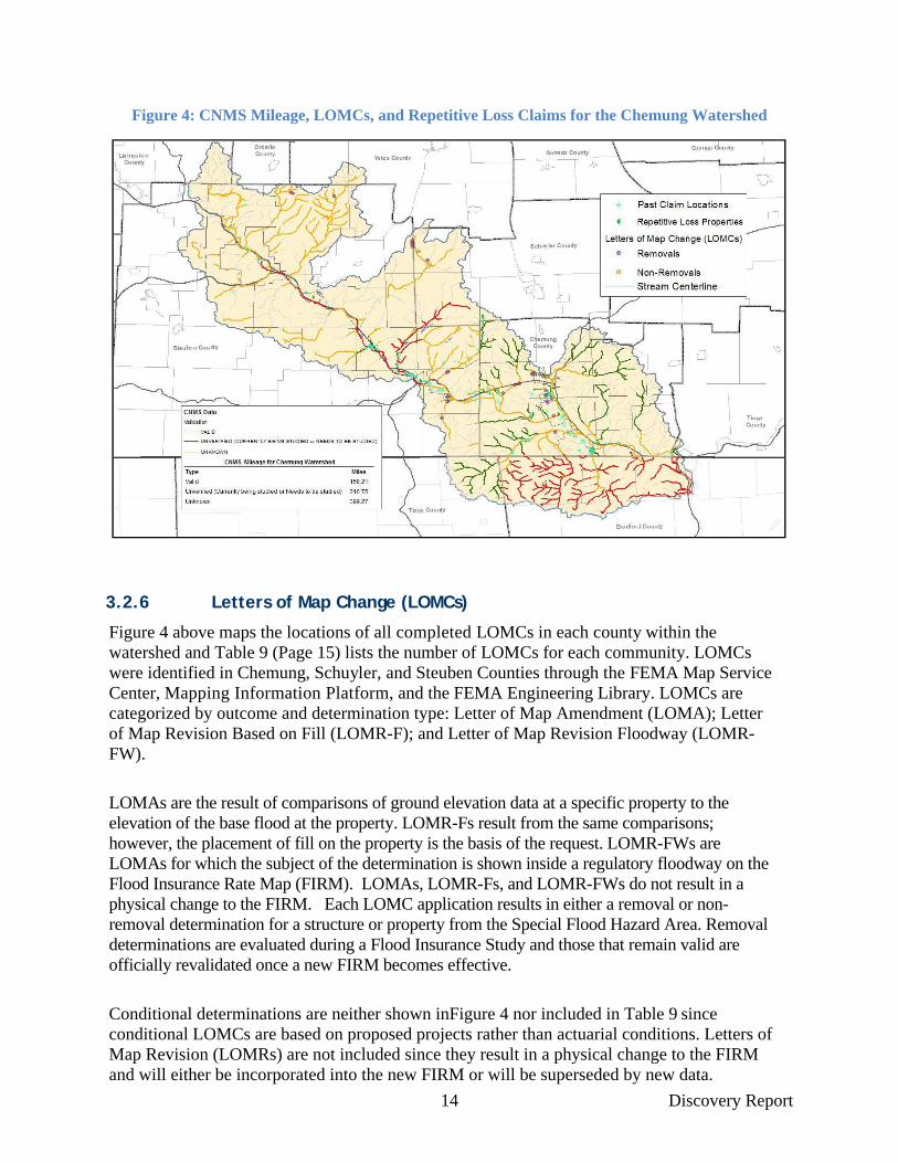
Table 8 below summarizes draft results of the validation analysis obtained from the CNMS. A significant stretch of stream mileage in the watershed still has an “Unknown” validation status. The breakdown of stream status is shown in Figure 4 (Page 14).
Table 8: CNMS Mileage for the Chemung Watershed
Type Miles
Valid 158.21
Currently being studied/Needs to be studied 210.75
Unknown 399.27
14 Discovery Report
Figure 4: CNMS Mileage, LOMCs, and Repetitive Loss Claims for the Chemung Watershed
3.2.6 Letters of Map Change (LOMCs)
Figure 4 above maps the locations of all completed LOMCs in each county within the watershed and Table 9 (Page 15) lists the number of LOMCs for each community. LOMCs were identified in Chemung, Schuyler, and Steuben Counties through the FEMA Map Service Center, Mapping Information Platform, and the FEMA Engineering Library. LOMCs are categorized by outcome and determination type: Letter of Map Amendment (LOMA); Letter of Map Revision Based on Fill (LOMR-F); and Letter of Map Revision Floodway (LOMR-FW).
LOMAs are the result of comparisons of ground elevation data at a specific property to the elevation of the base flood at the property. LOMR-Fs result from the same comparisons; however, the placement of fill on the property is the basis of the request. LOMR-FWs are LOMAs for which the subject of the determination is shown inside a regulatory floodway on the Flood Insurance Rate Map (FIRM). LOMAs, LOMR-Fs, and LOMR-FWs do not result in a physical change to the FIRM. Each LOMC application results in either a removal or non-removal determination for a structure or property from the Special Flood Hazard Area. Removal determinations are evaluated during a Flood Insurance Study and those that remain valid are officially revalidated once a new FIRM becomes effective.
Conditional determinations are neither shown inFigure 4 nor included in Table 9 since conditional LOMCs are based on proposed projects rather than actuarial conditions. Letters of Map Revision (LOMRs) are not included since they result in a physical change to the FIRM and will either be incorporated into the new FIRM or will be superseded by new data.

15 Discovery Report
The presence or absence of completed LOMCs within a specified location may contribute to the analysis of whether that area needs to be restudied. Knowing the type of LOMC and its respective outcome can provide an additional layer of detail. For example, a high number of LOMA removals indicate that an area may need to be restudied with updated topography, while a high number of LOMA non-removals may indicate that the flood hazard delineation within the area agrees with ground elevations. A high number of LOMR-Fs may not necessarily indicate that an area should be reexamined, but it indicates that property owners have cooperated with the local municipality to mitigate against flooding in accordance with local regulations.
Table 9: Number of LOMCs per Community within the Chemung Watershed
County Community Name Number of
LOMA Removals
Number of LOMA Non-Removals
Number of LOMR-F
Removals
Number of LOMR-FW Removals
Total
Chemung Big Flats, Town of 1 2 0 2 5
Chemung Elmira Heights, Village of 2 3 0 0 5
Chemung Elmira, City of 1 0 0 1 2
Chemung Elmira, Town of 1 0 0 0 1
Chemung Horseheads, Town of 2 2 4 3 11
Chemung Horseheads, Village of 4 3 0 0 7
Chemung Southport, Town of 0 0 1 0 1
Chemung Wellsburg, Village of 1 0 0 0 1
Schuyler Tyrone, Town of 1 2 0 0 3
Steuben Bath, Village of 0 0 2 0 2
Steuben Campbell, Town of 5 2 0 0 7
Steuben Caton, Town of 1 0 0 0 1
Steuben Corning, Town of 6 0 0 0 6
Steuben Erwin, Town of 0 0 1 0 1
Steuben Prattsburg, Town of 3 0 0 0 3
Steuben South Corning, Village of 1 1 1 0 3
Steuben Wayne, Town of 11
3 0 0 14
3.2.7 Floodplain Management/Community Assistance Visits
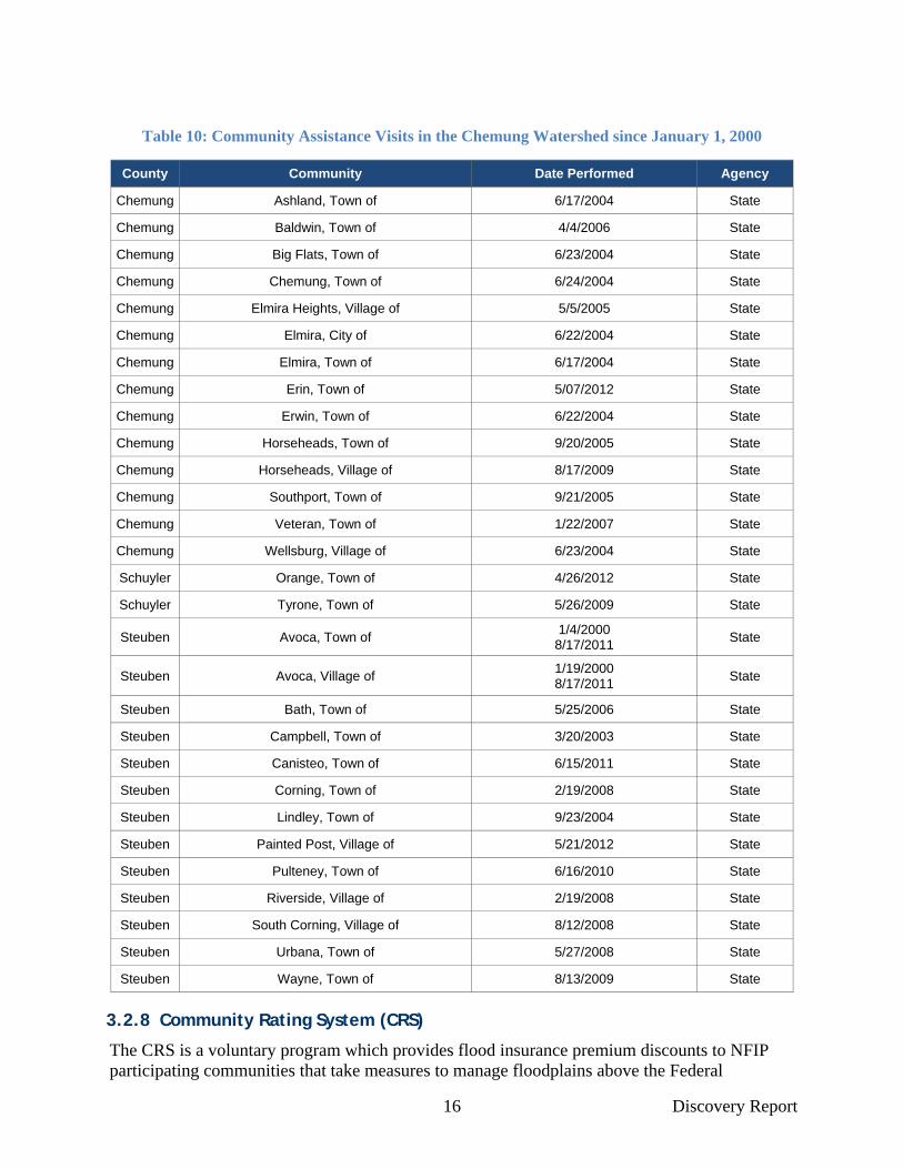
Statewide Community Assistance Visits (CAVs) are part of the evaluation and review process between FEMA and/or State NFIP Coordinator’s Offices with local officials to ensure that each community adequately enforces local floodplain management regulations to remain in compliance with NFIP requirements. CAVs are also a way for FEMA to provide technical assistance to communities. Table 10 (Page 16) lists all CAVs that occurred within the Chemung Watershed since January 1, 2000, all of which were performed by the State of New York, on behalf of FEMA.
16 Discovery Report
Table 10: Community Assistance Visits in the Chemung Watershed since January 1, 2000
County Community Date Performed Agency
Chemung Ashland, Town of 6/17/2004 State
Chemung Baldwin, Town of 4/4/2006 State
Chemung Big Flats, Town of 6/23/2004 State
Chemung Chemung, Town of 6/24/2004 State
Chemung Elmira Heights, Village of 5/5/2005 State
Chemung Elmira, City of 6/22/2004 State
Chemung Elmira, Town of 6/17/2004 State
Chemung Erin, Town of 5/07/2012 State
Chemung Erwin, Town of 6/22/2004 State
Chemung Horseheads, Town of 9/20/2005 State
Chemung Horseheads, Village of 8/17/2009 State
Chemung Southport, Town of 9/21/2005 State
Chemung Veteran, Town of 1/22/2007 State
Chemung Wellsburg, Village of 6/23/2004 State
Schuyler Orange, Town of 4/26/2012 State
Schuyler Tyrone, Town of 5/26/2009 State
Steuben Avoca, Town of 1/4/2000
8/17/2011 State
Steuben Avoca, Village of 1/19/2000 8/17/2011
State
Steuben Bath, Town of 5/25/2006 State
Steuben Campbell, Town of 3/20/2003 State
Steuben Canisteo, Town of 6/15/2011 State
Steuben Corning, Town of 2/19/2008 State
Steuben Lindley, Town of 9/23/2004 State
Steuben Painted Post, Village of 5/21/2012 State
Steuben Pulteney, Town of 6/16/2010 State
Steuben Riverside, Village of 2/19/2008 State
Steuben South Corning, Village of 8/12/2008 State
Steuben Urbana, Town of 5/27/2008 State
Steuben Wayne, Town of 8/13/2009 State
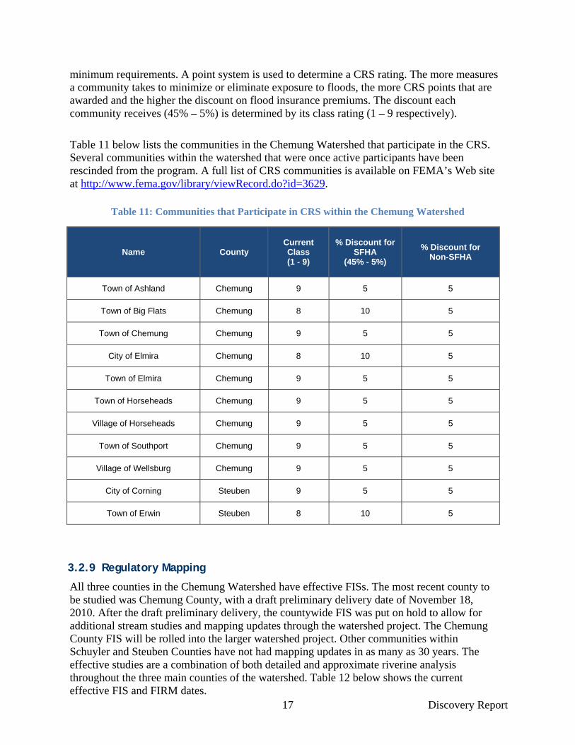
3.2.8 Community Rating System (CRS)
The CRS is a voluntary program which provides flood insurance premium discounts to NFIP participating communities that take measures to manage floodplains above the Federal
17 Discovery Report
minimum requirements. A point system is used to determine a CRS rating. The more measures a community takes to minimize or eliminate exposure to floods, the more CRS points that are awarded and the higher the discount on flood insurance premiums. The discount each community receives (45% – 5%) is determined by its class rating (1 – 9 respectively).
Table 11 below lists the communities in the Chemung Watershed that participate in the CRS. Several communities within the watershed that were once active participants have been rescinded from the program. A full list of CRS communities is available on FEMA’s Web site at http://www.fema.gov/library/viewRecord.do?id=3629.
Table 11: Communities that Participate in CRS within the Chemung Watershed
Name County Current Class (1 - 9)
% Discount for SFHA
(45% - 5%)
% Discount for Non-SFHA
Town of Ashland Chemung 9 5 5
Town of Big Flats Chemung 8 10 5
Town of Chemung Chemung 9 5 5
City of Elmira Chemung 8 10 5
Town of Elmira Chemung 9 5 5
Town of Horseheads Chemung 9 5 5
Village of Horseheads Chemung 9 5 5
Town of Southport Chemung 9 5 5
Village of Wellsburg Chemung 9 5 5
City of Corning Steuben 9 5 5
Town of Erwin Steuben 8 10 5
3.2.9 Regulatory Mapping
All three counties in the Chemung Watershed have effective FISs. The most recent county to be studied was Chemung County, with a draft preliminary delivery date of November 18, 2010. After the draft preliminary delivery, the countywide FIS was put on hold to allow for additional stream studies and mapping updates through the watershed project. The Chemung County FIS will be rolled into the larger watershed project. Other communities within Schuyler and Steuben Counties have not had mapping updates in as many as 30 years. The effective studies are a combination of both detailed and approximate riverine analysis throughout the three main counties of the watershed. Table 12 below shows the current effective FIS and FIRM dates.

18 Discovery Report
This information is presented in overview format on Discovery Map 2. The presentation of this information is not meant to replicate the effective FIRM information for Chemung Watershed Communities; it is presented to show a general picture of effective Special Flood Hazard Areas within the watershed. Effective SFHA mapping has been reviewed extensively by the Discovery project team to assist with the assessment of flood hazard mapping needs in the watershed. It has been noted through this assessment that there are sub-basin areas within the watershed that do not currently have mapped Special Flood Hazard Areas (SFHA). These areas have been noted and are being considered for new study dependent upon a comparative analysis of risk, including but not limited to: population density, critical facilities, and infrastructure. Other considerations are study needs and the availability of stream study related data.
Table 12: County Regulatory Mapping Status
County Mapping Status Effective Date
Chemung Draft Preliminary, Countywide Draft Preliminary on 11/18/2010
Steuben Effective, Community Based Dates ranging from 1977–2002
Schuyler Effective, Community Based Dates ranging from 1978–1988
3.2.10 Levees
FEMA’s Mid-term Levee Inventory (MLI) contains information on hundreds of levee, floodwall, and closure structures in New York State. The information for these flood control structures are gathered from the most recent available data sources including the National Levee Database (NLD, maintained by the USACE), other federal agencies, state organizations, and community officials. There are several levee/floodwall structures within the Chemung Watershed which are displayed on the Discovery map. It should be noted that the Discovery maps only display the engineered structure centerlines. In several instances, closure structures, natural high ground, and/or infrastructure such as highway embankments may appear as ‘gaps’ in the structure, where there is continuity in the flood control system. A list of the communities affected by these flood protection systems can be found below:
Town and Village of Avoca Town and Village of Bath Town and City of Corning Town and City of Elmira Town of Erwin Town of Horseheads (structure extends slightly into the Village of Horseheads) Village of Painted Post Village of Riverside Village of South Corning Town of Southport Village of Wellsburg (not shown in Discovery maps)
These communities and/or the levee owners will need to submit proper documentation to meet the data requirements provided in Title 44 of the Code of Federal Regulations Section 65.10 (44 CFR 65.10) for levee accreditation. Levees that are not accredited will be evaluated under FEMA’s new levee flood hazard mapping and modeling approach, which will replace the current “without levee approach” and ultimately provide a more precise assessment of flood

19 Discovery Report
risk in areas affected by levees. As the new modeling methodologies will likely affect any hydraulic modeling in the vicinity of these non-accredited structures, FEMA will temporarily withhold issuance of flood risk determinations for communities affected by non-accredited levees until the new methodologies have been finalized. This temporary delay will allow FEMA to give proper consideration to levees under the new modeling procedures. A tentative date for finalizing and moving forward with the new modeling guidelines has not yet been established.
Letters were disseminated directly to the levee communities that were represented at the Discovery meeting that included three options each community can pursue with regards to the treatment of levees: no action, provisional accreditation, or full accreditation. Also distributed was a FEMA fact sheet on the new analysis guidelines, criteria for accreditation, mapping requirements, and frequently asked questions (Appendix E). Other levee communities in the watershed that were not represented at the meetings were mailed the same letters. Additional coordination with these communities will be necessary to ensure understanding of the mapping requirements for levees and to prepare the residents for the possibility that the levees will not be shown as providing protection from the base flood.
3.2.11 Dams
The Chemung Watershed includes 149 dam structures, according to the NYSDEC statewide inventory. NYSDEC uses a classification scale of A-D and 0 to assign hazard potential to each of the dam structures contained within the inventory. Out of the 149 dams within the Chemung Watershed, 115 are classified as having at least a low hazard potential in accordance with this scale. A detailed description of the NYSDEC hazard classification system can be found below:
Class A-Low Hazard Potential: Resulting damages from a dam failure would likely be minimal and not interfere with any critical infrastructure; personal injury and substantial economic loss is unlikely to occur (Class A dams are not included in the Discovery Map).
Class B-Intermediate Hazard Potential: A dam failure may result in damage to isolated homes, roads and railways; critical facilities may experience disruption; personal injury or substantial economic loss is likely, but loss of human life is not expected.
Class C-High Hazard Potential: Dam failure may result in widespread or serious damage to homes; damage to roads, railroads, commercial buildings and critical infrastructure is expected; such that loss of human life and substantial economic loss is expected.
Class D-Negligible or No Hazard Potential: Dam has been breached or removed or otherwise no longer material impounds waters, or the dam was planned but never constructed here (Class D dams are not included in the Discovery Map).
Class 0-Unclassified Hazard Potential: Hazard code has not yet been assigned.

20 Discovery Report
Based on the NYSDEC classification system, the 115 dams within the Chemung Watershed were reclassified to the following scale to be consistent with FEMA 333: Federal Guidelines for Dam Safety: Hazard Potential Classification System for Dams (2005):
Class 1-Low Hazard Potential: Dam failure results in no probable loss of human life and insignificant economic and/or environmental losses (Class A NYSDEC Dams).
Class 2-Significant Hazard Potential: Dam failure results no probable loss of human life but can cause economic loss, environmental damage, disruption of lifeline facilities, or can impact other concerns (Class B NYSDEC Dams).
Class 3-High Hazard Potential: Failure or mis-operation will likely cause loss of human life (Class C NYSDEC Dams).
Unclassified Hazard Potential: Hazard potential undetermined (Class 0 NYSDEC Dams).
Based on this hazard classification scale, there are a total of 14 dams classified as having at least a significant hazard potential (Class 2 and 3) within the Chemung Watershed. These dams are listed in Table 13 below and are shown on Discovery Map 1.
Table 13: Hazard Codes of Dams in the Chemung Watershed
Name Alternate Name Year Constructed
NYSDEC Hazard Classification
(B/C) FEMA Hazard Classification
Williams Pond Dam 1996 B Class 2
Elmira Reformatory Dam 1870 B Class 2
Corning Community College Dam 1963 B Class 2
Arthur Flick Dam Tanglewood Lake Dam 1976 B Class 2
Waverly Lower Reservoir Dam 1880 C Class 3
Beecher Creek Flood Control Dam 1999 C Class 3
Upper Larchmont Road Dam 2005 C Class 3
Hoffman Creek Dam West Hill (Elmira) Reservoir
1871 C Class 3
Newtown Hoffman Site 18 Dam Harris Hill Dam 1978 C Class 3
Newtown Hoffman Site 1 Dam Marsh Dam 1976 C Class 3
Newtown Hoffman Site 12e Dam Sullivanville Dam 1989 C Class 3
Newtown Hoffman Site 5a Dam Jackson Creek Dam 1999 C Class 3
Newtown Hoffman Site 3a Dam Park Station 1976 C Class 3
Tyrone Power Company Dam Green Valley Lake 1953 C Class 3
3.2.12 Disaster Declarations
Table 14 (Page 21) lists all disaster declarations within the Chemung Watershed since 1970. Within the three counties, 10 flood-related disasters have been declared since that time. FEMA’s disaster declaration history for New York State is available at: http://www.fema.gov/news/disaster_totals_annual.fema

21 Discovery Report
Table 14: Disaster Declarations in the Chemung Watershed
Date Type Affected County Action
Jun-2011 Flooding, Tornadoes, Wind Chemung, Steuben President's Declaration of Major
Disaster
Oct-2004 Tropical Depression Ivan Steuben President's Declaration of Major
Disaster
Oct-2004 Severe Storms, Flooding Steuben President's Declaration of Major
Disaster
Aug-2004 Severe Storms, Flooding Steuben President's Declaration of Major
Disaster
Aug-2003 Tornadoes, Flooding Chemung, Schuyler,
Steuben President's Declaration of Major
Disaster
Jul-2000 Severe Storms Steuben President's Declaration of Major
Disaster
Jul-1998 Severe Storms, Flooding Steuben President's Declaration of Major
Disaster
Dec-1996 Severe Storms, Flooding Chemung, Schuyler,
Steuben President's Declaration of Major
Disaster
Jan-1996 Severe Storms, Flooding Chemung, Steuben President's Declaration of Major
Disaster
Mar-1991 Severe Storm, Winter Storm Steuben President's Declaration of Major
Disaster
Sep-1984 Severe Storms, Flooding Steuben President's Declaration of Major
Disaster
Jun-1976 Flash Flooding Chemung, Steuben President's Declaration of Major
Disaster
Jun-1972 Tropical Storm Agnes Chemung, Schuyler,
Steuben President's Declaration of Major
Disaster
Jul-1970 Heavy Rains, Flooding Schuyler President's Declaration of Major
Disaster
3.2.13 Stream Gages
The USGS National Water Information System Web Interface (http://waterdata.usgs.gov/nwis/rt) provides real-time data for any given USGS sponsored stream gage location. Table 15 below shows the gage identification number, location, drainage area, status, and county for all USGS gages relevant to the Chemung Watershed with a historical period of record greater than 10 years. Gage locations are also illustrated in Figure 5 (Page 22).
Table 15: USGS Stream Gage Information
Site Number
Gage Location Drainage Area
(SqMi) Gage Status County
01526500 TIOGA RIVER NEAR ERWINS NY 1377 Active Steuben
01527000 COHOCTON RIVER AT COHOCTON NY 52.2 Inactive Steuben
01527500 COHOCTON RIVER AT AVOCA NY 152 Active Steuben
01528000 FIVEMILE CREEK NEAR KANONA NY 66.8 Inactive Steuben
01529000 MUD CREEK NEAR SAVONA NY 76.6 Inactive Steuben
01529500 COHOCTON RIVER NEAR CAMPBELL NY 470 Active Steuben
01529950 CHEMUNG RIVER AT CORNING NY 2005 Active Steuben
01530332 CHEMUNG RIVER AT ELMIRA NY 2162 Active Chemung
01530500 NEWTOWN CREEK AT ELMIRA NY 77.5 Inactive Chemung
01531000 CHEMUNG RIVER AT CHEMUNG NY 2506 Active Chemung

22 Discovery Report
Figure 5: Locations of USGS Stream Gages within the Watershed
Historical stream flow information from the USGS gages listed in Table 15 will be employed for use in hydrological analysis where it is determined to be applicable. Locally owned and operated rainfall gages are present throughout the watershed. FEMA will utilize information from these gages in developing meteorological models for the study watersheds that will employ rainfall-runoff models and calibration.
3.2.14 Additional Data Requested
In addition to the aforementioned, the Discovery team requested a variety of other data that may be useful for the Discovery process and the Chemung Watershed Project in general. These requests included building footprints, parcel and tax data, Emergency Action Plans, as-built drawings for bridges and culverts, design books for community dams, watershed plans, land use regulations, flood control structure information, and any hydrologic or hydraulic data. With watershed stakeholder guidance and assistance, the Discovery team has been able to obtain a substantial amount of information in the months following the Discovery meetings in May 2011:
Study of Stormwater Drainage Problems Within the Hoffman Brook Watershed, City of Elmira, NY, 1997
23 Discovery Report
o This information will assist with elevation-storage-discharge data for Hoffman Creek dams
Conveyance of Stormwater From Werts Creek to Coleman Avenue, October, 2011
o This information will be useful if Werts Creek is included in the final scope of work
NRCS Bentley Creek PL-566 Watershed Plan
o Plan contains hydrologic and hydraulic information that will be utilized for Bentley Creek model calibration if data meets FEMA specifications
Hydrologic TR-20 Rainfall-runoff data will be checked against regression equation discharges per FEMA Guidelines and Specifications
Hydraulic data in the NRCS plan utilized ‘aerial survey’ for cross sections. FEMA Guidelines and Specifications require field survey of cross sections for detailed studied streams. However, the NRCS survey information could be used to supplement areas of a new hydraulic model on Bentley Creek for enhanced accuracy
NRCS reservoir and dam data; design sheets, Operation and Maintenance Plans, as-built documents
o This information can potentially be used to check dam related data for H&H modeling; e.g. spilllways elevation, stage-storage-discharge data, operation plans, outlet structure geometry/rating curves
NYSDOT bridge/culvert data and hydraulic modeling
o May be useful if there are issues with survey data or where survey data was not obtained.
USACE levee and floodwall centerline (3D), closure structure, and cross sections GIS data from the National Levee Database for all of Baltimore District's levee projects in New York State
o Will ensure completeness of flood control structure dataset

24 Discovery Report
4 Discovery Meeting The Discovery team met with the local communities in the Chemung Watershed on May 4, 5, and 6 of 2011. Four Discovery meetings were held over these 3 days to accommodate the schedules of local stakeholders to the best extent possible. Two meetings were held in Horseheads, NY, and two were held in Bath, NY. Most of the meetings were relatively well attended, with 25, 2, 15, and 30 attendees present, respectively. Many county, state, and federal organizations were represented, including the Chemung County Soil & Water Conservation District (SWCD), County Emergency Management and Planning Departments from all 3 counties, the Susquehanna River Basin Commission (SRBC), FEMA, New York State Department of Environmental Conservation (NYSDEC), New York State Department of Transportation, Southern Tier Central Regional Planning and Development Board (STCRPDB) , National Resources Conservation Service (NRCS), and the United States Army Corps of Engineers (USACE), as well as many other county and community officials. During the meetings, community maps displaying geospatial datasets and flood hazard information were reviewed and interviews were conducted to determine current flood hazards and risks for each community. Information packets were disseminated to all communities, and an overview of the Risk MAP program was presented.
During the Discovery Meetings, officials referred to local hazard mitigation plans as a source of information pertaining to historical and persisting flooding concerns within the Chemung Watershed. A review of these documents and the community interviews concluded that the main concerns of the communities are areas of recurring flooding throughout the watershed and perceived outdated or incorrect SFHAs. Several streams throughout the watershed were identified as areas that needed new or updated studies and special attention for consideration in the final scope of the Chemung Watershed Risk MAP project.
Community officials in Steuben County identified Meads Creek as a top priority and the Town of Campbell expressed that a detailed study is needed for the Cohocton River. Repeated flash flooding occurs along Meads Creek, and, in 2003, flash flooding caused both Interstate 86 and State Route 415 to close. Upstream of Steuben County, Meads Creek has caused flooding issues in Schuyler County where erosion has contributed to restricted flows as a result of sediment accumulation. High water levels have contributed to flooding outside of mapped SFHAs and have damaged a bridge on Coon Hollow Road in the Town of Orange.
In Steuben County, both Meads Creek and the Cohocton River caused severe flood events as a result of the “Finger Lakes Flood” of 1935 and after intense rainfall on previously saturated ground in 1946. Hurricanes Agnes, Eloise, and Beryl caused major flooding issues along these streams, and other flooding events have occurred as a result of snow melt, ice jams, and local drainage issues. Flooding along these streams has adversely impacted floodplain and floodway development, including homes and businesses.
Local officials in Steuben County also expressed concern about the Cohocton and Chemung Rivers in the Village of Painted Post. As a result of new highway construction, several additional bridges have been built over these streams, and it was stated that the hydraulic effects from the structures need to be taken into account. The Town of Bath believes the
25 Discovery Report
stretch of Five Mile Creek upstream in the Town of Wheeler should be studied using detailed methods (Zone AE). Another area of flooding concern is the northeast bank of the confluence of Five Mile Creek and the Cohocton River in the Hamlet of Kanona (Town of Bath). Over half of floodplain development in this area is located in the floodway of the Cohocton River. The reaches of Campbell Creek in the Town of Bath may have an understated flood hazard area, as might Meads Creek in the Town of Erwin near Victory Village and Colonial Coach mobile home parks, as well as the area near State Route 415 and the Corning-Painted Post airport.
The Town of Ashland, in Chemung County, has struggled with flooding issues affecting around 50 structures on State Route 427 along the Chemung River floodplain. This area was significantly flooded in 1972, 1994, and 1996. Some areas of State Route 427 have faced additional complications as a result of diverted floodwater from Seeley Creek. Flash flooding along Seeley Creek has negatively impacted development in low-lying areas of its floodplain. In 2011, after the effects Tropical Storms Irene and Lee, Newtown and Bentley Creek both caused major problems in Horseheads and Wellsburg within Chemung County, with local drainage issues exacerbating the flooding effects.
At the end of the meeting, evaluation forms were given to those in attendance to gauge the effectiveness of the information presented at the meeting. This form is included as Appendix F. The input and data gathered at these meetings provided the basis for the Discovery process and will be considered as the watershed study moves forward.
All locally identified flood hazard mapping requests will be fully considered before the scope of work is fully established for the Chemung Watershed Risk MAP project. While all areas of concern will not be able to be addressed with new studies, this project will provide newer and more accurate flood risk identification and information for a great number of communities within the Chemung Watershed. Priorities for new stream studies will be established based on risk (population & infrastructure), the availability of existing data that can be leveraged, and community identified needs.

26 Discovery Report
5 References Federal Emergency Management Agency, Community Rating System (CRS) Communities and
their Classes. October 2010. Available at http://www.fema.gov/library/viewRecord.do?id=3629.
Federal Emergency Management Agency. Mapping Information Platform (MIP). Accessed March 23, 2011. http://msc.fema.gov/.
Federal Emergency Management Agency. Mid-term Levee Inventory. (Database not public yet.)
Federal Emergency Management Agency. National Flood Hazard Layer. https://hazards.fema.gov/wps/portal/mapviewer Accessed March 23, 2011.
Federal Emergency Management Agency. Treatment of Levees in Flood Risk Studies. Published March 11, 2011.
Interviews with watershed Community Officials, Town of Horseheads, New York. May 24–26, 2011.
Southern Tier Central Regional Planning and Development Board. Susquehanna-Chemung Action Plan Draft Goals. June 29, 2011.
Southern Tier Central Regional Planning and Development Board. Flood Mitigation Action Plan, Schuyler County, NY. October 1999. http://www.stcplanning.org/usr/Program_Areas/Hazard_Mitigation/Flood_Mit_Plan_Schuyler_1999.pdf. Accessed June 15, 2011.
Southern Tier Central Regional Planning and Development Board. Steuben County Comprehensive Emergency Operations Plan. June 2009. http://www.steubencony.org/emo/hazardmit/cover.pdf. Accessed June 15, 2011.
Southern Tier Central Regional Planning and Development Board. Reducing Flood Damage in the Southern Tier Central Region. May, 1998. http://www.stcplanning.org/usr/Program_Areas/Flood_Mitigation/STC_Flood_Strategy_1998.pdf. Accessed June 15, 2011.
U.S. Department of the Interior, Geological Survey, Water Resources Data for New York, Surface Water Records, Albany, New York, published annually.
U.S. Geological Survey. National Hydrography Dataset (NHD). http://nhd.usgs.gov/. Accessed June 15, 2011.
U.S. Geological Survey. USGS National Water Information System Web Interface. Accessed June 15, 2011. http://waterdata.usgs.gov/nwis/rt.


