24
CALTRANS district 3
Page 2
STATE ROUTE 174 transportation concept report
Page 3
TABLE OF CONTENTS
About the Transportation Concept Report……………………………………………………………………………4
TCR Purpose…………………………………………………………………………………………………………………………5
Stakeholder Participation…………………………………………………………………………………………………….5
State and Local Responsibility……………………………………………………………………………………………..5
Strategic Management and Performance…………………………………………………………………………… 5
State Route 174 Corridor Summary…………………………………………………………………………………….6
Key Corridor Issues…………………………………………………………………………………………………………….6
State Route 174 Segmentation Map…………………………………………………………………………………..7
Economic Drivers and Traffic Generators…………………………………………………………………………..8
Route Designations…………………………………………………………………………………………………………….8
Multi-Modal Considerations……………………………………………………………………………………………...8
System Characteristics, Concept Facility and Corridor Performance………………………………….10
Environmental Considerations………………………………………………………………………………………….12
Bicycle, Pedestrian, Transit Facilities, Rideshare, Park and Ride……………………………………….13
Freight Infrastructure and the California Sustainable Freight Action Plan………………………...14
State Highway Operation and Protection Program (SHOPP) Asset Management……………...15
State Route 174 Segments……………………………………………………………………………………………….16
State Route 174 Segment 1 Summary……………………………………………………………………….17
State Route 174 Segment 2 Summary……………………………………………………………………….18
State Route 174 Segment 3 Summary………………………………………………………………………..19
State Route 174 Segment 4 Summary……………………………………………………………………….21
CALTRANS district 3
Page 4
ABOUT THE TRANSPORTATION CONCEPT REPORT
System Planning is the long-range transportation planning process for the California Department of Transportation (Caltrans). The System Planning process fulfills Caltrans’ statutory responsibility as owner/operator of the State Highway System (SHS) (Gov. Code §65086) by evaluating conditions and proposing enhancements to the SHS. Through System Planning, Caltrans focuses on developing an integrated multimodal transportation system that meets Caltrans’ goals of safety, mobility, delivery, stewardship, and service.
The System Planning process is primarily composed of four parts: the District System Management and Development Plan (DSMDP), the Transportation Concept Report (TCR), the Corridor System Management Plan (CSMP), and the DSMDP Project List. The district-wide DSMDP is a strategic policy and planning document that focuses on maintaining, operating, managing, and developing the transportation system. The TCR is a planning document that identifies the existing and future route conditions as well as future needs for each route on the SHS. The CSMP is a complex, multi-functional, multi-jurisdictional planning document that identifies future needs within corridors experiencing or expected to experience high levels of congestion. The CSMP serves as a TCR for segments covered by the CSMP. The District System Management Plan (DSMP) Project List is a list of partially programmed, planned and conceptual transportation projects used to recommend projects for funding.
District 3 System Planning continues its efforts to streamline and expedite short-range to long-range project needs by creating focused documents such as:
The District 3 State Highway Bicycle Facility Plan (SHBFP) is a comprehensive plan that identifies a vision and framework for bicycle facility improvements on the SHS in District 3. It provides information regarding bicycling on the SHS along with recommended changes to improve connectivity and convenience.
The Intelligent Transportation Systems and Operations Plan (ITS/Ops Plan) provides critical guidance to optimize the State Highway System within the District by identifying and managing ITS and other operational strategies that yield a high return on investment. The ITS/Ops Plan identifies an inventory of prioritized projects and a process for continuously updating the inventory.
The District 3 Goods Movement Study is a district-wide gap analysis of the district goods movement network, proposing methodologies to identify and prioritize freight projects. Findings and recommendations from this study will inform local, regional, and statewide planning efforts
The district is in the process of developing a Complete Streets Plan that will assess existing conditions and opportunities to identify, and implement complete streets enhancements to be included in transportation improvement projects on the SHS corridors.
These System Planning products are also intended as resources for stakeholders, regional, local and partner agencies, and the public. This TCR includes projects identified in the previously discussed focused documents. For more information and to access all System Planning products, please visit :
http://www.dot.ca.gov/dist3/departments/planning/systemplanning.htm.
STATE ROUTE 174 transportation concept report
Page 5
TCR PURPOSE
California’s SHS needs long range planning documents to guide the logical development of transportation systems as required by CA Gov. Code §65086 and as necessitated by the public, stakeholders, and system users. The purpose of the TCR is to evaluate current and projected conditions along the route and communicate the vision for the development of each route in each Caltrans District during a 20-year planning horizon. The TCR is developed with the goals of increasing safety, improving mobility, providing excellent stewardship, and meeting community and environmental needs along the corridor through integrated management of the transportation network, including the highway, transit, pedestrian, bicycle, freight, operational improvements and travel demand management components of the corridor.
STAKEHOLDER PARTICIPATION
Stakeholder participation was sought throughout the development of the TCR for State Route (SR) 174. Outreach efforts involved internal and external stakeholders, and regional and local agencies. During the initial information resource gathering for the TCR, stakeholders were contacted for initial input related to their particular specializations, and to verify data sources used and data accuracy. As the document was finalized, stakeholders were asked to review the document for comments, edits, and for consistency with the intent of existing plans, policies, and procedures. Written comments were received and incorporated into the final document. The process of including and working closely with stakeholders adds value to the TCR, allows for outside input, provides an opportunity for ideas to be reflected in the document, increases credibility, and helps strengthen public support and trust.
STATE AND LOCAL RESPONSIBILITY
Improvements to the SHS are the responsibility of both Caltrans and local agencies. However, with responsibility comes opportunity to leverage funding sources and collaborate on projects in a more holistic manner that benefits both entities. Developments that add cumulative impacts to this route and the regional State Highway System may necessitate that local jurisdictions provide nexus based, proportional fair-share funding for future highway improvements. Developments or local circulation changes that will have significant traffic impacts to the highway should provide improvements to mitigate those impacts.
Caltrans will continue to monitor and analyze programs and projects to incorporate complete streets and sustainability elements into existing and new projects. Projects that will implement complete streets and sustainability elements are identified in the project list under the “objective” column.
STRATEGIC MANAGEMENT AND PERFORMANCE
The Department’s Strategic Management Plan is the road map of Caltrans’ role, expectations, and activities; and includes performance measures to bring about transparency, accountability, sustainability, and innovation. The Plan highlights the Department goals which are: Safety and Health, Stewardship and Efficiency, Sustainability, Livability and Economy, System Performance, and Organizational Excellence.
CALTRANS district 3
Page 6
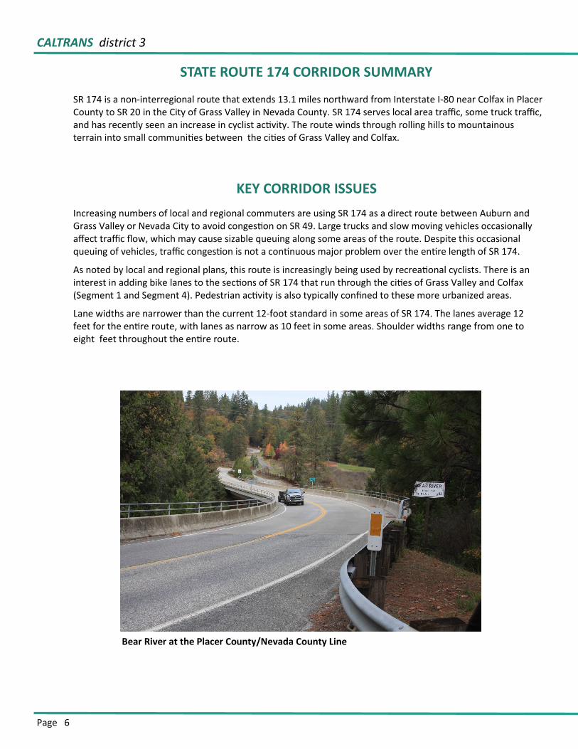
STATE ROUTE 174 CORRIDOR SUMMARY
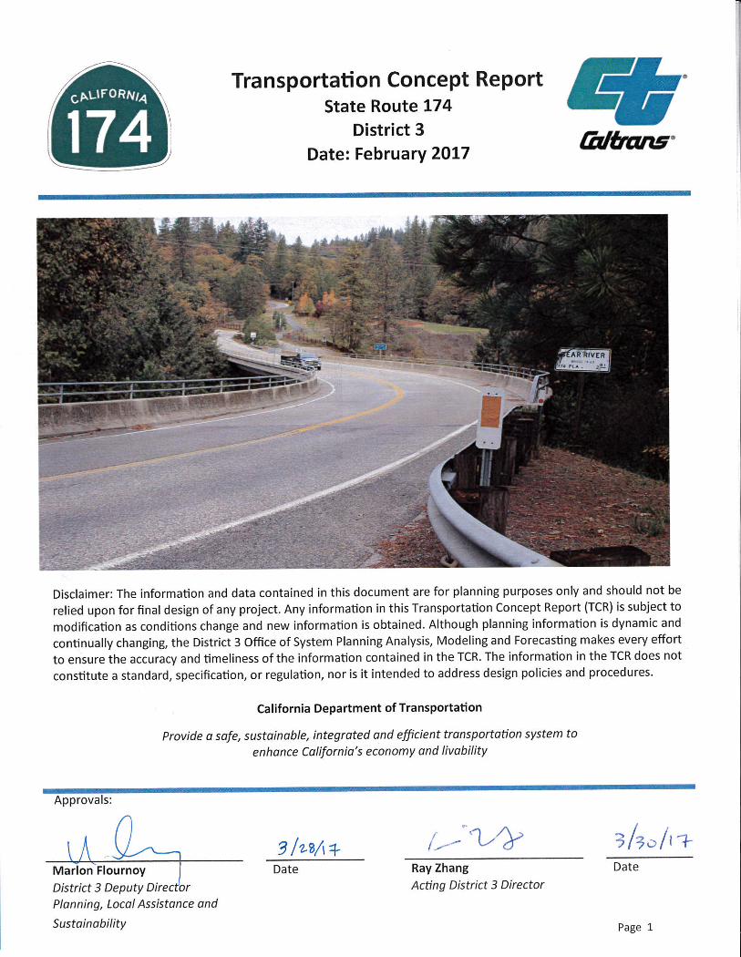
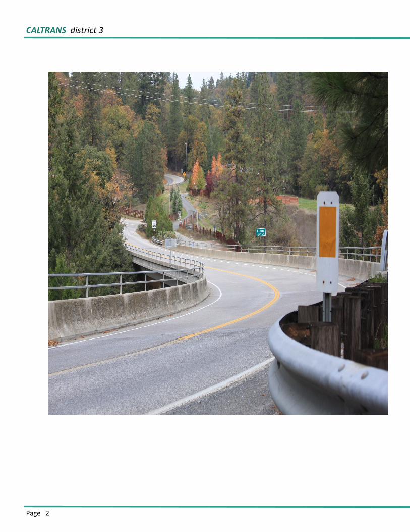
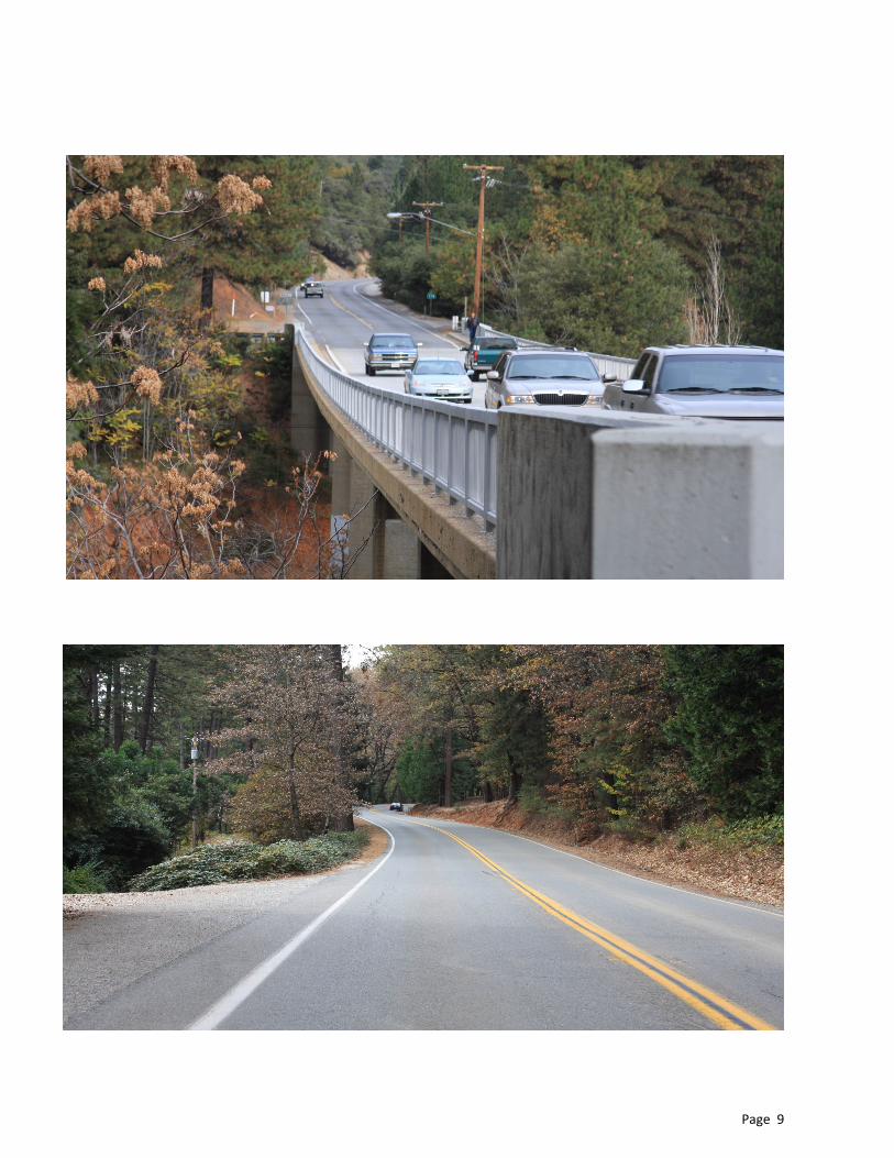
SR 174 is a non-interregional route that extends 13.1 miles northward from Interstate I-80 near Colfax in Placer County to SR 20 in the City of Grass Valley in Nevada County. SR 174 serves local area traffic, some truck traffic, and has recently seen an increase in cyclist activity. The route winds through rolling hills to mountainous terrain into small communities between the cities of Grass Valley and Colfax.
KEY CORRIDOR ISSUES
Increasing numbers of local and regional commuters are using SR 174 as a direct route between Auburn and Grass Valley or Nevada City to avoid congestion on SR 49. Large trucks and slow moving vehicles occasionally affect traffic flow, which may cause sizable queuing along some areas of the route. Despite this occasional queuing of vehicles, traffic congestion is not a continuous major problem over the entire length of SR 174.
As noted by local and regional plans, this route is increasingly being used by recreational cyclists. There is an interest in adding bike lanes to the sections of SR 174 that run through the cities of Grass Valley and Colfax (Segment 1 and Segment 4). Pedestrian activity is also typically confined to these more urbanized areas.
Lane widths are narrower than the current 12-foot standard in some areas of SR 174. The lanes average 12 feet for the entire route, with lanes as narrow as 10 feet in some areas. Shoulder widths range from one to eight feet throughout the entire route.
Bear River at the Placer County/Nevada County Line
STATE ROUTE 174 transportation concept report
Page 7
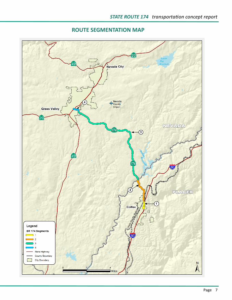
ROUTE SEGMENTATION MAP
CALTRANS district 3
Page 8
Economic Drivers and Traffic Generators
Trip generators include recreational areas such as Empire Mine State Historic Park in Grass Valley and Rollins Lake on the Bear River at the boundary of Placer and Nevada Counties.
Route Designations
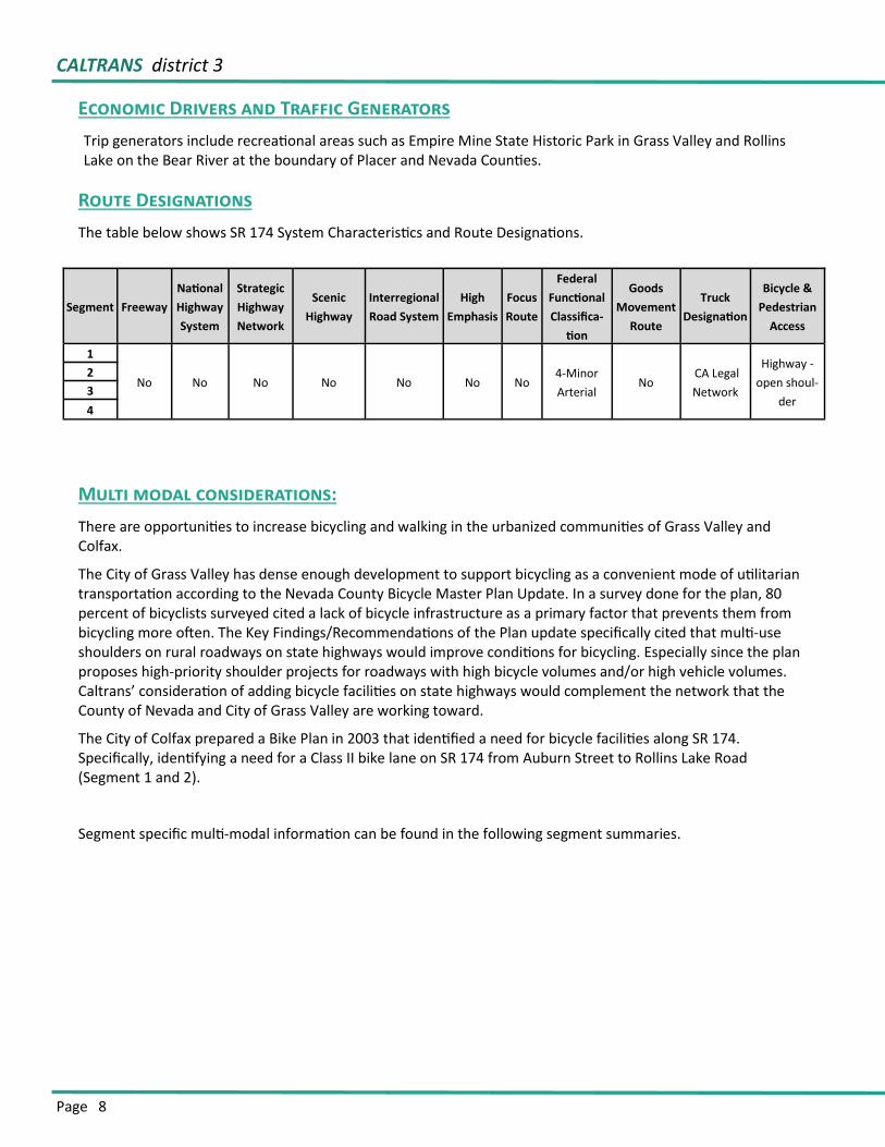
The table below shows SR 174 System Characteristics and Route Designations.
Multi modal considerations:
There are opportunities to increase bicycling and walking in the urbanized communities of Grass Valley and Colfax.
The City of Grass Valley has dense enough development to support bicycling as a convenient mode of utilitarian transportation according to the Nevada County Bicycle Master Plan Update. In a survey done for the plan, 80 percent of bicyclists surveyed cited a lack of bicycle infrastructure as a primary factor that prevents them from bicycling more often. The Key Findings/Recommendations of the Plan update specifically cited that multi-use shoulders on rural roadways on state highways would improve conditions for bicycling. Especially since the plan proposes high-priority shoulder projects for roadways with high bicycle volumes and/or high vehicle volumes. Caltrans’ consideration of adding bicycle facilities on state highways would complement the network that the County of Nevada and City of Grass Valley are working toward.
The City of Colfax prepared a Bike Plan in 2003 that identified a need for bicycle facilities along SR 174. Specifically, identifying a need for a Class II bike lane on SR 174 from Auburn Street to Rollins Lake Road (Segment 1 and 2).
Segment specific multi-modal information can be found in the following segment summaries.
Segment Freeway
National
Highway
System
Strategic
Highway
Network
Scenic
Highway
Interregional
Road System
High
Emphasis
Focus
Route
Federal
Functional
Classifica-
tion
Goods
Movement
Route
Truck
Designation
Bicycle &
Pedestrian
Access
1
No No No No No No No 4-Minor
Arterial No
CA Legal
Network
Highway -
open shoul-
der
2
3
4
Page 9
CALTRANS district 3
Page 10
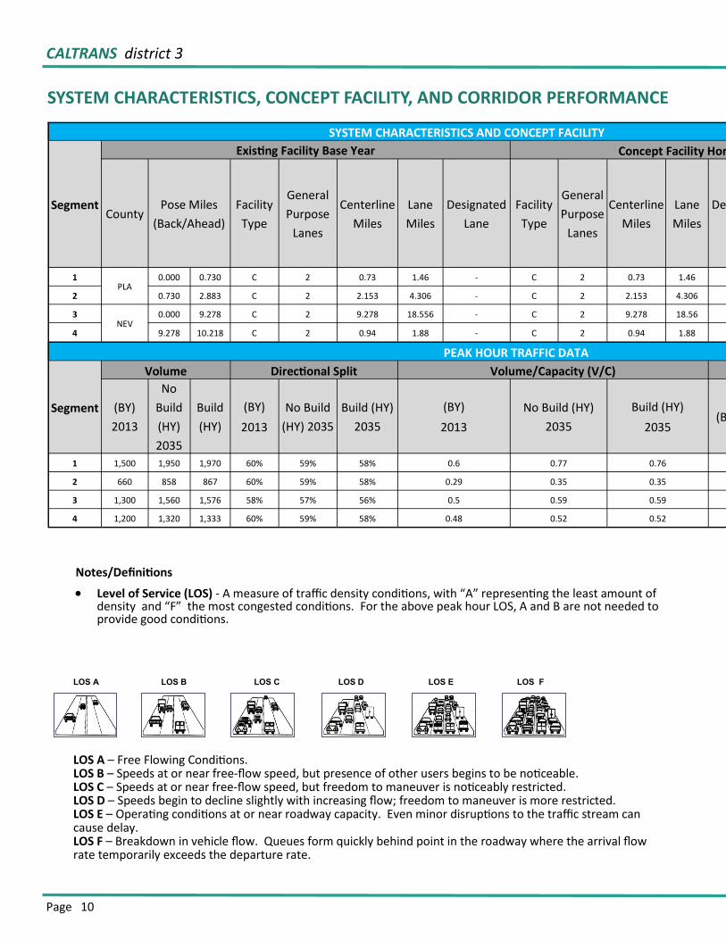
SYSTEM CHARACTERISTICS, CONCEPT FACILITY, AND CORRIDOR PERFORMANCE
LOS A – Free Flowing Conditions. LOS B – Speeds at or near free-flow speed, but presence of other users begins to be noticeable. LOS C – Speeds at or near free-flow speed, but freedom to maneuver is noticeably restricted. LOS D – Speeds begin to decline slightly with increasing flow; freedom to maneuver is more restricted. LOS E – Operating conditions at or near roadway capacity. Even minor disruptions to the traffic stream can cause delay. LOS F – Breakdown in vehicle flow. Queues form quickly behind point in the roadway where the arrival flow rate temporarily exceeds the departure rate.
LOS A LOS B LOS C LOS D LOS E LOS F
SYSTEM CHARACTERISTICS AND CONCEPT FACILITY
Segment
Existing Facility Base Year Concept Facility Horizon Year
County Pose Miles
(Back/Ahead)
Facility
Type
General
Purpose
Lanes
Centerline
Miles
Lane
Miles
Designated
Lane
Facility
Type
General
Purpose
Lanes
Centerline
Miles
Lane
Miles
Designated
Lane
1 PLA
0.000 0.730 C 2 0.73 1.46 - C 2 0.73 1.46
2 0.730 2.883 C 2 2.153 4.306 - C 2 2.153 4.306
3 NEV
0.000 9.278 C 2 9.278 18.556 - C 2 9.278 18.56
4 9.278 10.218 C 2 0.94 1.88 - C 2 0.94 1.88
PEAK HOUR TRAFFIC DATA
Segment
Volume Directional Split Volume/Capacity (V/C)
(BY)
2013
No
Build
(HY)
2035
Build
(HY)
(BY)
2013
No Build
(HY) 2035
Build (HY)
2035
(BY)
2013
No Build (HY)
2035
Build (HY)
2035 (BY) 2013
1 1,500 1,950 1,970 60% 59% 58% 0.6 0.77 0.76
2 660 858 867 60% 59% 58% 0.29 0.35 0.35 1,308
3 1,300 1,560 1,576 58% 57% 56% 0.5 0.59 0.59 7,634
4 1,200 1,320 1,333 60% 59% 58% 0.48 0.52 0.52 1,057
Notes/Definitions
Level of Service (LOS) - A measure of traffic density conditions, with “A” representing the least amount of density and “F” the most congested conditions. For the above peak hour LOS, A and B are not needed to provide good conditions.
STATE ROUTE 174 transportation concept report
Page 11
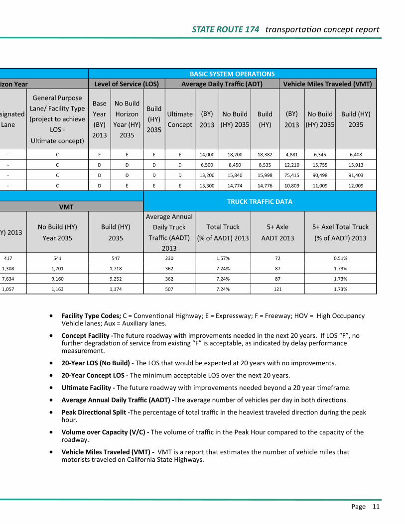
BASIC SYSTEM OPERATIONS
Concept Facility Horizon Year Level of Service (LOS) Average Daily Traffic (ADT) Vehicle Miles Traveled (VMT)
Designated
Lane
General Purpose
Lane/ Facility Type
(project to achieve
LOS -
Ultimate concept)
Base
Year
(BY)
2013
No Build
Horizon
Year (HY)
2035
Build
(HY)
2035
Ultimate
Concept
(BY)
2013
No Build
(HY) 2035
Build
(HY)
(BY)
2013
No Build
(HY) 2035
Build (HY)
2035
- C E E E E 14,000 18,200 18,382 4,881 6,345 6,408
- C D D D D 6,500 8,450 8,535 12,210 15,755 15,913
- C D D D D 13,200 15,840 15,998 75,415 90,498 91,403
- C D E E E 13,300 14,774 14,776 10,809 11,009 12,009
TRUCK TRAFFIC DATA VMT
(BY) 2013 No Build (HY)
Year 2035
Build (HY)
2035
Average Annual
Daily Truck
Traffic (AADT)
2013
Total Truck
(% of AADT) 2013
5+ Axle
AADT 2013
5+ Axel Total Truck
(% of AADT) 2013
417 541 547 230 1.57% 72 0.51%
1,308 1,701 1,718 362 7.24% 87 1.73%
7,634 9,160 9,252 362 7.24% 87 1.73%
1,057 1,163 1,174 507 7.24% 121 1.73%
Facility Type Codes; C = Conventional Highway; E = Expressway; F = Freeway; HOV = High Occupancy Vehicle lanes; Aux = Auxiliary lanes.
Concept Facility -The future roadway with improvements needed in the next 20 years. If LOS “F”, no further degradation of service from existing “F” is acceptable, as indicated by delay performance measurement.
20-Year LOS (No Build) - The LOS that would be expected at 20 years with no improvements.
20-Year Concept LOS - The minimum acceptable LOS over the next 20 years.
Ultimate Facility - The future roadway with improvements needed beyond a 20 year timeframe.
Average Annual Daily Traffic (AADT) -The average number of vehicles per day in both directions.
Peak Directional Split -The percentage of total traffic in the heaviest traveled direction during the peak hour.
Volume over Capacity (V/C) - The volume of traffic in the Peak Hour compared to the capacity of the roadway.
Vehicle Miles Traveled (VMT) - VMT is a report that estimates the number of vehicle miles that motorists traveled on California State Highways.
Page 12
ENVIRONMENTAL CONSIDERATIONS
SAFETEA-LU Section 6001 and MAP-21 requires environmental considerations in the development of long-range transportation plans. To comply, environmental issues within the corridor are considered by describing the existing environmental setting, consulting with resource agencies, considering possible corridor development constraints, and discussing potential avoidance, minimization, and mitigation. Including environmental considerations will help streamline project initiation and delivery, aid decision makers, and inform stakeholders.
Wildlife crossings are areas of concentrated animal movement intercepted by roadways. In most cases, effects are seen because animals are inadvertently hit by drivers as they attempt to cross the road surface, leading to mortality of animals (“road-kill”) and safety concerns to the motoring public. In other cases, animals choose to avoid crossing, and the roads present barriers to animal movement, dividing a formerly single population into two or more isolated population segments, causing a range of negative effects. These effects may be less apparent, but are no less significant. Further, environmental regulations compel transportation professionals to reduce or eliminate effects on special status species and habitats. Wildlife crossing considerations are reflected in the California Comprehensive Wildlife Conservation Strategy (California Department of Fish & Game, 2006), which lists wildlife habitat fragmentation as one of the biggest threats to the state’s wildlife and suggests as a solution that “Wildlife considerations need to be incorporated early in the transportation planning process”. (Source: “Wildlife Crossings Guidance Manual, Caltrans, March 2009”)
As a component of the Department’s environmental stewardship commitments, the passage of fish past the many thousands of state highway crossings of rivers and streams has long been of concern to Departmental staff. For most fish species, migration for the purposes of spawning, rearing of young or for finding suitable habitat is essential to survival. With the 1973 passage of the federal Endangered Species Act, and the recent passage of California Senate Bill 857 which amends California Fish and Game Code to incorporate specific provisions regarding Caltrans’ progress in removing barriers to fish passage, that stewardship commitment also carries a regulatory context whereby the Department must provide for the unimpeded passage of various aquatic species or potentially face litigation and/or penalties for non-compliance. (Source: http://www.dot.ca.gov/hq/oppd/fishPassage/Chapter%201%20Fwd%20&%20Intro.pdf)
In coordination with the California Department of Fish and Wildlife (CDFW), the California Department of Transportation (Caltrans) continues to assess the Passage Assessment Database (PAD) for quality assurance review (QA/QC) of state highway locations. The purpose of the QA/QC is to improve and refine data for existing and new locations, which will help to inform future assessment needs, help to determine staff and funding needs to develop and deliver fish passage remediation projects, and help to inform project priorities for recovery decisions. Completed locations have gone through the QA/QC process as well.
Caltrans and CDFW coordinate to determine the combined priority list of fish passage barriers on the state highway system. Once barrier locations have been assessed and identified, priorities are assigned, based on the relative habitat value at each location. The habitat value of each location is defined by the presence (or historic presence) and diversity of anadromous species, suitable upstream habitat quality and quantity and the localized knowledge of expert fisheries and hydraulic professionals. (Source: Caltrans, 2015 Fish Passage Annual Report to the Legislature)
http://environment.fhwa.dot.gov/integ/related.asp http://www.fhwa.dot.gov/map21/
Page 13
BICYCLE, PEDESTRIAN, TRANSIT FACILITIES, RIDESHARE, PARK AND RIDE
Bicycle, pedestrian, and transit facility considerations have been incorporated into the TCR per Title 23 CFR Part 450.208 and Deputy Directive (DD) 64-R2: Complete Streets-Integrating the Transportation System. DD-64-R1 states “safety and mobility needs of bicyclists, pedestrians, and transit users need to be planned, designed, operated and maintained as part of the transportation facility”. This section is integral to the Complete Streets effort because bicycle, pedestrian, and transit needs are addressed early in the planning process.
California has set a target to triple bicycling and double walking by 2020 by improving these options for all Californians. Better bicycle and pedestrian facilities that safely connect people with where they need to go will also promote healthy and active lifestyles and improve the environment by reducing automobile use and greenhouse gas emissions. Policies that stem from this plan will guide Caltrans’ decisions about future bicycle and pedestrian investments in safe facilities and programs that encourage walking and bicycling.
The process is underway to develop the first-ever California State Bicycle and Pedestrian Plan, which will be a visionary and comprehensive policy plan to support active modes of transportation and to increase safe bicycling and walking in California. The plan will guide the State in developing an integrated, multi-modal transportation network for all users, including: bicycle and pedestrian accommodation on the State Highway System where appropriate; connections to intercity rail and public transportation; and support for local government efforts to develop safe active transportation networks.
Bicycling constitutes an active transportation alternative to automobile use that can help reduce congestion and improve corridor performance. Bicycle facilities, particularly on parallel roads, are important in improving the attractiveness and use of bicycling. These bicycle facilities are located on both local parallel roads and on dedicated pathways.
Caltrans District 3 is currently preparing the “Caltrans District 3 Complete Streets Plan” that will address the specific implementation of complete streets elements into the SHS within the District. A complete street is a transportation facility that is planned, designed, operated, and maintained to provide safe mobility for all users, including bicyclists, pedestrians, transit riders, and motorists appropriate to the function and context of the facility. Information regarding the addition of complete streets elements in the specific route or corridor will be included in each applicable TCR. Caltrans will develop and implement the Plan in coordination with local and regional agencies.
As owner/operator, Caltrans has primary responsibility for the State Highway System. In an era of reduced
funding, environmental concerns and public health, capacity increasing projects are no longer the focus of
improvements. Instead, we are focusing more on demand reduction strategies that include multi-modal
opportunities. Projects that can incorporate components that encourage enhanced regional and local transit
services, bicycle and pedestrian facility improvements and more robust ridesharing options are becoming the
priority. Increased collaboration with local partner transportation agencies leads to improvements that fulfill
the visions of local communities and are more sustainable. In addition, more funding opportunities are
available when partners are engaged and have a vested interest.
http://www.fhwa.dot.gov/hep/23cfr450.htm#sec.450.208
http://www.dot.ca.gov/hq/tpp/offices/ocp/complete_streets_files/dd_64_r1_signed.pdf http://www.cabikepedplan.org/
Page 14
FREIGHT INFRASTRUCTURE AND THE CALIFORNIA SUSTAINABLE FREIGHT
ACTION PLAN
Federal and State transportation planning processes require consideration of strategies for an integrated multi-modal transportation system to facilitate efficient movement of people and goods. Title 23 CFR Part 450.208 requires the consideration of various freight related factors during the transportation planning process. The freight system has a significant impact on both the SHS and the State’s economy and it is essential that freight moves throughout the region, state, and interstate destinations as efficiently as possible.
Caltrans District 3, a geographically diverse, 11-county area in northern Central California, is a crossroads for freight moving into and out of California. The Sacramento Metropolitan area is in the southern part of the Dis-trict, which includes the interior coastal range to the west, flat agricultural land across the valley, and foothills, river canyons, the Sierra Nevada Mountains, and the Lake Tahoe Basin.
A District 3 Goods Movement Study was completed in February 2015. The study is a district-wide gap analysis of the freight network to propose methodologies to identify and prioritize freight projects.
The California Sustainable Freight Action Plan is an ambitious statewide effort to improve freight efficiency and transition the freight transport system to zero-emission technologies, while continuing to support California’s economy.
In July 2015, Governor Brown issued Executive Order B-32-15, which directs the Secretary of the California State Transportation Agency, Secretary of the California Environmental Protection Agency, and the Secretary of the Natural Resources Agency to lead the appropriate State departments in the development of a California Sustainable Freight Action Plan by July 2016. The State departments involved in this effort include the Califor-nia Department of Transportation, the California Air Resources Board, the California Energy Commission and the Governor’s Office of Business and Economic Development.
The integrated action plan identifies strategies and actions to achieve a sustainable freight transportation sys-tem that meets California’s environmental, energy, mobility, safety and economic needs. The plan also identi-fies and initiates corridor-level freight pilot projects within the State’s primary trade corridors that integrate advanced technologies, alternative fuels, freight and fuel infrastructure and local economic development op-portunities.
The Executive Order further directs that the action plan will be informed by broad stakeholder input. In support of this direction, Caltrans has made available the services and expertise of its Planning Public Engagement Con-tract (PPEC) consultant team, led by MIG, Inc. The interagency team has engaged stakeholders throughout the State through webinars, presentations to staff and boards from regional agencies, and briefings with interested parties such as industry leaders, environmental groups, and other community groups. The California Freight Advisory Committee (CFAC) has also been a forum to gather input from groups, organizations, and businesses representing a cross section of the freight community. Originally formed to provide input for the California Freight Mobility Plan, the CFAC continues to advise the State on freight-related priorities, issues, projects, and funding needs.
http://www.fhwa.dot.gov/hep/guidance/superseded/23cfr450.cfm#sec.450.208 http://dot.ca.gov/hq/tpp/offices/ogm/CFAC/Governor%27s_Executive_Order_B-32-15_Sustainable_Freight_Plan.pdf
Page 15
STATE HIGHWAY OPERATION AND PROTECTION PROGRAM (SHOPP) ASSET
MANAGEMENT
Caltrans began implementing a Multi-Objective Decision Analysis (MODA) approach for project prioritization. The MODA framework for project prioritization was first piloted in parallel with the 2014 SHOPP. In the initial pilot effort, the focus was on evaluating if the MODA framework could be effectively applied to SHOPP project evaluation.
The MODA approach is the state of the art practice for multi-criteria decision analysis applied to transportation asset management. The MODA approach allows agencies to evaluate project benefits across multiple assets and competing investment decisions. As applied to the SHOPP, MODA will allow project benefits ranging from condition improvement to safety improvement and sustainability efforts to be evaluated in a common frame-work. When fully implemented, the MODA project evaluation will provide the following benefits:
The benefits in each of the five Department Strategic Goal areas will be determined at a project level. This
will effectively tie SHOPP project prioritization to the broader goals of the Department.
Allow the department to prioritize projects from highest to lowest benefit cost ratio across the entire
SHOPP regardless of asset composition and will incorporate condition improvement, safety, operations,
and sustainability objectives among others.
Ability to measure the benefits of projects that involve multiple objectives and shift our project develop-
ment culture from one of a largely silo based funding centered on a single objective to more comprehen-
sive transportation solutions. This change in approach will provide the opportunity for greater economies
of scale, better local partner coordination and less disruption to traffic.
A byproduct of the MODA implementation is a comprehensive documentation of how projects are priori-
tized and selected in the SHOPP. This documentation will provide a level of transparency that has been de-
sired by external partners and oversight agencies.
The implementation of asset management will inevitably require business process changes in Caltrans system and project planning to support the new requirements. In 2015, a number of efforts were initiated to begin the process of defining necessary changes and to develop plans for the implementation of these changes. The Cal-trans’ Division of Planning initiated “Planning Forward” and “Planning to Programming” reviews. These consult-ant assisted reviews take a fresh look at the products of system planning and how these products meet the current needs of Caltrans and external partners. The Planning to Programming effort is looking at how system planning efforts can better support asset management and project level programming of projects.
CALTRANS district 3
Page 16
STATE ROUTE 174 SEGMENTS
The following pages includes a map and summary of each SR 174 segment.
Segment summaries provide a segment overview including route designations, traffic analysis data, existing Transportation Management System (TMS) elements, bicycle and pedestrian access, and freight and airport facilities. Information that covers more than 3 segments is described in the corridor summary. Needed improvement projects for each segment is also discussed and listed in one of three categories—Planned, Programmed, or Conceptual.
A Conceptual improvement is a project that is needed to maintain mobility or serve multimodal users,
but is not currently included in a fiscally constrained plan and is not currently programmed. Conceptual
projects are all fiscally unconstrained projects derived from documents such as local and General Plans,
and Caltrans System Planning Documents.
A Planned improvement is a project in a long-term fiscally constrained plan such as an approved Regional Transportation or Metropolitan Transportation Plan (RTP or MTP), Capital Improvement Plan, or measure.
A Programmed improvement is a project listed in a near-term programming document identifying funding amounts by year, such as the State Transportation Improvement Program (STIP) or the State Highway Operations and Protection Program (SHOPP).
The segment map will provide information on the segment location and locations of improvement projects (planned, programmed, and conceptual). The called-out project identification numbers corresponds to the Project Table under the Segment Summary Information section.
STATE ROUTE 174 transportation concept report
Page 17
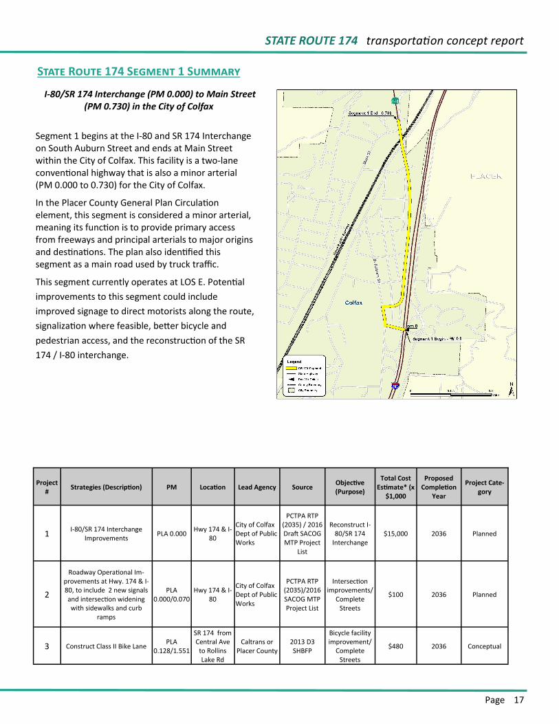
I-80/SR 174 Interchange (PM 0.000) to Main Street (PM 0.730) in the City of Colfax
Segment 1 begins at the I-80 and SR 174 Interchange on South Auburn Street and ends at Main Street within the City of Colfax. This facility is a two-lane conventional highway that is also a minor arterial (PM 0.000 to 0.730) for the City of Colfax.
In the Placer County General Plan Circulation element, this segment is considered a minor arterial, meaning its function is to provide primary access from freeways and principal arterials to major origins and destinations. The plan also identified this segment as a main road used by truck traffic.
This segment currently operates at LOS E. Potential
improvements to this segment could include
improved signage to direct motorists along the route,
signalization where feasible, better bicycle and
pedestrian access, and the reconstruction of the SR
174 / I-80 interchange.
State Route 174 Segment 1 Summary
Project #
Strategies (Description) PM Location Lead Agency Source Objective (Purpose)
Total Cost Estimate* (x
$1,000
Proposed Completion
Year
Project Cate-gory
1 I-80/SR 174 Interchange
Improvements PLA 0.000 Hwy 174 & I-
80
City of Colfax Dept of Public Works
PCTPA RTP (2035) / 2016 Draft SACOG MTP Project
List
Reconstruct I-80/SR 174
Interchange $15,000 2036 Planned
2
Roadway Operational Im-provements at Hwy. 174 & I-80, to include 2 new signals and intersection widening with sidewalks and curb
ramps
PLA 0.000/0.070
Hwy 174 & I-80
City of Colfax Dept of Public Works
PCTPA RTP (2035)/2016 SACOG MTP Project List
Intersection improvements/
Complete Streets
$100 2036 Planned
3 Construct Class II Bike Lane PLA
0.128/1.551
SR 174 from Central Ave
to Rollins Lake Rd
Caltrans or Placer County
2013 D3 SHBFP
Bicycle facility improvement/
Complete Streets
$480 2036 Conceptual
CALTRANS district 3
Page 18
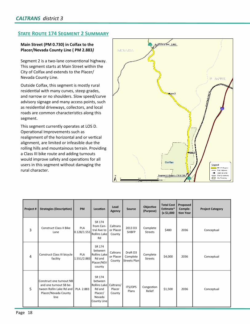
Segment 2 is a two-lane conventional highway. This segment starts at Main Street within the City of Colfax and extends to the Placer/Nevada County Line.
Outside Colfax, this segment is mostly rural residential with many curves, steep grades, and narrow or no shoulders. Slow speed/curve advisory signage and many access points, such as residential driveways, collectors, and local roads are common characteristics along this segment.
This segment currently operates at LOS D. Operational Improvements such as realignment of the horizontal and or vertical alignment, are limited or infeasible due the rolling hills and mountainous terrain. Providing a Class III bike route and adding turnouts would improve safety and operations for all users in this segment without damaging the rural character.
State Route 174 Segment 2 Summary
Main Street (PM 0.730) in Colfax to the Placer/Nevada County Line ( PM 2.883)
Project # Strategies (Description) PM Location Lead
Agency Source
Objective (Purpose)
Total Cost Estimate* (x $1,000
Proposed Comple-tion Year
Project Category
3 Construct Class II Bike
Lane PLA
0.128/1.551
SR 174 from Cen-tral Ave to
Rollins Lake Rd
Caltrans or Placer County
2013 D3 SHBFP
Complete Streets $480 2036 Conceptual
4 Construct Class III bicycle
facility PLA
1.551/2.883
SR 174 between
Rollins Lake Rd and
Placer/NEV county
Caltrans or Placer County
Draft D3 Complete
Streets Plan
Complete Streets $4,000 2036 Conceptual
5
Construct one turnout NB and one turnout SB be-
tween Rollin Lake Rd and Placer/Nevada County
line
PLA 2.883
SR 174 between
Rollins Lake Rd and Placer/Nevada
County Line
Caltrans/Placer County
ITS/OPS Plans
Congestion Relief
$1,500 2036 Conceptual
STATE ROUTE 174 transportation concept report
Page 19
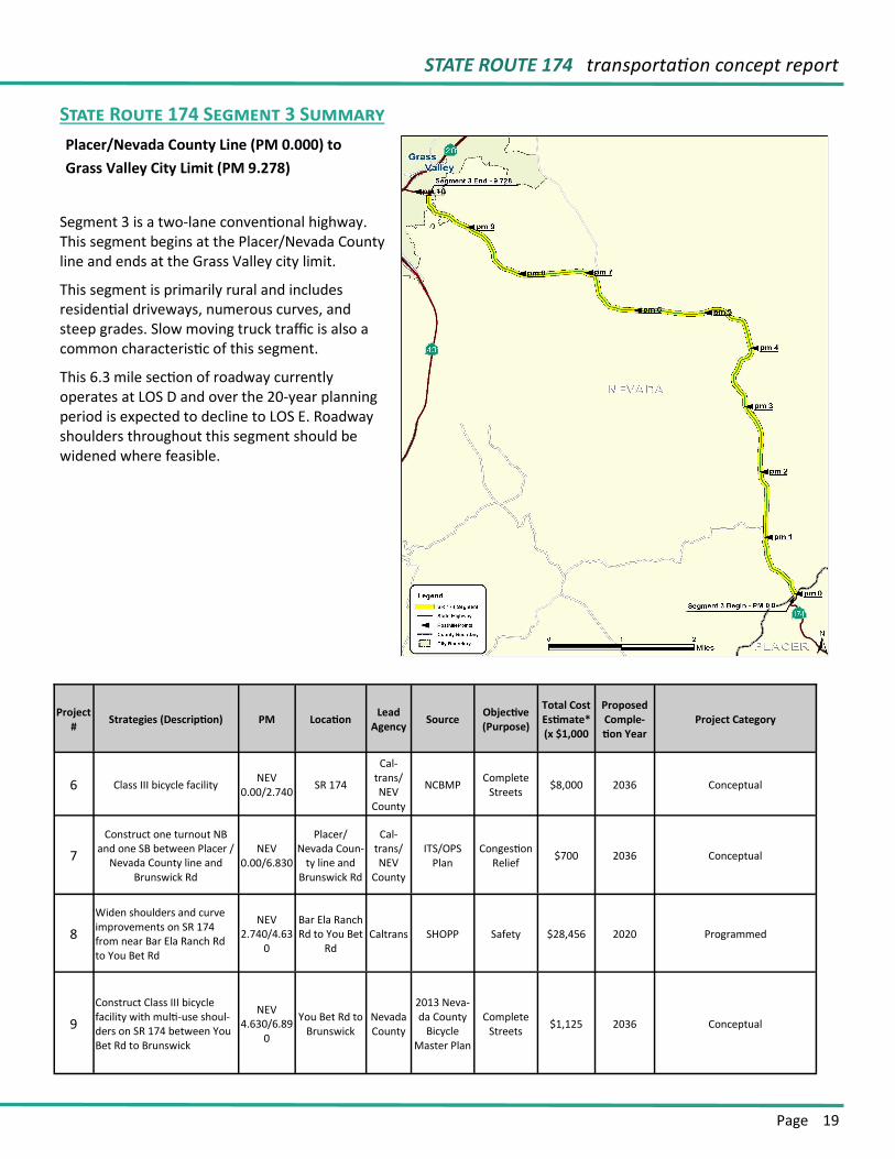
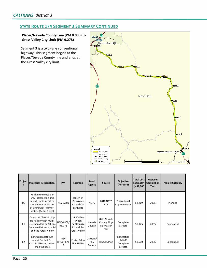
Segment 3 is a two-lane conventional highway. This segment begins at the Placer/Nevada County line and ends at the Grass Valley city limit.
This segment is primarily rural and includes residential driveways, numerous curves, and steep grades. Slow moving truck traffic is also a common characteristic of this segment.
This 6.3 mile section of roadway currently operates at LOS D and over the 20-year planning period is expected to decline to LOS E. Roadway shoulders throughout this segment should be widened where feasible.
State Route 174 Segment 3 Summary
Project #
Strategies (Description) PM Location Lead
Agency Source
Objective (Purpose)
Total Cost Estimate* (x $1,000
Proposed Comple-tion Year
Project Category
6 Class III bicycle facility NEV
0.00/2.740 SR 174
Cal-trans/NEV
County
NCBMP Complete
Streets $8,000 2036 Conceptual
7
Construct one turnout NB and one SB between Placer /
Nevada County line and Brunswick Rd
NEV 0.00/6.830
Placer/Nevada Coun-
ty line and Brunswick Rd
Cal-trans/NEV
County
ITS/OPS Plan
Congestion Relief
$700 2036 Conceptual
8
Widen shoulders and curve improvements on SR 174 from near Bar Ela Ranch Rd to You Bet Rd
NEV 2.740/4.63
0
Bar Ela Ranch Rd to You Bet
Rd Caltrans SHOPP Safety $28,456 2020 Programmed
9
Construct Class III bicycle facility with multi-use shoul-ders on SR 174 between You Bet Rd to Brunswick
NEV 4.630/6.89
0
You Bet Rd to Brunswick
Nevada County
2013 Neva-da County
Bicycle Master Plan
Complete Streets
$1,125 2036 Conceptual
Placer/Nevada County Line (PM 0.000) to
Grass Valley City Limit (PM 9.278)
CALTRANS district 3
Page 20
Placer/Nevada County Line (PM 0.000) to Grass Valley City Limit (PM 9.278)
State Route 174 Segment 3 Summary Continued
Project #
Strategies (Description) PM Location Lead
Agency Source
Objective (Purpose)
Total Cost Estimate* (x $1,000
Proposed Completion
Year Project Category
10
Realign to create a 4-way intersection and install traffic signal or roundabout on SR 174 at Brunswick Rd inter-section (Cedar Ridge)
NEV 6.809
SR 174 at Brunswick Rd and Ce-dar Ridge
NCTC 2010 NCTP
RTP Operational
Improvements $4,269 2035 Planned
11
Construct Class III bicy-cle facility with multi-
use shoulders on SR 174 between Rattlesnake Rd
and the Grass Valley
NEV 6.809/ R8.171
SR 174 be-tween
Rattlesnake Rd and the
Grass Valley
Nevada County
2013 Nevada County Bicy-cle Master
Plan
Complete Streets
$1,125 2035 Conceptual
12
Construct a left-turn lane at Bartlett Dr.,
Class III bike and pedes-trian facilities
NEV 8.490/8.71
0
Foster Rd to Pine Hill Dr.
Caltrans/NEV
County ITS/OPS Plan
Congestion Relief/
Complete Streets
$1,500 2036 Conceptual
Segment 3 is a two-lane conventional highway. This segment begins at the Placer/Nevada County line and ends at the Grass Valley city limit.
STATE ROUTE 174 transportation concept report
Page 21
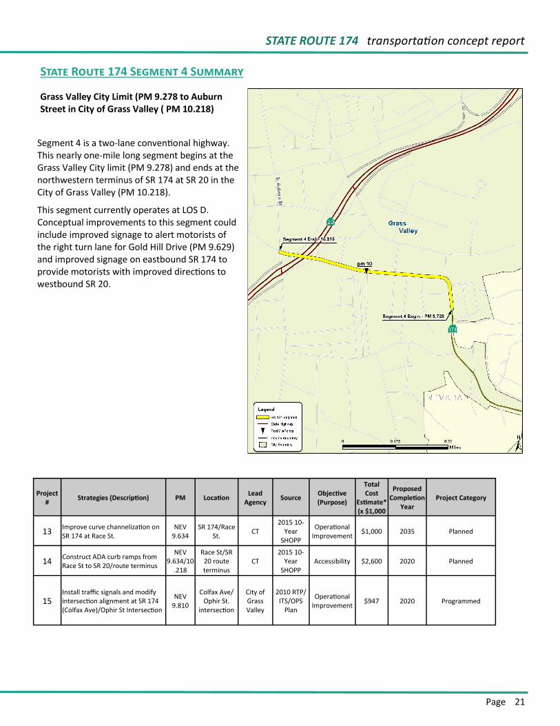
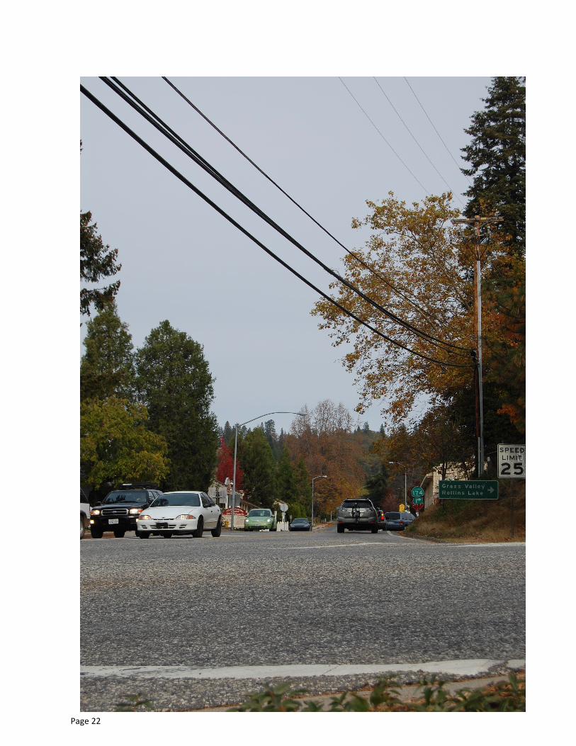
Segment 4 is a two-lane conventional highway. This nearly one-mile long segment begins at the Grass Valley City limit (PM 9.278) and ends at the northwestern terminus of SR 174 at SR 20 in the City of Grass Valley (PM 10.218).
This segment currently operates at LOS D. Conceptual improvements to this segment could include improved signage to alert motorists of the right turn lane for Gold Hill Drive (PM 9.629) and improved signage on eastbound SR 174 to provide motorists with improved directions to westbound SR 20.
State Route 174 Segment 4 Summary
Grass Valley City Limit (PM 9.278 to Auburn Street in City of Grass Valley ( PM 10.218)
Project #
Strategies (Description) PM Location Lead
Agency Source
Objective (Purpose)
Total Cost
Estimate* (x $1,000
Proposed Completion
Year Project Category
13 Improve curve channelization on SR 174 at Race St.
NEV 9.634
SR 174/Race St.
CT 2015 10-
Year SHOPP
Operational Improvement
$1,000 2035 Planned
14 Construct ADA curb ramps from Race St to SR 20/route terminus
NEV 9.634/10
.218
Race St/SR 20 route terminus
CT 2015 10-
Year SHOPP
Accessibility $2,600 2020 Planned
15 Install traffic signals and modify intersection alignment at SR 174 (Colfax Ave)/Ophir St Intersection
NEV 9.810
Colfax Ave/Ophir St.
intersection
City of Grass Valley
2010 RTP/ITS/OPS
Plan
Operational Improvement
$947 2020 Programmed
Page 22
Page 23
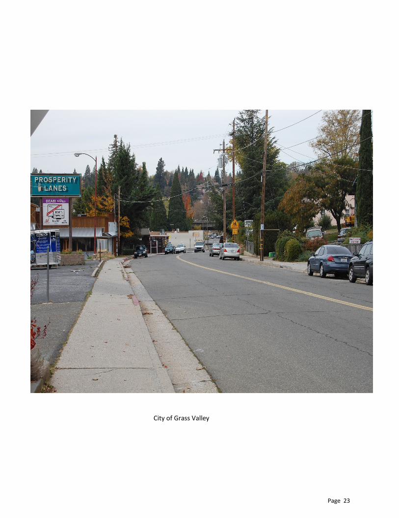
City of Grass Valley
Page 24
DISTRICT 3
California Department of Transportation
For questions and concerns about this Transportation Concept Report, please contact:
Caltrans District 3 Division of Planning and Local Assistance Office of System Planning Analysis, Modeling and Forecasting Branch 703 B Street, Marysville, CA 95901 Email: [email protected]
Phone: (530) 741-4199For further Transportation Concept Report information, please visit:
Caltrans District 3 Website:
http://www.dot.ca.gov/dist3/departments/planning
(Select System Planning, then Transportation Concept Reports)


