DISTRICT GROUNDWATER BROCHURE VILLUPURAM DISTRICT, TAMIL NADU T. BALAKRISHNAN SCIENTIST-D Government of India Ministry of Water Resources Central Ground Water Board South Eastern Coastal Region Chennai March 2009 For official use Technical Report Series
Transcript
DISTRICT GROUNDWATER BROCHURE
VILLUPURAM DISTRICT, TAMIL NADU
T. BALAKRISHNAN
SCIENTIST-D
Government of India
Ministry of Water Resources
Central Ground Water Board South Eastern Coastal Region
Chennai
March 2009
For official use
Technical Report Series
i
DISTRICT AT A GLANCE (VILLUPURAM DISTRICT)
S.
No.
ITEMS STATISTICS
1. GENERAL INFORMATION
i. Geographical area (Sq. km) 7222
ii. Administrative Divisions (As on 31-3-2007)
Number of Taluks
Number of Blocks
Number of Panchayats
Number of Villages
7
22
1104
1490
iii. Population (As on 2001 Census)
Total Population
Male
Female
29,60,373
14,92,442
14,67,931
iv. Average Normal Rainfall (1901-1980) (mm) 1119.8
GEOMORPHOLOGY
i. Major physiographic Units i) Structural hills, Residual
and denudational hills;
Shallow and buried
pediments; Older &
younger flood plains and
Beach landforms
2.
ii. Major Drainage Ponnaiyar, Malattar and
Gadilam
3. LAND USE (Sq. km) (2005-06)
i. Forest area
ii. Net area sown
iii. Cultivable area
717
3307
3894
4. MAJOR SOIL TYPES 1. Forest soil, 2. Red soil, 3.
Black soil and 4. Alluvial soil
5. AREA UNDER PRINCIPAL CROPS (Ha)
(2005-2006)
1. Paddy – 1,68,435
2. Groundnut – 59,842
3. Black gram – 18,158
4. Sugarcane – 17,202
5. Cumbu – 14,810
6. IRRIGATION BY DIFFERENT SOURCES
(2005-06) Number
Area irrigated
(Ha)
i. Dug wells 1,64,871 120661
ii. Tube wells 23454 54525
iii. Tanks 2085 61205
iv. Canals 196 6648
v. Other Sources --- 102
vi. Net irrigated area 243141 Ha
ii
S.
No.
ITEMS STATISTICS
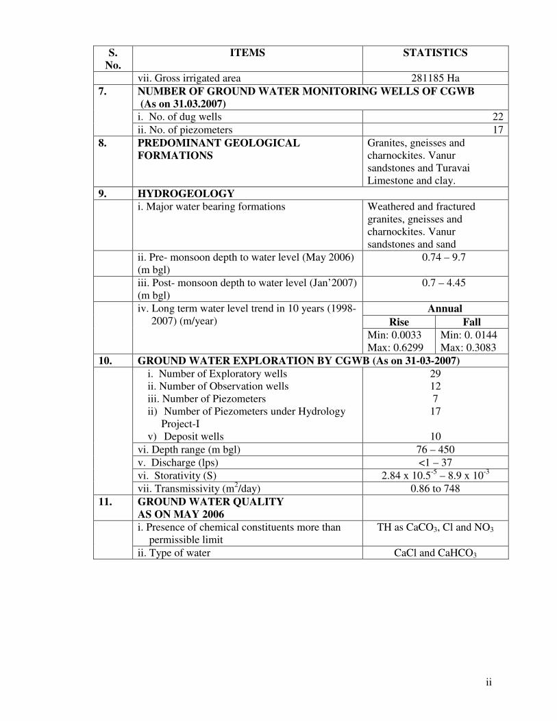
vii. Gross irrigated area 281185 Ha
NUMBER OF GROUND WATER MONITORING WELLS OF CGWB
(As on 31.03.2007)
i. No. of dug wells 22
7.
ii. No. of piezometers 17
8. PREDOMINANT GEOLOGICAL
FORMATIONS
Granites, gneisses and
charnockites. Vanur
sandstones and Turavai
Limestone and clay.
9. HYDROGEOLOGY
i. Major water bearing formations Weathered and fractured
granites, gneisses and
charnockites. Vanur
sandstones and sand
ii. Pre- monsoon depth to water level (May 2006)
(m bgl)
0.74 – 9.7
iii. Post- monsoon depth to water level (Jan’2007)
(m bgl)
0.7 – 4.45
Annual
Rise Fall
iv. Long term water level trend in 10 years (1998-
2007) (m/year)
Min: 0.0033
Max: 0.6299
Min: 0. 0144
Max: 0.3083
10. GROUND WATER EXPLORATION BY CGWB (As on 31-03-2007)
i. Number of Exploratory wells
ii. Number of Observation wells
iii. Number of Piezometers
ii) Number of Piezometers under Hydrology
Project-I
v) Deposit wells
29
12
7
17
10
vi. Depth range (m bgl) 76 – 450
v. Discharge (lps) <1 – 37
vi. Storativity (S) 2.84 x 10.5-5
– 8.9 x 10⁻³
vii. Transmissivity (m2/day) 0.86 to 748
11. GROUND WATER QUALITY
AS ON MAY 2006
i. Presence of chemical constituents more than
permissible limit
TH as CaCO3, Cl and NO3
ii. Type of water CaCl and CaHCO3
iii
12. DYNAMIC GROUND WATER RESOURCES
(as on 31.03.2004) (MCM)
i. Annual Replenishable Ground Water
Resources
1696
ii. Total Annul Ground Water Draft for all
purposes
1889
iii. Projected demand for Domestic and Industrial
Uses up to 25 years 2029
58
iv. Stage of Ground Water Development (%) 107
13. AWARENESS AND TRAINING ACTIVITY
i. Mass Awareness Programs Organized
Date 07.03.2002
Place Vanur
No. of Participants 300
ii. Water Management Training Organized
Date 07.03.2002
Place Villupuram
No. of Participants 25
14. EFFORTS OF ARTIFICIAL RECHARGE &
RAINWATER HARVESTING
Technical Guidance were
provided as when sought
i. Projects completed by CGWB
Number of structures
Amount spent
1. Constructed Subsurface
dyke (1 No.) at
Nallanpillaipetrol for Rs. 8
lacs. 2. Augmentation of
ground water through artificial
recharge in Vanur water shed
through Percolation Pond (7
Nos.) De-silting of Tanks (2
Nos.) for Rs. 71. 256 lacs
ii. Projects under technical guidance of CGWB
Number of structures Nil
15. GROUND WATER CONTROL AND REGULATION
i. Number of OE Blocks 14
ii. Number of Critical Blocks 3
iii. Number of Blocks Notified Nil
16. MAJOR GROUND WATER PROBLEMS
AND ISSUES
Ground water development in
this district is relatively high
in both hard and sedimentary
rock areas. Ground water
development has exceeded
100% in 14 blocks where as it
is between 90 and 100% in 3
blocks where the water levels
are deeper. It is inferred that a
major part of the district could
be vulnerable to water level
depletion.
1
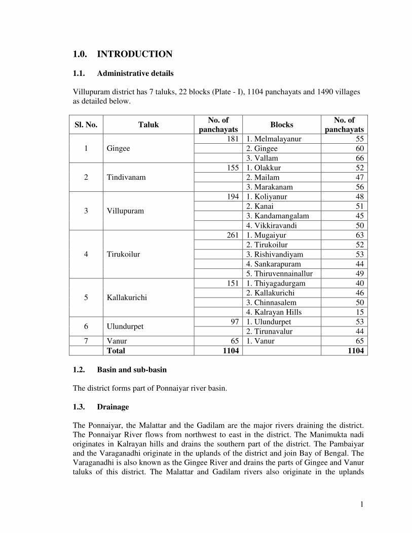
1.0. INTRODUCTION
1.1. Administrative details
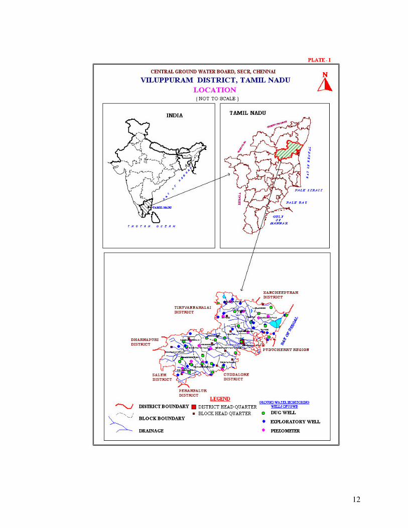
Villupuram district has 7 taluks, 22 blocks (Plate - I), 1104 panchayats and 1490 villages
as detailed below.
Sl. No. Taluk No. of
panchayats Blocks
No. of
panchayats
181 1. Melmalayanur 55
2. Gingee 60 1 Gingee
3. Vallam 66
155 1. Olakkur 52
2. Mailam 47 2 Tindivanam
3. Marakanam 56
194 1. Koliyanur 48
2. Kanai 51
3. Kandamangalam 45 3 Villupuram
4. Vikkiravandi 50
261 1. Mugaiyur 63
2. Tirukoilur 52
3. Rishivandiyam 53
4. Sankarapuram 44
4 Tirukoilur
5. Thiruvennainallur 49
151 1. Thiyagadurgam 40
2. Kallakurichi 46
3. Chinnasalem 50 5 Kallakurichi
4. Kalrayan Hills 15
97 1. Ulundurpet 53 6 Ulundurpet
2. Tirunavalur 44
7 Vanur 65 1. Vanur 65
Total 1104 1104
1.2. Basin and sub-basin
The district forms part of Ponnaiyar river basin.
1.3. Drainage
The Ponnaiyar, the Malattar and the Gadilam are the major rivers draining the district.
The Ponnaiyar River flows from northwest to east in the district. The Manimukta nadi
originates in Kalrayan hills and drains the southern part of the district. The Pambaiyar
and the Varaganadhi originate in the uplands of the district and join Bay of Bengal. The
Varaganadhi is also known as the Gingee River and drains the parts of Gingee and Vanur
taluks of this district. The Malattar and Gadilam rivers also originate in the uplands
2
within the district and flow eastwards to Cuddalore district. All the rivers are ephemeral
in nature and carry only floodwater during monsoon period. The drainage pattern is
mostly parallel to sub parallel and drainage density is very low. There are small
reservoirs across rivers namely Gomukha, Vedur and Mahanathur.
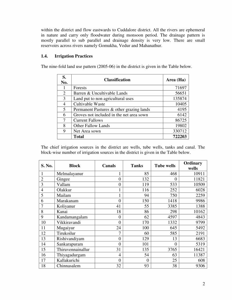
1.4. Irrigation Practices
The nine-fold land use pattern (2005-06) in the district is given in the Table below.
S.
No. Classification Area (Ha)
1 Forests 71697
2 Barren & Uncultivable Lands 56651
3 Land put to non agricultural uses 135874
4 Cultivable Waste 10405
5 Permanent Pastures & other grazing lands 4195
6 Groves not included in the net area sown 6142
7 Current Fallows 86725
8 Other Fallow Lands 19802
9 Net Area sown 330712
Total 722203
The chief irrigation sources in the district are wells, tube wells, tanks and canal. The
block-wise number of irrigation sources in the district is given in the Table below.
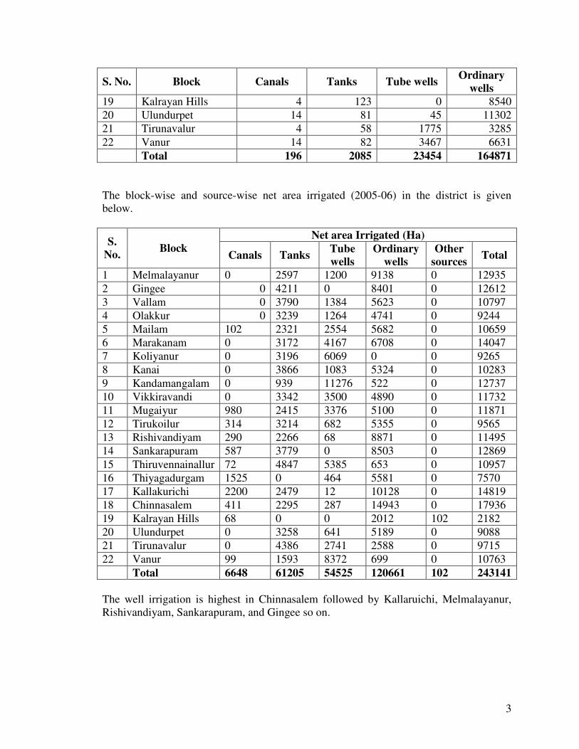
S. No. Block Canals Tanks Tube wells Ordinary
wells
1 Melmalayanur 1 85 468 10911
2 Gingee 0 132 0 11821
3 Vallam 0 119 533 10509
4 Olakkur 1 116 252 6028
5 Mailam 1 94 750 2259
6 Marakanam 0 150 1418 9986
7 Koliyanur 41 55 3385 1388
8 Kanai 18 86 298 10162
9 Kandamangalam 0 62 4597 4843
10 Vikkiravandi 0 170 1332 9799
11 Mugaiyur 24 100 645 5492
12 Tirukoilur 7 60 585 2191
13 Rishivandiyam 0 129 13 6683
14 Sankarapuram 0 101 0 5319
15 Thiruvennainallur 31 135 3765 16421
16 Thiyagadurgam 4 54 63 11387
17 Kallakurichi 0 0 25 608
18 Chinnasalem 32 93 38 9306
3
S. No. Block Canals Tanks Tube wells Ordinary
wells
19 Kalrayan Hills 4 123 0 8540
20 Ulundurpet 14 81 45 11302
21 Tirunavalur 4 58 1775 3285
22 Vanur 14 82 3467 6631
Total 196 2085 23454 164871
The block-wise and source-wise net area irrigated (2005-06) in the district is given
below.
Net area Irrigated (Ha) S.
No. Block
Canals Tanks Tube
wells
Ordinary
wells
Other
sources Total
1 Melmalayanur 0 2597 1200 9138 0 12935
2 Gingee 0 4211 0 8401 0 12612
3 Vallam 0 3790 1384 5623 0 10797
4 Olakkur 0 3239 1264 4741 0 9244
5 Mailam 102 2321 2554 5682 0 10659
6 Marakanam 0 3172 4167 6708 0 14047
7 Koliyanur 0 3196 6069 0 0 9265
8 Kanai 0 3866 1083 5324 0 10283
9 Kandamangalam 0 939 11276 522 0 12737
10 Vikkiravandi 0 3342 3500 4890 0 11732
11 Mugaiyur 980 2415 3376 5100 0 11871
12 Tirukoilur 314 3214 682 5355 0 9565
13 Rishivandiyam 290 2266 68 8871 0 11495
14 Sankarapuram 587 3779 0 8503 0 12869
15 Thiruvennainallur 72 4847 5385 653 0 10957
16 Thiyagadurgam 1525 0 464 5581 0 7570
17 Kallakurichi 2200 2479 12 10128 0 14819
18 Chinnasalem 411 2295 287 14943 0 17936
19 Kalrayan Hills 68 0 0 2012 102 2182
20 Ulundurpet 0 3258 641 5189 0 9088
21 Tirunavalur 0 4386 2741 2588 0 9715
22 Vanur 99 1593 8372 699 0 10763
Total 6648 61205 54525 120661 102 243141
The well irrigation is highest in Chinnasalem followed by Kallaruichi, Melmalayanur,
Rishivandiyam, Sankarapuram, and Gingee so on.
4
1.5. Studies/ Activities carried out by Central Ground Water Board (CGWB)
Central Ground Water Board completed systematic Survey by 1984 and reappraisal
survey were all again taken up during 1987, 2005 and 2006. Central Ground Water
Board has drilled deep exploratory wells (3 Nos.) down to depth of 450 m bgl during
1973 -77 in Auroville and Lake Estate areas. Deposit wells (10 Nos.) have been drilled in
sedimentary – hard rock contact areas for drinking water supply schemes during 1985-86.
Exploratory wells (29 Nos.) and observation wells (12 Nos.) have been drilled in hard
rock areas down to a depth of 300 m bgl during 1991-93. Purpose built piezometers (17
Nos.) were constructed under Hydrology Project-I in this district.
Ground Water Regime Monitoring is being carried out through dug wells ( 22 numbers)
and purpose built piezometers ( 17 numbers ). The measurements are being carried out 4
times in a year and Water Sampling is collected in the month of May.
2.0. RAINFALL AND CLIMATE
The district receives rainfall from southwest monsoon (June – September), northeast
monsoon (October – December) and non-monsoon periods (January – May). The rainfall
is generally heavy during low-pressure depressions and cyclones during the northeast
monsoon period. The normal annual rainfall is 1119.8 mm (1901-1980) and the higher is
towards coast.
The area falls under tropical climate with temperature in the summer months of March to
May. The average temperature varies from 26 to 410 C. The humidity is also high in the
order of 80%. The wind speed is high during the months of July and August. The wind
speed ranges from 7.4 to 12.6 km/hr, which increases from 100 to 120 km/hr during
cyclone period.
3.0. GEOMORPHOLOGY AND SOIL TYPES
3.1. Geomorphology
The residual hills and denudational hills are common in Tirukoilur, Kallakurichi and
Gingee taluks. Structural hills are noticed in the western part of the district. The shallow
pediments and buried pediments are common in the central part of the district. Coastal
areas are having older and younger flood plains and also beach landforms at places. The
ground slope is gentle towards coast. The valley fill near Villupuram is thick, which
forms main ground water discharge zone. Lineaments are restricted to parts of
Kallakurichi and Sankarapuram areas and productive fractures are noticed in select
pockets. The crystalline sedimentary contact fault is having sympathetic fractures in hard
rocks but mostly they are dry fractures.
5
Soils
The soils in the district are mostly forest soils and red soil. Alluvial soils are found in
eastern side bordering coast. Black soils are confined to low ground in select pockets in
Vanur taluk.
4.0. GROUND WATER SCENARIO
4.1. Hydrogeology
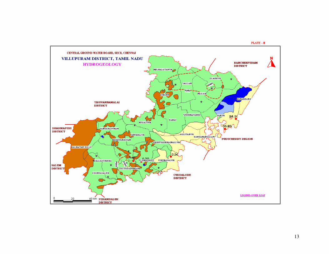
Villupuram district is underlain by crystalline metamorphic complex in the western part
of the district and sedimentary tract in eastern side (Plate-II). The thickness of sediments
exceeds 600m near southern part of the district. Groundwater occurs under phreatic and
semi–confined conditions in consolidated formations, which comprises weathered and
fractured granites, gneisses and charnockites whereas in unconsolidated sedimentary
rocks the groundwater occurs in phreatic, semi-confined conditions in Vanur sandstone,
Kadapperi kuppam formation and Turuvai limestone.
The district is having rocky outcrops in major part of Kallakurichi, Sankarapuram and
Tirukoilur taluks. The weathering is highly erratic and the depth of abstraction structures
is controlled by the intensity of weathering and fracturing. The depth of wells varies from
6.64 to 17 m bgl and water levels in observation wells tapping shallow aquifers varied
from 0.74 to 9.7 m bgl during pre monsoon (May 2006) and it varies from 0.7 to 4.45 m
bgl during post monsoon (January 2007).
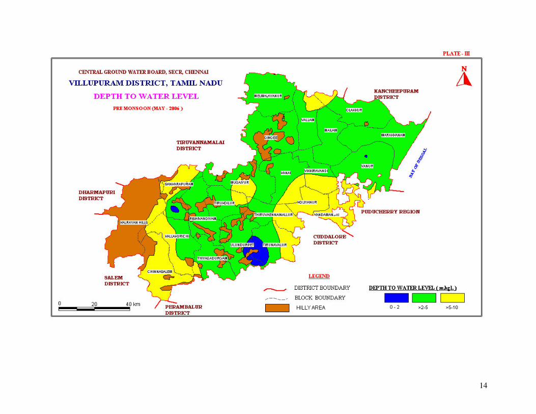
During pre monsoon, the depth to water levels in the range of >2 to 5 m bgl in major part
of the district, in the range of >5 -10 m bgl in western and southeastern parts of the
district and range of 0-2 m bgl were recorded in two isolated pockets (Plate –III).
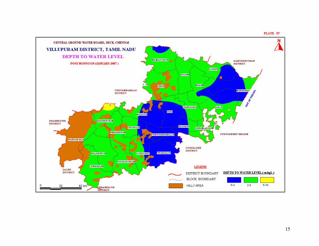
During post monsoon the depth to water levels range of >2 to 5 m bgl exists in major
part of the district, range of 0 - 2 m bgl prevails in central and northeastern parts of the
district and range of >5 - 10 m bgl were recorded in two isolated pockets in the
southwester and north western parts of the district (Plate –IV).
The depth to piezometric surface ranged from 2.8 to 11.25 m bgl during Pre monsoon and
0.5 to 6.35 m bgl during post monsoon.
The ground water is being developed my means of dug wells, bore wells and tube wells.
The diameter of the well is in the range of 7 to 10 m and depth of dug wells range from
15 to 18 m bgl depending on the weathered thickness and joints. The dug wells yield up
to 1 lps in summer months and few wells remains dry. The yield is adequate for irrigation
for one or two crops in monsoon period. The yield of bore wells in favorable locations
vary from <1 to 6 lps. The valley fills, intersection of lineaments, particularly, in the
western part along the foot hills of Kalrayan hills are reported to have potential pockets
suitable for dug wells and bore wells. The area of contact between crystalline and
sedimentary formations has variable yield prospects. The cretaceous formations are very
6
compact and yield prospects are low. The dug wells of 6 m diameter and 10 m bgl depth
in sandy tracts give about 3.5 lps. The yield of tube wells in the sedimentary formation
ranges from 2.4 to 37 lps.
4.1.1. Long-term fluctuation
The long –term water level fluctuation for the period of (1998-2007) indicates rise in
water level in the range of 0.003 to 0.63 m/year whereas the fall in the water level ranges
between 0.014 and 0.31 m /year.
4.1.2. Aquifer Parameters
The transmissivity values of fractured aquifers range from < 1 to 141 m2/day and
storativity varies between 2.84x10.5-5
and 8.9x10⁻³
. The transmissivity of sedimentary
formation varies form 21 to 748 m2/day and storativity is in the order of 2.75x10
-3.
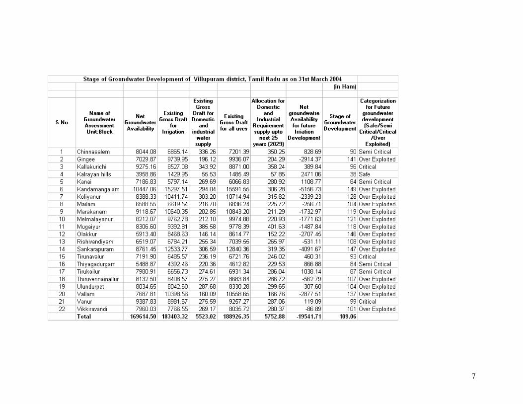
4.2. Ground water resources
The ground water resources have been computed jointly by Central Ground Water Board
and State Ground Water Resources Data Centre (PWD, WRO, Govt. of Tamil Nadu) as
on 31st March 2004. The computation has been done using GEC1997 methodology. The
salient features of the computations are furnished below.
4.3. Ground Water Quality
Ground water in phreatic aquifers in Villupuram district is, in general, colorless, odorless
and slightly alkaline in nature. The specific electrical conductance of ground water in
phreatic zone (µS/cm at 250 C) during May 2006 was in the range of 770 to 3650 in the
district. Conductance below 750 has been observed only in select pockets of the district.
It is observed that the ground water is suitable for drinking and domestic uses in respect
of all the constituents except total hardness and nitrate. In about 40% of samples, nitrate
concentration is above permissible limits of 100 mg/l. The incidence of high total
hardness is attributed to the composition of litho units constituting the aquifers in the
district, whereas nitrate pollution is most likely due to use of fertilizers and other
improper waste disposal.
Sodium Adoption Ration values range from 1.7 to 4.4 with an average value of 3.25 in
the district. This implies that no alkali hazard is anticipated to crops.
7
8
4.4. Status of Ground Water Development
Ground water development is very high in the district. There are number of dug wells and
dug cum bore wells in the hard rock areas while tube wells are common in the
sedimentary areas. The average draft of dug wells in hard rock areas is of the order of 1.2
ha.m./year. The extraction of ground water by shallow tube wells in the eastern part of
the district is of the order of 2.5 ha.m./year. The average command area for dug well and
bore well in the district is 2 ha and 3 ha respectively.
The hard rock areas in select pockets with valley fills and lineaments are having
appreciable ground water potential. At many pockets, the command areas are the main
potential ground water zones, The yield prospects are good in select pockets of
Villupuram, Sankarapuram and Kallakurichi areas where as it is very poor in Tirukoilur,
Ulundurpet, Gingee and Tindivanam taluks. The massive granites in Gingee and
Tindivanam taluks do not favour even bore wells. The augmentation of well yield by
horizontal and extension bores is successful in part of Kallakurichi and Tirukoilur areas.
The crystalline sedimentary contact zones have thick limestone capping followed by
productive granular zones, which are tapped, by number of cavity wells of 40 to 60 m bgl
depth giving 7 to 10 lps discharge. The tube wells can yield about 70 to 200 m3/hr and
can sustain pumping for 10 hrs a day.
5.0. GROUND WATER MANAGEMENT STRATEGY
5.1. Ground Water Development
The level of ground water development ranges from 38 to 149%. The over development
of ground water is recorded mostly in sedimentary tracts due to the feasibility of
successful tube wells. There are 14 blocks (Plate - V) with more than 100% development
of available replenishable source. There are 3 critical blocks.
The ground water development in different hydrogeological set up in the district needs
area specific well design. The major part of the hard rocks is suitable for large diameter
dug wells only. The horizontal bores and extension bores can be taken up only with the
detailed fracture pattern analysis coupled with resisitivity surveys. The horizontal bores
in down dip direction are commonly productive. A depth of 10 to 15 m dug well is
recommended for hard rock areas. The bore wells of 150 mm diameter and 90 m bgl
depth is recommended for water supply scheme with hand pumps. Specific areas having
shear zones and intersection of lineament can be considered for 90 to 120 m bgl depth
bore well for power pump schemes and to a limited extent for developing horticulture.
Tube wells in this area can give 3 lps. The deep tube well of 100 - 400 mbgl in the
eastern side within U. T. of Puducherry enclaves can yield as high as 17 lps discharge
which can be pumped with 10 HP submersible pumps. The coastal tract is Marakanam
9
belt has fresh water in shallow zones down to 40 m bgl. The deeper zones at coastal tract
have saline water.
Some of the deep bore wells constructed by Central Ground Water Board in hard rocks
are used for water supply schemes and also 10 deposit wells drilled in sedimentary areas
by CGWB at the request of TWAD Board are used for comprehensive water supply
schemes.
Many pockets in Kallakurichi, Ulundurpet, Gingee and Tirukoilur taluks have very low
yield. The pumping test date of select dug wells indicated that the specific yield is in the
range of 1 to 2 %. The rational approach in deciding the spacing of wells in hard rock
areas is required and it may be in use in planning to have fixed number of wells in every
hydrogeological unit depending on the recharge-discharge characteristics. In the absence
of detailed picture taking the overall ground water development of the basin spacing of
100 m for dug wells without pump set and 150 m for pump set wells can be kept.
The situation in compact sedimentary tract is also complex for proper management. The
tube wells have direct interference due to near by radial flow, the coastal morphology and
seawater - fresh water interface has to be considered for proper ground water
development.
5.2. Water Conservation and Artificial Recharge
CGWB had prepared a master plan to augment groundwater potential by saturating the
shallow aquifer taking into consideration the available unsaturated space during post
monsoon and available uncommitted surplus run off. Subsequently, computations have
been made for Drought Prone Area Program (DPAP) for over exploited and critical
blocks in the districts warranting immediate attention. Institute of Remote Sensing, Anna
University had prepared block wise maps demarcating potential zones for artificial
recharge for the State of Tamil Nadu. Subsequently, State Government agencies have
constructed artificial recharge structures with their own fund or with fund from Central
Government, dovetailing various government programs.
Ministry of Water Resources, Government of India has initiated Dug Well Recharge
Scheme in the State. The scheme is being implemented by the Nodal Department
(SG&SWRDC, PWD, WRO, Government of Tamil Nadu) with the technical guidance of
CGWB. The subsidy of Rs. 4000/- for small and marginal farmers and Rs. 2000/- for the
other farmers is credited to the beneficiaries’ bank account through NABARD. The
scheme after implementation will prove to be beneficial to the irrigation sector. The
available uncommitted surplus run off has to be recomputed, taking into consideration the
quantum of recharge effected through existing irrigation dug wells also. The existing
structures and uncommitted surplus flow should be considered for further planning of
artificial recharge program.
On the basis of experimental studies, it has been found that de-silting of existing tanks
followed by percolation pond with recharge wells, recharge shafts are economical.
10
There is considerable scope for implementation of roof – top rainwater harvesting in the
district. Recharge pits / Shafts / trenches of suitable design are ideal structures for
rainwater harvesting in such areas. Central Ground Water Board is also providing free
technical guidance for implementation of rooftop rainwater harvesting schemes.
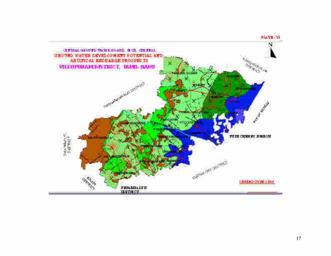
A map showing the development prospects and Artificial recharge structures
recommended for various blocks in Villupuram district are shown in Plate-VI.
6.0. AWARENESS AND TRAINING ACTIVITY
6.1. Mass awareness program and Water Management Training program by
Central Ground Water Board
CGWB, SECR, Chennai conducted mass awareness program and water management
training program during the AAP 2001-02 at Vanur, Villupuram district and Water
Management Training was conducted at Villupuram.
7.0. AREA NOTIFIED
Central Ground Water Authority has not notified any area in the district. Government of
Tamil Nadu vide G.O.No. 53 has restricted groundwater development for irrigation in the
over exploited blocks of Tamil Nadu. The over exploited blocks in this district are as
follows.
1. Gingee 2. Melmalayanur 3. Tiruvennailnallur
4. Kandamangalam 5. Mugaiyur 6. Ulundurpet
7. Koliyanur 8. Olakkur 9. Vallam
10. Mailam 11. Rishivandiyam 12. Vikkiravandi
13. Marakanam 14. Shankarapuram
8.0 RECOMMENDATIONS
Agricultural development in the district has to be planned in accordance with the
hydrogeological and hydrochemical regime and area specific strategy is needed for better
water management. The realistic ground water potential available and irrigation potential
created has to be studied in totality for individual watershed.
The small irrigation potential created from minor irrigation projects can be studied in
detail and possibility of turn system like Aliyar Project in Coimbatore district can be
planned to bring more area under irrigation.
11
The construction of tube wells in Vanur and Villupuram taluks has to be regulated by at
least a regional ground water control bill similar to one is Madras Metropolitan area. The
problem should be analyzed for the entire tract in totality and a combined effect to
monitor the seawater interface movement is needed. If need be, planning and
implementation of remedial measures like fresh water barrier ridge by series of injection
well along the coast is recommended.
The monsoon rainfall is erratic and stormy days heavy precipitation. The flash floods
from the rivers reach the sea without proper utilization. It is recommended to de-silt the
supply channels to irrigation tanks and improve the river tank connection system. The
contact zone between sedimentary and crystalline rocks is ideal for recharge structures.
The combination of basin spread and injection well to recharge the high exploited
sedimentary zone is the need of the hour.
The quality of water in Kaluveli tank and saltpan areas as well as aquaculture activity in
coastal areas has to be closely monitored. As and when needed the specific activity
effecting general water environment has to be controlled to avoid any deterioration in the