17/08/2018 DISTRICT SURVEY REPORT OF GAYA Stone Mineral As per Notification no. S.O.3611 (E) New Delhi, the 25 th July, 2018 of Ministry of Environment Forest and Climate change, Government of India Prepared by INSTITUTE OF ENVIRONMENT & ECO - DEVELOPMENT, PATNA Ground Floor, Shyam Nagar Colony, Maurya Path, Khajpura P.O. B.V. College, Patna-800014, Bihar, India E-mail- [email protected]Website- www.ieedindia.in Tel.: 0612-2590373, Telefax- 0612-2590373 M-+91- 9472919161, 7004620817 Submitted to Under Secretary Mines & Geology Department, Government of Bihar
Transcript
17/08/2018
DISTRICT SURVEY REPORT OF GAYA Stone Mineral
As per Notification no. S.O.3611 (E) New Delhi, the 25th July, 2018 of Ministry of Environment Forest and Climate change, Government of India
Prepared by
INSTITUTE OF ENVIRONMENT & ECO- DEVELOPMENT, PATNA
Under Secretary Mines & Geology Department, Government of Bihar
DISTRICT SURVEY REPORT I STONE MINING I GAYA I BIHAR Page 2
PREFACE
The Ministry of Environment, Forests & Climate Change (MoEF&CC), Government of India,
made Environmental Clearance (EC) for mining of minerals mandatory through its Notification
of 27th January, 1994 under the provisions of Environment Protection Act, 1986. Keeping in
view the experience gained in environmental clearance process over a period of one decade, the
MoEF&CC came out with Environmental Impact Notification, SO 1533 (E), dated 14th
September 2006. Now again Ministry of Environment, Forests & Climate Change (MoEF&CC),
Government of India amended the notification S.O. 141(E) Dated 15th January, 2016 vide S.O.
3611(E) Dated 25th July, 2018. It has been made mandatory to obtain environmental clearance
for different kinds of development projects as listed in Appendix-X of the Notification.
Further, in pursuance to the order of Hon’ble Supreme Court dated the 27th February, 2012 in
I.A. No.12- 13 of 2011 in Special Leave Petition (C) No.19628-19629 of 2009, in the matter of
Deepak Kumar etc. Vs. State of Haryana and Others etc., prior environmental clearance has now
become mandatory for mining of minor minerals irrespective of the area of mining lease; And
also in view of the Hon’ble National Green Tribunal, order dated the 13th January, 2015 in the
matter regarding sand mining has directed for making a policy on environmental clearance for
mining leases in cluster for minor Minerals, The Ministry of Environment, Forest and Climate
Change in consultation with State governments has prepared Guidelines on Sustainable Sand
Mining detailing the provisions on environmental clearance for cluster, creation of District
Environment Impact Assessment Authority and proper monitoring of minor mineral mining
using information technology and information technology enabled services to track the mined
out material from source to destination.
The DEIAA and DEAC will scrutinize and recommend the prior environmental clearance of
mining of minor minerals on the basis of District Survey Report. This will a model and guiding
document which is a compendium of available mineral resources, geographical set up,
environmental and ecological set up of the district and replenishment of minerals and is based on
data of various departments, published reports, journals and websites. The District Survey Report
will form the basis for application for environmental clearance, preparation of reports and
appraisal of projects. The Report will be updated once every five years.
DISTRICT SURVEY REPORT I STONE MINING I GAYA I BIHAR Page 3
OBJECTIVES
The main objective of the preparation of District Survey Report is to ensure the following –
Identification of mineral wealth in the district.
Identification of areas of Minor Mineral having the potential mineral where mining
can be allowed. And
Identification of areas of proximity to infrastructural structures and installations
where mining should be prohibited.
DISTRICT SURVEY REPORT I STONE MINING I GAYA I BIHAR Page 4
INDEX
Sl. No. Chapters Page No.
1 Introduction 5
2 Overview of Mining Activity in the District 9
3 General Profile of the District 11
4 Geology of the District 17
5 Drainage of Irrigation pattern 19
6 Land Utilization Pattern in the District : Forest, Agricultural, Horticulture,
Mining etc.;
22
7 Surface Water and Ground Water scenario of the district; 25
8 Rainfall of the district and climatic condition 30
9 Details of the mining leases in the District 32
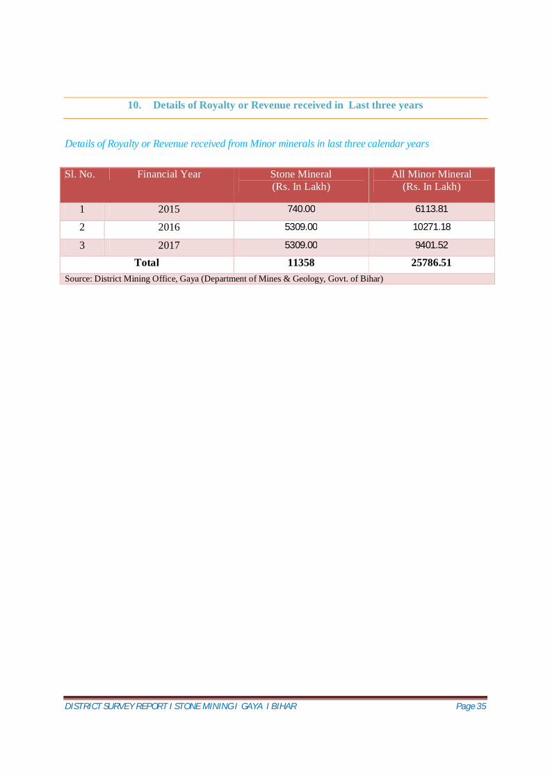
10 Details of Royalty or Revenue received in last three years 35
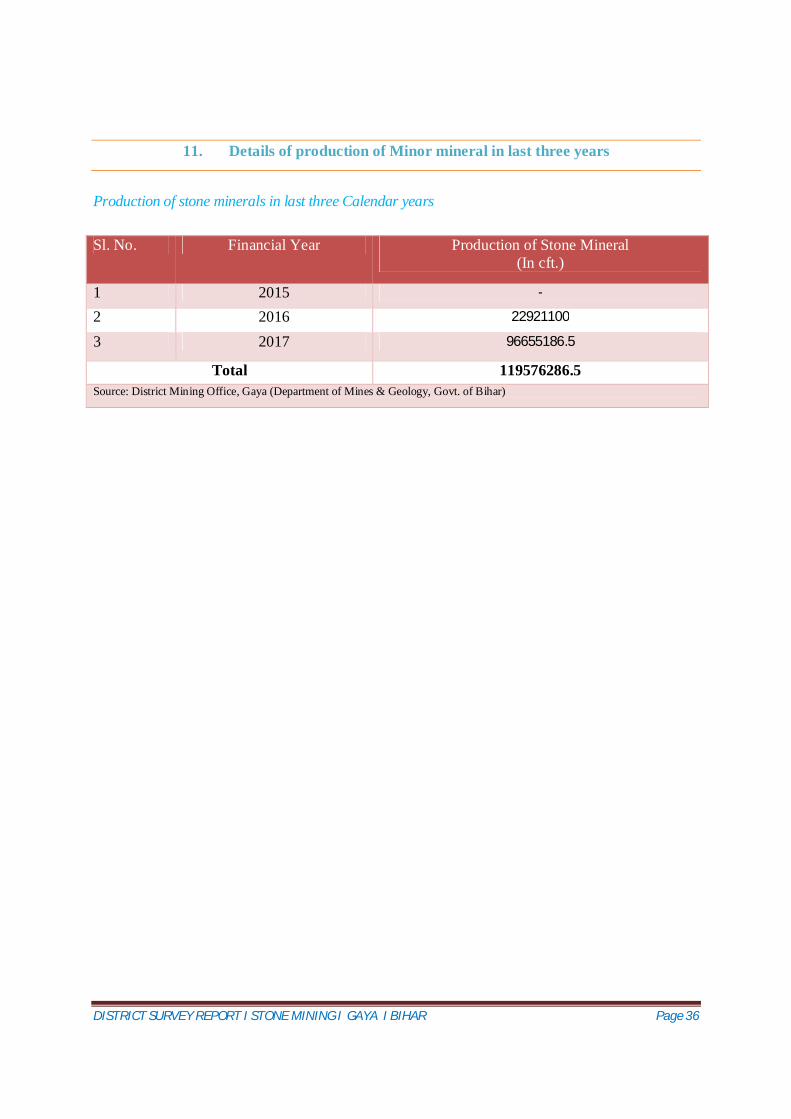
11 Details of Production of Minor Minerals in last three years 36
12 Mineral Map of the District 37
13 List of letter of Intent (LOI) Holders in the District along with its validity 39
14 Total Mineral Reserve available in the District 41
15 Quality/ Grade of Mineral available in the district 42
16 Use of Mineral 43
17 Demand and supply of the Mineral in last three years 45
18 Mining Lease marked on the map of the district 46
19 Details of cluster of mining lease viz. number of mining lease location (Latitude
and longitude)
50
20 Eco Sensitive area in the district 51
21 Impact on the Environment (Air, Water, Noise, Soil, Flora & Fauna, Land use,
Agriculture, forest etc.) due to mining activity
52
22 Remedial measure to mitigate the impact of mining on the environment 55
23 Reclamation on mined out area in the district 57
24 Risk assessment and disaster management plan 58
25 Details of occupational health ( Last five year Data of number of patient of
Silicosis & Tuberculosis)
62
26 Plantation and Green Belt Development in respect of lease already granted 63
27 References 67
DISTRICT SURVEY REPORT I STONE MINING I GAYA I BIHAR Page 5
1. Introduction
Historical Perspective
Gaya has experienced the rise and fall of many dynasties in the Magadh Region. From the 6 th century BC to the 18 th century AD, about 2300-2400 years, Gaya has been occupying an important place in the cultural history of the region. It opened up with the Sisunaga dynasty founded by Sisunaga, who exercised power over Patna and Gaya around 600 BC. Bimbisara, fifth in line, who lived and ruled around 519 BC, had projected Gaya to the outer world. Having attained an important place in the history of civilisation, the area experienced the bliss of Gautam Buddha and Bhagwan Mahavir during the reign of Bimbisara. After a short spell of Nanda dynasty, Gaya and the entire Magadh region came under the Mayuryan rule with Ashoka (272 BC – 232 BC) embracing Buddhism. He visited Gaya and built the first temple at Bodh Gaya to commemorate Prince Gautama's attainment of supreme enlightenment.
The period of Hindu revivalism commenced with the coming of the Guptas during the 4 th and 5 th century A.D. Samudragupta of Magadh helped to bring Gaya in limelight. It was the headquarter of Behar district during the Gupta empire.
Gaya then passed on to the Pala dynasty with Gopala as the ruler. It is believed that the present temple of Bodh Gaya was built during the reign of Dharmapala, son of Gopala.
Gaya came under the reign of Muhamaddan rulers in the 12 th century with Muhammad Bakhtiyar Khilji invading the region. For a short period thereafter, the Pathan Chief Sher Shah ruled over the place at the end of 16 th century. The place finally passed on to the Britishers after the battle of Buxar in 1764. Gaya, alongwith other parts of the country, won freedom in 1947.
Gaya finds mention in the great epics, Ramayana and Mahabharata. Rama alongwith Sita and Lakshmana visited Gaya for offering PINDAN to their father Dasharath. In Mahabharat, the place has been identified as Gayapuri.
Gaya formed a part of the district of Behar and Ramgarh till 1864. It was given the status of independent district in 1865. Subsequently, in May 1981, Magadh Division was created by the Bihar State Government with the districts of Gaya, Nawada, Aurangabad and Jehanabad. All these districts were at the level of sub-division when the Gaya district was created in 1865. About the origin of the name ‘Gaya' as referred to in Vayu Purana is that Gaya was the name of a demon (Asura) whose body was pious after he performed rigid penance and secured blessings from Vishnu. It was said that the Gayasura's body would continue to be known as Gaya Kshetra.
DISTRICT SURVEY REPORT I STONE MINING I GAYA I BIHAR Page 6
It would be incumbent upon all sons to offer PINDA (oblations) for the salvation of the soul of their ancestors. All the 360 vedis for pindadana were located within this Pancha Kosi Gaya Kshetra. The soul could be freed from the agonies of Hell and sent to Heaven by performing Gaya-Shraddha within this area. Gaya has been named after the demon.
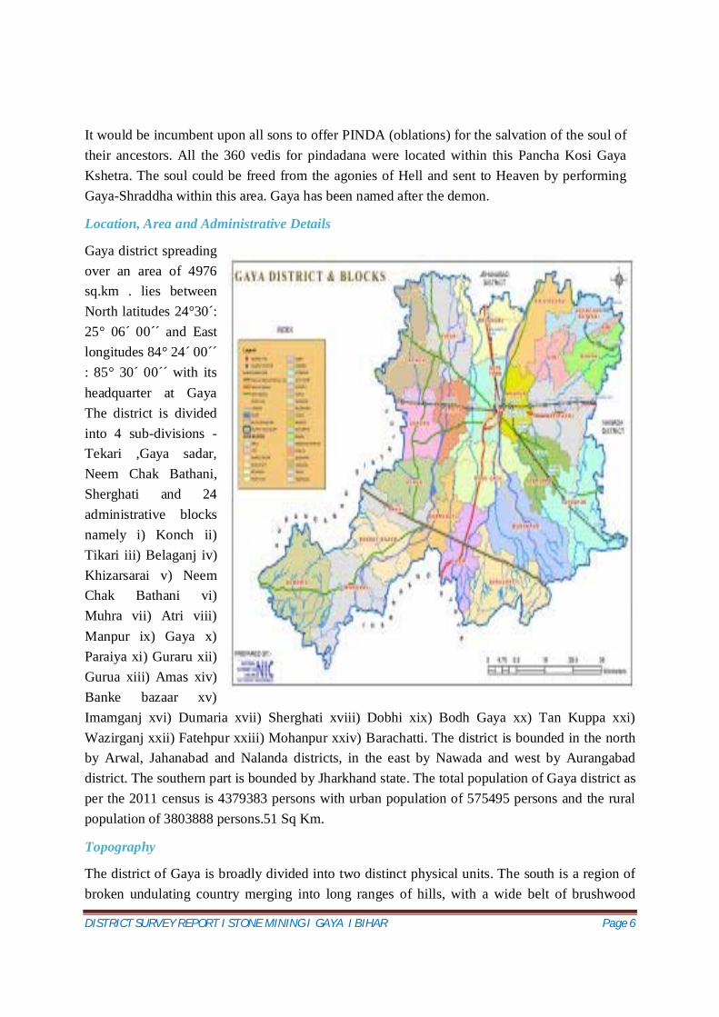
Location, Area and Administrative Details
Gaya district spreading over an area of 4976 sq.km . lies between North latitudes 24°30´: 25° 06´ 00´´ and East longitudes 84° 24 ́00´´ : 85° 30´ 00´´ with its headquarter at Gaya The district is divided into 4 sub-divisions - Tekari ,Gaya sadar, Neem Chak Bathani, Sherghati and 24 administrative blocks namely i) Konch ii) Tikari iii) Belaganj iv) Khizarsarai v) Neem Chak Bathani vi) Muhra vii) Atri viii) Manpur ix) Gaya x) Paraiya xi) Guraru xii) Gurua xiii) Amas xiv) Banke bazaar xv) Imamganj xvi) Dumaria xvii) Sherghati xviii) Dobhi xix) Bodh Gaya xx) Tan Kuppa xxi) Wazirganj xxii) Fatehpur xxiii) Mohanpur xxiv) Barachatti. The district is bounded in the north by Arwal, Jahanabad and Nalanda districts, in the east by Nawada and west by Aurangabad district. The southern part is bounded by Jharkhand state. The total population of Gaya district as per the 2011 census is 4379383 persons with urban population of 575495 persons and the rural population of 3803888 persons.51 Sq Km.
Topography
The district of Gaya is broadly divided into two distinct physical units. The south is a region of broken undulating country merging into long ranges of hills, with a wide belt of brushwood
DISTRICT SURVEY REPORT I STONE MINING I GAYA I BIHAR Page 7
jungle at their base. Much of this tract is high and barren and incapable of much cultivation; the soil has poor crops and the population is sparse. These high lands project into the alluvial plains to the north as spurs from the C Chhotanagpur Plateau. The greater part of the district, however, consists of the flat alluvial plain. This wide alluvial plain of the north forms part of the Gangetic depression with alluvial deposits of immense depth and is broken here and there by groups and low ranges of hills or isolated peaks arising abruptly from the level country at their feet. The alluvial plain is protected from drought by a wonderful system of indigenous irrigation consisting of ahars (reservoirs) and pains (channels). It is, therefore, a region of great fertility when compared with the southern part of the district and is comparatively densely populated.
The northern portion, which is highly cultivated and extensively irrigated.
Connectivity
Gaya is well connected to the rest of India and the world by roadways, railways and airways.
Roadways The Grand Trunk Road (NH-2, which is undergoing a revival under The Golden Quadrilateral project) is about 30 km. from Gaya city. Thus, Gaya is well connected to Kolkata, Varanasi, Allahabad, Kanpur, Delhi, Amritsar, and to the Pakistani cities of Lahore and Peshawar. The highway connecting Gaya to Patna is now in a good condition, also the railway services between the two stations is up to the mark.
Railways Gaya is the second most important station in Bihar after Patna. It is a junction and is connected to the three of the four metropolises New Delhi, Kolkata and Mumbai through Important Broad Gauge Routes (direct trains), including the Grand Chord line. There is a direct non-stop train, the Mahabodhi Express from New Delhi to Gaya daily. It takes around 16 hours to reach Gaya from New Delhi through train.
There are direct trains from Gaya to other important stations in India like Ranchi, Varanasi, Lucknow, Kanpur, Allahabad, Agra, Mathura, Jabalpur, Bhopal, Indore, Nagpur, Puri, etc. There are also two smaller train lines from Gaya, one to Patna and the other to Kiul.
Airways Gaya has the only international airport in Bihar and Jharkhand taken together. It is an
DISTRICT SURVEY REPORT I STONE MINING I GAYA I BIHAR Page 8
international airport connected to Colombo, Sri Lanka through two airline operators; Bangkok, Thailand; Singapore, and Paro, Bhutan. It is said to be being developed as a stand-by to the Calcutta airport. Gaya Airport is served by Indian Airlines for domestic flights and Sri Lankan Airlines, Mihin Lanka, Druk Air and Indian Airlines for international flights. Thai Airways is planning a non-stop flight to Gaya from Bangkok. The distance of gaya airport to National Heritage sites "Bodh-Gaya" about 5 Kilometers.
Source: Census of India 2011
DISTRICT SURVEY REPORT I STONE MINING I GAYA I BIHAR Page 9
2. Overview of Mining Activity in the District
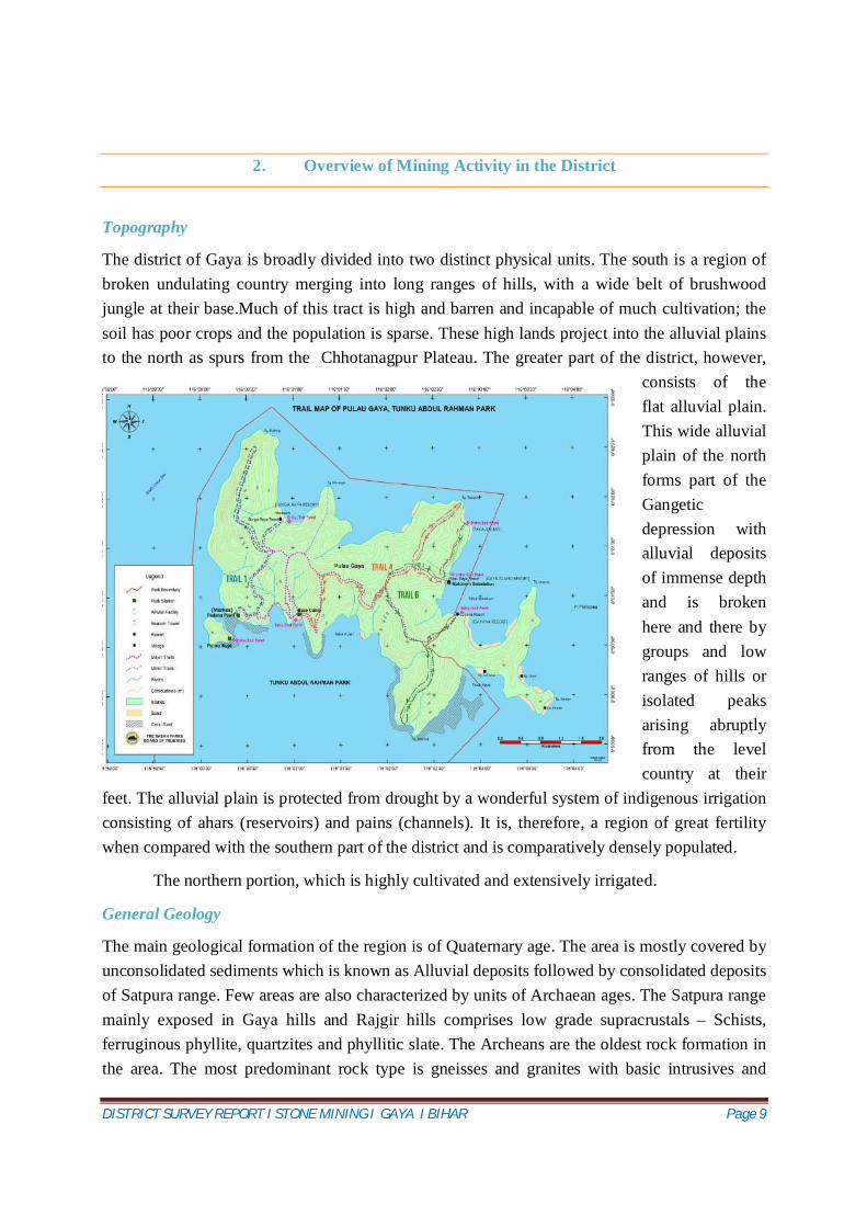
Topography
The district of Gaya is broadly divided into two distinct physical units. The south is a region of broken undulating country merging into long ranges of hills, with a wide belt of brushwood jungle at their base.Much of this tract is high and barren and incapable of much cultivation; the soil has poor crops and the population is sparse. These high lands project into the alluvial plains to the north as spurs from the Chhotanagpur Plateau. The greater part of the district, however,
consists of the flat alluvial plain. This wide alluvial plain of the north forms part of the Gangetic depression with alluvial deposits of immense depth and is broken here and there by groups and low ranges of hills or isolated peaks arising abruptly from the level country at their
feet. The alluvial plain is protected from drought by a wonderful system of indigenous irrigation consisting of ahars (reservoirs) and pains (channels). It is, therefore, a region of great fertility when compared with the southern part of the district and is comparatively densely populated.
The northern portion, which is highly cultivated and extensively irrigated.
General Geology
The main geological formation of the region is of Quaternary age. The area is mostly covered by unconsolidated sediments which is known as Alluvial deposits followed by consolidated deposits of Satpura range. Few areas are also characterized by units of Archaean ages. The Satpura range mainly exposed in Gaya hills and Rajgir hills comprises low grade supracrustals – Schists, ferruginous phyllite, quartzites and phyllitic slate. The Archeans are the oldest rock formation in the area. The most predominant rock type is gneisses and granites with basic intrusives and
DISTRICT SURVEY REPORT I STONE MINING I GAYA I BIHAR Page 10
pegmatoides.The area is dominated by medium to fine sand geologically the area comprising of Terrace alluvium deposited in depositional terraces of old rivers & contain cyclic sequence of fine to course grained sand. It is angular to sub angular and the angularity of the grains of this category of sand decreases with depth.
Availability of Mineral resources
The mineral resources of Gaya district playing massive role in industrial, social and economic development of the district.
Available mineral resources in the district
Mica
Sand
Sandstones
Quartzite
DISTRICT SURVEY REPORT I STONE MINING I GAYA I BIHAR Page 11
3. General Profile of the District
General Profile
Sl. No. Items Statistics
01 General information I) Geographical area (Sq.km) 4976 Ii) Administrative Divisions 4 Number of Tehsil/Block 24 Number of Panchyat 332
Villages 2860 Iii) Population (As on 2011 Census): 4379383 Iv) Average Annual Rainfall (mm) 1086
DISTRICT SURVEY REPORT I STONE MINING I GAYA I BIHAR Page 12
02 Geomorphology Major physiographic units Unconsolidated sand and
weathered and fractured Major Drainages Falgu, Morhar, Dardha, Paimar
03 Land use (ha) A) Forest area: 778.36 sq.km. B) Net area sown: 1705.22 sq. Km C) Total Cropped area: 2037.13sq.km
04 Major soil types Alfisol, Entisols. 05 Area under principal rops
Irrigation by different sources (Area in ha, Govt. Of Bihar 2008-09)
Area (ha)
Dug wells and Tube wells 12000 ha Canal 5,000 ha Net irrigated area 1,26,000 ha Gross irrigated area 1,64,000 ha
Hydrogeology Major Water bearing formations Pre-monsoon Depth to water level during 2011
1.Weathered & Fractured Granite 2. Alluvium 6-15 m bgl
Post-monsoon Depth to water level during 2011 Long term water level trend in 10 years (2002-2011) in m/yr
1.55-5.78 m bgl No significant decline
07 Ground water exploration by cgwb (as on 31.03.2013) No. Of wells drilled (EW, OW, PZ, SH = Total)
EW=11, OW=9
Depth Range (m) 31.18– 150.48 m bgl Discharge 2.6-35.67 Storativity (S) 1.2x10⁻³ to 1.4x10⁻⁵ Transmissivity (m2/day) 126– 168
08 Ground Water Quality Presence of Chemical constituents more than permissible limit (e.g., EC, F, As, Fe)
F
09 Dynamic Ground Water Resources (as on 31st March 2009) – in mcm Annual Replenishable Ground Water Resources 1046.34 Net Annual Ground Water Draft 506.64 Projected Demand for Domestic and Industrial Uses up to 2025
123.9
Stage of Ground Water Development 48.4% Source: Centre for Ground Water Board (CGWB)
DISTRICT SURVEY REPORT I STONE MINING I GAYA I BIHAR Page 13
Topography
The district of Gaya is broadly divided into two distinct physical units. The south is a region of broken undulating country merging into long ranges of hills, with a wide belt of brushwood jungle at their base.Much of this tract is high and barren and incapable of much cultivation; the soil has poor crops and the population is sparse. These high lands project into the alluvial plains to the north as spurs from the Chhotanagpur Plateau. The greater part of the district, however, consists of the flat alluvial plain. This wide alluvial plain of the north forms part of the Gangetic depression with alluvial deposits of immense depth and is broken here and there by groups and low ranges of hills or isolated peaks arising abruptly from the level country at their feet. The alluvial plain is protected from drought by a wonderful system of indigenous irrigation consisting of ahars (reservoirs) and pains (channels). It is, therefore, a region of great fertility when compared with the southern part of the district and is comparatively densely populated.
The northern portion, which is highly cultivated and extensively irrigated.
Physiography
The Bihar state can be broadly subdivided into three major unit’s i.e., main physical sub-divisions is the Norhern Mountains, the Gangetic Plains and the Central Highlands. Northern Mountains comprises the Himalayan ranges including their foot hills. The Gangetic plains, situated between the Himalayas and the Deccan plateau,constitute the most fertile plains of the sub-basin ideally suited for intensive cultivation.The Central highlands lying to the south of the Great plains consists of mountains, hills and plateaus intersected by valleys and river plains.They are largely covered by forests.Aravali uplands, Bundelkhand upland, Malwa plateau, Vindhyan and Narmada valley lie in the this region.Predominant soil types found in the sub- basin are sandy, loamy , clay and their combinations such as sandy loam , loam , silty clay loam and loamy sand soils.
Geomorphologically, the district can be classified into four distinct geomorphic units namely
a) rocky upland b) plateau and the pediplain c) high level marginal alluvial terrace (Dobhi Gaya terrace) and d) Sone-Ganga plain.
While the upland, plateau and the pediplain constitute the erosional landscape, the depositional landscape is potrayed by Dobhi-Gaya stretch of the terrace and the Sone-Ganga plain. Rocky upland: the southern hill tracts along the border of the district, the extension of the Rajgir hills on the northeast and the hills around Gaya constitute this unit. These hills are outcrops of Chotanagpur Plateau and stand as inliers. The Gaya town is surrounded by Ramshila hill (218 m
DISTRICT SURVEY REPORT I STONE MINING I GAYA I BIHAR Page 14
height) on northern side, Katari hill (having 130 m height) towards west, and Brahma-yoni hill on the southern side (266 m height). Towards North-West of township at a distance of about 24 Km, there stands the Prêt-shila hill (266 m height). Plateau and the Pediplain: the southern plateau represent the oldest table land having mature, dissected and rolling topography. The pediplain is covered by residual soil and slope and sheetwash deposits from bordering hills and inliers. High level marginal alluvial terrace (Dobhi-Gaya terrace): this is the highest and oldest alluvial plain and always lies above the flood level of the present day river because it is the highest and the oldest alluvial plain, made up of the sediments brought from the erosion of the hills. The contact of the terrace and the pediplain is always transitional as the colluvial deposit often overlaps or interfinger with the alluvial sediments. Sone-Ganga plain: this unit, primarily high level flood plain of the Ganga and the Sone rivers constitutes the intermediate alluvial plain between the terrace and the present day course of the two rivers. This presents flat, depositional topography consisting of unoxidised Quaternary alluvial deposit. This geomorphic unit, lying 80-100 m above msl lies to the north and northwest of Paraiya-Khizirsarai belt.
Basin/Sub-Basin and Drainage
The district falls under Punpun sub-basin of the Ganga basin. The drainage network in the district is represented by four parallel streams, the Morhar, the Phalgu, the Paimar and the Dhadhar all emanating from the southern plateau and flowing north and northeasterly. The river Phalgu flows from south to north through the area. It is formed by the union of two streams namely Lilajan and Mohana. Lilajan and Mohana are two large hilly streams originating in Hazaribagh Plateau. The width of the Phalgu at the junction of these two streams is about 274 m. These two united streams named as river Phalgu flows northwardly and pass by the town of Gaya where it its width is nearly 825 m. The streams, Lilajan and Mohana bring in high floodwater during the peak rainy season. Otherwise they flow as tiny rivulets meandering through wide sandy beds.
Climate and Rainfall
The area experiences a continental monsoon type of climate owing to its great distance from the sea. The climate is extreme and comprises three broad seasons-the summer, the monsoon and the winter. The summer months from the middle of March to May are characterized by hot blasts of westerly winds commonly known as ‘loo’. The peak of summer is in May when mercury shoots
DISTRICT SURVEY REPORT I STONE MINING I GAYA I BIHAR Page 15
to 460C. The cold spell starts from December and continues till end of February. During this period the mercury drops down to as low as 40 C.
Source: Centre for Ground Water Board (CGWB)
Land use, Agriculture and Irrigation Practices
Urban and rural areas mainly depend on Socio-economic and Socio-cultural factors. The salient features of land use pattern in the district (2008-09) are given below:-
Sl. No. Items Statistics 1 Area under forest 77836 hectares 2 Barren & uncultivable land 27541 hectares 3 Land put to non-agril use 72923 hectares 4 Barren Uncultivable Area 27541 hectares 5 Permanent pastures 2098 hectares 6 Other fallow land 11463 hectares 7 Current fallow 124267 hectares 8 Net sown area 170522 hectares 9 Gross cropped area 203713 hectares 10 Area sown more than once 27677 hectares 11 Net area irrigated 126000 hectares 12 Gross Irrigated area 164000 hectares
Agricultural activity in the area is by and large confined to the traditional kharif cultivation depending primarily on monsoon rainfall and rabi cultivation in localized patches where irrigation facilities are available. The major kharif crops grown are paddy, maize while among the rabi crops wheat, pulses and mustard are important. As per available statistics, out of the gross cropped area of 203713 hectares, 164000 hectares are irrigated by different sources of irrigation e.g. tubewells, dugwells, tanks, rivers and age old ahar-pyne system.
Forest& Wild Life
The forest cover of the district is 77836 hectares, which is 15.67% of total geographical area of the district. They belong to the category of reserve forests. The “Gautam Buddha Wildlife Sanctuary Gaya” is covering an area of 259.48sq.km and & protected forest area. It is established in the year 1976.
The Gautam Buddha Wildlife Sanctuary is a forest and wildlife reserve in the North Indian state of Bihar. The name of the Sanctuary probably comes from the neighboring town of Gaya and its neighbor Bodh Gaya, which are closely related to Buddha and his Enlightenment.
DISTRICT SURVEY REPORT I STONE MINING I GAYA I BIHAR Page 16
The area of 259 sq km that makes up the Sanctuary, is spread partly over the rich plains of Ganges and partly over a plateau of the Chotta Nagpur region. The rich and diverse ecology of this area, with several ecosystems co-existing together have created an intense biodiversity in the region. The forest cover density varies and the type of forest, according to location.
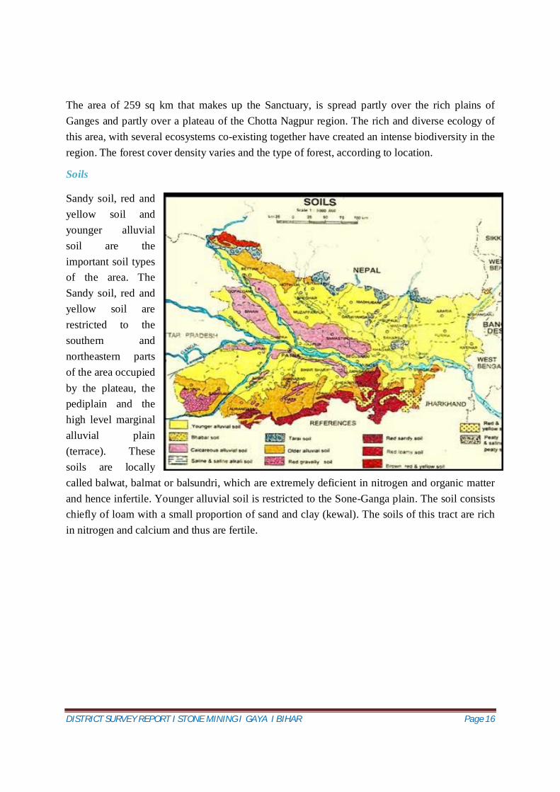
Soils
Sandy soil, red and yellow soil and younger alluvial soil are the important soil types of the area. The Sandy soil, red and yellow soil are restricted to the southern and northeastern parts of the area occupied by the plateau, the pediplain and the high level marginal alluvial plain (terrace). These soils are locally called balwat, balmat or balsundri, which are extremely deficient in nitrogen and organic matter and hence infertile. Younger alluvial soil is restricted to the Sone-Ganga plain. The soil consists chiefly of loam with a small proportion of sand and clay (kewal). The soils of this tract are rich in nitrogen and calcium and thus are fertile.
DISTRICT SURVEY REPORT I STONE MINING I GAYA I BIHAR Page 17
4. Geology of the District
Geology
The main geological formation of the region is of Quaternary age. The area is mostly covered by unconsolidated sediments which is known as alluvial deposits followed by consolidated deposits of Satpura range. Few areas are also characterized by units of Archaean ages. The Satpura range mainly exposed in Gaya hills and Rajgir hills comprises low grade supracrustals – Schists, ferruginous phyllite, quartzites and phyllitic slate. The Archeans are the oldest rock formation in the area. The most predominant rock type is gneisses and granites with basic intrusives and pegmatoides.The area is dominated by medium to fine sand geologically the area comprising of Terrace alluvium deposited in depositional terraces of old rivers & contain cyclic sequence of fine to course grained sand. It is angular to sub angular and the angularity of the grains of this category of sand decreases with depth.
The geology of the district can be divided as under –
GROUP FORMATION LITHOLOGY
Quaternary-Alluvium Recent Fine to Coarse sand ,clay , silt
Tertiary Sand Stones& Clay Stones North Champaran Hills
DISTRICT SURVEY REPORT I STONE MINING I GAYA I BIHAR Page 18
Gondwana Coal Measures, Forming a series of small outlier basins
Banka District
Vindhyans Sandstones, shales, Limestones etc.
Parts of Bahbhua and Rohtas Disricts
Satpura Schist,Phyllite,Quartzite Part of Aurangabad, Gaya, Nawada, Nalanda, Sheikhpura and Munger District
Proterozoic Schist, amphibolites, quartzite, granites, dolerites and pegmatites
Nawada, Jamui and Banka
Archaean Gneisses, Granites,Schists,Phyllites,quartzites, amphibolites & intrusive all metamorphosed sedimentary and igneous rocks
Part of Aurangabad ,Gaya, Nawada ,Jamui, Banka and Bhagalpur
DISTRICT SURVEY REPORT I STONE MINING I GAYA I BIHAR Page 19
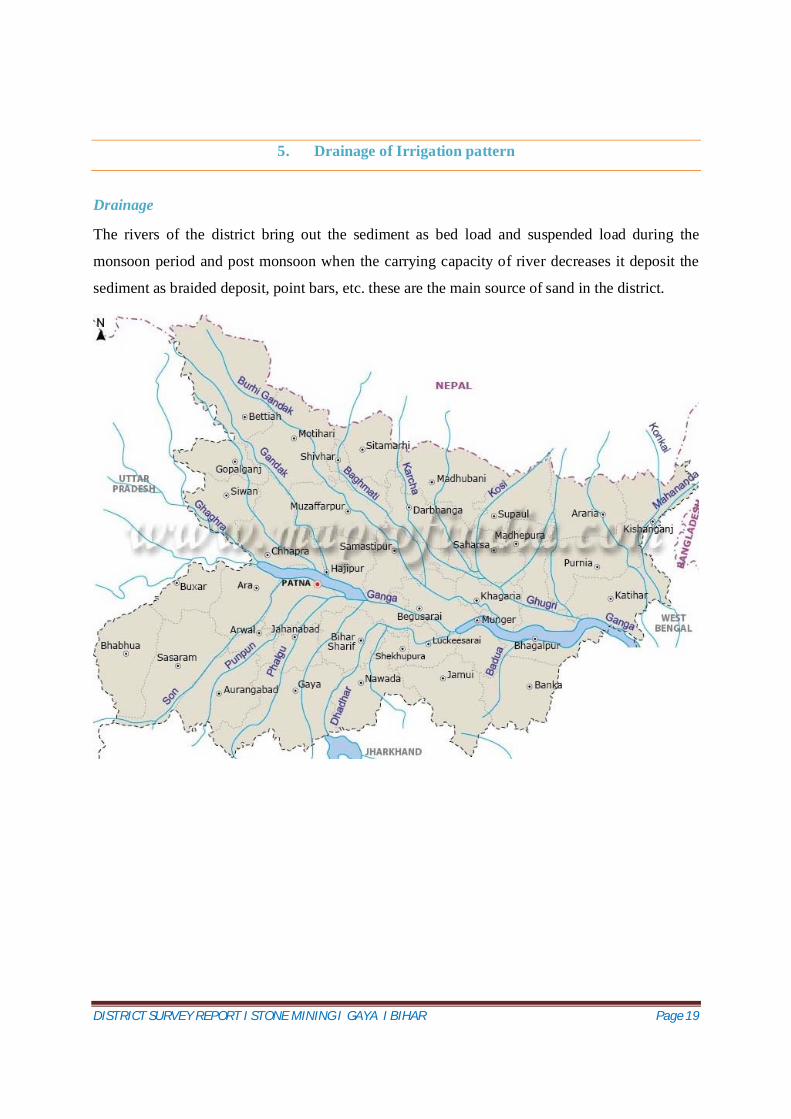
5. Drainage of Irrigation pattern
Drainage
The rivers of the district bring out the sediment as bed load and suspended load during the
monsoon period and post monsoon when the carrying capacity of river decreases it deposit the
sediment as braided deposit, point bars, etc. these are the main source of sand in the district.
DISTRICT SURVEY REPORT I STONE MINING I GAYA I BIHAR Page 20
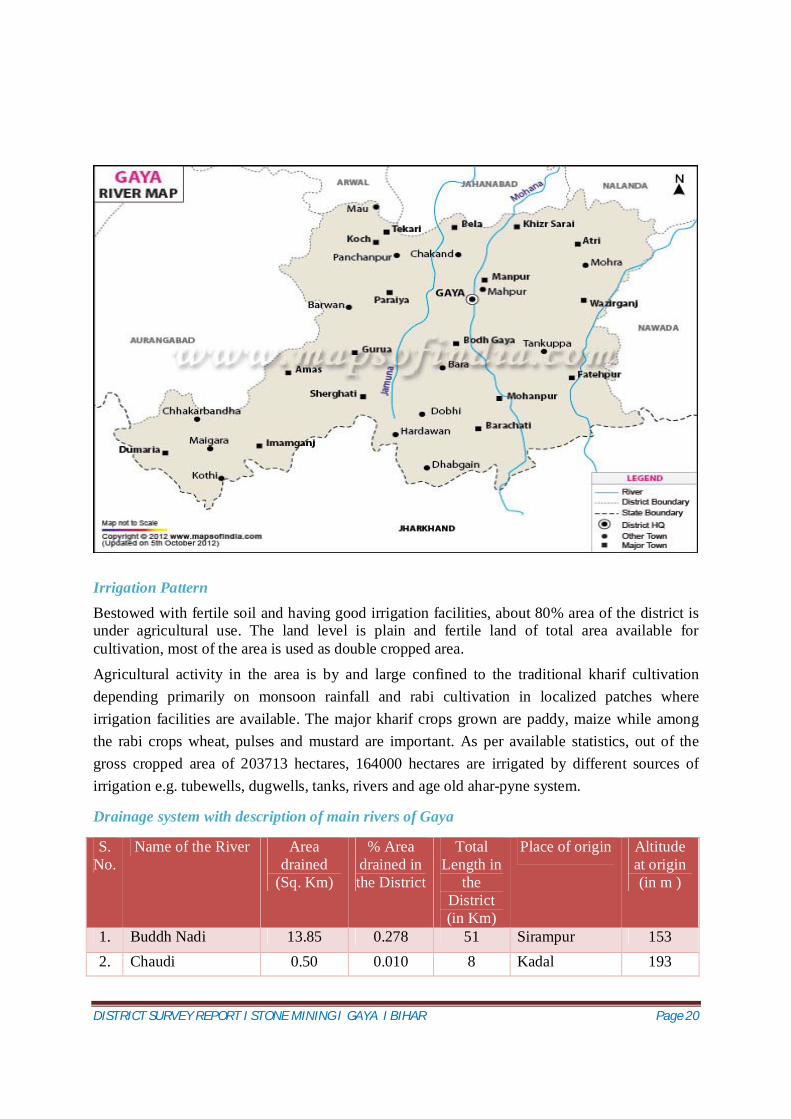
Irrigation Pattern Bestowed with fertile soil and having good irrigation facilities, about 80% area of the district is under agricultural use. The land level is plain and fertile land of total area available for cultivation, most of the area is used as double cropped area. Agricultural activity in the area is by and large confined to the traditional kharif cultivation depending primarily on monsoon rainfall and rabi cultivation in localized patches where irrigation facilities are available. The major kharif crops grown are paddy, maize while among the rabi crops wheat, pulses and mustard are important. As per available statistics, out of the gross cropped area of 203713 hectares, 164000 hectares are irrigated by different sources of irrigation e.g. tubewells, dugwells, tanks, rivers and age old ahar-pyne system.
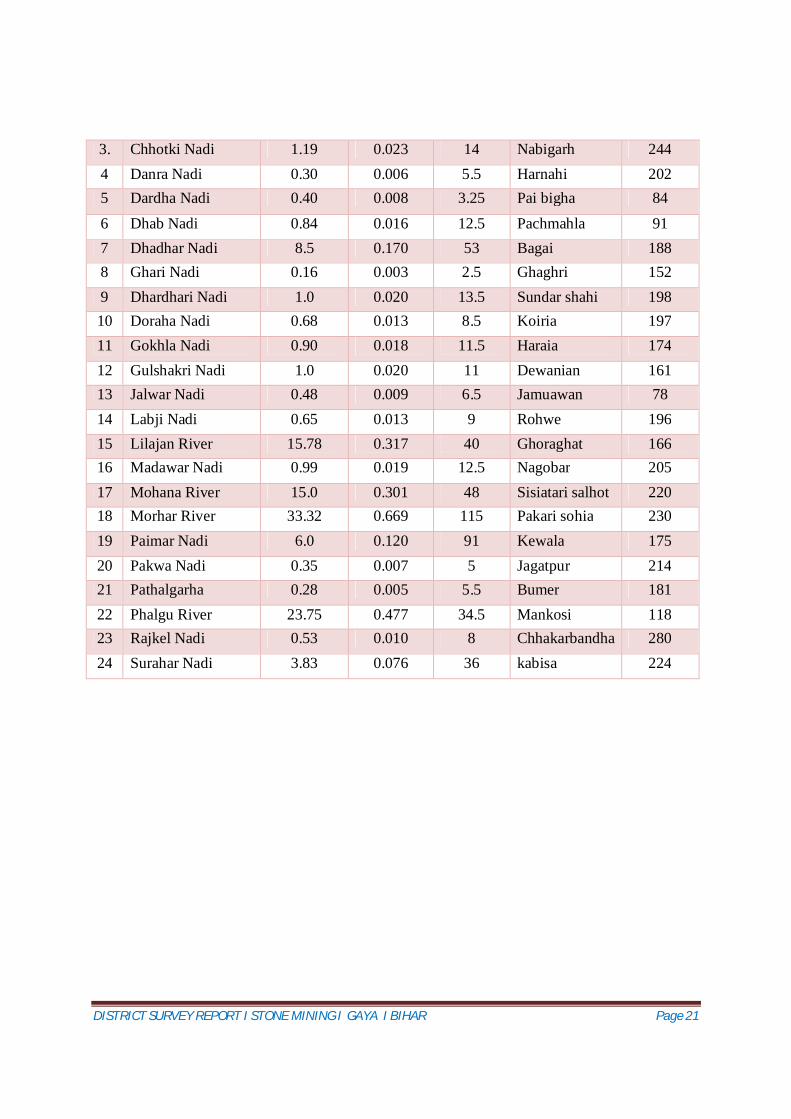
Drainage system with description of main rivers of Gaya
DISTRICT SURVEY REPORT I STONE MINING I GAYA I BIHAR Page 22
6. Land Utilization Pattern in the district
Forest
The forest cover of the district is 77836 hectares, which is 15.67% of total geographical area of the district. They belong to the category of reserve forests. The “Gautam Buddha Wildlife Sanctuary Gaya” is covering an area of 259.48sq.km and & protected forest area. It is established in the year 1976.
Agriculture
Agricultural activity in the area is by and large confined to the traditional kharif cultivation depending primarily on monsoon rainfall and rabi cultivation in localized patches where irrigation facilities are available. The major kharif crops grown are paddy, maize while among the rabi crops wheat, pulses and mustard are important. As per available statistics, out of the gross cropped area of 203713 hectares, 164000 hectares are irrigated by
different sources of irrigation e.g. tubewells, dugwells, tanks, rivers and age old ahar-pyne system.
DISTRICT SURVEY REPORT I STONE MINING I GAYA I BIHAR Page 23
Horticulture
Gaya district is under Low Level of Production in Horticultural Crops - The low level of horticultural development has found in the district.
These districts come under the periphery areas where there is a great lack of infrastructure regarding horticultural crops. Floriculture in the district is not developing in the same fashion as compared to other crops. So, there is need to emphasis on these crops. Horticulture cultivation is always advantageous. It paves the ways and means of development. It has been observed that it could be developed in the state if the government provides protection and subsidies to the farmers. There is a great need to emphasis on marketing management and boosting the irrigation resource of the state along with that there is need of awareness on profitability and techno managerial skill among farmers to promote the horticultural cultivation in the state.
01 LAND USE (sq.km.)
a) Forest area: 778.36 b) Net area sown: 1705.22
c) Total Cropped area: 2037.13 sq. km
02 AREA UNDER PRINCIPAL CROPS IRRIGATION BY DIFFERENT SOURCES (Area in ha, Govt. of Bihar 2008-09)
Area (ha)
Dug wells and Tube wells 1,20,,000 ha
Canal 5,000 ha
Net irrigated area 1,26,,000 ha
Gross irrigated area 1,64,000 ha
DISTRICT SURVEY REPORT I STONE MINING I GAYA I BIHAR Page 24
Mineral resources
The mineral resources of Gaya district playing massive role in industrial, social and economic development of the district. Available mineral resources in the district Sand Sandstones Quartzite Mica
Especially Sand mining and mica activities is playing a significant role industrial, social and economic development of the district.
DISTRICT SURVEY REPORT I STONE MINING I GAYA I BIHAR Page 25
7. Surface Water and Ground Water scenario of the district
Ground water Scenario
Water Bearing Formations
The district can be divided into two main units viz,
(A) Fissured formations, and
(B) Porous formations.
(A) Fissured formations: The ground water occurs under unconfined conditions in the weathered zone which acts as a good repository of groundwater. The thickness of weathered zone varies from 2.0 m to 10.0 m in high ground, and 10 m to 15 m in the low lying valley areas. A thin saproliticzone, varying in thickness from 0.5 m to 3 m, underlies these weathered and fractured zones. The ground water occurs under semi-confined condition in the fractures underlying the weathered formation. The movement of ground water is controlled by joints, fissures and other planes of structural weakness, and is dependent on the extent, size, openings, continuity and interconnections of fractures.. They form potential repositories of groundwater in the fissured rocks consisting of granite gneisses, mica-schist, quartzite and other associated rocks of Pre-Cambrian age. The boreholes drilled by C.G.W.B. in the hard rock terrain have tapped fractures at variable depth from 14 m. to 98 m. The yield was observed to vary 2.6 m 3 /hr to 35.67 m 3 /hr at a reasonable drawdown (Table). The transmissivity of fractures within 100 m depth in granite gneiss varies from 126 m 2 /day to 168 m 2 /day and the storativity varies from 1.2*10-3 to 1.4*10-5 . In Gaya district, altogether 11exploratory wells and 9 observation wells have been drilled to decipher the potential fracture zones in hard rock formation. The exploratory results reveal that the lineaments trending NS and NE-SW are potential from the ground water point of view.
B) Porous Formation: The Quaternary alluvium occurring in the central valley (Dobhi-Gaya terrace) as well as the Sone-Ganga plain constitute this hydrogeological unit. It consists of alluvial sediments, made up of gravels, sands, silt and clays. The gravel and medium to coarse-grained sand layers are good groundwater repositories. The thickness of the alluvium deposit is nearly 30-50 m, but the actual thickness of the aquifer varies from 15 m to 20 m. In the alluvium the ground water is under water-table condition. It can sustain a yield of 25 m3 /hr to 40 m3 /hr on an average. The exploratory drilling in Gaya district is confined to hard rock areas only. The results show that there exist good ground water development prospect in the district up to 100 m depth. Shallow bore wells of 50 m depth yield 10-15 m3 /hr of fresh ground water. The deeper bore-wells of 100 m depth may yield of 15-30 m3 /hr. The sub surface correlation aquifer indicates increase in thickness of sandy horizon eastwards towards river Falgu.
DISTRICT SURVEY REPORT I STONE MINING I GAYA I BIHAR Page 26
Hydrogeological Map of Gaya District
Source: Centre for Ground Water Board (CGWB)
Depth to water level
In order to assess the temporal and spatial behavior of ground water levels over the years 10
ground water monitoring wells were monitored during pre- and post-monsoon periods in the
year 2011.
From the study of the depth to water map, it is evident that ground water level during pre-
monsoon period mainly varies between 5-10 m below ground level in the major part of the
district. Deeper ground water levels (>10m) were observed in the eastern and western parts
of the district.
DISTRICT SURVEY REPORT I STONE MINING I GAYA I BIHAR Page 27
From the study of the depth to water map, it is conspicuous that ground water level during
post-monsoon period mainly varies between 2-5 m below ground level in the major part of
the district. Deeper ground water levels (5-10) were observed over a small patch in the
central part of the district.
Depth to Water Level (Pre-Monsoon) Map Depth to Water Level (Post-Monsoon) Map
Ground Water Quality
Ground water in the phreatic aquifers in Gaya district is slightly alkaline in nature. The
specific conductance of ground water in phreatic zone during pre-monsoon, 2011 was in the
range of 460 -1350 µS/cm at 25ºC. The suitability of ground water for drinking purpose has
been evaluated on the basis of pH, Total hardness (T.H), Ca, Mg Cl, etc. The chemical
concentration of these constituents, when compared with the drinking water specification
recommended by IS: 10500, 1991 indicates that in one samples from HNS at Wazirganj Ca
(Calcium) exceeded the required permissible limit of 75 mg/l. Magnesium was found to have
exceeded the required permissible limit of 30 mg/l at Bodh Gaya, Dobhi and Sherghati.
Ground Water Resources
The net annual replenishable ground water resource of Gaya district as on 31st March 2009 works out to be 104634 ha.m. The gross annual draft for all uses works out to be 50664 ha.m.
DISTRICT SURVEY REPORT I STONE MINING I GAYA I BIHAR Page 28
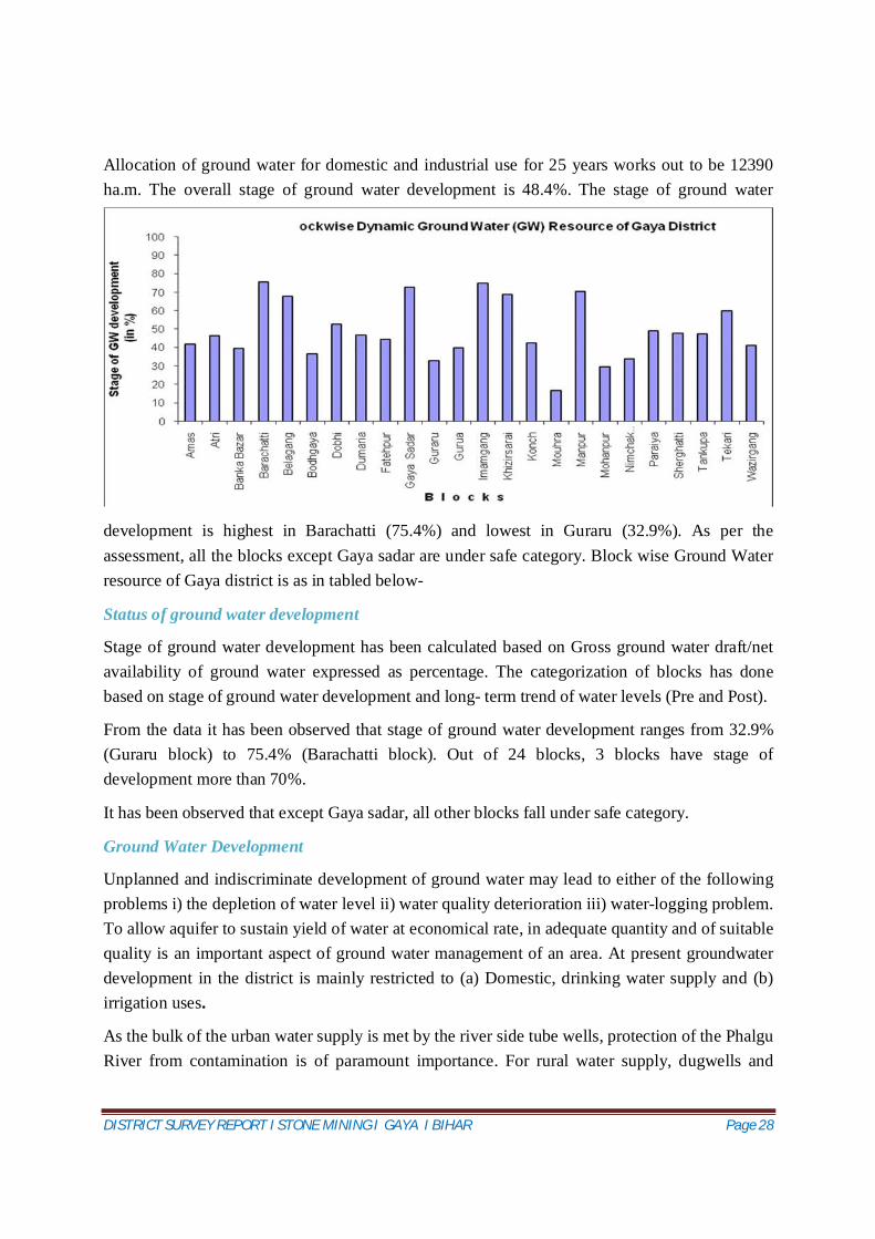
Allocation of ground water for domestic and industrial use for 25 years works out to be 12390 ha.m. The overall stage of ground water development is 48.4%. The stage of ground water
development is highest in Barachatti (75.4%) and lowest in Guraru (32.9%). As per the assessment, all the blocks except Gaya sadar are under safe category. Block wise Ground Water resource of Gaya district is as in tabled below-
Status of ground water development
Stage of ground water development has been calculated based on Gross ground water draft/net availability of ground water expressed as percentage. The categorization of blocks has done based on stage of ground water development and long- term trend of water levels (Pre and Post).
From the data it has been observed that stage of ground water development ranges from 32.9% (Guraru block) to 75.4% (Barachatti block). Out of 24 blocks, 3 blocks have stage of development more than 70%.
It has been observed that except Gaya sadar, all other blocks fall under safe category.
Ground Water Development
Unplanned and indiscriminate development of ground water may lead to either of the following problems i) the depletion of water level ii) water quality deterioration iii) water-logging problem. To allow aquifer to sustain yield of water at economical rate, in adequate quantity and of suitable quality is an important aspect of ground water management of an area. At present groundwater development in the district is mainly restricted to (a) Domestic, drinking water supply and (b) irrigation uses.
As the bulk of the urban water supply is met by the river side tube wells, protection of the Phalgu River from contamination is of paramount importance. For rural water supply, dugwells and
DISTRICT SURVEY REPORT I STONE MINING I GAYA I BIHAR Page 29
Mark II/III hand pumps or cylinder fitted tube wells/ bore wells may be sunk in villages and rural towns across the district.
Shallow tubewells/ borewells and dug cum bored wells are being used for raising crops like wheat, mustard etc. The gross ground water draft for the area has been estimated as 50664 ham.
In the district, large diameter dugwells and dug cum bored wells are the most feasible ground water structures.
Water Conservation and Artificial Recharge:
In urban areas, rain water available from roof tops of buildings, paved and unpaved areas goes waste. The rain water harvesting system needs to be designed in such a way that it does not occupy large space for collection and recharge system. A few techniques of roof top rain water harvesting in urban areas are as follow:
(i) Roof Top Rain Water Harvesting Through Recharge Pit.
(ii) Roof Top Rain Water Harvesting Through Existing Tubewells/Dug Wells
(iii) Roof Top Rain Water Harvesting Through Trench with Recharge Well
In areas where the surface soil is impervious and large quantities of roof water or surface runoff is available within a very short period of heavy rainfall, the use of trench/pits is made to store the water in a filter media and subsequently recharge to groundwater through specially constructed recharge wells.
This technique is ideally suited for area where permeable horizon is within 3 m below ground level.
Recharge well of 100-300 mm diameter is constructed; based on the lithology of the area well assembly is designed with slotted pipe against the shallow and deeper aquifer.
If the aquifer is available at greater depth say more than 20 m, a shallow shaft of 2 to 5 m diameter and 3-5 metres deep may be constructed depending upon availability of runoff. Inside the shaft a recharge well of 100-300 mm dia is constructed for recharging the available water to the deeper aquifers. At the bottom of the shaft a filter media is provided to avoid choking of recharge well.
In rural areas especially in the upland part of the district, which forms the catchment area for
the streams, contour bunding, percolation tanks, gully plugs, sub surface dykes, nala bund/
check dams on perennial streams may be constructed.
DISTRICT SURVEY REPORT I STONE MINING I GAYA I BIHAR Page 30
8. Rainfall of the district and Climate condition
The area experiences a continental monsoon type of climate owing to its great distance from the
sea. The climate is extreme and comprises three broad seasons-the summer, the monsoon and the
winter. The summer months from the middle of March to May are characterized by hot blasts of
westerly winds commonly known as ‘loo’. The peak of summer is in May when mercury shoots
to 460C. The cold spell starts from December and continues till end of February. During this
period the mercury drops down to as low as 40 C.
The climate in Gaya is warm and temperate. In winter, there is much less rainfall than in summer. This location is classified as Cwa by Köppen and Geiger. The average temperature in Gaya is 26.5 °C. The rainfall here averages 1105 mm.
Climograph /Weather by Month Gaya
The driest month is December, with 4 mm of rain. Most precipitation falls in August, with an average of 326 mm.
DISTRICT SURVEY REPORT I STONE MINING I GAYA I BIHAR Page 31
Average Temperatures Gaya
May is the warmest month of the year. The temperature in May averages 34.1 °C. In January, the average temperature is 17.7 °C. It is the lowest average temperature of the whole year.
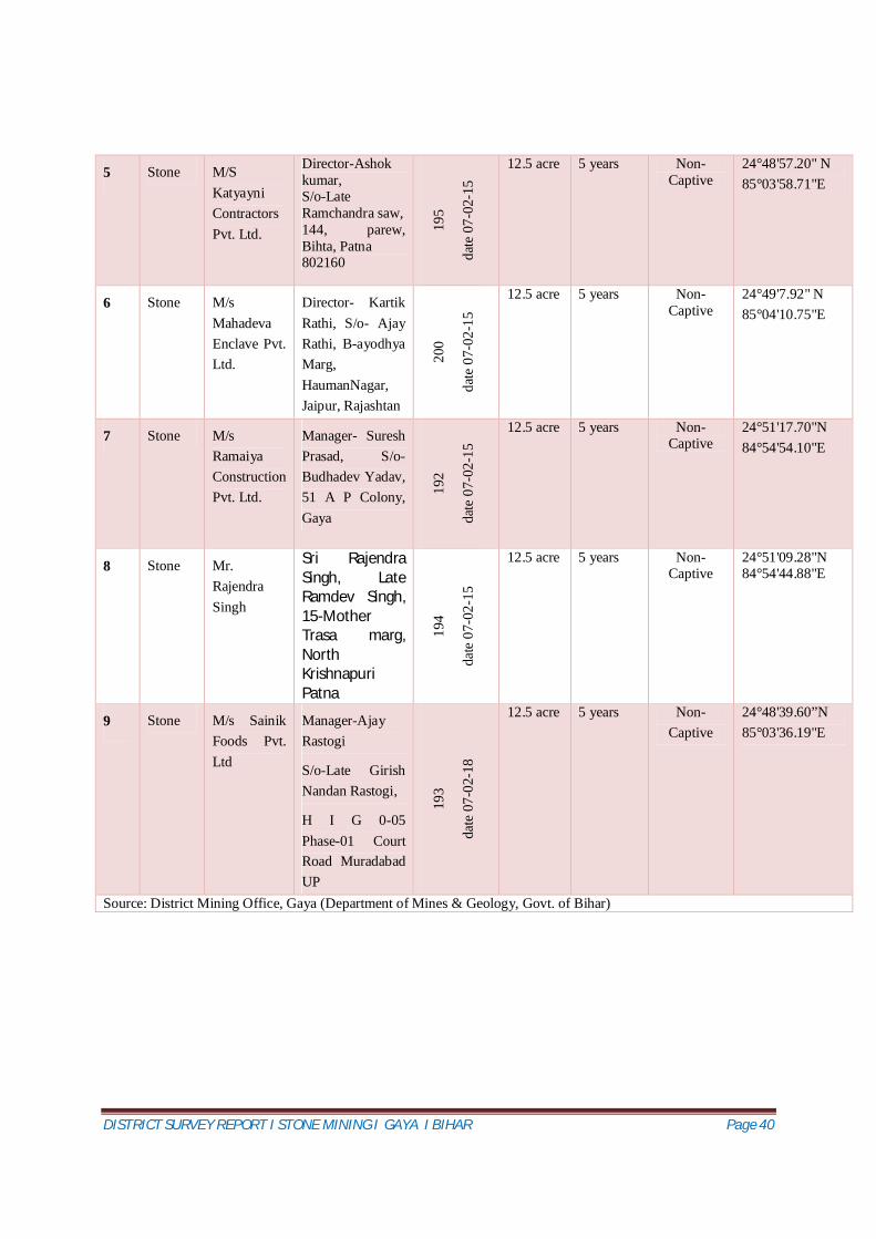
Manager- Suresh Prasad, S/o- Budhadev Yadav, 51 A P Colony, Gaya
192
date
07-
02-1
5
12.5 acre 5 years Non- Captive
24°51'17.70"N 84°54'54.10"E
8 Stone Mr. Rajendra Singh
Sri Rajendra Singh, Late Ramdev Singh, 15-Mother Trasa marg, North Krishnapuri Patna
194
date
07-
02-1
5
12.5 acre 5 years Non- Captive
24°51'09.28"N 84°54'44.88"E
9 Stone M/s Sainik Foods Pvt. Ltd
Manager-Ajay Rastogi
S/o-Late Girish Nandan Rastogi,
H I G 0-05 Phase-01 Court Road Muradabad UP
193
date
07-
02-1
8
12.5 acre 5 years Non- Captive
24°48'39.60”N 85°03'36.19"E
Source: District Mining Office, Gaya (Department of Mines & Geology, Govt. of Bihar)
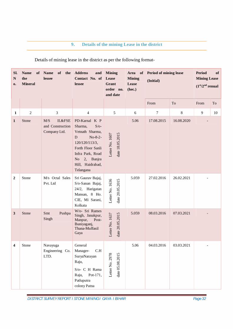
DISTRICT SURVEY REPORT I STONE MINING I GAYA I BIHAR Page 41
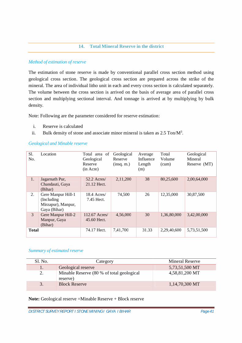
14. Total Mineral Reserve in the district
Method of estimation of reserve
The estimation of stone reserve is made by conventional parallel cross section method using geological cross section. The geological cross section are prepared across the strike of the mineral. The area of individual litho unit in each and every cross section is calculated separately. The volume between the cross section is arrived on the basis of average area of parallel cross section and multiplying sectional interval. And tonnage is arrived at by multiplying by bulk density.
Note: Following are the parameter considered for reserve estimation:
i. Reserve is calculated ii. Bulk density of stone and associate minor mineral is taken as 2.5 Ton/M3.
Geological and Minable reserve
Sl. No.
Location Total area of Geological Reserve (in Acre)
Geological Reserve (insq. m.)
Average Influence Length (m)
Total Volume (cum)
Geological Mineral Reserve (MT)
1. Jagarnath Pur, Chandauti, Gaya (Bihar)
52.2 Acres/ 21.12 Hect.
2,11,200 38 80,25,600 2,00,64,000
2. Gere Manpur Hill-1 (Including Mirzapur), Manpur, Gaya (Bihar)
18.4 Acres/ 7.45 Hect.
74,500 26 12,35,000 30,87,500
3 Gere Manpur Hill-2 Manpur, Gaya (Bihar)
112.67 Acres/ 45.60 Hect.
4,56,000 30 1,36,80,000 3,42,00,000
Total 74.17 Hect. 7,41,700 31.33 2,29,40,600 5,73,51,500
Summary of estimated reserve
Sl. No. Category Mineral Reserve 1. Geological reserve 5,73,51,500 MT 2. Minable Reserve (80 % of total geological
DISTRICT SURVEY REPORT I STONE MINING I GAYA I BIHAR Page 42
15. Quality/ Grade of Mineral available in the district
The deposit in the area is quite good in respect of quality and quantity. Quality of Sand Stone available in the district is of intermediate. Rock has intergrown quartz grains, thus is massive and hard. Protolith is sandstone. Intermediate to high grade metamorphism. The Sand Stone mineral can be used as boulders of different sizes for dam construction, embankment works etc. After crushing into different sizes it can be used in construction and road projects.
Limestone or dolomite is also found is the district. Coarse-grained recrystallized limestone or dolomite is typically harder than the protolith. It May have dark bands due to organic impurities.
DISTRICT SURVEY REPORT I STONE MINING I GAYA I BIHAR Page 43
16. Use of Mineral
ROM will be used for construction of buildings & making of road. Stone can be used in different form of different construction jobs and road projects. Stone, mined out from the mine, can be directly used as boulders of different sizes for dam construction, embankment works etc. After crushing into different sizes of aggregates, ranging from 6mm to 63mm, the product can be used in construction and road projects.
Uses of different stone mineral.
Uses of Sand stones
Building and decorative stone
Aggregates.
dam construction, embankment works
Industrial purposes
Uses of Lime stone
It is the raw material for the manufacture of quicklime (calcium oxide), slaked lime(calcium hydroxide), cement and mortar.
Pulverized limestone is used as a soil conditioner to neutralize acidic soils.
Is crushed for use as aggregate—the solid base for many roads as well as in asphalt concrete.
Geological formations of limestone are among the best petroleum reservoirs;
As a reagent in flue-gas desulfurization, it reacts with sulfur dioxide for air pollution control.
Glass making, in some circumstances, uses limestone.
It is added to toothpaste, paper, plastics, paint, tiles, and other materials as both white pigment and a cheap filler.
It can suppress methane explosions in underground coal mines.
Purified, it is added to bread and cereals as a source of calcium.
Calcium levels in livestock feed are supplemented with it, such as for poultry.
DISTRICT SURVEY REPORT I STONE MINING I GAYA I BIHAR Page 44
It can be used for re-mineralizing and increasing the alkalinity of purified water to prevent pipe corrosion and to restore essential nutrient levels.
Used in blast furnaces, limestone binds with silica and other impurities to remove them from the iron.
It is used in sculptures because of its suitability for carving.
Uses of Sulphur
The main use of sulphur is in the preparation of SO2 which is used in the manufacture of sulphuric acid.
Sulphur is used in the manufacture of carbon disulphate, sodium thiosulphate, gun powder, matches and in fireworks.
Sulphur is used as fungicide and insecticide in agriculture and as a disinfectant in medicines.
Sulphur is used in ointments for curing skin diseases.
Sulphur is used in beauty parlors to give specific shapes to the hair.
Uses of Pyrite
Pyrite used to be an important ore for the production of sulfur and sulfuric acid.
Pyrite is occasionally used as a gemstone. It is fashioned into beads, cut into cabochons, faceted, and carved into shapes.
A newer commercial use for pyrite is as the cathode material in Energizer brand non-rechargeable lithium batteries.
Uses of Dolomites
Dolomite is used as an ornamental stone, a concrete aggregate, and a source of magnesium oxide, as well as in the Pidgeon process for the production of magnesium
Dolomite is sometimes used in its place as a flux for the smelting of iron and steel.
Large quantities of processed dolomite are used in the production of float glass.
In horticulture, dolomite and dolomite limestone are added to soils and soilless potting mixes as a pH buffer and as a magnesium source.
Calcined dolomite is also used as a catalyst for destruction of tar in the gasification of biomass at high temperature.
DISTRICT SURVEY REPORT I STONE MINING I GAYA I BIHAR Page 45
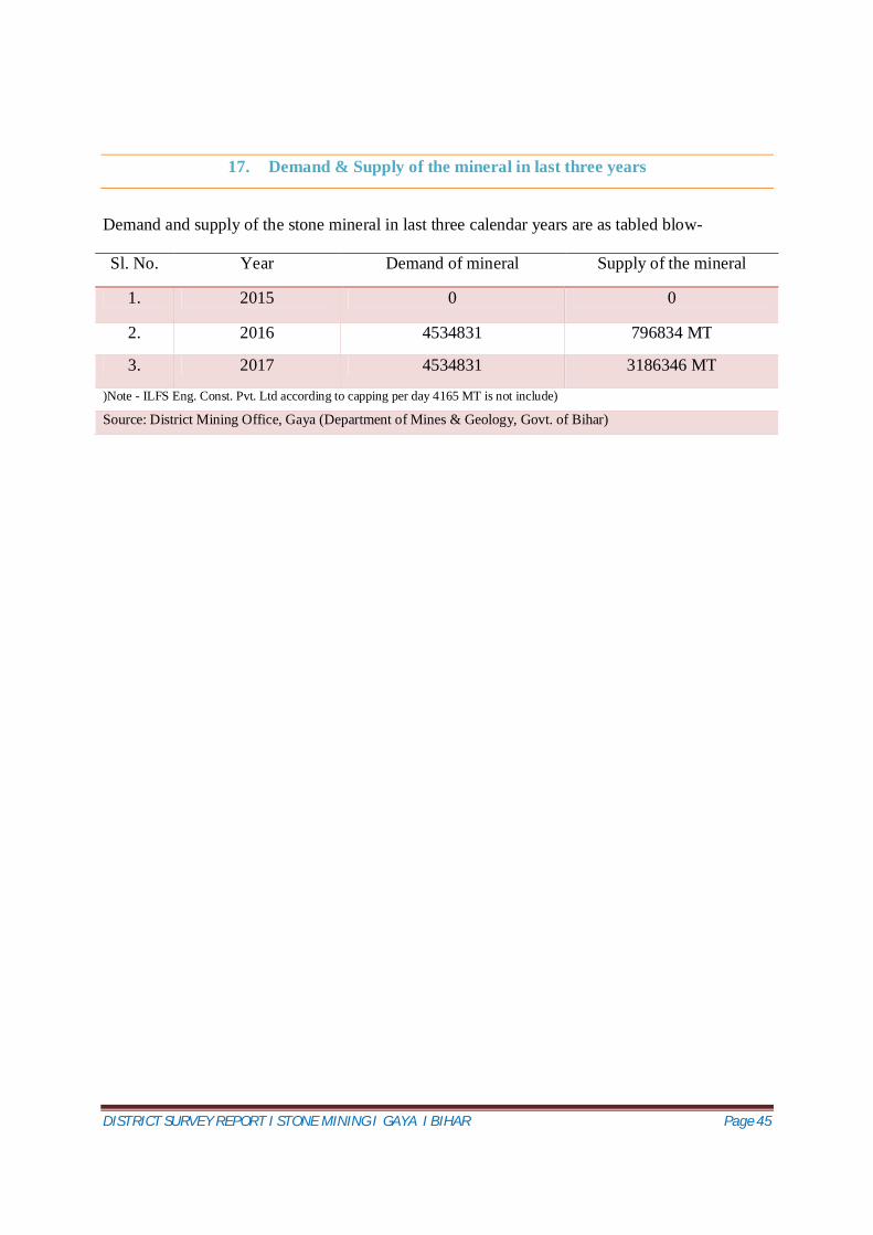
17. Demand & Supply of the mineral in last three years
Demand and supply of the stone mineral in last three calendar years are as tabled blow-
Sl. No. Year Demand of mineral Supply of the mineral
1. 2015 0 0
2. 2016 4534831 796834 MT
3. 2017 4534831 3186346 MT
)Note - ILFS Eng. Const. Pvt. Ltd according to capping per day 4165 MT is not include)
Source: District Mining Office, Gaya (Department of Mines & Geology, Govt. of Bihar)
DISTRICT SURVEY REPORT I STONE MINING I GAYA I BIHAR Page 46
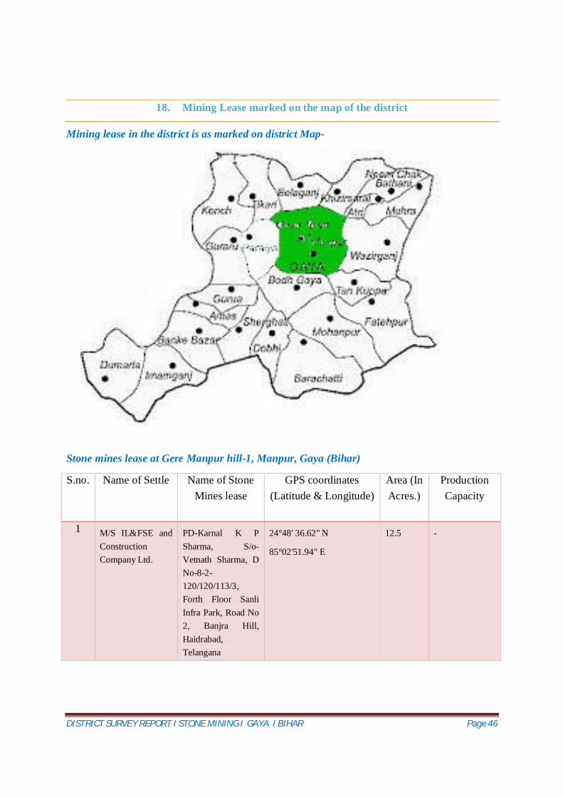
18. Mining Lease marked on the map of the district
Mining lease in the district is as marked on district Map-
Stone mines lease at Gere Manpur hill-1, Manpur, Gaya (Bihar)
S.no. Name of Settle Name of Stone Mines lease
GPS coordinates (Latitude & Longitude)
Area (In Acres.)
Production Capacity
1 M/S IL&FSE and Construction Company Ltd.
PD-Karnal K P Sharma, S/o-Vetnath Sharma, D No-8-2-120/120/113/3, Forth Floor Sanli Infra Park, Road No 2, Banjra Hill, Haidrabad, Telangana
24°48' 36.62" N
85°02'51.94" E
12.5 -
DISTRICT SURVEY REPORT I STONE MINING I GAYA I BIHAR Page 47
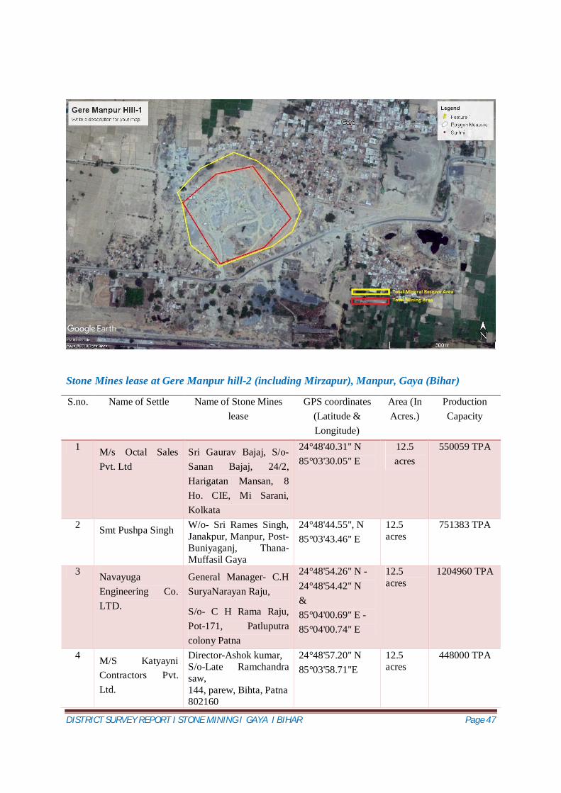
Stone Mines lease at Gere Manpur hill-2 (including Mirzapur), Manpur, Gaya (Bihar)
S.no. Name of Settle Name of Stone Mines lease
GPS coordinates (Latitude & Longitude)
Area (In Acres.)
Production Capacity
1 M/s Octal Sales Pvt. Ltd
Sri Gaurav Bajaj, S/o-Sanan Bajaj, 24/2, Harigatan Mansan, 8 Ho. CIE, Mi Sarani, Kolkata
24°48'40.31" N 85°03'30.05" E
12.5 acres
550059 TPA
2 Smt Pushpa Singh W/o- Sri Rames Singh, Janakpur, Manpur, Post- Buniyaganj, Thana-Muffasil Gaya
24°48'44.55", N 85°03'43.46" E
12.5 acres
751383 TPA
3 Navayuga Engineering Co. LTD.
General Manager- C.H SuryaNarayan Raju,
S/o- C H Rama Raju, Pot-171, Patluputra colony Patna
24°48'54.26" N -24°48'54.42" N & 85°04'00.69" E -85°04'00.74" E
DISTRICT SURVEY REPORT I STONE MINING I GAYA I BIHAR Page 49
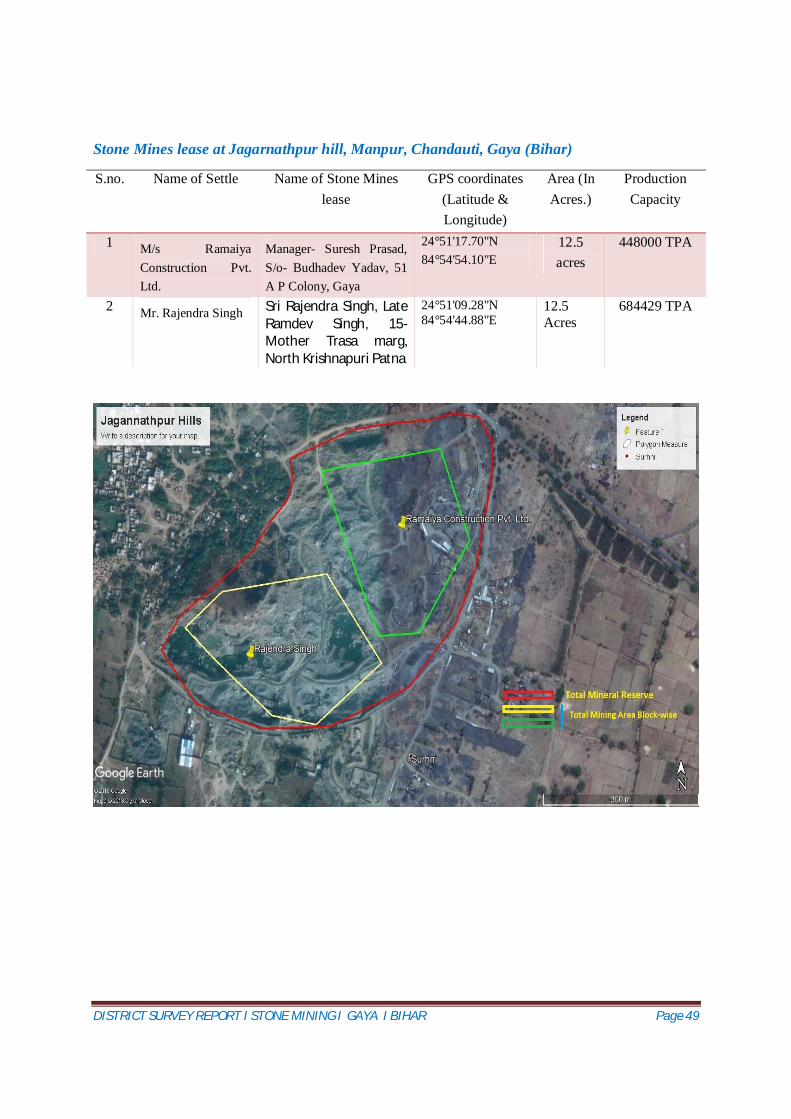
Stone Mines lease at Jagarnathpur hill, Manpur, Chandauti, Gaya (Bihar)
S.no. Name of Settle Name of Stone Mines lease
GPS coordinates (Latitude & Longitude)
Area (In Acres.)
Production Capacity
1 M/s Ramaiya Construction Pvt. Ltd.
Manager- Suresh Prasad, S/o- Budhadev Yadav, 51 A P Colony, Gaya
24°51'17.70"N 84°54'54.10"E
12.5 acres
448000 TPA
2 Mr. Rajendra Singh Sri Rajendra Singh, Late Ramdev Singh, 15-Mother Trasa marg, North Krishnapuri Patna
24°51'09.28"N 84°54'44.88"E
12.5 Acres
684429 TPA
DISTRICT SURVEY REPORT I STONE MINING I GAYA I BIHAR Page 50
19. Details of cluster of mining lease viz. number of mining lease location (Lat. and long.)
Cluster-1 at Gere Manpur hill-2 (including Mirzapur), Manpur, Gaya (Bihar)
S.no. Name of Settle GPS coordinates (Latitude & Longitude)
Area (In Acres.)
1 M/s Octal Sales Pvt. Ltd 24°48'40.31" N 85°03'30.05" E
12.5 acres
2 Smt Pushpa Singh 24°48'44.55”N 85°03'43.46" E
12.5 acres
3 Navayuga Engineering Co. LTD. 24°48'54.26" N -24°48'54.42" N & 85°04'00.69" E 85°04'00.74" E
12.5 acres
4 M/S Katyayni Contractors Pvt. Ltd. 24°48'57.20" N 85°03'58.71"E
12.5 acres
5 M/s Mahadeva Enclave Pvt. Ltd. 24°49'7.92" N 85°04'10.75"E
12.5 acres
6 M/s Sainik Foods Pvt. Ltd 24°48'39.60”N 85°03'36.19"E
12.5 acres
Cluster-2 at Jagarnathpur hill, Manpur, Chandauti, Gaya (Bihar)
S.no. Name of Settle GPS coordinates (Latitude & Longitude)
Area (In Acres.)
1 M/s Ramaiya Construction Pvt. Ltd. 24°51'17.70"N 84°54'54.10"E
12.5 acres
2 Mr. Rajendra Singh 24°51'09.28"N 84°54'44.88"E
12.5 Acres
DISTRICT SURVEY REPORT I STONE MINING I GAYA I BIHAR Page 51
20. Eco-Sensitive area in the district
In Gaya district only one eco-sensitive area present i.e. Gautam Buddha Wildlife Sanctuary. The Gautam Buddha Wildlife Sanctuary, situated in Gaya District of Bihar and Koderma and Chatra Districts of Jharkhand is spread over an area of 259.46 square kilometres ( 138.33 square kilometres in Gaya District in State of Bihar) and is ecologically significant and known for wildlife; whereas, the flora and fauna represent rich biological significance of this sanctuary;
and whereas, Leopard, Sloth Bear, Cheetal, Sambar, Nilgai, Wild Boar, Hyena, Jackal, Wolf, Jungle fowl, Python etc., endangered species inhabit this sanctuary; the protected area of Gautam Buddha Wildlife Sanctuary as Eco-sensitive Zone from ecological, environmental and biodiversity point of view and to prohibit industries or class of industries and their operations and processes in the said Eco-sensitive Zone.
Now therefore, in exercise of the powers conferred by sub-section(1) and clauses (v) and (xiv) of subsection (2) and sub-section (3) of section 3 of the Environment (Protection) Act, 1986 (29 of 1986) read with sub-rule (3) of rule 5 of the Environment (Protection) Rules, 1986, the Central Government hereby notifies the area to an extent varying upto one kilometer around the boundary of Gautam Buddha Wildlife Sanctuary in the State of Bihar as the Gautam Buddha Wildlife Sanctuary Eco-sensitive Zone.
The area of Eco-sensitive Zone shall be 149.25 square kilometers with an extent up to one kilometer on Bihar side around the Gautam Buddha Wildlife Sanctuary.
The 37 villages falling within the eco-sensitrive zone around Gautama Buddha wildlife sanctuary.
There is no settlement in two kilometer radius. Eco Sensitive Zone lies around 50 Kilometers in south direction from the mining location. Geo-Coordinates of Boundary of Gautam Budhha Wildlife Sanctuary of Gaya District Points GPS Coordinates Points GPS Coordinates
1 24°22' 47.069" N 84°56' 14.729" E 8 24°32' 21.856" N 85°13' 28.173" E
2 24°24' 55.425" N 84°56' 58.003" E 9 24°28' 19.018" N 85°14' 14.322" E
3 24°25' 16.439" N 84°57' 32.155" E 10 24°27' 47.665" N 85°13' 34.075" E
4 24°25' 52.150" N 84°57' 53.497" E 11 24°27' 59.548" N 85°12' 35.696" E
5 24°27' 12.243" N 84°59' 48.232" E 12 24°23' 46.266" N 85°7' 2.116" E
6 24°30' 46.658" N 85°5' 0.230" E 13 24°25' 56.820" N 85°4' 46.973" E
7 24°33' 52.263" N 85°10' 35.979" E 14 24°22' 29.392" N 84°58' 30.428" E
DISTRICT SURVEY REPORT I STONE MINING I GAYA I BIHAR Page 52
21. Impact on the Environment due to mining activity
Impact on Environment due to mining activities varies based on the quantum of production rate proposed. The different activities involved before & during mining are narrated below, which helps to assess the impact on environment.
Population growth, economic development and environmental degradation are interlinked with each-other. The high growth in population speeds-up economic activities. Meanwhile, it also deteriorates environment as for the high level of economic development, plenty of natural resources are exploited. Similarly, mining activities have considerable impacts on environment. The most important environmental problems from the mining activities are mercury pollution, cyanide pollution, direct dumping of tailing and affluent into river. These environmental problems from mining activities are the global phenomena. It does not only degrade the land and forest areas but also, it affects the air, water and health qualities. Faunal and floral depletion, due to mining activities, is also enormous.
Land degradation is one of the significant impacts arising out of mining and quarrying activity which is mainly in the form of alternation of land structure due to excavation, stacking of top soil and loss of land due to dumping of mine waste and overburden soil. Stone and sand quarrying causes damage to property, depletion of ground water, loss of fertile top soil, degradation of forest land, adverse effect on the biodiversity and public health.
Mining and quarrying, either open cast or underground, destroys landscape and forest ecosystems. The waste materials that remain after the extraction of usable ores are dumped on the surrounding land, thus causing loss of top soil, nutrients and supportive micro flora and vegetation.
Air pollution, due to dust from the mines, is a common environmental problem in mines and quarries especially open cast operations. Stone Mining activities are normally associated with different types of pollution. Air pollution is regarded as the most notable one, where particulate matter (dust) are generated and found in the surrounding areas of such activities. Particles with aerodynamic diameters of less than 50µm (termed Total Suspended Particulate matter, or TSP) can become suspended in the atmosphere, and those with aerodynamic diameters of less than 10µm termed PM10 (inhalable particles) can be transported over long distances, and enter the human respiratory system.
Noise pollution is associated with many types of equipment used in mining operations, but blasting is considered the major source. Loud sound disturbed the vegetable nearby the area.It also affect stability of infrastructures, buildings, and homes of people living near to these working sites. In this regard, noise pollution may include noise from vehicle engines, loading and unloading of rock into steel dumpers, chutes, power generation, and other sources.
DISTRICT SURVEY REPORT I STONE MINING I GAYA I BIHAR Page 53
Mining operations impact the environment in several ways, and water pollution is a major concern in such operations. For instance quarry dust can change the chemistry of water resources by dissolving in them, it can also settle in water bodies and cause pollution.Furthermore, these operations disrupt the existing movement of surface water and groundwater; they interrupt natural water recharge and can lead to reduced quantity and quality of drinking water for residents and wildlife near or downstream from a quarry site.
The pollution potential of the proposed project, it is possible impacts on the surrounding
environment during pre-operational and operational phases and the necessary management
actions proposed for control and abatement of pollution are furnished hereunder.
Impact on the some component of the environment are as below-
Air environment
Although mining does not cause any direct change in air environment, transportation etc. In
stone mining operations, the source of air pollution may cause deterioration of air quality due to
the fugitive dust emission during blasting, scooping, loading-unloading operations and
transportation. Loading and unloading of mineral would be associated with the fugitive emission
in the active area whereas fugitive emission during transportation would affect the areas/villages
situated adjacent to road side. Another source of air pollution would be emission from the
trucks/tractor/other vehicles to be used for transportation of soil.
Water environment
As far as impact on surface water is concerned, during mining and transportation, there are
chances of contamination of surface water resources (pond, well etc.) with dust or by other
means. The labourers working in stone mining come from neighboring districts and colonise in
the surrounding areas with inadequate facilities for waste disposal. This, in due course, leads to
disposal of various things into surface water bodies which in due course of time results into
surface water contamination through misuse / mismanagement and decomposition of the trash.
Land environment
There shall be no major impacts of stone mining on land due to rocky terrain having no soil
cover generation of top soil shall be nil.
DISTRICT SURVEY REPORT I STONE MINING I GAYA I BIHAR Page 54
Other impacts on land include Disposal of packing material, carried by the workers. This packing
material would include used sachet/gutka/pan masala pouches. Polythene bag used by the
workers to bring their foods etc.
Noise environment
As far as noise pollution is concerned, blasting is considered the major source of noise pollution.
The Machinery used in mining of stone mineral create sound and vibrates. As well as vehicles
used for transport, loading-unloading of mineral etc. put impact on noise environment. Noise
level in the working environment should be compared with the standards prescribed by Central
Pollution Control Board which has been adopted and enforced by the Govt. of India through The
Noise Pollution (Regulation and Control) Rules, 2000.
Flora and Fauna
The mining is a destructive activity generated by human being for providing strength and
security to his living standard. The mining in the concerned zones provides raw materials in the
form of crusher, gravels and stones, etc. for construction of roads, railway lines and other
infrastructures. From the last few years the mining rate has increased several times. It results in
the loss of biodiversity of both flora and fauna and physiographic features of the concerned
region.
DISTRICT SURVEY REPORT I STONE MINING I GAYA I BIHAR Page 55
22. Remedial measure to mitigate the impact of mining on the environment
Air environment
Mitigation Measures
For Fugitive Dust Emission:
• All trucks should be covered by tarpaulin sheet to prevent dust emission.
• Water spraying should be there in haul road, crusher and mining area.
• Wet drilling should be preferred
• Sharp drill rods should be used to reduce dust generation
• Dust extractor should be used to reduce dust generation
For Vehicular Emission
• Overloading of trucks and trolleys should be prevented.
• Vehicular emission can pose serious health hazard. During the earth mining extraction, tractor/truck should be used for transportation. Tractor/truck comprises of diesel engine produce particles are dangerously fine of PM10 & PM2.5. It is well known fact that combustion of diesel generates small particulate matter, nitrogen oxides and sulphur dioxide.
• Ultra low sulphur diesel should be used in vehicle. CPCB prescribed emission Standards for the vehicle would be followed.
• Monitoring of dust fall at land located nearby the mining area�
Water environment
Mitigation measures
• Safeguards will be adopted against health risks on account of breeding of vectors in the water bodies created due to excavation.
• Labourers should not be allowed to through trashes in water bodies.
• Utmost care should be taken to minimize or control oil spills or leakage from vehicles used for soil transportation.
• Water Quality Monitoring for the, ground water should be carried out seasonally to ensure that the water quality is not affected by the project activities.
• The contractor should adhere all guidelines and rules for proper and scientific method of mining during the period of extracting of minerals that the project activities should not
DISTRICT SURVEY REPORT I STONE MINING I GAYA I BIHAR Page 56
have any adverse effect on the physical components of the environment including recharge of ground waters or water quality.
Land environment
Mitigation measures
• No foreign material like polythene bag, jute bag and useless articles should not be allowed to remain/spill on the land, or no pits/pockets should be allowed to be filled with such material.
• Mining should not exceeds beyond the agreed extraction depth.
• Development of thick plantation around mine lease area
Noise environment
Mitigation measures
• Well maintained vehicles should be used in order to reduce the noise during movement of vehicles.
• Regular and proper maintenance of transportation vehicles (trucks, tractor etc.) should be ensured.
• Proper and timely maintenance of machineries. .
• Major noise generating Equipments like DG set shall be housed.
Flora and Fauna
Mitigation measures
• Sediment and erosion control by planting native trees and shrubs to stabilize degraded farming land;
• Regular monitoring of plants and animals on site;
• Salvaging and reusing materials where practical;
• Establishing and maintaining habitat corridors;
• Controlling access to the site to protect habitats.
DISTRICT SURVEY REPORT I STONE MINING I GAYA I BIHAR Page 57
23. Reclamation on mined out area in the district
When active mining ceases, mine facilities and the site are reclaimed and closed. The goal of mine site reclamation and closure should always be to return the site to a condition that most resembles the pre-mining condition. Mines that are notorious for their immense impact on the environment often made impacts only during the closure phase, when active mining operations ceased. These impacts can persist for decades and even centuries. Therefore, the EIA for every proposed mining project should must include a detailed discussion of the mine Reclamation and Closure Plan offered by the mining proponent. Mine reclamation and closure plans must describe in sufficient detail how the mining company will restore the site to a condition that most resembles pre-mining environmental quality; how it will prevent – in perpetuity – the release of toxic contaminants from various mine facilities (such as abandoned open pits and tailings impoundments); and how funds will be set aside to insure that the costs of reclamation and closure should be paid for. Stone Mineral Mining in at above mentioned location is currently operative or Non-operative. As lease area will mined out it should be reclaimed.
DISTRICT SURVEY REPORT I STONE MINING I GAYA I BIHAR Page 58
24. Risk assessment and disaster management plan
The multi-disaster prone state of Bihar requires a multi-disciplinary approach to deal with these
disasters requiring participation of various stakeholders. It requires a continuous and integrated
process of planning, organizing, coordinating and implementing measures that are necessary for
risk prevention, mitigation of risk impacts, preparing to face the disaster event, response,
rehabilitation and reconstruction. Some of the prominent disasters and their impacts are –
Flood: Bihar’s topography is marked by a number of perennial and non-perennial rivers of which, those
originating from Nepal are known to carry high sediment loads that are then deposited on the
plains of Bihar. A majority of the rainfall in this region is concentrated in the 3 months of
monsoon during which the flow of rivers increases up to 50 times causing floods in Bihar.
According to the Bihar Government’s Flood Management Information Systems Cell, floods of
Bihar can be divided into 4 categories namely:
Class I: Flash floods– floods occurring due to rainfall in Nepal, lead time is short (8 hours),
receding of flood waters is fast;
Class II: River floods– lead time 24 hours, receding of flood waters is 1 week or more;
Class III: Drainage congestion in river confluence- lead time more than 24 hours, lasting full
monsoon season (i.e. receding of flood water takes 3 months).
Class IV: Permanent water logged area.
As such, 73.63% of the geographical area of North Bihar is considered to be prone to floods. Out
of 38 districts, 28 districts get flooded (of which 15 districts are worst affected) causing huge
loss of property, lives, farmlands and infrastructure. During the 2008 Kosi floods, over 350,000
acres of paddy, 18,000 acres of maize and 240,000 acres of other crops were adversely affected,
impacting close to 500,000 farmers.
DISTRICT SURVEY REPORT I STONE MINING I GAYA I BIHAR Page 59
Flood Zone in Bihar
Source: Bihar State Disaster Management Authority http://bsdma.org/Know-Your-Risk.aspx?id=3
Drought
In the absence of adequate rainfall, most part of south Bihar including Aurangabad district north
Bihar which faces drought situations. South and South West Bihar are more vulnerable and often
experiences severe drought situations. Districts of Munger, Nawada, Rohtas, Bhojpur,
Aurangabad and Gaya are the known drought prone areas of the state.
Earthquake
Bihar is located in the high seismic zone that falls on the boundary of the tectonic plate joining
the Himalayan tectonic plate near the Bihar-Nepal Border and has six sub-surface fault lines
moving towards the Gangetic planes in four directions. Of the 38 districts of Bihar, 8 districts fall
in seismic zone V of which 2 districts (Madhubani and Supaul) fall entirely in seismic zone V
DISTRICT SURVEY REPORT I STONE MINING I GAYA I BIHAR Page 60
while 24 districts fall in seismic zone IV and 6 districts in seismic zone III with most districts
falling under multiple seismic zones (i.e. either seismic zone V & IV or seismic zone IV & III).
The new and growing urban centers in the state where building codes and control mechanisms
are not enforced, earthquake remains a major threat to cities. This could result in social
infrastructures such as schools and hospitals that are not built to be earthquake resistant could
lead to serve damage and loss of lives as well.
Earthquake Zone in Bihar
Source: Bihar State Disaster Management Authority http://bsdma.org/Know-Your-Risk.aspx?id=3
Other Hazards:-
Apart from the above hazards, the state is also prone to cold and heat waves, Cyclonic storms (high
speed winds) and other human-induced hazards like fire, epidemics, road / boat accidents, stampedes etc. Incidences of fire are mainly local in nature but have a severe impact on villages. Since a majority of Kucha houses have thatch roofs and wooden structures, in the summer months
when winds are high, fires from the traditional stoves spread to damage entire villages.
DISTRICT SURVEY REPORT I STONE MINING I GAYA I BIHAR Page 61
Multi hazards Zone in Bihar Source: Bihar State Disaster Management Authority http://bsdma.org/Know-Your-Risk.aspx?id=3
Mine disaster
Thousands of miners die each year around the globe due to mining accidents, especially
fromunderground coal mining, although hard rock mining is not immune from accidents.
Underground mining has considerably less impact thanopencast mining on land, it causes enough
damage through subsidence. Apart from this, explosive natural gases, especially firedamp, dust
explosions, collapsing of mine stones, mining-induced seismicity, flooding, or general
mechanical errors from improperly usedor malfunctioning mining equipment and improper
explosives underground can also cause tocatastrophe.
The study found there is no such incident happened in past in Gaya district of Bihar.
DISTRICT SURVEY REPORT I STONE MINING I GAYA I BIHAR Page 62
25. Details of occupational health
(Last five year Data of number of patient of Silicosis & Tuberculosis)
Health Hazards in Mining
Some are the major health Hazards in mining as below-
Physical Hazards
Traumatic injury remains a significant problem and ranges from the trivial to the fatal. Common
causes of fatal injury include rock fall, fires, explosions, mobile equipment accidents, falls from
height, entrapment and electrocution. Less common but recognized causes of fatal injury include
flooding of underground workings, wet-fill release from collapsed bulkheads and air blast from
block caving failure. The systematic application of risk management techniques has contributed
to a substantial decline in injury frequency rates in developed nations. Further improvement,
however, is required to reach rates tolerable to the broader community. Noise is almost
ubiquitous in mining. It is generated by drilling, blasting, cutting, materials handling, ventilation,
crushing, conveying and ore processing. Controlling noise has proven difficult in mining and
noise-induced hearing loss remains common.
Chemical hazards
Crystalline silica has long been a serious hazard in mining, with the risk of silicosis. Silicosis has been subject to considerable investigation. Axial water-fed rock drills, wet techniques, ventilation, enclosed cabins and respiratory protection facility largely control silicosis. Silicosis is a big problem in India and silico-tuberculosis is important in Africa, where the high prevalence of HIV infection among miners increases the risk.
Biological hazards
The risk of tropical diseases such as malaria and dengue fever is substantial at some remote mining locations. Leptospirosis and ankylostomiasis were common in mines, but eradication of rats and improved sanitation can control these hazards effectively. Regular microbiological analysis of the water is necessary to detect Legionella contamination or high concentrations of other heterotrophic microorganisms
Last five year data of number of patient of Silicosis & Tuberculosis
During the study no such patient of Silicosis & Tuberculosis reported.
DISTRICT SURVEY REPORT I STONE MINING I GAYA I BIHAR Page 63
26. Plantation and Green Belt Development in respect of lease already granted
Green Belt Development
The basic approach towards the development of Green belt /plantation in the lease area is with a view to provide an aesthetic look, eliminating fugitive emissions and for controlling the impact of noise, etc.
Green Belt will be developed based on the following principles:
Plants that grow fast should be preferred Preference for high canopy covers plants with local varieties Perennial and evergreen plants should be preferred Plants having a high Air Pollution Tolerance Index (APTI) should be preferred
The development of green belt is an important aspect for any project because
It improves the ambient air quality by controlling Suspended Particulate Matter in air It helps in noise attenuation for the surrounding area It helps in attracting new birds and insects as their habitation It maintains the ecological balance It increases the aesthetic value of site.
Greenbelt Development & Plantation Programme
Plantation should be developed at 2 M x 2 M spacing, the rate of survival should be aimed at 80% by regular watering & fencing to keep plants safe from animal grazing. Local species will be planted in consultation with local horticulturist. Diseased plants should be replaced by planting new saplings.
Plantation and Green Belt Development in respect of lease already granted
There is a mining location existing in Gaya district of Bihar. Green Belt Development details are as below-
S.no. Location Name of Settle GPS coordinates (Latitude & Longitude)
Greenbelt development
1 Gere Manpur Hill-1
M/S IL&FSE and Construction Company Ltd.
24°48' 36.62" N
85°02'51.94" E
Around 480 Survived plan found around the loclatio
1
M/s Octal Sales Pvt. Ltd 24°48'40.31" N 85°03'30.05" E
At this location there is 6 mining blocks. 4 mining blocks are operation while 2 blocks are non-
2 Smt Pushpa Singh 24°48'44.55", N 85°03'43.46" E
DISTRICT SURVEY REPORT I STONE MINING I GAYA I BIHAR Page 64
3
Gere Manpur Hill-2
Navayuga Engineering Co. LTD.
24°48'54.26" N -24°48'54.42" N & 85°04'00.69" E -85°04'00.74" E
operational due to EC. During the study we found around 2000 survived plant. Many more plants along the site also found which have grown naturally.
4 M/S Katyayni Contractors Pvt. Ltd.
24°48'57.20" N 85°03'58.71"E
5 M/s Mahadeva Enclave Pvt. Ltd.
24°49'7.92" N 85°04'10.75"E
6 Mirzapur M/s Sainik Foods Pvt. Ltd
24°48'39.60”N 85°03'36.19"E
1
Jagarnathpur
M/s Ramaiya Construction Pvt. Ltd.
24°51'17.70"N 84°54'54.10"E
During the study we found around 850 survived plants. Many more plants along the site also found which have grown naturally.
2 Mr. Rajendra Singh 24°51'09.28"N 84°54'44.88"E
Some Snaps of Green Belt Development
Primary Image: Gere Manpur Stone Mining location
DISTRICT SURVEY REPORT I STONE MINING I GAYA I BIHAR Page 65
Primary Image: Gere Manpur Stone Mining location
Primary Image: Gere Manpur Stone Mining location
DISTRICT SURVEY REPORT I STONE MINING I GAYA I BIHAR Page 66
Primary Image: Gere Manpur and Jagarnathpur Stone Mining locations
Recommendation for Green Belt Development
It is strongly recommended to create greenbelt around the project site or in case lease failed the competent authority should take proper action to stop mining operation or revoke mining permission with necessary action.
DISTRICT SURVEY REPORT I STONE MINING I GAYA I BIHAR Page 67