Page 1
GOVERNMENT OF KERALA
DISTRICT SURVEY REPORT OF MINOR MINERALS
(EXCEPT RIVER SAND)
Prepared as per Environment Impact Assessment (EIA) Notification, 2006 issued
under Environment (Protection) Act 1986 by
DEPARTMENT OF MINING AND GEOLOGY
www.dmg.kerala.gov.in
November, 2016 Thiruvananthapuram
Page 2
District Survey Report, Pathanamthitta District, Kerala State 1
Table of Contents Page no.
1 Introduction ............................................................................................................................... 3
2 Drainage and Irrigation .............................................................................................................. 3
3 Rainfall and climate.................................................................................................................... 6
4 Geology ...................................................................................................................................... 6
5 Geomorphology ......................................................................................................................... 9
6 Soil types .................................................................................................................................. 11
7 Forest ....................................................................................................................................... 11
8 Groundwater scenario ............................................................................................................. 12
9 Natural hazards ........................................................................................................................ 15
10 Mineral Resources ................................................................................................................... 16
10.1 Minor Minerals .................................................................................................... 16
10.1.1 Ordinary Earth .......................................................................................................... 16
10.1.2 Ordinary Clay (tile/brick clay) .................................................................................. 20
10.1.3 Ordinary Sand .......................................................................................................... 22
10.1.4 Laterite ..................................................................................................................... 23
10.1.5 Granite Dimension Stone and Granite (building stone)........................................... 25
11 Details of minor mineral concessions and revenue collection ................................................ 26
List of Figures
Figure 1: Geology and mineral resources of Pathanamthitta.
Figure 2: Geomorphology of Pathanamthitta.
Figure 3: Geohydrology of Pathanamthitta.
Figure 4: Geotechnical characteristics and natural hazards map of Pathanamthitta.
List of Tables
Table1: Details of revenue collection for the period 2013-’14, 2014-’15 and 2015-‘16
Page 3
District Survey Report, Pathanamthitta District, Kerala State 2
Table 2a: List of Quarrying Lease granted for Granite building stone (in force as on
22.11.16)
Table 2b: List of quarrying permits granted under CRPS for Granite building stone
(valid as on 22-11-2016)
Table 2c: List of short term permits granted for Granite Building Stone (valid as on
22-11-2016)
Table 2d: List of Registered Metal Crusher Units - RMCU
Annexure 1. Geology of Kerala
Page 4
District Survey Report, Pathanamthitta District, Kerala State 3
DISTRICT SURVEY REPORT OF MINOR MINERALS
PATHANAMTHITTA DISTRICT
(This report is to be submitted along with application for Environmental
Clearance (EC) for mining of all minor minerals except river sand)
1 Introduction
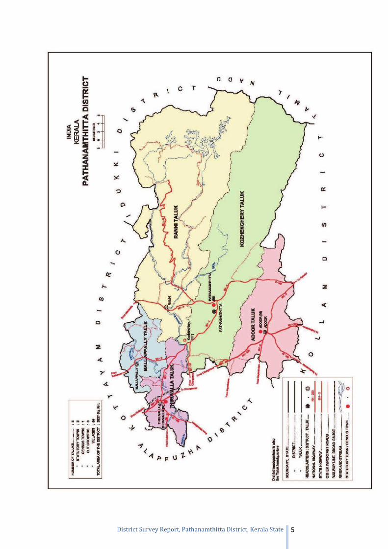
Pathanamthitta is an inland district of Kerala State covering an area of 2731 sq.km. It
is bordered by Kollam district in the south and Alappuzha in the west, Kottayam and
Idukki districts in the north and Tamil Nadu state in the east. It lies between North
latitude 905’ and 9028’ and East longitudes 76030’ and 77017’ falling in parts of
Survey of India degree sheet No.58 C and G.
The district has two revenue divisions namely Thiruvalla and Adoor and consists of five
taluks as Adoor, Kozhencherry, Thiruvalla, Mallapally and Ranni. The five taluks are
having 8 blocks with only three municipalities - Pathanamthitta, Adoor and Thiruvalla.
There are eight blocks viz Parakode, Pandalam, Elanthoor, Konni, Mallappally, Ranni,
Koipuram and Pulikeezhu. Ranni is the biggest block of Thiruvalla division with an
area of 1004.6 sq.km and Konni block of Adoor division constituting an area of 841.26
sq.km. There are fifty four Grama panchayats and sixty eight revenue villages in the
district.
As per census 2011, Pathanamthitta district had a population of 1,195,537 of which
male and female population were 561,620 and 633,917 respectively. There was change
of -3.12% in the population compared to the population as per 2001 census. The density
of population is 453 in 2011 compared to 468 of 2001. There are no major industries in
the district and few small scale industries exists. Agriculture based industries dominate
in the district. The industrial development is more or less restricted to the coastal block
of Pulikeezh.
2 Drainage and Irrigation
The district is drained mainly by two rivers viz. Pamba and Kallada. The major
tributaries of the Pamba River are Achenkovil, Manimala, Kakki, Arudai, Kakkad and
the Kallar that drains through major part of the district. The Kallada River flows
through the southern portion of the district. Both the Pamba and Kallada rivers are
Page 5
District Survey Report, Pathanamthitta District, Kerala State 4
perennial with a drainage density of 0.30 km/sq.km and both are fifth order streams.
These rivers with their tributaries exhibit a trellis pattern of drainage in the eastern
portion of the hills, sub-trellis pattern in the middle and dendritic pattern in the western
part of the district. Almost 57% of the district area is occupied by forest and only about
31% is the net area sown.
Important crops are Coconut, Rubber, Paddy, Banana and Pepper. Though the total
cropped area in the district is 1151 sq km, area sown more than once is restricted to 317
sq km. The irrigation facilities are confined to the valleys in the midland area. Only
2.2% of the district area has irrigation facilities i.e. 6119 hectares and groundwater
irrigation is restricted to 1891 hectares only. A small part (600 hectares) of the
command area of major irrigation project of Pamba falls in the district. The project uses
the tail end water from the Sabirigiri hydroelectric project located in the upstream of
Pamba River. Under minor irrigation schemes, surface water through lift irrigation and
tanks and ground water through wells are utilised.
Page 6
District Survey Report, Pathanamthitta District, Kerala State 5
Page 7
District Survey Report, Pathanamthitta District, Kerala State 6
3 Rainfall and climate
Wet type of climatic condition prevails in the district. The district receives an average
rainfall of 3133.9 mm annually. The major rainfall contribution is from south-west
monsoon season during June to September. Based on 1901-99 data, rainfall during
south-west monsoon contributes nearly 56.8% to the annual rainfall. Followed by this
season, the north-east monsoon season from October to December contributes about
21.7% and the balance 21.5% is received from the rainfall during January to May
months.
The eastern part of the district receives maximum rainfall in comparison with the
western part. The area around Konni receives the highest rainfall and the area around
Adoor receives the lowest.
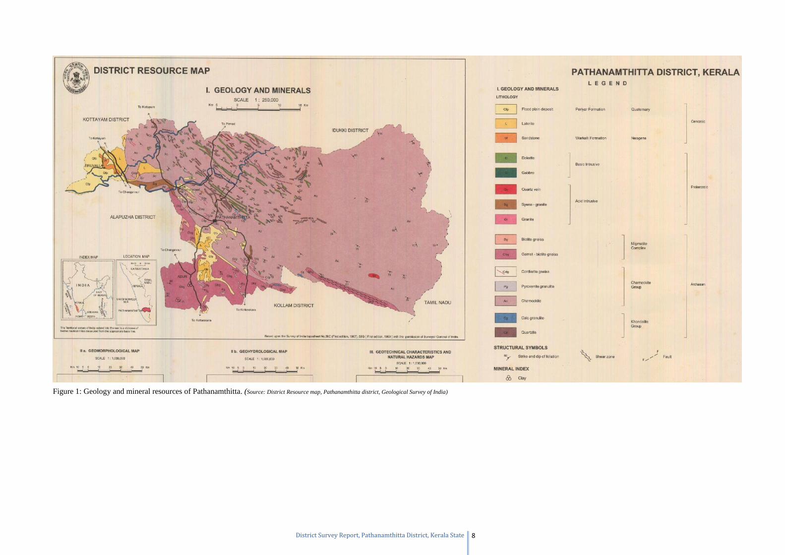
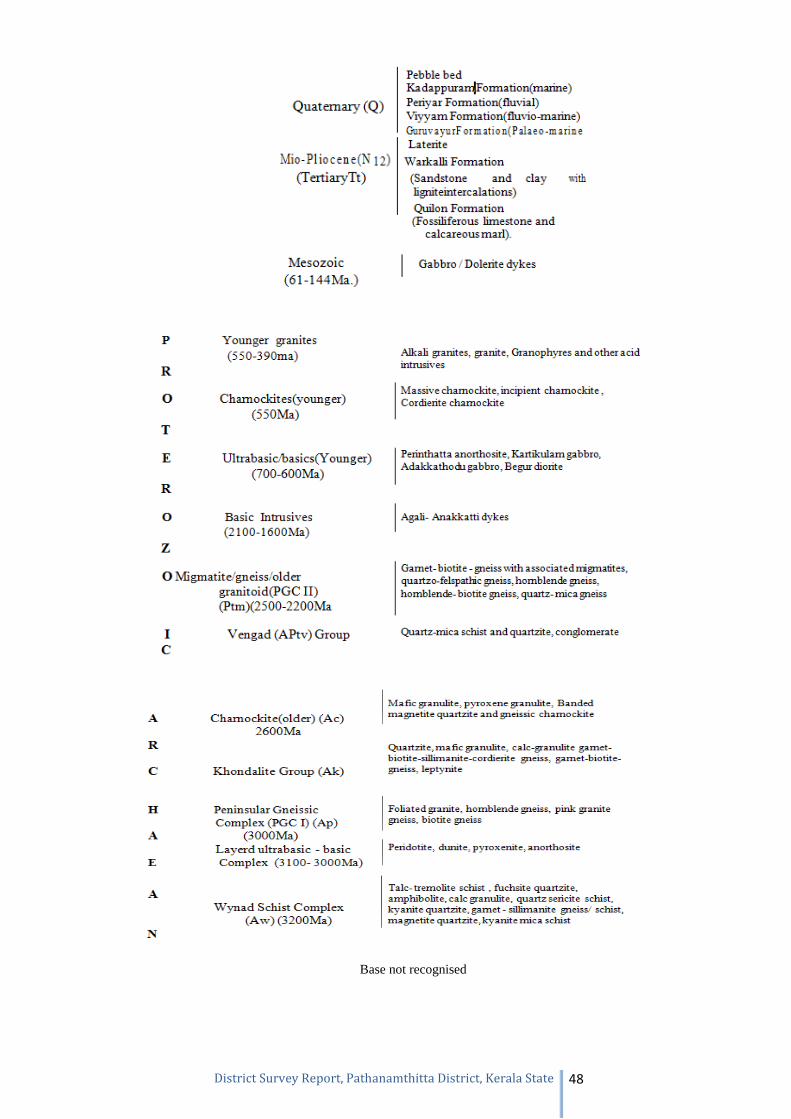
4 Geology
Geologically, the district forms part of the Precambrian metamorphic shield comprising
(i) Charnockite Group, Khondalite Group and Megmatite Complex of Archaean age,
(ii) Acid intrusive of Proterozoic age and (iii) rocks of Cenozoic age (basic intrusive,
Neogene and Quaternary).
Charnockite group is the dominant formation of the area within which occur
concordant, linear and lensoidal bodies of calc granulite and quartzite of Khondalite
Group. The Charnockite Group comprises Charnockite (hypersthenes granite),
pyroxene-granulite and cordierite gneiss. Charnockite is the dominant rock and its
variants are charnockite gneiss, massive charnockite and hypersthenes-diopside gneiss.
The rock is generally dark grey and crudely foliated. Cordierite gneiss occurs as
impersistent bands within charnockite, while pyroxene granulite is seen as restites,
mostly in the west. At places, charnockite is migmatised resulting in the formation of
biotite gneiss, and garnet-biotite gneiss (Migmatite Complex). These rocks are
predominant towards south. The area witnessed a period of igneous activity during the
Proterozoic as evidenced from the granite and syeno-granite (acid intrusive) bodies.
Pegmaite and quartz veins traverse the older rocks parallel to the regional foliation.
Basic igneous activity, probably of Late Mesozoic age, is evidenced from the dolerite
and gabbro dykes cutting across the older rocks. These dykes have a general NW-SE
trend. Warkalli sediment of Neogene age are exposed near Thiruvalla. Along the
western margin, the basement and sedimentary rocks have been lateritised. The
Page 8
District Survey Report, Pathanamthitta District, Kerala State 7
Quaternary sediment mostly of fluvial origin, are the flood plain deposits and the valley
fills (Figure 1). The geology of the district given above may be read with the “Geology
of Kerala” which is given as Annexure 1 for better understanding of geological
succession and stratigraphic sequence.
Page 9
District Survey Report, Pathanamthitta District, Kerala State 8
Figure 1: Geology and mineral resources of Pathanamthitta. (Source: District Resource map, Pathanamthitta district, Geological Survey of India)
Page 10
District Survey Report, Pathanamthitta District, Kerala State 9
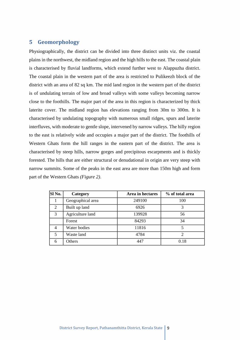
5 Geomorphology
Physiographically, the district can be divided into three distinct units viz. the coastal
plains in the northwest, the midland region and the high hills to the east. The coastal plain
is characterised by fluvial landforms, which extend further west to Alappuzha district.
The coastal plain in the western part of the area is restricted to Pulikeezh block of the
district with an area of 82 sq km. The mid land region in the western part of the district
is of undulating terrain of low and broad valleys with some valleys becoming narrow
close to the foothills. The major part of the area in this region is characterized by thick
laterite cover. The midland region has elevations ranging from 30m to 300m. It is
characterised by undulating topography with numerous small ridges, spurs and laterite
interfluves, with moderate to gentle slope, intervened by narrow valleys. The hilly region
to the east is relatively wide and occupies a major part of the district. The foothills of
Western Ghats form the hill ranges in the eastern part of the district. The area is
characterised by steep hills, narrow gorges and precipitous escarpments and is thickly
forested. The hills that are either structural or denudational in origin are very steep with
narrow summits. Some of the peaks in the east area are more than 150m high and form
part of the Western Ghats (Figure 2).
Sl No. Category Area in hectares % of total area
1 Geographical area 249100 100
2 Built up land 6926 3
3 Agriculture land 139928 56
Forest 84293 34
4 Water bodies 11816 5
5 Waste land 4784 2
6 Others 447 0.18
Page 11
District Survey Report, Pathanamthitta District, Kerala State 10
Figure 2: Geomorphology of Pathanamthitta.
(Source: District Resource map, Pathanamthitta district, Geological Survey of India)
Page 12
District Survey Report, Pathanamthitta District, Kerala State 11
6 Soil types
Based on the morphology, physical and chemical properties, the soils of the district are
classified as Forest Loam, Lateritic, Brown hydromorphic, Riverine alluvium and
Greyish Onattukara soils. The diversity of the parental rock, the climatic conditions and differential weathering has
led to the formation of these different soil types. Forest loam is the product of weathering
of the country rock under forest cover. Forest loamy soil is encountered in the eastern
parts of the district, in major parts of Ranni and Konni blocks. Lateritic soil is the most
widely occurring soil type in the district. This soil is the product of lateralization of the
crystallines and sedimentaries under humid tropical conditions. Brown hydromorphic soil
occurs mostly in valley portions in the midland area of the district. The soil is formed as
a result of transportation and deposition of material from the adjoining hill slopes under
impeded drainage conditions. Riverine alluvium occurs mostly along the banks of rivers
and their tributaries. Greyish Onattukara soil is having very limited occurrence in the
district and is restricted to the western parts of Pulikeezh block.
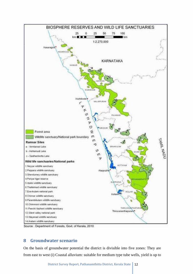
7 Forest
Pathanamthitta district has a reserve forest area of 1,385.27 square kilometres
(534.86 sq mi). This is approximately 50% of the total district area. The forest area can
broadly be classified as evergreen, semi-evergreen and moist deciduous. The forest is the
main source of raw materials for wood based industrial units. Timber is the most
important produce.
Page 13
District Survey Report, Pathanamthitta District, Kerala State 12
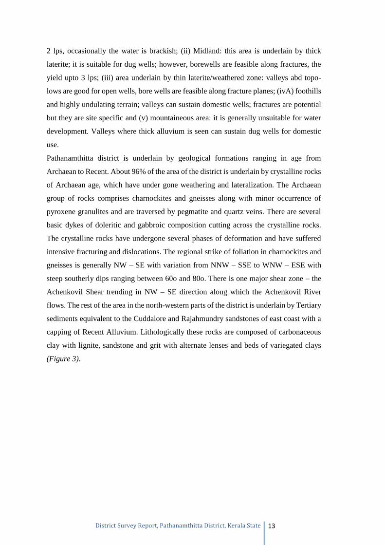
8 Groundwater scenario
On the basis of groundwater potential the district is divisible into five zones: They are
from east to west (i) Coastal alluvium: suitable for medium type tube wells, yield is up to
Page 14
District Survey Report, Pathanamthitta District, Kerala State 13
2 lps, occasionally the water is brackish; (ii) Midland: this area is underlain by thick
laterite; it is suitable for dug wells; however, borewells are feasible along fractures, the
yield upto 3 lps; (iii) area underlain by thin laterite/weathered zone: valleys abd topo-
lows are good for open wells, bore wells are feasible along fracture planes; (ivA) foothills
and highly undulating terrain; valleys can sustain domestic wells; fractures are potential
but they are site specific and (v) mountaineous area: it is generally unsuitable for water
development. Valleys where thick alluvium is seen can sustain dug wells for domestic
use.
Pathanamthitta district is underlain by geological formations ranging in age from
Archaean to Recent. About 96% of the area of the district is underlain by crystalline rocks
of Archaean age, which have under gone weathering and lateralization. The Archaean
group of rocks comprises charnockites and gneisses along with minor occurrence of
pyroxene granulites and are traversed by pegmatite and quartz veins. There are several
basic dykes of doleritic and gabbroic composition cutting across the crystalline rocks.
The crystalline rocks have undergone several phases of deformation and have suffered
intensive fracturing and dislocations. The regional strike of foliation in charnockites and
gneisses is generally NW – SE with variation from NNW – SSE to WNW – ESE with
steep southerly dips ranging between 60o and 80o. There is one major shear zone – the
Achenkovil Shear trending in NW – SE direction along which the Achenkovil River
flows. The rest of the area in the north-western parts of the district is underlain by Tertiary
sediments equivalent to the Cuddalore and Rajahmundry sandstones of east coast with a
capping of Recent Alluvium. Lithologically these rocks are composed of carbonaceous
clay with lignite, sandstone and grit with alternate lenses and beds of variegated clays
(Figure 3).
Page 15
District Survey Report, Pathanamthitta District, Kerala State 14
Figure 3: Geohydrology of Pathanamthitta.
(Source: District Resource map, Pathanamthitta district,Geological Survey of India)
Page 16
District Survey Report, Pathanamthitta District, Kerala State 15
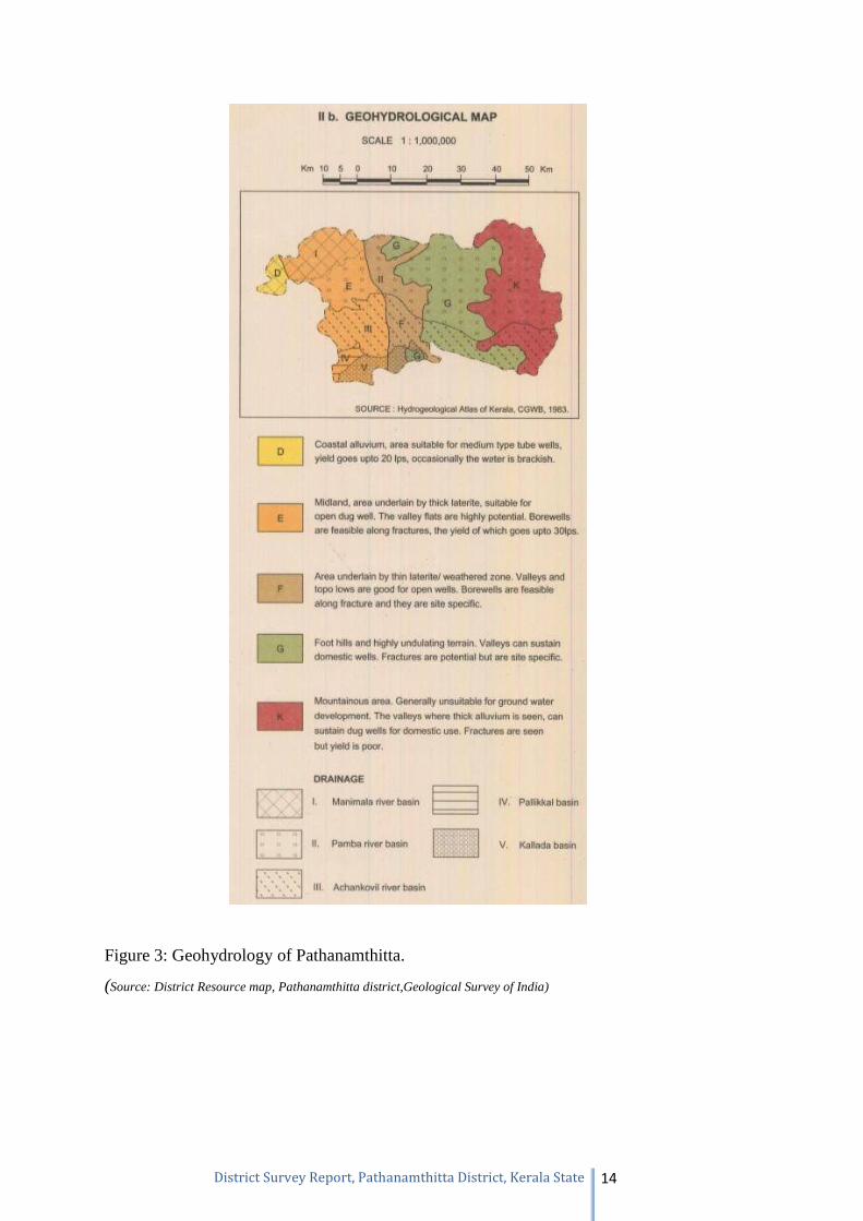
9 Natural hazards
The area comes under zone III and indicates moderate seismicity (Figure 4).
Figure 4: Geotechnical characteristics and natural hazards map of Pathanamthitta.
(Source: District Resource map, Pathanamthitta district, Geological Survey of India)
Page 17
District Survey Report, Pathanamthitta District, Kerala State 16
10 Mineral Resources
10.1 Minor Minerals
10.1.1 Ordinary Earth
Ordinary earth is the common name used for the soils. Soil is made up of three main
components – minerals that come from rocks below or nearby, organic matter which is the
remains of plants and animals that use the soil, and the living organisms that reside in the
soil. The proportion of each of these is important in determining the type of soil that is
present. But other factors such as climate, vegetation, time, the surrounding terrain, and even
human activities (eg. farming, grazing, gardening, landscaping, etc.), are also important in
influencing how soil is formed and the types of soil that occur in a particular landscape. The
formation of soils can be seen as a combination of the products of weathering, structural
development of the soil, differentiation of that structure into horizons or layers, and lastly,
of its movement or translocation. In fact, there are many ways in which soil may be
transported away from the location where it was first formed. Soils represent one of the most
complex and dynamic natural systems and are one of the three major natural resources, other
than air and water. Knowledge of their chemical, physical and biological properties is a
prerequisite both for sustaining the productivity of the land, e.g. agriculture, and for
conservation purposes. Soil is an integral part of a terrestrial ecosystem and fulfills numerous
functions including the capacity to generate biomass and the filtering or buffering activities
between the atmosphere and the groundwater in the biosphere. Soils have many important
functions. Perhaps the best appreciated is the function to support the growth of agricultural
and horticultural crops. Soil is the mainstay of agriculture and horticulture, forming as it
does the medium in which growth and ultimately the yield of food producing crops occurs.
Farmers and gardeners have worked with their soils over many centuries to produce
increasing amounts of food to keep pace with the needs of a burgeoning world population.
The soil's natural cycles go a long way in ensuring that the soil can provide an adequate
physical, chemical and biological medium for crop growth. As well as being essential to
agriculture, horticulture, forestry and natural and semi-natural systems, soil also plays an
important role for our fauna. The soil itself contains millions of organisms, the exact nature
and role of which we are still trying to determine. Undoubtedly, the soil flora and fauna play
a vital role in cycles which are fundamental to the ability of the soil to support natural and
semi-natural vegetation without additions of fertilizer and other support mechanisms. They
Page 18
District Survey Report, Pathanamthitta District, Kerala State 17
breakdown plant debris, take in components from the atmosphere, aerate the soil together
with many other functions that make the soil such an important medium.
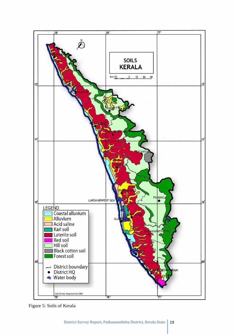
Classification of soils (ordinary earth) commonly found in the district
The topo-lithosequence along with variation in rainfall, temperature and alternate wet and
dry conditions particularly from the western coast to high ranges in the east and swift flowing
rivers lead to the development of different types of natural vegetation and soil. The soils can
be broadly grouped into coastal alluvium, mixed alluvium, acid saline, kari, laterite, red, hill,
black cotton and forest soils. Soil map given below may be referred to find out its
occurrences.
Mixed Alluvium
These soils are developed from fluvial sediments of marine, lacustrine and riverine
sediments or its combinations. They occur below 20m MSL in the lowland plains, basins,
valleys and along the banks of major rivers. The mixed alluvium is mainly noticed close to
coastal alluvium, Kuttanad and adjacent area and kole lands of Thrissur district. The soils
are frequently flooded and submerged. The soils of depressions and broad valleys are subject
to occasional flooding and stagnation. The ground water table of these soils is generally high
and it reaches above the surface during rainy season. A wide variation in texture is noticed
in these soils. Sandy clay loam to clay is the predominant texture. Sandy loam soils are also
met with. Light grey to very dark brown is the common colour of the soil. Paddy, other
annuals and seasonal crops like banana, tapioca and vegetables are grown here.
Laterite soil
Laterite and laterite soil are the weathering products of rock in which several course of
weathering and mineral transformations take place. This involves removal of bases and
substantial loss of combined silica of primary minerals. In laterite and laterite soils, over
acidic rocks, induration and zonation are more pronounced. This induration is greater if the
iron content is higher. These soils mainly occur in the midlands and part of lowlands at an
elevation of 10 to 100m above MSL as a strip between the coastal belt and hilly mid-upland.
The area comprises of mounds and low hills with gentle to steep slopes. Laterite soils are
generally suitable for most of the dry land crops. It is mainly cultivated with coconut,
arecanut, banana, tapioca, vegetables, yams, pepper, pineapple, fruit trees etc. The
percentage of gravel content in the soil and reduced soil depth limits the choice of crops. In
laterite outcropped area with shallow soils, only cashew can be grown with vegetables.
Page 19
District Survey Report, Pathanamthitta District, Kerala State 18
Hill Soil
The hill soils mostly occur above an elevation of 80m MSL. The area is hilly and has highly
dissected denudational hills, elongated ridges, rocky cliffs and narrow valleys. The general
slope range is above 10%. The texture of these soils generally ranges from loam to clay loam
with average gravel content of 10 to 50%. In addition, stones and boulders are noticed in the
subsoil. These soils have reddish brown to yellowish red/strong brown colour. Generally,
increase in clay content is noticed down the profile. The depth of the soil varies considerably
from 60 to 200 cm depending on erodability of soil and past erosion. These soils are mostly
friable and subject to heavy soil erosion. The area is suitable for all dry land crops like rubber,
coconut, arecanut and fruit trees based on the topography. Crops such as banana, pepper,
pineapple, vegetables can be grown in foot slopes.
Forest Soil
These soils are developed from crystalline rocks of Archaean age under forest cover. They
occur along the eastern part of the State, generally above an elevation of 300m above MSL.
The area is hilly and mountainous with steep slopes, escarpments, elongated rocky summits
and narrow ‘V’ shaped valleys. The depth of the soil varies considerably depending on
erosion and vegetative cover. The soils are generally immature due to slow weathering
process. Rocky outcrops and stones are noticed on the surface. Gneissic boulders under
different stages of weathering are noticed in the subsoil. The texture of the soil ranges from
sandy clay loam to clay with reddish brown to very dark brown colour. Forest trees, shrubs
and grasses are grown here.
Page 20
District Survey Report, Pathanamthitta District, Kerala State 19
Figure 5: Soils of Kerala
Page 21
District Survey Report, Pathanamthitta District, Kerala State 20
Mining of ordinary earth
Usually ordinary earth is mined for levelling of ground for construction of buildings. Since
ordinary earth is very important to mankind, it is not wise to mine ordinary earth for filling
purposes alone. However, for the construction of roads and other infrastructure, ordinary earth
as mined after obtaining quarrying permit from the Department of Mining and Geology.
Mining and transporting ordinary earth/soil without the permission of Department of Mining
and Geology is an offence. Department issues pass for transport of ordinary earth. Dealer’s
license is not issued for ordinary earth as it is not considered as a mineral mined for
commercial purposes.
10.1.2 Ordinary Clay (tile/brick clay)
Clays and clay minerals occur under a fairly limited range of geological conditions and are
produced by weathering of silicate minerals containing calcium, magnesium, sodium, or
potassium reacting with carbonic acid, carbonates, and bicarbonates. These soluble products
are removed by ground water, while the remaining elements, aluminium, silicon, and oxygen
combine with water to produce stable clay minerals. The environment of formation include
soil horizons, continental and marine sediments, geothermal fields, volcanic deposits, and
weathering rock formations. Extensive alteration of rocks to clay minerals can produce
relatively pure clay deposits that are of economic interest. Clay formed at the site of the parent
rock is known as primary or residual clay; the one carried away or transported and deposited
elsewhere is known as secondary clay. For obvious reasons, the former is purer with less
impurity (5%–15%), while the latter may contain mica, quartz, and iron oxide as impurities.
Geological factors such as conditions at the time of deposition and post-depositional changes
have an important influence on the properties of sediment.
Buildings and utensils made of clay date back to the earliest periods of man's civilized
development, and the use of clay is intimately associated with his history. Tile and brick kilns
are closely associated with Kerala’s culture and traditional architecture, which is continued in
modern buildings as well.
In Kerala, tile/brick clay occurs in the wetlands/paddy fields in the lowlands and midlands.
The clay extracted is used for a variety of purposes such as manufacture of roofing, flooring,
and decorative tiles, wire cut (mechanically made) and ordinary bricks (manually made), and
pottery wares. Studies carried out in clay mining areas of Kerala have proved that
unprecedented increase in the development needs of the state and the subsequent increase in
the resource extraction scenarios, especially that of clay mining, have led to rapid degradation
Page 22
District Survey Report, Pathanamthitta District, Kerala State 21
of the wetlands (paddy fields), which is significantly reflected in the declining agricultural
productivity of the state. Mining of clays several meters below the prescribed levels, water
draining from the unaffected paddy lands into the adjacent mine pits, and subsequent pumping
of water for further mining impose severe problems on the hydrological regime, lowering the
water table and creating severe water shortage problems in the mining areas. The additional
expenditure incurred to meet the freshwater requirements of the people living in areas adjacent
to mining sites is increasing year after year, which undermines the short-term economic
benefits of resource extraction.
Tile and brick clay mining and its processing provide employment opportunities to a
considerable section of the people in the midland and lowland areas of Kerala. Adding to this,
thousands of labourers in the construction industry also indirectly depend on the products
manufactured from these clays. Under these circumstances and also with respect to the
demand incurred, complete restriction of extraction activities does not prove to be viable.
In the study report published by National Center for Earth Science Studies on the impact of
clay mining, following recommendations were given with respect to tile/brick clay mining:
“It is of imminent importance to regulate random mining from the paddy fields/wetlands of
Kerala by allowing only location-specific resource extraction under well-conceived
guidelines. It is also crucial to limit the extraction of tile and brick clays to meet indigenous
and local demand only. This is to save the prime agricultural land and also to increase the rice
production in the area. The depth of mining should be demarcated so as to regulate mining
with respect to the water table condition in the summer season. Also, adequate measures are
to be taken to regenerate the natural ground water table using the stored water in the clay mine
pits for irrigating the agricultural crops of the hinterland areas. This will enhance the net
agricultural productivity of the area in addition to saturating the aquifer systems in the
hinterlands. Awareness creation among the public about the adversities of clay mining and as
well as the economic benefits of using clay bricks for construction purposes will serve in the
protection of our wetlands/paddy fields. Recycling of building materials should also be
considered in order to reduce mining of tile and brick clays. The abandoned clay mine areas
left behind as fallow lands or water logged areas can be used for productive purposes such as
fish farm ponds or irrigation ponds that promise some utility to the society. Also, suitable
guidelines should be framed to streamline the tile and brick clay mining activities of the state
on an eco-friendly basis.”
The Kerala Conservation of Paddy Land and Wetland Act, 2008 and Rules made thereunder
which was enacted for conservation of paddy land and wetlands of Kerala imposes restrictions
Page 23
District Survey Report, Pathanamthitta District, Kerala State 22
in mining of tile/brick clays in such areas. The said Act and Rules are implemented by
Revenue Department. In addition, Government have setup District Expert Committee to
monitor and control the mining activities of ordinary clay. In Kerala Minor Mineral
Concession Rules 2015, it is mandated that No Objection Certificate from the District
Collector concerned, based on the recommendation of the District Expert Committee
constituted by the Government in this regard, is to be produced by the applicant in the case of
application for extraction of ordinary clay. In addition, Bank guarantee from any Nationalized
or Scheduled Bank at the rate of Rs. 300/- (Rupees three hundred only) per cubic metre for
the purpose of reclamation of pits that will be formed after quarrying in the area permitted, in
respect of application for extraction of ordinary clay. Based on the request of the entrepreneurs
working in tile/brick clay based industry, Government have instructed the Department of
Mining and Geology to carry out survey to identify the mineable tile/brick clay deposits of
Kerala and the work in this respect is progressing. Clay occurs south of Adoor.
10.1.3 Ordinary Sand
In Kerala Minor Mineral Concession Rules, 2015, the ordinary sand is defined as sand used
for non-industrial purpose. This includes both river sand and sand excavated from inland areas
like palaeo-channels. Since a separate Act has been enacted by Government of Kerala namely,
The Kerala Protection of River Banks and Regulation of Removal of Sand Act, 2001 (hereafter
referred to as Sand Act, 2001) and since the mining of river sand is controlled by Revenue
Department by virtue of the powers conferred by the said Act and the Rules made thereunder,
the Department of Mining and Geology now regulates the mining of sand which do not comes
under the purview of Sand Act, 2001.
The ordinary sand (other than river sand) occurs in the palaeo-channels. The word palaeo-
channel is formed from the words “palaeo” or “old,” and channel; i.e., a palaeo-channel is an
old channel. Palaeo-channels are deposits of unconsolidated sediments or semi-consolidated
sedimentary rocks deposited in ancient, currently inactive river and stream channel systems.
These are typical riverine geomorphic features in a location representing drainage streams,
rivers, rivulets which were flowing either ephemeral or perennial during the past time and
now stands either buried or lost or shifted due to tectonic, geomorphologic, anthropogenic
process/activities, as well as climatic changes. When a channel ceases to be part of an active
river system, it becomes a palaeo-channel. In order to tap the ordinary sand occurring in
palaeo-channels, the Department entrusted the study of identification of palaeo-channels in
major river basins of Kerala to Geological Survey of India (GSI). GSI resorted to remote
Page 24
District Survey Report, Pathanamthitta District, Kerala State 23
sensing studies using satellite imageries and delineated some of the palaeo-channels.
However, since such deposits falls in paddy land/wetlands of Kerala, it is difficult to extract
such sand on account of restrictions imposed by various Acts and Rules.
The Kerala Conservation of Paddy Land and Wetland Act, 2008 and Rules made thereunder
which was enacted for conservation of paddy land and wetlands of Kerala imposes restrictions
in mining of ordinary sands occurring in wetlands and paddy fields. The said Act and Rules
are implemented by Revenue Department. In addition, Government have setup District Expert
Committee to monitor and control the mining activities of ordinary sand. In Kerala Minor
Mineral Concession Rules 2015, it is mandated that No Objection Certificate from the District
Collector concerned, based on the recommendation of the District Expert Committee
constituted by the Government in this regard, is to be produced by the applicant in the case of
application for extraction of ordinary sand. In addition, Bank guarantee from any Nationalized
or Scheduled Bank at the rate of Rs. 300 (Rupees three hundred only) per cubic metre for the
purpose of reclamation of pits that will be formed after quarrying in the area permitted, in
respect of application for extraction of ordinary sand.
The mining of ordinary sand from palaeo-channels also case some environmental concerns.
Since sand is a good aquifer, the mining of aquifer system poses threat to ground water
availability in surrounding areas. However in certain cases, the mining of such sand from
paddy lands increase the productivity of paddy as excess sand in the paddy lands are not good
for paddy.
In Kerala, due to shortage of river sand and ordinary sand occurring in palaeo-channels, the
construction industry now uses manufactured sand obtained by crushing of crystalline rocks.
It may be noted that since the Revenue Department is taking care of all types of mining
activities related to river sand and since sand auditing and other studies are carried out
under the aegis of the Revenue Department, this report shall not be used for the purpose
of obtaining prior environmental clearance for mining of river sand.
10.1.4 Laterite
Laterite is a soil and rock type rich in iron and aluminium, and is commonly considered to
have formed in hot and wet tropical areas. Nearly all laterites are of rusty-red coloration,
because of high iron oxide content. They develop by intensive and long-lasting weathering of
the underlying parent rock. Tropical weathering is a prolonged process of chemical weathering
which produces a wide variety in the thickness, grade, chemistry and ore mineralogy of the
Page 25
District Survey Report, Pathanamthitta District, Kerala State 24
resulting soils. The majority of the land area containing laterites is between the tropics of
Cancer and Capricorn.
Angadipuram Laterite is a National Geological Monument identified in Angadipuram town in
Malappuram district. The special significance of Angadipuram to laterites is that it was here
that Dr. Francis Buchanan-Hamilton, a professional surgeon, gave the first account of this
rock type, in his report of 1807, as "indurated clay", ideally suited for building construction.
This formation falls outside the general classification of rocks namely, the igneous,
metamorphic, or sedimentary rocks but is an exclusively "sedimentary residual product". It
has a generally pitted and porous appearance. The name laterite was first coined in India, by
Buchanan and its etymology is traced to the Latin word "letritis" that means bricks. This
exceptional formation is found above parent rock types of various composition namely,
charnockite, leptynite, anorthosite and gabbro in Kerala. The laterite profiles in different types
of rocks vary depending on the composition of parent rock. For example in Charnockites, the
thickness of the profile ranges from 2 m to 10 m with humus zone on the top with thin pebbly
zone (with ferruginous pellets in clayey matrix), underlain by vermicular laterite with tubular
cavities of various shapes and size filled with kaolinitic clay. This is followed by thin layer of
lithomarge. Further below completely weathered, partly weathered or fresh parent rock occur.
In some places one can see hard duricrust at the top.
The mineralogical study of laterites reveals that all the silicate minerals have been transformed
to a mixture of goethite, hematite and kaolinite in laterite samples developed over charnockite.
Further studies revealed that pyroxenes have been altered to goethite while feldspars gave rise
to kaolinite. Quartz is cracked, eroded and disintegrated. Monazite and Zircons are found as
accessory minerals.
Laterite and bauxite show a tendency to occur together. Aluminous laterites and ferruginous
bauxites are quite common. The most common impurity in both is silica. Laterite gradually
passes into bauxite with decrease in iron oxide and increase in aluminium oxide. The laterite
deposits may be described on the basis of the dominant extractable minerals in it: (i) aluminous
laterite (bauxite), (ii) ferruginous laterite (iron ore), (iii) manganiferous laterite (manganese
ore), (iv) nickeliferous laterite (nickel ore) and (v) chromiferous laterite (chrome ore). Laterite
with Fe2O3:Al2O3ratio more than one, and SiO2:Fe2O3 ratio less than 1.33 is termed as
ferruginous laterite, while that having Fe2O3:Al2O3 ratio less than one and SiO2:Al2O3 ratio
less than 1.33 is termed as aluminous laterite. Laterite can be considered as poly-metallic ore
as it is not only the essential repository for aluminium, but also a source of iron, manganese,
nickel and chromium. Furthermore, it is the home for several trace elements like gallium and
Page 26
District Survey Report, Pathanamthitta District, Kerala State 25
vanadium which can be extracted as by-products.
In Kerala laterites are extracted as building stones which are used for construction of building.
Laterite as a building stone possesses one advantage that it is soft when quarried and can be
easily cut and dressed into blocks and bricks which on exposure to air become hard. In
addition, laterite (aluminous laterite) is extracted for industrial purposes (for eg. Cement
industry). In addition to aluminous laterite, bauxites are also mined in Kerala. Hence, while
granting mineral concession for laterite it is necessary to carry out the chemical analysis to
establish whether the mineral is bauxite or aluminous laterite.
10.1.5 Granite Dimension Stone and Granite (building stone)
For administrative purpose the hard crystalline rocks which do not have any economic
minerals are classified as granite dimension stones and granite (building stones). The
definition given in the Kerala Minor Mineral Concession Rules 2015 is as follows:-
‘Granite dimension stones include all types of granites, dolerite, charnockite, leptynite and
other crystalline rocks of Acid, Intermediate, basic and ultra basic groups of igneous and
metamorphic origin which are suitable for cutting to pre-determined sizes, polishing, carving
and amenable for making value-added products in decorative monumental and ornamental
fields of industry as a high-value item. Granite (building stone) include all those group of
rocks specified above which are not suitable for using as dimension stones as specified therein,
but can be used as ordinary building stones, road metal, rubble and ballasts after breaking into
irregular pieces by blasting or otherwise as low value item. The Rules insists that the rocks
having the quality of granite dimension stone shall not be quarried for granite building stone
as these two types of rocks have different values/royalties’.
The major granite dimension stone occurrence in the district forms part of Charnockite-
Khondalite belt and has colour ranging from pale green with mottled red, bluish green with
cordierite, deep dark green, greyish white. Charnockite is largely used as a building stone.
All Archaean and Proterozoic rocks of Kerala (refer section on Geology of Kerala) which are
not listed above as granite dimension stone falls under the category of granite (building stone)
and are found below ordinary earth/laterites/and other sedimentary rocks. In some cases such
rocks are exposed as hillocks without any overburden.
Page 27
District Survey Report, Pathanamthitta District, Kerala State 26
11 Details of minor mineral concessions and revenue
collection
Permission for mining will be granted on case to case basis on ascertaining the availability at
the site and only if conditions stipulated in the KMMC Rules 2015 are satisfied (The reader
may refer the KMMC Rules 2015 available in the website www.dmg.kerala.gov.in for more
details in this regard). The concession will be granted only if other statutory licenses like
Environmental Clearance, Explosive Licence, consent to operate issued by State Pollution
Control Board, NOC issued by Revenue Department (as the case may be), Dangerous and
Offensive Trade Licence issued by Local Self Government Institutions, NOC related to
Coastal Regulation Zone (as the case may be), NOC issued by Forest (as the case may be) etc.
The mineral concession will not be granted in the ecologically sensitive areas, ecological
fragile zones etc. The details of valid minor mineral concessions issued by the Department are
given in the table below:-
Page 28
District Survey Report, Pathanamthitta District, Kerala State 27
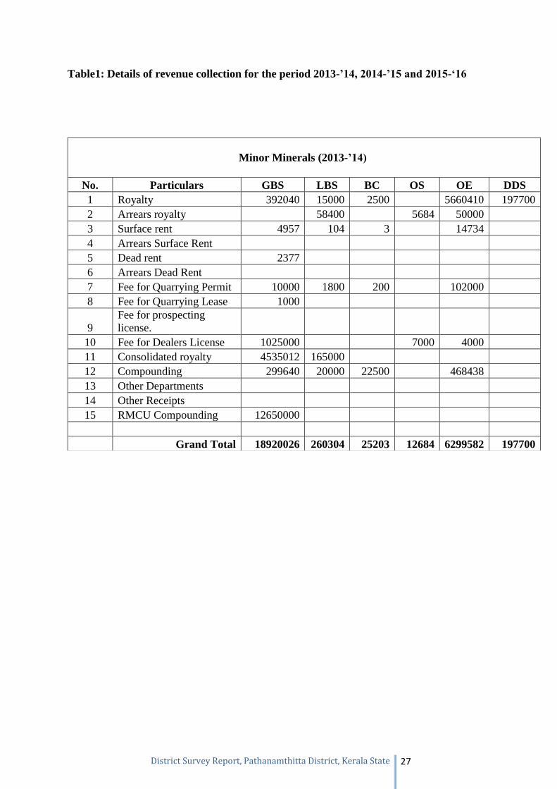
Table1: Details of revenue collection for the period 2013-’14, 2014-’15 and 2015-‘16
Minor Minerals (2013-’14)
No. Particulars GBS LBS BC OS OE DDS 1 Royalty 392040 15000 2500 5660410 197700 2 Arrears royalty 58400 5684 50000 3 Surface rent 4957 104 3 14734 4 Arrears Surface Rent 5 Dead rent 2377 6 Arrears Dead Rent 7 Fee for Quarrying Permit 10000 1800 200 102000 8 Fee for Quarrying Lease 1000
9 Fee for prospecting license.
10 Fee for Dealers License 1025000 7000 4000 11 Consolidated royalty 4535012 165000 12 Compounding 299640 20000 22500 468438 13 Other Departments 14 Other Receipts 15 RMCU Compounding 12650000
Grand Total 18920026 260304 25203 12684 6299582 197700
Page 29
District Survey Report, Pathanamthitta District, Kerala State 28
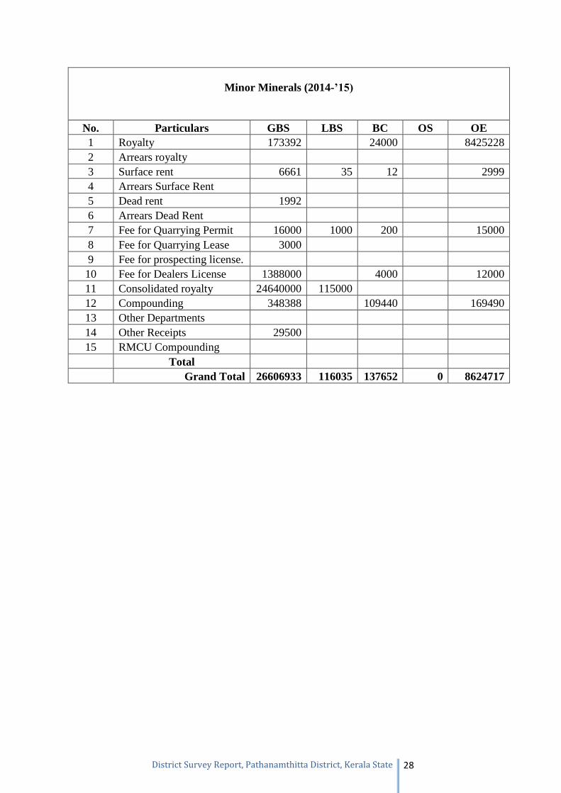
Minor Minerals (2014-’15)
No. Particulars GBS LBS BC OS OE 1 Royalty 173392 24000 8425228 2 Arrears royalty 3 Surface rent 6661 35 12 2999 4 Arrears Surface Rent 5 Dead rent 1992 6 Arrears Dead Rent 7 Fee for Quarrying Permit 16000 1000 200 15000 8 Fee for Quarrying Lease 3000 9 Fee for prospecting license. 10 Fee for Dealers License 1388000 4000 12000 11 Consolidated royalty 24640000 115000 12 Compounding 348388 109440 169490 13 Other Departments 14 Other Receipts 29500 15 RMCU Compounding
Total Grand Total 26606933 116035 137652 0 8624717
Page 30
District Survey Report, Pathanamthitta District, Kerala State 29
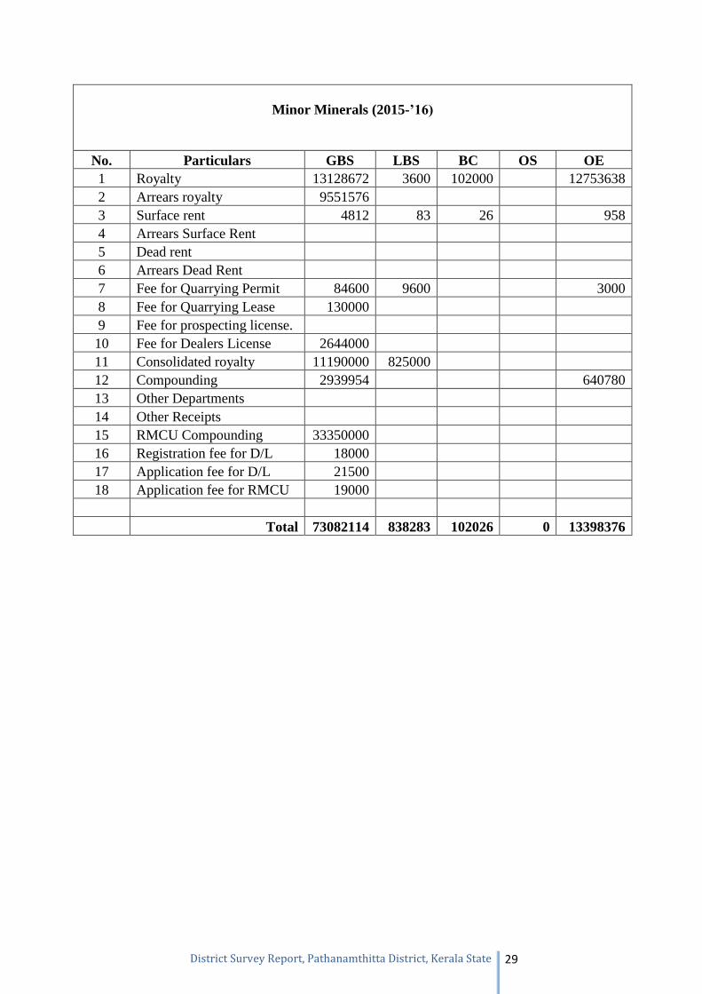
Minor Minerals (2015-’16)
No. Particulars GBS LBS BC OS OE 1 Royalty 13128672 3600 102000 12753638 2 Arrears royalty 9551576 3 Surface rent 4812 83 26 958 4 Arrears Surface Rent 5 Dead rent 6 Arrears Dead Rent 7 Fee for Quarrying Permit 84600 9600 3000 8 Fee for Quarrying Lease 130000 9 Fee for prospecting license. 10 Fee for Dealers License 2644000 11 Consolidated royalty 11190000 825000 12 Compounding 2939954 640780 13 Other Departments 14 Other Receipts 15 RMCU Compounding 33350000 16 Registration fee for D/L 18000 17 Application fee for D/L 21500 18 Application fee for RMCU 19000
Total 73082114 838283 102026 0 13398376
Page 31
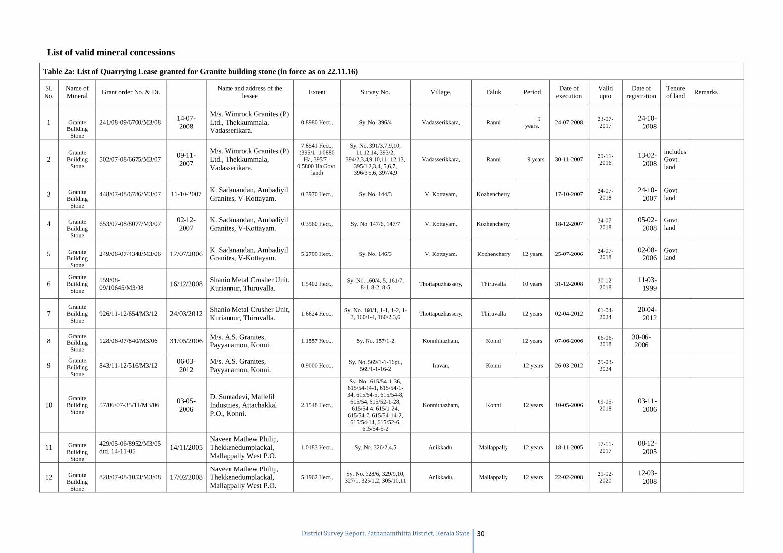
District Survey Report, Pathanamthitta District, Kerala State 30
List of valid mineral concessions
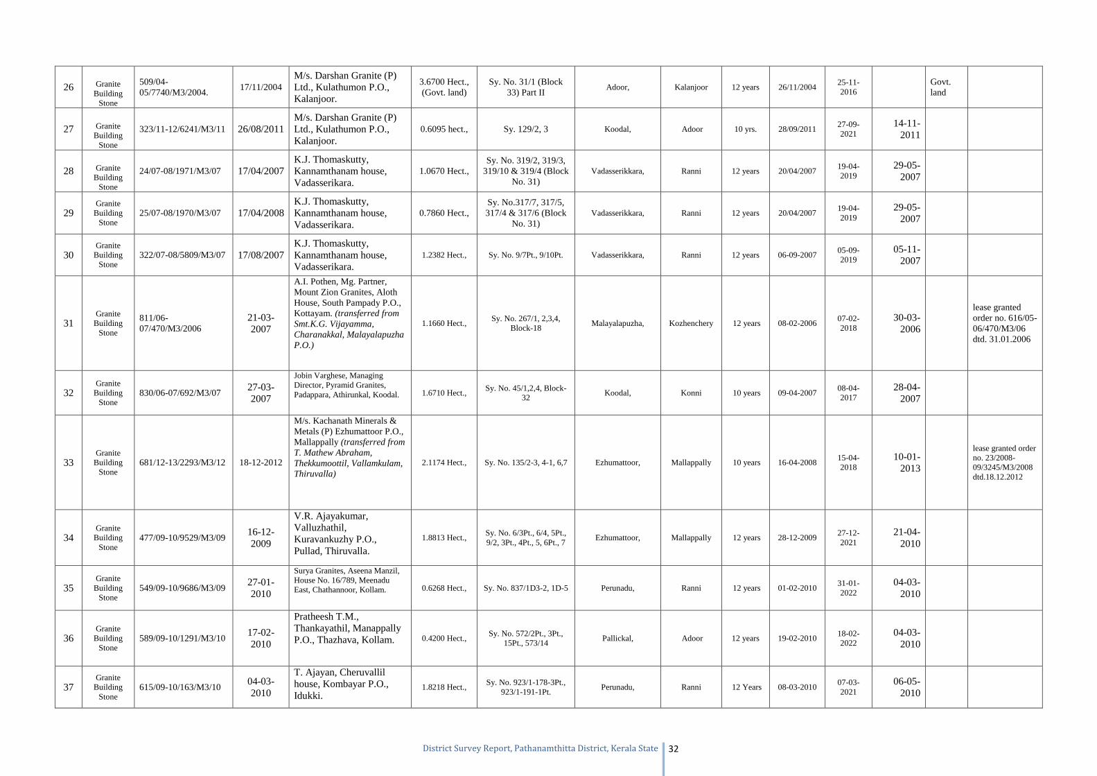
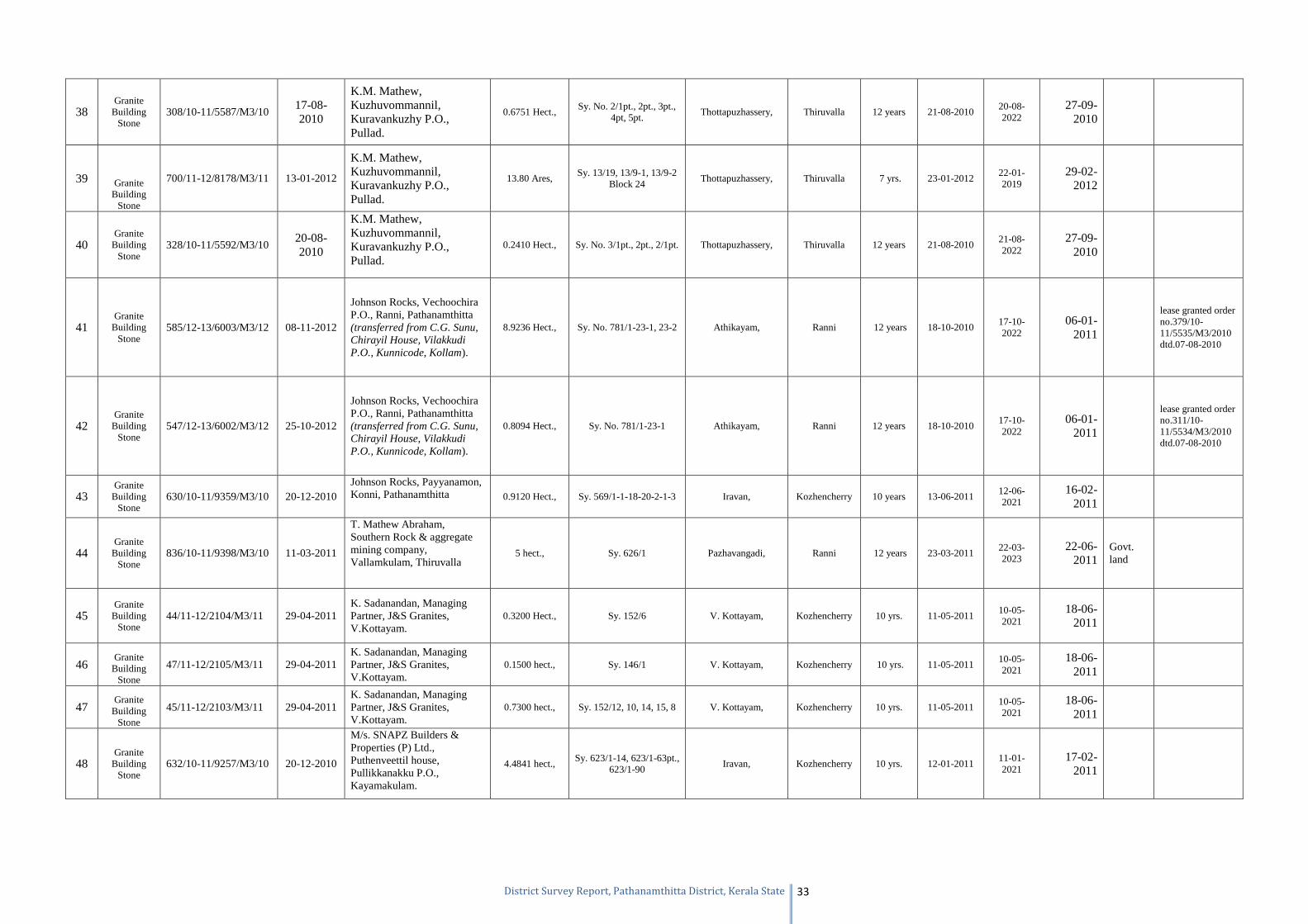
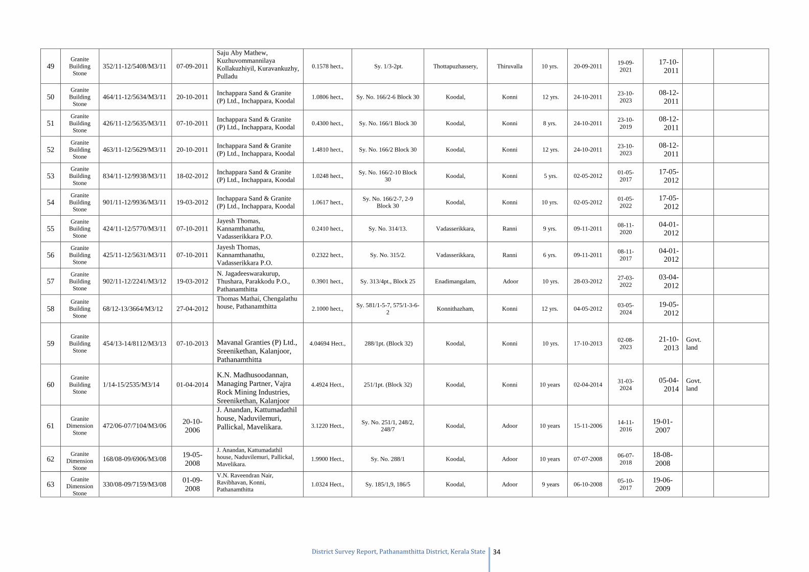
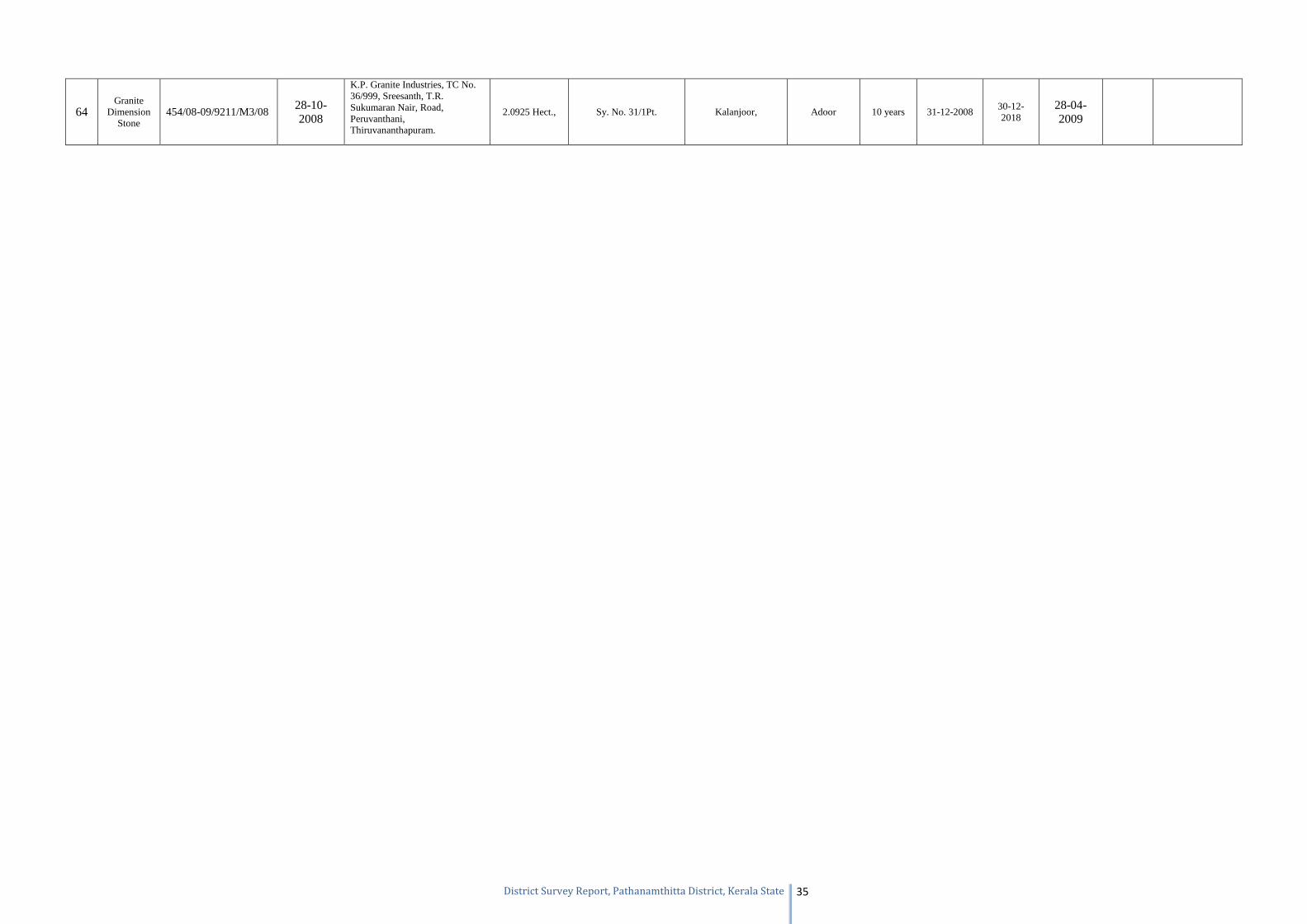
Table 2a: List of Quarrying Lease granted for Granite building stone (in force as on 22.11.16)
Sl. No.
Name of Mineral
Grant order No. & Dt. Name and address of the
lessee Extent Survey No. Village, Taluk Period
Date of execution
Valid upto
Date of registration
Tenure of land
Remarks
1 Granite Building
Stone
241/08-09/6700/M3/08 14-07-2008
M/s. Wimrock Granites (P) Ltd., Thekkummala, Vadasserikara.
0.8980 Hect., Sy. No. 396/4 Vadasserikkara, Ranni 9 years.
24-07-2008 23-07-2017
24-10-2008
2 Granite
Building Stone
502/07-08/6675/M3/07 09-11-2007
M/s. Wimrock Granites (P) Ltd., Thekkummala, Vadasserikara.
7.8541 Hect., (395/1 -1.0880
Ha, 395/7 -0.5800 Ha Govt.
land)
Sy. No. 391/3,7,9,10, 11,12,14, 393/2,
394/2,3,4,9,10,11, 12,13, 395/1,2,3,4, 5,6,7, 396/3,5,6, 397/4,9
Vadasserikkara, Ranni 9 years 30-11-2007 29-11-2016
13-02-2008
includes Govt. land
3 Granite Building
Stone
448/07-08/6786/M3/07 11-10-2007 K. Sadanandan, Ambadiyil Granites, V-Kottayam.
0.3970 Hect., Sy. No. 144/3 V. Kottayam, Kozhencherry 17-10-2007 24-07-2018
24-10-2007
Govt. land
4 Granite Building
Stone
653/07-08/8077/M3/07 02-12-2007
K. Sadanandan, Ambadiyil Granites, V-Kottayam.
0.3560 Hect., Sy. No. 147/6, 147/7 V. Kottayam, Kozhencherry 18-12-2007 24-07-2018
05-02-2008
Govt. land
5 Granite Building
Stone
249/06-07/4348/M3/06 17/07/2006 K. Sadanandan, Ambadiyil Granites, V-Kottayam.
5.2700 Hect., Sy. No. 146/3 V. Kottayam, Kozhencherry 12 years. 25-07-2006 24-07-2018
02-08-2006
Govt. land
6 Granite
Building Stone
559/08-09/10645/M3/08 16/12/2008
Shanio Metal Crusher Unit, Kuriannur, Thiruvalla.
1.5402 Hect., Sy. No. 160/4, 5, 161/7,
8-1, 8-2, 8-5 Thottapuzhassery, Thiruvalla 10 years 31-12-2008
30-12-2018
11-03-1999
7 Granite
Building Stone
926/11-12/654/M3/12 24/03/2012 Shanio Metal Crusher Unit, Kuriannur, Thiruvalla.
1.6624 Hect., Sy. No. 160/1, 1-1, 1-2, 1-
3, 160/1-4, 160/2,3,6 Thottapuzhassery, Thiruvalla 12 years 02-04-2012
01-04-2024
20-04-2012
8 Granite
Building Stone
128/06-07/840/M3/06 31/05/2006 M/s. A.S. Granites, Payyanamon, Konni.
1.1557 Hect., Sy. No. 157/1-2 Konnithazham, Konni 12 years 07-06-2006 06-06-2018
30-06-2006
9 Granite
Building Stone
843/11-12/516/M3/12 06-03-2012
M/s. A.S. Granites, Payyanamon, Konni.
0.9000 Hect., Sy. No. 569/1-1-16pt.,
569/1-1-16-2 Iravan, Konni 12 years 26-03-2012
25-03-2024
10 Granite
Building Stone
57/06/07-35/11/M3/06 03-05-2006
D. Sumadevi, Mallelil Industries, Attachakkal P.O., Konni.
2.1548 Hect.,
Sy. No. 615/54-1-36, 615/54-14-1, 615/54-1-34, 615/54-5, 615/54-8,
615/54, 615/52-1-28, 615/54-4, 615/1-24,
615/54-7, 615/54-14-2, 615/54-14, 615/52-6,
615/54-5-2
Konnithazham, Konni 12 years 10-05-2006 09-05-2018
03-11-2006
11 Granite Building
Stone
429/05-06/8952/M3/05 dtd. 14-11-05 14/11/2005
Naveen Mathew Philip, Thekkenedumplackal, Mallappally West P.O.
1.0183 Hect., Sy. No. 326/2,4,5 Anikkadu, Mallappally 12 years 18-11-2005 17-11-2017
08-12-2005
12 Granite Building
Stone
828/07-08/1053/M3/08 17/02/2008 Naveen Mathew Philip, Thekkenedumplackal, Mallappally West P.O.
5.1962 Hect., Sy. No. 328/6, 329/9,10,
327/1, 325/1,2, 305/10,11 Anikkadu, Mallappally 12 years 22-02-2008
21-02-2020
12-03-2008
Page 32
District Survey Report, Pathanamthitta District, Kerala State 31
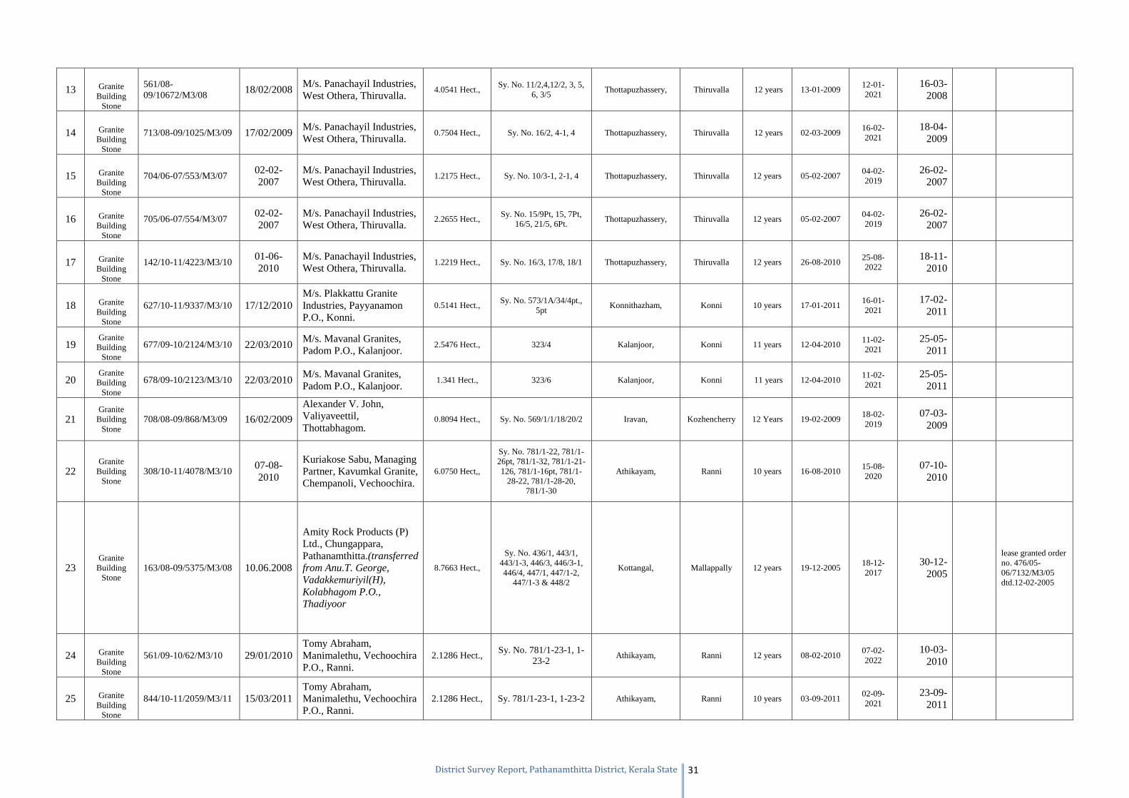
13 Granite Building
Stone
561/08-09/10672/M3/08 18/02/2008
M/s. Panachayil Industries, West Othera, Thiruvalla.
4.0541 Hect., Sy. No. 11/2,4,12/2, 3, 5,
6, 3/5 Thottapuzhassery, Thiruvalla 12 years 13-01-2009
12-01-2021
16-03-2008
14 Granite Building
Stone
713/08-09/1025/M3/09 17/02/2009 M/s. Panachayil Industries, West Othera, Thiruvalla.
0.7504 Hect., Sy. No. 16/2, 4-1, 4 Thottapuzhassery, Thiruvalla 12 years 02-03-2009 16-02-2021
18-04-2009
15 Granite Building
Stone
704/06-07/553/M3/07 02-02-2007
M/s. Panachayil Industries, West Othera, Thiruvalla.
1.2175 Hect., Sy. No. 10/3-1, 2-1, 4 Thottapuzhassery, Thiruvalla 12 years 05-02-2007 04-02-2019
26-02-2007
16 Granite Building
Stone
705/06-07/554/M3/07 02-02-2007
M/s. Panachayil Industries, West Othera, Thiruvalla.
2.2655 Hect., Sy. No. 15/9Pt, 15, 7Pt,
16/5, 21/5, 6Pt. Thottapuzhassery, Thiruvalla 12 years 05-02-2007
04-02-2019
26-02-2007
17 Granite Building
Stone
142/10-11/4223/M3/10 01-06-2010
M/s. Panachayil Industries, West Othera, Thiruvalla.
1.2219 Hect., Sy. No. 16/3, 17/8, 18/1 Thottapuzhassery, Thiruvalla 12 years 26-08-2010 25-08-2022
18-11-2010
18 Granite Building
Stone
627/10-11/9337/M3/10 17/12/2010 M/s. Plakkattu Granite Industries, Payyanamon P.O., Konni.
0.5141 Hect., Sy. No. 573/1A/34/4pt.,
5pt Konnithazham, Konni 10 years 17-01-2011
16-01-2021
17-02-2011
19 Granite
Building Stone
677/09-10/2124/M3/10 22/03/2010 M/s. Mavanal Granites, Padom P.O., Kalanjoor.
2.5476 Hect., 323/4 Kalanjoor, Konni 11 years 12-04-2010 11-02-2021
25-05-2011
20 Granite
Building Stone
678/09-10/2123/M3/10 22/03/2010 M/s. Mavanal Granites, Padom P.O., Kalanjoor.
1.341 Hect., 323/6 Kalanjoor, Konni 11 years 12-04-2010 11-02-2021
25-05-2011
21 Granite
Building Stone
708/08-09/868/M3/09 16/02/2009
Alexander V. John, Valiyaveettil, Thottabhagom.
0.8094 Hect., Sy. No. 569/1/1/18/20/2 Iravan, Kozhencherry 12 Years 19-02-2009 18-02-2019
07-03-2009
22 Granite
Building Stone
308/10-11/4078/M3/10 07-08-2010
Kuriakose Sabu, Managing Partner, Kavumkal Granite, Chempanoli, Vechoochira.
6.0750 Hect,,
Sy. No. 781/1-22, 781/1-26pt, 781/1-32, 781/1-21-126, 781/1-16pt, 781/1-
28-22, 781/1-28-20, 781/1-30
Athikayam, Ranni 10 years 16-08-2010 15-08-2020
07-10-2010
23 Granite
Building Stone
163/08-09/5375/M3/08 10.06.2008
Amity Rock Products (P) Ltd., Chungappara, Pathanamthitta.(transferred from Anu.T. George, Vadakkemuriyil(H), Kolabhagom P.O., Thadiyoor
8.7663 Hect.,
Sy. No. 436/1, 443/1, 443/1-3, 446/3, 446/3-1, 446/4, 447/1, 447/1-2,
447/1-3 & 448/2
Kottangal, Mallappally 12 years 19-12-2005 18-12-2017
30-12-2005
lease granted order no. 476/05-06/7132/M3/05 dtd.12-02-2005
24 Granite Building
Stone
561/09-10/62/M3/10 29/01/2010 Tomy Abraham, Manimalethu, Vechoochira P.O., Ranni.
2.1286 Hect., Sy. No. 781/1-23-1, 1-
23-2 Athikayam, Ranni 12 years 08-02-2010
07-02-2022
10-03-2010
25 Granite Building
Stone
844/10-11/2059/M3/11 15/03/2011 Tomy Abraham, Manimalethu, Vechoochira P.O., Ranni.
2.1286 Hect., Sy. 781/1-23-1, 1-23-2 Athikayam, Ranni 10 years 03-09-2011 02-09-2021
23-09-2011
Page 33
District Survey Report, Pathanamthitta District, Kerala State 32
26 Granite Building
Stone
509/04-05/7740/M3/2004.
17/11/2004 M/s. Darshan Granite (P) Ltd., Kulathumon P.O., Kalanjoor.
3.6700 Hect., (Govt. land)
Sy. No. 31/1 (Block 33) Part II
Adoor, Kalanjoor 12 years 26/11/2004 25-11-2016
Govt. land
27 Granite Building
Stone
323/11-12/6241/M3/11 26/08/2011 M/s. Darshan Granite (P) Ltd., Kulathumon P.O., Kalanjoor.
0.6095 hect., Sy. 129/2, 3 Koodal, Adoor 10 yrs. 28/09/2011 27-09-2021
14-11-2011
28 Granite Building
Stone
24/07-08/1971/M3/07 17/04/2007 K.J. Thomaskutty, Kannamthanam house, Vadasserikara.
1.0670 Hect., Sy. No. 319/2, 319/3,
319/10 & 319/4 (Block No. 31)
Vadasserikkara, Ranni 12 years 20/04/2007 19-04-2019
29-05-2007
29 Granite
Building Stone
25/07-08/1970/M3/07 17/04/2008 K.J. Thomaskutty, Kannamthanam house, Vadasserikara.
0.7860 Hect., Sy. No.317/7, 317/5, 317/4 & 317/6 (Block
No. 31) Vadasserikkara, Ranni 12 years 20/04/2007
19-04-2019
29-05-2007
30 Granite
Building Stone
322/07-08/5809/M3/07 17/08/2007 K.J. Thomaskutty, Kannamthanam house, Vadasserikara.
1.2382 Hect., Sy. No. 9/7Pt., 9/10Pt. Vadasserikkara, Ranni 12 years 06-09-2007 05-09-2019
05-11-2007
31 Granite
Building Stone
811/06-07/470/M3/2006
21-03-2007
A.I. Pothen, Mg. Partner, Mount Zion Granites, Aloth House, South Pampady P.O., Kottayam. (transferred from Smt.K.G. Vijayamma, Charanakkal, Malayalapuzha P.O.)
1.1660 Hect., Sy. No. 267/1, 2,3,4,
Block-18 Malayalapuzha, Kozhenchery 12 years 08-02-2006
07-02-2018
30-03-2006
lease granted order no. 616/05-06/470/M3/06 dtd. 31.01.2006
32 Granite
Building Stone
830/06-07/692/M3/07 27-03-2007
Jobin Varghese, Managing Director, Pyramid Granites, Padappara, Athirunkal, Koodal. 1.6710 Hect.,
Sy. No. 45/1,2,4, Block-32
Koodal, Konni 10 years 09-04-2007 08-04-2017
28-04-2007
33 Granite
Building Stone
681/12-13/2293/M3/12 18-12-2012
M/s. Kachanath Minerals & Metals (P) Ezhumattoor P.O., Mallappally (transferred from T. Mathew Abraham, Thekkumoottil, Vallamkulam, Thiruvalla)
2.1174 Hect., Sy. No. 135/2-3, 4-1, 6,7 Ezhumattoor, Mallappally 10 years 16-04-2008 15-04-2018
10-01-2013
lease granted order no. 23/2008-09/3245/M3/2008 dtd.18.12.2012
34 Granite
Building Stone
477/09-10/9529/M3/09 16-12-2009
V.R. Ajayakumar, Valluzhathil, Kuravankuzhy P.O., Pullad, Thiruvalla.
1.8813 Hect., Sy. No. 6/3Pt., 6/4, 5Pt., 9/2, 3Pt., 4Pt., 5, 6Pt., 7
Ezhumattoor, Mallappally 12 years 28-12-2009 27-12-2021
21-04-2010
35 Granite
Building Stone
549/09-10/9686/M3/09 27-01-2010
Surya Granites, Aseena Manzil, House No. 16/789, Meenadu East, Chathannoor, Kollam. 0.6268 Hect., Sy. No. 837/1D3-2, 1D-5 Perunadu, Ranni 12 years 01-02-2010
31-01-2022
04-03-2010
36 Granite
Building Stone
589/09-10/1291/M3/10 17-02-2010
Pratheesh T.M., Thankayathil, Manappally P.O., Thazhava, Kollam. 0.4200 Hect.,
Sy. No. 572/2Pt., 3Pt., 15Pt., 573/14
Pallickal, Adoor 12 years 19-02-2010 18-02-2022
04-03-2010
37 Granite
Building Stone
615/09-10/163/M3/10 04-03-2010
T. Ajayan, Cheruvallil house, Kombayar P.O., Idukki.
1.8218 Hect., Sy. No. 923/1-178-3Pt.,
923/1-191-1Pt. Perunadu, Ranni 12 Years 08-03-2010
07-03-2021
06-05-2010
Page 34
District Survey Report, Pathanamthitta District, Kerala State 33
38 Granite
Building Stone
308/10-11/5587/M3/10 17-08-2010
K.M. Mathew, Kuzhuvommannil, Kuravankuzhy P.O., Pullad.
0.6751 Hect., Sy. No. 2/1pt., 2pt., 3pt.,
4pt, 5pt. Thottapuzhassery, Thiruvalla 12 years 21-08-2010
20-08-2022
27-09-2010
39 Granite Building
Stone
700/11-12/8178/M3/11 13-01-2012
K.M. Mathew, Kuzhuvommannil, Kuravankuzhy P.O., Pullad.
13.80 Ares, Sy. 13/19, 13/9-1, 13/9-2
Block 24 Thottapuzhassery, Thiruvalla 7 yrs. 23-01-2012
22-01-2019
29-02-2012
40 Granite
Building Stone
328/10-11/5592/M3/10 20-08-2010
K.M. Mathew, Kuzhuvommannil, Kuravankuzhy P.O., Pullad.
0.2410 Hect., Sy. No. 3/1pt., 2pt., 2/1pt. Thottapuzhassery, Thiruvalla 12 years 21-08-2010 21-08-2022
27-09-2010
41 Granite
Building Stone
585/12-13/6003/M3/12 08-11-2012
Johnson Rocks, Vechoochira P.O., Ranni, Pathanamthitta (transferred from C.G. Sunu, Chirayil House, Vilakkudi P.O., Kunnicode, Kollam).
8.9236 Hect., Sy. No. 781/1-23-1, 23-2 Athikayam, Ranni 12 years 18-10-2010 17-10-2022
06-01-2011
lease granted order no.379/10-11/5535/M3/2010 dtd.07-08-2010
42 Granite
Building Stone
547/12-13/6002/M3/12 25-10-2012
Johnson Rocks, Vechoochira P.O., Ranni, Pathanamthitta (transferred from C.G. Sunu, Chirayil House, Vilakkudi P.O., Kunnicode, Kollam).
0.8094 Hect., Sy. No. 781/1-23-1 Athikayam, Ranni 12 years 18-10-2010 17-10-2022
06-01-2011
lease granted order no.311/10-11/5534/M3/2010 dtd.07-08-2010
43 Granite
Building Stone
630/10-11/9359/M3/10 20-12-2010 Johnson Rocks, Payyanamon, Konni, Pathanamthitta 0.9120 Hect., Sy. 569/1-1-18-20-2-1-3 Iravan, Kozhencherry 10 years 13-06-2011
12-06-2021
16-02-2011
44 Granite
Building Stone
836/10-11/9398/M3/10 11-03-2011
T. Mathew Abraham, Southern Rock & aggregate mining company, Vallamkulam, Thiruvalla
5 hect., Sy. 626/1 Pazhavangadi, Ranni 12 years 23-03-2011 22-03-2023
22-06-2011
Govt. land
45 Granite
Building Stone
44/11-12/2104/M3/11 29-04-2011 K. Sadanandan, Managing Partner, J&S Granites, V.Kottayam.
0.3200 Hect., Sy. 152/6 V. Kottayam, Kozhencherry 10 yrs. 11-05-2011 10-05-2021
18-06-2011
46 Granite
Building Stone
47/11-12/2105/M3/11 29-04-2011 K. Sadanandan, Managing Partner, J&S Granites, V.Kottayam.
0.1500 hect., Sy. 146/1 V. Kottayam, Kozhencherry 10 yrs. 11-05-2011 10-05-2021
18-06-2011
47 Granite
Building Stone
45/11-12/2103/M3/11 29-04-2011 K. Sadanandan, Managing Partner, J&S Granites, V.Kottayam.
0.7300 hect., Sy. 152/12, 10, 14, 15, 8 V. Kottayam, Kozhencherry 10 yrs. 11-05-2011 10-05-2021
18-06-2011
48 Granite
Building Stone
632/10-11/9257/M3/10 20-12-2010
M/s. SNAPZ Builders & Properties (P) Ltd., Puthenveettil house, Pullikkanakku P.O., Kayamakulam.
4.4841 hect., Sy. 623/1-14, 623/1-63pt.,
623/1-90 Iravan, Kozhencherry 10 yrs. 12-01-2011
11-01-2021
17-02-2011
Page 35
District Survey Report, Pathanamthitta District, Kerala State 34
49 Granite
Building Stone
352/11-12/5408/M3/11 07-09-2011
Saju Aby Mathew, Kuzhuvommannilaya Kollakuzhiyil, Kuravankuzhy, Pulladu
0.1578 hect., Sy. 1/3-2pt. Thottapuzhassery, Thiruvalla 10 yrs. 20-09-2011 19-09-2021
17-10-2011
50 Granite
Building Stone
464/11-12/5634/M3/11 20-10-2011 Inchappara Sand & Granite (P) Ltd., Inchappara, Koodal
1.0806 hect., Sy. No. 166/2-6 Block 30 Koodal, Konni 12 yrs. 24-10-2011 23-10-2023
08-12-2011
51 Granite
Building Stone
426/11-12/5635/M3/11 07-10-2011 Inchappara Sand & Granite (P) Ltd., Inchappara, Koodal
0.4300 hect., Sy. No. 166/1 Block 30 Koodal, Konni 8 yrs. 24-10-2011 23-10-2019
08-12-2011
52 Granite
Building Stone
463/11-12/5629/M3/11 20-10-2011 Inchappara Sand & Granite (P) Ltd., Inchappara, Koodal
1.4810 hect., Sy. No. 166/2 Block 30 Koodal, Konni 12 yrs. 24-10-2011 23-10-2023
08-12-2011
53 Granite
Building Stone
834/11-12/9938/M3/11 18-02-2012 Inchappara Sand & Granite (P) Ltd., Inchappara, Koodal
1.0248 hect., Sy. No. 166/2-10 Block
30 Koodal, Konni 5 yrs. 02-05-2012
01-05-2017
17-05-2012
54 Granite
Building Stone
901/11-12/9936/M3/11 19-03-2012 Inchappara Sand & Granite (P) Ltd., Inchappara, Koodal
1.0617 hect., Sy. No. 166/2-7, 2-9
Block 30 Koodal, Konni 10 yrs. 02-05-2012
01-05-2022
17-05-2012
55 Granite
Building Stone
424/11-12/5770/M3/11 07-10-2011 Jayesh Thomas, Kannamthanathu, Vadasserikkara P.O.
0.2410 hect., Sy. No. 314/13. Vadasserikkara, Ranni 9 yrs. 09-11-2011 08-11-2020
04-01-2012
56 Granite
Building Stone
425/11-12/5631/M3/11 07-10-2011 Jayesh Thomas, Kannamthanathu, Vadasserikkara P.O.
0.2322 hect., Sy. No. 315/2. Vadasserikkara, Ranni 6 yrs. 09-11-2011 08-11-2017
04-01-2012
57 Granite
Building Stone
902/11-12/2241/M3/12 19-03-2012 N. Jagadeeswarakurup, Thushara, Parakkodu P.O., Pathanamthitta
0.3901 hect., Sy. 313/4pt., Block 25 Enadimangalam, Adoor 10 yrs. 28-03-2012 27-03-2022
03-04-2012
58 Granite
Building Stone
68/12-13/3664/M3/12 27-04-2012
Thomas Mathai, Chengalathu house, Pathanamthitta 2.1000 hect.,
Sy. 581/1-5-7, 575/1-3-6-2
Konnithazham, Konni 12 yrs. 04-05-2012 03-05-2024
19-05-2012
59 Granite
Building Stone
454/13-14/8112/M3/13 07-10-2013 Mavanal Granties (P) Ltd., Sreenikethan, Kalanjoor, Pathanamthitta
4.04694 Hect., 288/1pt. (Block 32) Koodal, Konni 10 yrs. 17-10-2013 02-08-2023
21-10-2013
Govt. land
60 Granite
Building Stone
1/14-15/2535/M3/14 01-04-2014
K.N. Madhusoodannan, Managing Partner, Vajra Rock Mining Industries, Sreenikethan, Kalanjoor
4.4924 Hect., 251/1pt. (Block 32) Koodal, Konni 10 years 02-04-2014 31-03-2024
05-04-2014
Govt. land
61 Granite
Dimension Stone
472/06-07/7104/M3/06 20-10-2006
J. Anandan, Kattumadathil house, Naduvilemuri, Pallickal, Mavelikara. 3.1220 Hect.,
Sy. No. 251/1, 248/2, 248/7
Koodal, Adoor 10 years 15-11-2006 14-11-2016
19-01-2007
62 Granite
Dimension Stone
168/08-09/6906/M3/08 19-05-2008
J. Anandan, Kattumadathil house, Naduvilemuri, Pallickal, Mavelikara.
1.9900 Hect., Sy. No. 288/1 Koodal, Adoor 10 years 07-07-2008 06-07-2018
18-08-2008
63 Granite
Dimension Stone
330/08-09/7159/M3/08 01-09-2008
V.N. Raveendran Nair, Ravibhavan, Konni, Pathanamthitta
1.0324 Hect., Sy. 185/1,9, 186/5 Koodal, Adoor 9 years 06-10-2008 05-10-2017
19-06-2009
Page 36
District Survey Report, Pathanamthitta District, Kerala State 35
64 Granite
Dimension Stone
454/08-09/9211/M3/08 28-10-2008
K.P. Granite Industries, TC No. 36/999, Sreesanth, T.R. Sukumaran Nair, Road, Peruvanthani, Thiruvananthapuram.
2.0925 Hect., Sy. No. 31/1Pt. Kalanjoor, Adoor 10 years 31-12-2008 30-12-2018
28-04-2009
Page 37
District Survey Report, Pathanamthitta District, Kerala State 36
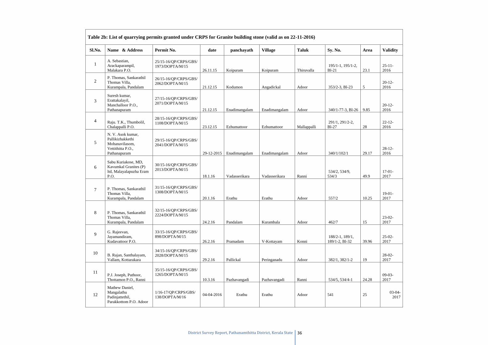
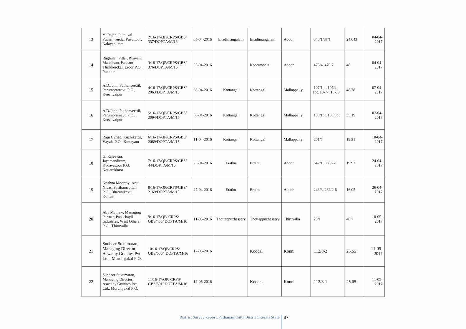
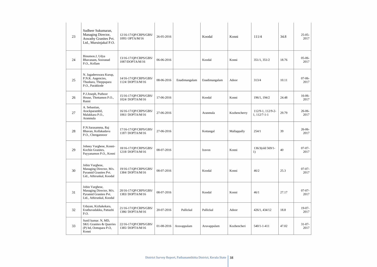
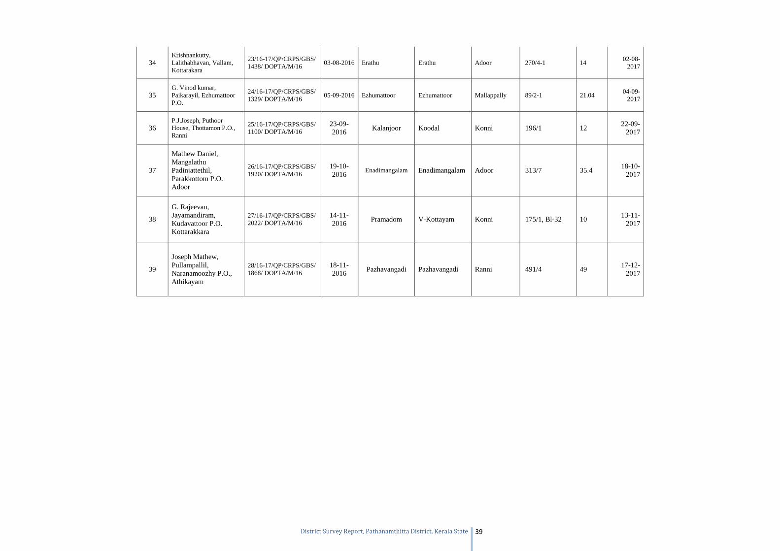
Table 2b: List of quarrying permits granted under CRPS for Granite building stone (valid as on 22-11-2016)
Sl.No. Name & Address Permit No. date panchayath Village Taluk Sy. No. Area Validity
1 A. Sebastian, Arackaparampil, Malakara P.O.
25/15-16/QP/CRPS/GBS/ 1973/DOPTA/M/15
26.11.15 Koipuram Koipuram Thiruvalla 195/1-1, 195/1-2, Bl-21 23.1
25-11-2016
2 P. Thomas, Sankarathil Thomas Villa, Kurampala, Pandalam
26/15-16/QP/CRPS/GBS/ 2062/DOPTA/M/15
21.12.15 Kodumon Angadickal Adoor 353/2-3, Bl-23 5 20-12-2016
3 Suresh kumar, Erattakalayil, Manchalloor P.O., Pathanapuram
27/15-16/QP/CRPS/GBS/ 2071/DOPTA/M/15
21.12.15 Enadimangalam Enadimangalam Adoor 340/1-77-3, Bl-26 9.85 20-12-2016
4 Raju. T.K., Thumbolil, Chalappalli P.O.
28/15-16/QP/CRPS/GBS/ 1108/DOPTA/M/15
23.12.15 Ezhumattoor Ezhumattoor Mallappalli 291/1, 291/2-2, Bl-27 28
22-12-2016
5
N. V. Asok kumar, Pallikizhakkethi Mohanavilasom, Vettithitta P.O., Pathanapuram
29/15-16/QP/CRPS/GBS/ 2041/DOPTA/M/15
29-12-2015 Enadimangalam Enadimangalam Adoor 340/1/102/1 29.17 28-12-2016
6 Sabu Kuriakose, MD, Kavumkal Granites (P) ltd, Malayalapuzha Eram P.O.
30/15-16/QP/CRPS/GBS/ 2013/DOPTA/M/15
18.1.16 Vadasserikara Vadasserikara Ranni 534/2, 534/9, 534/3 49.9
17-01-2017
7 P. Thomas, Sankarathil Thomas Villa, Kurampala, Pandalam
31/15-16/QP/CRPS/GBS/ 1308/DOPTA/M/15
20.1.16 Erathu Erathu Adoor 557/2 10.25 19-01-2017
8 P. Thomas, Sankarathil Thomas Villa, Kurampala, Pandalam
32/15-16/QP/CRPS/GBS/ 2224/DOPTA/M/15
24.2.16 Pandalam Kurambala Adoor 462/7 15 23-02-2017
9 G. Rajeevan, Jayamandiram, Kudavattoor P.O.
33/15-16/QP/CRPS/GBS/ 898/DOPTA/M/15
26.2.16 Pramadam V-Kottayam Konni 188/2-1, 189/1, 189/1-2, Bl-32 39.96
25-02-2017
10 B. Rajan, Santhalayam, Vallam, Kottarakara
34/15-16/QP/CRPS/GBS/ 2028/DOPTA/M/15
29.2.16 Pallickal Peringanadu Adoor 382/1, 382/1-2 19 28-02-2017
11 P.J. Joseph, Puthoor, Thottamon P.O., Ranni
35/15-16/QP/CRPS/GBS/ 1265/DOPTA/M/15
10.3.16 Pazhavangadi Pazhavangadi Ranni 534/5, 534/4-1 24.28 09-03-2017
12
Mathew Daniel, Mangalathu Padinjattethil, Parakkottom P.O. Adoor
1/16-17/QP/CRPS/GBS/ 138/DOPTA/M/16
04-04-2016 Erathu Erathu Adoor 541 25 03-04-
2017
Page 38
District Survey Report, Pathanamthitta District, Kerala State 37
13 V. Rajan, Puthuval Puthen veedu, Puvattoor, Kalayapuram
2/16-17/QP/CRPS/GBS/ 337/DOPTA/M/16
05-04-2016 Enadimangalam Enadimangalam Adoor 340/1/87/1 24.043 04-04-
2017
14
Raghulan Pillai, Bhavani Mandiram, Panaam Thrikkoickal, Eroor P.O., Punalur
3/16-17/QP/CRPS/GBS/ 376/DOPTA/M/16
05-04-2016 Koorambala Adoor 476/4, 476/7 48 04-04-
2017
15 A.D.John, Puthenveettil, Perumbramavu P.O., Keezhvaipur
4/16-17/QP/CRPS/GBS/ 2063/DOPTA/M/15
08-04-2016 Kottangal Kottangal Mallappally 107/1pt, 107/4-1pt, 107/7, 107/8
48.78 07-04-
2017
16 A.D.John, Puthenveettil, Perumbramavu P.O., Keezhvaipur
5/16-17/QP/CRPS/GBS/ 2094/DOPTA/M/15
08-04-2016 Kottangal Kottangal Mallappally 108/1pt, 108/3pt 35.19 07-04-
2017
17 Raju Cyriac, Kuzhikattil, Vayala P.O., Kottayam
6/16-17/QP/CRPS/GBS/ 2089/DOPTA/M/15
11-04-2016 Kottangal Kottangal Mallappally 201/5 19.31 10-04-
2017
18
G. Rajeevan, Jayamandiram, Kudavattoor P.O. Kottarakkara
7/16-17/QP/CRPS/GBS/ 44/DOPTA/M/16
25-04-2016 Erathu Erathu Adoor 542/1, 538/2-1 19.97 24-04-
2017
19
Krishna Moorthy, Anju Nivas, Sasthamcottah P.O., Bharanikavu, Kollam
8/16-17/QP/CRPS/GBS/ 2169/DOPTA/M/15
27-04-2016 Erathu Erathu Adoor 243/3, 232/2-6 16.05 26-04-
2017
20
Aby Mathew, Managing Partner, Panachayil Industries, West Othera P.O., Thiruvalla
9/16-17/QP/ CRPS/ GBS/455/ DOPTA/M/16
11-05-2016 Thottappuzhassery Thottappuzhassery Thiruvalla 20/1 46.7 10-05-
2017
21
Sudheer Sukumaran, Managing Director, Aswathy Granites Pvt. Ltd., Muruinjakal P.O.
10/16-17/QP/CRPS/ GBS/600/ DOPTA/M/16
12-05-2016 Koodal Konni 112/8-2 25.65 11-05-
2017
22
Sudheer Sukumaran, Managing Director, Aswathy Granites Pvt. Ltd., Muruinjakal P.O.
11/16-17/QP/ CRPS/ GBS/601/ DOPTA/M/16
12-05-2016 Koodal Konni 112/8-1 25.65 11-05-
2017
Page 39
District Survey Report, Pathanamthitta District, Kerala State 38
23
Sudheer Sukumaran, Managing Director, Aswathy Granites Pvt. Ltd., Muruinjakal P.O.
12/16-17/QP/CRPS/GBS/ 1095/ OPTA/M/16
26-05-2016 Koodal Konni 111/4 34.8 25-05-2017
24 Binumon.J, Udya Bhavanam, Sooranad P.O., Kollam
13/16-17/QP/CRPS/GBS/ 1087/DOPTA/M/16
06-06-2016 Koodal Konni 351/1, 351/2 18.76 05-06-
2017
25
N. Jagadeeswara Kurup, P.N.K. Aagencies, Thushara, Theppupara P.O., Parakkode
14/16-17/QP/CRPS/GBS/ 1124/ DOPTA/M/16
08-06-2016 Enadimangalam Enadimangalam Adoor 313/4 10.11 07-06-
2017
26 P.J.Joseph, Puthoor House, Thottamon P.O., Ranni
15/16-17/QP/CRPS/GBS/ 1024/ DOPTA/M/16
17-06-2016 Koodal Konni 196/1, 194/2 24.48 16-06-
2017
27
A. Sebastian, Arackparambil, Malakkara P.O., Aranmula
16/16-17/QP/CRPS/GBS/ 1061/ DOPTA/M/16
27-06-2016 Aranmula Kozhencherry 112/9-1, 112/9-2-1, 112/7-1-1
29.79 26-06-
2017
28 P.N.Sarasamma, Raj Bhavan, Kollakadavu P.O., Chengannoor
17/16-17/QP/CRPS/GBS/ 1187/ DOPTA/M/16
27-06-2016 Kottangal Mallappally 254/1 39 26-06-
2017
29 Johney Varghese, Konni-Kochin Granites, Payyanamon P.O., Konni
18/16-17/QP/CRPS/GBS/ 1218/ DOPTA/M/16
08-07-2016 Iravon Konni 136/3(old 569/1-1)
40 07-07-
2017
30
Jobin Varghese, Managing Director, M/s. Pyramid Granites Pvt. Ltd., Athirunkal, Koodal
19/16-17/QP/CRPS/GBS/ 1384/ DOPTA/M/16
08-07-2016 Koodal Konni 46/2 25.3 07-07-
2017
31
Jobin Varghese, Managing Director, M/s. Pyramid Granites Pvt. Ltd., Athirunkal, Koodal
20/16-17/QP/CRPS/GBS/ 1383/ DOPTA/M/16
08-07-2016 Koodal Konni 46/1 27.17 07-07-
2017
32 Udayan, Kizhakekara, Erathuvadakku, Pattazhi P.O.
21/16-17/QP/CRPS/GBS/ 1386/ DOPTA/M/16
20-07-2016 Pallickal Pallickal Adoor 426/1, 434/12 18.8 19-07-
2017
33
Sunil kumar. N, MD, SKG Granites & Quarries (P) ltd, Oottupara P.O, Konni
22/16-17/QP/CRPS/GBS/ 1385/ DOPTA/M/16
01-08-2016 Aruvappulam Aruvappulam Kozhencheri 540/1-1-411 47.02 31-07-
2017
Page 40
District Survey Report, Pathanamthitta District, Kerala State 39
34 Krishnankutty, Lalithabhavan, Vallam, Kottarakara
23/16-17/QP/CRPS/GBS/ 1438/ DOPTA/M/16
03-08-2016 Erathu Erathu Adoor 270/4-1 14 02-08-
2017
35 G. Vinod kumar, Paikarayil, Ezhumattoor P.O.
24/16-17/QP/CRPS/GBS/ 1329/ DOPTA/M/16
05-09-2016 Ezhumattoor Ezhumattoor Mallappally 89/2-1 21.04 04-09-
2017
36 P.J.Joseph, Puthoor House, Thottamon P.O., Ranni
25/16-17/QP/CRPS/GBS/ 1100/ DOPTA/M/16
23-09-2016
Kalanjoor Koodal Konni 196/1 12 22-09-
2017
37
Mathew Daniel, Mangalathu Padinjattethil, Parakkottom P.O. Adoor
26/16-17/QP/CRPS/GBS/ 1920/ DOPTA/M/16
19-10-2016
Enadimangalam Enadimangalam Adoor 313/7 35.4 18-10-
2017
38
G. Rajeevan, Jayamandiram, Kudavattoor P.O. Kottarakkara
27/16-17/QP/CRPS/GBS/ 2022/ DOPTA/M/16
14-11-2016
Pramadom V-Kottayam Konni 175/1, Bl-32 10 13-11-
2017
39
Joseph Mathew, Pullampallil, Naranamoozhy P.O., Athikayam
28/16-17/QP/CRPS/GBS/ 1868/ DOPTA/M/16
18-11-2016
Pazhavangadi Pazhavangadi Ranni 491/4 49 17-12-
2017
Page 41
District Survey Report, Pathanamthitta District, Kerala State 40
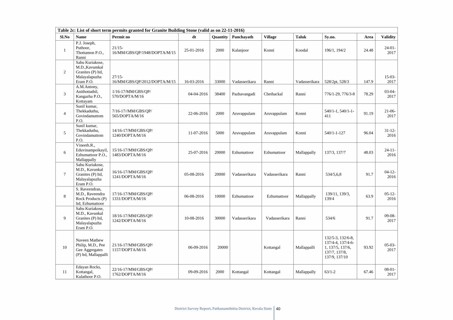
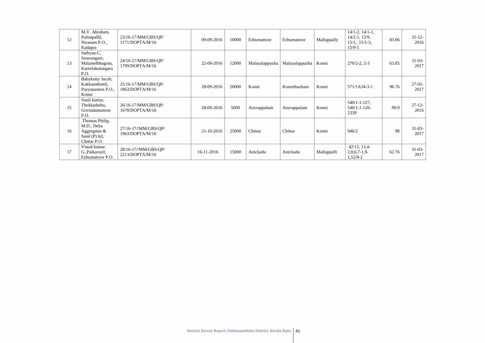
Table 2c: List of short term permits granted for Granite Building Stone (valid as on 22-11-2016) Sl.No Name Permit no dt Quantity Panchayath Village Taluk Sy.no. Area Validity
1
P.J. Joseph, Puthoor, Thottamon P.O., Ranni
21/15-16/MM/GBS/QP/1948/DOPTA/M/15
25-01-2016 2000 Kalanjoor Konni Koodal 196/1, 194/2 24.48 24-01-
2017
2
Sabu Kuriakose, M.D.,Kavumkal Granites (P) ltd, Malayalapuzha Eram P.O.
27/15-16/MM/GBS/QP/2012/DOPTA/M/15 16-03-2016 33000 Vadasserikara Ranni Vadasserikara 528/2pt, 528/3 147.9
15-03-2017
3
A.M.Antony, Anithottathil, Kangazha P.O., Kottayam
1/16-17/MM/GBS/QP/ 570/DOPTA/M/16
04-04-2016 38400 Pazhavangadi Chethackal Ranni 776/1-29, 776/3-8 78.29 03-04-
2017
4
Sunil kumar, Thekkaduthu, Govindamuttom P.O.
7/16-17//MM/GBS/QP/ 565/DOPTA/M/16
22-06-2016 2000 Aruvappulam Aruvappulam Konni 540/1-1, 540/1-1-411
91.19 21-06-
2017
5
Sunil kumar, Thekkaduthu, Govindamuttom P.O.
14/16-17/MM/GBS/QP/ 1240/DOPTA/M/16
11-07-2016 5000 Aruvappulam Aruvappulam Konni 540/1-1-127 96.04 31-12-
2016
6
Vineeth.R., Eduvinampoikayil, Ezhumattoor P.O., Mallappally
15/16-17/MM/GBS/QP/ 1483/DOPTA/M/16
25-07-2016 20000 Ezhumattoor Ezhumattoor Mallappally 137/3, 137/7 48.03 24-11-
2016
7
Sabu Kuriakose, M.D., Kavunkal Granites (P) ltd, Malayalapuzha Eram P.O.
16/16-17/MM/GBS/QP/ 1241/DOPTA/M/16
05-08-2016 20000 Vadasserikara Vadasserikara Ranni 534/5,6,8 91.7 04-12-
2016
8
S. Raveendran, M.D., Raveendra Rock Products (P) ltd, Ezhumattoor
17/16-17/MM/GBS/QP/ 1331/DOPTA/M/16
06-08-2016 10000 Ezhumattoor Ezhumattoor Mallappally 139/11, 139/3, 139/4
63.9 05-12-
2016
9
Sabu Kuriakose, M.D., Kavunkal Granites (P) ltd, Malayalapuzha Eram P.O.
18/16-17/MM/GBS/QP/ 1242/DOPTA/M/16
10-08-2016 30000 Vadasserikara Vadasserikara Ranni 534/6 91.7 09-08-
2017
10
Naveen Mathew Philip, M.D., Pee Gee Aggregates (P) ltd, Mallappalli
21/16-17/MM/GBS/QP/ 1157/DOPTA/M/16
06-09-2016 20000 Kottangal Mallappalli
132/5-3, 132/6-8, 137/4-4, 137/4-6-1, 137/5, 137/6, 137/7, 137/8, 137/9, 137/10
93.92 05-03-
2017
11 Edayan Rocks, Kottangal, Kulathoor P.O.
22/16-17/MM/GBS/QP/ 1762/DOPTA/M/16
09-09-2016 2000 Kottangal Kottangal Mallappally 63/1-2 67.46 08-01-
2017
Page 42
District Survey Report, Pathanamthitta District, Kerala State 41
12
M.V. Abraham, Pulimpallil, Niranam P.O., Kadapra
23/16-17/MM/GBS/QP/ 1171/DOPTA/M/16
09-09-2016 10000 Ezhumattoor Ezhumattoor Mallappally
14/1-2, 14/1-1, 14/2-1, 15/9, 15/1,. 15/1-3, 15/9-1
83.06 31-12-
2016
13
Sathyan.C, Sreerangam, Malamelbhagom, Kareelakulangara P.O.
24/16-17/MM/GBS/QP/ 1799/DOPTA/M/16
22-09-2016 12000 Malayalappuzha Malayalappuzha Konni 270/2-2, 2-3 63.85 31-03-
2017
14
Babykutty Jacob, Kakkamthottil, Payyanamon P.O., Konni
25/16-17/MM/GBS/QP/ 1863/DOPTA/M/16
28-09-2016 20000 Konni Konnithazham Konni 571/1A34-3-1 96.76 27-02-
2017
15
Sunil kumar, Thekkaduthu, Govindamuttom P.O.
26/16-17/MM/GBS/QP/ 1678/DOPTA/M/16
28-09-2016 5000 Aruvappulam Aruvappulam Konni 540/1-1-127, 540/1-1-126-2339
99.9 27-12-
2016
16
Thomas Philip, M.D., Delta Aggregates & Sand (P) ltd, Chittar P.O.
27/16-17//MM/GBS/QP/ 1963/DOPTA/M/16
21-10-2016 25000 Chittar Chittar Konni 946/2 98 31-03-
2017
17 Vinod kumar. G.,Paikarayil, Ezhumattoor P.O.
28/16-17//MM/GBS/QP/ 2213/DOPTA/M/16
16-11-2016 15000 Anickadu Anickadu Mallappalli 42/12, 13,4-2,8,6,7-1,9-1,52/8-2
62.76 31-03-
2017
Page 43
District Survey Report, Pathanamthitta District, Kerala State 42
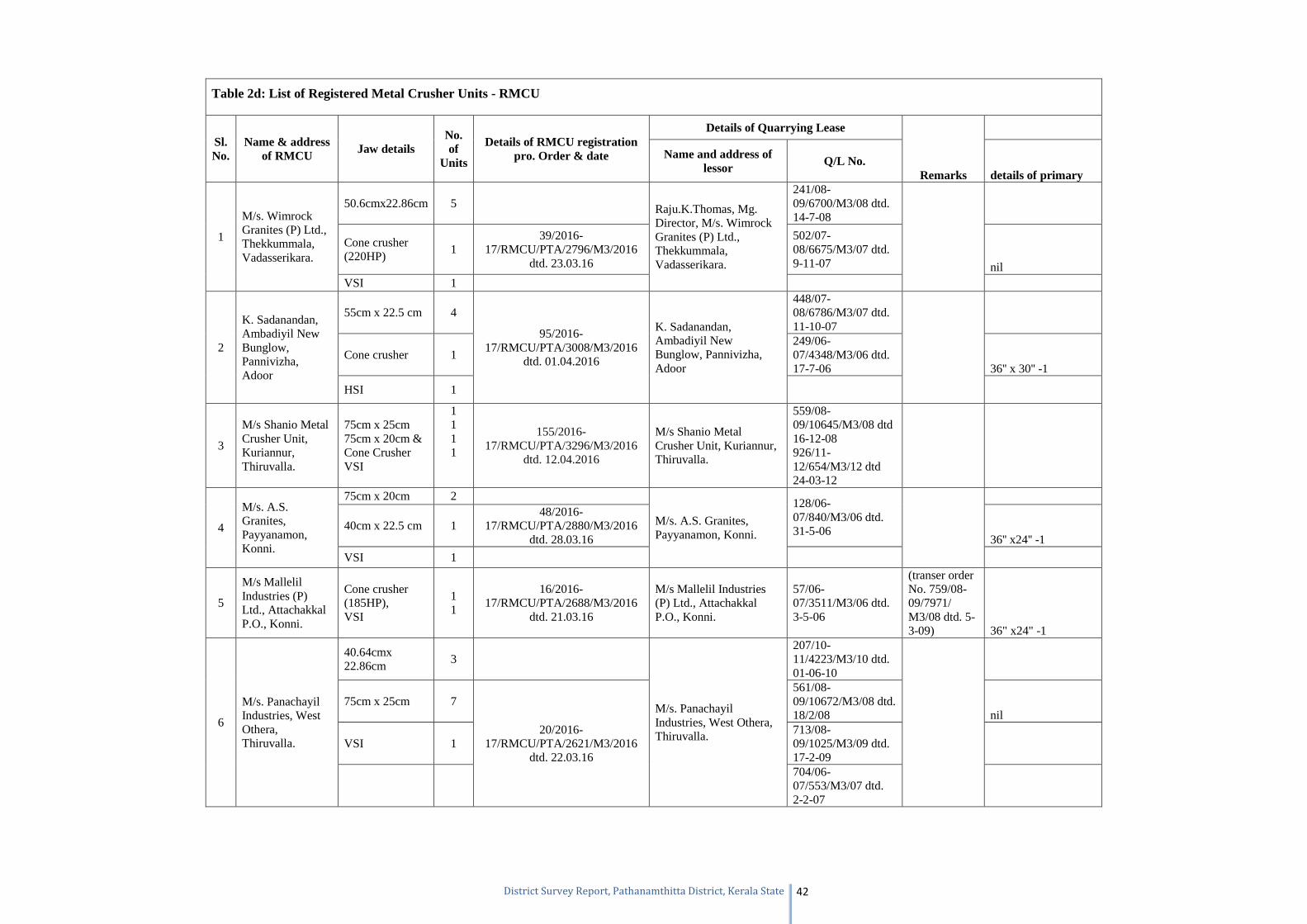
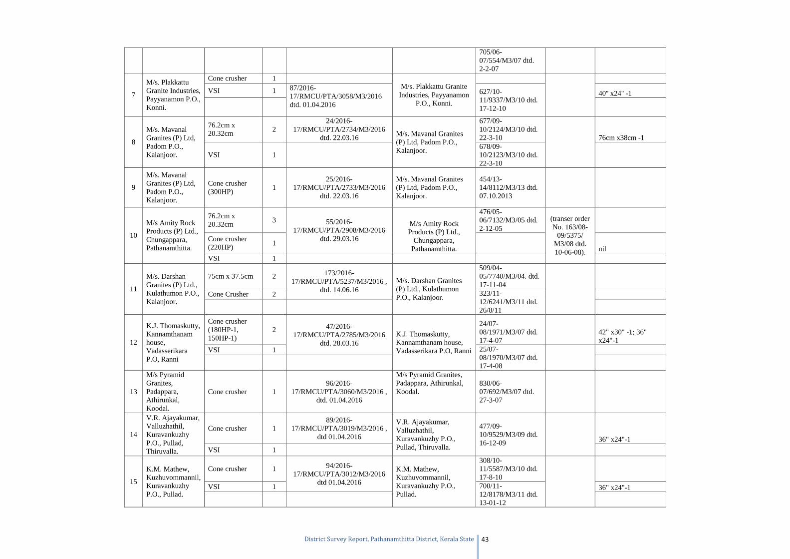
Table 2d: List of Registered Metal Crusher Units - RMCU
Sl. No.
Name & address of RMCU Jaw details
No. of
Units
Details of RMCU registration pro. Order & date
Details of Quarrying Lease
Remarks
Name and address of lessor Q/L No.
details of primary
1
M/s. Wimrock Granites (P) Ltd., Thekkummala, Vadasserikara.
50.6cmx22.86cm 5 Raju.K.Thomas, Mg. Director, M/s. Wimrock Granites (P) Ltd., Thekkummala, Vadasserikara.
241/08-09/6700/M3/08 dtd. 14-7-08
Cone crusher (220HP)
1 39/2016-
17/RMCU/PTA/2796/M3/2016 dtd. 23.03.16
502/07-08/6675/M3/07 dtd. 9-11-07 nil
VSI 1
2
K. Sadanandan, Ambadiyil New Bunglow, Pannivizha, Adoor
55cm x 22.5 cm 4
95/2016-17/RMCU/PTA/3008/M3/2016
dtd. 01.04.2016
K. Sadanandan, Ambadiyil New Bunglow, Pannivizha, Adoor
448/07-08/6786/M3/07 dtd. 11-10-07
Cone crusher 1 249/06-07/4348/M3/06 dtd. 17-7-06 36'' x 30'' -1
HSI 1
3
M/s Shanio Metal Crusher Unit, Kuriannur, Thiruvalla.
75cm x 25cm 75cm x 20cm & Cone Crusher VSI
1 1 1 1
155/2016-17/RMCU/PTA/3296/M3/2016
dtd. 12.04.2016
M/s Shanio Metal Crusher Unit, Kuriannur, Thiruvalla.
559/08-09/10645/M3/08 dtd 16-12-08 926/11-12/654/M3/12 dtd 24-03-12
4
M/s. A.S. Granites, Payyanamon, Konni.
75cm x 20cm 2
M/s. A.S. Granites, Payyanamon, Konni.
128/06-07/840/M3/06 dtd. 31-5-06
40cm x 22.5 cm 1 48/2016-
17/RMCU/PTA/2880/M3/2016 dtd. 28.03.16 36'' x24'' -1
VSI 1
5
M/s Mallelil Industries (P) Ltd., Attachakkal P.O., Konni.
Cone crusher (185HP), VSI
1 1
16/2016-17/RMCU/PTA/2688/M3/2016
dtd. 21.03.16
M/s Mallelil Industries (P) Ltd., Attachakkal P.O., Konni.
57/06-07/3511/M3/06 dtd. 3-5-06
(transer order No. 759/08-09/7971/ M3/08 dtd. 5-3-09) 36" x24" -1
6
M/s. Panachayil Industries, West Othera, Thiruvalla.
40.64cmx 22.86cm
3
M/s. Panachayil Industries, West Othera, Thiruvalla.
207/10-11/4223/M3/10 dtd. 01-06-10
75cm x 25cm 7
20/2016-17/RMCU/PTA/2621/M3/2016
dtd. 22.03.16
561/08-09/10672/M3/08 dtd. 18/2/08 nil
VSI 1 713/08-09/1025/M3/09 dtd. 17-2-09
704/06-07/553/M3/07 dtd. 2-2-07
Page 44
District Survey Report, Pathanamthitta District, Kerala State 43
705/06-07/554/M3/07 dtd. 2-2-07
7
M/s. Plakkattu Granite Industries, Payyanamon P.O., Konni.
Cone crusher 1 M/s. Plakkattu Granite Industries, Payyanamon
P.O., Konni.
VSI 1 87/2016-
17/RMCU/PTA/3058/M3/2016 dtd. 01.04.2016
627/10-11/9337/M3/10 dtd. 17-12-10
40'' x24'' -1
8
M/s. Mavanal Granites (P) Ltd, Padom P.O., Kalanjoor.
76.2cm x 20.32cm
2 24/2016-
17/RMCU/PTA/2734/M3/2016 dtd. 22.03.16 M/s. Mavanal Granites
(P) Ltd, Padom P.O., Kalanjoor.
677/09-10/2124/M3/10 dtd. 22-3-10
76cm x38cm -1
VSI 1 678/09-10/2123/M3/10 dtd. 22-3-10
9
M/s. Mavanal Granites (P) Ltd, Padom P.O., Kalanjoor.
Cone crusher (300HP)
1 25/2016-
17/RMCU/PTA/2733/M3/2016 dtd. 22.03.16
M/s. Mavanal Granites (P) Ltd, Padom P.O., Kalanjoor.
454/13-14/8112/M3/13 dtd. 07.10.2013
10
M/s Amity Rock Products (P) Ltd., Chungappara, Pathanamthitta.
76.2cm x 20.32cm
3 55/2016-17/RMCU/PTA/2908/M3/2016
dtd. 29.03.16
M/s Amity Rock Products (P) Ltd.,
Chungappara, Pathanamthitta.
476/05-06/7132/M3/05 dtd. 2-12-05
(transer order No. 163/08-
09/5375/ M3/08 dtd. 10-06-08).
Cone crusher (220HP)
1 nil
VSI 1
11
M/s. Darshan Granites (P) Ltd., Kulathumon P.O., Kalanjoor.
75cm x 37.5cm 2 173/2016-17/RMCU/PTA/5237/M3/2016 ,
dtd. 14.06.16 M/s. Darshan Granites (P) Ltd., Kulathumon P.O., Kalanjoor.
509/04-05/7740/M3/04. dtd. 17-11-04
Cone Crusher 2 323/11-
12/6241/M3/11 dtd. 26/8/11
12
K.J. Thomaskutty, Kannamthanam house, Vadasserikara P.O, Ranni
Cone crusher (180HP-1, 150HP-1)
2 47/2016-17/RMCU/PTA/2785/M3/2016
dtd. 28.03.16 K.J. Thomaskutty, Kannamthanam house, Vadasserikara P.O, Ranni
24/07-08/1971/M3/07 dtd. 17-4-07
42" x30" -1; 36" x24"-1
VSI 1 25/07-08/1970/M3/07 dtd. 17-4-08
13
M/s Pyramid Granites, Padappara, Athirunkal, Koodal.
Cone crusher 1 96/2016-
17/RMCU/PTA/3060/M3/2016 , dtd. 01.04.2016
M/s Pyramid Granites, Padappara, Athirunkal, Koodal.
830/06-07/692/M3/07 dtd. 27-3-07
14
V.R. Ajayakumar, Valluzhathil, Kuravankuzhy P.O., Pullad, Thiruvalla.
Cone crusher 1 89/2016-
17/RMCU/PTA/3019/M3/2016 , dtd 01.04.2016
V.R. Ajayakumar, Valluzhathil, Kuravankuzhy P.O., Pullad, Thiruvalla.
477/09-10/9529/M3/09 dtd. 16-12-09
36" x24"-1
VSI 1
15
K.M. Mathew, Kuzhuvommannil, Kuravankuzhy P.O., Pullad.
Cone crusher 1 94/2016-17/RMCU/PTA/3012/M3/2016
dtd 01.04.2016
K.M. Mathew, Kuzhuvommannil, Kuravankuzhy P.O., Pullad.
308/10-11/5587/M3/10 dtd. 17-8-10
VSI 1 700/11-
12/8178/M3/11 dtd. 13-01-12
36" x24"-1
Page 45
District Survey Report, Pathanamthitta District, Kerala State 44
16
M/s Johnson Rocks, Payyanamon P.O., Konni, Pathanamthitta
40.64cm x 22.86cm
4 15/2016-
17/RMCU/PTA/2689/M3/2016 dtd. 21.03.16
Susamma John, Mg. Partner, M/s Johnson Rocks, Payyanamon, Konni, Pathanamthitta
708/08-09/868/M3/09 dtd 16-2-09
(transer order No. 325/09-10/7023/ M3/09 dtd. 24-9-09). 30" x 15" -1
VSI 1 630/10-11/9359/M3/10 dtd. 20-12-10
17
T. Mathew Abraham, Southern Rock & aggregate mining company, Vallamkulam, Thiruvalla
Cone crusher (150HP)
1 46/2016-
17/RMCU/PTA/2786/M3/2016 dtd. 28.03.16
T. Mathew Abraham, Southern Rock & aggregate mining company, Vallamkulam, Thiruvalla
836/10-11/9398/M3/10 dtd. 11-3-11
36" x24" -1
VSI 1
18 M/s J&S Granite Company, V-Kottayam
55cm x 22.5 cm 3
37/2014-15/RMCU/PTA/4151/M3/2014
dtd. 31.03.2014 K. Sadanandan, Mg. Partner, M/s J&S Granite Company, V-Kottayam
44/11-12/2104/M3/11 dtd. 29-4-11
47/11-12/2105/M3/11 dtd. 29-4-11 30" x24" -1
45/11-12/2103/M3/11 dtd. 29-4-11
19
K.Varkey Abraham, Mg. Director, M/s Kachanathu Minerals & Metals (P) Ltd., Ezhumattoor P.O., Mallappally
Cone Crusher 1 179/2016-
17/RMCU/PTA/7933/M3/2016 dtd. 26.08.16
K.Varkey Abraham, Mg. Director, M/s Kachanathu Minerals & Metals (P) Ltd., Ezhumattoor P.O., Mallappally
(transer order No. 681/12-
13/2293/ M3/12 dtd. 18-12-12).
23/08-09/3245/M3/08 dtd 07-04-08
36" x24" -1
Page 46
District Survey Report, Pathanamthitta District, Kerala State 45
References
1. District Resource Map, Pathanamthitta district, Kerala. Pubished by Geological Survey of
India.
2. Detailed Information on Bauxite in India Geological Survey of India. 1994. Retrieved from
http://www.portal.gsi.gov.in/gsiDoc/pub/DID_Bauxite_WM.pdf
3. Rajan, T. N. and Anil Kumar, P. S. 2005. Geology and Mineral Resources of the States of
India Part IX – Kerala. Geological Survey of India Miscellaneous Publication No. 30.
4. Murugan SS 2013. Ground Water Information Booklet of Pathanamthitta district, Kerala.
Technical Reports: Series ‘D’. Central Ground Water Board.
5. www.kerenvis.nic.in
6. www.keralasoils.gov.in
7. www.dmg.kerala.gov.in
Page 47
District Survey Report, Pathanamthitta District, Kerala State 46
Annexure 1: Geology of Kerala
Geology of Kerala
Physiography
Physiographically the state can be divided into four domains from east to west, viz., the Western
Ghats, the foothills, the midland and the coastal low- land.
Western Ghats
The hill ranges of the Western Ghats rise to an altitude of over 2500m above the MSL and the crest
of the ranges marks the inter-state boundary in most of the places. A breach in the continuity of the
ranges marks the Palghat Gap with a sinistral shift of 50 km between the shifted crests. The Wynad
plateau and the Munnar (1057'00": 7731'00") upland fall within this zone.
Foothills
The foothills of the Western Ghats comprise the rocky area from 200 to 600m.above MSL. It is a
transitional zone between the high -ranges and midland.
Midland region
This forms an area of gently undulating topography with hillocks and mounds. Laterite capping is
commonly noticeable on the top of these hillocks. The low, flat-topped hillocks forming the laterite
plateau range in altitude from 30-200m and are observed between coastal low-land and the foothills.
Coastal low- land
Coastal low-land is identified with alluvial plains, sandy stretches, abraded platforms, beach ridges,
raised beaches, lagoons and estuaries. The low- land and the plains are generally less than 10m above
MSL.
Rivers
Kerala is drained by 44 rivers, many of which orginate from the Western Ghats. Except Kabini,
Bhavani and Pambar which are east - flowing, the rest of rivers are west- flowing and join the Arabian
Sea. A few of them drain into the backwaters. Most important rivers (with their length in km in
paranthesis) of the state, are Chandragiri(105), Valapatnam (110), Achankovil (120) Kallada (121),
Muvattupuzha (121), Chalakudy (130), Kadalundi(130), Chaliyar (169), Pampa (176),Bharathapuzha
(209) and Periyar (244).
Page 48
District Survey Report, Pathanamthitta District, Kerala State 47
Geology
Geologically, Kerala is occupied by Precambrian crystallines, acid to ultra basic intrusives of
Archaean to Proterozoic age, Tertiary (Mio-Pliocene) sedimentary rocks and Quaternary sediments
of fluvial and marine origin (Fig.I). Both the crystallines and the Tertiary sediments have been
extensively lateritised.
Based on the detailed studies by GSI during the last three decades, the following stratigraphic
sequence has been suggested.
Page 49
District Survey Report, Pathanamthitta District, Kerala State 48
Base not recognised
Page 50
District Survey Report, Pathanamthitta District, Kerala State 49
The Archaeans
Rocks of Archaean Era encompass a wide spectrum of litho-assemblages ranging from khondalite,
charnockite, gneiss and meta-sedimentary rocks occupying the Western Ghats including the
foothill region. The Khondalite and Charnockite Group are correlated with the Eastern Ghat
Supergroup based on the overall similarity in lithology and geochronology.
Wynad Supracrustals
The meta-sedimentary, and ultramafic rocks occurring in the Wynad District generated keen
interest among the GSI geologists in 1970s. The high-grade Wynad supracrustal rocks are
correlated with the Sargur Schist Complex of the Karnataka (Nair, et al, 1975; Adiga, 1980). The
schistose rocks are characterised by intense deformation, medium to high-grade metamorphism,
migmatisation and lack of sedimentary structures. The schist complex consists of meta-
ultramafites, schist, meta-pelites, meta-pyroxenite, serpentinite, talc-tremolite rock and
amphibolite.
The meta-sedimentaries occur as thin linear bodies within the migmatites. These consist of pelites,
psammopelites and quartzites. The predominant rock types are corundum- mica schist, kyanite
schist, quartz- mica schist and iron stone.(Anil Kumar et al,1993).
These rocks occur as narrow arcuate belts, lenses, and other forms of enclaves within Peninsular
gneisses and charnockite. The group can be divided into medium-to low- grade metasedimentary
rocks and meta-mafic and meta-ultramafic rocks. The lithology of the high-grade schists consist
of quartz-mica schist with kyanite, quartz-sericite schists,quartzites,magnetite quartzite, fuchsite
quartzite and meta-ultramafites. Their contact with the surrounding gneisses are concordant due
to later co-folding. Several linear belts of such high-grade schists and ultramafite enclaves occur
as isolated bands within the granulite and gneissic terrain of Kasaragod and Kannur districts.
Layered ultrabasic- basic complex
Remnants of layered basic- ultabasic complex are reported from Attappadi area(Nambiar
1982).The ultramafics are represented by meta-pyroxenite, meta-dolerite, peridotite with chromite
and meta-gabbro (Lahiri et al, 1975). The anorthosite of Attappadi is only a few metre thick.
Occurrences are around Narsimukku, Pudur and Melmulli areas. An east-west trending narrow
lenticular body of serpentinised dunite is reported from Punalur mica mine belt.
A minor body (200 m long and 10-15m wide) of anorthosite was reported within pyroxene-
granulite-charnockite terrain from Katanjari parambu of Kasargod district (Adiga, 1979).
Page 51
District Survey Report, Ernakulam District, Kerala State 50
Another dismembered layered igneous complex consisting of alternate layers of peridotite and
pyroxenite within charnockite was traced around Panathadi area of Kannur District (Adiga,
1980).
Peninsular Gneissic Complex- I (PGC-I)
The rocks of Peninsular Gneissic Complex(PGC) are exposed in the northern parts of Kerala
adjoining Karnataka . This consists of a heterogeneous mixture of granitoid materials. The
equivalent rocks of PGC in Kerala include hornblende-biotite gneiss (sheared), biotite-
hornblende gneiss, foliated granite and pink granite gneiss. Granite gneiss is exposed along the
intra-State boundary of Palakkad District as well as in Idukki District. Pink granite gneiss,
though widespread, is best developed in Devikolam (1004'00": 7706'30"), and
Udumbanchola (10°00'00":77°15'00") areas of Idukki District.
This consists of gneisses showing preponderance of either hornblende or biotite. The
percentage of hornblende and biotite varies from place to place. This can be traced from
Manantoddy to further northwest upto the west coast. West of Manantoddy, the rock is
hornblende gneiss. It shows coarse granulitic to gneissic texture and is composed of
hornblende, feldspar, quartz, pyroxene, biotite and garnet. Alkali feldspar shows alteration to
clay and sericite. Biotite is mainly secondary after hornblende.
Around Mahe and Thalasseri, the biotite gneiss(Nair et al., 1974) is medium-grained and
gneissose rock consisting of alternate layers of mafics and felsics.
Khondalite Group
The Khondalite Group of rocks include calc-granulites, quartzite and para-gneisses of pelitic
parentage. Para-gneisses are ubiquitous and are well-developed in the southern part of the state,
particularly, in Thiruvananthapuram and Kollam districts. Calc-granulite and quartzite occur
as bands within the para-gneisses and amidst the Charnockite Group and migmatitic gneisses.
Calc-granulite
Calc-granulite occurs as linear bands mainly in the eastern part of Kollam and
Thiruvananthapuram District, northeast and east of Munnar in Idukki district and in parts of
Palakkad District. The rock is generally medium to coarse-grained, inequigranular and
granoblastic in texture. It consists of diopside and plagioclase. Minerals like wollastonite,
scapolite, calcite, garnet, spinel, sphene, quartz and apatite are also present in different
proportions.
Page 52
District Survey Report, Ernakulam District, Kerala State 51
Quartzite
Quartzite occurs as linear bands amidst the khondalitic gneiss, charnockite and migmatitic
gneisses. These bands are exposed between Pathanamthitta (915'45": 7647'00"), and
Muvattupuzha (959'00": 7635'00") in Ernakulam District. The rock is coarse-grained and
generally white in color with a brownish coating on the weathered surface. It consists of
granular quartz with subordinate feldspar, garnet and iron oxide.
Garnetiferous biotite-sillimanite gneiss
Garnetiferous biotite- sillimanite gneiss is well-developed in the southern part of the state. It
occurs in close association with the migmatitic gneisses, charnockite and charnockite gneisses,
mostly as weathered outcrops. Sillimanite- rich bands occur alternating with garnet - rich
portions or with quartzo-feldspathic layers. Rutile and iron oxides are the common accessory
minerals.
Charnockite Group
Charnockite Group shows great diversity in lithology comprising pyroxene granulite,
hornblende pyroxenite, magnetite quartzite, charnockite and hypersthene-diopside gneisses
and cordierite gneiss. Charnockite and charnockitic gneiss have preponderance over all other
crystalline rocks covering 40 -50% of the total area of the State. The charnockites are well-
exposed in the central and northern parts of Kerala including the high–hills of the Western
Ghats. Char nockite has lesser predominance in Thiruvananthapuram and Kollam districts. In
Attappady, the Bhavani Shear Zone is limited by the charnockite massif of the Nilgiri plateau
on the north. Though the interrelationship of the Charnockite and the Khondalite is not clear,
in many places there are intercalations rather than interlayering of one with the other. In
Palakkad District, the Khondalite Group of rocks structurally overlie the charnockite. The
occurrence of pyroxene granulite as fine and linear bodies within the charnockite of Tirur,
suggests that charnockite is a product of migmatisation of pyroxene granulite(Vidyadharan and
Sukumaran, 1978). Charnockite and charnockitic gneiss consist of quartz, feldspar and biotite.
Garnet-bearing variants are also observed. The basic charnockite is more granulitic and
contains clino- and ortho- pyroxenes, feldspar, biotite and garnet whereas the acid variety
(alaskite/ enderbite) is greenish black, coarse-grained, massive to poorly foliated rock
consisting of quartz, feldspar and pyroxenes. Basic charnockite has low- potash feldspar and
more clinopyroxene. This is devoid of garnet and graphite, but shows a little amount of
biotite(Chacko, 1922). Due to the polygenetic nature of the rock, geochemical and
Page 53
District Survey Report, Ernakulam District, Kerala State 52
mineralogical variations do exist between charnockites reported from Kerala. In the Periyar
valley region, in Idukki and Kottayam districts, pyroxenite and alaskite constitute the
Charnockite Group (Nair, and Selvan, 1976).
The available age data indicate that the massive charnockites are older and their ages range
between 2155 and 2930 + 50 Ma (Soman ,1997).
Also charnockite has been subjected to retrogression and migmatisation.
Archaean to Palaeo-Proterozoic
Vengad Group
A succession of schistose rocks in parts of Tellicherry taluk in Kannur district is described as
Vengad Group of rocks (Nair, 1976). The Vengad Group comprises of basal conglomerate,
quartzite and quartz-mica schist. The contacts are highly gradational. The conglomerate shows
graded bedding and quartzite shows current-bedding.
An angular unconformity marked by conglomerate horizon extending from Kuthuparamba
(1149‘30": 75 34'00") to Vengad (1153‘30":75 32'00") in Kannur district, separates the
younger quartz-mica schist and quartzite from the older schistose and gneissic rocks. The
lithology consists of basal oligomictic conglomerate, quartzite, quartz-biotite-muscovite schist
and biotite quartzite. The schists are exposed over an area of 300 sq km having a lensoidal
shape with its longer axis trending in NW-SE direction. The basement rock is gneissic or
migmatitic with relicts of high-grade schists, ultramafites and quartzites of the Wynad Schist
Complex. Four major occurrences of conglomerate are noticed in a NW-SE direction over a
length of 10 km.
Lack of migmatisation, presence of primary structures and low-grade metamorphic minerals
characterize these rocks.
Migmatite\ Gneiss\ Granitoid (PGC-II)
Quartzo-feldspathic gneiss
Migmatite includes variety of gneissic rocks which are next in importance to charnockite as a
dominant litho-assemblage. Quartzo-feldspathic gneiss occurring along the contact zone
between garnet-biotite gneiss and garnet-sillimanite gneiss of Thiruvananthapuram area
represents an original intrusive phase. It is a feebly foliated, fine-grained, leucocratic granulitic
Page 54
District Survey Report, Ernakulam District, Kerala State 53
rock occurring in close association with garnet-sillimanite gneiss and garnet-biotite gneiss with
gradational contact relationship in the southern parts of Kerala. The origin of this rock is
attributed to stress-induced injection of acid materials into the host rocks(Nageswara Rao and
Raju,1970).
Garnet- biotite gneiss
Garnet-biotite gneiss is well-developed in the northeastern parts of Kollam and
Thiruvananthapuram districts. This carries inclusions of pyroxene granulite and disseminations
of graphite at many places (Jacob, 1965). It consists of quartz, microperthite, biotite,
plagioclase and graphite. This rock also occurs in the northern parts of Palakkad District in
close association with khondalite, charnockite and hornblende gneiss. These rocks are
subsequently formed by retrogression and migmatisation of the Khondalite Group.
East of Kottayam and Idukki districts, light grey, pink garnet-bearing biotite gneiss is widely
seen. It is a gneissic granulite. The presence of biotite and concentration of garnet in layers
give the rock a banded appearance.(GSI, 1995).
Hornblende gneiss, hornblende-biotite gneiss, quartz- mica gneiss
These rock types occur within the migmatites and associated retrograded charnockite. The
naming is purely based on the preponderance of the minerals and these rocks occur in the
Periyar valley area east of Thodupuzha.(Nair and Selvan,1976). These medium-grained ,
foliated, banded rocks consist of alternate layers rich in hornblende or biotite. Bands of coarse
to medium- grained light grey to pink granite traverse these rocks. Hornblende- biotite gneiss
showing lit par lit relationship with the granite gneisses is the dominant rock type in the Periyar
valley. This is admixed with contorted bands and enclaves of pyroxene granulite, calc-
granulite and hornblende- biotite granulite. These are highly deformed.
In the Palakkad gap area, these gneisses occur over a large area, showing migmatitic structures
such as agmatites, nebulites, schlierens, ptygmatic folds, quartzo-feldspathic neosomes and
ferromagnesian palaeosomes.(Muraleedharan and Raman, 1989).
Proterozoic
Basic intrusives
Basic dyke emplacements within the Archaean crystalline rocks of Kerala are spread
throughout the entire length and breadth of the state. Of these, dolerite dyke occurring north of
the Palakkad gap had given Proterozoic age whereas in the south this dyke is of Phanerozoic
Page 55
District Survey Report, Ernakulam District, Kerala State 54
age. The older basic dykes are metamorphosed along with the country rocks and are now
recognised as epidiorite and amphibolite. Another set of dykes, apparently post-dating the
regional metamorphic event are subjected to thermal metamorphism. Clouding and
sericitisation of feldspars and uralitisation of pyroxenes are common in such dykes. In the
absence of chronological data such dykes are considered to be of Proterozoic age. Most of the
dykes are vertical in disposition and are traced as linear features. En-echelon pattern of some
dyke swarms suggests that magmatic intrusion was controlled by shearing of the host rock.,
Mineralogically, the dykes are made up mostly of plagioclase feldspar and pyroxene(augite
and aegirine-augite) with magnetite, apatite and olivine as accessories. The ENE-WSW dolerite
dyke swarm of Agali- Anakkati area in Palakkad District within the Bhavani Shear zone
showed in isotopic age from 1900 to 2000 Ma (Radhakrishna and Mathew Joseph, 1993). The
rock is highly jointed and altered (Jacob, 1965). Similar basic intrusive bodies are traced in the
Achankovil shear zone in Vazhamuttam (914'00":7646'40"), Kulasekhara pettah
(916'00":7647'45") (Thomas Mathai et al, 1984). Sheet-like bodies of fine to medium-
grained, dark coloured meta-gabbro occurs in Periyamuli (1113'00"; 7643'00") for about 20
km in ENE-WSW direction, Karuvarai (1104'00"; 7632'30") and few gabbro bodies south of
Thuvapattu (1106'30"; 7644'45") in Attapady valley, Palakkad district. Meta-gabbro forms
small hillocks east of Payyanam (1031'00"; 7621'00"), southwest of Kainur (1036'00";
7609'00") and Chemmannur (1041'00"; 7601'00"), Vaga (1035'00"; 7606'00") and Arthat
(1037'00"; 7603'00") in Trichur District (Mahadevan, 1962).
Dykes in north Kerala show , NW-SE, NE-SW and NNW-SSE trends. Host rocks are
charnockite, gneisses and supracrustals(Radhakrishna et al 1991). Dykes are mainly dolerite
but occasional meta-gabbro or meta-norite are also traced. In Agali- Anaikatti area of the
Attapadi- Bhavani shear zone, dykes are confined within a 20-25km wide zone and extend
from west of Agali to eastward for about 100km following a ENE-WSW
direction.(Radhakrishna, et al, 1999).
The rock consists of 95% calcic plagioclase, 5% clinopyroxenes and subordinate amounts of
magnetite. There are a number of concordant and discordant basic intrusive of dolerite and
gabbro,meta-gabbro, meta-norite, meta-pyroxenite and anorthositic gabbro. These are not
mappable and are seen in Pappinpra (11o06'20", 76o05'56") Velli(11o04'00":76o07'45"),
Page 56
District Survey Report, Ernakulam District, Kerala State 55
Kalpetta (11o04'12":76o05'32). An extensive basic diorite has been mapped over an area of 25
sq km at Panavalli (11o53'30",76 o 2'30"; Nair, et al 1976).
The rock is composed predominantly of calcic plagioclase (95%) rest clinopyroxene with
subordinate amount of magnetite. Another relatively small body of anorthosite is around
Kalivalli (1151'30"; 7612'30") in south Wynad taluk, Wynad District.
Ultrabasic/ basic intrusive (younger)
Perinthatta Anorthosite
A major elliptical body of anorthosite spread over an area of more than 50 sq.km is reported
from Perinthatta (12o10'00":75o17'30";Vidyadharan et al, 1977). The anorthosite is with a very
irregular border and a tongue-like projection into the country rock of charnockite and pyroxene
granulite of Kannur District.The anorthosite is coarse to very coarse-grained, and shows
variations from pure anorthosite to gabbroic anorthosite and gabbro from the centre to the
periphery suggestive of zoning. The modal composition corresponds to nearly 95% plagioclase
(An 58-72) and <10% clinopyroxene, apatite, calcite and magnetite. The gabbroic variants have
more of mafics.
The structural configuration suggests that the anorthosite was emplaced in synformal structure
as a phacolith. The flow-banding in anorthosite indicates its syntectonic emplacement. The
Perinthatta anorthosite is assigned a Proterozoic age.
Ezhimala gabbro-granophyre complex
The major high-relief feature proximal to the Perinthatta anorthosite is constituted by the
gabbro-granophyre Complex (Nair and Vidyadharan, 1982). The granophyre massif is fringed
by the gabbro to the east and south. The Bavali fault running north of the complex is presumed
to have dismembered the body from the Perinthatta anorthosite. Locally, the gabbro has
anorthositic differentiates within it. Veins of granophyre traverse the gabbro at places give rise
to breccia-like structures. The granophyre shows a sharp contact with the gabbro into which it
intrudes. Rapakivi structure is observed within the granophyre. According to Nair and
Vidyadharan (1982) rocks of Ezhimala complex display bimodal character with conspicuous
basic and silicic components.
Kartikulam and Karraug Gabbro
Two gabbro bodies namely Kartikulam gabbro and Karraug gabbro are located northeast of
Manantoddy bordering the Karnataka (Nair et al, 1975).The gabbro body at Kartikulam
Page 57
District Survey Report, Ernakulam District, Kerala State 56
occupies an area of about 45 sq.km. with an elliptical shape within the gneissic terrain. The
actual contact with the gneiss is concealed but it is believed to be sharp. At many places, the
gabbro is agmatised by coarse quartzo-feldspathic material.
The gabbro is coarse-grained and of uneven texture consisting essentially of plagioclase and
pyroxene. Variation to anorthositic composition is noticed. The plagioclase is of labrodorite
composition and shows alteration to sericite at places (Rema Warrier and Venkataraman,
1986). The pyroxenes are uralitised to varying degrees.
The Karraug gabbro body is located east of it and south of the Kabini River. It shows similar
features as that of the Kartikulam gabbro. The rock shows phenocrysts of feldspar set in a fine
matrix of flaky minerals.
Adakkathodu gabbro
At Adakkathodu(1231'35"; 7510'25"), northwest of Manantoddy, a 8 km long meta-gabbro,
is intrusive into the basement gneisses on three sides and the Wynad schists in the east. It occurs
proximal to the Bavali fault/lineament. It encloses, patches of quartz-sericite schists and biotite
gneiss. (Nair et al, 1975). The rock is mesocratic to melanocratic, medium to coarse grained
consisting mainly of pyroxene and plagioclase. The rock shows sub-ophitic texture and consists
of enstatite and intermediate plagioclase of andesine-labrodorite composition (Nair et al, 1976).
While the gabbro bodies of Kartikulam and Karraug to the east are olivine- bearing, the
Adakkathodu gabbro is enstatite- bearing. Olivine, augite and zoned feldspars are recorded
from the eastern body while the western body is enstatite- bearing, without the zoning in
feldspar.
Begur diorite
An extensive basic diorite body (25 sq.km.) has been traced north of Manantoddy in the Begur
Reserve Forest (Nair, et al, 1976). It extends from Thirunelli to the Karnataka State border.
The southern contact is with augen gneisses indicating emplacement along shear zones while
the northern one with sillimanite gneisses. Aplite and dolerite veins are seen traversing the rock
mostly parallel to the regional foliation. The rock is mesocratic to melanocratic, coarse-grained
and consists of pink to grey feldspar, hornblende and biotite.
The rock is feebly gneissic and at places porphyritic (Rema Warrier and Venkataramana,
1986). The phenocrysts are mostly plagioclase. Mafics at times swerve round the phenocrysts
Page 58
District Survey Report, Ernakulam District, Kerala State 57
giving rise to augen structure. Hornblende is altered to biotite and chlorite. Accessories include
epidote, apatite, zoisite and opaques.
The diorite shows tholeiitic charcteristics.The diorite is considered as a transitional rock from
the gabbro with which it is spatially associated in the nearby area with the plagioclase become
more sodic.
Charnockites [younger]
The area south of Palakkad exposes charnockite over large areas.The charnockites are
represented by acid microperthitic charnockite and intermediate gneissic charnockite occurring
in association with garnetiferous biotite gneiss and khondalite (Narayanaswamy and Purna
Lakshmi, 1967). Massive charnockites are developed on a regional scale and occur as
mappable litho-units (Raju and Gopalakrishnan, 1972), around Nedumangad. The massive
charnockites in majority of the cases are acid and intermediate in composition. The rock is
medium to coarse-grained and shows xenoblastic texture. It is composed of quartz, feldspar,
pyroxenes, garnet and graphite with accessories like biotite, zircon, apatite and monazite.
Small patches, lenses or veins of charnockite occur in the gneisses of amphibolite facies in the
Thiruvananthapuram area (Nageswara Rao and Raju, 1970). Here, the incipient charnockites
are thought to have formed by transformation of paragneisses. (Hansen et al, 1987; Santosh et
al, 1990). A few dominant varieties of incipient charnockites have been categorized by
Ravindra Kumar and Chacko (1986) on the basis of their mode of occurrence, association and
chemical processes involved in their development. At Kottavattom, north of
Thiruvananthapuram, the charnockite consisting of quartz, K-feldspar, plagioclase, biotite,
garnet and orthopyroxene as essential minerals and graphite, zircon, ilmenite, monazite,
apatite, rutile and magnetite as accessory minerals are products of transformation of gneisses
into coarse-grained charnockites along a system of conjugate fractures and foliation planes.
(Saritha and Santosh, 1996).
Cordierite or Charnockite Gneiss
Cordierite bearing large linear zones of charnockites were reported around Pathanamthitta
(Nageswara Rao and Jacob, 1967) area. Cordierite charnockites or orthopyroxene-garnet-
cordierite bearing gneisses (Sinha Roy et al, 1984; Santosh, 1987) occur as discontinuous
bodies in the northern parts of Thiruvananthapuram and in selected stretches further south
around Koliakode. The rock is composed of cordierite, orthopyroxene, plagioclase, K-feldspar,
spinel and quartz and a little garnet and biotite.
Page 59
District Survey Report, Ernakulam District, Kerala State 58
The growth of cordierite and orthopyroxene took place concomitantly during the conversion of
gneisses to charnockites. At Nellikala in Pathanamthitta, the cordierite occurs as anhedral
grains of variable sizes in the charnockites (Nandakumar, 1996).
Younger granites
The granites and its variants occur around Chengannur in Alappuzha and Pathanamthitta
districts, Munnar in Idukki District, Peralimala in Kannur district and Kalpetta and
Ambalavayal in Wynad District. Many of these granites occur as later emplacements along
crustal fractures and faults. The Achenkovil – Tamraparni tectonic zone, the Attapadi shear
zone, Bavali shear zone and the Moyar shear zone are all marked by granitic emplacements
Ambalavayal granite
The Ambalavayal (1137‘15"; 76 03‘30") granite having an oval shape covers an area of 50
sq.km. The granite is light pink in color and is composed of quartz, pink feldspar, hornblende
and biotite. The pegmatites traversing the granite show occasional flakes of molybdenite. The
Amabalavayal granite occurring in the proximity of the Bavali lineament is thought to be
emplaced during its reactivation. The granite is intrusive into the hornblende-biotite gneiss
(migmatite) and the Wynad Supracrustals (Anilkumar et al, 1993). Four types of granites are
recorded, viz.,foliated granite, pink granite, grey granite and aplitic granite.
The foliated granite consists of quartz, microcline, orthoclase, plagioclase, biotite, hornblende,
chlorite, calcite and zircon .The pink granite is a medium-grained consisting of quartz,
microcline, plagioclase, sericite, chlorite, apatite, rutile, zircon and biotite. The grey granite is
a medium-to fine-grained rock consisting of quartz, microcline, sericite, biotite, chlorite and
calcite. The aplitic granite is a very fine-grained massive rock consisting of quartz, microcline,
orthoclase, plagioclase, sericite, biotite, calcite, chlorite, apatite and opaques.
K-Ar age of Ambalavayal granite (560+ 30 Ma, Nair, et al,1985) is lower than Rb-Sr age (595
+ 20 m.a Santhosh et al, 1986), but is higher than that of U-Pb-age(505+20ma, Odom,1982).
The reason for this variation in the date may be attributed to the different techniques adopted
and also to the presence of biotite of multiple generation.
Munnar granite
The Munnar (1005'00";7705'00") granite with an areal extent of 50 sq km is an E-W trending
irregular body emplaced within the migmatite and apophyses extend into the surrounding
gneisses. The granite dated to be 740 30 m.y (Odom, 1982) is traversed by pegmatite, aplite
Page 60
District Survey Report, Ernakulam District, Kerala State 59
and quartz veins. Three types of granite are recorded. Foliated granite, Coarse pink granite and
medium grey granite.The foliated granite consists of stringers and streaks of mafics consisting
of biotite, hornblende, chlorite and magnetite alternating with felsics consisting of quartz and
potash feldspar. Potash feldspar is predominantly orthoclase. The closely spaced foliations are
persistent but discontinuous.This granite forms a domal structure south of Munnar. It has a
sharp contact with the migmatite. Coarse pink granite consists of pink feldspar, quartz and a
little amount of mafics. Mafics are biotite, sphene and hornblende. Medium grained grey
granite, consists of quartz, feldspar, biotite, chlorite, zircon, sphene, epidote, calcite and
sericite.
Major element data of Munnar granites do not show any significant variation amongst the three
granites. Content of iron is more in medium grey granite and foliated granite. Different
variation diagrams reveal a slight tendency towards alkali granite. The foliated granite shows
more percentage of orthoclase than the other two granites. (Nair and Anil Kumar, 1990)
Ezhimala granophyre – granite complex
A prominent granophyre body forms the hill known as Ezhimala, covering an area of 20 sq km
in Kannur District. The granophyre is associated with gabbro and granite and is traversed by
dolerite dykes. Two types of granophyres have been deciphered;coarse- grained leucocratic
one and medium - grained one with more mafics. Drusy type, confined to higher elevation
contain numerous vug lines with secondary minerals like quartz and calcite. Rocks of Ezhimala
Complex display bimodal character with conspicuous basic and silicic components and total
lack of rocks of intermediate composition typical of anorogenic suites (Nair and Vidyadharan,
1982). The granophyre is pink to ash grey coloured, massive, fine to coarse- grained,
holocrystalline with equigranular texture. The granites are of two types. The major light pink
granite with less of mafics show gradational relationships with the more greyish porphyritic
variant ( Varadan and Venkataraman, 1976 ).
Granophyre shows a typical granophyric intergrowth of quartz and feldspar forming the ground
mass with phenocrysts of potash feldspar and some zoned plagioclase. The groundmass is
totally of orthoclase. Augite is the chief ferro-magnesium mineral. Accessories include apatite,
sphene, epidote, calcite and magnetite. Texturally the rock shows variation from coarse-
grained leucocratic types with less mafics in the southern portion of the hill and medium to
coarse grained type towards northern parts.
Page 61
District Survey Report, Ernakulam District, Kerala State 60
Minor outcrops of rapakivi granites are recorded within the granophyres of Ezhimala Complex.
Anorthosites of Perinthatta and Kadannappally and granite, granophyre of Ezhimala together
form the Ezhimala Complex. The light pink granite with less mafics is the major variety
showing a gradational relationship with the more greyish porphyritic variety. The porphyritic
variety, at places, shows rapakivi structure. The porphyritic granite shows mantled feldspar
megacrysts. This variety grades into porphyritic granites without mantled feldspar and at higher
levels grades into granophyre.The granite contains 60% of orthoclase feldspar, 5-10% of
plagioclase, 20-25% of quartz with 4% of biotite, epidote, magnetite and fluorite. The low
initial Sr 87/ Sr 86 ratio indicate that the rocks have a relatively minor amount of older sialic
material . The Rb-Sr age of the granophyre is estimated to be 678 m.y (Nair and Vidyadharan,
1982). The Ezhimala Complex lies in close proximity to the Bavali lineament suggesting
reactivation along the lineament and intrusion of the body.
Kalpatta granite
The Kalpatta ((1136'15";7605'15") granite is an oval- shaped intrusive into the Wynad schist
and covers an area of 44 sq km (Rao and Varadan, 1967). The rock is grey coloured, medium-
grained, homogenous biotite granite and has sharp contact with the country rock. A feeble
foliation is imparted to the granite at places by biotite flakes. Xenoliths of amphibolite /
hornblende gneiss are visible near the periphery. Irregular veins of pegmatite / aplite traverse
the granite and also the enclaves. The K-Ar age of the biotite from the Kalpatta granite is dated
as 512 30 m.a (Nair et al, 1985) and 527 m.a (GSI). Presence of enclaves and absence of
significant replacement textures along with the geochemical characteristics assign a magmatic
parentage for the granite. The proximity of the pluton to the Bavali lineament probably suggests
intrusion along this fracture.
Three types of granites such as coarse grained biotite-granite, fine grained biotite granite, and
porphyritic granite are mapped on the basis of texture, colour and mode of occurrence. Coarse-
grained granite is a massive bluish grey rock with large xenoblasts of quartz and feldspars. The
accessories include biotite, zircon, apatite and sphene. Blastesis of feldspar and sphene are
common. Microcline, orthoclase, and plagioclase are seen as the major feldspar. Plagioclase
composition varies from albite to oligoclase. This rock is exposed in Trikkaippetta
(11035'04":76008"41":), Manikkunnu (11035"41":760 07'09"), Kuttamangalam
(11030'08":76007'11":) (Anilkumar et al, 1993).
Page 62
District Survey Report, Ernakulam District, Kerala State 61
Fine biotite-granite is a fine grained massive rock exposed around Muttilmala
(76006'38":11037'06"). It consists of orthoclase, quartz, microcline, biotite, sericite, zircon,
sphene, apatite and opaques. Myrmekitic quartz is recorded. Pophyritic granite consists of
myrmekitic quartz, microcline, sericite and biotite. Very coarse grained biotite with included
crystals of orthoclase, microcline and albite are common. Except for the texture, all the three
granites show similar characters. ( Anilkumar, et al 1993). Based on Rb-Sr dating , Kalpatta
granite is dated 765 Ma. (Odom 1982).
Chengannur granite
The Chengannur (918'45"; 7631'00") granite in Pathanamthitta District is an oval shaped
body with the long axis trending in east-west direction covering an area of 15 sq.km in and
around Chengannur. The granite is intrusive into the charnockite gneisses. The body is
emplaced close to the Achankovil shear zone. K-Ar date of the hornblende indicates an age of
550 m.a (Soman et al, 1983). The Chengannur granite is inferred to be a post kinematic granite
of magmatic parentage.
Two types of granites are recorded. One is medium-grained pink granite and the other is
coarse-grained grey granite. The former consists of quartz, perthitic feldspar, plagioclase,
biotite, hornblende, apatite and zircon. The composition of plagioclase varies from albite to
oligoclase. Microcline perthite is also seen. The coarse grained grey granite consists of
perthite, plagioclase, hornblende, biotite, quartz with occasional occurrence of
hypersthene,apatite and zircon. Hornblende and biotite are less common by occurred minerals
than hypersthene. Relicts of hypersthene are also seen. This granite may be a product of
granitisation of charnockite. K2O content always exceeds that of Na2O . The high SiO2,high
alkali, high Fe/Mg ratio, high values of Gallium indicate that the granite belongs to alkali type.
It might have an origin from recycled and rehydrated continental crust. ( Nair and Anil
Kumar,1990).
Peralimala granite
The Peralimala (11°09'19":75°38'46") alkali granite is a linear intrusive body emplaced along
the axial trace of a mega fold in EW direction. Peralimala intrusive body occurs as a diatreme
of alkali composition with a maximum linear extension of 15 km and a width of 3 km. Based
on colour, texture, composition and mode of occurrence four types of granites are identified.
These are pink gneissic granite, porphyritic granite, grey granite and pink granite. Pink alkali
granite is a coarse-grained rock consisting of microcline, orthoclase, plagioclase, quartz,
Page 63
District Survey Report, Ernakulam District, Kerala State 62
hornblende, epidote, aegirine, sphene, calcite, perthite and apatite. Quartz is present in only
subordinate amounts. Feldspar content is very high. The preferred orientation of feldspar gives
a crude alignment. At Perumpunna, (75°44'00":11°55'28") pink gneissic granite shows
preferred orientation of biotite and pyroxene. The porphyritic granite occurs as a lensoidal
body containing quartz, feldspar, pyroxene and hornblende. Feldspar forms the phenocrysts in
a matrix of quartz-feldspar and mafics. Grey granite is a coarse- to medium- grained rock with
microcline, quartz, orthoclase, perthite, hornblende and zoisite. Light grey granite is a medium-
grained rock consisting of microcline, orthoclase, plagioclase (albite to oligoclase), epidote,
aegirine, hornblende and rutile. The major element chemistry of the granite do not show much
variation. The pink granite shows high content of potash. A negative correlation for K2O
content with respect to SiO2 is very pronounced for pink granite owing to its alkaline nature.
Barium and strontium show very high values for Peralimala granite. ( Anilkumar et al,1993).
Sholayur granite
The Sholayur (1104'15";7642'00") granite, is exposed around Kuttiyadikal Mala
(11001'52":76042'00") and Vachchapathi (11004'15":76044'00"). It is a homophanous medium-
grained, pink coloured granite, consisting of quartz, orthoclase, microcline, oligoclase, perthite,
aegirine augite, biotite, hornblende and sphene. In some places, calcite, apatite, sericite are also
observed. The schlierens mark the contact zone of the granites with the host rock. This granite
is emplaced within the Wynad supracrustals. SiO2 varies from 58.76 to 73%, Al2O3 14% to
17%, Na2O 1.8% to 2.4% and K2O 0.8 to 1.5%. The distribution of SiO2 is highly non-uniform
within the same type of granite. The pink granite is becoming alkali granite at places.(Anil
Kumar and Nair,1992).
Intermediate intrusives
The syenite body at Mannapra (1030'00";7632'00") is exposed as an elongated NW-SE
trending body covering an area of 8 sq km in Thrissur District. The syenite intrusive, makes
sharp contact with the charnockite near the charnockite-migmatite contact. The rock is medium
to coarse- grained at its peripheries and tends to be coarse-grained towards the centre.
Mineralogically, the rock is composed of alkali feldspar, orthopyroxene, clinopyroxene and
amphibole with minor amounts of plagioclase, biotite and opaques. A small syenite
(Angadimugar syenite) body is located in Kumbala village (1235'15"; 7607'00") and about
20 km east of Kumbla in Kasaragod District. The intrusive body has an elliptical outline and
covers an area of 5 sq km. The body is intrusive into the Khondalite Group and encloses
Page 64
District Survey Report, Ernakulam District, Kerala State 63
enclaves of amphibolite in the peripheral parts. The rock is medium to coarse grained, light
grey and massive.
Mesozoic intrusives
Basic intrusives
Basic intrusives in Kerala, mainly represented by dyke swarms in NNW-SSE to NW-SE trend,
cut across all the metamorphic rocks and the earlier structural trends. Their unmetamorphosed
nature and stratigraphic relation with the country rocks prompted their correlation to the
Deccan Trap volcanism.
The basic dykes have been emplaced into the migmatites and charnockite in NNW-SSE to NW-
SE and ENE-WSW directions along distensional and shear fractures respectively. Dolerite
dykes of Kerala are mostly quartz tholeiites rarely clinotholeiite. The basic dykes of
Pathanamthitta (9015'45":76045'30") are genetically unrelated types. These dykes have not
undergone any internal differentiation during intrusion.
The variation in the chemistry of individual dykes may be due to the cogenetic differential
sequence. Dolerite dykes intrude the country rocks at an angle greater than 800. The dolerite
dykes of Kuttuparamba (11049'30":75034'00") in Kannur District shows cross cutting
relationship with all the formations. The basic dykes of Vamanapuram (8043'00":76054'00")
are either gabbroic or doleritic intruding the gneissic rocks. These are trending NNE to SSW
and NNW to SSE directions and are unmetamorphosed. Mineralogically all these dykes show
more or less same composition except the meta-dolerites. Variation in the trace elements like
Ti, Zr can be attributed to the differential degree of partial melting of the mantle material. (Nair
and Gopala Rao, 1989).
The unmetamorphosed Idamalayar gabbroic dyke with a NNW-SSE trend is traced for over
80 km in the central part of Kerala. The rock is mesocratic, medium-grained, porphyritic and
is composed of plagioclase (andesine to labradorite), hornblende and opaques. The reported
age of 75 m.y for the Idamalayar dyke (Subramaniam, 1976) links it in time-relationship with
Deccan Trap volcanism.
The NNW-SSE trending leucogabbro dykes in central Kerala dated by whole rock K-Ar
method gave an age of 81 2 m.y and the NW-SE trending dolerite dyke 69 1 m.y. The
Page 65
District Survey Report, Ernakulam District, Kerala State 64
dolerite dykes are thought to have represented the feeder system for Deccan Trap volcanic
sequences (Radhakrishna et al, 1994).
Basic dykes of Pathanamthitta area yielded ages of 99 Ma to 117 Ma and there are dykes which
have yielded ages 104 + 5 Ma, 127 + Ma and 476 + Ma. These wide variations may be due to
a protracted history of emplacement and the effect of Eocambrian to palaeozoic tectonothermal
events affecting this region ( Sinha Roy and Ramakrishnan, 1983.)
In Thiruvananthapuram District, Anakudi and Nedumannur dolerite dykes are dated by K-Ar
method and the whole rock ages are 104 5 Ma and 127 2 Ma respectively (Sinha Roy and
Ramakrishnan,1983).
Tertiary Sedimentary rocks
Mio-Pliocene sedimentary rocks are fairly widespread in the southern coastal belt, their
remnants being noticeable in the central and northern coastal areas. These sedimentary rocks
consist of a series of variegated clay and sandstones with lenticular seams of lignite, known as
Warkalli Formation, underlain by more compact marly sands with shell fragments and thin
horizons of limestone (Quilon Formation).
The Tertiary sediments have a gentle dip towards west. The Warkalli Formation extends in a
narrow belt from Thiruvananthapuram (828'30": 7657'20") to Kasaragod (1230'00":
7459'00") between coastal and midland regions with intervening promontories of the
crystalline rocks. The Quilon Formation is mainly seen at Paravur (0848'00": 7640'00")
Padappakkara (0858'30": 7638'00") and some other places around Kollam and Alappuzha
districts.
Quilon Formation
The Quilon Formation consisting of fossiliferous shell limestone alternating with thick beds of
sandy clays and calcareous clays have been reported from Padappakkara (type
locality),Nedumgolam, Edavai (845'20";7642'00") and Varkala (844'00": 7643'00") and
Cherthala (941'00":7620'00") along the west coast of Kerala. The Quilon limestone contains
numerous fossils of foraminifera, corals, echinoids and molluscs. The Lower Miocene age for
lower stratigraphic horizons and the Upper Miocene age for the topmost beds of the Quilon
Formation indicate the lower and upper age limits of these marine sediments. The
Page 66
District Survey Report, Ernakulam District, Kerala State 65
predominance of black clays, sandstone, bluish grey brackish water shell limestone and nodular
limestone clearly indicate deposition in a lagoonal condition .
Warkalli Formation
The Warkalli Formation of Mio-Pliocene age extends all along the Kerala coast.The type
section of the Warkalli Formation described by King (1882) is from the sea cliff at Varkala.
The exposed section at Varkala cliff is 28-30 m thick consisting of unconsolidated sands of
variegated clays, white plastic clays, and carbonaceous sandy clays enclosing impersistent
seams and lenses of lignite. The carbonaceous clays and lignite are often impregnated with
nodules of marcasite.
Fairly thick beds of carbonaceous clays with lignite seams occur around Nadayara kayal,
Tamarakulam (908': 7637'), Puliyur (918'00": 7635'00"), Payangadi (1200'20'':
7515'40"), Nileswaram (1215'00": 7507'00"), Kanhangad (1217'40': 7505'00") and in the
cliff sections near Cheruvathur (1213'00": 7509'50").The most characteristic feature of the
Warkalli Formation is the impersistent nature of the constituent beds, suggestive of shallow
basin margin deposits.
Laterite
Kerala is the home of the laterite as it was first named by the Dutch traveller, Buchanan 1807.
Laterite is widespread in its distribution in the midland region of Malappuram, Kannur and
Kasaragod districts where it forms well-defined mesas. The Archaean crystalline rocks and the
Tertiary sedimentary rocks are extensively lateritised. The laterite has wide areal distribution
in the State and occurs at all levels upto 2000 m, height though mostly restricted to an altitude
of 50-150 m above MSL. in the coastal and midland region. A few bauxitic patches also occur
within the laterites. The thickness of laterite cappings varies from a few metres to 50 metre at
places. At Chovvara (821'30"; 7701'30") in Thiruvananthapuram District and Chattannur
(850'30"; 7646'30") and Kundara (857'00": 7640'30") in Kollam District, a zone of about
2 m thick bauxite is recognised at the contact between the crystallines and the overlying
sedimentary rocks. The overlying sedimentary column is also blanketed by laterite of varying
thickness. The bauxite at the base of the sedimentaries indicates an earlier pre-Warkalli spell
of lateratisation. Further, the erosional features on the top part of the bauxite horizon
corroborates the antiquity of the earlier spell of lateritisation (Mallikarjuna and Kapali, 1980).
Page 67
District Survey Report, Ernakulam District, Kerala State 66
Generally, the laterite after the crystalline rocks is compact and the top crust moderately
indurated. The dark brown crust passes downward to pink and buff coloured soft laterite.
Quartz veins, joints and fractures can be traced from the top to the bottom of the laterite profile.
The laterite profile over pyroxene granulites, meta-ultramafites and gneisses are characterised
by relict foliation that conforms to those of the subjacent rocks which indicate the insitu nature
of the laterite. Porous and spongy texture is discernible in laterites, after meta-ultramafites.
Laterite after the Tertiary sedimentaries is well indurated at the top for about 2 to 5 m.
Downwards, the profile grades into soft laterite with remnants of gritstone and culminates into
a zone of variegated clay.
Quaternary sediments
Recent to sub-Recent sediments of coastal sands, sticky black clay with carbonized wood, silty
alluvium and lagoonal deposits are observed mostly in the low-lying areas from Kollam
(1127'00": 7540'30") to Ponnani and between Kannur (1151'30":7521'45") and
Nileswaram (1215'30":75°08'16"). Alluvium is observed along the major river valleys. At
places, along coastal tracts, there are raised sandy beaches composed of fine grained reddish
sandy loam known as “terri" sands. Palaeo-beach ridges alternate with marshy lagoonal clay in
the coastal area.
The sandy stretches are widest between Alappuzha (930': 7620') and Kottayam (935':
7631'), upto 25 km inland from the shoreline. The Quaternaries of the coastal plain have been
classified into (i) the Guruvayur Formation representing the earlier strandline deposits with an
elevation of 5-10 m; (ii)the Viyyam Formation of tidal plain deposits; (iii) Periyar Formation
being mainly of fluvial deposits and (iv) the Kadappuram Formation representing the beach
deposits (Krishnan Nair, 1989).
A pebble bed is traced in Valapattanam and Taliparamba river banks in Kannur district. It is
exposed south of Valapattanam (1155‘30": 75 21‘30"), Kambil maloth (1158‘:75 24‘),
Morazha (11 58'30": 7520'30") and Arathiparamba (1206'00": 7515‘30"). The size of the
pebbles ranges in dimension from 4.5 cm x 3 cm to 7 cm x 3 cm with occasional cobbles of
size 13 cm x 12 cm. The base of the pebble bed is generally 20 to 40 m above MSL and at
places, the pebble bed directly rests over the basement rocks. The pebbles are mostly of quartz
and rarely of granite and pyroxene granulite. The distribution of the pebble bed along the major
river banks demonstrate it to be flood plain deposits, probably of early Quaternary period (Nair
et al, 1976). In Malappuram and Kozhikode districts, the pebble bed is traced in the riverine
Page 68
District Survey Report, Ernakulam District, Kerala State 67
terraces at Mavur (1117'45":7559'00" ), Cheruvannur (1112'8": 7549'35") and
Chellepparambu (1114'30":7559'00"). In Thiruvananthapuram District, the Quaternary
pebble bed occurs at an elevation of 45 to 50 m above MSL at Pothenkode (837'00":
7648'56"), Idaikode (840'11":7650'49"), Attingal (841'49": 7648'56") and Andoorkonam
(836'00": 7652'30").
Submerged upright tree trunks have been reported from a number of places in the coastal area
of Kottayam and Alappuzha districts, indicating neotectonic reactivation in the area. Carbon
dating of a sample from the submerged forest at Iravimangalam indicate an age of 7050 130
B.P (Pawar et al, 1983).
Structure
The structural grain of the southern Peninsula is controlled mainly by the NNW-SSE trending
near longitudinal Dharwarian trend which had folded all earlier structures. Since Kerala State
falls in the western limb of the mega-structure almost all the rock distribution is aligned in
NW-SE direction. However, detailed structural studies carried out in selected parts of the
Kerala (Nair and Nair, 2001) had shown that (a) the earliest folds (F1) which are represented
both on mesoscopic and megascopic scale are tight appressed folds of asymmetrical nature
which had given rise to axial plane foliations with characteristic platy mineral alignments (b)
the F2 folds on these foliations (post-folial) are open symmetrical and have developed mainly
on megascopic scale and control the disposition of the major lithologies. (c) Subsequent folds
(F3) which deform F1 and F2 axial plane traces are broad folds on mega-scale identified with
the longitudinal Dharwarian trends and (d) a broad swerve on these Dharwarian trends in ENE-
WSW is also decipherable (Fig.2).
Detailed analysis of the remote sensing data had revealed the presence of a number of
significant lineament patterns in WNW-ESE, NW-SE, NNW-SSE, NNE-SSW and ENE-WSW
directions (Nair, 1990). Mega and intermediate lineaments in WNW-ESE were originally
crustal fractures and shears which got sealed or obliterated by a number of igneous
emplacements of alkali granite, syenite, gabbro, anorthosite, granophyre etc. The
emplacements along the Bavali lineament and those along the Achenkovil lineament both of
which trending in this direction had given ages ranging from 500 – 678 Ma. Hence they are
iden tified to be the oldest lineament. The Bavali lineament forms the western termination of
the Moyar shear. The NW-SE trending lineaments constitute mega lineaments and coincide
with the basic dykes occurring throughout the length and breadth of the state. These dykes have
Page 69
District Survey Report, Ernakulam District, Kerala State 68
given ages ranging from 61 to 144 Ma. The NNW-SSE trending lineaments are generally
intermediate lineaments and are attributed to fractures, faults and major joint patterns in the
area. It is recognized that the NNW-SSE trending lineaments define a weak zone along which
the west coast evolved by faulting. The eastern limit of the Tertiary basin is found restricted
along this lineament direction. These lineaments occurring along the west coast are be active
as suggested by the progradation of the coast west of these lineaments (Nair, 1987). The
lineaments in NNE-SSW are prominent and are identified with major fractures and this together
with those in NNW-SSE are taken to constitute a conjugate system of faults in a N-S
compressive regime due to the collision of the Indian plate. The ENE-WSW trending
lineaments are intermediate lineaments and are well- developed in the northern parts of the
Kerala . Since these lineaments truncate other lineaments as evidenced especially in the coastal
stretches it is considered the youngest. Many a recent tremors reported are aligned in this
direction and hence considered neotectonically active.
Metamorphism
The Precambrian crystalline rocks of Kerala are chiefly metapelites, charnockites with
associated gneisses and granulites, schistose rocks with distinct metapelitic and metamafic /
ultramafic affinity and granitic derivatives which include the Peninsular gneisses and
migmatites. Except the Wynad schists and the Vengad group, the bulk of the crystalline rocks
show granulite to upper amphibolite facies of metamorphism. Wynad schist displays a prograde
amphibolite facies metamorphism and the retrogression of these rocks leads to lower
amphibolite facies metamorphism. The vast charnockite belt occurring on either side of the
Wynad schist belt, in north Kerala, shows petrographic evidences of prograde and retrograde
reactions (Nambiar, 1996). The rocks of the Vengad Group show greenschist to lower
amphibolite facies of prograde metamorphism. The older intrusive bodies show effects of
incipient metamorphism, marked by clouding of feldspar and bending of twin lamellae.
Recent investigations on the pressure – temperature range for the formation of characteristic
mineral suits within the metamorphic rocks provide a fair idea on the poly-metamorphic history
of the rock suits. Rocks of the Khondalite belt of south Kerala indicate a temperature range of
650 to 850C and pressures 5 to 6 kb (Srikantappa et al, 1985). In the Thiruvanathapuram area,
the temperature at the peak of metamorphism indicated by the mineral assemblages of the calc-
silicate rocks is about 830ºC at 5 K bar considering the vapour absent garnet forming equilibria
(Satish Kumar and Santosh, 1996). The scapolite equilibria indicates a peak metamorphic
temperature of above 800ºC. Stable isotopes in the marble bands suggest that there was no
Page 70
District Survey Report, Ernakulam District, Kerala State 69
pervasive infiltration of external fluids. Local infiltration of external carbonic fluid took place
during decomposition. Synthesis of such data from different lineament/shear bound segments
in Kerala indicate varying metamorphic conditions and uplift history. It is also summerised
that there is a progressive decline in the uplift of different segments from north to south
(Soman, 1997).