136


Division of AviationNorth Carolina
2015 - 16 Airport Guide
Table of ContentsMessage from the Governor....................................................................................3
Flight Service Station /ATC Telephone Numbers ....................................................................................4
Automated Weather Station Frequencies & Numbers....................................................................................5
Airport Guide Legend....................................................................................7
Airport Index By City....................................................................................8
Contacting NCDOT Division of Aviation....................................................................................11
N.C. Airports Information and Diagrams....................................................................................12
Airport Index by Airport Name....................................................................................121
Private Airports Listing....................................................................................124
Important Information
This Guide is for planning purposes only.
Every effort has been made to ensure that theinformation contained in this guide is accurate and up todate. However, airport situations are constantlychanging. As always, you should carefully checkcurrent charts, the FAA's Airport Facilities Directoryand NOTAMS prior to any flight.
10,000 copies of this public document printed at a cost of $23,065.52or $2.3065 cents per copy (G.S. 143. 170.1).
1

Pat McCrory Governor
Anthony J. Tata Secretary, North Carolina Department of Transportation
Jeff Mann North Carolina Department of Transportation
Deputy Secretary for Transit
Bobby L. Walston, PE North Carolina Department of Transportation
Director, Division of Aviation
2

Message from the Governor Dear Friends, On behalf of the residents of North Carolina, thank you for being part of an aviation legacy that began on the beaches of Kitty Hawk on Dec. 17, 1903, with the Wright Brothers’ legendary first flight and continues over a century later. Today, North Carolina is recognized as a national leader in aerospace education and manufacturing, with more than 180 companies engaged in the aerospace manufacturing industry across our state supporting more than 9,200 skilled jobs. North Carolina is home to 72 publically owned airports that are utilized by the general public, private industry, and our military, along with 330 privately owned airports, heliports and other landing areas located throughout our state. These airports provide a global gateway to North Carolina, with more than 47 million passengers flying to and from our state each year. In addition, airports and related businesses support more than 108,000 jobs and contribute nearly $26 billion to North Carolina’s economy annually. The Aviation Development Task Force was convened in 2014 to provide recommendations to further strengthen our investment in aviation and ensure that we support the growth of this vital industry throughout our state. The N.C. Department of Transportation’s Division of Aviation remains committed to meeting North Carolina’s aviation needs and contributing to our state’s economic well-being and overall quality of life. Through a wide variety of program and initiatives, the division oversees all aviation functions in North Carolina including state system planning and airport and aviation system development, as well as providing funding to communities for constructing and improving airports throughout the state. Thank you for supporting aviation in North Carolina, and please fly safely. Sincerely,
Pat McCrory
3

Lockheed Martin AFSS
Lockheed Martin provides Pilot Weather Briefings throughout the contiguous US.
You can reach Lockheed Martin via the following numbers:
Pilot Briefing and Filing Flight Plans
Anywhere in the 48 contiguous US:
1-800-WX BRIEF (1-800-992-7433)
Clearance Delivery
Anywhere in the 48 contiguous US:
1-888-766-8267
Other ATC Telephone Numbers
FAA Air Traffic Centers Watch Desk
Washington Center ............................................... 703-771-3470
Jacksonville Center .............................................. 904-549-1537 /1538
Atlanta Center ...................................................... 770-210-7622
Air Traffic Control Towers Tower/Approach
Albemarle (VUJ) (non-fed) .................................. 704-422-2573
Asheville (AVL) ................................................. 828-684-7259
Charlotte (CLT) .................................................. 704-359-1020
Cherry Point MCAS (NKT) (military) ................. 252-466-7084
Concord (JQF) (non-fed) ..................................... 704-721-4285
Elizabeth City (ECG) (military) ........................... 252-335-6333
Fayetteville (FAY) ............................................... 910-484-8012
Greensboro (GSO) ............................................... 336-333-5119
Hickory (HKY) (non-fed) ................................... 828-323-8848
Kinston (ISO) (non-fed) ...................................... 252-522-4844
New Bern (EWN) (non-fed) ............................... 252-514-6973
Raleigh (RDU) .................................................... 919-380-3125
Seymour Johnson AFB (GSB) (military) ............ 919-722-4186
Wilmington (ILM) .............................................. 910-815-4676
Winston-Salem (INT) (non-fed) ......................... 336-767-8979
4

AWOS & ASOS STATIONS – FREQUENCIES & PHONE NUMBERS
ASJ Ahoskie Tri-Cnty 119.075AWOS (252) 345-2967
VUJ Albemarle Stanly Cnty 128.175AWOS (704) 986-2097
RHP Andrews Western Carolina Rgnl 119.675AWOS (828) 321-1049
HBI Asheboro Asheboro Rgnl 119.275AWOS (336) 626-7933
AVL Asheville Asheville Rgnl 120.200ASOS (828) 681-0131
MRH Beaufort Michael J. Smith Field 135.375ASOS (252) 728-2055
NC04 Boone Watauga Medical Ctr 118.525AWOS (828) 268-8921
BUY Burlington Burlington-AlamanceRgnl
135.325ASOS (336) 570-9813
IGX Chapel Hill Horace Williams 134.575ASOS (919) 942-2538
CLT Charlotte Charlotte/DouglasInternational
ASOS (704) 359-0235
CTZ Clinton Clinton-Sampson Cnty 119.125AWOS (910) 592-7488
JQF Concord Concord Rgnl 133.675AWOS (704) 785-2145
ONX Currituck Currituck Cnty Rgnl 119.775AWOS (252) 453-8939
EDE Edenton Northeastern Rgnl 121.125AWOS (252) 482-0757
ECG Elizabeth City Elizabeth CityCGAS/Rgnl
124.375ASOS (252) 338-4750
EYF Elizabethtown Curtis L. Brown, Jr.Field
119.475AWOS (910) 862-9982
HRJ Erwin Harnett Rgnl Jetport 119.025AWOS (910) 814-3946
FAY Fayetteville FayettevilleRgnl/Grannis Field
121.25ASOS (910) 484-1546
1A5 Franklin Macon Cnty 118.225AWOS (828) 349-3156
AKH Gastonia Gastonia Municipal 135.725ASOS (704) 868-9034
GWW Goldsboro Wayne ExecutiveJetport
118.975AWOS (919) 731-4473
GSO Greensboro Piedmont TriadInternational
128.55ASOS (336) 393-0168
PGV Greenville Pitt-Greenville 128.425AWOS (252) 758-6485
HSE Hatteras Billy Mitchell 118.375ASOS (252) 995-3646
HKY Hickory Hickory Rgnl 118.325ASOS (828) 322-2996
OAJ Jacksonville Albert J. Ellis 124.475AWOS (910) 324-5233
GEV Jefferson Ashe Cnty 120.675AWOS (336) 982-5555
DPL Kenansville Duplin Cnty 120.675AWOS (910) 296-9688
FFA Kill Devil Hills First Flight 118.075AWOS (252) 449-0698
ISO Kinston Kinston Rgnl Jetport atStallings Field
132.75AWOS (252) 522-2712
EXX Lexington Davidson Cnty 119.825AWOS (336) 956-2967
IPJ Lincolnton Lincolnton-LincolnCnty Rgnl
119.675AWOS (704) 735-6954
LHZ Louisburg Triangle NorthExecutive
118.325AWOS (919) 497-0810
ID TYPE CITY NAME FREQ. PHONE
5

LBT Lumberton Lumberton Rgnl 134.775ASOS (910) 671-1906
MQI Manteo Dare Cnty Rgnl 128.275AWOS (252) 473-2826
MEB Maxton Laurinburg-Maxton 134.125ASOS (910) 844-5338
EQY Monroe Charlotte-MonroeExecutive
135.775ASOS (704) 283-5185
MRN Morganton Foothills Rgnl 124.175AWOS (828) 757-0788
MWK Mount Airy Mount Airy/Surry Cnty 121.125AWOS (336) 789-2299
EWN New Bern Coastal Carolina Rgnl 118.525ASOS (252) 514-2086
UKF North Wilkesboro Wilkes Cnty 126.625AWOS (336) 696-3788
SUT Oak Island Cape Fear RgnlJetport/Howie FranklinFld
124.175AWOS (910) 457-1710
HNZ Oxford Henderson-Oxford 118.625AWOS (919) 693-9516
SOP Pinehurst/Southern Pines
Moore Cnty 127.575AWOS (910) 692-4287
RDU Raleigh Raleigh-DurhamInternational
123.800ASOS (919) 840-0816
SIF Reidsville Rockingham Cnty-NCShiloh
119.775AWOS (336) 573-3677
IXA Roanoke Rapids Halifax-NorthamptonRgnl
119.975AWOS (252) 583-3446
RCZ Rockingham Richmond Cnty 118.775AWOS (910) 997-4093
RWI Rocky Mount Rocky Mount-WilsonRgnl
118.875ASOS (252) 446-0732
TDF Roxboro Person Cnty 126.725AWOS (336) 364-1651
FQD Rutherfordton RutherfordCnty-Marchman Field
118.275AWOS (828) 287-6498
RUQ Salisbury Rowan Cnty 118.175AWOS (704) 637-6197
TTA Sanford Raleigh Exec. Jetportat Sanford-Lee Cnty
120.625AWOS (919) 708-5382
EHO Shelby Shelby-Cleveland CntyRgnl
118.425AWOS (704) 487-0100
SCR Siler City Siler City Municipal 125.775AWOS (919) 663-1252
JNX Smithfield Johnston Rgnl 120.225AWOS (919) 934-3851
SVH Statesville Statesville Rgnl 119.225AWOS (704) 873-1978
ETC Tarboro Tarboro-Edgecombe 119.575AWOS (252) 641-1640
AFP Wadesboro Anson Cnty 119.325AWOS (704) 695-0623
OCW Washington Warren Field 120.175AWOS (252) 975-6133
CPC Whiteville Columbus CntyMunicipal
118.375AWOS (910) 642-7508
ILM Wilmington WilmingtonInternational
124.975ASOS (910) 343-9489
INT Winston-Salem Smith Reynolds 121.300ASOS (336) 661-3096
ID TYPE CITY NAME FREQ. PHONE
6

Airport Guide Legend
Windsock
PAPI
Runway Bearing
Displaced or
Relocated Threshold
VASI
Closed Runway
Abbreviations
HIRL High Intensity Runway Lights
MIRL Medium Intensity Runway Lights
LIRL Low Intensity Runway Lights
REIL Runway End Identifier Lights
APAP A system of panels, which may or may not be lighted,
used for alignment of approach path
7

Airports in this guide are listed in alphabetical order by the associated city/town as it appears in the FAAAirport/Facility directory. Find the airport by referencing the associated city/town using this index.
QUICK FIND AIRPORT INDEX
Ahoskie Tri-County Airport (ASJ) 12
Albemarle Stanly County Airport (VUJ) 13
Andrews Western Carolina Regional (RHP) 14
Asheboro Asheboro Regional Airport (HBI) 15
Asheville Asheville Regional Airport (AVL) 16
Beaufort Michael J. Smith Field (MRH) 17
Bladenboro Bladenboro Airport (3W6) 18
Burlington Burlington-Alamance Regional Airport (BUY) 19
Chapel Hill Horace Williams Airport (IGX) 20
Charlotte Charlotte/Douglas International Airport (CLT) 21
Charlotte Wilgrove Air Park (8A6) 22
Clinton Clinton-Sampson County Airport (CTZ) 23
Concord Concord Regional Airport (JQF) 24
Currituck Currituck County Regional Airport (ONX) 25
Edenton Northeastern Regional Airport (EDE) 26
Elizabeth City Elizabeth City CGAS/Regional Airport (ECG) 27
Elizabethtown Curtis L. Brown, Jr. Field (EYF) 28
Elkin Elkin Municipal Airport (ZEF) 29
Englehard Hyde County Airport (7W6) 30
Erwin Harnett Regional Jetport (HRJ) 31
Farmville Flanagan Field (N08) 32
Fayetteville Fayetteville Regional/Grannis Field (FAY) 33
Fayetteville Grays Creek Airport (2GC) 34
Franklin Macon County Airport (1A5) 35
Gastonia Gastonia Municipal Airport (AKH) 36
Goldsboro Wayne Executive Jetport (GWW) 37
Greensboro Piedmont Triad International Airport (GSO) 38
Greensboro Air Harbor (W88) 39
Greensboro Southeast Greensboro (3A4) 40
Greenville Pitt-Greenville Airport (PGV) 41
Hatteras Billy Mitchell Airport (HSE) 42
Hendersonville Hendersonville Airport (0A7) 43
Hickory Wilson's Airport (E40) 44
Hickory Hickory Regional Airport (HKY) 45
Holly Ridge Holly Ridge/Topsail Island Airport (N21) 46
CITY/TOWN AIRPORT NAME/IDENTIFIER PAGE
8
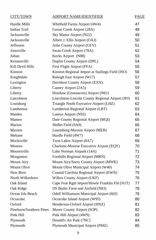
Hurdle Mills Whitfield Farms Airport (4W4) 47
Indian Trail Goose Creek Airport (28A) 48
Jacksonville Sky Manor Airport (N22) 49
Jacksonville Albert J. Ellis Airport (OAJ) 50
Jefferson Ashe County Airport (GEV) 51
Jonesville Swan Creek Airport (78A) 52
Julian Kecks Airport (N88) 53
Kenansville Duplin County Airport (DPL) 54
Kill Devil Hills First Flight Airport (FFA) 55
Kinston Kinston Regional Jetport at Stallings Field (ISO) 56
Knightdale Raleigh East Airport (W17) 57
Lexington Davidson County Airport (EXX) 58
Liberty Causey Airport (2A5) 59
Liberty Hinshaw (Greenacres) Airport (N61) 60
Lincolnton Lincolnton-Lincoln County Regional Airport (IPJ) 61
Louisburg Triangle North Executive Airport (LHZ) 62
Lumberton Lumberton Regional Airport (LBT) 63
Maiden Laneys Airport (N92) 64
Manteo Dare County Regional Airport (MQI) 65
Marion Shiflet Field (9A9) 66
Maxton Laurinburg-Maxton Airport (MEB) 67
Mebane Hurdle Field (4W7) 68
Mocksville Twin Lakes Airport (8A7) 69
Monroe Charlotte-Monroe Executive Airport (EQY) 70
Mooresville Lake Norman Airpark (14A) 71
Morganton Foothills Regional Airport (MRN) 72
Mount Airy Mount Airy/Surry County Airport (MWK) 73
Mount Olive Mount Olive Municipal Airport (W40) 74
New Bern Coastal Carolina Regional Airport (EWN) 75
North Wilkesboro Wilkes County Airport (UKF) 76
Oak Island Cape Fear Rgnl Jetport/Howie Franklin Fld (SUT) 77
Oak Ridge DS Butler Farm and Airfield (N83) 78
Ocean Isle Beach Odell Williamson Municipal Airport (60J) 79
Ocracoke Ocracoke Island Airport (W95) 80
Oxford Henderson-Oxford Airport (HNZ) 81
Pinehurst/Southern Pines Moore County Airport (SOP) 82
Pink Hill Pink Hill Airport (4W9) 83
Plymouth Donald's Air Park (7NC) 84
Plymouth Plymouth Municipal Airport (PMZ) 85
CITY/TOWN AIRPORT NAME/IDENTIFIER PAGE
9

Raeford PK Airpark (5W4) 86
Raleigh Triple W Airport (5W5) 87
Raleigh Raleigh-Durham International Airport (RDU) 88
Reidsville Rockingham County-NC Shiloh Airport (SIF) 89
Reidsville Warf Airport (6A5) 90
Roanoke Rapids Halifax-Northampton Regional Airport (IXA) 91
Rockingham Richmond County Airport (RCZ) 92
Rocky Mount Rocky Mount-Wilson Regional Airport (RWI) 93
Roxboro Person County Airport (TDF) 94
Rutherfordton Rutherford County-Marchman Field (FQD) 95
Salisbury Rowan County Airport (RUQ) 96
Sanford Raleigh Exec. Jetport at Sanford-Lee County (TTA) 97
Shelby Shelby-Cleveland County Regional (EHO) 98
Siler City Siler City Municipal Airport (SCR) 99
Smithfield Johnston Regional Airport (JNX) 100
Spruce Pine Avery County/Morrison Field (7A8) 101
Star Montgomery County Airport (43A) 102
Statesville Statesville Regional Airport (SVH) 103
Sylva Jackson County Airport (24A) 104
Tarboro Tarboro-Edgecombe Airport (ETC) 105
Taylorsville Taylorsville Airport (NC2) 106
Thomasville Hiatt Airport (N97) 107
Wadesboro Anson County Airport (AFP) 108
Wallace Henderson Field (ACZ) 109
Walnut Cove Meadow Brook Field (N63) 110
Washington Warren Field (OCW) 111
Waxhaw JAARS-Townsend Airport (N52) 112
Whiteville Columbus County Municipal Airport (CPC) 113
Williamston Martin County Airport (MCZ) 114
Wilmington Wilmington International Airport (ILM) 115
Wilson Wilson Industrial Air Center (W03) 116
Winston-Salem Smith Reynolds Airport (INT) 117
Winterville South Oaks Aerodrome (05N) 118
Yadkinville Lone Hickory Airport (80C) 119
Yanceyville Caswell Airport (6W4) 120
CITY/TOWN AIRPORT NAME/IDENTIFIER PAGE
10

Contacting NCDOT Division of Aviation
The North Carolina Department of Transportation Division of Aviation
is located at the Raleigh-Durham International Airport.
Please use the addresses and numbers below to contact us.
MAILING ADDRESS
1560 Mail Service Center
Raleigh, NC 27699-1560
PHYSICAL ADDRESS
1050 Meridian Drive
RDU Airport, NC 27623
TELEPHONE NUMBERS (919) 814-0550
Fax: (919) 840-0645
WEBSITE ADDRESS
www.ncdot.gov/aviation/
11

Tri-County Airport - ASJ
Ahoskie 36° 17.85' 77° 10.25'
AWOS/ASOS: 119.075 ATIS:
Clearance: Ground: Tower:
CTAF: 122.80
Communications:
PCL: 122.8 RCO:
Unicom: 122.80 App/Dep: Washington Center 123.85
FBO Telephone Numbers: Services:AVGAS, Jet A, Hours of Operation: Mon-Sat 9 a.m. -Dusk,Tie-Downs, WIFI
Charts:Navaids:
Web SiteElevation: 67' MSL Both Rwys have 4' ditch 120' left & rgt of centerline.Special Notices/Warnings:
Ahoskie
Tri-Air, Inc. (252) 345-0111Airport Number (252) 345-9962
CVI VOR: 144.6-262° Radial at 15.2 NMApproaches: VOR-DME, GPS
Sectional: WashingtonLow Alt Enroute: L-35C,36G
12

Stanly County Airport - VUJ
Albemarle 35° 25.00' 80° 09.05'
AWOS/ASOS: 128.175 ATIS:
Clearance: 128.50 Ground: 121.75 Tower: 126.275
CTAF: 126.20
Communications:
PCL: 126.275 RCO: 128.5
Unicom: 123.00 App/Dep: Charlotte Approach 128.325
FBO Telephone Numbers: Services:AVGAS, Jet A, Hours of Operation: 8 a.m. - 8 p.m.Daily, Tie-Downs, Hangars, Rental Cars, Maintenance,Self Serve AVGAS 24 hrs daily, WIFI
Charts:Navaids:
Web SiteElevation: 609' MSL www.stanlycountyairport.com FBO Hours 8 a.m. - 8 p.m. Daily, Tower Hrs 8am-10pmM-F.Special Notices/Warnings:
Albemarle
Stanly Co. FBO (704) 982-9013Pressley Aviation LLC (980) 272-8359
SDZ VOR: 111.8 - 297° Radial at 30.1 NMVU NDB: 346 - 224° Radial at 5.5 NMApproaches: ILS, NDB, RNAV (GPS)
Sectional: CharlotteLow Alt Enroute: L-25E, 36E
13

Western Carolina Regional - RHP
Andrews 35° 11.71' 83° 51.78'
AWOS/ASOS: 119.675 ATIS:
Clearance: Ground: Tower:
CTAF: 122.80
Communications:
PCL: 122.8 RCO:
Unicom: 122.80 App/Dep: Atlanta Center 134.8
FBO Telephone Numbers: Services:AVGAS, Jet A w/prist, Hours of Operation:8 am - 6 pm, On Call 24 hrs, Tie-Downs, Hangars,Rental Cars, Maintenance, WIFI
Charts:Navaids:
Web SiteElevation: 1698' MSL Twy Unlighted, Rising Terrain, Rwy 08 Right trafficonly.Special Notices/Warnings:
Andrews
Cherokee County (828) 321-5114
HRS VOR: 109.8 - 010° Radial at 15.3 NMApproaches: RNAV(GPS)
Sectional: AtlantaLow Alt Enroute: L-25B
14

Asheboro Regional Airport - HBI
Asheboro 35° 39.27' 79° 53.69'
AWOS/ASOS: 119.275 ATIS:
Clearance: 130.70 Ground: Tower:
CTAF: 122.80
Communications:
PCL: 122.8 RCO: 130.7
Unicom: 122.80 App/Dep: Greensboro Approach 126.6
FBO Telephone Numbers: Services:AVGAS, Jet A, Hours of Operation:Oct. - May: 8 a.m. - Dusk ; June - Sept.: 8 am- 8 pm,Tie-Downs, Maintenance, Hangar Rentals, WIFI
Charts:Navaids:
Web SiteElevation: 673' MSL www.cardinal-air.com Rising Terrain all Quadrants, Rwy 03 has 40-FootDrop-off 400' from thld, Vintage aircraft museum on the field.Special Notices/Warnings:
Asheboro
Cardinal Air (336) 625-6120Flying Leaf Av. Maint. (336) 626-3600 JD Wall Air flt school (336) 215-4893
GSO VOR: 116.2 - 173° Radial at 23.8 NMApproaches: VOR, RNAV(GPS)
Sectional: CharlotteLow Alt Enroute: L-25E, 36F
15

Asheville Regional Airport - AVL
Asheville 35° 26.17' 82° 32.51'
AWOS/ASOS: 120.200 ATIS: 120.2
Clearance: 121.90 Ground: 121.9 Tower: 121.1
CTAF: 121.10
Communications:
PCL: 121.1 RCO:
Unicom: 122.95 App/Dep: 125.8, 124.65, 132.625 (Atlanta Center)
FBO Telephone Numbers: Services:AVGAS, Jet A, 24-Hour Operation, Tie-Downs, RentalCars, Maintenance, Hangars, WIFI
Charts:Navaids:
Web SiteElevation: 2165' MSL www.landmarkaviation.com/fbo/avl See AFD for Class C Airspace Schedule,Communications Unavailable Below 6,000 Feet when Approach Control Closed. Rwy34 Right Traffic when ATCT is CLSD.
Special Notices/Warnings:
Asheville
Landmark Aviation (828) 687-7110 WNC Aviation Flt school (828) 650-6540Belle Aircraft MaintenanceLLC
(828) 684-9191
SUG VOR: 112.2 - 280° Radial at 13.5 NMBRA NDB: 379 - 344 ° Radial at 10.4NMApproaches: ILS, RNAV(GPS), ASR
Sectional: AtlantaLow Alt Enroute: L-25C
16
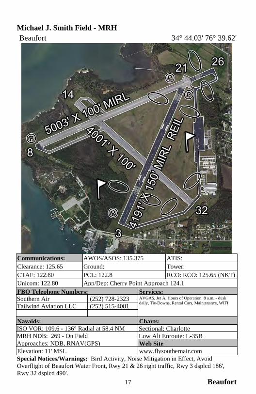
Michael J. Smith Field - MRH
Beaufort 34° 44.03' 76° 39.62'
AWOS/ASOS: 135.375 ATIS:
Clearance: 125.65 Ground: Tower:
CTAF: 122.80
Communications:
PCL: 122.8 RCO: RCO: 125.65 (NKT)
Unicom: 122.80 App/Dep: Cherry Point Approach 124.1
FBO Telephone Numbers: Services:AVGAS, Jet A, Hours of Operation: 8 a.m. - duskdaily, Tie-Downs, Rental Cars, Maintenance, WIFI
Charts:Navaids:
Web SiteElevation: 11' MSL www.flysouthernair.com Bird Activity, Noise Mitigation in Effect, AvoidOverflight of Beaufort Water Front, Rwy 21 & 26 right traffic, Rwy 3 dsplcd 186',Rwy 32 dsplcd 490'.
Special Notices/Warnings:
Beaufort
Southern Air (252) 728-2323Tailwind Aviation LLC (252) 515-4081
ISO VOR: 109.6 - 136° Radial at 58.4 NMMRH NDB: 269 - On FieldApproaches: NDB, RNAV(GPS)
Sectional: CharlotteLow Alt Enroute: L-35B
17

Bladenboro Airport - 3W6
Bladenboro 34° 32.57' 78° 46.69'
AWOS/ASOS: ATIS:
Clearance: Ground: Tower:
CTAF: 122.90
Communications:
PCL: RCO:
Unicom: 122.90 App/Dep: Fayetteville 133.0
FBO Telephone Numbers: Services:No Fuel Available, Hours of Operation: Unattended
Charts:Navaids:
Web SiteElevation: 116' MSL Rwy 02-20 has small depressions on rwy ends & apron.Special Notices/Warnings:
Bladenboro
Airport Number (910) 863-3149
FAY VOR: 108.8 - 173° Radial at 26.5 NM Sectional: Charlotte:Low Alt Enroute:
18

Burlington-Alamance Regional Airport - BUY
Burlington 36° 02.98' 79° 28.38'
AWOS/ASOS: 135.325 ATIS:
Clearance: 120.25 Ground: Tower:
CTAF: 122.97
Communications:
PCL: 122.975 RCO: 120.25 (GCO)
Unicom: 122.97 App/Dep: Greensboro Approach 126.6
FBO Telephone Numbers: Services:AVGAS, Jet A, Hours of Operation: M-F 7:00 am -7:30 pm, Sat & Sun 8:00 am - 6:00 pm, Tie-Downs,Rental Cars, Maintenance, WIFI
Charts:Navaids:
Web SiteElevation: 616' MSL www.skysouthaviation.com High Intensity Lights - Change Intensity - CTAFSpecial Notices/Warnings:
Burlington
Sky South Aviation (336) 226-3330Burlington Aviation (336) 229-9543
LIB VOR: 113.0 - 028° Radial at 15.8 NMHB NDB: 361 - 060° Radial at 6.9 NMApp:ILS,VOR-DME,NDB,RNAV(GPS)
Sectional: CincinnatiLow Alt Enroute: L-25E, 36F
19

Horace Williams Airport - IGX
Chapel Hill 35° 56.10' 79° 03.96'
AWOS/ASOS: 134.575 ATIS:
Clearance: 126.50 Ground: Tower:
CTAF: 123.00
Communications:
PCL: 123 RCO: 126.5 (RDU)
Unicom: 123.00 App/Dep: Raleigh Approach 132.35
FBO Telephone Numbers: Services:AVGAS, Jet A, Hours of Operation: M-S 8 am-9 pm,Tie-Downs, Rental Cars.
Charts:Navaids:
Web SiteElevation: 512' MSL www.airport.unc.edu Rwy 27 right traffic. Rwy 27 dsplcd 730'. Manyrestrictions. Refer to AFD and call airport manager (919) 962-1337.Special Notices/Warnings:
Chapel Hill
Airport Number (919) 962-1337
RDU VOR: 117.2 - 289° Radial at 14.2 NMApproaches: VOR-DME, RNAV(GPS)
Sectional: CharlotteLow Alt Enroute: L-36F
20

Charlotte/Douglas International Airport - CLT
Charlotte 35° 12.82' 80° 56.94'
AWOS/ASOS: ATIS: 121.15-A,132.1-D
Clearance: 127.15 Ground: 121.9(E)/ 121.8(W) Tower: 118.1/126.4
CTAF:
Communications:
PCL: RCO: 122.4
Unicom: 129.40 App/Dep: Multiple (See AF/D)
FBO Telephone Numbers: Services:AVGAS, Jet A, 24-Hour Operation, Tie-Downs, RentalCars, Maintenance, WIFI
Charts:Navaids:
Web SiteElevation: 748' MSL www. wilsonair.com Class B Airspace, Bird Activity, Noise AbatementProcedures in Effect.Special Notices/Warnings:
Charlotte
Wilson Air Center (704) 359-0440
CLT VOR: 115.0 - 010° Radial at 1.4 NM
Approaches: ILS, RNAV(GPS & RNP)
Sectional: CharlotteLow Alt Enroute: L-25D, 36E
21
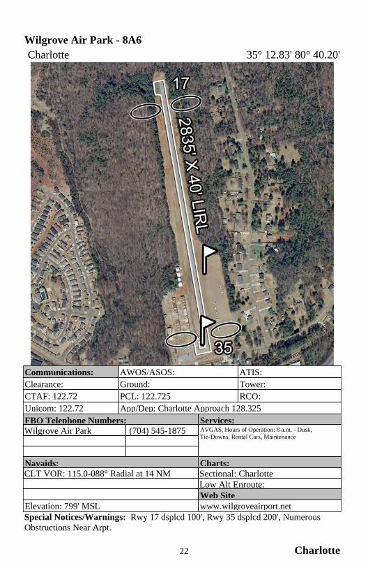
Wilgrove Air Park - 8A6
Charlotte 35° 12.83' 80° 40.20'
AWOS/ASOS: ATIS:
Clearance: Ground: Tower:
CTAF: 122.72
Communications:
PCL: 122.725 RCO:
Unicom: 122.72 App/Dep: Charlotte Approach 128.325
FBO Telephone Numbers: Services:AVGAS, Hours of Operation: 8 a.m. - Dusk,Tie-Downs, Rental Cars, Maintenance
Charts:Navaids:
Web SiteElevation: 799' MSL www.wilgroveairport.net Rwy 17 dsplcd 100', Rwy 35 dsplcd 200', NumerousObstructions Near Arpt.Special Notices/Warnings:
Charlotte
Wilgrove Air Park (704) 545-1875
CLT VOR: 115.0-088° Radial at 14 NM Sectional: CharlotteLow Alt Enroute:
22

Clinton-Sampson County Airport - CTZ
Clinton 34° 58.50' 78° 21.94'
AWOS/ASOS: 119.125 ATIS:
Clearance: Ground: Tower:
CTAF: 122.80
Communications:
PCL: 122.8 RCO:
Unicom: 122.80 App/Dep: Fayetteville Approach 133.0
FBO Telephone Numbers: Services:AVGAS, Jet A, Hours of Operation: M-S 8:30am. -dusk, Sun 1pm - 6pm, Tie-Downs, Rental Cars,Maintenance, WIFI, Fuel available afer hours uponrequest
Charts:Navaids:
Web SiteElevation: 144' MSL LOC unusable inside 1.2 NM from thld and byd 25º rgtof course, Rwy Ends Have 40' drop-offs.Special Notices/Warnings:
Clinton
Clinton Flying Service (910) 592-3295After Hrs. Fuel (910) 590-9100
FAY VOR: 108.8 - 095° Radial at 25.1 NMCTZ NDB: 412 - On FieldApproaches: LOC, VOR-DME, RNAV(GPS)
Sectional: CharlotteLow Alt Enroute: L-35B, 36F
23

Concord Regional Airport - JQF
Concord 35° 23.27' 80° 42.55'
AWOS/ASOS: 133.675 ATIS: 133.675
Clearance: 118.55 Ground: 121.85 Tower: 134.65
CTAF: 134.65
Communications:
PCL: 134.65 RCO: 127.25 (CLT)
Unicom: 122.95 App/Dep: Charlotte Approach 128.32
FBO Telephone Numbers: Services:AVGAS, Jet A, 24-Hour Operation, Tie-Downs,Rental Cars, Maintenance, WIFI
Charts:Navaids:
Web SiteElevation: 705' MSL www.concordairportnc.com Class D Airspace in Effect 7 a.m. - 11 p.m.; Other timesClass G, 24-hr cust. service desk (704) 793-9000. Rwy 20 dsplcd 650'Special Notices/Warnings:
Concord
Paramount Flight Services (704) 784-1295Spitfire Aviation (704) 784-3591Concord Regional Airport (704) 920-5900
CLT VOR: 115.0 - 050° Radial at 16.8 NMApproaches: ILS, LOC, RNAV(GPS)
Sectional: CharlotteLow Alt Enroute: L-25D, 36E
24

Currituck County Regional Airport - ONX
Currituck 36° 24.00' 76° 00.93'
AWOS/ASOS: 119.775 ATIS:
Clearance: Ground: Tower:
CTAF: 122.90
Communications:
PCL: 122.9 RCO:
Unicom: 122.90 App/Dep: Oceana 123.9
FBO Telephone Numbers: Services:AVGAS, MOGAS, Jet A, Hours of Operation: 8 a.m. -4 p.m., 24 Hour Self Serve Fuel, Tie-Downs,Maintenance
Charts:Navaids:
Web SiteElevation: 17' MSL www.fly2OBX.com Deer & Bird Activity.Special Notices/Warnings:
Currituck
Airport Manager (252) 453-2876
ECG VOR: 112.5 - 049° Radial at 11.5 NM
Approaches: VOR-DME, RNAV(GPS)
Sectional: WashingtonLow Alt Enroute: L-35D
25

Northeastern Regional Airport - EDE
Edenton 36° 01.66' 76° 34.03'
AWOS/ASOS: 121.125 ATIS:
Clearance: Ground: Tower:
CTAF: 123.00
Communications:
PCL: 123.00 RCO:
Unicom: 123.00 App/Dep: Washington Approach 123.85
FBO Telephone Numbers: Services:AVGAS, Jet A, Hours of Operation: 8 a.m. - 5 p.m. ,24 Hour Self Service Fuel, Tie-Downs, Rental Cars,Maintenance, WIFI
Charts:Navaids:
Web SiteElevation: 20' MSL Bird and Deer Activity on & invof arpt.Special Notices/Warnings:
Edenton
Airport Number (252) 482-4664Fax (252) 482-4187
CVI VOR: 114.6 - 153° Radial at 25.4 NMEDE NDB: 265 - On FieldApproaches: ILS, LOC, RNAV(GPS)
Sectional: WashingtonLow Alt Enroute: L-35C
26

Elizabeth City CGAS/Regional Airport - ECG
Elizabeth City 36° 15.63' 76° 10.47'
AWOS/ASOS: 124.375 ATIS:
Clearance: Ground: 121.9 Tower: 120.5
CTAF: 120.50
Communications:
PCL: 120.5 RCO: 122.2
Unicom: 122.90 App/Dep: Norfolk 119.55
FBO Telephone Numbers: Services:AVGAS, Jet A, Hours of Operation: M-F 8 am - 9 pm,Sat- Sun. & Holidays 8 am - 5 pm, Tie-Downs, RentalCars, Maintenance
Charts:Navaids:
Web SiteElevation: 11' MSL www.ECGAIRPORT.com Joint Use USCG Facility, Noise Abatement Procedures,Tethered Balloon Ops. & Blimp Training/Ops. 3 miles SE, Rwy 1 dsplcd 299', Rwy 1right traffic
Special Notices/Warnings:
Elizabeth City
Main Airport Number (252) 334-6534After Hours Fuel (252) 334-4224
ECG VOR: 112.5 - On FieldLLW NDB: 254 - 101° Radial at 6 NMApp:ILS,VOR-DME,RNAV(GPS), LOC, NDB
Sectional: WashingtonLow Alt Enroute: L-35D
27

Curtis L. Brown, Jr. Field - EYF
Elizabethtown 34° 36.11' 78° 34.76'
AWOS/ASOS: 119.475 ATIS:
Clearance: Ground: Tower:
CTAF: 122.80
Communications:
PCL: 122.8 RCO: 121.725 (GCO)
Unicom: 122.80 App/Dep: Fayetteville Approach 133.0
FBO Telephone Numbers: Services:AVGAS, Jet A, Hours of Operation: 8:00 a.m. - Dusk,Tie-Downs, WIFI
Charts:Navaids:
Web SiteElevation: 132' MSL www.elizabethtownnc.org Deer and Bird Activity, Low Level Military Activityinvof arpt.Special Notices/Warnings:
Elizabethtown
Taylor Aviation (910) 862-4522Fax (910) 862-3299After Hours(910) 247-6000 (910) 862-8928
FAY VOR: 108.8 - 151° Radial at 27.2 NMTGQ NDB: 398 - 332° Radial at 5.4 NMApproaches: VOR-DME, RNAV(GPS)
Sectional: CharlotteLow Alt Enroute: L-35A, 36F
28

Elkin Municipal Airport - ZEF
Elkin 36° 16.80' 80° 47.16'
AWOS/ASOS: ATIS:
Clearance: Ground: Tower:
CTAF: 123.05
Communications:
PCL: 123.05 RCO:
Unicom: 123.05 App/Dep: Atlanta Center 125.15
FBO Telephone Numbers: Services:AVGAS, Jet A, Hours of Operation: 9 a.m. to 5 p.m.,24-hr self svc fuel available. Tie-Downs, Rental Cars,Maintenance, WIFI
Charts:Navaids:
Web SiteElevation: 1067' MSL Steep Terrain within 75 Feet of Rwy, Deer Activity.Special Notices/Warnings:
Elkin
Yadkin Valley Aviation (336) 366-3433
BZM VOR: 110.8 - 048° Radial at 33.1 NMZEF NDB: 326 - 246° Radial at 3.4 NMApproaches: NDB, RNAV(GPS)
Sectional: CincinnatiLow Alt Enroute: L-25D
29

Hyde County Airport - 7W6
Englehard 35° 33.72' 75° 57.34'
AWOS/ASOS: ATIS:
Clearance: Ground: Tower:
CTAF: 122.70
Communications:
PCL: 122.7 RCO:
Unicom: 122.70 App/Dep: Washington Ctr. 124.72
FBO Telephone Numbers: Services:AVGAS 100LL 24 hr. Self Serve, Hours of Operation:M-Th 1 p.m.- 4 p.m.
Charts:Navaids:
Web SiteElevation: 6' MSL www.hydecounty.org High Speed & Low Level Military Activity invof arpt,Right Traffic Pattern for Rwy 11, Wildlife hazardsSpecial Notices/Warnings:
Englehard
Airport (252) 943-4113
ISO VOR: 109.6 - 086° Radial at 79.4 NM Sectional: CharlotteLow Alt Enroute: L-35C
30
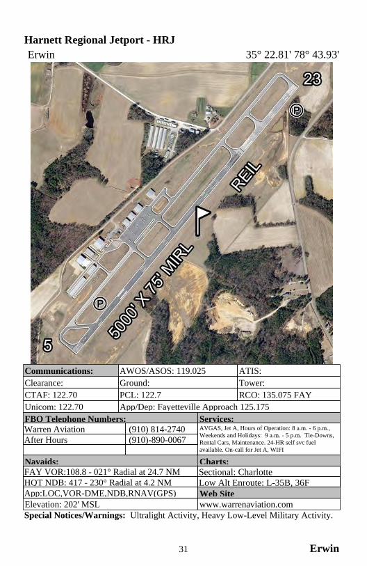
Harnett Regional Jetport - HRJ
Erwin 35° 22.81' 78° 43.93'
AWOS/ASOS: 119.025 ATIS:
Clearance: Ground: Tower:
CTAF: 122.70
Communications:
PCL: 122.7 RCO: 135.075 FAY
Unicom: 122.70 App/Dep: Fayetteville Approach 125.175
FBO Telephone Numbers: Services:AVGAS, Jet A, Hours of Operation: 8 a.m. - 6 p.m.,Weekends and Holidays: 9 a.m. - 5 p.m. Tie-Downs,Rental Cars, Maintenance. 24-HR self svc fuelavailable. On-call for Jet A, WIFI
Charts:Navaids:
Web SiteElevation: 202' MSL www.warrenaviation.com Ultralight Activity, Heavy Low-Level Military Activity.Special Notices/Warnings:
Erwin
Warren Aviation (910) 814-2740After Hours (910)-890-0067
FAY VOR:108.8 - 021° Radial at 24.7 NMHQT NDB: 417 - 230° Radial at 4.2 NMApp:LOC,VOR-DME,NDB,RNAV(GPS)
Sectional: CharlotteLow Alt Enroute: L-35B, 36F
31
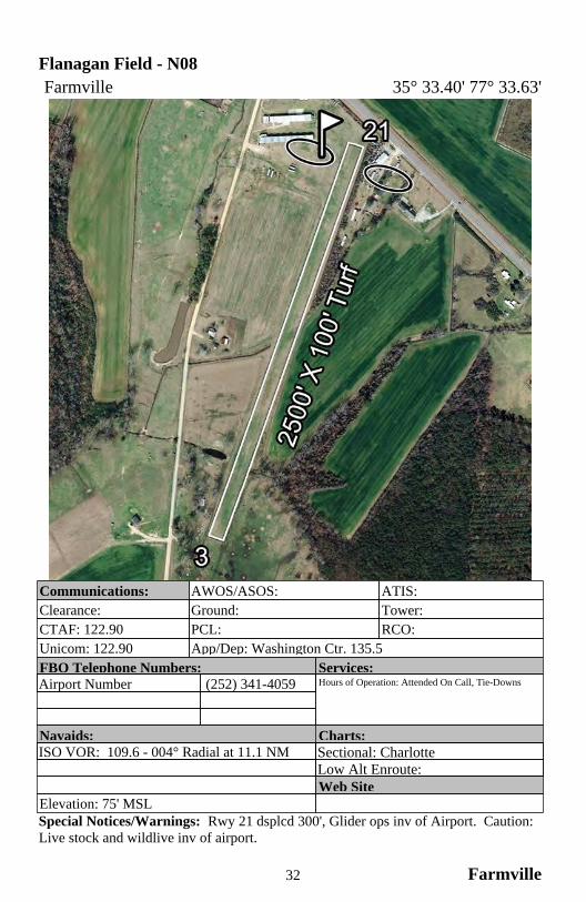
Flanagan Field - N08
Farmville 35° 33.40' 77° 33.63'
AWOS/ASOS: ATIS:
Clearance: Ground: Tower:
CTAF: 122.90
Communications:
PCL: RCO:
Unicom: 122.90 App/Dep: Washington Ctr. 135.5
FBO Telephone Numbers: Services:Hours of Operation: Attended On Call, Tie-Downs
Charts:Navaids:
Web SiteElevation: 75' MSL Rwy 21 dsplcd 300', Glider ops inv of Airport. Caution:Live stock and wildlive inv of airport.Special Notices/Warnings:
Farmville
Airport Number (252) 341-4059
ISO VOR: 109.6 - 004° Radial at 11.1 NM Sectional: CharlotteLow Alt Enroute:
32

Fayetteville Regional/Grannis Field - FAY
Fayetteville 34° 59.47' 78° 52.82'
AWOS/ASOS: 121.25 ATIS: 121.25
Clearance: Ground: 121.7 Tower: 118.3
CTAF:
Communications:
PCL: RCO: 122.1(R)/108.8(T)
Unicom: 122.95 App/Dep: 133.0, 127.8, 125.175 (See AFD)
FBO Telephone Numbers: Services:AVGAS, Jet A, Hours of Operation: 6 a.m. - 10 p.m.,Tie-Downs, Rental Cars, Maintenance, WIFI
Charts:Navaids:
Web SiteElevation: 189' MSL www.landmarkaviation.com/fbo/fay Class C Service Continuously. Rwy 22 displaced 303',Rwy 4 displaced 598'Special Notices/Warnings:
Fayetteville
Landmark Aviation (910) 321-7540Roger's Aircraft Svcs (910) 323-1245Powell Avionics (910) 484-0236
FAY VOR: 108.8 - On Field
Approaches: ILS,LOC-BC,VOR,RNAV(GPS)
Sectional: CharlotteLow Alt Enroute: L-35A, 36F
33

Grays Creek Airport - 2GC
Fayetteville 34° 53.62' 78° 50.61'
AWOS/ASOS: ATIS:
Clearance: Ground: Tower:
CTAF: 122.90
Communications:
PCL: RCO:
Unicom: 122.90 App/Dep: Fayetteville 133.0
FBO Telephone Numbers: Services:AVGAS, Hours of Operation 8 a.m. - 5 p.m.,Weekends by appt. call (910) 286-3435, For Rwylights call (910) 483-4114.Tie-Downs, Maintenance
Charts:Navaids:
Web SiteElevation: 160' MSL www.grayscreekairport.com Just Underneath Fayetteville Class C Airspace, Rwy 35dsplcd 350' (trees & pwr line), Exit/Enter Rwy from South End.Special Notices/Warnings:
Fayetteville
Cape Fear Aviation (910) 483-4114CATS computer testing (910) 286-3435Flight Training (910) 223-0567
FAY VOR: 108.8 - 168° Radial at 5.7 NM Sectional: CharlotteLow Alt Enroute: L-35A, 36F
34

Macon County Airport - 1A5
Franklin 35° 13.34' 83° 25.20'
AWOS/ASOS: 118.225 ATIS:
Clearance: Ground: Tower:
CTAF: 123.05
Communications:
PCL: 123.05 RCO:
Unicom: 123.05 App/Dep: Atlanta Ctr. 134.8
FBO Telephone Numbers: Services:AVGAS, Jet A, Hours of Operation: 8 a.m. - Dusk,Tie-Downs, Maintenance,WIFI
Charts:Navaids:
Web SiteElevation: 2034' MSL www.franklin-chamber.com/airport Rapidly Rising Terrain All Quadrants, Right TrafficPattern for Rwy 25, Arpt Beacon Located 3/4 Mile SE of arpt.Special Notices/Warnings:
Franklin
Franklin Aviation (828) 524-5529Fax (828) 369-5889
HRS VOR: 109.8 - 055° Radial at 29.6 NM
Approaches: RNAV(GPS)-A
Sectional: AtlantaLow Alt Enroute: L-25B
35

Gastonia Municipal Airport - AKH
Gastonia 35° 12.16' 81° 08.99'
AWOS/ASOS: 135.725 ATIS:
Clearance: 127.20 Ground: Tower:
CTAF: 123.00
Communications:
PCL: 123.00 RCO: 127.2
Unicom: 123.00 App/Dep: Charlotte Approach 134.75
FBO Telephone Numbers: Services:AVGAS, Jet A, Hours of Operation: 8 a.m. - 5 p.m.M-F, 9 a.m. - 5 p.m. Sat, 11:00 am - 5 pm Sun,Tie-Downs, Rental Cars, Maintenance, WIFI
Charts:Navaids:
Web SiteElevation: 798' MSL www.cityofgastonia.com Caution: Just Outside Charlotte Class B Airspace (SeeAFD), Noise Abatement Procedures. Rwy 21 displaced 90'.Special Notices/Warnings:
Gastonia
Fly Carolina Aviation (704) 864-4363After Hours Service (704) 201-1500
CLT VOR: 115.0 - 279° Radial at 9.8 NMGHJ NDB: 260 - On FieldApproaches: NDB, RNAV(GPS)
Sectional: CharlotteLow Alt Enroute: L-25D, 36E
36

Wayne Executive Jetport - GWW
Goldsboro 35° 27.63' 77° 57.90'
AWOS/ASOS: 118.975 ATIS:
Clearance: Ground: Tower:
CTAF: 122.70
Communications:
PCL: 122.7 RCO:
Unicom: 122.70 App/Dep: 123.7, 127.3, 119.7
FBO Telephone Numbers: Services:AVGAS, Jet A, Hours of Operation:Nov.-Mar.: 8a.m. - 6 p.m. Apr.-Oct.: 8a.m. - 8p.m.Tie-Downs, Maintenance, WIFI
Charts:Navaids:
Web SiteElevation: 133' MSL www.waynegov.com Ultralights, gliders, & parachute activities require PPR(call 919-734-7630), Military Traffic and Activity near arpt. For Service After Hourscall (919) 581-7554
Special Notices/Warnings:
Goldsboro
Airport Number (919) 734-7630Wayne Aviation (919) 731-7412Wayne Air (919) 739-0095
ISO VOR: 109.6 - 290° Radial at 20.6 NMApproaches: ILS, VOR, RNAV(GPS)
Sectional: CharlotteLow Alt Enroute: L-35B, 36F
37

Piedmont Triad International Airport - GSO
Greensboro 36° 06.08' 79° 56.47'
AWOS/ASOS: 128.55 ATIS: 128.55
Clearance: 121.75 Ground: 121.9 Tower: 119.1
CTAF: 119.10
Communications:
PCL: RCO: 122.1R 116.2T
Unicom: 122.95 App/Dep: 124.35 (250° - 049°) 126.6 (050° - 249°) 118.5
FBO Telephone Numbers: Services:AVGAS, Jet A, 24-Hour Operation, Tie-Downs,Rental Cars, Maintenance, WIFI
Charts:Navaids:
Web SiteElevation: 926' MSL www.flyfrompti.com LAHSO Operations (See AFD).Special Notices/Warnings:
Greensboro
Landmark Aviation (336) 668-0481
GSO VOR: 116.2 - 030° Radial at 3.7 NMGS NDB: 254 - 139° Radial at 6 NMApproaches: ILS,VOR-DME,RNAV(GPS)
Sectional: CincinnatiLow Alt Enroute: L-25E, 36F
38

Air Harbor - W88
Greensboro 36° 10.42' 79° 48.18'
AWOS/ASOS: ATIS:
Clearance: Ground: Tower:
CTAF: 122.80
Communications:
PCL: RCO:
Unicom: 122.80 App/Dep: Greensboro 126.6
FBO Telephone Numbers: Services:AVGAS, Hours of Operation: Noon- Dusk,Tie-Downs, Maintenance
Charts:Navaids:
Web SiteElevation: 822' MSL Rwy 09 has 60' drop-off 220' from thld.Special Notices/Warnings:
Greensboro
Murphy Aviation (336) 288-4275After Hrs. Emergency (336) 669-5462
GSO VOR: 116.2 - 053° Radial at 11.5 NM Sectional: CincinnatiLow Alt Enroute:
39
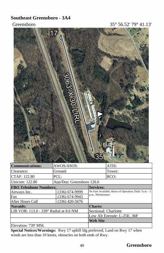
Southeast Greensboro - 3A4
Greensboro 35° 56.52' 79° 41.13'
AWOS/ASOS: ATIS:
Clearance: Ground: Tower:
CTAF: 122.80
Communications:
PCL: RCO:
Unicom: 122.80 App/Dep: Greensboro 126.6
FBO Telephone Numbers: Services:No Fuel Available, Hours of Operation: Daily 7a.m. - 5p.m., Maintenance
Charts:Navaids:
Web SiteElevation: 739' MSL Rwy 17 uphill ldg preferred, Land on Rwy 17 whenwinds are less than 10 knots, obstacles on both ends of Rwy.Special Notices/Warnings:
Greensboro
Airways Inc. (336) 674-9999Fax (336) 674-9943After Hours Call (336) 420-5676
LIB VOR: 113.0 - 339° Radial at 8.6 NM Sectional: CharlotteLow Alt Enroute: L-25E, 36F
40

Pitt-Greenville Airport - PGV
Greenville 35° 38.12' 77° 23.12'
AWOS/ASOS: 128.425 ATIS:
Clearance: 122.35 Ground: Tower:
CTAF: 122.80
Communications:
PCL: 122.8 RCO: 122.35-RDU FSS
Unicom: 122.80 App/Dep: Washington Center 135.5
FBO Telephone Numbers: Services:AVGAS, JetA, Hours of Operation: 5:30 a.m. - 11:30p.m., Tie-Downs, Rental Cars, Maintenance, WIFI
Charts:Navaids:
Web SiteElevation: 26' MSL www.flypgv.com Hospital Helicopter Operations 1.5 NM Southwest of theAirport, Rwy 20 dsplcd 348'.Special Notices/Warnings:
Greenville
Dillon's Aviation (252) 757-1841Airport Number (FUEL) (252) 902-2026Vann Aero Services (252) 916-2905
TYI VOR: 117.8 - 148° Radial at 25.7 NMAQE NDB: 230 - 198° Radial at 4.3 NMApproaches: ILS,LOC,RNAV(GPS)
Sectional: CharlotteLow Alt Enroute: L-35C
41

Billy Mitchell Airport - HSE
Hatteras 35° 13.97' 75° 37.07'
AWOS/ASOS: 118.375 ATIS:
Clearance: Ground: Tower:
CTAF: 122.90
Communications:
PCL: No Lights RCO: 122.3 Raleigh FSS
Unicom: 122.90 App/Dep: Cherry Point 119.75
FBO Telephone Numbers: Services:No Fuel available, Hours of Operation: Unattended,Tie-Downs
Charts:Navaids:
Web SiteElevation: 16' MSL wwwouterbankscom/billy-mitchel- Arpt closed 30 Min. after SS until 30 Min. before SR,Heavy seagull activity, All night operations prohibited, High Speed Mil Acft invofarpt.
Special Notices/Warnings:
Hatteras
NCDOT Aviation (Raleigh) (919) 814-0550
ECG VOR: 112.5 - 163° Radial at 67.2 NM
Approaches: RNAV(GPS)
Sectional: CharlotteLow Alt Enroute: L-35C
42

Hendersonville Airport - 0A7
Hendersonville 35° 18.46' 82° 25.99'
AWOS/ASOS: ATIS:
Clearance: Ground: Tower:
CTAF: 123.00
Communications:
PCL: 123.0 RCO:
Unicom: 123.00 App/Dep: Asheville 124.65
FBO Telephone Numbers: Services:AVGAS, Hours of Operation: 8:30 a.m. - 5:30 p.m.,Tie-Downs, Maintenance, WIFI
Charts:Navaids:
Web SiteElevation: 2084' MSL www.hendersonvilleairport.com Rwy 15 dsplcd 270'. Rwy 33 dsplcd 325'. Trees androads near runways, Vintage aircraft museum on the field.Special Notices/Warnings:
Hendersonville
Aerolina, Inc. (828) 693-1897After Hrs. Service (828) 693-1897
SUG VOR: 112.2 - 236° Radial at 10 NM Sectional: AtlantaLow Alt Enroute: L-25C
43
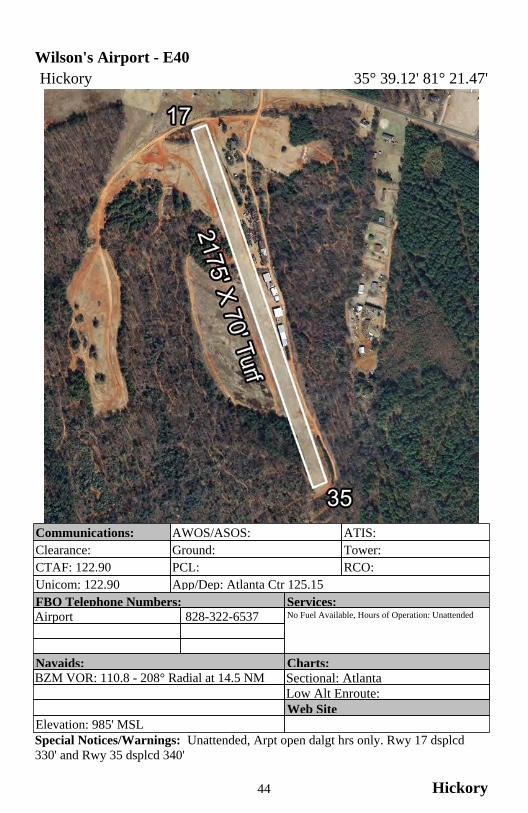
Wilson's Airport - E40
Hickory 35° 39.12' 81° 21.47'
AWOS/ASOS: ATIS:
Clearance: Ground: Tower:
CTAF: 122.90
Communications:
PCL: RCO:
Unicom: 122.90 App/Dep: Atlanta Ctr 125.15
FBO Telephone Numbers: Services:No Fuel Available, Hours of Operation: Unattended
Charts:Navaids:
Web SiteElevation: 985' MSL Unattended, Arpt open dalgt hrs only. Rwy 17 dsplcd330' and Rwy 35 dsplcd 340'Special Notices/Warnings:
Hickory
Airport 828-322-6537
BZM VOR: 110.8 - 208° Radial at 14.5 NM Sectional: AtlantaLow Alt Enroute:
44

Hickory Regional Airport - HKY
Hickory 35° 44.47' 81° 23.37'
AWOS/ASOS: 118.325 ATIS:
Clearance: 121.70 Ground: 121.7 Tower: 128.15
CTAF: 128.15
Communications:
PCL: 128.15 RCO: 124.25
Unicom: App/Dep: Atlanta Center 125.15
FBO Telephone Numbers: Services:AVGAS, Jet A, self-serve 24 hrs, Attended: Daily 7am- 7 pm.Tie-Downs, Rental Cars, Maintenance,Restaurant (828) 324-7800, Museum(www.hickoryaviationmuseum.org), WIFI
Charts:Navaids:
Web SiteElevation: 1190' MSL www.hickorync.gov Rwy 19 Takeoffs Prohibited when Tower closed,clearance 124.25 when tower closed,Special Notices/Warnings:
Hickory
Airport Manager (828) 323-7408FBO (828) 327-0147After Hours (828) 514-5638
BZM VOR: 110.8 - 230° Radial at 10.6 NMHK NDB: 332 - 243° Radial at 4.9 NMApp: ILS,LOC,VOR/DME, RNAV(GPS)
Sectional: CharlotteLow Alt Enroute: L-25D
45

Holly Ridge/Topsail Island Airport - N21
Holly Ridge 34° 29.46' 77° 31.86'
AWOS/ASOS: ATIS:
Clearance: Ground: Tower:
CTAF: 122.90
Communications:
PCL: RCO:
Unicom: 122.90 App/Dep: Wilmington 135.75
FBO Telephone Numbers: Services:No Fuel Available, Hours of Operation: AttendedIrregularly
Charts:Navaids:
Web SiteElevation: 40' MSL Deer Activity on & invof arpt, Rwy 14 dsplcd 925', Rwy32 dsplcd 600'. 2000' available for night ops, (see AFM).Special Notices/Warnings:
Holly Ridge
Airport (910) 329-0041
ILM VOR: 117.0 - 072° Radial at 19 NM Sectional: CharlotteLow Alt Enroute:
46
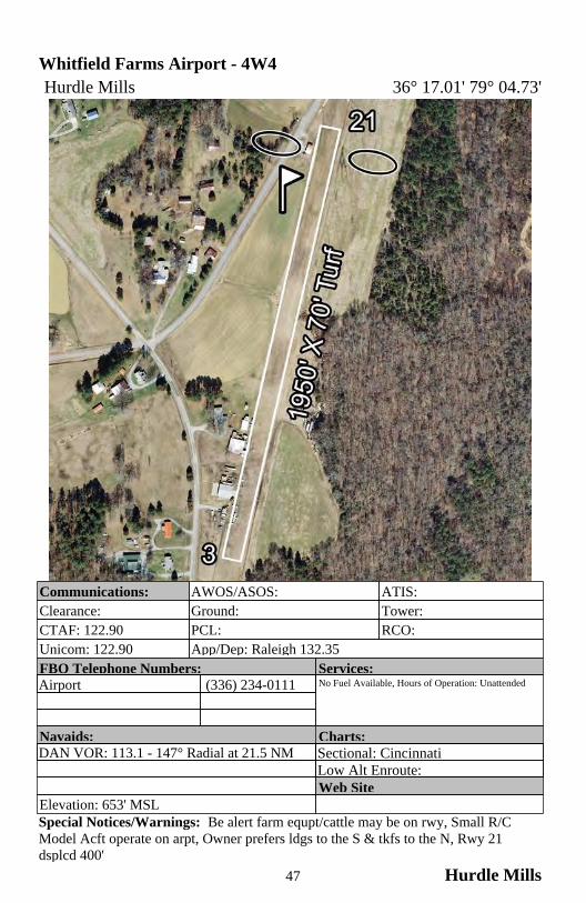
Whitfield Farms Airport - 4W4
Hurdle Mills 36° 17.01' 79° 04.73'
AWOS/ASOS: ATIS:
Clearance: Ground: Tower:
CTAF: 122.90
Communications:
PCL: RCO:
Unicom: 122.90 App/Dep: Raleigh 132.35
FBO Telephone Numbers: Services:No Fuel Available, Hours of Operation: Unattended
Charts:Navaids:
Web SiteElevation: 653' MSL Be alert farm equpt/cattle may be on rwy, Small R/CModel Acft operate on arpt, Owner prefers ldgs to the S & tkfs to the N, Rwy 21dsplcd 400'
Special Notices/Warnings:
Hurdle Mills
Airport (336) 234-0111
DAN VOR: 113.1 - 147° Radial at 21.5 NM Sectional: CincinnatiLow Alt Enroute:
47

Goose Creek Airport - 28A
Indian Trail 35° 07.26' 80° 35.24'
AWOS/ASOS: ATIS:
Clearance: Ground: Tower:
CTAF: 123.00
Communications:
PCL: RCO:
Unicom: 123.00 App/Dep: Charlotte 120.05
FBO Telephone Numbers: Services:AVGAS, MOGAS, Attended Irregularly, Tie-Downs,Maintenance
Charts:Navaids:
Web SiteElevation: 565' MSL www.goosecreekairport.com Bird and Wildlife Activity, Caution Farm Equipment &Ultralights, Rwy 04-22 NSTD LIRL, Rwy 04 dsplcd 130', Night Landings on Rwy 04not authorized, Refer to AFD for traffic pattern info.
Special Notices/Warnings:
Indian Trail
Airport Number (704) 614-3084
CLT VOR: 115.0 - 108° Radial at 18.5 NM Sectional: CharlotteLow Alt Enroute:
48

Sky Manor Airport - N22
Jacksonville 34° 43.01' 77° 35.53'
AWOS/ASOS: ATIS:
Clearance: Ground: Tower:
CTAF: 122.90
Communications:
PCL: RCO:
Unicom: 122.90 App/Dep: Wilmington 135.75
FBO Telephone Numbers: Services:AVGAS, Hours of Operation: Unattended
Charts:Navaids:
Web SiteElevation: 60' MSL Deer Activity invof arpt, Standing water on rwy afterrain; west half of rwy soft when wet. Rwy 8 Threshold Displaced 595'Special Notices/Warnings:
Jacksonville
Airport Number (910) 455-6241After hours (910) 455-1755
ILM VOR: 117.0 - 039° Radial at 26.0 NM Sectional: CharlotteLow Alt Enroute:
49

Albert J. Ellis Airport - OAJ
Jacksonville 34° 49.75' 77° 36.73'
AWOS/ASOS: 124.475 ATIS:
Clearance: 121.40 Ground: Tower:
CTAF: 123.00
Communications:
PCL: 123.0 RCO:
Unicom: 123.00 App/Dep: ILM 135.75, or Wash Cntr 124.02 when Dep inop
FBO Telephone Numbers: Services:AVGAS, Jet A, Hours of Operation: 8 a.m. - 8 p.m.,Tie-Downs, Rental Cars, Maintenance, WIFI
Charts:Navaids:
Web SiteElevation: 93' MSL www.flyoaj.com Deer & Bird Activity.Special Notices/Warnings:
Jacksonville
Airport Main Number (910) 324-1100Jacksonville Flying Srvc. (910) 324-2500After Hrs. Fuel (910) 382-4524
CRE VOR: 117.6 - 045° Radial at 82.2 NMOA NDB: 261 - 052° Radial at 6.6 NMApproaches: ILS,LOC,NDB, RNAV(GPS)
Sectional: CharlotteLow Alt Enroute: L-35B
50

Ashe County Airport - GEV
Jefferson 36° 25.95' 81° 25.18'
AWOS/ASOS: 120.675 ATIS:
Clearance: Ground: Tower:
CTAF: 122.80
Communications:
PCL: 122.8 RCO: 135.075
Unicom: 122.80 App/Dep: Atlanta Center 125.15
FBO Telephone Numbers: Services:AVGAS, Jet A, Hours of Operation: 9 a.m. - 5 p.m.,Tie-Downs, Maintenance , WIFI
Charts:Navaids:
Web SiteElevation: 3178' MSL www.ashencedc.com Rising terrain all quadrants, Rwy 28 VASI is obstructedby mtns, Rwy 28 is uphill, Rwy ends have 100' terrain drop-offs,Special Notices/Warnings:
Jefferson
Airport Number (336) 982-5144After Hours Fuel (336) 877-1102
HMV VOR: 114.6- 094° Radial at 34.4 NMJU NDB: 410 - 276° Radial at 4.7Approaches: LOC, RNAV(GPS)
Sectional: CincinnatiLow Alt Enroute: L-25D
51

Swan Creek Airport - 78A
Jonesville 36° 12.14' 80° 52.09'
AWOS/ASOS: ATIS:
Clearance: Ground: Tower:
CTAF: 122.90
Communications:
PCL: RCO:
Unicom: 122.90 App/Dep: Washington 125.15
FBO Telephone Numbers: Services:No Fuel Available, Hours of Operation:8 a.m. - 5 p.m.
Charts:Navaids:
Web SiteElevation: 1135' MSL www.carolinaskydiving.com No line-of-sight between rwy ends, Parachute Jumping.Transient aircraft call (336) 526-5867 for PPR.Special Notices/Warnings:
Jonesville
Carolina Skydiving (336) 526-5867Airport (919) 835-9555
BZM VOR: 110.8 - 048° Radial at 26.8 NM Sectional: CincinnatiLow Alt Enroute:
52

Kecks Airport - N88
Julian 35° 55.59' 79° 37.65'
AWOS/ASOS: ATIS:
Clearance: Ground: Tower:
CTAF: 122.90
Communications:
PCL: RCO:
Unicom: 122.90 App/Dep: Greensboro 126.6
FBO Telephone Numbers: Services:No Fuel Available, Hours of Operation: Unattended
Charts:Navaids:
Web SiteElevation: 724' MSL Buildings, fence, cattle, and ag equipment on or in closeprox. to runway. Within traffic pattern of Causey Airport (2A5) using CTAF 122.8Special Notices/Warnings:
Julian
Airport Number (336) 685-4664
LIB VOR: 113.0 - 357° Radial at 6.9 NMGSO VOR: 116.2 - 116° Radial at 18.4 NM
Sectional: CharlotteLow Alt Enroute:
53

Duplin County Airport - DPL
Kenansville 35° 00.00' 77° 58.90'
AWOS/ASOS: 120.675 ATIS:
Clearance: Ground: Tower:
CTAF: 123.00
Communications:
PCL: 123.0 RCO: 135.075
Unicom: 123.00 App/Dep: Seymour Johnson App 119.7, Wash Center 135.5
FBO Telephone Numbers: Services:AVGAS, Jet A, 24 hr. Self-Service Fuel. Hours ofOperation: Varies seasonally (Call (910) 296-2188 forFBO hrs), Tie-Downs, Rental Cars, WiFi
Charts:Navaids:
Web SiteElevation: 137' MSL www.duplincountync.com Deer activity on & invof arpt,Special Notices/Warnings:
Kenansville
Airport Main Number (910) 296-2188Fax (910) 296-2184
ISO VOR: 109.6 - 228° Radial at 30.4 NMDKA NDB: 332 - 225° Radial at 5.3 NMApproaches: LOC/NDB, RNAV(GPS)
Sectional: CharlotteLow Alt Enroute: L-35B
54

First Flight Airport - FFA
Kill Devil Hills 36° 01.05' 75° 40.29'
AWOS/ASOS: 118.075 ATIS:
Clearance: Ground: Tower:
CTAF: 122.90
Communications:
PCL: No Lights RCO:
Unicom: 122.90 App/Dep: Washington Ctr. 124.725
FBO Telephone Numbers: Services:No fuel available, Hours of Operation: Closed 30 Min.After Sunset Until 30 Min. Before Sunrise. Tie-Downslimited to 24 hrs., no more than 2 overnights per month
Charts:Navaids:
Web SiteElevation: 12' MSL Unattended Airport at Wright Memorial. Rwy 20 righttrafficSpecial Notices/Warnings:
Kill Devil Hills
Park Service (252) 473-2111
RBX VOR: 111.6 - 020° Radial at 6NM Sectional: WashingtonLow Alt Enroute: L-35D
55
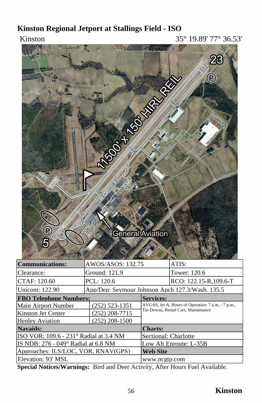
Kinston Regional Jetport at Stallings Field - ISO
Kinston 35° 19.89' 77° 36.53'
AWOS/ASOS: 132.75 ATIS:
Clearance: Ground: 121.9 Tower: 120.6
CTAF: 120.60
Communications:
PCL: 120.6 RCO: 122.15-R,109.6-T
Unicom: 122.90 App/Dep: Seymour Johnson Apch 127.3/Wash. 135.5
FBO Telephone Numbers: Services:AVGAS, Jet A, Hours of Operation: 7 a.m. - 7 p.m.,Tie-Downs, Rental Cars, Maintenance
Charts:Navaids:
Web SiteElevation: 93' MSL www.ncgtp.com Bird and Deer Activity, After Hours Fuel Available.Special Notices/Warnings:
Kinston
Main Airport Number (252) 523-1351Kinston Jet Center (252) 208-7715Henley Aviation (252) 208-1500
ISO VOR: 109.6 - 231° Radial at 3.4 NMIS NDB: 276 - 049° Radial at 6.8 NMApproaches: ILS/LOC, VOR, RNAV(GPS)
Sectional: CharlotteLow Alt Enroute: L-35B
56

Raleigh East Airport - W17
Knightdale 35° 47.86' 78° 26.22'
AWOS/ASOS: ATIS:
Clearance: Ground: Tower:
CTAF: 122.80
Communications:
PCL: RCO:
Unicom: 122.80 App/Dep: Raleigh 125.3
FBO Telephone Numbers: Services:MOGAS, Hours of Operation: Attended irregularlyTie-Downs
Charts:Navaids:
Web SiteElevation: 313' MSL Ry 19 Thr Aprxly 40' Higher Than Ry 01 Thr (SlopesUphill To The North) Deer Activity On & Invof ArptSpecial Notices/Warnings:
Knightdale
Airport (919) 676-8479After Hours Fuel Call (919) 833-5207
RDU VOR: 117.2-109° Radial at 17.4 NM Sectional: CharlotteLow Alt Enroute:
57

Davidson County Airport - EXX
Lexington 35° 46.87' 80° 18.23'
AWOS/ASOS: 119.825 ATIS:
Clearance: 135.07 Ground: Tower:
CTAF: 122.80
Communications:
PCL: 122.8 RCO: 135.075
Unicom: 122.80 App/Dep: Greensboro Approach 126.6
FBO Telephone Numbers: Services:AVGAS, Jet A, Hours of Operation: Apr. - Oct. 8 a.m.- 8 p.m. Nov. - Mar. 8 a.m. - 7 p.m., Tie-Downs, RentalCars, WIFI
Charts:Navaids:
Web SiteElevation: 733' MSL www.flyhighlexington.com Deer and Coyote Activity.Special Notices/Warnings:
Lexington
Fly High Lexington (336) 956-7774After hours fuel (404) 867-5535
GSO VOR: 116.2 - 228° Radial at 22.5 NM
App: ILS/LOC,VOR-DME,RNAV(GPS)
Sectional: CharlotteLow Alt Enroute: L-25D, 36F
58

Causey Airport - 2A5
Liberty 35° 54.71' 79° 37.06'
AWOS/ASOS: ATIS:
Clearance: Ground: Tower:
CTAF: 122.80
Communications:
PCL: 122.8 RCO:
Unicom: 122.80 App/Dep: Greensboro Approach 126.6
FBO Telephone Numbers: Services:AVGAS, Jet A, Hours of Operation: Mon - Sat 8 a.m. -5 p.m. & Sun 1 p.m. - 5 p.m., Tie-Downs, Maintenance
Charts:Navaids:
Web SiteElevation: 723' MSL See AFD for non-standard lights and markings.Buildings, aircraft and fuel pumps close to runway.Special Notices/Warnings:
Liberty
Causey Aviation (336) 685-4423
LIB VOR: 113.0 - 001° Radial at 6 NM
Approaches:VOR, RNAV(GPS)
Sectional: CharlotteLow Alt Enroute: L-25A, 36F
59

Hinshaw (Greenacres) Airport - N61
Liberty 35° 52.42' 79° 31.65'
AWOS/ASOS: ATIS:
Clearance: Ground: Tower:
CTAF: 122.90
Communications:
PCL: RCO:
Unicom: 122.90 App/Dep: Greensboro 126.6
FBO Telephone Numbers: Services:No Fuel Available, Hours of Operation: Unattended
Charts:Navaids:
Web SiteElevation: 750' MSL Fence alomg both sides of runway and end of runway 3.Ultralight Activit. In traffic pattern of Causey Arpt (2A5 - CTAF 122.8)Special Notices/Warnings:
Liberty
Airport (336) 622-4405
LIB VOR: 113.0 - 051° Radial at 5.6 NM Sectional: CharlotteLow Alt Enroute:
60

Lincolnton-Lincoln County Regional Airport - IPJ
Lincolnton 35° 29.00' 81° 09.68'
AWOS/ASOS: 119.675 ATIS:
Clearance: 124.90 Ground: Tower:
CTAF: 123.05
Communications:
PCL: 123.05 RCO: 124.9 (CLT)
Unicom: 123.05 App/Dep: Charlotte Approach 134.75
FBO Telephone Numbers: Services:AVGAS, Jet A, Hours of Operation: Apr.-Oct. 8 a.m.-7 p.m. Nov.-Mar. 8 a.m. - 6 p.m., Tie-Downs, RentalCars, Courtesy Car, Maintenance
Charts:Navaids:
Web SiteElevation: 878' MSL www.lincolncounty.org(airport) Caution: Airport Lies Beneath Charlotte Class BAirspace (See AFD), Rwy 5 dsplcd 200' and Rwy 23 dsplcd 201'.Special Notices/Warnings:
Lincolnton
Airport Main Number (704) 735-0602Premier Air (704) 748-1554
CLT VOR: 115.0 - 335° Radial at 20.3 NMIZN NDB: 432 - 234° Radial at 4.9Approaches: ILS/LOC, NDB, RNAV(GPS)
Sectional: CharlotteLow Alt Enroute: L-25D
61

Triangle North Executive Airport - LHZ
Louisburg 36° 01.40' 78° 19.82'
AWOS/ASOS: 118.325 ATIS:
Clearance: Ground: Tower:
CTAF: 123.00
Communications:
PCL: 123.0 RCO: (GCO) 135.075
Unicom: 123.00 App/Dep: Raleigh Approach 125.3
FBO Telephone Numbers: Services:AVGAS, Jet A, Hours of Operation: 8 a.m. - 6 p.m.,Tie-Downs, Rental Cars, Maintenance, WIFI
Charts:Navaids:
Web SiteElevation: 368' MSL www.flytrianglenorth.com Right Traffic Pattern for Rwy 05, Bird Activity.Skydiving Operations, Helicopter Flight Training, and Glider Activity Weekends.Special Notices/Warnings:
Louisburg
Airport Number (919) 496-1234Total Flight Solutions (919) 497-5511Plane Design (919) 614-0909
RDU VOR: 117.2 - 072° Radial at 23.9 NM
App: ILS/LOC, VOR-DME, RNAV(GPS)
Sectional: CharlotteLow Alt Enroute: L-35B, 36G
62
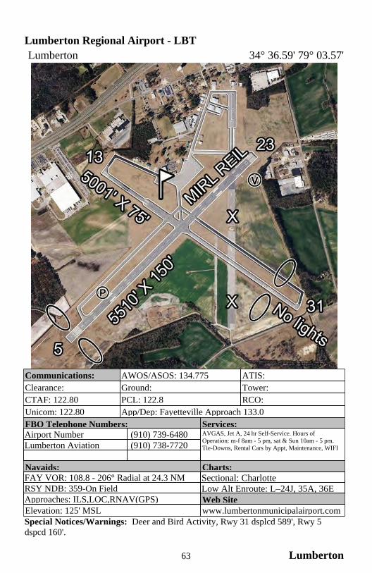
Lumberton Regional Airport - LBT
Lumberton 34° 36.59' 79° 03.57'
AWOS/ASOS: 134.775 ATIS:
Clearance: Ground: Tower:
CTAF: 122.80
Communications:
PCL: 122.8 RCO:
Unicom: 122.80 App/Dep: Fayetteville Approach 133.0
FBO Telephone Numbers: Services:AVGAS, Jet A, 24 hr Self-Service. Hours ofOperation: m-f 8am - 5 pm, sat & Sun 10am - 5 pm.Tie-Downs, Rental Cars by Appt, Maintenance, WIFI
Charts:Navaids:
Web SiteElevation: 125' MSL www.lumbertonmunicipalairport.com Deer and Bird Activity, Rwy 31 dsplcd 589', Rwy 5dspcd 160'.Special Notices/Warnings:
Lumberton
Airport Number (910) 739-6480Lumberton Aviation (910) 738-7720
FAY VOR: 108.8 - 206° Radial at 24.3 NMRSY NDB: 359-On FieldApproaches: ILS,LOC,RNAV(GPS)
Sectional: CharlotteLow Alt Enroute: L–24J, 35A, 36E
63

Laneys Airport - N92
Maiden 35° 34.46' 81° 07.04'
AWOS/ASOS: ATIS:
Clearance: Ground: Tower:
CTAF: 122.80
Communications:
PCL: RCO:
Unicom: 122.80 App/Dep: Charlotte 134.75
FBO Telephone Numbers: Services:No Fuel Available, Hours of Operation: 8 a.m. - Dusk
Charts:Navaids:
Web SiteElevation: 1025' MSL Unmarked Powerlines. Ultralight activity in area.Special Notices/Warnings:
Maiden
Airport Information (828) 428-8939
CLT VOR: 115.0 - 346° Radial at 24.4 NM Sectional: CharlotteLow Alt Enroute:
64

Dare County Regional Airport - MQI
Manteo 35° 55.14' 75° 41.73'
AWOS/ASOS: 128.275 ATIS:
Clearance: 124.72 Ground: Tower:
CTAF: 122.80
Communications:
PCL: 122.8 RCO: 124.725
Unicom: 122.80 App/Dep: Washington Center 124.725
FBO Telephone Numbers: Services:AVGAS 24 hr. Self-Service, Jet A, Hours ofOperation: 8am - 7pm, For after hours fuel call (252)216-7028 or (252) 216-8535. Tie-Downs, Rental Cars,Maintenance, WIFI
Charts:Navaids:
Web SiteElevation: 13' MSL www.darenc.com/airport Banner towing ops, Migratory bird activity, Rwy 5, 23 &17 displd approx. 300', Rwy 35 displd 1000', Caution trees rwy 17 and rwy 35.Special Notices/Warnings:
Manteo
Main Airport Number (252) 475-5575Barrier Island Aviation (252) 473-4247
RBX VOR: 111.6 - On FieldMQI NDB: 370 - On FieldApproaches: VOR, NDB,RNAV(GPS)
Sectional: CharlotteLow Alt Enroute: L-35D
65

Shiflet Field - 9A9
Marion 35° 43.24' 82° 00.59'
AWOS/ASOS: ATIS:
Clearance: Ground: Tower:
CTAF: 122.90
Communications:
PCL: RCO:
Unicom: 122.90 App/Dep: Atlanta Ctr. 125.15
FBO Telephone Numbers: Services:Unattended, Tie-Downs
Charts:Navaids:
Web SiteElevation: 1212' MSL http://shiflet.weebly.com/ Arpt clsd ngts, Arpt in river flood plain soft when wet;subject to flooding after heavy rains.Special Notices/Warnings:
Marion
Airport Number (828) 442-3260Airport Number (973) 865-9241Airport Number (828) 442-5500
SUG VOR: 112.2 - 036° Radial at 22.7 NM Sectional: AtlantaLow Alt Enroute:
66

Laurinburg-Maxton Airport - MEB
Maxton 34° 47.53' 79° 21.95'
AWOS/ASOS: 134.125 ATIS:
Clearance: 135.07 Ground: Tower:
CTAF: 122.80
Communications:
PCL: 122.8 RCO: 135.075
Unicom: 122.80 App/Dep: Fayetteville Approach 127.8
FBO Telephone Numbers: Services:AVGAS, Jet A, 24 hr Self-Service. Hours ofOperation: M-F 8am - 5pm. Tie-Downs, Rental CarsBy Appointment, Maintenance, After Hrs. Fuel Call(910) 277-0367 or (910) 318-6907
Charts:Navaids:
Web SiteElevation: 217' MSL http://www.lmairport.com/ Daily Parachute Jumping south side of airport. Runways23 & 31 right trafficSpecial Notices/Warnings:
Maxton
Scotland Aero Services: (910) 844-3601Airport Manger (910) 844-5081
SDZ VOR: 111.8 - 160° Radial at 27.6 NMME NDB: 257 - 055° Radial at 5.2 NMApproaches: ILS/LOC, RNAV(GPS)
Sectional: CharlotteLow Alt Enroute: L-35A, 36E
67

Hurdle Field - 4W7
Mebane 36° 04.34' 79° 16.84'
AWOS/ASOS: ATIS:
Clearance: Ground: Tower:
CTAF: 122.90
Communications:
PCL: RCO:
Unicom: 122.90 App/Dep: Raleigh 132.35
FBO Telephone Numbers: Services:No Fuel Available, Hours of Operation: Unattended
Charts:Navaids:
Web SiteElevation: 682' MSL Rwy 21 unmarked p-line is difficult to see.Special Notices/Warnings:
Mebane
Airport Number (919) 563-9610
RDU VOR: 117.2 - 300° Radial at 27 NM Sectional: CincinnatiLow Alt Enroute:
68

Twin Lakes Airport - 8A7
Mocksville 35° 54.89' 80° 27.41'
AWOS/ASOS: ATIS:
Clearance: Ground: Tower:
CTAF: 122.70
Communications:
PCL: 122.7 RCO:
Unicom: 122.70 App/Dep: Greensboro Approach 124.35
FBO Telephone Numbers: Services:AVGAS, Hours of Operation: 8 a.m. - 5 p.m. 24-Hr.self svc. fuel, Tie-Downs, Maintenance
Charts:Navaids:
Web SiteElevation: 818' MSL www.twinlakesairport.com Deer/migratory birds occasionally on Airport.Special Notices/Warnings:
Mocksville
Airport Number (336) 998-8101Extreme Aviation (336) 998-2126Twin Lakes Avionics (336) 998-6120
GSO VOR: 116.2 - 255º Radial at 24.7 NMApproaches: RNAV(GPS)
Sectional: CharlotteLow Alt Enroute: L-25D, 36F
69

Charlotte-Monroe Executive Airport - EQY
Monroe 35° 01.05' 80° 37.32'
AWOS/ASOS: 135.775 ATIS:
Clearance: 132.55 Ground: Tower:
CTAF: 122.70
Communications:
PCL: 122.7 RCO: 132.55 (CLT)
Unicom: 122.70 App/Dep: Charlotte Approach 120.05, 134.75
FBO Telephone Numbers: Services:AVGAS, JetA1+ , Hours of Operation: 6a.m. - 10p.m., Tie-Downs, Rental Cars, Maintenance, WiFi
Charts:Navaids:
Web SiteElevation: 683' MSL www.charlottemonroeairport.com Airport Lies Beneath Charlotte Class B Airspace, Birdand Deer Activity invof arpt.Special Notices/Warnings:
Monroe
Airport (704) 226-2300
CLT VOR: 115.0 - 127° Radial at 19.3 NMTWL NDB: 204 - 053° Radial at 5.6 NMApproaches: ILS/LOC,NDB, RNAV(GPS)
Sectional: CharlotteLow Alt Enroute: L-25D, 36E
70

Lake Norman Airpark - 14A
Mooresville 35° 36.83' 80° 53.97'
AWOS/ASOS: ATIS:
Clearance: Ground: Tower:
CTAF: 122.80
Communications:
PCL: 122.8 RCO:
Unicom: 122.80 App/Dep: Charlotte 134.75
FBO Telephone Numbers: Services:AVGAS, Jet A, Hours of Operation: 8 a.m. - 5 p.m.Daily, Tie-Downs, Hanger, WIFI
Charts:Navaids:
Web SiteElevation: 839' MSL www.racecityfo.com VFR operations at night only. Rwy 14 dsplcd 185' &uphill. Pulsating Visual Approach Slope Indicator (PVASI) operates dusk to dawn.Special Notices/Warnings:
Mooresville
Racing City Aviation (704) 662-6227After Hours Call (816) 721-4330
CLT VOR: 115.0 - 011° Radial at 25.5 NM
Approaches: RNAV(GPS)
Sectional: CharlotteLow Alt Enroute: L-25D, 36E
71

Foothills Regional Airport - MRN
Morganton 35° 49.21' 81° 36.68'
AWOS/ASOS: 124.175 ATIS:
Clearance: Ground: Tower:
CTAF: 122.70
Communications:
PCL: 122.7 RCO: 122.2, 122.6 (HKY)
Unicom: 122.70 App/Dep: Atlanta Center 125.15
FBO Telephone Numbers: Services:AVGAS, Jet A, Hours of Operation: M - Sat. 8am-sunset, Sun 9am - sunset. Tie-Downs, Rental Cars,Maintenance, WIFI
Charts:Navaids:
Web SiteElevation: 1270' MSL http://foothillsairport.com/ Deer and Coyote ActivitySpecial Notices/Warnings:
Morganton
Foothills Regional Aviation (828) 757-0099Fax (828) 764-4483After hous fuel (828) 757-0099
BZM VOR: 110.8 - 267° Radial at 18.3 NMFIQ NDB: 391 - 031° Radial at 7.2 NMApproaches: LOC, RNAV(GPS)
Sectional: CharlotteLow Alt Enroute: L-25C
72

Mount Airy/Surry County Airport - MWK
Mount Airy 36° 27.58' 80° 33.18'
AWOS/ASOS: 121.125 ATIS:
Clearance: Ground: Tower:
CTAF: 123.00
Communications:
PCL: 123.0 RCO: 135.075
Unicom: 123.00 App/Dep: Greensboro Approach 124.35
FBO Telephone Numbers: Services:AVGAS, Jet A, Hours of Operation: 8am - Dusk,Tie-Downs, Rental Cars by Appointment,Maintenance, WIFI
Charts:Navaids:
Web SiteElevation: 1249' MSL www.ra-techaviation.com Rwy 18 dsplcd 490'.Special Notices/Warnings:
Mount Airy
RA-Tech Aviation, LLC (336) 789-5153
GSO VOR: 116.2 - 315º Radial at 37.4 NMAZW NDB: 223 - 360º Radial at 4.8 NMApproaches: RNAV(GPS)
Sectional: CincinnatiLow Alt Enroute: L-26I
73

Mount Olive Municipal Airport - W40
Mount Olive 35° 13.29' 78° 02.32'
AWOS/ASOS: ATIS:
Clearance: Ground: Tower:
CTAF: 122.80
Communications:
PCL: 122.8 RCO:
Unicom: 122.80 App/Dep: Seymour Johnson App 119.7/Wash. Ctr 135.5
FBO Telephone Numbers: Services:AVGAS, Jet A, 24 hr. Self-Service. Hours ofOperation: 8 a.m. - 6 p.m., Tie-Downs, Rental Cars,Maintenance, WIFI
Charts:Navaids:
Web SiteElevation: 166' MSL www.bassaviation.com Rental Cars by Appointment, Low Level MilitaryActivity near Airport,Special Notices/Warnings:
Mount Olive
Bass Aviation, Inc. (919) 635-1471Maintenance (919) 635-1471After Hours Service (252) 234-7778
ISO VOR: 109.6 - 254° Radial at 25.2 NMApproaches: RNAV(GPS)
Sectional: CharlotteLow Alt Enroute: L-35B, 36F
74

Coastal Carolina Regional Airport - EWN
New Bern 35° 04.37' 77° 02.58'
AWOS/ASOS: 118.525 ATIS:
Clearance: 121.70 Ground: 121.7 Tower: 124.25
CTAF: 124.25
Communications:
PCL: 124.25 RCO: 122.4 (RDU FSS)
Unicom: 124.25 App/Dep: Cherry Point Approach 120.525
FBO Telephone Numbers: Services:AVGAS, Jet A, Call FBO to arrange after hrsserv.Hours of Operation: 6am - 8pm. Tie-Downs,Rental Cars by appointment, Maintenance WIFI
Charts:Navaids:
Web SiteElevation: 18' MSL www.newbernairport.com Call Cherry Point for Clearance on 120.525 when toweris closed.Special Notices/Warnings:
New Bern
Main Airport Number (252) 638-8591Tidewater Air Services (252) 633-1400Tradewind Aviation (252) 636-0716
EWN VOR: 113.6 - On Field
Approaches: ILS, VOR, RNAV(GPS)
Sectional: CharlotteLow Alt Enroute: L-35B
75

Wilkes County Airport - UKF
North Wilkesboro 36° 13.42' 81° 05.92'
AWOS/ASOS: 126.625 ATIS:
Clearance: Ground: Tower:
CTAF: 122.70
Communications:
PCL: 122.7 RCO: 122.4 (RDU FSS)
Unicom: 122.70 App/Dep: Atlanta Center 125.15
FBO Telephone Numbers: Services:AVGAS, Jet A, Hours of Operation: Dawn to Dusk,Tie-Downs, Maintenance, WIFI
Charts:Navaids:
Web SiteElevation: 1303' MSL www.wilkescounty.net/airport Deer Activity on airport.Special Notices/Warnings:
North Wilkesboro
Airport Number (336) 696-2000
BZM VOR: 110.8 - 024° Radial at 22.3 NMUKF NDB: 209 - 006° Radial at 6.6 NMApproaches: ILS, GPS
Sectional: CincinnatiLow Alt Enroute: L-25D
76

Cape Fear Rgnl Jetport/Howie Franklin Fld - SUT
Oak Island 33° 55.85' 78° 04.40'
AWOS/ASOS: 124.175 ATIS:
Clearance: Ground: Tower:
CTAF: 123.05
Communications:
PCL: 123.05 RCO: 135.075
Unicom: 123.05 App/Dep: Wilmington App. 118.25, Wash. Ctr. 124.025
FBO Telephone Numbers: Services:AVGAS, Jet A, 24 hr. Self-Service. Hours ofOperation: 8am - 6pm, For SVC Afr Hrs Call (910)278-9896, Tie-Downs, Rental Cars,Maintenance,WIFI.,Brunswick Air (910) 363-4334
Charts:Navaids:
Web SiteElevation: 26' MSL www.capefearjetport.com Bird and Deer Activity, Banner Towing & Sight-SeeingOps, Parachute Jumping, Rwy 23 dsplcd 400'.Special Notices/Warnings:
Oak Island
Main Airport Number (910) 457-6483Oak Island Aviation (910) 279-7393Cape Fear Airworks (910) 367-3344
CRE VOR: 117.6 - 081° Radial at 33.3 NMILM VOR: 117.0 - 208° Radial at 27.1 NMApproaches: RNAV(GPS)
Sectional: CharlotteLow Alt Enroute: L-35A
77

DS Butler Farm and Airfield - N83
Oak Ridge 36° 11.71' 80° 00.32'
AWOS/ASOS: ATIS:
Clearance: Ground: Tower:
CTAF: 122.90
Communications:
PCL: RCO:
Unicom: 122.90 App/Dep: Greensboro 124.35
FBO Telephone Numbers: Services:No Fuel Available, 24 Hour Operation
Charts:Navaids:
Web SiteElevation: 950' MSL Airport Unattended, All takeoffs Rwy 19 and all landingsRwy 01 (Due to sloping Rwys).Special Notices/Warnings:
Oak Ridge
Airport Number (336) 362-0055
GSO VOR: 116.2 - 354º Radial at 9.1 NM Sectional: CincinnatiLow Alt Enroute:
78

Odell Williamson Municipal Airport - 60J
Ocean Isle Beach 33° 54.51' 78° 26.20'
AWOS/ASOS: ATIS:
Clearance: Ground: Tower:
CTAF: 122.90
Communications:
PCL: 122.9 RCO:
Unicom: 122.90 App/Dep: Myrtle Beach 119.2
FBO Telephone Numbers: Services:AVGAS, 24 hour self-service, Hours of Operation:Seasonal (see AFD), Tie-Downs
Charts:Navaids:
Web SiteElevation: 32' MSL www.oibaviation.com Runway 24 displaced 200', powe lines. Pilot lounge code- (emer. freq.)Special Notices/Warnings:
Ocean Isle Beach
Ocean Isle Beach (town) (910) 579-2166Ocean Isle Beach Aviation (910)579-6152
CRE VOR: 117.6 - 071° Radial at 15.4 NM Sectional: CharlotteLow Alt Enroute: L-35A
79

Ocracoke Island Airport - W95
Ocracoke 35° 06.07' 75° 57.96'
AWOS/ASOS: ATIS:
Clearance: Ground: Tower:
CTAF: 122.90
Communications:
PCL: No Lights RCO:
Unicom: 122.90 App/Dep: Cherry Point 119.75
FBO Telephone Numbers: Services:No Fuel available, Hours of Operation: Unattended,Tie-Downs
Charts:Navaids:
Web SiteElevation: 5' MSL Arpt closed 30 Min. after SS until 30 Min. before SR,Heavy seagull activity, Night tkf prohibited, High Speed Mil Acft invof airport. Toaccess building, enter (VFR squawk) in key pad.
Special Notices/Warnings:
Ocracoke
NCDOT Aviation (Raleigh) (919) 814-0550
EWN VOR: 113.6- 096° Radial at 53.2 NM
Approaches: RNAV(GPS)
Sectional: CharlotteLow Alt Enroute: L-35C
80

Henderson-Oxford Airport - HNZ
Oxford 36° 21.69' 78° 31.75'
AWOS/ASOS: 118.625 ATIS:
Clearance: 135.07 Ground: Tower:
CTAF: 122.80
Communications:
PCL: 122.8 RCO: 135.07
Unicom: 122.80 App/Dep: Raleigh Approach 132.35
FBO Telephone Numbers: Services:AVGAS, Jet A, 24 hr. self-service. Hours of Operation:8am - 6pm, Tie-Downs, Rental Cars, Maintenance,WIFI
Charts:Navaids:
Web SiteElevation: 526' MSL Rotating Beacon Obscured East of Airport by Trees.Special Notices/Warnings:
Oxford
Airport (919) 693-5769After hours service (919) 603-4801
SBV VOR: 110.4 - 134° Radial at 30.1 NMHXO NDB: 271 - 057° Radial at 5.6 NMApproaches: LOC, NDB, RNAV(GPS)
Sectional: WashingtonLow Alt Enroute: L-36G
81

Moore County Airport - SOP
Pinehurst/Southern Pines 35° 14.25' 79° 23.34'
AWOS/ASOS: 127.575 ATIS:
Clearance: 127.00 Ground: Tower:
CTAF: 123.05
Communications:
PCL: 123.05 RCO: 127.0 (FAY)
Unicom: 123.05 App/Dep: Fayetteville Approach 127.8
FBO Telephone Numbers: Services:AVGAS, Jet A, Hours of Operation: 8am - 8pm,Tie-Downs, Rental Cars, Maintenance, FlightInstruction, WIFI
Charts:Navaids:
Web SiteElevation: 459' MSL www.moorecountyairport.com Deer & Bird activity on & invof arpt, Noise abatementprocedures (See AFD).Special Notices/Warnings:
Pinehurst/Southern Pines
Moore County Airport (910) 692-3212
SDZ VOR: 111.8 - 085° Radial at 9.9 NM
Approaches: ILS, RNAV(GPS)
Sectional: CharlotteLow Alt Enroute: L-35A, 36F
82

Pink Hill Airport - 4W9
Pink Hill 35° 03.04' 77° 44.17'
AWOS/ASOS: ATIS:
Clearance: Ground: Tower:
CTAF: 122.70
Communications:
PCL: 122.7 RCO:
Unicom: 122.70 App/Dep: Seymour Johnson 119.7
FBO Telephone Numbers: Services:No Fuel available, Hours of Operation: Unattended,Tie-Downs
Charts:Navaids:
Web SiteElevation: 144' MSL Rwy 1 & 19 dsplcd 200', Low Level & High SpeedMilitary Activity invof arpt, See AFD for non-standard lighting.Special Notices/Warnings:
Pink Hill
Airport Number (252) 568-4366
ISO VOR: 109.6 - 209° Radial at 21.1 NM Sectional: CharlotteLow Alt Enroute:
83
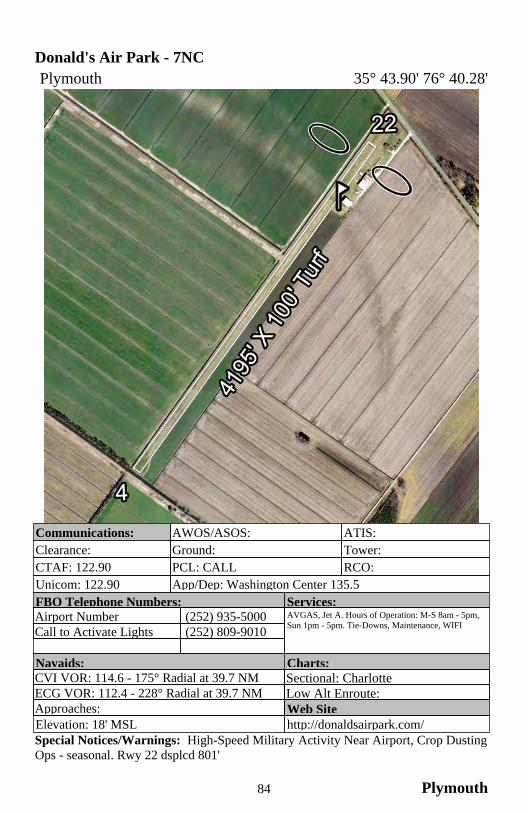
Donald's Air Park - 7NC
Plymouth 35° 43.90' 76° 40.28'
AWOS/ASOS: ATIS:
Clearance: Ground: Tower:
CTAF: 122.90
Communications:
PCL: CALL RCO:
Unicom: 122.90 App/Dep: Washington Center 135.5
FBO Telephone Numbers: Services:AVGAS, Jet A. Hours of Operation: M-S 8am - 5pm,Sun 1pm - 5pm. Tie-Downs, Maintenance, WIFI
Charts:Navaids:
Web SiteElevation: 18' MSL http://donaldsairpark.com/ High-Speed Military Activity Near Airport, Crop DustingOps - seasonal. Rwy 22 dsplcd 801'Special Notices/Warnings:
Plymouth
Airport Number (252) 935-5000Call to Activate Lights (252) 809-9010
CVI VOR: 114.6 - 175° Radial at 39.7 NMECG VOR: 112.4 - 228° Radial at 39.7 NMApproaches:
Sectional: CharlotteLow Alt Enroute:
84

Plymouth Municipal Airport - PMZ
Plymouth 35° 48.65' 76° 45.50'
AWOS/ASOS: ATIS:
Clearance: Ground: Tower:
CTAF: 122.80
Communications:
PCL: 122.8 RCO:
Unicom: 122.80 App/Dep: Washington Center 135.5
FBO Telephone Numbers: Services:AVGAS, Jet A, 24 hr. self-service.Hours of Operation:8am - 5pm. Pilot lounge,Tie-Downs, Rental Cars,Maintenance, WIFI
Charts:Navaids:
Web SiteElevation: 36' MSL www.visitplymouthnc.com High-Speed Military Activity Near Airport.Special Notices/Warnings:
Plymouth
Airport Number (252) 793-9801After Hrs. Fuel (252) 793-9801
CVI VOR: 114.6 - 180° Radial at 34.1 NM
Approaches: RNAV(GPS)
Sectional: CharlotteLow Alt Enroute: L-35C
85

PK Airpark - 5W4
Raeford 35° 01.19' 79° 11.46'
AWOS/ASOS: ATIS:
Clearance: Ground: Tower:
CTAF: 123.00
Communications:
PCL: 123.0 RCO:
Unicom: 123.00 App/Dep: Fayetteville Approach 127.8
FBO Telephone Numbers: Services:AVGAS, Jet A, Hours of Operation: 8 a.m. - Dusk,Tie-Downs,
Charts:Navaids:
Web SiteElevation: 304' MSL www.raeford-aviation.com/ Rwy 22 right traffic, Heavy parachute activity - Monitor123.5, Low lvl & high speed mil aircraft invof airport,Special Notices/Warnings:
Raeford
Raeford Aviation (910) 875-3261Airport Manager (910) 316-7798
FAY VOR: 108.8 - 282° Radial at 15.7 NM
Approaches: VOR-DME, GPS
Sectional: CharlotteLow Alt Enroute: L-35A, 36F
86

Triple W Airport - 5W5
Raleigh 35° 37.22' 78° 42.02'
AWOS/ASOS: ATIS:
Clearance: Ground: Tower:
CTAF: 122.70
Communications:
PCL: 122.7 RCO:
Unicom: 122.70 App/Dep: Raleigh Approach 125.3
FBO Telephone Numbers: Services:AVGAS, Hours of Operation: Attended Irregularly,Rental cars by appointment. Tie-Downs, Maintenance
Charts:Navaids:
Web SiteElevation: 244' MSL Deer activity. See AFD for non-standard lighting.Special Notices/Warnings:
Raleigh
owner (919) 552-6877
RDU VOR: 117.2 - 169° Radial at 15.6 NM Sectional: CharlotteLow Alt Enroute: L-35B, 36F
87

Raleigh-Durham International Airport - RDU
Raleigh 35° 52.66' 78° 47.25'
AWOS/ASOS: 123.800 ATIS: 123.8
Clearance: 120.10 Ground: 121.9 Tower: 127.45/119.3
CTAF:
Communications:
PCL: RCO: 122.2/122.45/122.65
Unicom: 122.95 App/Dep: 128.3/124.95/132.35/125.3 (See AFD)
FBO Telephone Numbers: Services:AVGAS, Jet A, 24-Hr. Operation, Tie-Downs, RentalCars, Aircraft & Avionics Maint.
Charts:Navaids:
Web SiteElevation: 435' MSL www.rdu.comSpecial Notices/Warnings:
Raleigh
Landmark Aviation (919) 840-2200TAC Air (919) 840-4400FlightGest Aviation (919) 840-4444
RDU VOR: 117.2 - On FieldLE NDB: 350 - 234° Radial at 4.4 NMApproaches: ILS,LOC, VOR, RNAV(GPS)
Sectional: CharlotteLow Alt Enroute: L-36F
88

Rockingham County-NC Shiloh Airport - SIF
Reidsville 36° 26.23' 79° 51.06'
AWOS/ASOS: 119.775 ATIS:
Clearance: Ground: Tower:
CTAF: 122.80
Communications:
PCL: 122.8 RCO:
Unicom: 122.80 App/Dep: Greensboro Approach 124.35
FBO Telephone Numbers: Services:AVGAS 24 hr. self-serve, Jet A, Hours of Operation: 8a.m. - 6 p.m., Tie-Downs, Rental Cars, Maintenance,WIFI
Charts:Navaids:
Web SiteElevation: 694' MSL www.shilohairport.com Deer activity. Runway 13 threshold displaced 200'.Special Notices/Warnings:
Reidsville
Airport Number (336) 573-3115
GSO VOR: 116.2 - 018° Radial at 24.2 NMSIF NDB: 423 - 315° Radial at 5.4 NMApproaches: VOR-DME, NDB, RNAV(GPS)
Sectional: CincinnatiLow Alt Enroute: L-26J, 36F
89

Warf Airport - 6A5
Reidsville 36° 19.44' 79° 42.56'
AWOS/ASOS: ATIS:
Clearance: Ground: Tower:
CTAF: 122.90
Communications:
PCL: RCO:
Unicom: 122.90 App/Dep: Greensboro 126.6
FBO Telephone Numbers: Services:No Fuel Available, Hours of Operation: Unattended
Charts:Navaids:
Web SiteElevation: 820' MSL Deer activity. Rwy 35 has uphill grade,Special Notices/Warnings:
Reidsville
Airport Number (336) 349-2195
GSO VOR: 116.2 - 041° Radial at 21.1 NM Sectional: CincinnatiLow Alt Enroute:
90

Halifax-Northampton Regional Airport - IXA
Roanoke Rapids 36° 19.79' 77° 38.11'
AWOS/ASOS: 119.975 ATIS:
Clearance: Ground: Tower:
CTAF: 123.07
Communications:
PCL: 123.075 RCO:
Unicom: 123.07 App/Dep: Wahington Ctr. 132.02
FBO Telephone Numbers: Services:AVGAS, Jet A, 24 hr self svc fuel, Hours of Operation:M-S 8am - 5pm, Sun 12pm - 5 pm. Tie-Downs, WIFI,24 hr access to pilot lounge, call (252) 673-2793 forcode.
Charts:Navaids:
Web SiteElevation: 145' MSL www.halifaxdevelopment.com Bird activitySpecial Notices/Warnings:
Roanoke Rapids
Airport Number (252) 583-3492After hours service (252) 673-2793
TYI VOR: 117.8 - 014° Radial at 21.4 NM
Approaches: RNAV(GPS), VOR/DME
Sectional: WashingtonLow Alt Enroute: L-35C, 36G
91

Richmond County Airport - RCZ
Rockingham 34° 53.48' 79° 45.58'
AWOS/ASOS: 118.775 ATIS:
Clearance: Ground: Tower:
CTAF: 122.80
Communications:
PCL: 122.8 RCO:
Unicom: 122.80 App/Dep: Fayetteville Approach 127.8
FBO Telephone Numbers: Services:AVGAS, Jet A, 24 hr. self-service. Hours of Operation:7:30 a.m. - 5:30 p.m. (Mon - Sat), Sunday: On Call,Tie-Downs, Rental Cars, Hangers, WIFI
Charts:Navaids:
Web SiteElevation: 358' MSL Rwy 32 threshold displaced 200' and Rwy 14 thresholddisplaced 150'.Special Notices/Warnings:
Rockingham
Richmond County (910) 997-5071After hours (910) 895-6691
SDZ VOR: 111.8 - 207° Radial at 21.2 NM
Approaches: RNAV(GPS)
Sectional: CharlotteLow Alt Enroute: L-25E, 35A, 36E
92

Rocky Mount-Wilson Regional Airport - RWI
Rocky Mount 35° 51.38' 77° 53.52'
AWOS/ASOS: 118.875 ATIS:
Clearance: 122.30 Ground: Tower:
CTAF: 123.05
Communications:
PCL: 123.05 RCO: 122.3 (FSS)
Unicom: 123.05 App/Dep: Washington Center 118.475
FBO Telephone Numbers: Services:AVGAS, Jet A, Hours of Operation: M - F 7am - 7pm,Sat - Sun 8am - 6pm. Tie-Downs, Rental Cars,Maintenance, WIFI
Charts:Navaids:
Web SiteElevation: 158' MSL www.aircareav.com ILS Unmonitored.Special Notices/Warnings:
Rocky Mount
AirCare (252) 977-1717Airport Authority (252) 446-7057
TYI VOR: 117.8 - 237° Radial at 11.7 NMISO VOR: 109.6 - 336° Radial at 33.4 NMApproaches: ILS, VOR-DME, RNAV(GPS)
Sectional: CharlotteLow Alt Enroute: L-35B, 36G
93

Person County Airport - TDF
Roxboro 36° 17.08' 78° 59.08'
AWOS/ASOS: 126.725 ATIS:
Clearance: 119.70 Ground: Tower:
CTAF: 122.70
Communications:
PCL: 122.7 RCO: 119.7 (RDU)
Unicom: 122.70 App/Dep: Raleigh Approach 132.35
FBO Telephone Numbers: Services:AVGAS, Jet A, Hours of Operation: 9am - 5pm.,Tie-Downs, Rental Cars, Maintenance, WIFI
Charts:Navaids:
Web SiteElevation: 609' MSL www.personcounty.net(Airport) Deer and Bird Activity.Special Notices/Warnings:
Roxboro
Red Mountain Aviation (336) 364-1111Fax (336) 364-2224After hours service (615) 351-9845
SBV VOR: 110.4- 181° Radial at 23.4 NMHUR NDB: 220 - 060° Radial at 5.0 NMApproaches: ILS,LOC,RNAV(GPS)
Sectional: WashingtonLow Alt Enroute: L-26J, 36G
94

Rutherford County-Marchman Field - FQD
Rutherfordton 35° 25.69' 81° 56.10'
AWOS/ASOS: 118.275 ATIS:
Clearance: Ground: Tower:
CTAF: 122.80
Communications:
PCL: 122.8 RCO:
Unicom: 122.80 App/Dep: Greer Approach 119.4/Atlanta Cntr 132.62
FBO Telephone Numbers: Services:AVGAS, Jet A, Hours of Operation: 9 am - 6 pm.Tie-Downs, Rental Cars, Maintenance, WIFI
Charts:Navaids:
Web SiteElevation: 1077' MSL http://rutherfordcountync.gov/airport Deer activitySpecial Notices/Warnings:
Rutherfordton
Main Airport Number (828) 287-0800After hours service (828) 755-7261
SPA VOR: 115.7 - 001° Radial at 23.6NM
Approaches: LOC, RNAV(GPS)
Sectional: CharlotteLow Alt Enroute: L-25C
95

Rowan County Airport - RUQ
Salisbury 35° 38.75' 80° 31.22'
AWOS/ASOS: 118.175 ATIS:
Clearance: 127.35 Ground: Tower:
CTAF: 122.80
Communications:
PCL: 122.8 RCO: 127.35 (CLT)
Unicom: 122.80 App/Dep: Charlotte Approach 128.32
FBO Telephone Numbers: Services:AVGAS, Jet A,24 Self Service. Carolina Avionics &Interiors (704) 630-0211, Alpha One Air Service (704)633-0021, Boss Aircraft Refinishers & Maintenance(704) 310-1421, AMOS Aviation (704) 507-7945
Charts:Navaids:
Web SiteElevation: 772' MSL www.rowancountyairport.com Helicopter, aerobatics, parachute, and deer activity.Hours of Operation: 8 am - 8 pm. Tie-Downs, Rental Cars, Maintenance, WIFISpecial Notices/Warnings:
Salisbury
Rowan County Airport (704) 216-7749After Hours Service (704) 239-1836
CLT VOR: 115.0 - 043° Radial at 34.5 NMRU NDB: 275 - 202° Radial at 5.4 NMApproaches: ILS,LOC,NDB, RNAV(GPS)
Sectional: CharlotteLow Alt Enroute: L-25D, 36E
96

Raleigh Exec. Jetport at Sanford-Lee County - TTA
Sanford 35° 34.95' 79° 06.08'
AWOS/ASOS: 120.625 ATIS:
Clearance: 135.07 Ground: Tower:
CTAF: 123.07
Communications:
PCL: 123.075 RCO: 135.075
Unicom: 123.07 App/Dep: Raleigh Approach 125.3
FBO Telephone Numbers: Services:AVGAS, Jet A, 24 hr. self-service. Hours of Operation:M-Sat 8 am - 6 pm Sun Noon - 6 pm. After HoursService (919) 770-5945,Tie-Downs, Rental Cars,Maintenance, WIFI
Charts:Navaids:
Web SiteElevation: 246' MSL www.raleighexec.comSpecial Notices/Warnings:
Sanford
Terminal (919) 776-2939Sanford Aircraft Srvcs (919) 708-5549Wings of Carolina (919) 776-2003
SDZ VOR: 111.8 - 050° Radial at 32.4 NMTT NDB: 406 - 028° Radial at 5.4 NMApproaches: ILS,LOC,RNAV(GPS)
Sectional: CharlotteLow Alt Enroute: L-36F
97
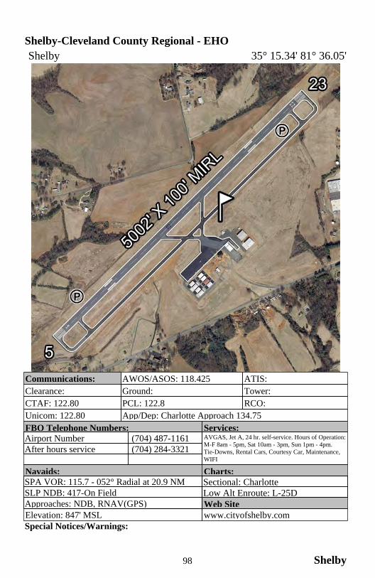
Shelby-Cleveland County Regional - EHO
Shelby 35° 15.34' 81° 36.05'
AWOS/ASOS: 118.425 ATIS:
Clearance: Ground: Tower:
CTAF: 122.80
Communications:
PCL: 122.8 RCO:
Unicom: 122.80 App/Dep: Charlotte Approach 134.75
FBO Telephone Numbers: Services:AVGAS, Jet A, 24 hr. self-service. Hours of Operation:M-F 8am - 5pm, Sat 10am - 3pm, Sun 1pm - 4pm.Tie-Downs, Rental Cars, Courtesy Car, Maintenance,WIFI
Charts:Navaids:
Web SiteElevation: 847' MSL www.cityofshelby.comSpecial Notices/Warnings:
Shelby
Airport Number (704) 487-1161After hours service (704) 284-3321
SPA VOR: 115.7 - 052° Radial at 20.9 NMSLP NDB: 417-On FieldApproaches: NDB, RNAV(GPS)
Sectional: CharlotteLow Alt Enroute: L-25D
98
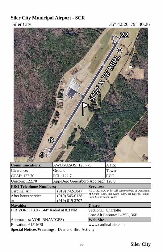
Siler City Municipal Airport - SCR
Siler City 35° 42.26' 79° 30.26'
AWOS/ASOS: 125.775 ATIS:
Clearance: Ground: Tower:
CTAF: 122.70
Communications:
PCL: 122.7 RCO:
Unicom: 122.70 App/Dep: Greensboro Approach 126.6
FBO Telephone Numbers: Services:AVGAS, Jet A, 24 hr. self-service Hours of Operation:M-S 9am - 5pm, Sun 12pm - 5pm. Tie-Downs, RentalCars, Maintenance, WIFI
Charts:Navaids:
Web SiteElevation: 615' MSL www.cardinal-air.com Deer and Bird ActivitySpecial Notices/Warnings:
Siler City
Cardinal Air (919) 742-3847After hours service (919) 545-0138or (919) 619-2707
LIB VOR: 113.0 - 144° Radial at 8.3 NM
Approaches: VOR, RNAV(GPS)
Sectional: CharlotteLow Alt Enroute: L-25E, 36F
99

Johnston Regional Airport - JNX
Smithfield 35° 32.46' 78° 23.42'
AWOS/ASOS: 120.225 ATIS:
Clearance: 135.07 Ground: Tower:
CTAF: 122.80
Communications:
PCL: 122.8 RCO: 135.075 (RDU)
Unicom: 122.80 App/Dep: Raleigh Approach 125.3
FBO Telephone Numbers: Services:AVGAS, Jet A, Hours of Operation: M-F 7am - 7pm,S-S 8am - 6pm. Tie-Downs, Rental Cars, Maintenance,WIFI, After Hrs Fuel Call (919) 796-3688
Charts:Navaids:
Web SiteElevation: 164' MSL www.JNX-airport.com Deer Activity, See AFD for noise abatement proceedures.Special Notices/Warnings:
Smithfield
Main Airport Number (919) 934-0992Sparkchasers (919) 934-1654Mobile Aircraft Repair (919) 934-5468
RDU VOR: 117.2 - 140° Radial at 27.6 NMJN NDB: 263 - 032° Radial at 4.3 NMApproaches: ILS,LOC,NDB,RNAV(GPS)
Sectional: CharlotteLow Alt Enroute: L-35B, 36F
100

Avery County/Morrison Field - 7A8
Spruce Pine 35° 56.72' 81° 59.78'
AWOS/ASOS: "Super" ATIS:
Clearance: Ground: Tower:
CTAF: 123.00
Communications:
PCL: No Lights RCO:
Unicom: 123.00 App/Dep: Atlanta Center 125.15
FBO Telephone Numbers: Services:AVGAS, Jet-A, 24 hr. self-service. Hrs of operationTu-Fr 9-5, Sat.&Sun. Irregularly, tiedown, rental cars(call ahead), maintenance, WIFI
Charts:Navaids:
Web SiteElevation: 2750' MSL www.ryanairplanecompany.com High terrain all quadrants, Runway 17 right traffic. SeeAFD for hazards and proceedures.Special Notices/Warnings:
Spruce Pine
Ryan Airplane Co. (828) 766-8187Cell (828) 467-1914
HMV VOR: 114.6- 172° Radial at 30.1 NM
VFR Only
Sectional: CharlotteLow Alt Enroute: L-25C
101

Montgomery County Airport - 43A
Star 35° 23.08' 79° 47.42'
AWOS/ASOS: ATIS:
Clearance: Ground: Tower:
CTAF: 122.80
Communications:
PCL: 122.8 RCO:
Unicom: 122.80 App/Dep: Fayetteville 127.8
FBO Telephone Numbers: Services:AVGAS, Hours of Operation: on-call. Tie-Downs,Maintenance
Charts:Navaids:
Web SiteElevation: 632' MSL Deer activity, Runway 21 threshold displaced 460'.Special Notices/Warnings:
Star
Airport Manager (910) 576-4221After hours service (910) 220-1218
SDZ VOR: 111.8 - 319° Radial at 14.2 NM
Approaches: RNAV(GPS)
Sectional: CharlotteLow Alt Enroute: L-25E, 36F
102

Statesville Regional Airport - SVH
Statesville 35° 45.90' 80° 57.23'
AWOS/ASOS: 119.225 ATIS:
Clearance: Ground: Tower:
CTAF: 123.07
Communications:
PCL: 123.075 RCO:
Unicom: 123.07 App/Dep: Atlanta Center 125.15
FBO Telephone Numbers: Services:AVGAS, Jet A, Hours of Operation: M-F 6am - 9pm,Sat-Sun 8am - 9pm, Tie-Downs, Rental Cars,Maintenance, WIFI
Charts:Navaids:
Web SiteElevation: 968' MSL www.statesvilleairport.com Runway 10 threshold displaced 998', Runway 28displaced 552'.Special Notices/Warnings:
Statesville
Statesville Flying Srvc (704) 873-1111
BZM VOR: 110.80 - 120° Radial at 15.3 NM
App: ILS/LOC,VOR-DME,RNAV(GPS)
Sectional: CharlotteLow Alt Enroute: L-25D
103

Jackson County Airport - 24A
Sylva 35° 19.03' 83° 12.58'
AWOS/ASOS: ATIS:
Clearance: Ground: Tower:
CTAF: 123.00
Communications:
PCL: 123.0 RCO:
Unicom: 123.00 App/Dep: Atlanta Center 134.8
FBO Telephone Numbers: Services:AVGAS, 24 hr. self-service. Hours of Operation:Unattended, Tie-Downs
Charts:Navaids:
Web SiteElevation: 2857' MSL www.co.jackson.mi.us/airport/ High Terrain all Quadrants. RWY 33 Dsplcd 150'Special Notices/Warnings:
Sylva
Airport Contact Number 828-586-0321
SOT VOR: 108.8 -199° Radial at 29.4 NM
Approaches: RNAV(GPS)
Sectional: AtlantaLow Alt Enroute: L-25B
104

Tarboro-Edgecombe Airport - ETC
Tarboro 35° 56.24' 77° 32.79'
AWOS/ASOS: 119.575 ATIS:
Clearance: Ground: Tower:
CTAF: 122.90
Communications:
PCL: 122.9 RCO:
Unicom: 122.90 App/Dep: Washington Center 118.475
FBO Telephone Numbers: Services:No Fuel Available, Hours of Operation: Unattended,Tie-Downs
Charts:Navaids:
Web SiteElevation: 53' MSL Runway 9 threshold displaced 200', Military aircraft anddeer activity.Special Notices/Warnings:
Tarboro
Airport Number (252) 641-4233
TYI VOR: 117.8 - 112° Radial at 8.0 NMETC NDB: 257 - On FieldApproaches: VOR-DME or GPS, NDB
Sectional: CharlotteLow Alt Enroute: L-35C, 36G
105

Taylorsville Airport - NC2
Taylorsville 35° 55.85' 81° 11.80'
AWOS/ASOS: ATIS:
Clearance: Ground: Tower:
CTAF: 122.90
Communications:
PCL: RCO:
Unicom: 122.90 App/Dep: Atlanta Center 125.15
FBO Telephone Numbers: Services:No Fuel Available, Hours of Operation: Unattended
Charts:Navaids:
Web SiteElevation: 1090' MSL Winds permitting tkf Rwy 26 ldg Rwy 8Special Notices/Warnings:
Taylorsville
Airport Number (828)-514-7731 or Call (828) 455-5566
BZM VOR: 110.8 - 036° Radial at 4.3 NM Sectional: Atlanta
106

Hiatt Airport - N97
Thomasville 35° 49.81' 80° 06.45'
AWOS/ASOS: ATIS:
Clearance: Ground: Tower:
CTAF: 122.90
Communications:
PCL: 122.9 RCO:
Unicom: 122.90 App/Dep: Greensboro 118.5
FBO Telephone Numbers: Services:AVGAS, Hours of Operation: Noon - Dusk,Tie-Downs, Hangars, Maintenance
Charts:Navaids:
Web SiteElevation: 855' MSL Rwy 09-27 used primarily for ultralights,Special Notices/Warnings:
Thomasville
Airport Number (336) 472-2314Fuel (336) 881-0248
GSO VOR: 116.2 - 209° Radial at 14.4 NM Sectional: CharlotteLow Alt Enroute:
107

Anson County Airport - AFP
Wadesboro 35° 01.24' 80° 04.63'
AWOS/ASOS: 119.325 ATIS:
Clearance: Ground: Tower:
CTAF: 122.80
Communications:
PCL: 122.8 RCO:
Unicom: 122.80 App/Dep: Charlotte Approach 120.05
FBO Telephone Numbers: Services:AVGAS, 24 hr. self-service, Jet A. Hours ofOperation: 8 a.m.- 5 p.m., Tie-Downs, WIFI
Charts:Navaids:
Web SiteElevation: 300' MSL www.co.anson.nc.us Deer Activity.Special Notices/Warnings:
Wadesboro
Anson County Airport (704) 694-2516After Hrs. Fuel (704) 848-4612
SDZ VOR: 111.8 - 247° Radial at 26.8 NM
Approaches: ILS,LOC,RNAV(GPS)
Sectional: CharlotteLow Alt Enroute: L-25E, 36E
108

Henderson Field - ACZ
Wallace 34° 43.07' 78° 00.23'
AWOS/ASOS: ATIS:
Clearance: Ground: Tower:
CTAF: 122.80
Communications:
PCL: 122.8 RCO:
Unicom: 122.80 App/Dep: ILM App 135.75/ Washington Center 124.025
FBO Telephone Numbers: Services:AVGAS, Jet A, 24 hr. self-service. Code for 24 hr.pilot lounge on fuel receipt. Hours of Operation: M-F8-5, Sat 9-6, Sun 1-6. Tie-Downs, Maintenance, WIFI
Charts:Navaids:
Web SiteElevation: 38' MSL Runway 9 threshold displaced 149', runway 27 displaced151'. Parachute JumpingSpecial Notices/Warnings:
Wallace
Main Airport Number (910) 285-6642
ISO VOR: 109.6 - 214° Radial at 44.9 NM
Approaches: RNAV(GPS)
Sectional: CharlotteLow Alt Enroute: L-35B
109

Meadow Brook Field - N63
Walnut Cove 36° 18.09' 80° 08.90'
AWOS/ASOS: ATIS:
Clearance: Ground: Tower:
CTAF: 123.00
Communications:
PCL: 123.0 RCO:
Unicom: 123.00 App/Dep: Greensboro Approach 124.35
FBO Telephone Numbers: Services:AVGAS, Hours of Operation:Irregularly
Charts:Navaids:
Web SiteElevation: 631' MSL High terrain all quadrants, Prior permission required fortransient aircraft. See AFD for non-standard lighting.Special Notices/Warnings:
Walnut Cove
Owner/Manager (336) 403-1796
GSO VOR: 116.2 - 334° Radial at 17.5 NM
Approaches: VOR-DME or GPS
Sectional: CincinnatiLow Alt Enroute: L-25D, 36F
110

Warren Field - OCW
Washington 35° 34.23' 77° 02.99'
AWOS/ASOS: 120.175 ATIS:
Clearance: Ground: Tower:
CTAF: 122.70
Communications:
PCL: 122.7 RCO:
Unicom: 122.70 App/Dep: Washington Center 135.5
FBO Telephone Numbers: Services:AVGAS, Jet A, 24 hr. self-service. Hours of Operation:M-F 8-5, Sat 9-4, Sun 11-5.Tie-Downs, Rental Cars
Charts:Navaids:
Web SiteElevation: 37' MSL www.tradewind-aviation.com Rwy 17 threshold displaced 500', Rwy 23 displaced 200',Deer & bird activity, Taxiways not lighted.Special Notices/Warnings:
Washington
Tradewind Aviation (252) 946-3900After hours service (252) 975-9320
ISO VOR: 109.6 - 069° Radial at 27.6 NMRNW NDB: 388 - 044° Radial at 4.6 NMApproaches: LOC,VOR-DME, RNAV(GPS)
Sectional: CharlotteLow Alt Enroute: L-35C
111

JAARS-Townsend Airport - N52
Waxhaw 34° 51.83' 80° 44.88'
AWOS/ASOS: ATIS:
Clearance: Ground: Tower:
CTAF: 123.00
Communications:
PCL: 123.0 RCO:
Unicom: 123.00 App/Dep: Charlotte Approach 120.05
FBO Telephone Numbers: Services:AVGAS and JetA by prior arrangement, Hours ofOperation: 8am - 5pm weekdays. WIFI
Charts:Navaids:
Web SiteElevation: 602' MSL www.jaars.org Rwy 22 threshold displaced 200', See AFD fornon-standard traffic and night operations proceedures, Deer & ultralight activity.Special Notices/Warnings:
Waxhaw
JAARS Aviation (704) 843-6268After Hours (704) 843-6220
CLT VOR: 115.0 - 158° Radial at 22.0 NM
Approaches: RNAV(GPS)
Sectional: CharlotteLow Alt Enroute: L-24J, 25D, 36E
112

Columbus County Municipal Airport - CPC
Whiteville 34° 16.37' 78° 42.90'
AWOS/ASOS: 118.375 ATIS:
Clearance: Ground: Tower:
CTAF: 122.80
Communications:
PCL: 122.8 RCO:
Unicom: 122.80 App/Dep: Myrtle Beach 119.2/JAX Cntr 134.375
FBO Telephone Numbers: Services:AVGAS, Jet A, 24 hr. self-service fuel, Hours ofOperation: 8 a.m. - 6 p.m. (9 a.m. - 6 p.m. Sun),Tie-Downs, Rental Cars, Maintenance, WIFI
Charts:Navaids:
Web SiteElevation: 99' MSL http://columbusco.org/ Deer & turkey activity.Special Notices/Warnings:
Whiteville
Airport Number (910) 642-6187Emer. service after hours (910) 654-3389or (910) 642-0685
FLO VOR: 115.2 - 090° Radial at 46.9 NMCPC NDB: 227- On FieldApproaches: NDB, RNAV(GPS)
Sectional: CharlotteLow Alt Enroute: L-35A
113

Martin County Airport - MCZ
Williamston 35° 51.73' 77° 10.69'
AWOS/ASOS: ATIS:
Clearance: Ground: Tower:
CTAF: 122.80
Communications:
PCL: RCO:
Unicom: 122.80 App/Dep: Washington Center 135.5
FBO Telephone Numbers: Services:AVGAS, 24 hr. self-service, Jet A, Hours of Operation:8 a.m. - 5 p.m. (1 p.m. - 5 p.m. Sun), Tie-Downs
Charts:Navaids:
Web SiteElevation: 75' MSL www.martincountyncgov.com Deer and bird activitySpecial Notices/Warnings:
Williamston
Juliet Charlie Aviation (252) 792-1971After hours service (252) 799-8718
TYI VOR: 117.8 - 110° Radial at 26.5 NM
Approaches: RNAV(GPS)
Sectional: CharlotteLow Alt Enroute: L-35C
114

Wilmington International Airport - ILM
Wilmington 34° 16.27' 77° 54.17'
AWOS/ASOS: 124.975 ATIS: 124.975
Clearance: 121.90 Ground: 121.9 Tower: 119.9
CTAF: 119.90
Communications:
PCL: 119.9 RCO: 122.55
Unicom: 122.95 App/Dep: 135.75/118.25
FBO Telephone Numbers: Services:AVGAS, Jet A, Self-Service Fuel Avail., 24-Hr.Operation, Tie-Downs, Rental Cars, Maintenance,WIFI
Charts:Navaids:
Web SiteElevation: 32' MSL www.flyilm.com Runway 35 threshold displaced 400', and Runway 17threshold displaced 350'.Special Notices/Warnings:
Wilmington
Air Wilmington (910) 763-0146AviatMall (844) 359-2456Airport (910) 341-4333
ILM VOR: 117.0 - 203° Radial at 5 NMIL NDB: 281 - 346° Radial at 5.1 NMApproaches: ILS, RNAV(GPS), ASR
Sectional: CharlotteLow Alt Enroute: L-35B
115

Wilson Industrial Air Center - W03
Wilson 35° 46.22' 77° 58.19'
AWOS/ASOS: ATIS:
Clearance: 121.72 Ground: Tower:
CTAF: 123.00
Communications:
PCL: 123.0 RCO: 121.725 (RDU)
Unicom: 123.00 App/Dep: Washington 118.47
FBO Telephone Numbers: Services:AVGAS, Jet A, Hours of Operation: 8 a.m. - 6 p.m.,Tie-Downs, Rental Cars, Maintenance, WIFI
Charts:Navaids:
Web SiteElevation: 160' MSL Deer activitySpecial Notices/Warnings:
Wilson
Carolina Air Center (252) 291-6336After Hours Service (252) 292-8443
TYI VOR: 117.8 - 231° Radial at 17.9 NM
Approaches: RNAV(GPS)
Sectional: CharlotteLow Alt Enroute: L-35B, 36G
116

Smith Reynolds Airport - INT
Winston-Salem 36° 08.02' 80° 13.32'
AWOS/ASOS: 121.300 ATIS: 121.3
Clearance: Ground: 128.25 Tower: 123.75
CTAF: 123.75
Communications:
PCL: 123.75 RCO:
Unicom: 122.95 App/Dep: Greensboro Approach 124.35
FBO Telephone Numbers: Services:AVGAS, Jet A, 24 Hr. Operation, Tie-Downs, RentalCars, Aircraft & Avionics Maintenance, WIFI
Charts:Navaids:
Web SiteElevation: 969' MSL www.smithreynolds.org Rwy 15 dsplcd 585',Special Notices/Warnings:
Winston-Salem
Landmark Aviation (336) 776-6060Piedmont Flight Training (336) 744-4000or (336) 776-6070
GSO VOR: 116.2 - 297° Radial at 13.1 NMIN NDB: 317 - 332º Radial at 4.6 NMApproaches: ILS, VOR-DME, RNAV(GPS)
Sectional: CincinnatiLow Alt Enroute: L-25D, 36F
117
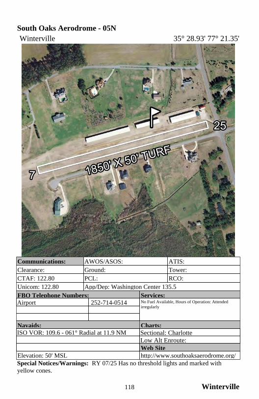
South Oaks Aerodrome - 05N
Winterville 35° 28.93' 77° 21.35'
AWOS/ASOS: ATIS:
Clearance: Ground: Tower:
CTAF: 122.80
Communications:
PCL: RCO:
Unicom: 122.80 App/Dep: Washington Center 135.5
FBO Telephone Numbers: Services:No Fuel Available, Hours of Operation: Attendedirregularly
Charts:Navaids:
Web SiteElevation: 50' MSL http://www.southoaksaerodrome.org/ RY 07/25 Has no threshold lights and marked withyellow cones.Special Notices/Warnings:
Winterville
Airport 252-714-0514
ISO VOR: 109.6 - 061° Radial at 11.9 NM Sectional: CharlotteLow Alt Enroute:
118

Lone Hickory Airport - 80C
Yadkinville 36° 03.63' 80° 41.41'
AWOS/ASOS: ATIS:
Clearance: Ground: Tower:
CTAF: 122.90
Communications:
PCL: RCO:
Unicom: 122.90 App/Dep: Greensboro 124.35
FBO Telephone Numbers: Services:No Fuel Available, Hours of Operation: Attendedirregularly
Charts:Navaids:
Web SiteElevation: 1015' MSL Winds permitting tkf Rwy 16 ldg Rwy 34, No flighttraining or student pilots, Rwy 16 has noise abatement procedure (See AFD).Special Notices/Warnings:
Yadkinville
Airport Information (336) 463-4680Airport Information (336) 463-2892
BZM VOR: 110.8 - 073° Radial at 29.1 NM Sectional: CincinnatiLow Alt Enroute:
119
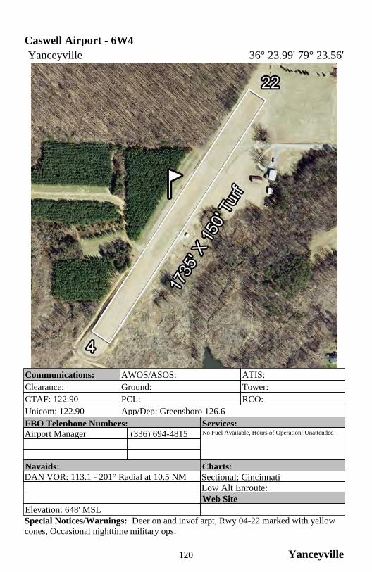
Caswell Airport - 6W4
Yanceyville 36° 23.99' 79° 23.56'
AWOS/ASOS: ATIS:
Clearance: Ground: Tower:
CTAF: 122.90
Communications:
PCL: RCO:
Unicom: 122.90 App/Dep: Greensboro 126.6
FBO Telephone Numbers: Services:No Fuel Available, Hours of Operation: Unattended
Charts:Navaids:
Web SiteElevation: 648' MSL Deer on and invof arpt, Rwy 04-22 marked with yellowcones, Occasional nighttime military ops.Special Notices/Warnings:
Yanceyville
Airport Manager (336) 694-4815
DAN VOR: 113.1 - 201° Radial at 10.5 NM Sectional: CincinnatiLow Alt Enroute:
120
Airports in this index are listed in alphabetical order by the airport name.
AIRPORT INDEX BY AIRPORT NAME
Air Harbor (W88)Greensboro 39
Albert J. Ellis Airport (OAJ)Jacksonville 50
Anson County Airport (AFP)Wadesboro 108
Ashe County Airport (GEV)Jefferson 51
Asheboro Regional Airport (HBI)Asheboro 15
Asheville Regional Airport (AVL)Asheville 16
Avery County/Morrison Field (7A8)Spruce Pine 101
Billy Mitchell Airport (HSE)Hatteras 42
Bladenboro Airport (3W6)Bladenboro 18
Burlington-Alamance Regional Airport (BUY)Burlington 19
Cape Fear Rgnl Jetport/Howie Franklin Fld (SUT)Oak Island 77
Caswell Airport (6W4)Yanceyville 120
Causey Airport (2A5)Liberty 59
Charlotte/Douglas International Airport (CLT)Charlotte 21
Charlotte-Monroe Executive Airport (EQY)Monroe 70
Clinton-Sampson County Airport (CTZ)Clinton 23
Coastal Carolina Regional Airport (EWN)New Bern 75
Columbus County Municipal Airport (CPC)Whiteville 113
Concord Regional Airport (JQF)Concord 24
Currituck County Regional Airport (ONX)Currituck 25
Curtis L. Brown, Jr. Field (EYF)Elizabethtown 28
Dare County Regional Airport (MQI)Manteo 65
Davidson County Airport (EXX)Lexington 58
Donald's Air Park (7NC)Plymouth 84
DS Butler Farm and Airfield (N83)Oak Ridge 78
Duplin County Airport (DPL)Kenansville 54
Elizabeth City CGAS/Regional Airport (ECG)Elizabeth City 27
Elkin Municipal Airport (ZEF)Elkin 29
Fayetteville Regional/Grannis Field (FAY)Fayetteville 33
First Flight Airport (FFA)Kill Devil Hills 55
Flanagan Field (N08)Farmville 32
Foothills Regional Airport (MRN)Morganton 72
Gastonia Municipal Airport (AKH)Gastonia 36
Goose Creek Airport (28A)Indian Trail 48
Grays Creek Airport (2GC)Fayetteville 34
Halifax-Northampton Regional Airport (IXA)Roanoke Rapids 91
Harnett Regional Jetport (HRJ)Erwin 31
PAGEAIRPORT NAME/IDENTIFIERCITY/TOWN
121

Henderson Field (ACZ)Wallace 109
Henderson-Oxford Airport (HNZ)Oxford 81
Hendersonville Airport (0A7)Hendersonville 43
Hiatt Airport (N97)Thomasville 107
Hickory Regional Airport (HKY)Hickory 45
Hinshaw (Greenacres) Airport (N61)Liberty 60
Holly Ridge/Topsail Island Airport (N21)Holly Ridge 46
Horace Williams Airport (IGX)Chapel Hill 20
Hurdle Field (4W7)Mebane 68
Hyde County Airport (7W6)Englehard 30
JAARS-Townsend Airport (N52)Waxhaw 112
Jackson County Airport (24A)Sylva 104
Johnston Regional Airport (JNX)Smithfield 100
Kecks Airport (N88)Julian 53
Kinston Regional Jetport at Stallings Field (ISO)Kinston 56
Lake Norman Airpark (14A)Mooresville 71
Laneys Airport (N92)Maiden 64
Laurinburg-Maxton Airport (MEB)Maxton 67
Lincolnton-Lincoln County Regional Airport (IPJ)Lincolnton 61
Lone Hickory Airport (80C)Yadkinville 119
Lumberton Regional Airport (LBT)Lumberton 63
Macon County Airport (1A5)Franklin 35
Martin County Airport (MCZ)Williamston 114
Meadow Brook Field (N63)Walnut Cove 110
Michael J. Smith Field (MRH)Beaufort 17
Montgomery County Airport (43A)Star 102
Moore County Airport (SOP)Pinehurst/Southern Pines 82
Mount Airy/Surry County Airport (MWK)Mount Airy 73
Mount Olive Municipal Airport (W40)Mount Olive 74
Northeastern Regional Airport (EDE)Edenton 26
Ocracoke Island Airport (W95)Ocracoke 80
Odell Williamson Municipal Airport (60J)Ocean Isle Beach 79
Person County Airport (TDF)Roxboro 94
Piedmont Triad International Airport (GSO)Greensboro 38
Pink Hill Airport (4W9)Pink Hill 83
Pitt-Greenville Airport (PGV)Greenville 41
PK Airpark (5W4)Raeford 86
Plymouth Municipal Airport (PMZ)Plymouth 85
Raleigh East Airport (W17)Knightdale 57
PAGEAIRPORT NAME/IDENTIFIERCITY/TOWN
122

Raleigh Exec. Jetport at Sanford-Lee County (TTA)Sanford 97
Raleigh-Durham International Airport (RDU)Raleigh 88
Richmond County Airport (RCZ)Rockingham 92
Rockingham County-NC Shiloh Airport (SIF)Reidsville 89
Rocky Mount-Wilson Regional Airport (RWI)Rocky Mount 93
Rowan County Airport (RUQ)Salisbury 96
Rutherford County-Marchman Field (FQD)Rutherfordton 95
Shelby-Cleveland County Regional (EHO)Shelby 98
Shiflet Field (9A9)Marion 66
Siler City Municipal Airport (SCR)Siler City 99
Sky Manor Airport (N22)Jacksonville 49
Smith Reynolds Airport (INT)Winston-Salem 117
South Oaks Aerodrome (05N)Winterville 118
Southeast Greensboro (3A4)Greensboro 40
Stanly County Airport (VUJ)Albemarle 13
Statesville Regional Airport (SVH)Statesville 103
Swan Creek Airport (78A)Jonesville 52
Tarboro-Edgecombe Airport (ETC)Tarboro 105
Taylorsville Airport (NC2)Taylorsville 106
Triangle North Executive Airport (LHZ)Louisburg 62
Tri-County Airport (ASJ)Ahoskie 12
Triple W Airport (5W5)Raleigh 87
Twin Lakes Airport (8A7)Mocksville 69
Warf Airport (6A5)Reidsville 90
Warren Field (OCW)Washington 111
Wayne Executive Jetport (GWW)Goldsboro 37
Western Carolina Regional (RHP)Andrews 14
Whitfield Farms Airport (4W4)Hurdle Mills 47
Wilgrove Air Park (8A6)Charlotte 22
Wilkes County Airport (UKF)North Wilkesboro 76
Wilmington International Airport (ILM)Wilmington 115
Wilson Industrial Air Center (W03)Wilson 116
Wilson's Airport (E40)Hickory 44
PAGEAIRPORT NAME/IDENTIFIERCITY/TOWN
123

PRIVATE AIRPORTS
ADAMS AIRPORT
8NC5
34-34-33.9960N 079-14-55.7160W
ROWLAND, ROBESON CO.
910-422-8181
01/19 3600 x 80 TURF
AERO PLANTATION AIRPORT
NC21
34-59-30.5160N 080-44-54.2400W
WEDDINGTON, UNION CO.
704-843-5338 123.00
06/24 2400 x 60 ASPH
ALEXANDER COUNTY AIRPORT
NC59
35-51-2.4480N 081-08-38.2920W
TAYLORSVILLE, ALEXANDER CO.
828-632-8635
09/27 2700 x 50 TURF-G
ARANT AIRPORT
1NC6
35-03-21.5280N 080-27-0.2160W
WINGATE, UNION CO.
704-283-1714 122.80
15/33 2800 x 70 TURF
ATWELL AIRPORT
1NC2
35-39-16.9920N 080-47-21.9840W
MOORESVILLE, IREDELL CO.
704-664-7506
18/36 1700 x 60 TURF
BAGWELL AIRPORT
NC99
35-40-27.5520N 078-36-25.9920W
GARNER, WAKE CO.
919-772-0499
12/30 2200 x 100 TURF
BAHNSON GLIDERPORT
43NC
36-01-14.9880N 080-30-58.9680W
MOCKSVILLE, DAVIE CO.
336-998-3160
01/19 3000 x 100 TURF
BALL AIRPORT
79NC
36-08-3.5160N 078-16-54.9480W
LOUISBURG, FRANKLIN CO.
919-496-3584 122.80
18/36 2459 x 40 ASPH-F
BALLOONPORT OF GREENSBORO
28NC
35-57-20.9880N 079-49-7.9680W
GREENSBORO, GUILFORD CO.
336-299-6717
B1 1000 x 1000 TURF
BARCLAYSVILLE FIELD
NC44
35-28-0.9840N 078-41-1.9680W
ANGIER, HARNETT CO.
919-876-2468
05/23 2300 x 100 TURF
BARRINGER FIELD
NC64
35-31-39.9720N 080-41-47.9760W
KANNAPOLIS, ROWAN CO.
704-786-3375
10/28 2000 x 80 TURF
BAY CREEK AIRPORT
4NC2
35-12-27.5760N 076-36-43.7040W
BAYBORO, PAMLICO CO.
252-745-3521
09/27 2000 x 150 TURF
BEAR CREEK AIRPORT
NC79
35-24-25.4880N 080-21-27.2160W
MOUNT PLEASANT, CABARRUS CO.
704-436-6894
03/21 2025 x 85 TURF-F
BELL MOUNTAIN AIRPORT
08NR
35-13-3.9720N 082-25-33.9960W
ZIRCONIA, HENDERSON CO.
828-693-7656
02/20 1400 x 40 TURF-G
BELL STRIP AIRPORT
1NC4
34-59-43.5480N 077-15-27.8280W
POLLOCKSVILLE, JONES CO.
252-224-6376
17/35 3000 x 75 TURF
BENTON FARM AIRPORT
74NC
35-05-46.9680N 076-37-46.9920W
WHARTONVILLE, PAMLICO CO.
252-249-0464
17/35 2000 x 150 TURF
BERTS AIRPORT
NC32
36-01-32.9880N 080-26-10.9680W
CLEMMONS, DAVIE CO.
336-998-3160
14/32 2500 x 150 TURF
BLACKWATER AIRSTRIP
NC61
36-27-33.9840N 076-12-38.9880W
MOYOCK, CAMDEN CO.
252-435-2488
10/28 2150 x 90 CONC
BOOMERANG AIRPORT
NC02
35-12-45.4320N 081-51-59.3640W
HARRIS, RUTHERFORD CO.
828-245-1462
16/34 2000 x 75 TURF-DIRT-P
BOONE INC AIRPORT
NC14
36-11-48.4440N 081-38-22.3800W
BOONE, WATAUGA CO.
828-265-3598 122.80
13/31 2100 x 40 ASPH
124

BOONVILLE AIRPORT
26NC
36-13-22.4760N 080-42-56.2320W
BOONVILLE, YADKIN CO.
336-367-7958
01/19 1500 x 50 TURF-G
BOYD FIELD
NC49
35-31-39.9720N 077-11-47.9760W
GRIMESLAND, PITT CO.
919-363-9876
18/36 1400 x 100 TURF
BOYD'S HAWKS CREEK AIRPORT
4NC0
35-53-54.4920N 080-36-58.2120W
MOCKSVILLE, DAVIE CO.
336-492-2080
11/29 2000 x 60 TURF
BRADFORD FIELD AIRPORT
NC05
35-24-31.5000N 080-47-39.2280W
HUNTERSVILLE, MECKLENBURG CO.
704-578-4039
06/24 3850 x 150 TURF
BRADLEY FIELD
NC29
35-37-12.4680N 080-35-51.2160W
CHINA GROVE, ROWAN CO.
704-279-7683
18/36 2200 x 50 TURF
BREVARD AIRPORT
NC16
35-13-21.3960N 082-43-36.4440W
BREVARD, TRANSYLVANIA CO.
828-884-9011
04/22 2100 x 50 TURF
BROADWAY AIRFIELD
44NC
35-32-35.9880N 080-39-6.9840W
LANDIS, ROWAN CO.
704-933-0308
09/27 2200 x 200 TURF
BROOKS FIELD
8NC6
35-41-22.4880N 079-24-25.0560W
SILER CITY, CHATHAM CO.
919-742-3423
08/26 2200 x 75 TURF
BROWN AIRPORT
6NC4
35-54-20.4480N 081-08-22.2720W
TAYLORSVILLE, ALEXANDER CO.
828-632-5444
06/24 1400 x 40 TURF16/34 1200 x 40 TURF
BROWN FIELD
46NC
34-53-33.9720N 080-22-23.9880W
MARSHVILLE, UNION CO.
704-624-1924 122.80
09/27 1500 x 300 TURF
BUFFALO CREEK AIRPORT
4NC8
35-25-20.4960N 080-37-14.2320W
CONCORD, CABARRUS CO.
704-723-9450
15/33 2600 x 75 TURF
BUIE FIELD
9NR8
34-47-35.9880N 079-11-36.9960W
RED SPRINGS, ROBESON CO.
910-258-9377
06/24 2780 x 50 TURF13/31 2700 x 50 TURF
CANAAN AIR BASE
NC20
35-05-23.4960N 077-10-14.9880W
NEW BERN, CRAVEN CO.
09/27 1840 x 40 ASPH
CANE CREEK AIRPORT
4NC6
35-26-40.4160N 082-28-46.4160W
FLETCHER, HENDERSON CO.
828-684-6441
04/22 2680 x 160 TURF
CHALFANT AIRPORT
NC77
35-27-20.4840N 080-34-32.2320W
CONCORD, CABARRUS CO.
704-782-6660
01/19 2700 x 100 TURF
CHARLES FIELD
NC22
35-13-39.1080N 078-33-18.6480W
DUNN, SAMPSON CO.
910-892-5494
13/31 1000 x 50 TURF
CIRCLE P FARM AIRPORT
6NC7
34-45-4.9680N 076-54-21.9960W
NEWPORT, CARTERET CO.
252-223-5119
05/23 3000 x 80 ASPH-TURF
CLUTE'S HILLTOP AIRPORT
69NC
35-26-2.4360N 081-51-4.3560W
FOREST CITY, RUTHERFORD CO.
828-287-9224
08/26 2200 x 120 TURF
CLYDE VALLEY AIRPORT
3NC0
35-41-25.4400N 081-42-44.3160W
MORGANTON, BURKE CO.
828-433-0015
16/34 1750 x 50 TURF
CORRIHER FIELD
88NC
35-37-57.0000N 080-41-6.9720W
SALISBURY, ROWAN CO.
704-630-6988
18/36 2000 x 40 TURF
125

COTTON GIN AIRFIELD
NC36
35-30-10.5480N 078-01-48.9360W
PIKEVILLE, WAYNE CO.
919-242-6303
07/25 1825 x 70 TURF-G16/34 1030 x 70 TURF-G
COX AIRPORT
NC81
35-45-6.5160N 078-51-34.9920W
APEX, WAKE CO.
919-427-3090
09/27 2450 x 75 TURF
COX FIELD
81NC
34-02-26.9880N 078-44-24.0000W
TABOR CITY, COLUMBUS CO.
910-653-2403
04/22 3300 x 50 TURF-GRVL-G
COX-GRANTHAM AIRFIELD
6NC0
35-17-20.5800N 078-10-47.9640W
GRANTHAM, WAYNE CO.
919-689-2737
03/21 2800 x 54 TURF
CRAIG CRAFT AIRPORT
86NC
36-15-48.9960N 076-29-35.9880W
HERTFORD, WASHINGTON CO.
252-426-2676
04/22 2900 x 100 TURF
CROOKED CREEK AIRPORT
7NC5
35-56-1.5360N 078-14-47.9760W
BUNN, FRANKLIN CO.
919-215-3151
04/22 2500 x 80 TURF
DARR FIELD
NC03
35-54-30.4560N 079-59-14.1360W
HIGH POINT, RANDOLPH CO.
336-431-9158
13/31 2700 x 60 TURF-GRVL-G
DEAD DOG AIRPORT
8NC4
35-43-47.4960N 079-18-46.0440W
PITTSBORO, CHATHAM CO.
919-742-4866
16/34 2000 x 60 TURF-F
DEAN WINGS PAST AIRPORT
8NC1
35-22-34.5360N 079-14-27.0600W
CAMERON, LEE CO.
919-775-7810
06/24 2400 x 150 TURF
DECK AIRPARK
NC11
35-44-29.5080N 078-55-29.0280W
APEX, WAKE CO.
919-387-0641
04/22 1950 x 100 TURF
DEER RUN AIRPORT
NC56
36-12-16.9920N 078-28-7.9680W
KITTRELL, VANCE CO.
252-432-3096
12/30 1600 x 100 TURF
DELK'S AIRPORT
1NC0
35-43-19.4880N 079-56-29.1120W
ASHEBORO, RANDOLPH CO.
336-229-0991
16/34 2300 x 46 TURF
DILLARD AIRPORT
54NC
36-14-21.9840N 076-25-1.9920W
WINFALL, PERQUIMANS CO.
252-426-9676
07/25 2700 x 85 TURF
DIRT DOBBER'S GRASS STRIP AIRPORT
NC97
35-22-7.9680N 081-31-21.0000W
SHELBY, CLEVELAND CO.
704-538-0095
08/26 1600 x 100 TURF
DOGWOOD FARM AIRPORT
NC87
34-52-54.5520N 076-56-33.7920W
HAVELOCK, CRAVEN CO.
252-671-2695
01/19 1400 x 125 TURF
DOUBLE CREEK RANCH AIRPORT
0NC8
35-45-20.4840N 080-44-7.2240W
CLEVELAND, ROWAN CO.
704-278-9291
03/21 2300 x 100 TURF
DOUBLE S AIRPORT
19NC
36-03-53.5320N 077-55-22.9080W
RED OAK, NASH CO.
252-937-4201
17/35 2400 x 100 TURF
DRAGONFLY FIELD
15NC
36-14-22.9920N 076-58-25.9680W
AHOSKIE, HERTFORD CO.
252-332-7690
14/32 1800 x 50 TURF
DUBLIN FIELD
NC82
34-40-10.5960N 078-42-9.0360W
DUBLIN, BLADEN CO.
910-862-4165
03/21 2186 x 66 TURF
DUNROAMIN FARMS AIRPORT
76NC
36-09-35.5320N 077-37-28.8840W
ENFIELD, HALIFAX CO.
252-445-5602
03/21 3000 x 70 TURF
126

E T FIELD
NC71
34-55-4.5840N 079-03-9.1080W
PARKTON, ROBESON CO.
910-425-9115
01/19 2300 x 100 TURF
EAGLES LANDING AIRPORT
9NC8
35-41-12.7680N 079-13-7.6800W
PITTSBORO, CHATHAM CO.
919-783-9468
01/19 3800 x 80 TURF-P
EAGLES NEST AIRPORT
6N9Closed
34-58-55.7760N 077-41-54.6000W
POTTERS HILL, DUPLIN CO.
122.90
EASTOVER AIR RANCH AIRPORT
6NC3
35-05-10.9680N 078-46-19.9920W
FAYETTEVILLE, CUMBERLAND CO.
910-483-7649
04/22 3000 x 300 TURF
EDWARDS AIRPORT
9NC3
35-04-14.9880N 080-33-58.9680W
MONROE, UNION CO.
704-283-4240
06/24 2650 x 100 TURF
ELK RIVER AIRPORT
NC06
36-09-37.4400N 081-53-48.4080W
BANNER ELK, AVERY CO.
828-898-9791 122.90
12/30 4600 x 75 ASPH
ELKINS FIELD
2NR2
34-27-27.9720N 078-37-5.9880W
CLARKTON, BLADEN CO.
910-876-0908
01/19 2000 x 75 TURF
ENFIELD-SHEARIN AIRPORT
NC45
36-13-1.9920N 077-38-15.0000W
ENFIELD, HALIFAX CO.
252-445-2406
03/21 3200 x 75 TURF
ENOCHVILLE AIRPORT
NC39
35-31-27.4800N 080-38-52.2240W
KANNAPOLIS, ROWAN CO.
704-932-4486
13/31 2600 x 100 TURF
EPLEY AIRPORT
52NC
34-50-40.5960N 077-15-59.9760W
JACKSONVILLE, ONSLOW CO.
910-455-5491
07/25 2400 x 75 TURF
ERVIN AIRFIELD
50NC
35-32-42.0000N 080-40-6.9960W
KANNAPOLIS, ROWAN CO.
704-933-2141
17/35 2450 x 90 TURF
FIELDS AIRPORT
64NC
35-54-6.9840N 079-46-21.0000W
PLEASANT GARDEN, RANDOLPH CO.
336-674-2202
01/19 1800 x 50 TURF
FLETCHER'S AIRPORT
1NC3
36-10-50.5560N 076-08-56.7240W
ELIZABETH CITY, PASQUOTANK CO.
252-330-4710
09/27 2500 x 100 TURF
FLYERS AIRPARK
9NC2
35-13-5.5560N 078-47-47.0760W
LINDEN, CUMBERLAND CO.
910-980-0340
04/22 2850 x 65 TURF
FLYING BJ AIRPORT
3NC5
35-48-43.9920N 081-04-12.0000W
STONY POINT, IREDELL CO.
704-880-1663
18/36 2000 x 75 TURF
FLYING DOVE FIELD
22NC
35-49-15.9960N 079-28-5.9880W
SILER CITY, CHATHAM CO.
919-663-3304
18/36 2500 x 100 TURF-P
FLYING M AIRPORT
2NC6
35-47-58.4880N 080-23-46.1760W
LEXINGTON, DAVIDSON CO.
336-956-6227
18/36 1780 x 200 TURF
FOX HAVEN PLANTATION AIRPORT
58NC
35-20-48.4080N 082-03-18.3600W
RUTHERFORDTON, RUTHERFORD CO.
828-286-0038
09/27 2000 x 80 TURF-P
FUQUAY/ANGIER FIELD
78NC
35-32-39.5520N 078-44-51.0360W
FUQUAY/VARINA, WAKE CO.
919-639-0806 122.80
14/32 2780 x 90 TURF-G
GILLIAM - MCCONNELL AIRFIELD
5NC3
35-20-29.9760N 079-26-12.9840W
CARTHAGE, MOORE CO.
910-947-3636
13/31 2538 x 36 ASPH-G
127

GLOVER AIRPORT
45NC
36-31-40.9800N 077-27-16.9920W
SEABOARD, NORTHAMPTON CO.
252-589-1012
07/25 1750 x 50 TURF
GOLD HILL AIRPORT
NC25
35-30-32.4720N 080-18-40.1760W
GOLD HILL, ROWAN CO.
704-279-6807 122.90
09/27 3000 x 30 ASPH
GOODNIGHT'S AIRPORT
2NC8
35-31-31.4760N 080-38-23.2080W
KANNAPOLIS, ROWAN CO.
704-933-2639
07/25 1300 x 100 TURF
GREENSBORO NORTH AIRPORT
36NC
36-15-12.9960N 079-54-28.9800W
GREENSBORO, GUILFORD CO.
336-643-0124
05/23 3200 x 32 ASPH-TURF
GRYDER-TEAGUE AIRPORT
NC58
35-55-15.4560N 081-07-12.2880W
TAYLORSVILLE, ALEXANDER CO.
828-632-4610
09/27 2000 x 60 TURF
HALL FIELD
32NC
34-53-46.9680N 079-02-34.9800W
PARKTON, ROBESON CO.
910-858-3430
03/21 2000 x 200 TURF
HAPPY BOTTOM
30NC
36-02-54.9960N 080-27-40.7880W
ADVANCE, DAVIE CO.
336-940-2451
16/34 2700 x 50 TURF
HARVEY POINT DEFENSE TESTING ACTIVITY
NC01
36-05-46.3920N 076-19-37.3800W
HERTFORD, PERQUIMANS CO.
252-426-5221
03/21 5291 x 100 ASPH-G
HAWK'S KNOLL AIRPORT
2NC1
34-59-50.5320N 080-48-3.2400W
WAXHAW, UNION CO.
704-843-3437
14/32 1800 x 100 TURF
HAWKS MEADOW AIRPORT
07NC
34-49-59.5200N 080-45-4.2120W
WAXHAW, UNION CO.
704-843-1085
08/26 2000 x 50 TURF
HICKORY HILL AIRPORT
62NC
34-56-12.5520N 076-56-40.7760W
HAVELOCK, CRAVEN CO.
252-447-7122
04/22 2200 x 100 ASPH-TURF
HIGHTOWER AREO PLANTATION AIRPORT
67NC
34-58-12.0000N 080-01-43.9680W
WADESBORO, ANSON CO.
704-694-3185
18/36 3000 x 100 TURF
HINTON FIELD
NC72
35-27-5.5800N 078-09-35.9640W
PRINCETON, JOHNSTON CO.
919-936-3501
05/23 2000 x 35 TURF
HODGES FARM AIRPORT
NC73
35-26-19.5720N 076-26-57.6960W
SLADESVILLE, HYDE CO.
252-986-2230
01/19 2750 x 75 TURF
HOLEMAN FIELD
NC40
36-29-58.9920N 079-07-6.9960W
ROXBORO, PERSON CO.
36-2234-8531
04/22 1700 x 50 TURF
HOOD FIELD
66NC
35-10-27.9840N 077-29-0.9960W
DOVER, JONES CO.
252-520-4800
10/28 2800 x 70 TURF
JACKSON PRIVATE AIRPORT
NC54
34-52-39.5760N 076-21-23.6880W
ATLANTIC, CARTERET CO.
252-447-7122
01/19 3000 x 100 TURF
JILES FIELD
9NC4
36-30-33.9840N 076-39-50.9760W
GATES, GATES CO.
252-465-2169
18/36 2000 x 40 TURF
JOHNSTON AIRPORT
35NC
35-32-17.9880N 080-45-4.9680W
MOORESVILLE, IREDELL CO.
704-799-8098
16/34 2100 x 100 TURF
JOHNSTON FARM AIRPORT
10NC
36-20-34.9800N 077-30-33.9840W
JACKSON, NORTHAMPTON CO.
252-583-4151
13/31 2450 x 80 TURF
128

JORDAN FIELD
NR02
35-14-15.9720N 079-59-43.9800W
MOUNT GILEAD, MONTGOMERY CO.
910-439-6121
04/22 3900 x 70 TURF
JW STONE AIRPORT
75NC
35-50-57.5520N 078-11-0.9600W
MIDDLESEX, NASH CO.
252-235-4794
15/33 1600 x 100 TURF
K & D AIRPORT
71NC
36-15-47.9880N 079-26-58.9920W
ELON COLLEGE, CASWELL CO.
336-421-5920
04/22 3000 x 200 TURF09/27 1000 x 200 TURF
KENLY AIRPORT
7NC3
35-35-46.9680N 078-05-54.9960W
KENLY, JOHNSTON CO.
919-284-4636
09/27 3480 x 100 TURF
LAKE RIDGE AERO PARK
8NC8
36-03-36.5040N 078-46-59.9880W
DURHAM, DURHAM CO.
919-688-6358
14/32 3200 x 150 TURF
LANNI FIELD AIRPORT
18NC
35-53-20.4360N 081-36-49.3200W
LENOIR, CALDWELL CO.
828-754-4944
03/21 750 x 50 TURF
LARRY F WARREN FIELD
29NC
35-18-41.9760N 081-37-30.9720W
SHELBY, CLEVELAND CO.
704-434-7435
11/29 2200 x 100 TURF-G
LEE CREEK AIRPORT
NC12
35-23-22.5960N 076-47-4.7400W
AURORA, BEAUFORT CO.
252-322-8147
08/26 5070 x 75 ASPH
LEE'S AIRPORT
16NC
36-11-45.9960N 076-39-54.9720W
EDENTON, CHOWAN CO.
252-221-4487
01/19 1524 x 66 TURF10/28 2600 x 100 TURF
LEWIS AIRSTRIP
7NC7
36-20-48.4800N 080-10-25.1400W
WALNUT COVE, STOKES CO.
336-593-9213
10/28 1700 x 40 TURF
LINDSAY AIRPORT
0NC7
36-21-25.9920N 079-59-51.0000W
MADISON, ROCKINGHAM CO.
336-548-2223
03/21 1700 x 75 TURF
LITTLE MOUNTAIN AIRPORT
6NC1
35-35-30.4800N 081-04-46.2720W
DENVER, CATAWBA CO.
866-584-5423
03/21 3000 x 40 ASPH-G
LONESOME FIELD
1NC8
35-30-56.9880N 080-15-28.9800W
RICHFIELD, ROWAN CO.
704-279-8182
01/19 2250 x 150 TURF
LONG ISLAND AIRPORT
NC26
35-39-39.4560N 080-58-14.2680W
LONG ISLAND, CATAWBA CO.
877-359-6226
05/23 3000 x 100 TURF
LOWER CREEK AIRPORT
NC27
35-56-40.4520N 081-29-24.3240W
LENOIR, CALDWELL CO.
828-758-4524
05/23 3200 x 150 TURF
LZ CARROLL AIRPORT
4NC9
35-26-54.6000N 080-20-33.2880W
GOLD HILL, CABARRUS CO.
704-906-1838
10/28 900 x 50 TURF
MARCHMONT PLANTATION AIRPARK
6NC8
35-56-17.4840N 080-23-4.1640W
ADVANCE, DAVIE CO.
336-998-2600
06/24 2500 x 60 TURF
MARTINDALE EXECUTIVE AIRPARK
70NC
36-32-40.4880N 078-08-52.9440W
PASCHALL, MECKLENBURG CO.
919-779-8649
09/27 3000 x 75 TURF
MASSENGILL AIRPORT
NC76
35-19-4.5840N 078-23-16.0080W
NEWTON GROVE, JOHNSTON CO.
919-894-2343
09/27 1800 x 100 TURF
MAXWELL AIRPORT
3NC7
36-31-9.4440N 081-08-12.3000W
SPARTA, ALLEGHANY CO.
336-372-5315
17/35 1300 x 60 TURF
129

MCCACHREN FIELD
3NC6
35-18-42.4800N 080-38-39.2280W
HARRISBURG, CABARRUS CO.
704-455-2754 122.80
09/27 2300 x 23 TURF
MCDONALD FIELD
3NC4
35-03-12.5280N 080-24-32.2200W
MARSHVILLE, UNION CO.
704-309-6264
03/21 4000 x 100 TURF
MCGEE FIELD
24NC
35-07-37.9920N 080-28-30.0000W
MONROE, UNION CO.
704-372-7610
09/27 2500 x 60 CONC-TURF
MCKEE AIRPORT
NC70
34-30-17.5680N 079-06-9.1080W
FAIRMONT, ROBESON CO.
910-628-0926
18/36 3300 x 80 TURF-G
MCLEAN BROTHERS AIRPORT
59NC
36-05-50.4600N 079-33-19.0800W
GIBSONVILLE, GUILFORD CO.
336-449-7346 122.80
06/24 2200 x 170 TURF-G
MEADSTOWN AIRSTRIP
NC28
36-12-0.5400N 076-14-8.7360W
ELIZABETH CITY, PASQUOTANK CO.
252-330-4103
N/S 3600 x 150 TURF
MEYLOR FIELD
9NC9
36-12-36.4680N 079-53-42.1080W
GREENSBORO, GUILFORD CO.
336-852-2222
09/27 1500 x 50 TURF
MILES AIRPORT
NC34
35-58-13.4760N 079-07-29.0280W
CHAPEL HILL, ORANGE CO.
919-967-5458
09/27 2500 x 120 TURF
MILLER AIR PARK
NC30
35-36-50.4720N 080-44-29.2200W
MOORESVILLE, ROWAN CO.
704-664-2831
18/36 2060 x 100 TURF-F
MITCHELL FIELD
17NC
34-27-58.5720N 078-19-42.9960W
ELIZABETHTOWN, BLADEN CO.
910-669-2045
15/33 2100 x 90 TURF
MORETZ RIVERSIDE LANDING AIRPORT
NC00
35-33-36.0000N 079-11-36.9960W
SANFORD, LEE CO.
919-774-6055
18/36 2000 x 24 ASPH
MORRISON FIELD
48NC
35-46-53.9760N 080-25-0.9840W
LEXINGTON, DAVIDSON CO.
336-752-2710
05/23 1200 x 200 TURF
MOSS HILL AIRPORT
6NC9
35-12-7.5600N 077-45-1.9080W
KINSTON, LENOIR CO.
252-569-8161
01/19 3000 x 60 TURF13/31 1000 x 100 TURF
MOUNTAIN AIR AIRPORT
2NC0
35-52-7.3920N 082-20-30.4440W
BURNSVILLE, YANCEY CO.
828-682-5600 122.70
14/32 2900 x 50 ASPH
MOUNTAIN VIEW AERODROME
NC37
36-20-24.4680N 079-50-28.1040W
REIDSVILLE, ROCKINGHAM CO.
336-342-5322
12/30 2000 x 50 TURF
MOUNTAIN VIEW AIRPORT
20NC
35-35-32.4600N 081-03-21.2760W
SHERRILLS FORD, CATAWBA CO.
704-483-4330
03/21 2000 x 50 TURF
MYNATT FIELD AIRPORT
53NC
34-22-40.9800N 079-04-49.9800W
LUMBERTON, ROBESON CO.
336-748-8611
08/26 2000 x 40 TURF
NOCARVA AIRPORT
NC10
36-32-30.5160N 078-03-28.9440W
MACON, WARREN CO.
252-257-2881
18/36 1900 x 100 TURF-F
NORTH RALEIGH AIRPORT
00NC
36-05-6.5400N 078-22-16.9680W
LOUISBURG, FRANKLIN CO.
919-496-2224
05/23 2650 x 36 ASPH-G
NORTHBROOK INTERNATIONAL ULTRAPORT
1NC9
35-26-58.9920N 081-25-34.9680W
CHERRYVILLE, LINCOLN CO.
704-435-4931
08/26 1200 x 75 TURF
130

PAMLICO AIRPORT
7NC0
35-09-30.6000N 076-45-45.7200W
BAYBORO, PAMLICO CO.
252-745-3157
18/36 2900 x 75 TURF
PARKER FIELD
8NC7
34-56-10.9680N 077-16-35.9760W
MAYSVILLE, JONES CO.
910-743-9301
03/21 2200 x 75 TURF
PEACOCK AIRPORT
4NC7
35-41-46.5360N 078-32-15.0000W
GARNER, WAKE CO.
919-772-7329
18/36 1700 x 75 TURF
PETTIGREW MOORE AERODROME
33NC
34-25-36.9840N 078-05-21.9840W
WILMINGTON, PENDER CO.
910-763-1941
18/36 1800 x 150 TURF
PHILIP R BUNN AIRPORT
51NC
35-51-42.9840N 078-20-54.9960W
ZEBULON, WAKE CO.
919-269-7349
10/28 2300 x 100 TURF
PILOTS RIDGE AIRPORT
03NC
34-06-15.5880N 077-54-14.9760W
CAROLINA BEACH, NEW HANOVER CO.
910-313-6950 122.80
09/27 3000 x 40 ASPH-G
PINE ISLAND AIRPORT
7NC2
36-15-12.5640N 075-47-18.6720W
COROLLA, CURRITUCK CO.
919-840-4443
17/35 3450 x 55 ASPH
PINEVIEW AIR AIRPORT
82NC
35-18-28.9800N 079-04-23.9880W
SANFORD, HARNETT CO.
919-499-9900
13/31 1400 x 60 TURF
PINEY RIDGE AIRPORT
NC42
36-04-19.4520N 080-41-59.2080W
YADKINVILLE, YADKIN CO.
336-463-2303
18/36 1700 x 60 TURF
PROPST AIRPORT
NC19
35-23-30.4800N 080-34-32.2320W
CONCORD, CABARRUS CO.
704-786-6322
04/22 3400 x 50 ASPH
QUIET ACRES AIRPORT
NC31
35-45-53.4600N 080-01-27.1200W
THOMASVILLE, RANDOLPH CO.
336-475-4495
09/27 1800 x 75 TURF
RAEFORD RHYNE AIRPARK
NC15
35-57-25.4520N 080-58-44.2560W
STATESVILLE, IREDELL CO.
704-873-2871
02/20 2500 x 200 TURF-G
REAGANS ROOST ULTRALIGHT
85NC
35-25-45.0840N 083-10-0.4080W
WHITTIER, JACKSON CO.
828-497-2074
01/19 800 x 70 TURF
RILEY FIELD
1NC5
35-55-59.4840N 078-20-54.8880W
BUNN, FRANKLIN CO.
919-269-7985
09/27 2000 x 75 TURF
ROBERTSON FIELD
NC63
36-08-6.4680N 080-11-5.1360W
WINSTON SALEM, FORSYTH CO.
336-725-4447
03/21 1500 x 100 TURF
ROCKING A FARM AIRPORT
NC86
34-44-0.9960N 078-45-10.9800W
WHITE OAK, BLADEN CO.
910-866-5267
05/23 3300 x 25 ASPH
RON'S ULTRALIGHT FIELD
1NC1
35-48-42.9840N 079-14-18.9960W
PITTSBORO, CHATHAM CO.
919-545-9595
14/32 1600 x 125 TURF
ROOSTER FIELD AIRPORT
84NC
35-16-23.9880N 079-14-54.9960W
CAMERON, MOORE CO.
910-286-6854
09/27 2155 x 132 TURF
SAFE FIELD
NC48
34-45-0.5760N 078-03-35.9280W
WALLACE, DUPLIN CO.
910-285-7915
10/28 3000 x 70 TURF
SCHNEIDER HAVEN AIRSTRIP
NC75
35-53-53.9880N 080-43-12.9720W
HARMONY, IREDELL CO.
704-546-7058
17/35 1200 x 60 TURF
131

SCOTLAND NECK EAST AIRPORT
2NC7
36-10-4.5480N 077-23-55.8600W
SCOTLAND NECK, HALIFAX CO.
252-826-5164
18/36 3000 x 100 TURF
SCOTTBROOK FARM AIRPORT
2NC4
35-20-16.5840N 078-09-16.9560W
GOLDSBORO, WAYNE CO.
919-689-9554
01/19 1350 x 40 TURF
SILVER CREEK AIRPORT
NC52
35-43-42.4560N 081-43-44.3280W
MORGANTON, BURKE CO.
828-584-1446
09/27 3600 x 200 TURF
SIX OAKS AIRPORT
NC67
35-28-3.9720N 082-27-9.0000W
ASHEVILLE, BUNCOMBE CO.
828-628-1549
06/24 2600 x 100 TURF
SKYLAND AIRPORT
NC50
36-27-36.4320N 081-21-41.3280W
JEFFERSON, ASHE CO.
336-982-3713
10/28 1460 x 20 ASPH
SLOOP AIRPORT
41NC
35-31-18.4800N 080-31-19.2000W
KANNAPOLIS, ROWAN CO.
704-857-9573
04/22 2000 x 100 TURF
SMITH AIR STRIP
25NC
35-37-59.9880N 079-42-36.0000W
ASHEBORO, RANDOLPH CO.
336-879-5440
18/36 3100 x 60 TURF-G
SOSSAMON FIELD
57NC
35-25-35.3280N 083-27-29.5560W
BRYSON CITY, SWAIN CO.
828-488-2450
10/28 2265 x 50 ASPH
SOUTH RIVER AIRPORT
NC93
35-46-39.9720N 080-30-4.9680W
SALISBURY, ROWAN CO.
704-633-8013
07/25 1850 x 50 TURF
SOUTHERN COMFORTS AERODROME
61NC
34-52-16.5720N 078-57-56.0880W
PARKTON, ROBESON CO.
910-858-2206 122.80
01/19 4000 x 200 TURF
SOUTHERN SKIES ULTRALIGHT
NR04
35-57-36.9720N 081-10-22.9800W
TAYLORSVILLE, ALEXANDER CO.
828-632-6000
02/20 1100 x 60 TURF-G07/25 1600 x 60 TURF
SPENCER AIRPORT
NC35
35-24-10.4760N 080-37-19.2360W
CONCORD, CABARRUS CO.
704-786-5160 122.80
03/21 2180 x 75 TURF-GRVL
SPENCER FIELD
7NC9
35-43-38.4600N 079-54-40.1040W
ASHEBORO, RANDOLPH CO.
336-629-0097
17/35 1400 x 75 TURF
SPRING PATHS AIRPORT
42NC
35-57-27.9720N 078-10-13.9800W
SPRING HOPE, FRANKLIN CO.
252-478-4567
17/35 1200 x 50 TURF
STAG AIR PARK
7NC1
34-31-40.5840N 077-51-0.7200W
BURGAW, PENDER CO.
910-675-3927
11/29 4000 x 125 TURF
STAR HILL GOLF CLUB AIRPORT
60NC
34-42-18.5760N 077-03-3.7800W
CAPE CARTERET, CARTERET CO.
252-393-8111
06/24 2800 x 75 TURF-F
STONERIVER AIRPORT
NC09
35-53-1.9680N 080-46-35.9760W
STATESVILLE, IREDELL CO.
704-924-7830
16/34 2000 x 120 TURF
STRICKLAND FIELD
89NC
34-15-58.9680N 079-01-24.9960W
FAIR BLUFF, COLUMBUS CO.
910-649-7133
05/23 2642 x 118 TURF
SUGAR VALLEY AIRPORT
5NC2
35-59-7.1880N 080-30-40.1760W
MOCKSVILLE, DAVIE CO.
123.00
02/20 2424 x 36 ASPH-G
SUMMEY AIRPARK
8NC2
35-17-21.4080N 081-47-6.3600W
CAROLEEN, RUTHERFORD CO.
864-461-3888
14/32 2500 x 120 TURF
132

TAILWINDS AIRPORT
06NC
34-49-39.0000N 078-55-48.9720W
ST. PAULS, ROBESON CO.
910-488-1420
09/27 2600 x 90 TURF
TARA AIRBASE AIRPORT
5NC1
35-47-35.4840N 080-30-44.2080W
MOCKSVILLE, DAVIE CO.
122.80
18/36 2100 x 75 TURF
THE DUCHY AIRPORT
5NC5
35-58-53.4720N 079-16-23.0520W
CHAPEL HILL, ALAMANCE CO.
336-516-0644
03/21 3500 x 44 ASPH
THOMPSON FARMS AIRPORT
6NC5
36-01-4.5480N 077-39-42.8760W
WHITAKERS, EDGECOMBE CO.
252-437-7751
03/21 1800 x 75 TURF
TOPSAIL AIRPARK
01NC
34-28-30.9720N 077-34-52.9680W
HOLLY RIDGE, PENDER CO.
910-329-1866
03/21 3200 x 75 TURF18/36 2000 x 75 ASPH-TURF
TRANSYLVANIA COUNTY AIRPORT
3NR3
35-16-12.9720N 082-38-38.9760W
BREVARD, TRANSYLVANIA CO.
828-891-3893 122.70
09/27 2903 x 50 ASPH-G
TRANSYLVANIA COUNTY AIRPORT
3NR3
35-16-13.1880N 082-38-38.9760W
BREVARD, TRANSYLVANIA CO.
122.70
09/27 2903 x 50 ASPH-G
TRIPLE F AIRPARK
9NR7
35-01-5.9880N 078-33-56.9880W
SALEMBURG, SAMPSON CO.
910-531-3826
09/27 2200 x 70 TURF
TRIPLE M AIRPORT
4NC5
34-43-49.5480N 077-03-1.8000W
CAPE CARTERET, CARTERET CO.
919-393-8038
05/23 2750 x 100 TURF-G
TUCKER FIELD
3NC3
35-14-48.9840N 080-24-27.0000W
LOCUST, STANLY CO.
704-888-2634
06/24 1800 x 50 TURF
TURBEVILLE AIRPORT
NC78
34-12-36.5760N 078-57-19.0800W
TABOR CITY, COLUMBUS CO.
910-649-7210
08/26 1700 x 100 TURF
TUSQUITTEE LANDING AIRPORT
NC08
35-05-7.2960N 083-44-10.6080W
HAYESVILLE, CLAY CO.
828-389-0528
10/28 2700 x 50 TURF
TWIN OAK AIRPORT
NC69
34-52-15.6000N 078-28-27.0120W
CLINTON, SAMPSON CO.
910-564-6010
15/33 2300 x 60 TURF-GRVL
VENTOSA PLANTATION AIRPORT
NC66
36-07-52.5360N 077-17-44.8440W
SCOTLAND NECK, HALIFAX CO.
252-826-3622
03/21 3400 x 80 TURF
VIKING AIRPORT
94NC
35-00-34.5960N 079-15-36.1080W
RAEFORD, HOKE CO.
910-875-4024
07/25 2600 x 65 TURF
W.N.C. AIR MUSEUM AIRPORT
8NC9
35-18-25.9920N 082-26-0.9960W
HENDERSONVILLE, HENDERSON CO.
828-693-4317 123.00
14/32 2400 x 100 TURF
WATAUGA MEDICAL CTR
NC04
36-11-57.5880N 081-39-13.1760W
BOONE, WATAUGA CO.
828-265-5049 122.80
H1 40 x 40 CONC
WELBORN FARM AIRPORT
3NC1
36-12-19.4760N 080-39-30.2040W
BOONVILLE, YADKIN CO.
336-961-2851
14/32 1800 x 75 TURF
WEST AIRPORT
62NR
35-25-45.9840N 080-27-0.9720W
MOUNT PLEASANT, CABARRUS CO.
704-791-5591
03/21 1800 x 100 TURF
WHEAT FIELD AIRPORT
56NC
35-12-23.9760N 082-01-54.9840W
TRYON, POLK CO.
828-863-2222
09/27 1500 x 80 TURF
133

WHITEHEART FARM AIRPORT
08NC
36-04-3.4680N 080-27-56.1960W
LEWISVILLE, FORSYTH CO.
336-817-1555
18/36 3200 x 50 TURF
WHITFIELD'S EAST AIRPORT
23NR
35-33-37.9800N 076-14-4.9920W
FAIRFIELD, HYDE CO.
252-926-6666
08/26 3300 x 23 ASPH-TURF
WILHELM AIRPORT
6NC2
35-30-40.5000N 080-33-29.2320W
KANNAPOLIS, ROWAN CO.
704-938-3326
15/33 1550 x 100 TURF
WILLIAM IRVING LEWIS AIRPORT
09NC
35-19-45.5520N 079-01-48.0720W
BROADWAY, HARNETT CO.
919-497-2531
16/34 2400 x 80 TURF
WILLOW CREEK AIRPORT
9NC7
35-22-10.9920N 080-26-24.0000W
MOUNT PLEASANT, CABARRUS CO.
704-436-9702
12/30 2300 x 80 TURF
WINDEMERE AIRPORT
47NC
35-08-16.9800N 078-49-21.9720W
FAYETTEVILLE, CUMBERLAND CO.
910-864-5737
04/22 2890 x 150 TURF
WINNABOW AIRPORT
77NC
34-09-7.5960N 078-06-19.9440W
WINNABOW, BRUNSWICK CO.
910-253-6261
17/35 3500 x 90 ASPH
WINSTEAD '76' AIRPORT
68NC
36-23-58.4880N 079-07-41.0160W
LEASBURG, PERSON CO.
434-793-4719
14/32 2150 x 150 TURF
WOLF RIDGE AIRPORT
33NR
35-56-20.9760N 082-30-52.9920W
MARS HILL, MADISON CO.
561-373-1595
08/26 3300 x 70 ASPH-F
WOLF'S DEN AIRPORT
NC17
34-58-48.5760N 076-18-28.6560W
CEDAR ISLAND, CARTERET CO.
919-225-1871
16/34 2400 x 60 TURF
WOMBLE FIELD
3NC9
35-52-30.5040N 079-05-14.0280W
CHAPEL HILL, ORANGE CO.
919-929-8471
07/25 1600 x 50 TURF
YONDER AIRPORT
NC65
34-33-34.5960N 078-16-4.9800W
ATKINSON, BLADEN CO.
919-669-2232
06/24 3200 x 75 TURF
YORK'S FIELD
NC13
35-45-5.4720N 079-40-14.0880W
RAMSEUR, RANDOLPH CO.
336-824-2689
18/36 3000 x 100 TURF-G
134

NORTH CAROLINA DEPARTMENT OF TRANSPORTATION
DIVISION OF AVIATION
1560 MAIL SERVICE CENTER
RALEIGH, NORTH CAROLINA 27699-1560
www.ncdot.gov/aviation
North Carolina is home to aviation history and innovation. Featured on the front cover is the Honda Aircraft Company’s HondaJet, known as the world’s most
advanced light business jet and built and assembled right in Greensboro, NC. It is the fastest, highest-flying, quietest, most fuel-efficient and most spacious light jet in its class. The Allegro is featured on the back cover and is manufactured in Littleton, NC by LSA America, Inc. (Allegro LSA). NCDOT Division of Aviation
invites you to see for yourself all that North Carolina Aviation has to offer.
Front photo courtesy of Honda Aircraft Company
Back photo courtesy of Doug and Betty Hempstead of LSA America, Inc. (Allegro LSA)


