THIS PRINT COVERS CALENDAR ITEM NO.: 10.6 SAN FRANCISCO MUNICIPAL TRANSPORTATION AGENCY DIVISION: Sustainable Streets BRIEF DESCRIPTION: Adopt modified findings under the California Environmental Quality Act (CEQA), re-adopting the 2009 Bicycle Plan (Plan) that was previously adopted in Resolution No. 09-105, and re- approving the traffic modifications required to implement 45 of the 60 near-term projects listed in the 2009 San Francisco Bicycle Plan that were initially approved or ratified by Resolution 09-106. SUMMARY: On June 25, 2009, the San Francisco Planning Commission (CPC) certified the Final Environmental Impact Report (EIR) for the 2009 Bicycle Plan, which was published on June 11, 2009. On June 26, 2009, the SFMTA Board of Directors adopted the 2009 Bicycle Plan and adopted findings under the California Environmental Quality Act, including a statement of overriding considerations and a mitigation monitoring and reporting program. The 2009 San Francisco Bicycle Plan recommended implementation of 60 near-term improvement projects between 2009 and 2013. The Bicycle Plan also included 24 long-term improvement projects and minor improvements along the bicycle network, such as bicycle parking and sharrows. On June 26, 2009, the SFMTA Board also adopted Resolution 09-106 approving traffic modifications required to implement 45 of the 60 near-term projects listed in the 2009 Bicycle Plan, incorporating by reference the CEQA Findings from Resolution 09-105. On January 14, 2013, the California Court of Appeal found that although the final EIR complied with CEQA in all respects, the findings adopted pursuant to the CEQA in Resolution 09-106 did not adequately set forth the reasons for rejecting as infeasible the alternatives identified in the EIR, and did not adequately discuss several significant environmental impacts that cannot be mitigated. This item addresses the technical defects identified by the Court of Appeal. ENCLOSURES: 1. SFMTAB Resolution 2. Attachment A - Modified CEQA Findings 3. 2009 EIR Mitigation, Monitoring, Reporting Program (MMRP) 4. Bike Plan Projects Completed, Remaining 5. Link to EIR (previously distributed): http://www.sfplanning.org/index.aspx?page=1828#2007.0347E APPROVALS: DATE DIRECTOR ______________________________________ _4/30/13__ SECRETARY_____________________________________ _4/30/13___ ASSIGNED SFMTAB CALENDAR DATE: May 7, 2013
Transcript
THIS PRINT COVERS CALENDAR ITEM NO.: 10.6
SAN FRANCISCO MUNICIPAL TRANSPORTATION AGENCY
DIVISION: Sustainable Streets BRIEF DESCRIPTION: Adopt modified findings under the California Environmental Quality Act (CEQA), re-adopting the 2009 Bicycle Plan (Plan) that was previously adopted in Resolution No. 09-105, and re-approving the traffic modifications required to implement 45 of the 60 near-term projects listed in the 2009 San Francisco Bicycle Plan that were initially approved or ratified by Resolution 09-106. SUMMARY:
On June 25, 2009, the San Francisco Planning Commission (CPC) certified the Final Environmental Impact Report (EIR) for the 2009 Bicycle Plan, which was published on June 11, 2009.
On June 26, 2009, the SFMTA Board of Directors adopted the 2009 Bicycle Plan and adopted findings under the California Environmental Quality Act, including a statement of overriding considerations and a mitigation monitoring and reporting program. The 2009 San Francisco Bicycle Plan recommended implementation of 60 near-term improvement projects between 2009 and 2013. The Bicycle Plan also included 24 long-term improvement projects and minor improvements along the bicycle network, such as bicycle parking and sharrows.
On June 26, 2009, the SFMTA Board also adopted Resolution 09-106 approving traffic modifications required to implement 45 of the 60 near-term projects listed in the 2009 Bicycle Plan, incorporating by reference the CEQA Findings from Resolution 09-105.
On January 14, 2013, the California Court of Appeal found that although the final EIR complied with CEQA in all respects, the findings adopted pursuant to the CEQA in Resolution 09-106 did not adequately set forth the reasons for rejecting as infeasible the alternatives identified in the EIR, and did not adequately discuss several significant environmental impacts that cannot be mitigated.
This item addresses the technical defects identified by the Court of Appeal. ENCLOSURES:
1. SFMTAB Resolution 2. Attachment A - Modified CEQA Findings 3. 2009 EIR Mitigation, Monitoring, Reporting Program (MMRP) 4. Bike Plan Projects Completed, Remaining 5. Link to EIR (previously distributed): http://www.sfplanning.org/index.aspx?page=1828#2007.0347E
APPROVALS: DATE DIRECTOR ______________________________________ _4/30/13__ SECRETARY_____________________________________ _4/30/13___ ASSIGNED SFMTAB CALENDAR DATE: May 7, 2013
PAGE 2. PURPOSE Seeking SFMTA Board of Directors adoption of the modified CEQA Findings set forth in Enclosure 2, re-adoption of the 2009 San Francisco Bicycle Plan as previously approved in Resolution No. 09-105, and re-approval of the traffic modifications required to implement 45 of the 60 near-term projects listed in the 2009 San Francisco Bicycle Plan that were approved or ratified by Resolution No. 09-106. GOALS Through this action, the SFMTA will further the following goals of the Agency 2013-2018 Strategic Plan: Goal 1: Create a safer transportation experience for everyone
Objective 1.3: Improve the safety of the transportation system The safety of our system, its users and our employees are of the utmost importance to us. Creating a safer transportation experience for everyone means a secure and comfortable system for users of all transportation modes and SFMTA programs, as well as safe facilities and vehicles in which to work. Goal 2: Make transit, walking, bicycling, taxi, ridesharing and carsharing the most attractive and preferred means of travel
Objective 2.1: Improve customer service & communications Objective 2.3: Increase use of all non-private auto modes
We need to increase mobility for our residents, workers and visitors without relying on private automobiles. The SFMTA is committed to making non-private auto modes of transportation not just a viable option, but the preferred means of travel in San Francisco. Goal 3: Improve the environment and quality of life in San Francisco
Objective 3.1: Reduce the Agency’s and the transportation system’s resource consumption, emissions, waste, and noise Objective 3.2: Increase the transportation system’s positive impact to the economy Objective 3.4: Deliver services efficiently
One of the keys to a good quality of life is access to a green, clean, efficient, affordable and cost-effective transportation system. With the inclusion of this goal in the Strategic Plan, the SFMTA is committed to understanding the needs of those that use the system. We will allocate our resources more effectively and reduce our structural deficit while maintaining a transportation system that will provide connectivity that is more reliable for people and businesses. Goal 4: Create a collaborative environment to support delivery of outstanding service
Objective 4.4: Improve relationships and partnerships with our stakeholders
PAGE 3.
The combination of the Municipal Railway, the Department of Parking and Traffic and the Taxi Commission into one transportation agency has challenged us to come together to create a range of excellent transportation choices for San Francisco. In order to deliver outstanding services, the SFMTA must create a collaborative and engaging work environment that trains, encourages and supports staff at all levels, while holding each other accountable.
DESCRIPTION On June 25, 2009, the San Francisco Planning Commission (CPC) certified the Final Environmental Impact Report (EIR) for the 2009 Bicycle Plan published on June 11, 2009. On June 26, 2009, the SFMTA Board of Directors approved Resolution 09-105 adopting the 2009 Bicycle Plan and adopting findings under the California Environmental Quality Act, including a statement of overriding considerations and a mitigation monitoring and reporting program. The 2009 San Francisco Bicycle Plan recommended implementation of 60 near-term improvement projects between 2009 and 2013. It also included 24 long-term improvement projects and minor improvements along the bicycle network, such as bicycle parking and sharrows. Also on June 26, 2009, the SFMTA Board adopted Resolution 09-106 approving traffic modifications required to implement 45 of the 60 near-term projects listed in the 2009 Bicycle Plan. On January 14, 2013, the California Court of Appeal found that the findings adopted pursuant to the CEQA in connection with the adoption of the 2009 Bicycle Plan and the traffic modifications did not adequately set forth the reasons for rejecting as infeasible the alternatives identified in the EIR, and did not adequately discuss several significant environmental impacts that cannot be mitigated. The Modified CEQA findings attached as Enclosure 2 and incorporated by reference define the reasons why alternatives were found infeasible and adequately discusses several environmental impacts that cannot be mitigated. Approval of this item will address the technical defects identified by the Court of Appeal. This Resolution adopts modified findings under the California Environmental Quality Act (CEQA), re-adopts the 2009 Bicycle Plan (Plan) that was previously adopted in Resolution No. 09-105, and re-approves the traffic modifications required to implement 45 of the 60 near-term projects listed in the 2009 San Francisco Bicycle Plan that were initially approved or ratified by Resolution 09-106. PAGE 4. ALTERNATIVES CONSIDERED None. FUNDING IMPACT None. OTHER APPROVALS RECEIVED OR STILL REQUIRED
The Planning Commission will consider adopting the modified CEQA findings, approving resolutions recommending that the Board of Supervisors re-adopt amendments to the San Francisco General Plan and Planning Code to reflect the 2009 Bicycle Plan. The City Attorney’s Office has reviewed this Calendar Item. RECOMMENDATION Staff recommends that the SFMTA Board of Directors re-approve the Plan and traffic modifications, and approve the modified CEQA Findings.
SAN FRANCISCO MUNICIPAL TRANSPORTATION AGENCY
BOARD OF DIRECTORS
RESOLUTION No. ______________
WHEREAS, The San Francisco Municipal Transportation Agency (SFMTA), was the primary agency responsible for bicycle planning and development of the 2009 San Francisco Bicycle Plan; and,
WHEREAS, The California Bicycle Transportation Act (Sections 891.2 and 891.4 of the
California Streets and Highways Code) provides for the preparation of a bikeways plan by a city or county and submission of this plan to the California Department of Transportation for review and approval; and,
WHEREAS, Section 891.4 of the California Streets and Highways Code provides that any
city or county which has received approval from the California Department of Transportation for its bikeways plan may apply to the Department of Transportation for Bicycle Transportation Account funds for bikeways and related facilities which implement such a plan; and,
WHEREAS, The SFMTA Board of Directors endorsed the 2009 San Francisco Bicycle Plan
for purposes of initiating environmental review under the California Environmental Quality Act, California Public Resources Code sections 21000 et seq. (“CEQA”), and approved a proposed scope of work for the environmental review at its January 30, 2007 meeting, and endorsed changes to the Plan for the purposes of environmental review and approved a revised scope of work at its December 4, 2007 meeting; and,
WHEREAS, The 2009 San Francisco Bicycle Plan complies with Section 891.2 of the
California Streets and Highways Code and is consistent with the Metropolitan Transportation Commission’s 2009 Regional Transportation Plan, the “Transportation 2035 Plan for the San Francisco Bay Area;” and,
WHEREAS, The San Francisco Planning Department published a Draft Environmental
Impact Report (“DEIR”) on the San Francisco Bicycle Plan on November 26, 2008, circulated it for public review in accordance with CEQA, the State CEQA Guidelines, 14 California Code of Regulations, Sections 15000 et seq., and Chapter 31 of the San Francisco Administrative Code (“Chapter 31”), held a public hearing on the DEIR on January 8, 2009, prepared responses to comments on the DEIR and published the Comments and Responses document on June 11, 2009, which, together with the DEIR, all supporting documents and materials and additional information that became available, constitute the Final Environmental Impact Report (“EIR”); and,
WHEREAS, On June 25, 2009, the San Francisco Planning Commission certified the EIR
for the 2009 San Francisco Bicycle Plan published on June 11, 2009; and, WHEREAS, On June 26, 2009, the SFMTA Board of Directors, in Resolution 09-105,
adopted the 2009 San Francisco Bicycle Plan, adopted findings under the CEQA, including a statement of overriding considerations and a mitigation monitoring and reporting program; and,
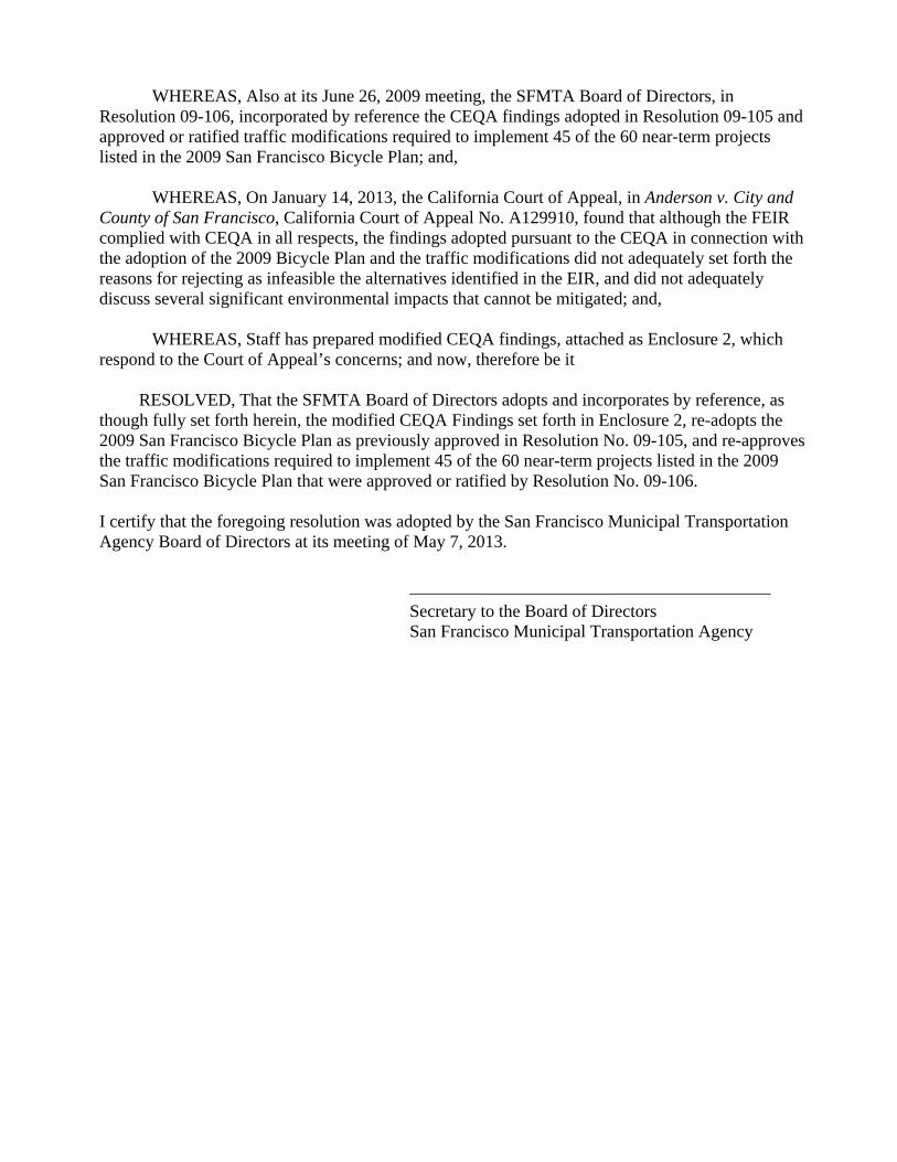
WHEREAS, Also at its June 26, 2009 meeting, the SFMTA Board of Directors, in Resolution 09-106, incorporated by reference the CEQA findings adopted in Resolution 09-105 and approved or ratified traffic modifications required to implement 45 of the 60 near-term projects listed in the 2009 San Francisco Bicycle Plan; and,
WHEREAS, On January 14, 2013, the California Court of Appeal, in Anderson v. City and
County of San Francisco, California Court of Appeal No. A129910, found that although the FEIR complied with CEQA in all respects, the findings adopted pursuant to the CEQA in connection with the adoption of the 2009 Bicycle Plan and the traffic modifications did not adequately set forth the reasons for rejecting as infeasible the alternatives identified in the EIR, and did not adequately discuss several significant environmental impacts that cannot be mitigated; and,
WHEREAS, Staff has prepared modified CEQA findings, attached as Enclosure 2, which
respond to the Court of Appeal’s concerns; and now, therefore be it
RESOLVED, That the SFMTA Board of Directors adopts and incorporates by reference, as though fully set forth herein, the modified CEQA Findings set forth in Enclosure 2, re-adopts the 2009 San Francisco Bicycle Plan as previously approved in Resolution No. 09-105, and re-approves the traffic modifications required to implement 45 of the 60 near-term projects listed in the 2009 San Francisco Bicycle Plan that were approved or ratified by Resolution No. 09-106.
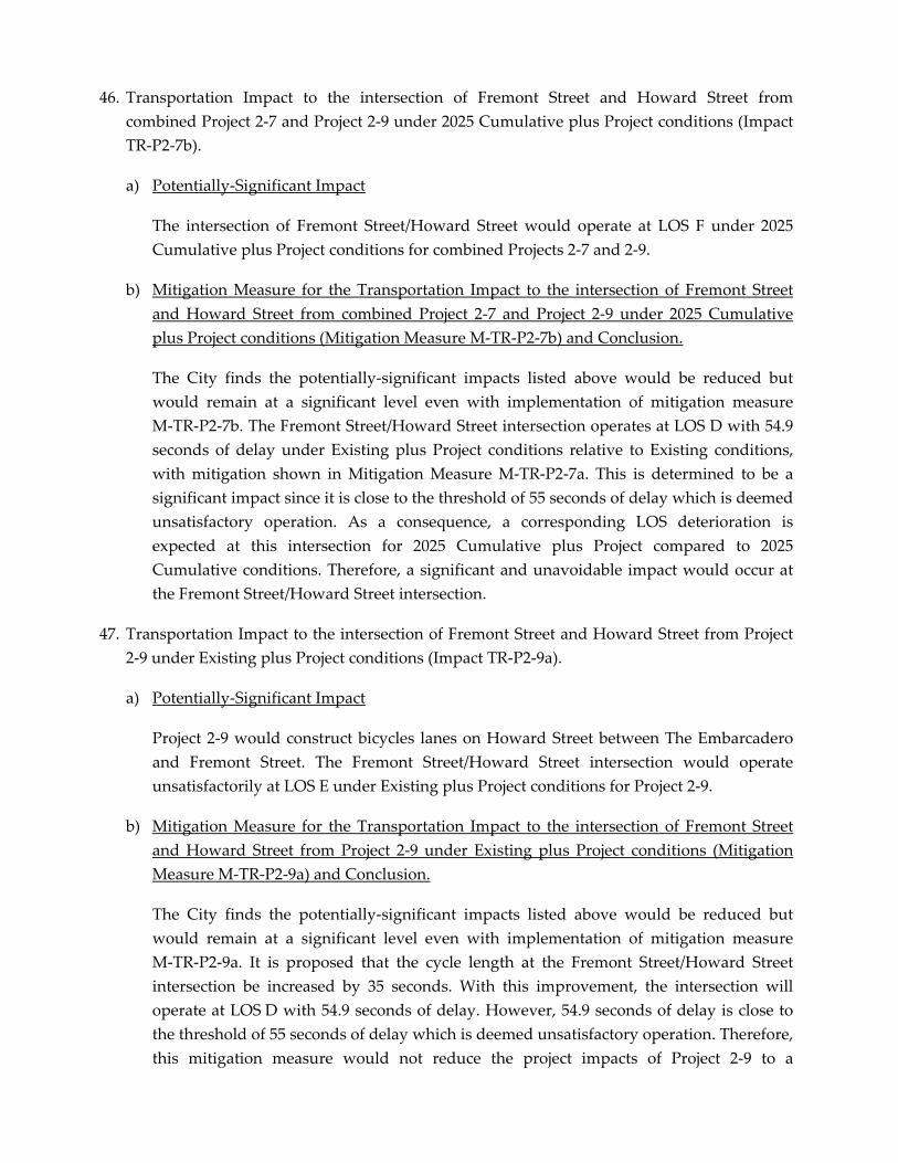
I certify that the foregoing resolution was adopted by the San Francisco Municipal Transportation Agency Board of Directors at its meeting of May 7, 2013.
_________________________________________
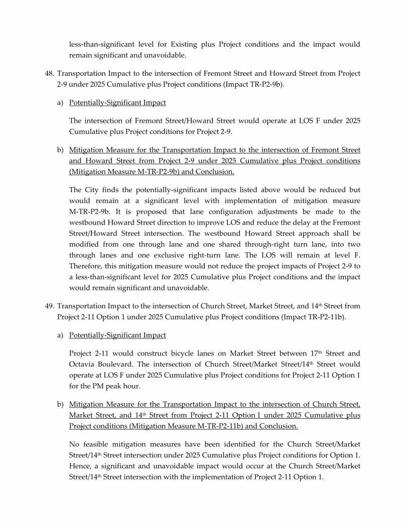
Secretary to the Board of Directors San Francisco Municipal Transportation Agency
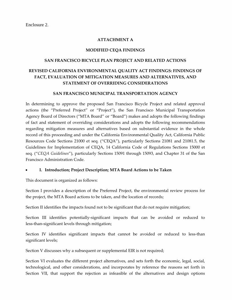
Enclosure 2.
ATTACHMENT A
MODIFIED CEQA FINDINGS
SAN FRANCISCO BICYCLE PLAN PROJECT AND RELATED ACTIONS
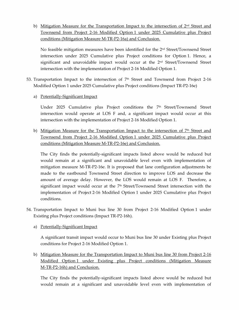
REVISED CALIFORNIA ENVIRONMENTAL QUALITY ACT FINDINGS: FINDINGS OF
FACT, EVALUATION OF MITIGATION MEASURES AND ALTERNATIVES, AND
STATEMENT OF OVERRIDING CONSIDERATIONS
SAN FRANCISCO MUNICIPAL TRANSPORTATION AGENCY
In determining to approve the proposed San Francisco Bicycle Project and related approval
actions (the “Preferred Project” or “Project”), the San Francisco Municipal Transportation
Agency Board of Directors (“MTA Board” or “Board”) makes and adopts the following findings
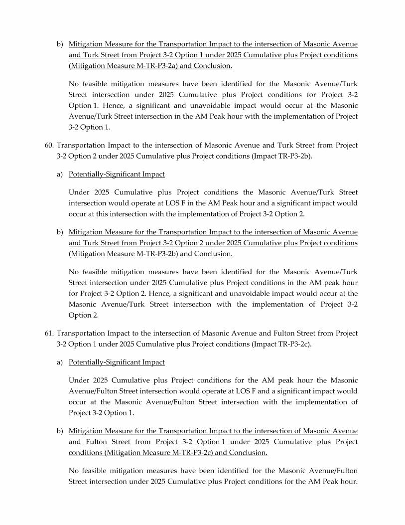
of fact and statement of overriding considerations and adopts the following recommendations
regarding mitigation measures and alternatives based on substantial evidence in the whole
record of this proceeding and under the California Environmental Quality Act, California Public
Resources Code Sections 21000 et seq. (“CEQA”), particularly Sections 21081 and 21081.5, the
Guidelines for Implementation of CEQA, 14 California Code of Regulations Sections 15000 et
seq. (“CEQA Guidelines”), particularly Sections 15091 through 15093, and Chapter 31 of the San
Francisco Administration Code.
I. Introduction; Project Description; MTA Board Actions to be Taken
This document is organized as follows:
Section I provides a description of the Preferred Project, the environmental review process for
the project, the MTA Board actions to be taken, and the location of records;
Section II identifies the impacts found not to be significant that do not require mitigation;
Section III identifies potentially‐significant impacts that can be avoided or reduced to
less‐than‐significant levels through mitigation;
Section IV identifies significant impacts that cannot be avoided or reduced to less‐than
significant levels;
Section V discusses why a subsequent or supplemental EIR is not required;
Section VI evaluates the different project alternatives, and sets forth the economic, legal, social,
technological, and other considerations, and incorporates by reference the reasons set forth in
Section VII, that support the rejection as infeasible of the alternatives and design options
analyzed, and presents the reasons for selecting preferred design options for the specified bicycle
projects; and
Section VII presents a statement of overriding considerations setting forth specific reasons in
support of the MTA Boardʹs actions despite the significant environmental impacts which remain.
This section also sets forth additional reasons for rejecting as infeasible the Alternatives not
incorporated into the Project, as described in Section VI.
Attached to these findings as Exhibit 1 is the Mitigation Monitoring and Reporting Program
(“MMRP”) for the mitigation measures that have been proposed for adoption for the Bicycle
Plan. The Mitigation Monitoring and Reporting Program is required by CEQA Section 21081.6
and CEQA Guidelines Section 15091. It provides a table setting forth each mitigation measure
listed in the Final EIR (“FEIR”) that is required to reduce or avoid a significant adverse impact.
Exhibit 1 also specifies the agency responsible for implementation of each measure and
establishes monitoring actions and a monitoring schedule.
These findings are based upon substantial evidence in the entire record before the MTA Board.
The references set forth in these findings to certain pages or sections of the EIR or responses to
comments in the Final EIR are for ease of reference and are not intended to provide an
exhaustive list of the evidence relied upon for these findings.
a. Project Description
The San Francisco Bicycle Plan Project would provide for the approval of the 2009 Bicycle Plan
and implementation of near‐term bicycle route improvement projects (near‐term improvements)
and minor improvements such as signage and pavement marking changes. It also identifies
long‐term bicycle route network improvement projects (long‐term improvements). The Bicycle
Plan includes policy goals, objectives, and actions to support the implementation of these and
related changes, at this time and in the future. By enacting these changes, the Preferred Project’s
overall goal is to increase safe bicycle use; the Bicycle Plan’s specific goals are to (1) refine and
expand the existing bicycle route network; (2) ensure plentiful, high‐quality bicycle parking to
complement the bicycle route network; (3) expand bicycle access to transit and bridges;
(4) educate the public about bicycle safety; (5) improve bicycle safety through targeted
enforcement; (6) promote and encourage safe bicycling; (7) adopt bicycle‐friendly practices and
policies; and (8) prioritize and increase bicycle funding. The primary Project sponsor is the
Municipal Transportation Agency.
Policy Actions
In order to accomplish its goals, the 2009 Bicycle Plan would implement policy actions,
near‐term improvements, and minor improvements, and consider long‐term improvements. The
Bicycle Plan also proposes amendments to the San Francisco General Plan and Planning Code.
Each proposed policy; near‐term improvement, long‐term improvement, and minor
improvement is described in Chapter IV, Project Description, and analyzed in Chapter V,
Subsections V.A.2 through V.A.5, pp. V.A.2‐1 through V.A.5‐30, of the DEIR. Applicable changes
to the General Plan and Planning Code are proposed to reflect the updated Bicycle Plan policies.
Minor Improvements
Minor improvements are treatments that may be implemented as necessary to improve
conditions for bicycle use within the City on the bicycle network. They include the following
design elements to improve bicycle travel: minor pavement marking and signage changes such
as the installation of colored pavement materials or sharrows (shared lane markings) or minor
changes to parking and traffic lane configurations; minor changes to intersection traffic signal
timing plans; the installation of bicycle boxes at certain intersections; and bicycle parking within
the public right‐of‐way, including bicycle racks on sidewalks meeting certain criteria and
on‐street bicycle parking. Environmental analysis for the minor improvements is presented in
Subsection V.A.4, (p V.A.4‐1), of the DEIR.
Long‐Term Improvements
Long‐term improvements are bicycle route network improvement projects that consist of either
major improvements to segments of the existing bicycle route network or are potential future
additions of new streets and pathways to the bicycle route network. These proposed long‐term
improvements include a wide range of potential design features that will improve the overall
connectivity and safety of the bicycle route network. Currently, neither a schedule nor specific
designs for these projects have been developed.
The anticipated long‐term improvements may include, but are not limited to, the following
design elements to improve bicycle travel along identified streets: signage changes; pavement
marking such as the installation of colored pavement materials and the installation of sharrows;
modifications to bus zones and parking configurations such as changes to the location,
configuration, and number of metered or unmetered parking spaces and loading zones; changes
to the locations and configurations of curbs, sidewalks and medians (including both planted and
unplanted), including widening of roadways; reconfiguration of intersections to improve bicycle
crossings, including installation of bicycle traffic signals; the installation of traffic calming
devices, including designation of bicycle boulevards that prioritize bicycle travel over other
transportation modes; installation of bicycle lanes, pathways or other bicycle facilities, including
in conjunction with the narrowing or removal of traffic lanes; the removal of parking spaces, and
the designation of shared bicycle and transit lanes.
The impacts of these future improvements are evaluated at a program level in this analysis with
regard to the Preferred Project footprint (the affected street right‐of‐way and park land). Once
fully developed, these future improvements, individually or collectively, may require further
project‐level environmental analysis that would consider the potential environmental effects of
these improvements. The program‐level analysis for these long‐term improvements is presented
in Chapter V, Subsection V.A.5, p. V.A.5‐1, of the DEIR.
b. Environmental Review
The Planning Department determined that an Environmental Impact Report (“EIR”) was
required for the Project and issued a Notice of Preparation and Notice of Public Scoping Meeting
on June 5, 2007. The Planning Department held a public scoping meeting on June 26, 2007 and
published the initial study for the Bicycle Plan Project on March 15, 2008. The Planning
Department published the Draft EIR and provided public notice of the availability of the Draft
EIR for public review and comment on November 26, 2008.
On November 26, 2008, a Notice of Completion and copies of the Draft EIR were distributed to
the State Clearinghouse. Notices of availability for the Draft EIR of the date and time of the
public hearings were posted on the Planning Departmentʹs website on November 26, 2008.
The Planning Commission held a duly noticed public hearing on the Draft EIR on January 8,
2009. At this hearing, opportunity for public comment was given, and public comment was
received on the Draft EIR. The Planning Department accepted public comments on the Draft EIR
from November 26, 2008 to January 13, 2009. The Departmentʹs Comments and Responses
document also responded to comments submitted as late as January 19, 2009.
The Planning Department published the Comments and Responses on the Draft EIR on June 11,
2009. This document includes responses to environmental comments on the Draft EIR made at
the public hearing on January 8, 2009 as well as written comments submitted on the Draft EIR
from November 26, 2008 to January 13, 2009 and comments submitted after the official close of
public comment. The comments and responses document also contains text changes to the Draft
EIR made by EIR preparers to correct or clarify information presented in the Draft EIR, including
changes to the Draft EIR text made in response to comments.
c. MTA Board Actions
The MTA Board is being requested to take the following actions to approve and implement the
Preferred Project.
Adopt CEQA findings and a Mitigation Monitoring and Reporting Program.
Adopt the 2009 Bicycle Transportation Plan, including 60 near‐term bicycle projects,
minor improvements along the bicycle network, and 24 long‐term projects, and
recommend to the Board of Supervisors adoption of the Bicycle Plan.
Legislate 45 of the near‐term bicycle projects for purposes of implementation.
Authorize various actions related to adoption of the Bicycle Plan, including expenditure
of funds on one or more bicycle projects.
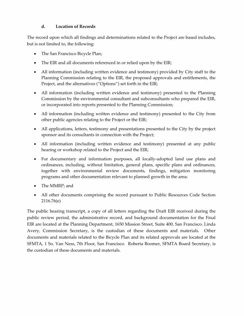
d. Location of Records
The record upon which all findings and determinations related to the Project are based includes,
but is not limited to, the following:
The San Francisco Bicycle Plan;
The EIR and all documents referenced in or relied upon by the EIR;
All information (including written evidence and testimony) provided by City staff to the
Planning Commission relating to the EIR, the proposed approvals and entitlements, the
Project, and the alternatives (“Options”) set forth in the EIR;
All information (including written evidence and testimony) presented to the Planning
Commission by the environmental consultant and subconsultants who prepared the EIR,
or incorporated into reports presented to the Planning Commission;
All information (including written evidence and testimony) presented to the City from
other public agencies relating to the Project or the EIR;
All applications, letters, testimony and presentations presented to the City by the project
sponsor and its consultants in connection with the Project;
All information (including written evidence and testimony) presented at any public
hearing or workshop related to the Project and the EIR;
For documentary and information purposes, all locally‐adopted land use plans and
ordinances, including, without limitation, general plans, specific plans and ordinances,
together with environmental review documents, findings, mitigation monitoring
programs and other documentation relevant to planned growth in the area;
The MMRP; and
All other documents comprising the record pursuant to Public Resources Code Section
2116.76(e)
The public hearing transcript, a copy of all letters regarding the Draft EIR received during the
public review period, the administrative record, and background documentation for the Final
EIR are located at the Planning Department, 1650 Mission Street, Suite 400, San Francisco. Linda
Avery, Commission Secretary, is the custodian of these documents and materials. Other
documents and materials related to the Bicycle Plan and its related approvals are located at the
SFMTA, 1 So. Van Ness, 7th Floor, San Francisco. Roberta Boomer, SFMTA Board Secretary, is
the custodian of these documents and materials.
II. Impacts Found Not To Be Significant, Thus Requiring No Mitigation
Finding: Based on substantial evidence in the whole record of this proceeding, the Board finds
that the implementation of the Preferred Project would not result any significant environmental
impacts in the following areas: Land Use; Parking; Aesthetics; Population and Housing; Wind
and Shadow; Recreation; Utilities and Service Systems; Public Services; Geology and Soils,
Avenue to Sloat Boulevard/St. Francis Boulevard, Modified Option 2; and Project 6‐2: Clipper
Street Bicycle Lanes, Douglass Street to Portola Drive, Option 1
As a result of changes to project designs, Project 6‐5 by itself is not associated with any
significant or unavoidable impact. However, the combined design modifications of Project 6‐5,
Project 6‐6, and Project 6‐2 produces a significant and unavoidable transit delay impact in the
cumulative condition, as further detailed in the section on significant and unavoidable impacts.
(See Impact # 101‐102.) Nevertheless, Project 6‐5 provides many benefits as Portola Drive is an
essential component to the City’s Bicycle Route Network. Portola Drive already serves as Bicycle
Routes 50, 55, and 60 which connect to Sloat Blvd., Clipper Street, 17th Street, Market Street, and
Haight Street. Portola Drive also offers the primary flat route through this topographically
challenging area of the City. By creating space specifically for bicyclists this project will greatly
enhance the environment for bicyclists, while reducing the conflicts associated with large
numbers of bicyclists riding on the sidewalk in this corridor. Motorists will also benefit from 8
additional parking spaces and a wider parking lane. By reducing lane width, dedicating more
space for bicyclists, slowing vehicle speed, and improving bicyclist visibility, bicycle lanes on
Portola Drive will ensure that a growing number of bicyclists can travel safely in this area. As a
result, this projectʹs benefits will outweigh the environmental detriments cited above.
The benefits of Project 6‐6 also outweigh the impacts generated by its implementation. Project
6‐6 serves as a necessary complement to Project 6‐5. This project would promote and encourage
safe bicycling along this segment of Portola Drive and complete a gap in the existing bicycle
route network along this important route, providing a connection between the Diamond
Heights, Saint Francis Wood, and West Portal neighborhoods.
Finally, Project 6‐2 it will close a gap on Route 60 of the Bicycle Route Network and offer
enhanced connectivity to numerous other routes (749/49/55/50) in the area. Clipper Street offers
the only east‐west connection between Noe Valley and Portola Drive and is essential component
to ensuring that bicyclists can travel through the challenging topography of this neighborhood.
Ridership in this area has also shown an increase in recent years (26 percent increase at Portola
and O’Shaughnessy since 2006) and this new infrastructure is essential to safely accommodating
new bicyclists. Thus, this projectʹs benefits outweigh the identified environmental impacts.
Bicycle Plan and Long‐Term Project Related Significant and Unavoidable Impacts and
Overriding Considerations
The following section addresses the Bicycle Plan‐related and Long term project‐related
significant and unavoidable impacts. Below is a list referring to the traffic, transit, and loading
impacts related to these approval actions. Such impacts are further detailed in the section on
significant and unavoidable impacts.
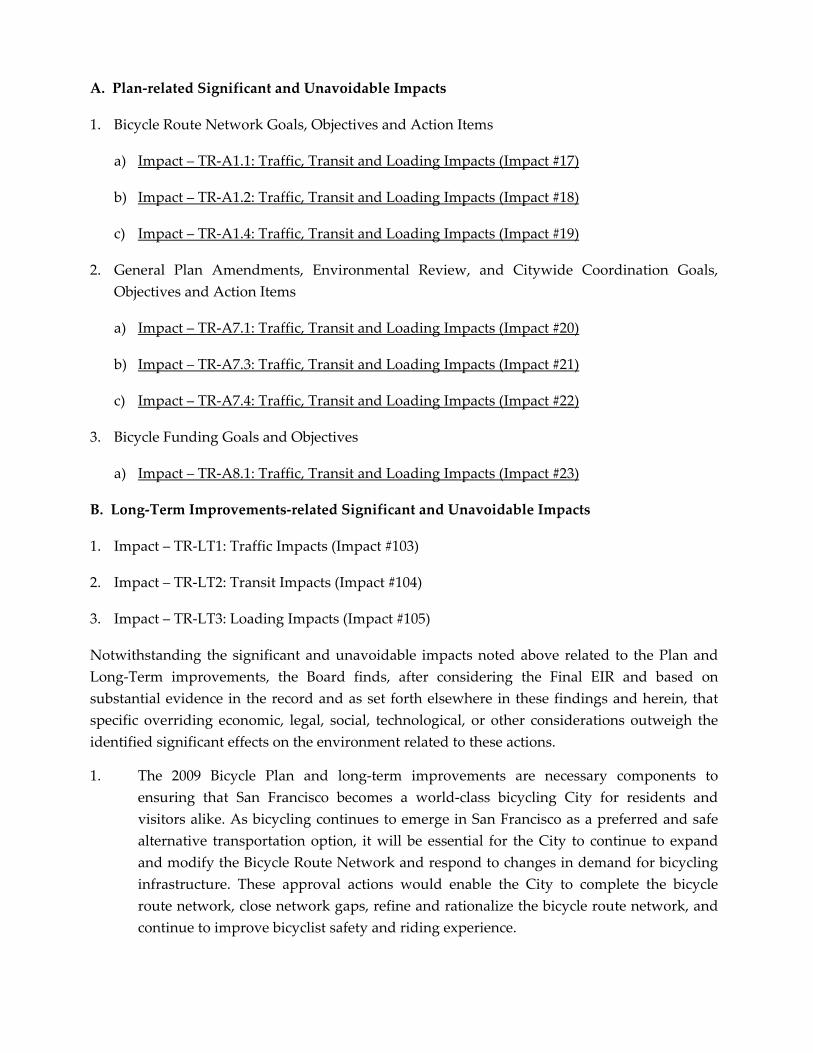
A. Plan‐related Significant and Unavoidable Impacts
1. Bicycle Route Network Goals, Objectives and Action Items
a) Impact – TR‐A1.1: Traffic, Transit and Loading Impacts (Impact #17)
b) Impact – TR‐A1.2: Traffic, Transit and Loading Impacts (Impact #18)
c) Impact – TR‐A1.4: Traffic, Transit and Loading Impacts (Impact #19)
2. General Plan Amendments, Environmental Review, and Citywide Coordination Goals,
Objectives and Action Items
a) Impact – TR‐A7.1: Traffic, Transit and Loading Impacts (Impact #20)
b) Impact – TR‐A7.3: Traffic, Transit and Loading Impacts (Impact #21)
c) Impact – TR‐A7.4: Traffic, Transit and Loading Impacts (Impact #22)
3. Bicycle Funding Goals and Objectives
a) Impact – TR‐A8.1: Traffic, Transit and Loading Impacts (Impact #23)
B. Long‐Term Improvements‐related Significant and Unavoidable Impacts
1. Impact – TR‐LT1: Traffic Impacts (Impact #103)
2. Impact – TR‐LT2: Transit Impacts (Impact #104)
3. Impact – TR‐LT3: Loading Impacts (Impact #105)
Notwithstanding the significant and unavoidable impacts noted above related to the Plan and
Long‐Term improvements, the Board finds, after considering the Final EIR and based on
substantial evidence in the record and as set forth elsewhere in these findings and herein, that
specific overriding economic, legal, social, technological, or other considerations outweigh the
identified significant effects on the environment related to these actions.
1. The 2009 Bicycle Plan and long‐term improvements are necessary components to
ensuring that San Francisco becomes a world‐class bicycling City for residents and
visitors alike. As bicycling continues to emerge in San Francisco as a preferred and safe
alternative transportation option, it will be essential for the City to continue to expand
and modify the Bicycle Route Network and respond to changes in demand for bicycling
infrastructure. These approval actions would enable the City to complete the bicycle
route network, close network gaps, refine and rationalize the bicycle route network, and
continue to improve bicyclist safety and riding experience.
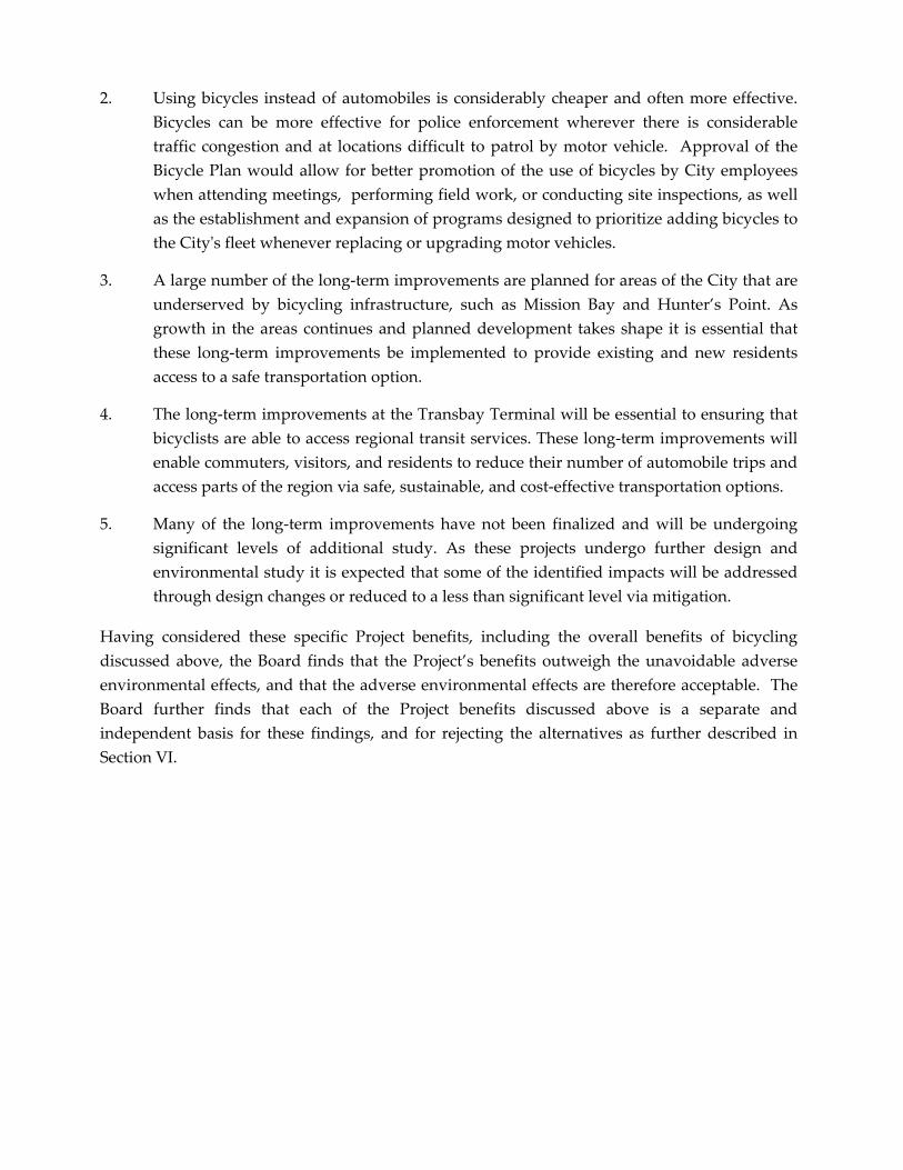
2. Using bicycles instead of automobiles is considerably cheaper and often more effective.
Bicycles can be more effective for police enforcement wherever there is considerable
traffic congestion and at locations difficult to patrol by motor vehicle. Approval of the
Bicycle Plan would allow for better promotion of the use of bicycles by City employees
when attending meetings, performing field work, or conducting site inspections, as well
as the establishment and expansion of programs designed to prioritize adding bicycles to
the Cityʹs fleet whenever replacing or upgrading motor vehicles.
3. A large number of the long‐term improvements are planned for areas of the City that are
underserved by bicycling infrastructure, such as Mission Bay and Hunter’s Point. As
growth in the areas continues and planned development takes shape it is essential that
these long‐term improvements be implemented to provide existing and new residents
access to a safe transportation option.
4. The long‐term improvements at the Transbay Terminal will be essential to ensuring that
bicyclists are able to access regional transit services. These long‐term improvements will
enable commuters, visitors, and residents to reduce their number of automobile trips and
access parts of the region via safe, sustainable, and cost‐effective transportation options.
5. Many of the long‐term improvements have not been finalized and will be undergoing
significant levels of additional study. As these projects undergo further design and
environmental study it is expected that some of the identified impacts will be addressed
through design changes or reduced to a less than significant level via mitigation.
Having considered these specific Project benefits, including the overall benefits of bicycling
discussed above, the Board finds that the Project’s benefits outweigh the unavoidable adverse
environmental effects, and that the adverse environmental effects are therefore acceptable. The
Board further finds that each of the Project benefits discussed above is a separate and
independent basis for these findings, and for rejecting the alternatives as further described in
Section VI.
MITIGATION MONITORING AND REPORTING PROGRAM
SAN FRANCICSO BICYCLE PLAN PROJECT CASE NO. 2007 .0347E MIT IGATION MONITORING AND REPORTING PROGRAM June 2009 Exhibit 1-1
Enclosure 3
Exhibit 1
Mitigation Monitoring and Reporting Program
Adopted Mitigation Measures Responsibility for Implementation
Mitigation Schedule
Mitigation Action
Monitoring/ Reporting
Responsibility Monitoring
Schedule
A-1 MITIGATION MEASURES AGREED TO BY THE PROJECT SPONSOR WHICH REDUCE THE IMPACT TO LESS-THAN-SIGNIFICANT
MITIGATION MEASURES FROM THE INITIAL STUDY
CULTURAL AND PALEONTOLOGICAL RESOURCES
Mitigation Measure 1: Archaeological Deposits Mitigation Measure (Accidental Discovery) The following mitigation measure is required to avoid any potential adverse effect from the proposed project on accidentally discovered buried or submerged historical resources as defined in CEQA Guidelines Section 15064.5(a)(c). The project sponsor shall distribute the Planning Department archeological resource “ALERT” sheet to the project prime contractor; to any project subcontractor (including demolition, excavation, grading, foundation, pile driving, etc. firms); or utilities firm involved in soils disturbing activities within the project site. Prior to any soils disturbing activities being undertaken each contractor is responsible for ensuring that the “ALERT” sheet is circulated to all field personnel including, machine operators, field crew, pile drivers, supervisory personnel, etc.
Project sponsor
Prior to any soil disturbing activities
Distribute Planning Department Archeological Resource “ALERT” sheet to Prime Contractor, sub-contractors and utilities firms.
Project sponsor, archaeologist and Environmental Review Officer (ERO)
Prior to any soil disturbing activities.
The project sponsor shall provide the Environmental Review Officer (ERO) with a signed affidavit from the responsible parties (prime contractor, subcontractor(s), and utilities firm) to the ERO confirming that all field personnel have received copies of the Alert Sheet.
Project sponsor
Submit signed affidavit of distribution to ERO.
Following distribution of “ALERT” sheet but prior to any soils disturbing activities.
SAN FRANCISCO BICYCLE PLAN PROJECT CASE NO. 2007 .0347E MIT IGATION MONITORING AND REPORTING PROGRAM June 2009
Exhibit 1-2
Adopted Mitigation Measures Responsibility for Implementation
Mitigation Schedule
Mitigation Action
Monitoring/ Reporting
Responsibility Monitoring
Schedule
Should any indication of an archeological resource be encountered during any soils disturbing activity of the project, the project Head Foreman and/or project sponsor shall immediately notify the ERO and shall immediately suspend any soils disturbing activities in the vicinity of the discovery until the ERO has determined what additional measures should be undertaken.
Head Foreman and/or project sponsor
Accidental discovery
Suspend any soils disturbing activity.
Notify ERO of accidental discovery.
If the ERO determines that an archeological resource may be present within the project site, the project sponsor shall retain the services of a qualified archeological consultant. The archeological consultant shall advise the ERO as to whether the discovery is an archeological resource, retains sufficient integrity, and is of potential scientific/historical/ cultural significance.
Project sponsor
In case of accidental discovery
If ERO determines an archeological resource may be present, services of a qualified archeological consultant to be retained.
If an archeological resource is present, the archeological consultant shall identify and evaluate the archeological resource. The archeological consultant shall make a recommendation as to what action, if any, is warranted. Based on this information, the ERO may require, if warranted, specific additional measures to be implemented by the project sponsor.
Archeological consultant
In case of accidental discovery
Identify and evaluate archeological resources.
Make recommendation to the ERO
Measures might include: preservation in situ of the archeological resource; an archaeological monitoring program; or an archeological testing program. If an archeological monitoring program or archeological testing program is required, it shall be consistent with the Major Environmental Analysis (MEA) division guidelines for such programs. The ERO may also require that the project sponsor immediately implement a site security program if the archeological resource is at risk from vandalism, looting, or other damaging actions.
Project sponsor After determination by the ERO of appropriate action to be implemented following evaluation of accidental discovery.
Implementation of Archeological measure required by ERO.
SAN FRANCISCO BICYCLE PLAN PROJECT CASE NO. 2007 .0347E MIT IGATION MONITORING AND REPORTING PROGRAM June 2009
Exhibit 1-3
Adopted Mitigation Measures Responsibility for Implementation
Mitigation Schedule
Mitigation Action
Monitoring/ Reporting
Responsibility Monitoring
Schedule
The project archeological consultant shall submit a Final Archeological Resources Report (FARR) to the ERO that evaluates the historical significance of any discovered archeological resource and describes the archeological and historical research methods employed in the archeological monitoring/data recovery program(s) undertaken. Information that may put at risk any archeological resource shall be provided in a separate removable insert within the final report.
Project sponsor Following completion of any* archeological field program.
(* required.)
Submittal of Draft/Final FARR to ERO.
Copies of the Draft FARR shall be sent to the ERO for review and approval. Once approved by the ERO, copies of the FARR shall be distributed as follows: California Archaeological Site Survey Northwest Information Center (NWIC) shall receive one (1) copy and the ERO shall receive a copy of the transmittal of the FARR to the NWIC. The MEA division of the Planning Department shall receive three copies of the FARR along with copies of any formal site recordation forms (CA DPR 523 series) and/or documentation for nomination to the National Register of Historic Places/California Register of Historical Resources. In instances of high public interest or interpretive value, the ERO may require a different final report content, format, and distribution than that presented above.
Project sponsor Distribution of Final FARR.
SAN FRANCISCO BICYCLE PLAN PROJECT CASE NO. 2007 .0347E MIT IGATION MONITORING AND REPORTING PROGRAM June 2009
Exhibit 1-4
Adopted Mitigation Measures Responsibility for Implementation
Mitigation Schedule
Mitigation Action
Monitoring/ Reporting
Responsibility Monitoring
Schedule
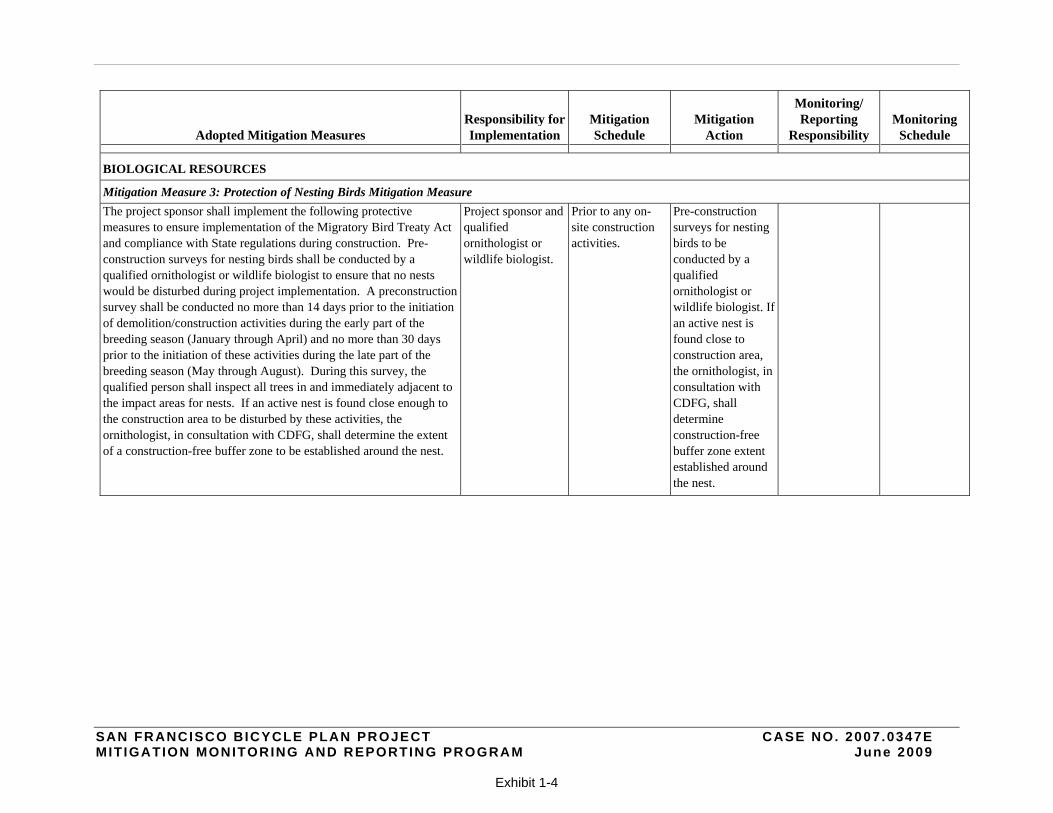
BIOLOGICAL RESOURCES
Mitigation Measure 3: Protection of Nesting Birds Mitigation Measure
The project sponsor shall implement the following protective measures to ensure implementation of the Migratory Bird Treaty Act and compliance with State regulations during construction. Pre-construction surveys for nesting birds shall be conducted by a qualified ornithologist or wildlife biologist to ensure that no nests would be disturbed during project implementation. A preconstruction survey shall be conducted no more than 14 days prior to the initiation of demolition/construction activities during the early part of the breeding season (January through April) and no more than 30 days prior to the initiation of these activities during the late part of the breeding season (May through August). During this survey, the qualified person shall inspect all trees in and immediately adjacent to the impact areas for nests. If an active nest is found close enough to the construction area to be disturbed by these activities, the ornithologist, in consultation with CDFG, shall determine the extent of a construction-free buffer zone to be established around the nest.
Project sponsor and qualified ornithologist or wildlife biologist.
Prior to any on-site construction activities.
Pre-construction surveys for nesting birds to be conducted by a qualified ornithologist or wildlife biologist. If an active nest is found close to construction area, the ornithologist, in consultation with CDFG, shall determine construction-free buffer zone extent established around the nest.
SAN FRANCISCO BICYCLE PLAN PROJECT CASE NO. 2007 .0347E MIT IGATION MONITORING AND REPORTING PROGRAM June 2009
Exhibit 1-5
Adopted Mitigation Measures Responsibility for Implementation
Mitigation Schedule
Mitigation Action
Monitoring/ Reporting
Responsibility Monitoring
Schedule
MITIGATION MEASURES FROM THE DRAFT EIR
TRANSPORTATION, CIRCULATION, AND PARKING
NEAR-TERM IMPROVEMENTS
Cluster 1: Financial District/North Beach Area
M-TR-P1-1a:
An alternative school passenger drop-off location would have to be identified to accommodate passenger loading demand, such as expanding the existing passenger drop-off location along the east side of Franklin Street between Pacific Avenue and Broadway on the west side of the school building. Alternatively, the passenger drop off zone on Broadway could be maintained by eliminating the proposed eastbound bicycle lane between Franklin Street and Van Ness Avenue and having bicyclists share the curb lane with motor vehicles, similar to existing conditions. With the implementation of either of these mitigation measures, the significant impact on loading for the students of Saint Brigid School would be reduced to less than significant under Existing plus Project conditions for Project 1-1.
SFMTA Prior to implementation of Project 1-1.
SFMTA to identify and implement an alternative passenger loading zone as described.
SFMTA to provide a report to ERO.
Quarterly report to ERO as new improvements are implemented.
M-TR-P1-1b:
Refer to Mitigation Measure M-TR-P1-1a, above for mitigation of this impact. With the implementation of either of these mitigation measures, the significant impact on loading for the students of Saint Brigid School would be reduced to less than significant under 2025 Cumulative plus Project conditions for Project 1-1.
SFMTA Prior to implementation of Project 1-1.
SFMTA to identify and implement an alternative passenger loading zone as described.
SFMTA to provide a report to ERO.
Quarterly report to ERO as new improvements are implemented.
SAN FRANCISCO BICYCLE PLAN PROJECT CASE NO. 2007 .0347E MIT IGATION MONITORING AND REPORTING PROGRAM June 2009
Exhibit 1-6
Adopted Mitigation Measures Responsibility for Implementation
Mitigation Schedule
Mitigation Action
Monitoring/ Reporting
Responsibility Monitoring
Schedule
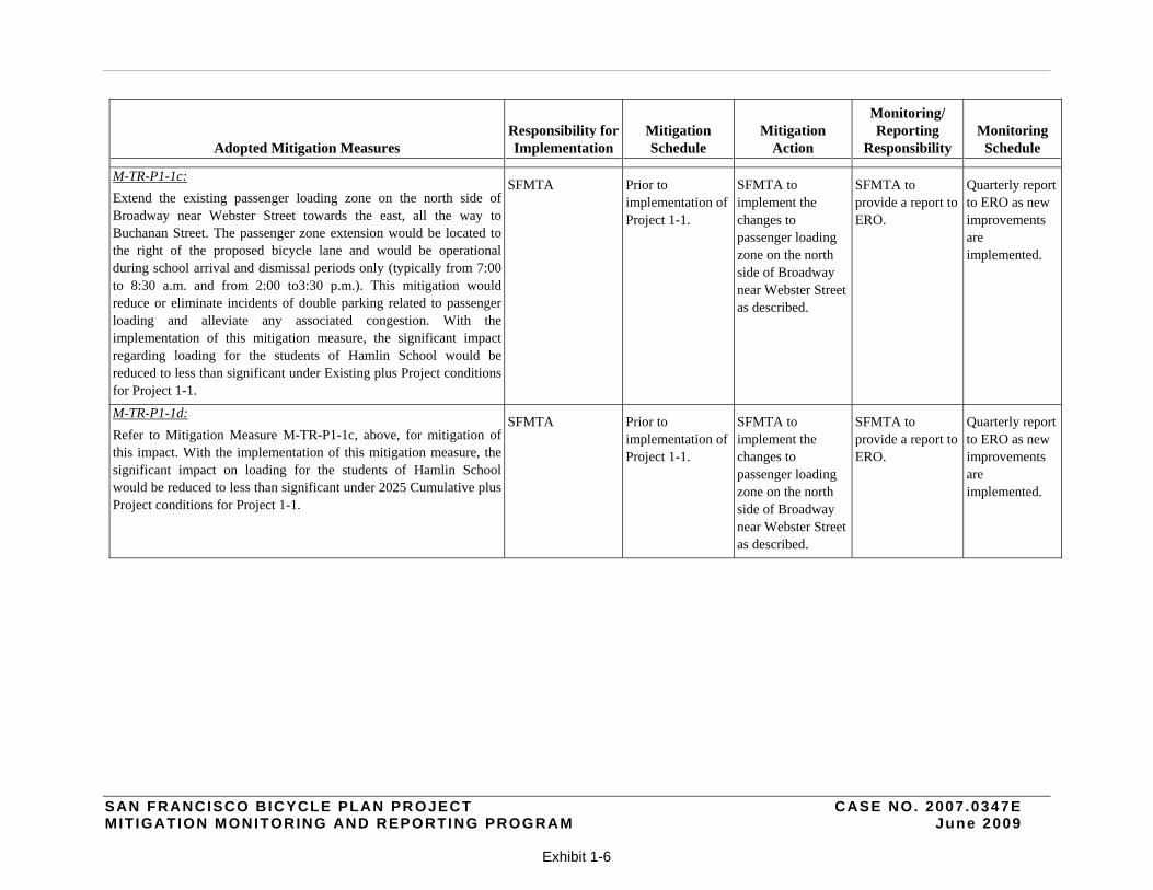
M-TR-P1-1c:
Extend the existing passenger loading zone on the north side of Broadway near Webster Street towards the east, all the way to Buchanan Street. The passenger zone extension would be located to the right of the proposed bicycle lane and would be operational during school arrival and dismissal periods only (typically from 7:00 to 8:30 a.m. and from 2:00 to3:30 p.m.). This mitigation would reduce or eliminate incidents of double parking related to passenger loading and alleviate any associated congestion. With the implementation of this mitigation measure, the significant impact regarding loading for the students of Hamlin School would be reduced to less than significant under Existing plus Project conditions for Project 1-1.
SFMTA Prior to implementation of Project 1-1.
SFMTA to implement the changes to passenger loading zone on the north side of Broadway near Webster Street as described.
SFMTA to provide a report to ERO.
Quarterly report to ERO as new improvements are implemented.
M-TR-P1-1d:
Refer to Mitigation Measure M-TR-P1-1c, above, for mitigation of this impact. With the implementation of this mitigation measure, the significant impact on loading for the students of Hamlin School would be reduced to less than significant under 2025 Cumulative plus Project conditions for Project 1-1.
SFMTA Prior to implementation of Project 1-1.
SFMTA to implement the changes to passenger loading zone on the north side of Broadway near Webster Street as described.
SFMTA to provide a report to ERO.
Quarterly report to ERO as new improvements are implemented.
SAN FRANCISCO BICYCLE PLAN PROJECT CASE NO. 2007 .0347E MIT IGATION MONITORING AND REPORTING PROGRAM June 2009
Exhibit 1-7
Adopted Mitigation Measures Responsibility for Implementation
Mitigation Schedule
Mitigation Action
Monitoring/ Reporting
Responsibility Monitoring
Schedule
M-TR-P1-3a:
Per the California Manual on Uniform Traffic Control Devices (MUTCD), a signal warrant analysis was conducted to determine the feasibility of signalization of the Van Ness/North Point Street intersection. The criteria for signal warrants were satisfied. Therefore, signalization of this intersection was proposed as the mitigation measure. The intersection shall be converted from a three-way stop-controlled (FWSC) intersection to a signalized intersection (with the application of 90 seconds of cycle length) to improve intersection operations. With this improvement, the intersection operation would improve to LOS B, with 19 seconds of delay and a V/C ratio of 0.65. The intersection operations would improve from LOS E to LOS B for 2025 Cumulative plus Project conditions. Minimum green times required for pedestrians to cross the intersection would be maintained to the signal. Hence, this mitigation measure would reduce impacts of Project 1-3 to a less-than-significant level.
SFMTA Prior to implementation of Project 1-3.
SFMTA to convert the intersection from a three-way stop-controlled intersection into a signalized intersection as described.
SFMTA to provide a report to ERO.
Quarterly report to ERO as new improvements are implemented.
Cluster 2: South of Market Area
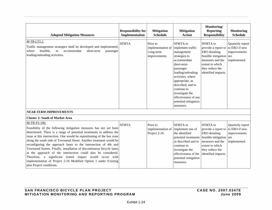
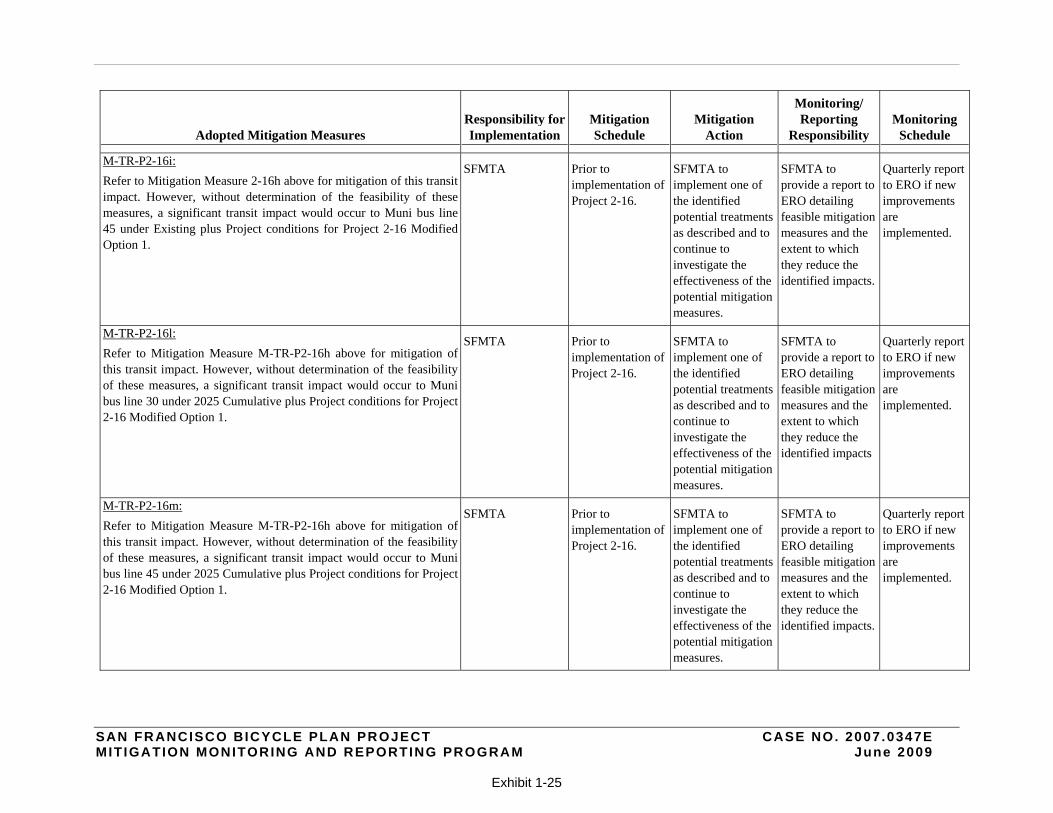
M-TR-P2-1o (Projects 2-1 and 2-16 combined):
The implementation of Option 1 of the combined Projects 2-1 and 2-16 under Existing plus Project conditions would add approximately 863 seconds (14.4 minutes) of delay for Muni bus line 10. With mitigation as described for the 2nd Street/ Harrison Street, and 2nd
Street/ Folsom Street intersections, approximately 27 seconds of delay southbound and 266 seconds (4.4 minutes) of delay northbound would be added to Muni bus line 10. The total added delay of 293 seconds (4.8 minutes) would be less than the transit delay threshold of six minutes. Therefore, impacts to Muni bus line 10 from Modified Option 1 of the combined Projects 2-1 and 2-16 under Existing plus Project conditions would be reduced to a less-than-significant level.
SFMTA Prior to implementation of Project 2-1 and 2-16 combined.
SFMTA to modify the southbound 2nd Street traffic signal phase as described.
SFMTA to provide a report to ERO.
Quarterly report to ERO as new improvements are implemented.
SAN FRANCISCO BICYCLE PLAN PROJECT CASE NO. 2007 .0347E MIT IGATION MONITORING AND REPORTING PROGRAM June 2009
Exhibit 1-8
Adopted Mitigation Measures Responsibility for Implementation
Mitigation Schedule
Mitigation Action
Monitoring/ Reporting
Responsibility Monitoring
Schedule
M-TR-P2-1s:
The implementation of Project 2-1 Modified Option 1 under Existing plus Project conditions would add approximately 845 seconds (14.1 minutes) of delay for Muni bus line 10. With mitigation as described for the 2nd Street/ Harrison Street, and 2nd Street/Folsom Street intersections, approximately 27 seconds of delay southbound and 249 seconds (4.2 minutes) of delay northbound would be added to Muni bus line 10. The total added delay of 276 seconds (4.6 minutes) would be less than the transit delay threshold of six minutes. Therefore, impacts to Muni bus line 10 for individual Project 2-1 Modified Option 1 under Existing plus Project conditions would be reduced to a less-than-significant level.
SFMTA Prior to implementation of Project 2-1.
SFMTA to modify the southbound 2nd Street traffic signal phase as described.
SFMTA to provide a report to ERO.
Quarterly report to ERO as new improvements are implemented.
M-TR-P2-1u:
The implementation of individual Project 2-1 Option 1 under 2025 Cumulative plus Project conditions would add approximately 450 seconds (7.5 minutes) of delay for Muni bus line 10. With mitigation as described for the 2nd Street/ Harrison Street, and 2nd Street/Folsom Street intersections, delay would be reduced by approximately 170 seconds (2.8 minutes) southbound with approximately 403 seconds (6.7 minutes) of delay added northbound to Muni bus line 10. The total added delay of 233 seconds (3.8 minutes) would be less than the transit delay threshold of six minutes. Therefore, impacts to Muni bus line 10 for individual Project 2-1 Modified Option 1 under 2025 Cumulative plus Project conditions would be reduced to a less-than-significant level.
SFMTA Prior to implementation of Project 2-1.
SFMTA to modify the southbound 2nd Street traffic signal phase as described.
SFMTA to provide a report to ERO.
Quarterly report to ERO as new improvements are implemented.
SAN FRANCISCO BICYCLE PLAN PROJECT CASE NO. 2007 .0347E MIT IGATION MONITORING AND REPORTING PROGRAM June 2009
Exhibit 1-9
Adopted Mitigation Measures Responsibility for Implementation
Mitigation Schedule
Mitigation Action
Monitoring/ Reporting
Responsibility Monitoring
Schedule
M-TR-P2-16c:
Six seconds of green time shall be added to the eastbound Townsend Street approach and six seconds of green time shall be reduced from the northbound 7th Street approach, to improve the 7th
Street/Townsend Street intersection operations from LOS F to LOS D, with 35.2 seconds of delay. It has been ensured that the minimum green times required for pedestrians to cross the intersection have been maintained even after the green time adjustments to the signal. Hence, this mitigation measure would reduce the project impacts of Project 2-16 Modified Option 1 to a less-than-significant level.
SFMTA Prior to implementation of Project 2-16.
SFMTA to modify the traffic signal timing for the northbound 7th Street approach as described.
SFMTA to provide a report to ERO.
Quarterly report to ERO as new improvements are implemented.
M-TR-P2-16g:
The westbound Townsend Street approach shall be modified from a permitted phase to a protected signal phase. In addition, five seconds of green time shall be added to the westbound Townsend Street approach and five seconds of green time shall be reduced from the southbound 4th Street approach. This would improve the 4th
Street/Townsend Street intersection operations from LOS F to LOS D, with 42.2 seconds of delay. It has been ensured that the minimum green times required for pedestrians to cross the intersection have been maintained even after the green time adjustments to the signal. Hence, this mitigation measure would reduce the project impacts of Project 2-16 Modified Option 1 to a less-than-significant level.
SFMTA Prior to implementation of Project 2-16.
SFMTA to modify the signal phase timing to the westbound Townsend Street direction as described.
SFMTA to provide a report to ERO.
Quarterly report to ERO as new improvements are implemented.
SAN FRANCISCO BICYCLE PLAN PROJECT CASE NO. 2007 .0347E MIT IGATION MONITORING AND REPORTING PROGRAM June 2009
Exhibit 1-10
Adopted Mitigation Measures Responsibility for Implementation
Mitigation Schedule
Mitigation Action
Monitoring/ Reporting
Responsibility Monitoring
Schedule
Cluster 3: Civic Center/Western Addition
M-TR-P3-1a (Projects 3-1 and 3-2 combined):
Four seconds of green time shall be added to the northbound and southbound directions of Masonic Avenue and four seconds of green time shall be reduced from the westbound direction of Fell Street. With these adjustments, Masonic Avenue/Fell Street intersection operations will improve to LOS D, with 52.7 seconds of delay. It has been ensured that the minimum green times required for pedestrians to cross the intersection would be maintained even after the green time adjustments to the signal. Hence, this mitigation measure would reduce impacts from combined Projects 3-1 and 3-2 Option 1 to a less-than-significant level under Existing plus Project conditions.
SFMTA Prior to implementation of Project 3-1 and 3-2 combined.
SFMTA to implement the signal phase timing changes as described.
SFMTA to provide a report to ERO.
Quarterly report to ERO as new improvements are implemented.
M-TR-P3-2f:
Four seconds of green time shall be added to the northbound and southbound Masonic Avenue directions, with a corresponding reduction in green time in the westbound Fell Street direction of four seconds. With these adjustments, the Masonic Avenue/Fell Street intersection operations would improve to LOS D, with 45.8 seconds of delay and a V/C ratio of 1.1. It has been ensured that the minimum green times required for pedestrians to cross the intersection have been maintained even after the green time adjustments to the signal. Hence, this mitigation measure would reduce the project impacts at the Masonic Avenue/Fell Street intersection to a less-than-significant level for Project 3-2 Option 2 under Existing plus Project conditions.
SFMTA Prior to implementation of Project 3-2.
SFMTA to implement the signal phase timing change as described.
SFMTA to provide a report to ERO.
Quarterly report to ERO as new improvements are implemented.
SAN FRANCISCO BICYCLE PLAN PROJECT CASE NO. 2007 .0347E MIT IGATION MONITORING AND REPORTING PROGRAM June 2009
Exhibit 1-11
Adopted Mitigation Measures Responsibility for Implementation
Mitigation Schedule
Mitigation Action
Monitoring/ Reporting
Responsibility Monitoring
Schedule
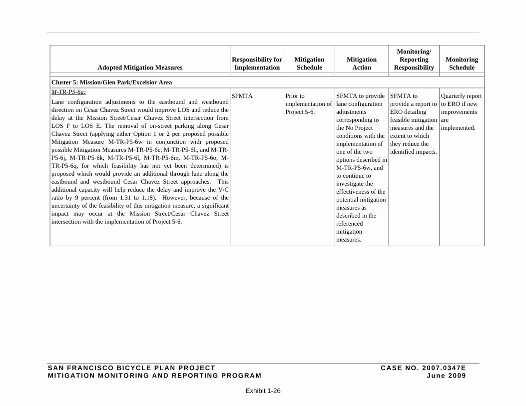
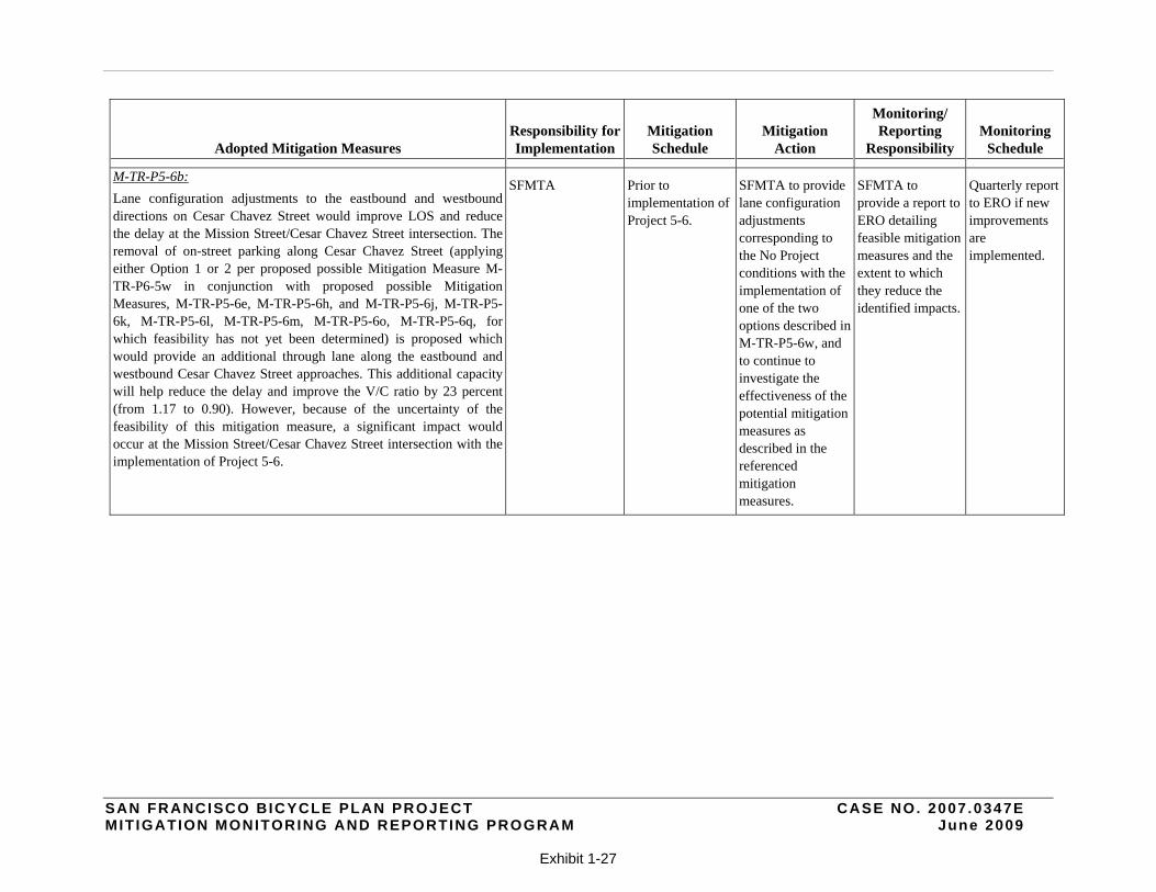
Cluster 5: Mission/Glen Park/Excelsior Area
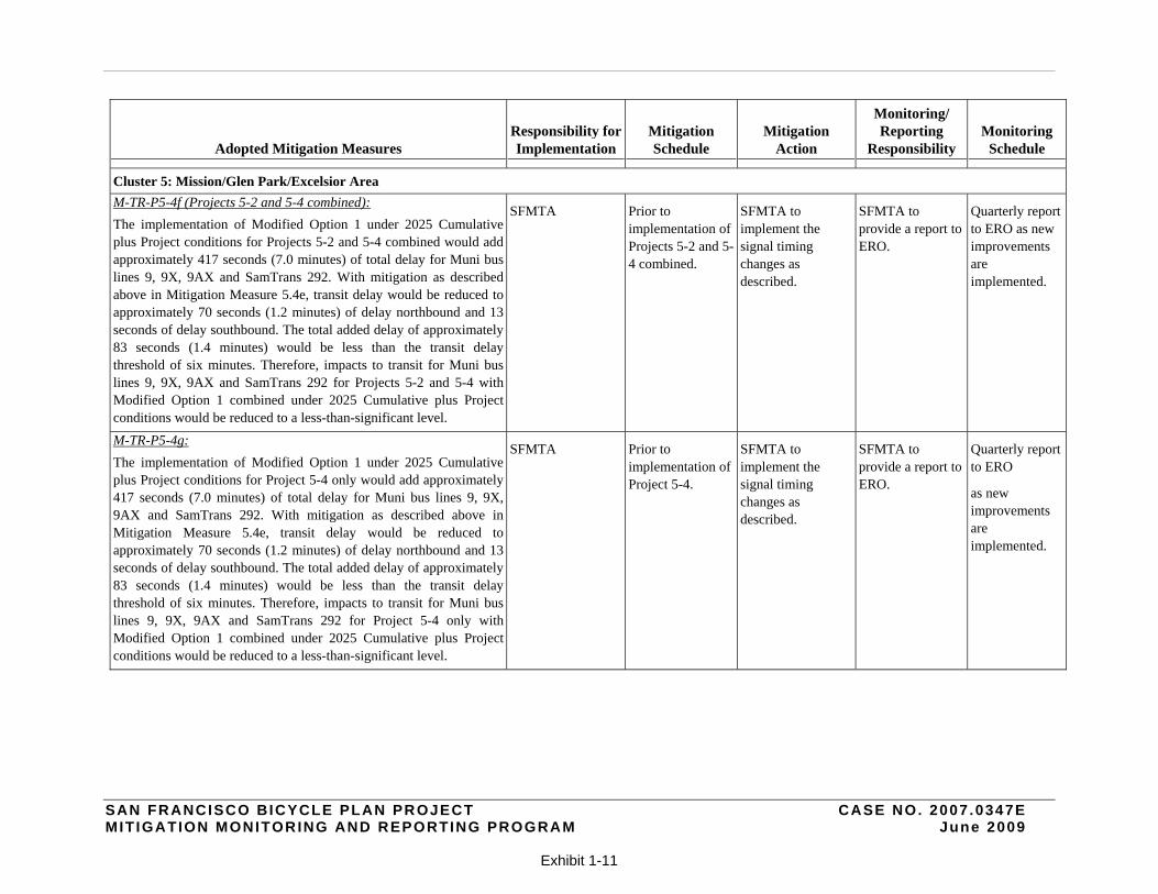
M-TR-P5-4f (Projects 5-2 and 5-4 combined):
The implementation of Modified Option 1 under 2025 Cumulative plus Project conditions for Projects 5-2 and 5-4 combined would add approximately 417 seconds (7.0 minutes) of total delay for Muni bus lines 9, 9X, 9AX and SamTrans 292. With mitigation as described above in Mitigation Measure 5.4e, transit delay would be reduced to approximately 70 seconds (1.2 minutes) of delay northbound and 13 seconds of delay southbound. The total added delay of approximately 83 seconds (1.4 minutes) would be less than the transit delay threshold of six minutes. Therefore, impacts to transit for Muni bus lines 9, 9X, 9AX and SamTrans 292 for Projects 5-2 and 5-4 with Modified Option 1 combined under 2025 Cumulative plus Project conditions would be reduced to a less-than-significant level.
SFMTA Prior to implementation of Projects 5-2 and 5-4 combined.
SFMTA to implement the signal timing changes as described.
SFMTA to provide a report to ERO.
Quarterly report to ERO as new improvements are implemented.
M-TR-P5-4g:
The implementation of Modified Option 1 under 2025 Cumulative plus Project conditions for Project 5-4 only would add approximately 417 seconds (7.0 minutes) of total delay for Muni bus lines 9, 9X, 9AX and SamTrans 292. With mitigation as described above in Mitigation Measure 5.4e, transit delay would be reduced to approximately 70 seconds (1.2 minutes) of delay northbound and 13 seconds of delay southbound. The total added delay of approximately 83 seconds (1.4 minutes) would be less than the transit delay threshold of six minutes. Therefore, impacts to transit for Muni bus lines 9, 9X, 9AX and SamTrans 292 for Project 5-4 only with Modified Option 1 combined under 2025 Cumulative plus Project conditions would be reduced to a less-than-significant level.
SFMTA Prior to implementation of Project 5-4.
SFMTA to implement the signal timing changes as described.
SFMTA to provide a report to ERO.
Quarterly report to ERO
as new improvements are implemented.
SAN FRANCISCO BICYCLE PLAN PROJECT CASE NO. 2007 .0347E MIT IGATION MONITORING AND REPORTING PROGRAM June 2009
Exhibit 1-12
Adopted Mitigation Measures Responsibility for Implementation
Mitigation Schedule
Mitigation Action
Monitoring/ Reporting
Responsibility Monitoring
Schedule
A-2 MITIGATION MEASURES AGREED TO BY THE PROJECT SPONSOR FOR WHICH IMPLEMENTATION WOULD IMPROVE CONDITIONS BUT WOULD NOT REDUCE THE EFFECTS TO LESS-THAN-SIGNIFICANT
NEAR-TERM IMPROVEMENTS
Cluster 2: South of Market Area
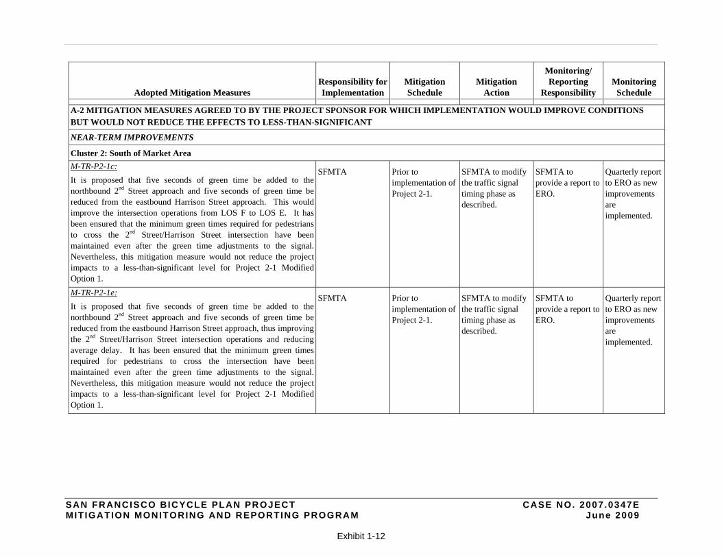
M-TR-P2-1c:
It is proposed that five seconds of green time be added to the northbound 2nd Street approach and five seconds of green time be reduced from the eastbound Harrison Street approach. This would improve the intersection operations from LOS F to LOS E. It has been ensured that the minimum green times required for pedestrians to cross the 2nd Street/Harrison Street intersection have been maintained even after the green time adjustments to the signal. Nevertheless, this mitigation measure would not reduce the project impacts to a less-than-significant level for Project 2-1 Modified Option 1.
SFMTA Prior to implementation of Project 2-1.
SFMTA to modify the traffic signal timing phase as described.
SFMTA to provide a report to ERO.
Quarterly report to ERO as new improvements are implemented.
M-TR-P2-1e:
It is proposed that five seconds of green time be added to the northbound 2nd Street approach and five seconds of green time be reduced from the eastbound Harrison Street approach, thus improving the 2nd Street/Harrison Street intersection operations and reducing average delay. It has been ensured that the minimum green times required for pedestrians to cross the intersection have been maintained even after the green time adjustments to the signal. Nevertheless, this mitigation measure would not reduce the project impacts to a less-than-significant level for Project 2-1 Modified Option 1.
SFMTA Prior to implementation of Project 2-1.
SFMTA to modify the traffic signal timing phase as described.
SFMTA to provide a report to ERO.
Quarterly report to ERO as new improvements are implemented.
SAN FRANCISCO BICYCLE PLAN PROJECT CASE NO. 2007 .0347E MIT IGATION MONITORING AND REPORTING PROGRAM June 2009
Exhibit 1-13
Adopted Mitigation Measures Responsibility for Implementation
Mitigation Schedule
Mitigation Action
Monitoring/ Reporting
Responsibility Monitoring
Schedule
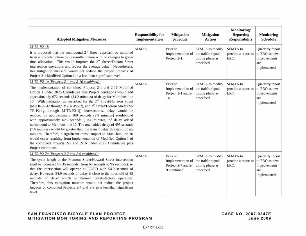
M-TR-P2-1i:
It is proposed that the southbound 2nd Street approach be modified from a protected phase to a permitted phase with no changes to green time allocation. This would improve the 2nd Street/Folsom Street intersection operations and reduce the average delay. Nevertheless, this mitigation measure would not reduce the project impacts of Project 2-1 Modified Option 1 to a less-than-significant level.
SFMTA Prior to implementation of Project 2-1.
SFMTA to modify the traffic signal timing phase as described.
SFMTA to provide a report to ERO.
Quarterly report to ERO as new improvements are implemented.
M-TR-P2-1q (Projects 2-1 and 2-16 combined):
The implementation of combined Projects 2-1 and 2-16 Modified Option 1 under 2025 Cumulative plus Project conditions would add approximately 672 seconds (11.2 minutes) of delay for Muni bus line 10. With mitigation as described for the 2nd Street/Harrison Street (M-TR-P2-1c through M-TR-P2-1f), and 2nd Street/Folsom Street (M-TR-P2-1g through M-TR-P2-1j) intersections, delay would be reduced by approximately 169 seconds (2.8 minutes) southbound with approximately 625 seconds (10.4 minutes) of delay added northbound to Muni bus line 10. The total added delay of 495 seconds (7.6 minutes) would be greater than the transit delay threshold of six minutes. Therefore, a significant transit impact to Muni bus line 10 would occur resulting from implementation of Modified Option 1 of the combined Projects 2-1 and 2-16 under 2025 Cumulative plus Project conditions.
SFMTA Prior to implementation of Project 2-1 and 2-16.
SFMTA to modify the traffic signal timing phase as described.
SFMTA to provide a report to ERO.
Quarterly report to ERO as new improvements are implemented.
M-TR-P2-7a (Projects 2-7 and 2-9 combined):
The cycle length at the Fremont Street/Howard Street intersection shall be increased by 35 seconds (from 60 seconds to 95 seconds), so that the intersection will operate at LOS D with 54.9 seconds of delay. However, 54.9 seconds of delay is close to the threshold of 55 seconds of delay which is deemed unsatisfactory operation. Therefore, this mitigation measure would not reduce the project impacts of combined Projects 2-7 and 2-9 to a less-than-significant level.
SFMTA Prior to implementation of Project 2-7 and 2-9 combined.
SFMTA to modify the traffic signal timing phase as described.
SFMTA to provide a report to ERO.
Quarterly report to ERO as new improvements are implemented.
SAN FRANCISCO BICYCLE PLAN PROJECT CASE NO. 2007 .0347E MIT IGATION MONITORING AND REPORTING PROGRAM June 2009
Exhibit 1-14
Adopted Mitigation Measures Responsibility for Implementation
Mitigation Schedule
Mitigation Action
Monitoring/ Reporting
Responsibility Monitoring
Schedule
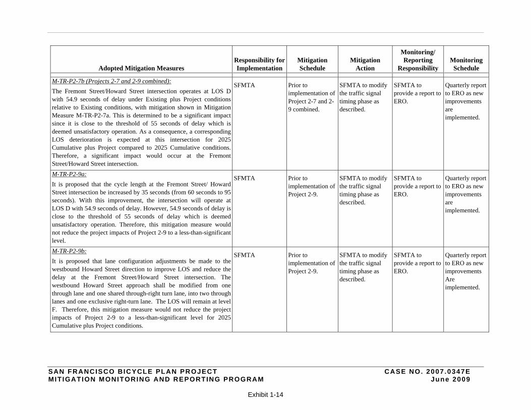
M-TR-P2-7b (Projects 2-7 and 2-9 combined):
The Fremont Street/Howard Street intersection operates at LOS D with 54.9 seconds of delay under Existing plus Project conditions relative to Existing conditions, with mitigation shown in Mitigation Measure M-TR-P2-7a. This is determined to be a significant impact since it is close to the threshold of 55 seconds of delay which is deemed unsatisfactory operation. As a consequence, a corresponding LOS deterioration is expected at this intersection for 2025 Cumulative plus Project compared to 2025 Cumulative conditions. Therefore, a significant impact would occur at the Fremont Street/Howard Street intersection.
SFMTA Prior to implementation of Project 2-7 and 2-9 combined.
SFMTA to modify the traffic signal timing phase as described.
SFMTA to provide a report to ERO.
Quarterly report to ERO as new improvements are implemented.
M-TR-P2-9a:
It is proposed that the cycle length at the Fremont Street/ Howard Street intersection be increased by 35 seconds (from 60 seconds to 95 seconds). With this improvement, the intersection will operate at LOS D with 54.9 seconds of delay. However, 54.9 seconds of delay is close to the threshold of 55 seconds of delay which is deemed unsatisfactory operation. Therefore, this mitigation measure would not reduce the project impacts of Project 2-9 to a less-than-significant level.
SFMTA Prior to implementation of Project 2-9.
SFMTA to modify the traffic signal timing phase as described.
SFMTA to provide a report to ERO.
Quarterly report to ERO as new improvements are implemented.
M-TR-P2-9b:
It is proposed that lane configuration adjustments be made to the westbound Howard Street direction to improve LOS and reduce the delay at the Fremont Street/Howard Street intersection. The westbound Howard Street approach shall be modified from one through lane and one shared through-right turn lane, into two through lanes and one exclusive right-turn lane. The LOS will remain at level F. Therefore, this mitigation measure would not reduce the project impacts of Project 2-9 to a less-than-significant level for 2025 Cumulative plus Project conditions.
SFMTA Prior to implementation of Project 2-9.
SFMTA to modify the traffic signal timing phase as described.
SFMTA to provide a report to ERO.
Quarterly report to ERO as new improvements Are implemented.
SAN FRANCISCO BICYCLE PLAN PROJECT CASE NO. 2007 .0347E MIT IGATION MONITORING AND REPORTING PROGRAM June 2009
Exhibit 1-15
Adopted Mitigation Measures Responsibility for Implementation
Mitigation Schedule
Mitigation Action
Monitoring/ Reporting
Responsibility Monitoring
Schedule
M-TR-P2-16e:
It is proposed that lane configuration adjustments be made to the eastbound Townsend Street direction to improve LOS and decrease the amount of average delay. Assuming that the existing railroad alignment would be removed, the eastbound Townsend Street approach would be modified from one shared through-left turn lane and one exclusive right-turn lane to one shared through-left turn lane and one shared through-right turn lane. Hence, this lane adjustment decreases the amount of average delay and reduces the V/C ratio by 78 percent (from 5.52 to 1.24). This would improve intersection operations. Nevertheless, a significant impact would occur at the 7th
Street/Townsend Street intersection with the implementation of Project 2-16 Option 1 under 2025 Cumulative conditions.
SFMTA Prior to implementation of Project 2-16.
SFMTA to make lane configuration adjustments to the eastbound Townsend Street direction as described.
SFMTA to provide a report to ERO.
Quarterly report to ERO if new improvements are implemented.
Cluster 3: Civic Center/Western Addition
M-TR-P3-2j: It is proposed that ten seconds of green time be added to the northbound Masonic Avenue direction, with a corresponding reduction of green time in the eastbound Turk Street direction of ten seconds, to improve intersection operations at the Masonic Avenue/Turk Street intersection to LOS E, with 72.5 seconds of delay and a V/C ratio of 1.29. It has been ensured that the minimum green times required for pedestrians to cross the intersection have been maintained even after the green time adjustments to the signal. However, the Masonic Avenue/Turk Street intersection would continue to operate at an unacceptable LOS, therefore the traffic impact would be significant even after this improvement measure is implemented.
SFMTA Prior to implementation of Project 3-2.
SFMTA to implement signal phase timing change as described.
SFMTA to provide a report to ERO.
Quarterly report to ERO as new improvements are implemented.
SAN FRANCISCO BICYCLE PLAN PROJECT CASE NO. 2007 .0347E MIT IGATION MONITORING AND REPORTING PROGRAM June 2009
Exhibit 1-16
Adopted Mitigation Measures Responsibility for Implementation
Mitigation Schedule
Mitigation Action
Monitoring/ Reporting
Responsibility Monitoring
Schedule
A-3 MITIGATION MEASURES FOR WHICH THE FEASABILITY OF IMPLEMENTATION IS UNCERTAIN
SAN FRANCISCO BICYCLE PLAN GOALS, OBJECTIVES, AND ACTION ITEMS
M-TR-A1.1:
Mitigation Measures defined in Subsection V.A.3 [of the Draft EIR] shall be implemented in association with the 60 near-term improvements proposed and implemented under the Bicycle Plan. For those identified significant impacts with respect to traffic, transit, and loading in Subsection V.A.3 for which no feasible mitigation measures have been identified, the impacts remain significant and unavoidable.
SFMTA Prior to implementation of near-term improvements.
SFMTA to implement the feasible mitigation measures described below for the near-term improvements. Please see also mitigation measures for which feasibility has not been determined in the next section.
SFMTA to provide a report to ERO.
Quarterly report to ERO as new improvements are implemented.
M-TR-A1.2:
Mitigation Measures discussed and defined in Subsection V.A.5 shall be implemented in association with long-term improvements proposed and implemented under the Bicycle Plan. Specific designs for the long-term improvements are unknown at this time. Once specific project designs for the long-term improvements are developed and analyzed for potential environmental impacts with respect to traffic, transit, parking, pedestrian, bicycles and loading, mitigation measures may be identified and implemented.
SFMTA Prior to implementation of long-term improvements.
SFMTA to identify and continue to investigate the effectiveness of potential feasible mitigation measures, whenever possible, for the long-term improvements.
SFMTA to provide a report to ERO detailing feasible mitigation measures and the extent to which they reduce the identified impacts.
Quarterly report to ERO as new improvements are implemented.
SAN FRANCISCO BICYCLE PLAN PROJECT CASE NO. 2007 .0347E MIT IGATION MONITORING AND REPORTING PROGRAM June 2009
Exhibit 1-17
Adopted Mitigation Measures Responsibility for Implementation
Mitigation Schedule
Mitigation Action
Monitoring/ Reporting
Responsibility Monitoring
Schedule
M-TR-A1.4:
The indirect impacts of Action 1.4 could result in the implementation of improvements to support the City’s Transit First Policy. Therefore, it would include potential impacts identified under all sections of this environmental review for the Bicycle Plan such as those discussed in the transportation impact analysis of the potential impacts of the near-term improvements, long-term improvements, and minor improvements as well as impacts that may result from future projects which would be similar to those discussed in this analysis. Physical improvements known at this time are analyzed in Subsections V.A.3, V.A.4, and V.A.5 of this EIR. As discussed in Subsection V.A.4, no significant impacts would result from implementation of the minor improvements. Mitigation measures have been identified in Subsections V.A.3 and V.A.5 that would address some of the significant impacts for near-term and long- term improvements. However, there are some impacts that would remain significant and unavoidable and those are also discussed in the above referenced sections.
SFMTA Prior to implementation of long-term improvements.
SFMTA to identify and continue to investigate the effectiveness of potential feasible mitigation measures, whenever possible, for the long-term improvements. Feasible mitigation measures for the near-term improvements are as described in the previous section.
SFMTA to provide a report to ERO detailing feasible mitigation measures and the extent to which they reduce the identified impacts.
Quarterly report to ERO if new improvements are implemented.
SAN FRANCISCO BICYCLE PLAN PROJECT CASE NO. 2007 .0347E MIT IGATION MONITORING AND REPORTING PROGRAM June 2009
Exhibit 1-18
Adopted Mitigation Measures Responsibility for Implementation
Mitigation Schedule
Mitigation Action
Monitoring/ Reporting
Responsibility Monitoring
Schedule
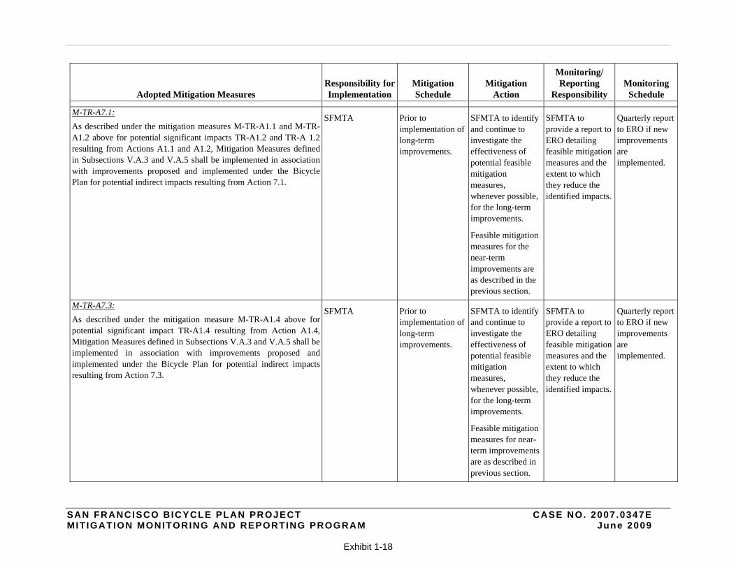
M-TR-A7.1:
As described under the mitigation measures M-TR-A1.1 and M-TR-A1.2 above for potential significant impacts TR-A1.2 and TR-A 1.2 resulting from Actions A1.1 and A1.2, Mitigation Measures defined in Subsections V.A.3 and V.A.5 shall be implemented in association with improvements proposed and implemented under the Bicycle Plan for potential indirect impacts resulting from Action 7.1.
SFMTA Prior to implementation of long-term improvements.
SFMTA to identify and continue to investigate the effectiveness of potential feasible mitigation measures, whenever possible, for the long-term improvements.
Feasible mitigation measures for the near-term improvements are as described in the previous section.
SFMTA to provide a report to ERO detailing feasible mitigation measures and the extent to which they reduce the identified impacts.
Quarterly report to ERO if new improvements are implemented.
M-TR-A7.3:
As described under the mitigation measure M-TR-A1.4 above for potential significant impact TR-A1.4 resulting from Action A1.4, Mitigation Measures defined in Subsections V.A.3 and V.A.5 shall be implemented in association with improvements proposed and implemented under the Bicycle Plan for potential indirect impacts resulting from Action 7.3.
SFMTA Prior to implementation of long-term improvements.
SFMTA to identify and continue to investigate the effectiveness of potential feasible mitigation measures, whenever possible, for the long-term improvements.
Feasible mitigation measures for near-term improvements are as described in previous section.
SFMTA to provide a report to ERO detailing feasible mitigation measures and the extent to which they reduce the identified impacts.
Quarterly report to ERO if new improvements are implemented.
SAN FRANCISCO BICYCLE PLAN PROJECT CASE NO. 2007 .0347E MIT IGATION MONITORING AND REPORTING PROGRAM June 2009
Exhibit 1-19
Adopted Mitigation Measures Responsibility for Implementation
Mitigation Schedule
Mitigation Action
Monitoring/ Reporting
Responsibility Monitoring
Schedule
M-TR-A7.4:
As described under the mitigation measure M-TR-A1.4 for potential indirect impact TR-A1.4 resulting from Action A1.4, Mitigation Measures defined in Subsections V.A.3 and V.A.5 shall be implemented in association with improvements proposed and implemented under the Bicycle Plan to address potential indirect impacts resulting from Action 7.4.
SFMTA Prior to implementation of long-term improvements.
SFMTA to identify and continue to investigate the effectiveness of potential feasible mitigation measures, whenever possible, for the long-term improvements.
Feasible mitigation measures for the near-term improvements are as described in the previous section.
SFMTA to provide a report to ERO detailing feasible mitigation measures and the extent to which they reduce the identified impacts.
Quarterly report to ERO if new improvements are implemented.
M-TR-A8.1:
As described under the mitigation measures M-TR-A1.1 and M-TR-A1.2 above for potential significant impacts TR-A1.2 and TR-A 1.2 resulting from Actions A1.1 and A1.2, Mitigation Measures defined in Subsections V.A.3 and V.A.5 shall be implemented in association with improvements proposed and implemented under the Bicycle Plan to address potential indirect impacts resulting from Action 8.1.
SFMTA Prior to implementation of long-term improvements.
SFMTA to identify and continue to investigate the effectiveness of potential feasible mitigation measures, whenever possible, for the long-term improvements.
Feasible mitigation measures for the near-term improvements are described above.
SFMTA to provide a report to ERO detailing feasible mitigation measures and the extent to which they reduce the identified impacts.
Quarterly report to ERO if new improvements are implemented.
SAN FRANCISCO BICYCLE PLAN PROJECT CASE NO. 2007 .0347E MIT IGATION MONITORING AND REPORTING PROGRAM June 2009
Exhibit 1-20
Adopted Mitigation Measures Responsibility for Implementation
Mitigation Schedule
Mitigation Action
Monitoring/ Reporting
Responsibility Monitoring
Schedule
LONG-TERM IMPROVEMENTS M-TR-LT1.1:
Unsignalized intersections may be signalized, as appropriate. SFMTA Prior to
implementation of Long-term improvement.
SFMTA to implement intersection signalization, where appropriate, as described and to investigate the effectiveness of any potential mitigation measure.
SFMTA to provide a report to ERO detailing feasible mitigation measures and the extent to which they reduce the identified impacts.
Quarterly report to ERO if new improvements are implemented.
M-TR-LT1.2:
Changes may be made to signal timing (including redistributing green time from one phase to another, lengthening of signal cycle times, changing permitted movements to protected movements, signal coordination/ progression), as appropriate.
SFMTA Prior to implementation of Long-term Improvements.
SFMTA to implement changes to signal timing, where appropriate, as described, and to continue to investigate the effectiveness of any potential mitigation measures.
SFMTA to provide a report to ERO detailing feasible mitigation measures and the extent to which they reduce the identified impacts.
Quarterly report to ERO if new improvements are implemented.
M-TR-LT1.3:
Changes may be made to roadway geometry (e.g., changing shared lanes to exclusive turn lanes, proving exclusive right-turn or left-turn pockets), as appropriate.
SFMTA Prior to implementation of Long-term improvements.
SFMTA to implement roadway geometry changes, where appropriate, as described, and to continue to investigate the effectiveness of any potential mitigation measures.
SFMTA to provide a report to ERO detailing feasible mitigation measures and the extent to which they reduce the identified impacts.
Quarterly report to ERO if new improvements are implemented.
SAN FRANCISCO BICYCLE PLAN PROJECT CASE NO. 2007 .0347E MIT IGATION MONITORING AND REPORTING PROGRAM June 2009
Exhibit 1-21
Adopted Mitigation Measures Responsibility for Implementation
Mitigation Schedule
Mitigation Action
Monitoring/ Reporting
Responsibility Monitoring
Schedule
M-TR-LT1.4:
Floating bicycle lanes may be implemented, where on-street parking is restricted during peak periods, to provide for additional vehicular capacity, as appropriate.
SFMTA Prior to implementation of Long-term improvements.
SFMTA to implement floating bicycle lanes appropriate, as described, and to continue to investigate the effectiveness of any potential mitigation measures.
SFMTA to provide a report to ERO detailing feasible mitigation measures and the extent to which they reduce the identified impacts.
Quarterly report to ERO if new improvements are implemented.
M-TR-LT1.5:
Parking may be eliminated to provide for additional vehicular capacity, as appropriate.
SFMTA Prior to implementation of Long-term improvements.
SFMTA to implement parking space removal as described, and to continue to investigate the effectiveness of any potential mitigation measures.
SFMTA to provide a report to ERO detailing feasible mitigation measures and the extent to which they reduce the identified impacts.
Quarterly report to ERO if new improvements are implemented.
M-TR-LT2.1:
Signal pre-emption or other transit priority techniques may be applied to reduce overall transit travel times, as appropriate.
SFMTA Prior to implementation of Long-term improvements.
SFMTA to implement signal pre-emption or other transit priority techniques as described, and to continue to investigate the effectiveness of any potential mitigation measures.
SFMTA to provide a report to ERO detailing feasible mitigation measures and the extent to which they reduce the identified impacts.
Quarterly report to ERO if new improvements are implemented.
SAN FRANCISCO BICYCLE PLAN PROJECT CASE NO. 2007 .0347E MIT IGATION MONITORING AND REPORTING PROGRAM June 2009
Exhibit 1-22
Adopted Mitigation Measures Responsibility for Implementation
Mitigation Schedule
Mitigation Action
Monitoring/ Reporting
Responsibility Monitoring
Schedule
M-TR-LT2.2:
Bicycle proposals may be modified to create discontinuities in bicycle treatment to avoid transit delays, as appropriate.
SFMTA Prior to implementation of Long-term improvements.
SFMTA to create discontinuity in bicycle treatments as described, where appropriate, to facilitate transit operations, and to continue to investigate the effectiveness of any potential mitigation measures.
SFMTA to provide a report to ERO detailing feasible mitigation measures and the extent to which they reduce the identified impacts.
Quarterly report to ERO if new improvements are implemented.
M-TR-LT2.3:
Bus stops may be reconfigured to facilitate bus operations, as appropriate.
SFMTA Prior to implementation of Long-term improvements.
SFMTA to implement bus stops reconfiguration, where appropriate to facilitate bus operations, as described, and to continue to investigate the effectiveness of any potential mitigation measures.
SFMTA to provide a report to ERO detailing feasible mitigation measures and the extent to which they reduce the identified impacts.
Quarterly report to ERO if new improvements are implemented.
SAN FRANCISCO BICYCLE PLAN PROJECT CASE NO. 2007 .0347E MIT IGATION MONITORING AND REPORTING PROGRAM June 2009
Exhibit 1-23
Adopted Mitigation Measures Responsibility for Implementation
Mitigation Schedule
Mitigation Action
Monitoring/ Reporting
Responsibility Monitoring
Schedule
M-TR-LT2.4:
Parking may be eliminated to substitute for lane removal and/or increase roadway capacity, as appropriate.
In some instances, where either existing or projected cumulative conditions at intersections operate at LOS E or LOS F conditions, feasible mitigation measures would not be available, and transit impacts would remain significant and unavoidable.
SFMTA Prior to implementation of Long-term improvements.
SFMTA to determine whether or not parking may be eliminated to substitute for lane removal and/or increase roadway capacity, as described, and to continue to investigate the effectiveness of any potential mitigation measures.
SFMTA to provide a report to ERO detailing feasible mitigation measures and the extent to which they reduce the identified impacts.
Quarterly report to ERO if new improvements are implemented.
M-TR-LT3.1:
Where feasible and required to respond to loading zone impacts, on-street parking layouts shall be modified to accommodate additional yellow commercial freight loading zones.
SFMTA Prior to implementation of Long-term improvements.
SFMTA to determine where on-street parking layouts shall be modified to accommodate additional yellow commercial freight loading zones, where feasible and required, in order to respond to loading zone impacts, as described, and to continue to investigate the effectiveness of any potential mitigation measures.
SFMTA to provide a report to ERO detailing feasible mitigation measures and the extent to which they reduce the identified impacts.
Quarterly report to ERO if new improvements are implemented.
SAN FRANCISCO BICYCLE PLAN PROJECT CASE NO. 2007 .0347E MIT IGATION MONITORING AND REPORTING PROGRAM June 2009
Exhibit 1-24
Adopted Mitigation Measures Responsibility for Implementation
Mitigation Schedule
Mitigation Action
Monitoring/ Reporting
Responsibility Monitoring
Schedule
M-TR-LT3.2:
Traffic management strategies shall be developed and implemented, where feasible, to accommodate short-term passenger loading/unloading activities.
SFMTA Prior to implementation of Long-term improvements.
SFMTA to implement traffic management strategies to accommodate short-term passenger loading/unloading activities, where appropriate, as described, and to continue to investigate the effectiveness of any potential mitigation measures.
SFMTA to provide a report to ERO detailing feasible mitigation measures and the extent to which they reduce the identified impacts.
Quarterly report to ERO if new improvements are implemented.
NEAR-TERM IMPROVEMENTS
Cluster 2: South of Market Area
M-TR-P2-16h:
Feasibility of the following mitigation measures has not yet been determined. There is a range of potential treatments to address the issue at this intersection. One would be repositioning of the bus zone along the south side of Townsend Street. Another treatment would be reconfiguring the approach lanes to the intersection of 4th and Townsend Streets. Finally, installation of discontinuous bicycle lanes at the approach of the intersection could also be considered. Therefore, a significant transit impact would occur with implementation of Project 2-16 Modified Option 1 under Existing plus Project conditions.
SFMTA Prior to implementation of Project 2-16.
SFMTA to implement one of the identified potential treatments as described and to continue to investigate the effectiveness of the potential mitigation measures.
SFMTA to provide a report to ERO detailing feasible mitigation measures and the extent to which they reduce the identified impacts.
Quarterly report to ERO if new improvements are implemented.
SAN FRANCISCO BICYCLE PLAN PROJECT CASE NO. 2007 .0347E MIT IGATION MONITORING AND REPORTING PROGRAM June 2009
Exhibit 1-25
Adopted Mitigation Measures Responsibility for Implementation
Mitigation Schedule
Mitigation Action
Monitoring/ Reporting
Responsibility Monitoring
Schedule
M-TR-P2-16i:
Refer to Mitigation Measure 2-16h above for mitigation of this transit impact. However, without determination of the feasibility of these measures, a significant transit impact would occur to Muni bus line 45 under Existing plus Project conditions for Project 2-16 Modified Option 1.
SFMTA Prior to implementation of Project 2-16.
SFMTA to implement one of the identified potential treatments as described and to continue to investigate the effectiveness of the potential mitigation measures.
SFMTA to provide a report to ERO detailing feasible mitigation measures and the extent to which they reduce the identified impacts.
Quarterly report to ERO if new improvements are implemented.
M-TR-P2-16l:
Refer to Mitigation Measure M-TR-P2-16h above for mitigation of this transit impact. However, without determination of the feasibility of these measures, a significant transit impact would occur to Muni bus line 30 under 2025 Cumulative plus Project conditions for Project 2-16 Modified Option 1.
SFMTA Prior to implementation of Project 2-16.
SFMTA to implement one of the identified potential treatments as described and to continue to investigate the effectiveness of the potential mitigation measures.
SFMTA to provide a report to ERO detailing feasible mitigation measures and the extent to which they reduce the identified impacts
Quarterly report to ERO if new improvements are implemented.
M-TR-P2-16m:
Refer to Mitigation Measure M-TR-P2-16h above for mitigation of this transit impact. However, without determination of the feasibility of these measures, a significant transit impact would occur to Muni bus line 45 under 2025 Cumulative plus Project conditions for Project 2-16 Modified Option 1.
SFMTA Prior to implementation of Project 2-16.
SFMTA to implement one of the identified potential treatments as described and to continue to investigate the effectiveness of the potential mitigation measures.
SFMTA to provide a report to ERO detailing feasible mitigation measures and the extent to which they reduce the identified impacts.
Quarterly report to ERO if new improvements are implemented.
SAN FRANCISCO BICYCLE PLAN PROJECT CASE NO. 2007 .0347E MIT IGATION MONITORING AND REPORTING PROGRAM June 2009
Exhibit 1-26
Adopted Mitigation Measures Responsibility for Implementation
Mitigation Schedule
Mitigation Action
Monitoring/ Reporting
Responsibility Monitoring
Schedule
Cluster 5: Mission/Glen Park/Excelsior Area
M-TR-P5-6a:
Lane configuration adjustments to the eastbound and westbound direction on Cesar Chavez Street would improve LOS and reduce the delay at the Mission Street/Cesar Chavez Street intersection from LOS F to LOS E. The removal of on-street parking along Cesar Chavez Street (applying either Option 1 or 2 per proposed possible Mitigation Measure M-TR-P5-6w in conjunction with proposed possible Mitigation Measures M-TR-P5-6e, M-TR-P5-6h, and M-TR-P5-6j, M-TR-P5-6k, M-TR-P5-6l, M-TR-P5-6m, M-TR-P5-6o, M-TR-P5-6q, for which feasibility has not yet been determined) is proposed which would provide an additional through lane along the eastbound and westbound Cesar Chavez Street approaches. This additional capacity will help reduce the delay and improve the V/C ratio by 9 percent (from 1.31 to 1.18). However, because of the uncertainty of the feasibility of this mitigation measure, a significant impact may occur at the Mission Street/Cesar Chavez Street intersection with the implementation of Project 5-6.
SFMTA Prior to implementation of Project 5-6.
SFMTA to provide lane configuration adjustments corresponding to the No Project conditions with the implementation of one of the two options described in M-TR-P5-6w, and to continue to investigate the effectiveness of the potential mitigation measures as described in the referenced mitigation measures.
SFMTA to provide a report to ERO detailing feasible mitigation measures and the extent to which they reduce the identified impacts.
Quarterly report to ERO if new improvements are implemented.
SAN FRANCISCO BICYCLE PLAN PROJECT CASE NO. 2007 .0347E MIT IGATION MONITORING AND REPORTING PROGRAM June 2009
Exhibit 1-27
Adopted Mitigation Measures Responsibility for Implementation
Mitigation Schedule
Mitigation Action
Monitoring/ Reporting
Responsibility Monitoring
Schedule
M-TR-P5-6b:
Lane configuration adjustments to the eastbound and westbound directions on Cesar Chavez Street would improve LOS and reduce the delay at the Mission Street/Cesar Chavez Street intersection. The removal of on-street parking along Cesar Chavez Street (applying either Option 1 or 2 per proposed possible Mitigation Measure M-TR-P6-5w in conjunction with proposed possible Mitigation Measures, M-TR-P5-6e, M-TR-P5-6h, and M-TR-P5-6j, M-TR-P5-6k, M-TR-P5-6l, M-TR-P5-6m, M-TR-P5-6o, M-TR-P5-6q, for which feasibility has not yet been determined) is proposed which would provide an additional through lane along the eastbound and westbound Cesar Chavez Street approaches. This additional capacity will help reduce the delay and improve the V/C ratio by 23 percent (from 1.17 to 0.90). However, because of the uncertainty of the feasibility of this mitigation measure, a significant impact would occur at the Mission Street/Cesar Chavez Street intersection with the implementation of Project 5-6.
SFMTA Prior to implementation of Project 5-6.
SFMTA to provide lane configuration adjustments corresponding to the No Project conditions with the implementation of one of the two options described in M-TR-P5-6w, and to continue to investigate the effectiveness of the potential mitigation measures as described in the referenced mitigation measures.
SFMTA to provide a report to ERO detailing feasible mitigation measures and the extent to which they reduce the identified impacts.
Quarterly report to ERO if new improvements are implemented.
SAN FRANCISCO BICYCLE PLAN PROJECT CASE NO. 2007 .0347E MIT IGATION MONITORING AND REPORTING PROGRAM June 2009
Exhibit 1-28
Adopted Mitigation Measures Responsibility for Implementation
Mitigation Schedule
Mitigation Action
Monitoring/ Reporting
Responsibility Monitoring
Schedule
M-TR-P5-6c:
Lane configuration adjustments to the westbound direction of Cesar Chavez Street would improve LOS and reduce the delay for the Guerrero Street/Cesar Chavez Street. The removal of on-street parking along Cesar Chavez Street (applying either Option 1 or 2 per proposed possible Mitigation M-TR-P5-6w in conjunction with proposed possible Mitigation Measures, M-TR-P5-6e, M-TR-P5-6h, and M-TR-P5-6j, M-TR-P5-6k, M-TR-P5-6l, M-TR-P5-6m, M-TR-P5-6o, M-TR-P5-6q, for which feasibility has not yet been determined) is proposed which would provide an additional through lane along the westbound Cesar Chavez Street approach. This lane adjustment would decrease the delay and improve the V/C ratio by 28 percent (from 1.23 to 0.88) and improve LOS from F to D. However, because of the uncertainty of the feasibility of this mitigation measure, a significant impact may occur at the Guerrero Street/Cesar Chavez Street intersection with the implementation of Project 5-6.
SFMTA Prior to implementation of Project 5-6.
SFMTA to provide lane configuration adjustments corresponding to the No Project conditions with the implementation of one of the two options described in M-TR-P5-6w, and to continue to investigate the effectiveness of the potential mitigation measures as described in the referenced mitigation measures.
SFMTA to provide a report to ERO detailing feasible mitigation measures and the extent to which they reduce the identified impacts.
Quarterly report to ERO if new improvements are implemented.
SAN FRANCISCO BICYCLE PLAN PROJECT CASE NO. 2007 .0347E MIT IGATION MONITORING AND REPORTING PROGRAM June 2009
Exhibit 1-29
Adopted Mitigation Measures Responsibility for Implementation
Mitigation Schedule
Mitigation Action
Monitoring/ Reporting
Responsibility Monitoring
Schedule
M-TR-P5-6e
Lane configuration adjustments to the westbound direction along Cesar Chavez Street would improve LOS and reduce the delay at the Guerrero Street/Cesar Chavez Street intersection. The removal of on-street parking along Cesar Chavez Street (applying either Option 1 or 2 per proposed possible Mitigation Measure M-TR-5-6w in conjunction with proposed possible Mitigation Measures, M-TR-P5-6e, M-TR-P5-6h, and M-TR-P5-6j, M-TR-P5-6k, M-TR-P5-6l, M-TR-P5-6m, M-TR-P5-6o, M-TR-P5-6q, for which feasibility has not yet been determined) is proposed which would provide an additional through lane along the westbound approach of Cesar Chavez Street. This lane adjustment would decrease the delay and improve the V/C ratio by 26 percent (from 1.76 to 1.30). Nevertheless, this mitigation measure would not reduce the project impacts at Guerrero Street/Cesar Chavez Street to a less-than-significant level.
SFMTA Prior to implementation of Project 5-6.
SFMTA to provide lane configuration adjustments corresponding to the No Project conditions with the implementation of one of the two options described in M-TR-P5-6w, and to continue to investigate the effectiveness of the potential mitigation measures as described in the referenced mitigation measures.
SFMTA to provide a report to ERO detailing feasible mitigation measures and the extent to which they reduce the identified impacts.
Quarterly report to ERO if new improvements are implemented.
SAN FRANCISCO BICYCLE PLAN PROJECT CASE NO. 2007 .0347E MIT IGATION MONITORING AND REPORTING PROGRAM June 2009
Exhibit 1-30
Adopted Mitigation Measures Responsibility for Implementation
Mitigation Schedule
Mitigation Action
Monitoring/ Reporting
Responsibility Monitoring
Schedule
M-TR-P5-6h:
Lane configuration adjustments to the eastbound and westbound directions along Cesar Chavez Street would improve LOS and reduce the delay at the Mission Street/Cesar Chavez Street intersection. It is proposed that on-street parking be removed from Cesar Chavez Street (applying either Option 1 or 2 per proposed possible Mitigation Measure M-TR-P5-6w in conjunction with proposed possible Mitigation Measures, M-TR-P5-6e, M-TR-P5-6h, and M-TR-P5-6j, M-TR-P5-6k, M-TR-P5-6l, M-TR-P5-6m, M-TR-P5-6o, M-TR-P5-6q, for which feasibility has not yet been determined, along Cesar Chavez Street in eastbound and westbound directions which would provide an additional through lane in both directions. These lane adjustments would decrease the delay and improve LOS from E to D. However, because of the uncertainty of the feasibility of this mitigation measure, a significant impact would occur at the Mission Street/Cesar Chavez Street intersection with the implementation of Project 5-6. In addition, bicycle lane discontinuity could occur at this location.
SFMTA Prior to implementation of Project 5-6.
SFMTA to provide lane configuration adjustments corresponding to the No Project conditions with the implementation of one of the two options described in M-TR-P5-6w, and to continue to investigate the effectiveness of the potential mitigation measures as described in the referenced mitigation measures.
SFMTA to provide a report to ERO detailing feasible mitigation measures and the extent to which they reduce the identified impacts.
Quarterly report to ERO if new improvements are implemented.
SAN FRANCISCO BICYCLE PLAN PROJECT CASE NO. 2007 .0347E MIT IGATION MONITORING AND REPORTING PROGRAM June 2009
Exhibit 1-31
Adopted Mitigation Measures Responsibility for Implementation
Mitigation Schedule
Mitigation Action
Monitoring/ Reporting
Responsibility Monitoring
Schedule
M-TR-P5-6j:
Lane configuration adjustments to the eastbound and westbound directions along Cesar Chavez Street would improve LOS and reduce the delay at the Mission Street/Cesar Chavez Street intersection. It is proposed that on-street parking be removed from Cesar Chavez Street (applying either Option 1 or 2 per proposed possible Mitigation Measure M-TR-5-6w in conjunction with proposed possible Mitigation Measures, M-TR-P5-6e, M-TR-P5-6h, and M-TR-P5-6j, M-TR-P5-6k, M-TR-P5-6l, M-TR-P5-6m, M-TR-P5-6o, M-TR-P5-6q, for which feasibility has not yet been determined) along Cesar Chavez Street in the eastbound and westbound directions which would provide an additional through lane in both directions. These lane adjustments would decrease the delay and improve LOS from F to E. However, because of the uncertainty of the feasibility of this mitigation measure, a significant impact would occur at the Mission Street/Cesar Chavez Street intersection with the implementation of Project 5-6.
SFMTA Prior to implementation of Project 5-6.
SFMTA to provide lane configuration adjustments corresponding to the No Project conditions with the implementation of one of the two options described in M-TR-P5-6w, and to continue to investigate the effectiveness of the potential mitigation measures as described in the referenced mitigation measures.
SFMTA to provide a report to ERO detailing feasible mitigation measures and the extent to which they reduce the identified impacts.
Quarterly report to ERO if new improvements are implemented.
SAN FRANCISCO BICYCLE PLAN PROJECT CASE NO. 2007 .0347E MIT IGATION MONITORING AND REPORTING PROGRAM June 2009
Exhibit 1-32
Adopted Mitigation Measures Responsibility for Implementation
Mitigation Schedule
Mitigation Action
Monitoring/ Reporting
Responsibility Monitoring
Schedule
M-TR-P5-6k:
Lane configuration adjustments to the eastbound and westbound directions along Cesar Chavez Street would improve LOS and reduce the delay at the Cesar Chavez Street/South Van Ness Avenue intersection. It is proposed that on-street parking along Cesar Chavez Street be removed (applying either Option 1 or 2 per proposed possible Mitigation Measure M-TR-5-6w in conjunction with proposed possible Mitigation Measures, M-TR-P5-6e, M-TR-P5-6h, and M-TR-P5-6j, M-TR-P5-6k, M-TR-P5-6l, M-TR-P5-6m, M-TR-P5-6o, M-TR-P5-6q, for which feasibility has not yet been determined) in both the eastbound and westbound directions on Cesar Chavez Street, which would provide an additional through lane along both approaches. These lane adjustments would decrease the delay and improve LOS from F to D. However, because of the uncertainty of the feasibility of this mitigation measure, a significant impact would occur at the Cesar Chavez Street/South Van Ness Avenue intersection with the implementation of Project 5-6.
SFMTA Prior to implementation of Project 5-6.
SFMTA to provide lane configuration adjustments corresponding to the No Project conditions with the implementation of one of the two options described in M-TR-P5-6w, and to continue to investigate the effectiveness of the potential mitigation measures as described in the referenced mitigation measures.
SFMTA to provide a report to ERO detailing feasible mitigation measures and the extent to which they reduce the identified impacts.
Quarterly report to ERO if new improvements are implemented.
SAN FRANCISCO BICYCLE PLAN PROJECT CASE NO. 2007 .0347E MIT IGATION MONITORING AND REPORTING PROGRAM June 2009
Exhibit 1-33
Adopted Mitigation Measures Responsibility for Implementation
Mitigation Schedule
Mitigation Action
Monitoring/ Reporting
Responsibility Monitoring
Schedule
M-TR-P5-6l:
Lane configuration adjustments to the westbound direction along Cesar Chavez Street would improve LOS and reduce the delay at the Cesar Chavez Street/South Van Ness Avenue intersection. It is proposed that on-street parking along Cesar Chavez Street be removed (applying either Option 1 or 2 per proposed possible Mitigation Measure M-TR-5-6w in conjunction with proposed possible Mitigation Measures, M-TR-P5-6e, M-TR-P5-6h, and M-TR-P5-6j, M-TR-P5-6k, M-TR-P5-6l, M-TR-P5-6m, M-TR-P5-6o, M-TR-P5-6q, for which feasibility has not yet been determined) in the westbound direction which would provide an additional through lane along this approach. This lane adjustment would decrease the delay and improve LOS from E to D. However, because of the uncertainty of the feasibility of this mitigation measure, a significant impact would occur at the Cesar Chavez Street/South Van Ness Avenue intersection with the implementation of Project 5-6.
SFMTA Prior to implementation of Project 5-6.
SFMTA to provide lane configuration adjustments corresponding to the No Project conditions with the implementation of one of the two options described in M-TR-P5-6w, and to continue to investigate the effectiveness of the potential mitigation measures as described in the referenced mitigation measures.
SFMTA to provide a report to ERO detailing feasible mitigation measures and the extent to which they reduce the identified impacts.
Quarterly report to ERO if new improvements are implemented.
SAN FRANCISCO BICYCLE PLAN PROJECT CASE NO. 2007 .0347E MIT IGATION MONITORING AND REPORTING PROGRAM June 2009
Exhibit 1-34
Adopted Mitigation Measures Responsibility for Implementation
Mitigation Schedule
Mitigation Action
Monitoring/ Reporting
Responsibility Monitoring
Schedule
M-TR-P5-6m:
Lane configuration adjustments to the eastbound direction and westbound direction on Cesar Chavez Street would improve LOS and reduce the delay at the Cesar Chavez Street/South Van Ness intersection. It is proposed that on- street parking along Cesar Chavez Street be removed (applying either Option 1 or 2 per proposed possible Mitigation Measure M-TR-5-6w conjunction with proposed possible Mitigation Measures, M-TR-P5-6e, M-TR-P5-6h, and M-TR-P5-6j, M-TR-P5-6k, M-TR-P5-6l, M-TR-P5-6m, M-TR-P5-6o, M-TR-P5-6q, for which feasibility has not yet been determined) in both the eastbound and westbound directions on Cesar Chavez Street, which would provide an additional through lane along both approaches. These lane adjustments decrease the amount of average delay and reduce the V/C ratio by 22 percent (from 1.91 to 1.49). Nevertheless, this mitigation measure would not reduce the project impacts to a less-than-significant level.
SFMTA Prior to implementation of Project 5-6.
SFMTA to provide lane configuration adjustments corresponding to the No Project conditions with the implementation of one of the two options described in M-TR-P5-6w, and to continue to investigate the effectiveness of the potential mitigation measures as described in the referenced mitigation measures.
SFMTA to provide a report to ERO detailing feasible mitigation measures and the extent to which they reduce the identified impacts.
Quarterly report to ERO if new improvements are implemented.
SAN FRANCISCO BICYCLE PLAN PROJECT CASE NO. 2007 .0347E MIT IGATION MONITORING AND REPORTING PROGRAM June 2009
Exhibit 1-35
Adopted Mitigation Measures Responsibility for Implementation
Mitigation Schedule
Mitigation Action
Monitoring/ Reporting
Responsibility Monitoring
Schedule
M-TR-P5-6o:
Lane configuration adjustments to the eastbound direction and westbound direction along Cesar Chavez Street would improve LOS and reduce the delay at the Bryant Street/Cesar Chavez Street intersection. It is proposed that on-street parking be removed along the eastbound and westbound directions on Cesar Chavez Street (applying either Option 1 or 2 per proposed possible Mitigation Measure M-TR-5-6w in conjunction with proposed possible Mitigation Measures, M-TR-P5-6e, M-TR-P5-6h, and M-TR-P5-6j, M-TR-P5-6k, M-TR-P5-6l, M-TR-P5-6m, M-TR-P5-6o, M-TR-P5-6q, for which feasibility has not yet been determined), which would provide an additional through lane in both directions. These lane adjustments would decrease the delay and improve the V/C ratio by 29 percent (from 1.34 to 0.95) and improve LOS from F to D. However, because of the uncertainty of the feasibility of this mitigation measure, a significant impact would occur at the Bryant Street/Cesar Chavez Street intersection with the implementation of Project 5-6.
SFMTA Prior to implementation of Project 5-6.
SFMTA to provide lane configuration adjustments corresponding to the No Project conditions with the implementation of one of the two options described in M-TR-P5-6w, and to continue to investigate the effectiveness of the potential mitigation measures as described in the referenced mitigation measures.
SFMTA to provide a report to ERO detailing feasible mitigation measures and the extent to which they reduce the identified impacts.
Quarterly report to ERO if new improvements are implemented.
SAN FRANCISCO BICYCLE PLAN PROJECT CASE NO. 2007 .0347E MIT IGATION MONITORING AND REPORTING PROGRAM June 2009
Exhibit 1-36
Adopted Mitigation Measures Responsibility for Implementation
Mitigation Schedule
Mitigation Action
Monitoring/ Reporting
Responsibility Monitoring
Schedule
M-TR-P5-6q:
Lane configuration adjustments to the eastbound and westbound directions along Cesar Chavez Street would improve LOS and reduce the delay at the Bryant Street/Cesar Chavez Street intersection. It is proposed that on-street parking be removed in the eastbound and westbound directions along Cesar Chavez Street (applying either Option 1 or 2 per proposed possible Mitigation Measure M-TR-5-6w in conjunction with proposed possible Mitigation Measures, M-TR-P5-6e, M-TR-P5-6h, and M-TR-P5-6j, M-TR-P5-6k, M-TR-P5-6l, M-TR-P5-6m, M-TR-P5-6o, M-TR-P5-6q, for which feasibility has not yet been determined), which would provide an additional through lane along both approaches. These lane adjustments would decrease the delay and improve the V/C ratio by 28 percent (from 2.04 to 1.47). Nevertheless, this mitigation measure Chavez Street intersection with the implementation of Project 5-6. would not reduce the project impacts to a less-than-significant level. Hence a significant impact would occur at the Bryant Street/Cesar Chavez Streets.
SFMTA Prior to implementation of Project 5-6.
SFMTA to provide lane configuration adjustments corresponding to the No Project conditions with the implementation of one of the two options described in M-TR-P5-6w, and to continue to investigate the effectiveness of the potential mitigation measures as described in the referenced mitigation measures.
SFMTA to provide a report to ERO detailing feasible mitigation measures and the extent to which they reduce the identified impacts.
Quarterly report to ERO if new improvements are implemented.
SAN FRANCISCO BICYCLE PLAN PROJECT CASE NO. 2007 .0347E MIT IGATION MONITORING AND REPORTING PROGRAM June 2009
Exhibit 1-37
Adopted Mitigation Measures Responsibility for Implementation
Mitigation Schedule
Mitigation Action
Monitoring/ Reporting
Responsibility Monitoring
Schedule
M-TR-P5-6s:
The implementation of Modified Option 1 under Existing plus Project conditions would add 474 seconds (7.9 minutes) of total delay for Muni bus line 12 westbound. With mitigation as described in Mitigation Measure M-TR-P5-6w in conjunction with proposed possible Mitigation Measures, M-TR-P5-6e, M-TR-P5-6h, and M-TR-P5-6j, M-TR-P5-6k,.M-TR-P5-6l, M-TR-P5-6m, M-TR-P5-6o, M-TR-P5-6q, for which feasibility has not yet been determined, this delay would be reduced to 262 seconds (4.4 minutes) of delay westbound for Muni bus line 12. This would reduce total delay below the transit delay threshold of six minutes. However, because of the uncertainty of the feasibility of this mitigation measure, a significant impact would occur to Muni bus line 12 for Project 5-6 Modified Option 1 under Existing plus Project conditions.
SFMTA Prior to implementation of Project 5-6 Option 1.
SFMTA to provide lane configuration adjustments corresponding to the No Project conditions with the implementation of one of the two options described in M-TR-P5-6w, and to continue to investigate the effectiveness of the potential mitigation measures as described in the referenced mitigation measures.
SFMTA to provide a report to ERO detailing feasible mitigation measures and the extent to which they reduce the identified impacts.
Quarterly report to ERO if new improvements are implemented.
SAN FRANCISCO BICYCLE PLAN PROJECT CASE NO. 2007 .0347E MIT IGATION MONITORING AND REPORTING PROGRAM June 2009
Exhibit 1-38
Adopted Mitigation Measures Responsibility for Implementation
Mitigation Schedule
Mitigation Action
Monitoring/ Reporting
Responsibility Monitoring
Schedule
M-TR-P5-6t:
The implementation of Option 1 under Existing plus Project conditions would add 867 seconds (14.5 minutes) of total delay for Muni bus line 27. With mitigation as described in Mitigation Measure M-TR-P5-6w in conjunction with proposed possible Mitigation Measures, M-TR-P5-6e, M-TR-P5-6h, and M-TR-P5-6j, M-TR-P5-6k, M-TR-P5-6l, M-TR-P5-6m, M-TR-P5-6o, M-TR-P5-6q, for which feasibility has not yet been determined, delay in the westbound direction would be reduced to 324 seconds (5.4 minutes) of delay westbound and 29 seconds eastbound for a total added delay of 353 seconds (5.8 minutes). This would reduce total delay below the transit delay threshold of six minutes. However, because of the uncertainty of the feasibility of this mitigation measure, a significant impact would occur to Muni bus line 27 for Project 5-6 Option 1 under Existing plus Project conditions.
SFMTA Prior to implementation of Project 5-6 Option 1.
SFMTA to provide lane configuration adjustments corresponding to the No Project conditions with the implementation of one of the two options described in M-TR-P5-6w, and to continue to investigate the effectiveness of the potential mitigation measures as described in the referenced mitigation measures.
SFMTA to provide a report to ERO detailing feasible mitigation measures and the extent to which they reduce the identified impacts.
Quarterly report to ERO if new improvements are implemented.
SAN FRANCISCO BICYCLE PLAN PROJECT CASE NO. 2007 .0347E MIT IGATION MONITORING AND REPORTING PROGRAM June 2009
Exhibit 1-39
Adopted Mitigation Measures Responsibility for Implementation
Mitigation Schedule
Mitigation Action
Monitoring/ Reporting
Responsibility Monitoring
Schedule
M-TR-P5-6u:
The implementation of Option 1 under 2025 Cumulative plus Project conditions would add approximately 1,487 seconds (24.7 minutes) of total delay for Muni bus line 12 westbound with mitigation as described in Mitigation Measure M-TR-P5-6w in conjunction with proposed possible Mitigation Measures, M-TR-P5-6e, M-TR-P5-6h, and M-TR-P5-6j, M-TR-P5-6k, M-TR-P5-6l, M-TR-P5-6m, M-TR-P5-6o, M-TR- P5-6q, for which feasibility has not yet been determined. Therefore, a significant transit impact to Muni bus line 12 would occur with implementation of Project 5-6 with Option 1 under 2025 Cumulative plus Project conditions.
SFMTA Prior to implementation of Project 5-6 Option 1.
SFMTA to provide lane configuration adjustments corresponding to the No Project conditions with the implementation of one of the two options described in M-TR-P5-6w, and to continue to investigate the effectiveness of the potential mitigation measures as described in the referenced mitigation measures.
SFMTA to provide a report to ERO detailing feasible mitigation measures and the extent to which they reduce the identified impacts.
Quarterly report to ERO if new improvements are implemented.
SAN FRANCISCO BICYCLE PLAN PROJECT CASE NO. 2007 .0347E MIT IGATION MONITORING AND REPORTING PROGRAM June 2009
Exhibit 1-40
Adopted Mitigation Measures Responsibility for Implementation
Mitigation Schedule
Mitigation Action
Monitoring/ Reporting
Responsibility Monitoring
Schedule
M-TR-P5-6v:
The implementation of Option 1 under 2025 Cumulative plus Project conditions would add approximately 2,429 seconds (40.5 minutes) of total delay for Muni bus line 27. With mitigation as described in Mitigation Measure M-TR-P5-6w in conjunction with proposed possible Mitigation Measures, M-TR-P5-6e, M-TR-P5-6h, and M-TR-P5-6j, M-TR-P5-6k, M-TR-P5-6l, M-TR-P5-6m, M-TR-P5-6o, M-TR-P5-6q, for which feasibility has not yet been determined, this delay would not be reduced westbound but would be reduced to 99 seconds (1.6 minutes) of delay eastbound. The total added delay of 1,897 seconds (31.6 minutes) would be greater than the transit delay threshold of six minutes. Therefore, a significant transit impact to Muni bus line 27 would occur with implementation of Project 5-6 with Option 1 under 2025 Cumulative plus Project conditions.
SFMTA Prior to implementation of Project 5-6 Option 1.
SFMTA to provide lane configuration adjustments corresponding to the No Project conditions with the implementation of one of the two options described in M-TR-P5-6w, and to continue to investigate the effectiveness of the potential mitigation measures as described in the referenced mitigation measures.
SFMTA to provide a report to ERO detailing feasible mitigation measures and the extent to which they reduce the identified impacts.
Quarterly report to ERO if new improvements are implemented.
SAN FRANCISCO BICYCLE PLAN PROJECT CASE NO. 2007 .0347E MIT IGATION MONITORING AND REPORTING PROGRAM June 2009
Exhibit 1-41
Adopted Mitigation Measures Responsibility for Implementation
Mitigation Schedule
Mitigation Action
Monitoring/ Reporting
Responsibility Monitoring
Schedule
M-TR-P5-6w:
As referenced in the above Mitigation Measures M-TR-P5-6e, M-TR-P5-6h, M-TR-P 5-6j, M-TR-P 5-6k, M-TR-P 5-6l, M-TR-P 5-6m, M-TR-P 5-6o, and M-TR-P 5-6q, the traffic analysis conducted for Project 5-6 included four study intersections along Cesar Chavez for the segment between Hampshire and Guerrero Streets. Analysis indicates that if the lane configurations corresponding to the No Project conditions can be provided, some impacts will be mitigated at these intersections. The following two options are part of proposed possible mitigation measures, for which feasibility has not yet been determined, to reinstate the lane configuration under No Project conditions.
Option 1
Removal of parking – For the four study intersections analyzed, approximately 100 spaces would need to be removed on Cesar Chavez Street to mitigate the impacts at these locations. However, additional parking spaces may need to be removed to reduce impacts along the entire corridor.
Option 2
Implementing a discontinuous bicycle lane – The consultant recommends the bicycle lane be discontinued at selected intersection approaches along Cesar Chavez Street. This option may reduce the number of parking spaces that need to be removed on Cesar Chavez Street compared to Option 1.
SFMTA Prior to implementation of Project 5-6.
SFMTA to provide lane configuration adjustments corresponding to the No Project conditions with the implementation of one of the two options described in M-TR-P5-6w, and to continue to investigate the effectiveness of the potential mitigation measures as described in the referenced mitigation measures.
SFMTA to provide a report to ERO detailing feasible mitigation measures and the extent to which they reduce the identified impacts.
Quarterly report to ERO if new improvements are implemented.
Adopted Improvement Measures
Implementation
Responsibility
Schedule
Action
Monitoring/ Reporting
Responsibility
Monitoring
Schedule
B-1 IMPROVEMENT MEASURES AGREED TO BY PROJECT SPONSOR RELATED TO THE NEAR-TERM IMPROVEMENTS:
I-P2-1a: To improve freight loading conditions in the 2nd Street corridor, metered parking spaces on Mission Street east of 2nd Street would be converted to yellow commercial freight loading zones.
.
SFMTA Prior to implementa-tion of Modified Project 2-1.
SFMTA to convert metered parking spaces immediately adjacent to the two commercial freight loading zones on the west side of Hawthorne Street north of Folsom Street on 2nd Street would be converted to yellow commercial freight loading zones.
SFMTA to provide a report to ERO detailing the implementation of improvement measures.
Quarterly report to ERO as new improvements are implemented.
Adopted Improvement Measures
Implementation
Responsibility
Schedule
Action
Monitoring/ Reporting
Responsibility
Monitoring
Schedule
I-P2-1b: To improve freight loading conditions in the 2nd Street corridor, two metered parking spaces immediately adjacent to the aforementioned commercial freight loading spaces on Hawthorne Street would be converted to yellow commercial freight loading spaces.
SFMTA Prior to implementa-tion of Modified Project 2-1.
SFMTA to convert two metered parking spaces immediately adjacent to the aforementioned commercial freight loading spaces on Hawthorne Street to yellow commercial freight loading spaces.
SFMTA to provide a report to ERO detailing the implementation of improvement measures.
Quarterly report to ERO as new improvements are implemented.
I-P2-4a:
In order to address improvements for the non-significant parking impacts resulting from the loss of on-street parking spaces under Existing plus Project and 2025 Cumulative plus Project Conditions, it is recommended that the existing parallel parking on some cross streets along 17th Street is converted to perpendicular parking. This improvement measure would reduce the net parking loss from 212 to 166 parking spaces.
SFMTA Prior to implementa-tion of Modified Project 2-4
SFMTA to investigate conversion of existing parallel parking on some cross streets along 17th Street along the project alignment to perpendicular parking.
SFMTA to provide a report to ERO detailing the implementation of improvement measures.
Quarterly report to ERO as new improvements are implemented.
Adopted Improvement Measures
Implementation
Responsibility
Schedule
Action
Monitoring/ Reporting
Responsibility
Monitoring
Schedule
I-P2-11a:
In order to address improvements for the non-significant loading impacts resulting from the loss of on-street loading spaces under Existing plus Project and 2025 Cumulative plus Project conditions, it is recommended that the City conduct a loading needs analysis to determine how many and where additional on-street yellow commercial freight loading spaces are required on or near Market Street between Laguna and Noe Streets.
SFMTA Prior to implementa-tion of Modified Project 2-11
SFMTA to conduct a loading needs analysis to determine how many and where additional on-street yellow commercial freight loading spaces are required on or near Market Street between Laguna and Noe Streets.
SFMTA to provide a report to ERO detailing the implementation of improvement measures.
Quarterly report to ERO as new improvements are implemented.
I-P5-7a:
This improvement measure is recommended to improve parking conditions with implementation of Project 5-7. The second phase design study for the Glen Park Station area conducted by the SFMTA could further investigate parking management strategies in this area, such as parking pricing, better striping and potential expansion of the existing parking lot on the north side of Bosworth Street. The Glen Park neighborhood has been working closely with the City on the development of a transportation concept plan for this area. It should consider potential loss of an additional 56 to 59 parking spaces due to the proposed bicycle improvements and identify acceptable strategies with the neighborhood organizations to address the issue of parking loss.
SFMTA Prior to implementa-tion of Project 5-7a
SFMTA could further investigate parking management strategies in this area, such as parking pricing, better striping and potential expansion of the existing parking lot on the north side of Bosworth Street.
SFMTA to provide a report to ERO detailing the implementation of improvement measures.
Quarterly report to ERO as new improvements are implemented.
Adopted Improvement Measures
Implementation
Responsibility
Schedule
Action
Monitoring/ Reporting
Responsibility
Monitoring
Schedule
B-2 IMPROVEMENT MEASURES RELATED TO THE LONG-TERM IMPROVEMENTS FOR WHICH FEASIBILITY HAS YET TO BE
DETERMINED
I-TR-LT3.1:
Converting metered parking to yellow commercial freight loading zones, where feasible.
SFMTA Prior to implementa-tion of a long-term improvement
SFMTA to determine locations to convert metered parking to yellow commercial freight loading zones, where appropriate. and feasible.
SFMTA to provide a report to ERO detailing the implementation of improvement measures.
Quarterly report to ERO as new improvements are implemented.
I-TR-LT3.2:
Developing and implementing traffic management strategies to accommodate short-term passenger loading/unloading activities, where feasible.
SFMTA Prior to implementa-tion of a long-term improvement
SFMTA to develop and implement traffic management strategies to accommodate short-term passenger loading/unloading activities, where appropriate and feasible.
SFMTA to provide a report to ERO detailing the implementation of improvement measures.
Quarterly report to ERO as new improvements are implemented.
Enclosure 4 2009 Bike Plan Near-Term Projects Update April 15, 2013 Projects Completed Pre-Injunction (2.7 miles) 1. 14th Street eastbound bicycle lane, Dolores Street to Market Street 2. Market Street bicycle lanes, Octavia Boulevard to Van Ness Avenue 3. “Wiggle” bicycle improvements 4. Alemany Boulevard bicycle lanes, Rousseau Street to San Jose Avenue Projects Completed after the May 2008 Injunction Modification (0.0 miles) 5. Fell Street and Masonic Avenue intersection improvements Projects Completed after the November 2009 Injunction Modification (2.0 miles) 6. Beale Street southbound bicycle lane, Bryant Street to Folsom Street 7. Howard Street westbound bicycle lane, short extension at 9th Street 8. Scott Street Northbound left-turn bicycle lane, Fell Street to Oak Street 9. Mississippi Street bicycle lanes, 16th Street to Mariposa Street
10. Claremont Boulevard bicycle lanes, Dewey Boulevard to Portola Drive 11. Clipper Street bicycle lanes, Douglass Street to Portola Drive 12. Kansas Street bicycle lanes, 23rd Street to 26th Street 13. Otis Street westbound bicycle lane, Gough Street to South Van Ness Avenue 14. 7th Avenue bicycle lanes/sharrows, Lawton Street to Lincoln Way Projects Completed since the August 2010 Injunction Dissolution (21.5 miles) 15. 19th Avenue mixed-use path, Buckingham Way to Holloway Avenue 16. Buckingham Way bicycle lanes, 19th Avenue to 20th Avenue 17. North Point Street bicycle lanes, The Embarcadero to Van Ness Avenue 18. Laguna Honda Boulevard bicycle lanes, Clarendon Avenue to Woodside Avenue 19. Townsend Street bicycle lanes, 4th Street to The Embarcadero 20. Kirkham Street bicycle lanes, 6th Avenue to Great Highway 21. Ocean Avenue bicycle lanes, Alemany Boulevard to Lee Avenue 22. Division Street bicycle lanes, 9th Street to 11th Street 23. Laguna Honda Boulevard bicycle lanes, Portola Drive to Woodside Avenue 24. Glen Park Area bicycle lanes, including connections between Alemany Blvd and San Jose Avenue, and between Monterey
Boulevard and San Jose Avenue 25. 17th Street Corridor bicycle lanes and shared use lane markings, Corbett Avenue to Kansas Street, including connections to
16th Street BART Station via Hoff and to Division Street via Potrero Avenue 26. Market Street bicycle lanes, 17th Street to Octavia Boulevard 27. Alemany Boulevard bicycle lanes, Bayshore Boulevard to Rousseau Street 28. McAllister Street bicycle lanes, Market Street to Masonic Avenue 29. Sagamore Street and Sickles Avenue bicycle lanes, Alemany Boulevard to Brotherhood Way 30. Phelan Avenue bicycle lanes, Judson Avenue to Ocean Avenue 31. Illinois Street bicycle lanes, 16th Street to Cargo Way 32. Potrero Avenue bicycle lanes, 25th Street to Cesar Chavez Street 33. Holloway Avenue bicycle lanes, Junipero Serra Boulevard to Varela Avenue 34. McCoppin Street bicycle path, Market Street to Valencia Street 35. Portola Drive bicycle lanes, Corbett Avenue to O’Shaughnessy Boulevard 36. Portola Drive bicycle lanes, O’Shaughnessy Boulevard to Sloat Boulevard 37. John F. Kennedy Drive separated bikeways, Kezar Drive to Transverse Drive
38. Bayshore Boulevard bicycle lanes, Cesar Chavez Street to Silver Avenue 39. Cesar Chavez Street bicycle lanes, I-280 to US 101 40. Broadway Tunnel signage improvements (includes bike detection, flashing beacon and warning sign for the EB approach) 41. Page and Stanyan Streets intersection traffic signal improvements 42. 23rd Street bicycle lanes, Kansas Street to Potrero Avenue 43. Howard Street westbound bicycle lane, The Embarcadero to Fremont Street 44. Cargo Way bicycle lanes, 3rd Street to Jennings Street 45. Market and Valencia Streets intersection traffic signal improvements 46. John Muir Drive separated bikeways, Lake Merced Blvd to Skyline Boulevard Projects Remaining (7.6 miles) 1. McCoppin Street, Gough Street to Valencia Street 2. Bayshore Boulevard (formerly San Bruno Avenue) bicycle lanes, Paul Avenue to Silver Avenue 3. Great Highway and Point Lobos Avenue bicycle lanes, Cabrillo Street to El Camino del Mar 4. Cesar Chavez/26th Streets corridor bicycle lanes, Sanchez Street to US-101 5. Sloat Boulevard bicycle lanes, The Great Highway to Skyline Boulevard 6. Polk Street northbound contraflow bicycle lane, Market Street to McAllister Street 7. 7th Avenue at Lincoln Way intersection traffic signal improvements 8. Masonic Avenue bicycle lanes, Fell Street to Geary Boulevard 9. Fremont Street southbound bicycle lane, Folsom Street to Harrison Street 10. 2nd Street bicycle lanes, King Street to Market Street 11. 16th Street bicycle lanes, 3rd Street to Terry A. Francois Boulevard 12. 5th Street bicycle lanes, Market Street to Townsend Street 13. Broadway bicycle lanes, Polk Street to Webster Street 14. Innes Avenue bicycle lanes, Donahue Street to Hunters Point Boulevard