45
Palmerston North City District Plan Sectional District Plan Review Proposed Plan Change 7 Roading Hierarchy November 2011
| Date post: | 27-Apr-2018 |
| Category: |
Documents |
| Upload: | nguyentruc |
| View: | 216 times |
| Download: | 1 times |

Palmerston North City District Plan
Sectional District Plan Review
Proposed Plan Change 7
Roading Hierarchy
November 2011

i
Contents Part I – Proposed Plan Change 1 1 Description of Proposed Plan Change 1 2 Proposed amendments to Section 20 of the District Plan 1 Part II – Section 32 Report 16 1 Introduction 16 2 Plan Change Objective 16 3 Reason for the Proposed Plan Change 16
3.1 Site description ........................................................................................................... 16 3.2 Background ................................................................................................................ 18
4 Proposed Plan Change 21 4.1 Supporting Evidence .................................................................................................. 24
5 Statutory requirements 24 6 Chronology 27
6.1 Indicative timeline of Plan Change process ............................................................... 27 7 Consultation 28 8 Assessment of alternatives, benefits and costs 28
8.1 Alternative 1 – Retain the current Roading Hierarchy (status quo) ............................ 29 8.2 Alternative 2 – Apply revised road classifications ...................................................... 30
9 Assessment of Proposed Objectives, Policies and Rules 31 9.1 Assessment of Objectives .......................................................................................... 31 9.2 Evaluation of Policies and Methods ........................................................................... 32 9.3 Appropriateness of methods to achieve the objectives .............................................. 32
10 Conclusion 33 Appendix One: District Plan Extracts - consequential changes required in the District Plan (other than in Section 20) 34

Sectional District Plan Review: Proposed Plan Change 7 – Roading Hierarchy
1
Part I – Proposed Plan Change
1 Description of Proposed Plan Change
This proposed Plan Change seeks to amend the Roading Hierarchy in Section 20 Transportation of the District Plan. The changes are necessary to ensure consistency with the Regional Land Transport Strategy (2010) for the Manawatu – Wanganui Region.
2 Proposed amendments to Section 20 of the District Plan
The following alterations to the District Plan are proposed:
1. Section 20.3: Roads, Parking and Access
Amend Policy 1.2 as follows:
“1.2 To identify the location and route of major arterial and principal minor arterial roads in all areas of new development.”
2. Section 20.3.5: The Treatment of Roads
Amend Section 20.3.5.1 as follows:
“20.3.5.1 The Roading Hierarchy
The roading hierarchy is a way of ordering different types of roads with like characteristics into an organised structure that enables the development of rules. The Roading Hierarchy is a means of developing rules that are appropriate to the effects likely to be created on particular types of roads. (The relevant policies dealing with the roading hierarchy are contained in Section 20.3.2, in particular Policies 1.1 to 1.3).
The management of roads, streets and the land use activities that obtain access from them are linked. There needs to be integrated management and control to ensure that the function of the road or street is not unduly compromised, that the adverse effects of the activities within roads and streets do not have a detrimental effect on the environment or the amenity of land use activities, and vice versa. The use of the roading hierarchy is one method that can assist in integrating road management and land use activities.
The roading hierarchy is a tool that assists in:
• Determining the status of activities i.e. the status of the road that access is obtained from determines the activity status in the District Plan,
• Informing the development of asset management plans that identify upgrades and road maintenance that are funded through the Long Term Plan.

Sectional District Plan Review: Proposed Plan Change 7 – Roading Hierarchy
2
The roading hierarchy does not define road design and construction assumptions. The roading hierarchy also does not give weightings to the road user groups within the hierarchy, such as heavy vehicles, through traffic, parking, pedestrians and cyclists.
The following hierarchy shall apply in the City of Palmerston North. A list of the roads contained in each category of the hierarchy, described below, is included in Appendix 20A - also refer to Figures 20A.1 to 20A.4.
Primary Roads
(i) Major Arterial Roads
Major Arterial Roads are of strategic importance to the Region. They provide interconnections between areas within the City and distribute traffic from major intercity links. Access is generally at grade but may be limited. Urban traffic volumes are typically greater than 20,000 vehicles per day and rural 5,000 vehicles per day with a significant number of heavy vehicles. Typical urban operating speeds are 50 to 70 km/h and rural 80 to 100 km/h. Major Arterial Roads include State Highways 3 and 56 and Tremaine Avenue.
(ii) Minor Arterial Principal Roads
Minor Arterial Roads provide access between Collector and Major Arterial Roads. These roads have a dominant through vehicular movement and carry the major public transport routes. Access to property may be restricted and rear servicing facilities may be required. Urban traffic volumes are typically 8,000 vehicles per day to 20,000 vehicles per day and rural from 1,000 to 5,000 vehicles per day with a higher proportion of heavy vehicles. Typical urban operating speeds are 40 to 60 km/h and rural 80 to 100 km/h. Botanical Road and Te Awe Awe Street are examples of Minor Arterial Roads.
(iii) Collector Roads
Collector Roads provide circulation in local areas and links to arterial roads, while balancing these needs with pedestrian and local amenity values. These roads provide access for all modes of transport including public transport. Typical traffic flows are between 3,000 and 10,000 vehicles per day. Examples of Collector Roads are Highbury Avenue and Brooklyn Heights Drive.
Secondary Roads
(iv) Local Roads
Local Roads provide access and connectivity within a local area. Low vehicle speeds, pedestrian and local amenity values predominate. Such roads typically carry up to 3,000 vehicles per day and their two lanes provide for on-street parking, property access and pedestrian needs. Buick Crescent and Milverton Avenue are examples of Local Roads.

Sectional District Plan Review: Proposed Plan Change 7 – Roading Hierarchy
3
Other Roads
(v) Parking Streets1 Parking streets are streets where a significant function is providing parking, and which offer pedestrians safe and easy access to a range of civic, cultural, retail and business activities within the Central Area. These parking streets include Ashley Street and King Street. Figure 20A.4 shows all Parking Streets in Palmerston North.
(vi) Pedestrian Streets
Like parking streets, p Pedestrian Streets are located in the centre of the City. They provide a safe and convenient network of links to carry pedestrians into the activities offered in the Central Area.
The Square, Broadway Avenue, Main Street, Coleman Place, Cuba Street, King Street, Fitzherbert Avenue, Church Street, Ashley Street and George Street are all Pedestrian Streets. Figure 20A.4 shows all Pedestrian Streets in Palmerston North.”
3. Rule R20.3.5.2 Roading Designations
Amend the explanation to Rule R20.3.5.2 as follows:
“Within the City there are two roading designations shown on the Planning Maps. The first, along the southern side of Ferguson Street, is to provide for road widening to relieve traffic congestion while the other, in Kelvin Grove, is intended to establish the alignment of the collector roads principal road linking Roberts and James Lines. Further information is contained in Section 24, Designations, and on the Planning Maps.”
4. Rule 20.3.8.1 Loading Space Standards
Amend R20.3.8.1 (b) as follows:
“(b) No loading arrangement shall be permitted where vehicles project onto the road reserve while loading or are required to reverse onto or off an major arterial or minor arterial principal road.”
1 Note that the shaded wording is those changes proposed through Sectional District Plan Review
Proposed Plan Change 1: Central Business Zones. This plan change endorses the changes identified by PPC1 to the roading hierarchy classification.

Sectional District Plan Review: Proposed Plan Change 7 – Roading Hierarchy
4
5. Rule 20.3.9.1 Access Standards
Amend R20.3.9.1 (b) as follows:
“(b) Access on Major Arterial, Minor Arterial Principal and Collector Roads
Any access to a site or an activity on an Major Arterial Road, Minor Arterial Principal Road or Collector Road (as defined in Appendix 20A or any roads or proposed roads meeting the criteria as set out in Appendix 20B) must be provided in accordance with the following standards: …”
6. Table 20.3 Minimum Distances for Major Arterial, Minor Arterial and Collector Roads
Amend Table 20.3 as follows:
“Table 20.3: Minimum Distances for Major Arterial, Minor Arterial Principal and Collector Roads.
Posted Speed (km/h) on
Major Arterial, Minor Arterial
Principal, Collector Roads.
Minimum distance (m) from access to
intersection on:
Minimum distance (m) Between successive
Minimum sight distance (m) at:
Major Arterial, Minor
Arterial Principal, Collector Roads
(a)
Other Roads
(b)
Access Crossings
(c)
Intersections(d)
Access Crossings
Intersections
100 200 50 200 800 295 500 80 120 50 100 800 205 305 70 100 40 40 400 170 220 60 50 30 20 200 140 160 50 20 20 15 150 105 125

Sectional District Plan Review: Proposed Plan Change 7 – Roading Hierarchy
5
7. Figure 20.4 Minimum distances for permitted access for accessways and intersections
Amend Figure 20.4 as follows:
Figure 20.4: Minimum Distances for Permitted Access for Accessways and Intersections
(a)
OtherRoads
Other Roads
OtherRoads
(b)
(c)
(d) (d)
Major Arterial, Minor Arterial or Collector
Roads
Access
(a)Access Access
(a) Distance from access to intersection on Major Arterial, Minor Arterial Principal or Collector Roads
(b) Distance from access to intersection on all other roads (c) Distance between successive access crossings (d) Distance between successive intersections
8. Rule R20.3.9.1 Access Standards – Residential Zone
Amend R20.3.9.1 (d) (ii) (d) as follows:
“(d) The minimum distance between access crossings and an intersection with an Major Arterial, Minor Arterial Principal or Collector Road shall be as recorded in the third column of Table 20.3 (entitled “Other Roads (b)”), measured in accordance with Figure 20.4.”
Where a boundary is tapered, measurements are taken from a point at the intersection between the two boundary lines.

Sectional District Plan Review: Proposed Plan Change 7 – Roading Hierarchy
6
9. Rule R20.3.9.1 Access Standards – Industrial Zone
Amend R20.3.9.1 (d) (iii) (e) as follows:
“(e) The minimum distance between access crossings and an intersection with an Major Arterial, Minor Arterial Principal or Collector Road shall be as recorded in the third column of Table 20.3 (entitled “Other Roads (b)”), measured in accordance with Figure 20.4.”
10. Rule R20.3.9.1 Access Standards – Fringe Business Zone
Amend R20.3.9.1 (d) (iv) (e) as follows:
“(e) The minimum distance between access crossings and an intersection with an Major Arterial, Minor Arterial Principal or Collector Road shall be as recorded in the third column of Table 20.3 (entitled “Other Roads (b)”), measured in accordance with Figure 20.4.”
11. Rule R20.3.9.1 Access Standards – activities not covered
Amend R20.3.9.1 (d) (v) (e) as follows:
“(e) The minimum distance between access crossings and an intersection with an Major Arterial, Minor Arterial Principal or Collector Road shall be as recorded in the third column of Table 20.3 (entitled “Other Roads (b)”), measured in accordance with Figure 20.4.”
12. Appendix 20A: Roading Hierarchy
Amend the Roading Hierarchy in Appendix 20A as follows:
“Appendix 20A: Roading Hierarchy
1. Primary Roads
1.1 Major Arterial Roads (refer to the figures attached)
Road Range State Highway 3 Rangitikei Street from the City Boundary to the intersection with Grey Street
and Walding Street Grey Street from the intersection with Rangitikei Street and Walding
Street to the intersection with Princess Street Princess Street from the intersection with Grey Street to the intersection
with Main Street Main Street from the intersection with Princess Street to the intersection
with Napier Road and Upper Main Street

Sectional District Plan Review: Proposed Plan Change 7 – Roading Hierarchy
7
Napier Road from the intersection with Main Street and Upper Main Street to the City Boundary
State Highway 56 Pioneer Highway from the intersection with Shirriffs Road to the intersection
with Maxwells Line State Highway 57 Fitzherbert Road East from the intersection with State Highway 3 to the Pahiatua
Track Aokautere Road and Aokautere Drive intersection Aokautere Drive from the intersection with Pahiatua Track Aokautere Road
and Fitzherbert Road East to the intersection with Summerhill Drive and Turitea Road
Turitea Road from the intersection with Summerhill Drive and Aokautere Drive to the intersection with Old West Road
Old West Road from the intersection with Turitea Road to the intersection with Tennent Drive
Tennent Drive from the intersection with Old West Road to the City Boundary
The Ring Road Pitt Street from the intersection with Ferguson Street to the
intersection with Cuba Street and Bourke Street Bourke Street from the intersection with Cuba Street and Pitt Street to the
intersection with Walding Street Walding Street from the intersection with Bourke Street to the intersection
with Rangitikei Street and Grey Street Ferguson Street from the intersection with Pitt Street to the intersection with
Princess Street Princess Street from the intersection with Ferguson Street to the
intersection with Main Street Other Major Arterial Roads Airport Drive in its entirety Fitzherbert Avenue from the intersection with Ferguson Street to the joining
location with Tennent Drive John F Kennedy Drive in its entirety Kelvin Grove Road from the joining location with McLeavey Drive to the joining
location with Tremaine Avenue No. 1 Line from the joining location with Tremaine Avenue to the
intersection with Longburn Rongotea Road City Boundary Main Street from the joining location with Pioneer Highway to the
intersection with Pitt Street McLeavey Drive in its entirety Pahiatua Aokautere from the intersection with Aokautere Drive and Fitzherbert Road (Pahiatua Track) East Road East to the City Boundary

Sectional District Plan Review: Proposed Plan Change 7 – Roading Hierarchy
8
Pioneer Highway from the joining location with Main Street to the intersection with Maxwells Line
Railway Road from the intersection with Tremaine Avenue and Vogel Street to the City Boundary
Roberts Line from the intersection with Napier Road to the joining location with McLeavey Drive in its entirety
Longburn Rongotea from the intersection with No. 1 Line to the intersection with Road Pioneer Highway Summerhill Drive in its entirety Tennent Drive from the joining location with Fitzherbert Avenue to the
intersection with Old West Road Tremaine Avenue in its entirety
1.2 Minor Arterial (refer to the figures attached)
Road Range Albert Street from the intersection with Main Street to the intersection
with Te Awe Awe Street and Pahiatua Street Amberley Avenue in its entirety Botanical Road in its entirety Ashhurst Bunnythorpe from the intersection with Mulgrave Street to the City Road Boundary Cambridge Avenue in its entirety (Ashhurst) College Street from the intersection with Maxwells Line to the intersection
with Botanical Road Featherston Street in its entirety Hillary Crescent in its entirety (Ashhurst) Keith Street from the intersection with Napier Road to the intersection
with Mihaere Drive Kelvin Grove Road from the joining location with Tremaine Avenue to the
intersection with McLeavey Drive to the intersection with James Line
Maxwells Line from the intersection with Pioneer Highway to the intersection with College Street
Mihaere Drive in its entirety Milson Line * from the intersection with Tremaine Avenue and Ruahine
Street to the City Boundary Mulgrave Street from the intersection with Salisbury Street to the (Ashhurst) intersection with Ashhurst Bunnythorpe Road Pacific Drive in its entirety Park Road from the joining location with Botanical Road to the
intersection with Fitzherbert Avenue

Sectional District Plan Review: Proposed Plan Change 7 – Roading Hierarchy
9
Ruahine Street from the intersection with Tremaine Avenue to the intersection with Main Street (State Highway 3)
Salisbury Street in its entirety (Ashhurst) Saddle Road (Ashhurst) from the joining location with Salisbury Street to the City
Boundary Stoney Creek Road from the intersection with Napier Road to the City Boundary Te Awe Awe Street in its entirety Upper Main Street in its entirety Vogel Street in its entirety
1.3 Collector Roads (refer to the figures attached)
Road Range Albert Street from the intersection with Te Awe Awe Street and Pahiatua
Street to the intersection with Manawatu Street and from the intersection with Main Street to the intersection with Featherston Street
Benmore Avenue in its entirety Bennett Street from the intersection with Rangitikei Line (State Highway 3)
to the intersection with Benmore Avenue Bourke Street from the intersection with Featherston Street to the
intersection with Walding Street Brentwood Avenue in its entirety Brooklyn Heights Drive in its entirety Camp Road in its entirety Cashmere Drive in its entirety Clarke Avenue in its entirety College Street from the intersection with Botanical Road to the intersection
with Albert Street Cook Street in its entirety Cuba Street from the intersection with Pascal Street to the intersection
with Pitt Street and Bourke Street Fairs Road in its entirety Ferguson Street from the joining location with Rugby Street to the
intersection with Botanical Road to the intersection with Pitt Street, and from the intersection with Princess Street to the intersection with Albert Street Ruahine Street,
Fernlea Avenue in its entirety Gillespies Line from the intersection with Tremaine Avenue, Botanical
Road and Admiral Place to the intersection with Benmore Avenue
Grey Street from the intersection with Princess Street to the intersection with Ruahine Street
Haydon Street in its entirety Highbury Avenue in its entirety

Sectional District Plan Review: Proposed Plan Change 7 – Roading Hierarchy
10
James Line in its entirety Johnstone Drive in its entirety Kaimanawa Street in its entirety Keith Street from the intersection with Mihaere Drive to the joining
location with Rata Street Kelvin Grove Road from the intersection with James Line to the City Boundary Koromiko Avenue in its entirety McGregor Street in its entirety Manawatu Street in its entirety Maxwells Line from the intersection with College Street to the eastern end
its terminus Monrad Street in its entirety Oxford Street (Ashhurst) in its entirety Pahiatua Street in its entirety Park Road from the intersection with Fitzherbert Avenue to the
intersection with Victoria Avenue Parnell Heights Drive in its entirety Pascal Street in its entirety Pembroke Street in its entirety Pitama Road in its entirety Rangiora Avenue from the intersection with Koromiko Avenue to the
intersection with Vogel Street Rata Street from the joining location with Keith Street to the intersection
with Shelley Street Roberts Line from the intersection with Kelvin Grove Road to the
intersection with Richardsons Line Rosalie Terrace in its entirety Roy Street in its entirety Ruahine Street from the intersection with Main Street to the intersection
with Pahiatua Street Ruapehu Drive in its entirety Rugby Street from the intersection with Maxwells Line to the joining
location with Ferguson Street Schnell Drive * from the joining location with Brooklyn Heights Drive to the
intersection with Fernlea Avenue Shelley Street in its entirety Slacks Road in its entirety Victoria Avenue in its entirety Ward Street in its entirety Wood Street in its entirety York Street (Ashhurst) in its entirety

Sectional District Plan Review: Proposed Plan Change 7 – Roading Hierarchy
11
1.4 Local Roads (refer to the figures attached)
All other roads not identified as Major Arterial Roads, Minor Arterial Roads, Collector Roads or Pedestrian Streets.
1.5 Pedestrian Streets (refer to Figure 20A.4)
Road2 Range Ashley Street in its entirety Broadway Avenue from the intersection with The Square to the intersection
with Princess Street Church Street from the intersection with Princess Street to the intersection
with Linton Street (south side) and Pitt Street (north side) Coleman Place in its entirety Cuba Street from the intersection with Rangitikei Street to the
intersection with Andrew Young Street (south side) and the Campbell Street (north side)
Fitzherbert Avenue from the intersection with The Square to the intersection with Ferguson Street
George Street in its entirety King Street in its entirety Main Street from the intersection with Princess Street to the intersection
with The Square; and from the intersection with The Square to the intersection with Andrew Young Street (north side) and Pitt Street (south side)
Rangitikei Street from the intersection with The Square to the intersection with Queen Street (eastern side) and 57 Rangitikei Street (western side)
The Square in its entirety
1.6 Restricted Access Roads (refer to Figure 20A.5)
Road Range Camp Road in its entirety Forest Hill Road from the boundary of Lot 1 DP 85551 to its eastern end Greens Road in its entirety entire length Kahuterawa Road from the boundary of Pt Sec 281A Town of Fitzherbert to
its eastern end Longburn Rongotea from the intersection with No. 1 Line to the intersection Road with Pioneer Highway North Range Road in its entirety entire length Pahiatua Aokautere Road from Harrison Hill Road intersection to PNCC the City (Pahiatua Track) Boundary
2 Note that the shaded wording is those changes proposed through the Sectional District Plan Review
Proposed Plan Change 1: Central Business Zones. This plan change endorses the changes identified by PPC1 to the Roading Hierarchy classification.
Sectional District Plan Review: Proposed Plan Change 7 – Roading Hierarchy
12
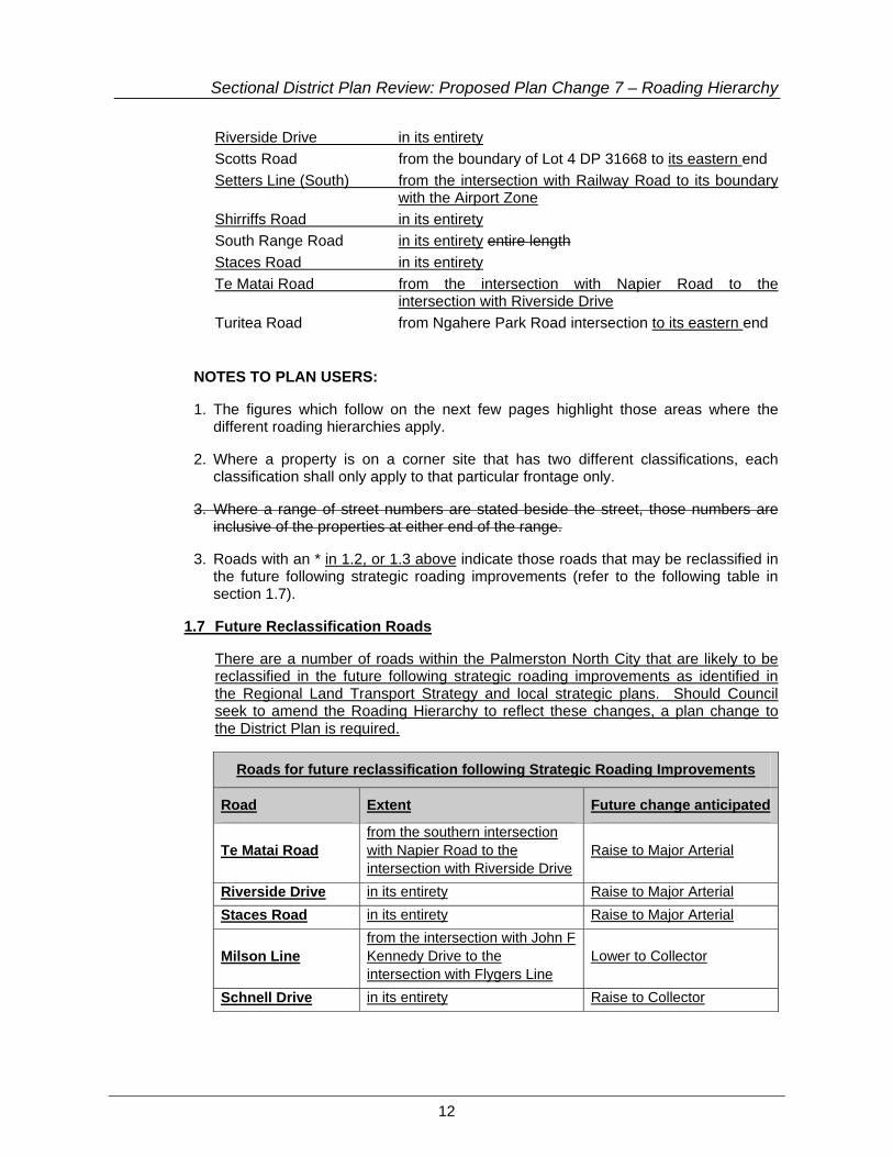
Riverside Drive in its entirety Scotts Road from the boundary of Lot 4 DP 31668 to its eastern end Setters Line (South) from the intersection with Railway Road to its boundary
with the Airport Zone Shirriffs Road in its entirety South Range Road in its entirety entire length Staces Road in its entirety Te Matai Road from the intersection with Napier Road to the
intersection with Riverside Drive Turitea Road from Ngahere Park Road intersection to its eastern end
NOTES TO PLAN USERS:
1. The figures which follow on the next few pages highlight those areas where the different roading hierarchies apply.
2. Where a property is on a corner site that has two different classifications, each classification shall only apply to that particular frontage only.
3. Where a range of street numbers are stated beside the street, those numbers are inclusive of the properties at either end of the range.
3. Roads with an * in 1.2, or 1.3 above indicate those roads that may be reclassified in the future following strategic roading improvements (refer to the following table in section 1.7).
1.7 Future Reclassification Roads
There are a number of roads within the Palmerston North City that are likely to be reclassified in the future following strategic roading improvements as identified in the Regional Land Transport Strategy and local strategic plans. Should Council seek to amend the Roading Hierarchy to reflect these changes, a plan change to the District Plan is required.
Roads for future reclassification following Strategic Roading Improvements
Road Extent Future change anticipated
Te Matai Road from the southern intersection with Napier Road to the intersection with Riverside Drive
Raise to Major Arterial
Riverside Drive in its entirety Raise to Major Arterial Staces Road in its entirety Raise to Major Arterial
Milson Line from the intersection with John F Kennedy Drive to the intersection with Flygers Line
Lower to Collector
Schnell Drive in its entirety Raise to Collector

Sectional District Plan Review: Proposed Plan Change 7 – Roading Hierarchy
13
The Regional Land Transport Strategy also includes a future link via a new bridge between Pioneer Highway and State Highway 57 as a future Major Arterial Route. The location of this future route is not yet determined. As such, there are no specific roads that can be identified at this stage.
13. Figure 20A.1 – Roading Hierarchy – Palmerston North (rural)
Amend Figure 20A.1 as shown overleaf.
14. Figure 20A.2 – Roading Hierarchy – Palmerston North (urban)
Amend Figure 20A.2 as shown overleaf.
15. Figure 20A.3 – Roading Hierarchy - Ashhurst
Amend Figure 20A.3 as shown overleaf.
16. Figure 20A.4 – Roading Hierarchy – PN Central Area
Amend Figure 20A.4 as shown overleaf. Note that this Figure has already been changed through Proposed Plan Change 1: Central Business Zones. A minor change to the legend is required to be consistent with the proposed Roading Hierarchy classifications.
17. Figure 20A.5 – Restricted Access Roads
Amend Figure 20A.5 as shown overleaf.
18. Figure 20A.6 – Future Re-classification Roads
Insert a new Figure 20A.6 as shown overleaf reflecting those roads that may change classification in the future as the Strategic Roading Network is constructed.

Sectional District Plan Review: Proposed Plan Change 7 – Roading Hierarchy
14
19. Appendix 20B – construction criteria for new roads and street description
Amend Appendix 20B as follows:
TYPE CRITERIA MIN RESERVE WIDTH*
MIN CARRIAGEWAY WIDTH*
MIN BERM WIDTH
TYPICAL DESCRIPTION
Urban and or Rural
>300 EDUC
22m 13m 2 x 4.5 m Major Arterial or Minor Arterial Principal
Urban
150 – 300 EDUC
20m 11 m 2 x 4.5 m Major Arterial or Minor Arterial Principal
Rural 18 m 9 m (2 x 3.5 m lanes) (2 x 1.0m shoulders)
2 x 4.5 m Major Arterial or Minor Arterial Principal
Urban
EDUC of 60 – 150
18 m 9 m 2 x 4.5 m Minor Arterial Principal or Collector
Rural 16 m 7 m (2 x 3 m lanes) (2 x 0.5m shoulders)
2 x 4.5 m Minor Arterial Principal or Collector
Urban EDUC of 12 - 60
17 m 8 m 2 x 4.5 m Local
Urban EDUC of 0 - 12
16 m 7 m 2 x 4.5 m Local
Rural, Rural Residential, Parklands
EDUC of 0 - 60
14 m 6.2 m (2 x 3 m lanes) (2 x 0.1m shoulders
2 x 3.9 m
Local
Industrial EPE of > 150
22 m 13 m 2 x 4.5 m Local
Industrial EPE of 0 – 150
17 m 11.5 m 1 x 4.5m and 1 x 1.0 m
Local
*Roads having either a longitudinal gradient steeper than 1:10 or having a horizontal alignment with any curve less than 100metres radius will be subject to specific design and will require approval of the Roading Manager
EDUC Estimated Dwelling Units in the Catchment
EPE Estimated Personnel Employed

Figure 20A.1ROADING HIERARCHY - PALMERSTON NORTH (RURAL)
Major Arterial RoadsMinor Arterial RoadsCollector RoadsSecondary Roading NetworkLocal RoadsTLA Boundary Line
Primary Roading Network
Secondary Roading Network
±
0 1 2 3 4 5Km
1:80,000

Figure 20A.2ROADING HIERARCHY - PALMERSTON NORTH (URBAN)
±
0 1 2 3Km
1:40,000
Major Arterial RoadsMinor Arterial RoadsCollector RoadsSecondary Roading NetworkLocal RoadsTLA Boundary Line
Primary Roading Network
Secondary Roading Network

Major Arterial RoadsMinor Arterial RoadsCollector RoadsSecondary Roading NetworkLocal RoadsTLA Boundary Line
Secondary Roading Network
Primary Roading Network±
0 0.5 1Km
1:19,000
Figure 20A.3ROADING HIERARCHY - ASHHURST

LONG
BURN
RON
GOTE
A RD
NORTH R ANGE RD
CAMP RD
SCOTTS R D
KAHUTERA WA RD GREENS R D
TUR ITE
A RD
STAC
ES R
D
SOUTH RANGE R D
FO REST HILL RD
SHIR
RIFF
S RD
TE M
ATAI
RD
Figure 20A.5
±
0 1 2 3 4 5Km
1:70,000
RESTRICTED ACCESS ROADS
Restricted Access RoadsTLA Boundary Line - (Existing)
RIVER
SIDE
DR
PAHIATUA AOK AUTER E RD
SETTERSLINE
Sectional District Plan Review: Proposed Plan Change 7 – Roading Hierarchy
15
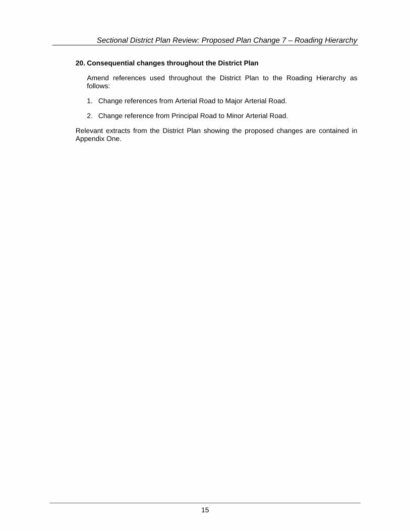
20. Consequential changes throughout the District Plan
Amend references used throughout the District Plan to the Roading Hierarchy as follows:
1. Change references from Arterial Road to Major Arterial Road.
2. Change reference from Principal Road to Minor Arterial Road.
Relevant extracts from the District Plan showing the proposed changes are contained in Appendix One.

Sectional District Plan Review: Proposed Plan Change 7 – Roading Hierarchy
16
Part II – Section 32 Report
1 Introduction
This report has been prepared in fulfilment of the requirements of Section 32 of the Resource Management Act 1991 (RMA) which requires local authorities to prepare a report summarising the evaluation of the alternatives, benefits and costs of the plan change, and giving reasons for that evaluation. Pursuant to Section 32(3) of the RMA, this evaluation details the appropriateness of the objectives in achieving the purpose of the RMA, and whether, having regard to their efficiency and effectiveness, the policies and rules proposed are the most appropriate for achieving the objectives.
2 Plan Change Objective
The objective of this Proposed Plan Change is to update Section 20 of the District Plan in light of strategic documents and land transport plans, including the Regional Land Transport Strategy. The changes will ensure that the Roading Hierarchy in Section 20 remains up to date; that the future reclassification of roads in the Roading Hierarchy are identified to plan users; and that Section 20 reflects the terminology used in the Regional Land Transport Strategy.
3 Reason for the Proposed Plan Change
3.1 Site description
Roads within the Palmerston North City boundary are all subject to a Roading Hierarchy classification.
Under Rule 24.3.1 all roads in the Palmerston North City Boundary are designated, and have the underlying zoning of the adjoining land.
The District Plan currently identifies roads within the City according to the following categories:
Primary Roads
(i) Arterial Roads
These are roads of strategic importance to the Region and the country and provide both for access between different parts of the City and for links with other towns and cities. Generally arterial roads have two to four lanes of traffic with a road reserve width of 22-30 m and often some carriageway separation or access control.
Arterial roads include State Highways 3 and 56 and John F Kennedy Drive.
(ii) Principal Roads
Principal roads are an essential element of the City’s roading network. They provide access between different land use activities and distribute traffic from the

Sectional District Plan Review: Proposed Plan Change 7 – Roading Hierarchy
17
arterial roads. These roads carry between 5,000 and 20,000 vehicles per day, are two lanes wide and have a road reserve width of 20 m.
Botanical Road and Fitzherbert Road East are examples of principal roads.
(iii) Collector Roads
These are roads which are significant locally and distribute traffic from principal roads. Collector roads provide access for sites and activities, and cater for through traffic. Typical traffic flows are between 3,000 and 10,000 vehicles per day. Collector roads are usually two lanes with road reserve width of 17 m to 20 m. These roads are also likely to be used by pedestrians.
Two examples of a collector road are Highbury Avenue and Linton Camp Road.
Secondary Roads
(iv) Local Roads
These roads’ primary function is to provide access, though they do collect and distribute traffic to other streets within a local area. Such roads typically carry up to 3,000 vehicles per day and their two lanes provide for on-street parking, property access and pedestrian needs. Road reserve widths vary from 16 m to 18 m.
Buick Crescent and Milverton Avenue are examples of local roads.
Other Roads
(v) Parking Streets3
Parking streets are streets where a significant function is providing parking, and which offer pedestrians safe and easy access to a range of civic, cultural, retail and business activities within the Central Area.
These parking streets include Ashley Street and King Street. Figure 20A.4 shows all Parking Streets in Palmerston North.
(vi) Pedestrian Streets
Like parking streets, Pedestrian streets are located in the centre of the City. They provide a safe and convenient network of links to carry pedestrians into the activities offered in the Central Area.
The Square, Broadway Avenue, Main Street, Coleman Place, Cuba Street, King Street, Fitzherbert Avenue, Church Street, Ashley Street and George Street are all both pedestrian streets. Figure 20A.4 shows all Pedestrian Streets in Palmerston North.
3 Sectional District Plan Review Proposed Plan Change 1: Central Business Zones has deleted
reference to Parking Streets (shown by shading above). This Plan Change endorses the changes identified by the PPC1 to the roading hierarchy classification.
Sectional District Plan Review: Proposed Plan Change 7 – Roading Hierarchy
18
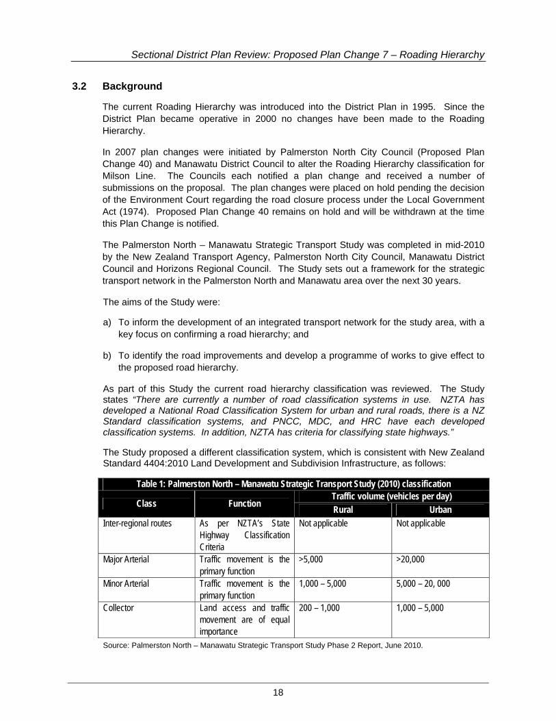
3.2 Background
The current Roading Hierarchy was introduced into the District Plan in 1995. Since the District Plan became operative in 2000 no changes have been made to the Roading Hierarchy.
In 2007 plan changes were initiated by Palmerston North City Council (Proposed Plan Change 40) and Manawatu District Council to alter the Roading Hierarchy classification for Milson Line. The Councils each notified a plan change and received a number of submissions on the proposal. The plan changes were placed on hold pending the decision of the Environment Court regarding the road closure process under the Local Government Act (1974). Proposed Plan Change 40 remains on hold and will be withdrawn at the time this Plan Change is notified.
The Palmerston North – Manawatu Strategic Transport Study was completed in mid-2010 by the New Zealand Transport Agency, Palmerston North City Council, Manawatu District Council and Horizons Regional Council. The Study sets out a framework for the strategic transport network in the Palmerston North and Manawatu area over the next 30 years.
The aims of the Study were:
a) To inform the development of an integrated transport network for the study area, with a key focus on confirming a road hierarchy; and
b) To identify the road improvements and develop a programme of works to give effect to the proposed road hierarchy.
As part of this Study the current road hierarchy classification was reviewed. The Study states “There are currently a number of road classification systems in use. NZTA has developed a National Road Classification System for urban and rural roads, there is a NZ Standard classification systems, and PNCC, MDC, and HRC have each developed classification systems. In addition, NZTA has criteria for classifying state highways.”
The Study proposed a different classification system, which is consistent with New Zealand Standard 4404:2010 Land Development and Subdivision Infrastructure, as follows:
Table 1: Palmerston North – Manawatu Strategic Transport Study (2010) classification
Class Function Traffic volume (vehicles per day) Rural Urban
Inter-regional routes As per NZTA’s State Highway Classification Criteria
Not applicable Not applicable
Major Arterial Traffic movement is the primary function
>5,000 >20,000
Minor Arterial Traffic movement is the primary function
1,000 – 5,000 5,000 – 20, 000
Collector Land access and traffic movement are of equal importance
200 – 1,000 1,000 – 5,000
Source: Palmerston North – Manawatu Strategic Transport Study Phase 2 Report, June 2010.

Sectional District Plan Review: Proposed Plan Change 7 – Roading Hierarchy
19
As a result of the Study the Regional Land Transport Strategy (RLTS) has, in Appendix 3, identified a Strategic Transport Network. The Strategic Transport Network is included in the Regional Land Transport Strategy and is shown below.
Figure 1: Regional Strategic Network as shown in the Regional Land Transport Strategy

Sectional District Plan Review: Proposed Plan Change 7 – Roading Hierarchy
20
Figure 2: The Regional Strategic Network around Palmerston North (as shown in the Regional Land Transport Strategy)
As a result of the Palmerston North – Manawatu Strategic Transport Study, and the changes made in the Regional Land Transport Strategy, Council has determined that it is appropriate to update the Roading Hierarchy classification in the District Plan.
It is noted that where the boundary between Manawatu District Council and Palmerston North City Council falls on a road there is formal agreement for which Road Controlling Authority has responsibility for maintaining those roads. The changes to the Roading Hierarchy proposed in this Plan Change do not alter the existing agreement.
Sectional District Plan Review: Proposed Plan Change 7 – Roading Hierarchy
21
4 Proposed Plan Change
Proposed Plan Change 7 involves updating the Roading Hierarchy in Appendix 20A, Section 20 Transportation of the District Plan. The main reasons for the various changes are the result of the Palmerston North – Manawatu Strategic Transport Study and to acknowledge where the function of roads has changed since the Roading Hierarchy was originally included in the District Plan. For instance, some roads have become Major Arterials from Minor Arterials (previously referred to as Principal Roads) or from Local Roads to Collector Roads.
The proposed changes are considered by Council to be necessary. These changes have been developed based on the range of matters identified in the explanation to Section 20.3.5 in the District Plan. Those matters include:
• Existing traffic service functions;
• Existing land uses;
• Existing characteristics, e.g. road standard, width and capacity;
• Current traffic volumes;
• Future land use strategies; and
• Anticipated traffic increases.
The changes to the Roading Hierarchy are identified in Table 2, including the need for the change or where the change originated. Other consequential changes to the Plan are also required (refer Part 1, section 2 of this report).
Table 2: Changes to the Roading Hierarchy
Road From To Proposed Change
Need for Change
Railway Road Tremaine Avenue Boundary Raise to Major Arterial
Palmerston North – Manawatu Strategic Transport Study
Airport Drive Railway Road Milson Line Lower to Minor Arterial
Palmerston North – Manawatu Strategic Transport Study, to be reviewed in a future urban study
John F Kennedy Drive
Milson Line Rangitikei Street Lower to Minor Arterial
Palmerston North – Manawatu Strategic Transport Study, to be reviewed in a future urban study
Haydon Street Keith Street Vogel Street Raise to Collector Connects Collector to Minor Arterial
Parnell Heights Drive
Roberts Line James Line Raise to Collector Connects Collector to Major Arterial

Sectional District Plan Review: Proposed Plan Change 7 – Roading Hierarchy
22
Table 2: Changes to the Roading Hierarchy Road From To Proposed
Change Need for Change
Brooklyn Heights Drive/Schnell Drive/Fernlea Ave
James Line Roberts Line Raise to Collector Connects Collector to Major Arterial
Rosalie Terrace James Line Roberts Line Raise to Collector Connects Collector to Major Arterial
Mihaere Drive Roberts Line Keith Street Raise to Minor Arterial
Connects Major and Minor Arterials
Keith Street Mihaere Drive Napier Road Raise to Minor Arterial
Connects Major and Minor Arterials
Roberts Line Napier Road McLeavey Drive Raise to Major Arterial
Palmerston North – Manawatu Strategic Transport Study
McLeavey Drive Roberts Line Kelvin Grove Road
Raise to Major Arterial
Palmerston North – Manawatu Strategic Transport Study
Roberts Line Kelvin Grove Road
Richardsons Line Raise to Collector Palmerston North – Manawatu Strategic Transport Study
Kelvin Grove Road McLeavey Drive Tremaine Avenue Raise to Major Arterial
Palmerston North – Manawatu Strategic Transport Study
Tremaine Avenue Kelvin Grove Road
No 1 Line Raise to Major Arterial
Palmerston North – Manawatu Strategic Transport Study
No 1 Line Tremaine Avenue Longburn Rongotea Road
Raise to Major Arterial
Palmerston North – Manawatu Strategic Transport Study
Longburn Rongotea Road
No 1 Line Pioneer Highway Raise to Major Arterial
Palmerston North – Manawatu Strategic Transport Study
Pioneer Highway Longburn Rongotea Road
Pitt Street Raise to Major Arterial
Palmerston North – Manawatu Strategic Transport Study
Rugby Street/ Ferguson Street
Maxwells Line Botanical Road Raise to Collector Connects to Minor Arterial
Slacks Road Maxwells Line Pitama Road Raise to Collector Connects Collector roads
Monrad Street Pembroke Street Pioneer Highway Raise to Collector Connects Collector Road to Major Arterial
Cuba Street Pitt Street Pascal Street Raise to Collector Connects Major Arterial to Collector road
Pascal Street Cuba Street Featherston Street
Raise to Collector Connects to Minor Arterial

Sectional District Plan Review: Proposed Plan Change 7 – Roading Hierarchy
23
Table 2: Changes to the Roading Hierarchy Road From To Proposed
Change Need for Change
Ward Street Grey Street Featherston Street
Raise to Collector Connects Collector to Minor Arterial
Roy Street Featherston Street
Tremaine Avenue Raise to Collector Connects Minor Arterials
Park Road Fitzherbert Avenue
Victoria Avenue Raise to Collector Connects Collector to Major Arterial
Albert Street Main Street Featherston Street
Raise to Collector Connects Major Arterial to Minor Arterial
Ferguson Street Albert Street Ruahine Street Raise to Collector Connects Collector to Minor Arterial
Manawatu Street Ruahine Street Albert Street Raise to Collector Connects Collector Roads
Summerhill Drive Tennent Drive Old West Road Raise to Major Arterial
Palmerston North – Manawatu Strategic Transport Study
Cashmere Drive Aokautere Drive Ruapehu Drive Raise to Collector Connects Major Arterial to Collector
Johnstone Drive Aokautere Drive Pacific Drive Raise to Collector Connects Minor Arterial to Major Arterial
Pahiatua Aokautere Road
Aokautere Drive (SH57)
TDC Boundary Raise to Major Arterial
Palmerston North – Manawatu Strategic Transport Study
Stoney Creek Road Napier Road MDC Boundary Raise to Minor Arterial
Palmerston North – Manawatu Strategic Transport Study
The Regional Land Transport Strategy refers to inter-regional routes as part of the roading hierarchy classification. These routes within Palmerston North City correspond to the Major Arterial Roads. On this basis reference to inter-regional routes are not included in the Roading Hierarchy.
The Council also wants to highlight those roads where a future change in hierarchy may occur. The future reclassification of roads within the hierarchy will be identified to inform the community that changes to road status may change in the future. The changes outlined in Table 3 will largely occur following road upgrades as part of the Strategic Roading Network improvements identified in the Regional Land Transport Strategy. In the future, should Council seek to amend the following road classifications then a plan change to the District Plan is required. Note that these future reclassification roads are shown on new Figure 20A.6 which will be included in the Appendix Maps in Section 20 of the District Plan.

Sectional District Plan Review: Proposed Plan Change 7 – Roading Hierarchy
24
Table 3: Future reclassification changes to the Roading Hierarchy Road Extent Proposed Change Reason
Te Matai Road from the southern intersection with Napier Road to the intersection with Riverside Drive
Raise to Major Arterial Palmerston North – Manawatu
Strategic Transport Study
Riverside Drive in its entirety Raise to Major Arterial Staces Road in its entirety Raise to Major Arterial Milson Line from the intersection with John F
Kennedy Drive to the intersection with Flygers Line
Lower to Collector
Schnell Drive in its entirety Raise to Collector Currently Private Road. To be added once road status changes.
The Regional Land Transport Strategy also includes a future link via a new bridge between Pioneer Highway and State Highway 57 as a future Major Arterial Route. The location of this future route is not yet determined. As such, there are no specific roads that can be identified at this stage.
4.1 Supporting Evidence
The Council considered a number of reports in preparing this Plan Change. These included:
• Palmerston North – Manawatu Strategic Transport Study – Phase 1 Report (2010)
• Palmerston North – Manawatu Strategic Transport Study – Phase 2 Report (2010)
• Regional Land Transport Strategy 2010 – 2040 (2010)
• Proposed One Plan, as amended by decisions on submissions (2010)
• NZS 4404:2010 Land Development and Subdivision Infrastructure (2010).
5 Statutory requirements
Before a plan change is publicly notified, the Council must undertake the following duties under Section 32 of the RMA:
“32 Consideration of alternatives, benefits, and costs –
(1) In achieving the purpose of this Act, before a … change … is publicly notified … an evaluation must be carried out by– … (c) the local authority, for a policy statement or plan …
(2) A further evaluation must also be made by– (a) a local authority before making a decision under clause 10 or clause 29(4) of
the Schedule 1; …

Sectional District Plan Review: Proposed Plan Change 7 – Roading Hierarchy
25
(3) An evaluation must examine– (a) the extent to which each objective is the most appropriate way to achieve
the purpose of this Act; and (b) whether, having regard to their efficiency and effectiveness, the policies,
rules, or other methods are the most appropriate for achieving the objectives. …
(4) For the purposes of the examinations referred to in subsections (3) and (3A), an evaluation must take into account– (a) the benefits and costs of policies, rules, or other methods; (b) the risk of acting or not acting if there is uncertain or insufficient information
about the subject matter of the policies, rules, or other methods. (5) The person required to carry out an evaluation under subsection (1) must prepare a
report summarising the evaluation and giving reasons for that evaluation. (6) The report must be available for public inspection at the same time as the document
to which the report relates to is publicly notified or the regulation is made.”
The purpose of the RMA is the baseline against which these statutory steps are to be carried out. Section 5 of the RMA sets out the purpose of that Act. The following sections are relevant:
“5. Purpose –
(1) The purpose of this Act is to promote the sustainable management of nature and physical resources.
(2) In this Act, “sustainable management” means managing the use, development, and protection of natural and physical resources in a way, or at a rate, which enables people and communities to provide for their social, economic, and cultural wellbeing and for their health and safety while- (a) Sustaining the potential of natural and physical resources (excluding
minerals) to meet the reasonably foreseeable needs of future generations; and
(b) Safeguarding the life-supporting capacity of air, water, soil, and ecosystems; and
(c) Avoiding, remedying, or mitigating any adverse effects of activities on the environment”
Other sections of relevance in Part 2 of the Act are as follows:
“7. Other Matters –
In achieving the purpose of this Act, all persons exercising functions and powers under it, in relation to managing the use, development, and protection of natural and physical resources, shall have particular regard to – …
(b) the efficient use and development of natural and physical resources:
(ba) the efficiency of the end use of energy:
(c) The maintenance and enhancement of amenity values: …
(f) Maintenance and enhancement of the quality of the environment: …

Sectional District Plan Review: Proposed Plan Change 7 – Roading Hierarchy
26
(i) The effects of climate change;”
The relevant functions of the Council in this instance are set out in sections 31 (a), (b) and (d) as follows:
“31. Functions of territorial authorities under this Act –
Every territorial authority shall have the following functions for the purpose of giving effect to this Act in its district:
(a) The establishment, implementation, and review of objectives, policies, and methods to achieve integrated management of the effects of the use, development, or protection of land and associated natural and physical resources of the district:
(b) The control of any actual or potential effects of the use, development, or protection of land, including for the purpose of
(i) the avoidance or mitigation of natural hazards; and
(ii) the prevention or mitigation of any adverse effects of the storage, use, disposal, or transportation of hazardous substances; and
(iia) the prevention or mitigation of any adverse effects of the development, subdivision, or use of contaminated land:
(iii) the maintenance of indigenous biological diversity: …
(d) The control of the emission of noise and the mitigation of the effects of noise: …
(f) Any other functions specified in this Act.”
To achieve the purpose of the RMA in accordance with the stated functions, any proposed District Plan provisions must be the most appropriate method of providing for any changes to the Roading Hierarchy whilst avoiding, mitigating or remedying the effects of any use and/or development on the environment. The proposed changes ensure the Roading Hierarchy correctly reflects the function each road has within the City.
The new classification is consistent with the provisions of NZS4404:2010 and the Regional Land Transport Strategy. By adopting the new classification for the Roading Hierarchy Council is achieving integrated management between the relevant strategic documents. The proposed changes to the classification terms does not change the access and sight distance provisions in the District Plan. The proposed changes to roads within the hierarchy mean that access and sight distance provisions will change for those roads only. This is appropriate given the function each road has in moving transportation around the City.
Section 74 of the RMA states that when changing a district plan the Council shall have regard to a number of factors including any management plans and strategies prepared under other Acts. In this instance, the provisions of the Regional Land Transport Strategy are particularly relevant to this Proposed Plan Change. In addition, the Proposed One Plan amended by decisions on submissions, states in Policy 3-1 that councils must recognise the road and rail networks as mapped in the Regional Land Transport Strategy as being

Sectional District Plan Review: Proposed Plan Change 7 – Roading Hierarchy
27
physical resources of regional or national importance. This Proposed Plan Change is giving effect to this policy and the provisions of the Regional Land Transport Strategy.
The proposed changes also include reference to those roads that may be re-classified in the future, once the Strategic Roading Network (including the Rural Ring Road around Palmerston North City) has been constructed. It would be inappropriate to alter the classifications now of those roads. The reclassification should occur when the function of those roads change as a result of constructing the Strategic Roading Network.
Overall the proposed changes to the Roading Hierarchy and consequential references in the District Plan are considered to be an efficient and effective means to manage the roading network.
6 Chronology
The following outlines the key milestones in preparing the Proposed Plan Change to date:
March 2011 Opus International Consultants (Opus) were commissioned to prepare Sectional District Plan Review Proposed Plan Change 7 – Roading Hierarchy.
May 2011 Draft Proposed Plan Change released for Clause 3 consultation.
25 May 2011 Feedback on the Draft Proposed Plan Change closed.
June / July 2011 Draft Plan Change amended in light of Clause 3 consultation and the Proposed Plan Change and Section 32 report prepared.
September 2011 Planning and Policy Committee approves plan change for notification under the Resource Management Act 1991.
6.1 Indicative timeline of Plan Change process
An indicative timetable of the plan change process is illustrated below:
Council publicly notifies Proposed Plan Change (November 2011)
Submissions close (January 2012)
Summarise Submissions (February 2012)
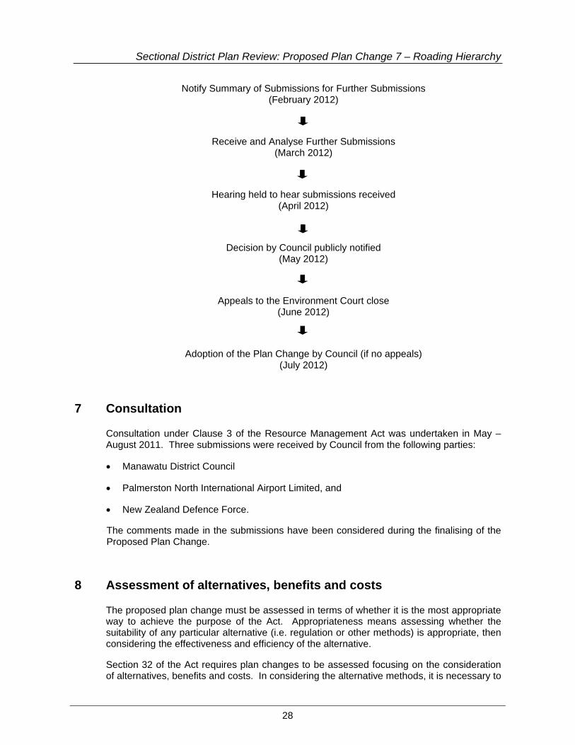
Sectional District Plan Review: Proposed Plan Change 7 – Roading Hierarchy
28
Notify Summary of Submissions for Further Submissions (February 2012)
Receive and Analyse Further Submissions (March 2012)
Hearing held to hear submissions received (April 2012)
Decision by Council publicly notified (May 2012)
Appeals to the Environment Court close (June 2012)
Adoption of the Plan Change by Council (if no appeals) (July 2012)
7 Consultation
Consultation under Clause 3 of the Resource Management Act was undertaken in May – August 2011. Three submissions were received by Council from the following parties:
• Manawatu District Council
• Palmerston North International Airport Limited, and
• New Zealand Defence Force.
The comments made in the submissions have been considered during the finalising of the Proposed Plan Change.
8 Assessment of alternatives, benefits and costs
The proposed plan change must be assessed in terms of whether it is the most appropriate way to achieve the purpose of the Act. Appropriateness means assessing whether the suitability of any particular alternative (i.e. regulation or other methods) is appropriate, then considering the effectiveness and efficiency of the alternative.
Section 32 of the Act requires plan changes to be assessed focusing on the consideration of alternatives, benefits and costs. In considering the alternative methods, it is necessary to

Sectional District Plan Review: Proposed Plan Change 7 – Roading Hierarchy
29
consider different planning methods to achieve the purpose of the Act, including retaining the status quo, non-regulatory methods and the proposed plan change.
The following alternatives were considered and have been assessed:
• Alternative 1 – Retain the current Roading Hierarchy (status quo).
• Alternative 2 – Apply revised road classifications.
8.1 Alternative 1 – Retain the current Roading Hierarchy (status quo)
This alternative involves no change to the District Plan. The classification of roads in the City would remain as arterial roads, principal roads, collector roads, local roads and pedestrian streets.
Maintain Status Quo
Retain the Roading Hierarchy classification of Arterial Roads, Principal Roads, Collector Roads, Local Roads and Pedestrian Streets. No change to the access provisions would result.
Benefits Costs
• No change to the District Plan is required; therefore no costs are incurred by Council (and ratepayers).
• This alternative is not consistent with the recommendations in the Palmerston North – Manawatu Strategy Transport Study which recommended changes to the Road Hierarchy classification.
• This alternative is not consistent with Regional Land Transport Strategy and the classification adopted in that Strategy following the recommendations of the Palmerston North – Manawatu Strategy Transport Study.
• The changes in road classification within the hierarchy are necessary to reflect the current function of those roads. To retain the current provisions would not reflect the actual use of these roads.
• The existing road classification is not consistent with the provisions of NZ4404:2010 Land Development and Subdivision Infrastructure.
Efficiency and Effectiveness:
The cost of this alternative is that the road hierarchy in the District Plan does not reflect the function of the road. This means that the correct access provisions are not applied. Retaining the status quo means that the Roading Hierarchy is also inconsistent with NZS 4404:2010 and the Regional Land Transport Strategy. This alternative is not effective from a consistency point of view with the Regional Land Transport Strategy. As a party to the Palmerston North – Manawatu Strategy Transport Study it is not appropriate for Council to ignore

Sectional District Plan Review: Proposed Plan Change 7 – Roading Hierarchy
30
the recommendations of that Study to reclassify the Roading Hierarchy categories. The access provisions for roads are defined by the Roading Hierarchy. Not amending some road classifications to reflect the current functions of roads could result in adverse environmental effects.
Risk of acting or not acting if there is uncertain or insufficient information:
Not acting will see inconsistencies between the District Plan and the Regional Land Transport Strategy. Council has a duty under Section 35 of the Act to gather information and take appropriate action as new information comes to hand. Given the recommendations of the Palmerston North – Manawatu Strategy Transport Study it is considered that there is sufficient information on which to act.
Appropriateness:
This alternative is not considered to be effective in managing transportation issues for the City. The status quo does not recognise the results of the Palmerston North – Manawatu Strategy Transport Study nor the recent changes to the Regional Land Transport Strategy. The changes of roads within the road hierarchy must be recognised to ensure appropriate access provisions are applied to those roads with particular functions.
8.2 Alternative 2 – Apply revised road classifications
This alternative includes the amendments discussed in Part 1, section 2 of this Report.
Proposed Plan Change
The Proposed Plan Change amends the road classifications and the status of some roads with the City boundary. The figures showing the location of the various classifications are also amended. No changes are proposed to the existing access and sight line provisions.
Some road additions are proposed to the list of Restricted Access Roads. This is required to ensure that future subdivision activity adjacent to roads that have been identified as part of the future rural ring road and will require upgrading are appropriately managed to avoid large numbers of access ways onto future major arterial routes. Future road classifications are also highlighted. These roads may change classification in the future following strategic roading improvements. Setters Line (south) has also been added as a Restricted Access Road due to the current condition of the road.
Consequential changes are required throughout the District Plan provisions to reflect the change in classification terms.
Benefits Costs
• Minimum distances for access are retained.
• The proposed changes are consistent with the provisions of the Regional Land Transport Strategy, the findings of the Palmerston North – Manawatu Strategic Transport Study and NZS4404:2010 Land Development and Subdivision Infrastructure.
• Amendments to roads within the hierarchy reflect the actual function of those roads within the City. This is necessary as the function of some roads
• There are costs associated with preparing the Proposed Plan Change. There are also costs associated with completing the Resource Management Act First Schedule notification and submission process.
• The inclusion of additional Restricted Access Roads could limit development where numerous separate accesses are sought to the road. There is a need to protect these future strategic routes. Inclusion of roads into the Restricted Access Roads list will not stop development; it merely

Sectional District Plan Review: Proposed Plan Change 7 – Roading Hierarchy
31
has changed since the District Plan was prepared in the 1990s.
• The additions to the list of Restricted Access Roads future proofs the future rural ring road that was confirmed in the Palmerston North – Manawatu Strategic Transport Study.
• The level of service each road in the City provides is more clearly identified through the proposed changes.
requires alternative access proposals.
Efficiency and effectiveness:
On balance, the benefits of this alternative outweigh the costs associated with it. Having regard to Section 32(3) of the RMA, the existing Roading Hierarchy is not consistent with the relevant strategic documents. Without the changes there would be no strategic alignment between the statutory plans of the Regional Council and the Palmerston North City Council. In addition, the current Roading Hierarchy does not fully reflect the true function of many of the roads in the City.
Identifying those roads where Council anticipates a future change in classification reflects the Strategic Roading Network. It is inappropriate to change the road classifications at this time. Future changes will require a plan change to the District Plan and will occur when the function of the road changes following construction of the Strategic Roading Network. The Sectional District Plan Review will enable future changes to be undertaken more quickly rather than waiting for a formal 10 year review.
Risk of acting or not acting if there is uncertain or insufficient information:
There is sufficient information for Council to act. Council has information, in the form of the Palmerston North – Manawatu Strategic Transport Study, the NZS4404:2010 and the Regional Land Transport Strategy, that clearly signal that changes to the current Roading Hierarchy are required. Council has a duty to ensure that the District Plan aligns with the relevant strategic documents, including the Proposed One Plan.
Appropriateness:
Council has a responsibility under Section 35(2)(b) of the Resource Management Act to monitor the efficiency and effectiveness of policies, rules, or other methods in its policy statement or its plan; and…take appropriate action (having regard to the methods available to it under this Act) where this is shown to be necessary. The current Roading Hierarchy does not adequately reflect the function of many roads within the city, nor does it use the most recent best practice approach to road classification (NZS4404:2010).
It would be inappropriate for Council to not proceed with the Plan Change as it has a duty to update the District Plan as far practicable. Therefore this Plan Change is consistent with Section 35(2) of the Resource Management Act.
9 Assessment of Proposed Objectives, Policies and Rules
9.1 Assessment of Objectives
This Plan Change is not proposing any new objectives; instead it is relying on the existing objectives in the District Plan, which are considered to already be the most appropriate way to achieve the purpose of the Act.

Sectional District Plan Review: Proposed Plan Change 7 – Roading Hierarchy
32
9.2 Evaluation of Policies and Methods
Under Section 32(3)(b) of the Act the Council must examine whether, having regard to their efficiency and effectiveness, the policies and rules are the most appropriate for achieving the objectives of the Plan Change. As noted in section 9.1 above no changes are proposed to the Objectives in the Plan.
The Proposed Plan Change proposes one minor consequential change to Policy 1.2 to ensure the correct Roading Hierarchy terms are used. This is considered to be a minor consequential change resulting from changes proposed in the Roading Hierarchy classification. Other consequential cross referencing changes are also required. These merely ensure the correct terms are used and do not change the intent of the existing District Plan provisions.
This Proposed Plan Change is relying on the existing policies in the District Plan which, being operative, are considered to be the most appropriate means to implement the Objectives.
The existing rules relating to access and sight distances are not changed as a result of this Proposed Plan Change. Minor cross referencing changes are required throughout the Plan to reflect the new classification in the Plan. The existing provisions are considered to be an entirely appropriate means to manage effects and meet the objectives of this plan change.
9.3 Appropriateness of methods to achieve the objectives
The amendment to the Roading Hierarchy in the District Plan largely relates to the provisions in Appendix 20 of the District Plan.
In terms of whether the methods in the District Plan are the most appropriate for achieving the objectives of the District Plan, it is noted that the Roading Hierarchy is already in Section 20 of the District Plan. This plan change essentially updates the classification, consistent with the recommendations of the Palmerston North – Manawatu Strategic Transport Study and the recently revised Regional Land Transport Strategy. Changes to roads within the Hierarchy reflect the change in function they have and ensure that appropriate access restrictions are in place.
The Plan Change relies on the existing rules in the District Plan to manage the effects of access and sight distances. These existing rules are considered to be both effective and efficient and the most appropriate method to achieve the objectives of the District Plan. Note that minor changes are required to policies and rules throughout the plan to ensure consistent road hierarchy classification terms are used. These changes do not alter the intent of the existing Plan provisions.
The proposed changes are considered necessary to achieve the objectives of the Proposed Plan Change. Overall the changes to the Roading Hierarchy in the Proposed Plan Change are the most appropriate way to achieve the objectives of the Plan Change and will assist Council to carry out its functions in order to achieve the purpose of the Resource Management Act.

Sectional District Plan Review: Proposed Plan Change 7 – Roading Hierarchy
33
10 Conclusion
This Proposed Plan Change seeks to amend the Roading Hierarchy to ensure consistency between key strategic documents, particularly the Regional Land Transport Strategy. The new road classifications are consistent with best practice, particularly the recent changes in the NZS4404:2010.
The addition of some roads into the Restricted Access Roads list has been identified as part of the future rural ring road around Palmerston North. Their inclusion in the Roading Hierarchy will ensure these roads are managed for future function as Major Arterial Roads.
Overall the existing objectives, policies and rules have been considered the most appropriate way to achieve the purpose of the Act. The Council has sufficient information in which to act, by way of making changes to the Roading Hierarchy.
This evaluation has been undertaken in accordance with Section 32 of the Act. The provisions have been informed by key strategic documents. The evaluation demonstrates that the proposed plan change meets the requirements of Section 32 of the Act.

Sectional District Plan Review: Proposed Plan Change 7 – Roading Hierarchy
34
Appendix One: District Plan Extracts - consequential changes required in the District Plan (other than in Section 20)
1. Section 6 General, R 6.1.5.1 Permitted Activities for Signs (d) Area
(i) Any advertising signs (both permanent and temporary) shall comply with the following maximum total area for signs in the relevant zone:
Zone Maximum Total Area (m2)
Location with Zone Permanent Temporary Residential (sites on Major Arterial, Minor Arterial, Arterial, Principal, or Collector Roads)
2.5 m2 2.5 m2
Residential (sites on Local Roads)
0.6 m2 0.6 m2
Inner Business, Outer Business, Local Business, Fringe Business, Industrial, Airport (only sites which front onto or adjoin a Residential Zoned site)
10.0 m2 visible from any front on or adjoining residentially zoned site
10.0 m2 visible from any front on or adjoining residentially zoned site
Institutional Zone (only sites which front onto or adjoin a Residential Zoned site)
10.0 m2 visible from any front on or adjoining residentially zoned site
10.0 m2 visible from any front on or adjoining residentially zoned site
Recreation, Conservation and Amenity, and Flood Protection (all sites)
(i) For sites under 5.0ha in size - 4.0 m2 plus an additional 1.0 m2 for each building on the site (ii) For sites over 5.0ha in size – 6.0 m2 plus an additional 2.0 m2 for each additional 10.0ha plus an additional 1.0 m2 for each building on the site
(i) For sites under 5.0ha in size – 4.0 m2 plus an additional 1.0 m2 for each building on the site (ii) For sites over 5.0ha in size – 6.0 m2 plus an additional 2.0 m2 for each additional 10.0ha plus an additional 1.0 m2 for each building on the site (iii) For Specified Sporting Facilities – 30m2
Rural and Race Training (all sites)
10.0 m2 10.0 m2
North East Industrial Zone (all sites)
10.0 m2 10.0 m2
Caccia Birch Zone 4.0 m2 4.0 m2
Water Recreation Zone N/A N/A

Sectional District Plan Review: Proposed Plan Change 7 – Roading Hierarchy
35
2. Section 7 Subdivision, Policy 1.5 1.5 To enable the subdivision of rural land where the following matters have been
recognised and provided for:
1. The land proposed to be subdivided should be suitable for subdivision with:
(a) the efficient servicing and development of the land;
(b) earthquake fault lines;
(c) liability to erosion, subsidence, slippage or inundation from any source;
(d) the stability of the land and its suitability to provide a foundation for the erection of buildings (if necessary, and the reconstruction of the land for that purpose);
(e) any other natural hazard;
(f) safety, health and amenity.
2. Adequate provision should be made for water supply, waste disposal, drainage, the disposal of sewage, and the supply of electricity.
3. The subdivision does not lead to any significant obstruction to, or other interference with, the free movement of traffic on roads in the City, and in particular on State Highways, Major Arterial and Minor Arterial Roads and Principal Roads.
3. Section 10 Residential Zone, R 10.8.1.2 Accommodation Motels (excluding those prohibited by R 10.8.6.1) …
Performance Conditions (a) Location
Accommodation motels may only be located on properties having frontage and the main entryway from a street listed as a Major Arterial or Minor Arterial an arterial or principal road in Appendix 20A in the Transportation Section.
4. Section 10 Residential Zone, R 10.8.1.3 Education Facilities and Early
Childhood Facilities (excluding those prohibited by R 10.8.6.1). …
Performance Conditions (a) Location
An education facility must provide access to and from a Minor Arterial principal or collector road, listed as such in Appendix 20A in the Transportation Section.
5. Section 10 Residential Zone, R 10.8.4.2 Motel Conference Centres on properties
having frontage onto, and the main accessway from, a Major Arterial or Minor Arterial an Arterial Road or Principal Road as listed in Appendix 20A of the Transportation Section (excluding those prohibited by R 10.8.6.1).

Sectional District Plan Review: Proposed Plan Change 7 – Roading Hierarchy
36
6. Section 11 Business Zone, R 11.7.2.1 explanation Access to and from an Major Arterial Road, such as Main Street, requires careful attention because the primary function of the road is to provide for the movement of large traffic volumes. The design, location and number of access points to an Major Arterial Road has a direct relationship to the safety and efficiency of the road.
7. Section 11 Business Zone, R 11.8.5.1 explanation Access to and from a Minor Arterial Principal Road, such as Summerhill Drive, requires careful attention because the primary function of the road is to provide for the movement of large traffic volumes. The design, location and number of access points to a Minor Arterial Principal Road has a direct relationship to the safety and efficiency of the road.
8. Section 11 Business Zone, R 11.8.5.2 Controlled Activities on Lot 1 DP 87509 (formerly part of Pt Sec 211, corner of Aokautere Drive and Ruapehu Drive) and Lots 3, 4 and 5 DP 87509 on Ruapehu Drive. Any activity, including the construction, alteration of, or addition to a building or structure on Lot 1 DP 87509 (formally part of Pt Sec 211, corner of Aokautere Drive and Ruapehu Drive) and Lots 3, 4 and 5 DP 87509 on Ruapehu Drive which is not a Non-Complying Activity, and which complies with the following Performance Conditions is a Controlled Activity in respect of:
• Integration with the adjacent Conservation and Amenity Zone;
• Landscaping;
• Design and Appearance of Buildings;
• Access to and from a State Highway, Major Arterial Road or Minor Arterial Principal Road as listed in Appendix 20A of the Transportation Section.
…..
(d) Access to and from a State Highway, Major Arterial or Minor Arterial Principal Road (as identified in Appendix 20A of the Transportation Section) (i) To avoid, remedy or mitigate any adverse effects of traffic gaining access
to and from a state highway, Major Arterial Road or Minor Arterial Road arterial road or principal road (as identified in Appendix 20A of the Transportation Section) on the safe and efficient operation of the roading network.
(ii) To avoid the proliferation of accesses to a state highway, Major Arterial Road or Minor Arterial Road arterial road, or principal road (as identified in Appendix 20A of the Transportation Section) where the posted speed limit is greater than 50 km/h.
(iii) To avoid the design of accesses from a state highway, Major Arterial Road or Minor Arterial Road arterial road or principal road (as identified in Appendix 20A of the Transportation Section) where the movements to and from a site create conflict with opposing traffic.
….

Sectional District Plan Review: Proposed Plan Change 7 – Roading Hierarchy
37
Explanation
Access to and from a state highway, Major Arterial Road or Minor Arterial Road arterial road or principal road (as identified in Appendix 20A of the Transportation Section) needs consideration, especially since these roads have a primary function to move large volumes of traffic. The design and number of accesses from these roads can generate adverse effects in terms of road safety where traffic entering or exiting a site has to cross the path of large volumes of opposing traffic moving at high speeds. Where a Major Arterial Road or a Minor Arterial Road an arterial road or principal road is also a state highway, the requirements of Transit New Zealand, as road controlling authority for any state highway, also must be taken into account.
9. Section 11 Business Zone, 11.9.1 – Objective 1 explanation The areas zoned Fringe Business are located on and in the vicinity of Rangitikei Street and in a number of cases have a residential interface, either by adjoining a residentially zoned property and/or facing a residentially zoned property(ies) separated by a road. All Fringe Business zoned areas adjoin Primary Roads (i.e. Major Arterial, Minor Arterial or Collector Roads arterial or principal roads), which provides them with exposure as well as easy access onto the roading network.
10. Section 11 Business Zone, R 11.9.5.1 Matters of Discretion In determining whether to grant consent (and the conditions if any that should be imposed) Council reserves its discretion to an assessment of the extent to which the application meets the objectives and policies of the Fringe Business Zone and the following assessment criteria:
(i) The extent to which the development provides active frontages including entrances and openings facing the edge of all Major Arterial Roads.
11. Section 12 Industrial Zone, Objective 4 explanation The historical pattern of industrial development within the city has resulted in a significant number of industries locating adjacent to either a Major Arterial or Minor Arterial an arterial or principal roadway. These roads are also used by a large volume of residential, rural and recreational users. Given the community’s desire to enhance the amenity value of urban areas it is important that industry makes a positive contribution to visual amenity within industrial areas, particularly where these areas abut a major roadway.
12. Section 12 Industrial Zone, R 12.6.2 Construction, Alteration of, and Addition to Buildings and Structures …
(iii) Road Setback (a) On sites fronting onto any Major Arterial or Minor Arterial Road principal
road, any building or structure, excluding signs, shall be set back no less than 8 metres from the road frontage.

Sectional District Plan Review: Proposed Plan Change 7 – Roading Hierarchy
38
13 Section 12A North East Industrial Zone, Objective 5 explanation The North East Industrial Zone is surrounded on three sides by rural land within and outside the City boundary. It is separated from these areas by roads, which provide some extent of buffering. It is important to ensure that industrial activities within the Zone do not have significant adverse effects on the quality and amenity of the nearby rural area and residents within the rural area, including visual or noise effects. As far as practicable, industrial traffic should be directed away from rural roads that are classified as local roads (see Section 20), and onto Minor Arterial and Major Arterial Roads. principal and arterial roads.
14. Section 19 Institutional Zone, R 19.6.2 The Construction of, or Addition to, Buildings
…
(e) Road Setback (i) On sites fronting onto any Major Arterial or Minor Arterial principal Road
(as identified in Appendix 20A of the Transportation Section), any building or structure shall be set back at least 8 metres from the road frontage.
…
Explanation Given that many of the City’s institutionally zoned sites front onto Major Arterial roads, which are important City entranceways, the Council considers that there is a need to ensure that adequate separation exists between road frontages and buildings in order to enhance the visual amenity associated with these approaches, and to provide adequate space within which planting can occur.
15. Section 19 Institutional Zone, R 19.7.1 Site Access explanation As many of these institutions also adjoin Major Arterial or Minor Arterial principal roadways and quieter local residential streets, any new access and egress points will be assessed to ensure that they are located and formed with safety in mind.
16. Section 23 Utilities, R 23.7.1 Permitted Activities …
Performance Conditions (a) Height
(iii) In the case of masts, these must comply with:
(a) a setback of not less than 5 metres from any boundary common with a Residential Zone or Recreation Zone site; and
a setback of not less than 8 metres from a boundary fronting a Major an Arterial or Minor Arterial Principal Road as listed in Appendix 20A of the Transportation Section; and

Sectional District Plan Review: Proposed Plan Change 7 – Roading Hierarchy
39
a setback of not less than 3 metres from a boundary fronting any road other than an a Major Arterial or Minor Arterial Principal Road as listed in Appendix 20A of the Transportation Section;


