IN THE MATTER OF: * FAIRLAND DEVELOPMENT, LLC AND * FAIRLAND DEVELOPMENT II, LLC * * Applicants * Development Plan Amendment Application * No. DPA 09-1 Alfred Blumberg * Wes Guckert * Marc A. Mezzanotte * Bernard J. Rafferty * * For the Applicant * *
Barbara A. Sears, Esquire * Yum Yu Cheng, Esquire *
I. SUMMARY............................................................................................................................................3 II. STATEMENT OF THE CASE ..............................................................................................................4 III. FINDINGS OF FACT...........................................................................................................................5
A. Subject Property ..............................................................................................................................5
B. Surrounding Area.............................................................................................................................8
C. Zoning History................................................................................................................................10
D. Proposed Development .................................................................................................................10
E. Development Plan ..........................................................................................................................13
F. Master Plan ....................................................................................................................................25
G. Environmental................................................................................................................................28
H. Public Facilities ..............................................................................................................................34
1. Transportation ............................................................................................................................34 2. Schools.......................................................................................................................................37 3. Other Public Facilities.................................................................................................................39
I. Other Public Interest Issues ............................................................................................................41
J. Community Support........................................................................................................................43
K. Opposition......................................................................................................................................43
IV. SUMMARY OF HEARING................................................................................................................44
A. Applicant’s Case in Chief...............................................................................................................44 C. Opposition .....................................................................................................................................53 D. People’s Counsel ..........................................................................................................................54
V. ZONING ISSUES...............................................................................................................................54
A. The Development Plan ..................................................................................................................55
1. Purposes of the Zone ..........................................................................................57
2. Standards and Regulations of the Zone .................................................................................62
B. Public Interest ................................................................................................................................67
VI. CONCLUSIONS ...............................................................................................................................68 VII. RECOMMENDATION......................................................................................................................69
DPA 09-1 Page 3
I. SUMMARY
Site Size and Location: The combined property that is the subject of this application (the “subject property”) measures a total of approximately 314 acres. It sits along the border between Montgomery County and Prince George’s County, just south of MD 198 and east and north of Greencastle Road.
Ownership and Current Use: A large area in the southern part of the subject site is owned by the
MNCPPC as part of Fairland Regional Park, including the Gunpowder Golf Course and forested areas. The MNCPPC also owns a smaller forested area in the middle of the site. The remainder of the site is owned by the present Applicant, a private developer, and is undeveloped. Part of the Applicant’s property was once the site of mining and landfill activities, and the Applicant has already begun stabilization and reclamation work.
On May 28, 2009, the Montgomery County Planning Board approved
the purchase of approximately 53 acres of the privately-owned part of the subject site under the County’s Legacy Open Space program. The proposed development plan amendment provides that if the MNCPPC acquires this land, the land will be used as open space or parkland, and the number of homes proposed for the residential project will decrease. This land acquisition must be approved by the County Council.
Zoning: The subject site was rezoned to the PD-2 Zone in 2004, via local map
amendments G-813 and G-814. Two applications were necessary because the privately-owned part of the site is bisected by PEPCO property used for power lines.
Previously Approved The 2004 Development Plan anticipated closing the Gunpowder Golf Development: Course, carrying out a series of private/public land exchanges, and
redeveloping the entire subject site with a residential community of up to 396 homes situated around a new 18-hole golf course. The golf course and residential community were planned to extend over the county line, requiring various approvals from Prince George’s County. Those approvals were not obtained, and therefore the Development Plan could not be implemented.
Proposed Development Plan The Applicant requests approval for an amendment to the 2004 Amendment: Development Plan that would allow the privately owned land to be
developed with up to 365 dwelling units (mostly single-family detached homes) and the publicly owned land to be retained as parkland or open space. As part of the proposed development plan amendment, the Applicant has committed to dedicating 11 acres of land to the County as a school site, as well as 23 acres as park land. This application proposes no changes to the Gunpowder Golf Course or any other part of Fairland Recreational Park.
If the MNCPPC acquires the 53 acres of land referred to above, that
land will be designated as parkland, and the maximum number of homes to be built on the Applicant’s remaining land will be reduced to 260.
DPA 09-1 Page 4
Recommendations: The Hearing Examiner, the Planning Board and Technical Staff recommend approval, finding that the proposed Development Plan Amendment would comply with the purposes of the zone, would be substantially consistent with the applicable master plan and would be compatible with existing and proposed uses in the surrounding area.
Neighborhood Response: The application enjoys support from the Fairland Master Plan Citizens
Advisory Committee. Opposition was expressed at the hearing from the Greencastle Lakes Community Association, which argued that the subject site should not be developed because it would increase traffic congestion, eliminate scarce parkland and open space, harm the environment, increase school crowding and overburden police and fire services that are already inadequate.
II. STATEMENT OF THE CASE
The present application, filed on July 16, 2008 by Fairland Development, LLC and Fairland
Development II, LLC (together, the “Applicant”)1, requests approval for an amendment to the
development plan that was approved for the subject property when the property was reclassified to the
PD-2 Zone (Planned Development) in 2004. The subject property consists of a total of 313.94 acres of
land along the border between Montgomery County and Prince George’s County, south of MD 198 and
east and north of Greencastle Road in the 5th Election District. The entire subject property was
rezoned to the PD-2 Zone in 2004, in conjunction with a development plan approved by the District
Council that provided for the construction of a new golf course community with a maximum of 396
single-family homes (including 50 single-family attached Moderately Priced Dwelling Units, or MPDUs).
The present application requests approval of a development plan amendment that would separate the
publicly and privately owned land by creating three amended development plans: G-813 Part I and G-
814, G-813 Part II and G-813 Part III. G-813 Part I and G-814 would, together, provide for the
construction of a new, single-family residential community with up to 365 single-family dwellings,
including up to 46 MPDUs, as well as the dedication of an 11-acre school site (with grading, forest
1 The two entities comprising the Applicant in this case are successors in interest to the private entity named as an applicant on the 2003 rezoning application for the subject properties. The original applicants were Artery Ryland Fairland, LLC and the MNCPPC. In approximately 2005, two entities owned by Artery bought out Ryland’s interest in the property. The names of those Artery entities were subsequently changed to Fairland Development, LLC and Fairland Development II, LLC. See Tr. May 22, 2009 at 10-12.
DPA 09-1 Page 5
conservation and stormwater management provided by the Applicant) and 23 acres of park land. G-
813 Part II and G-813 Part III would provide for the continued use of the publicly-owned parts of the
subject site as parkland.
The present application was initially reviewed by Technical Staff of the MNCPPC who, in a
report dated April 27, 2009, recommended approval. See Ex. 42. Staff provided additional comments,
in response to questions from the Hearing Examiner, in emails dated May 20, 26 and 29, 2009. See
Exs. 62, 69 and 70. The entire Montgomery County Planning Board (“Planning Board”) considered the
application on May 7, 2009 and voted unanimously to recommend approval. A public hearing was
scheduled for May 15, 2009, but was postponed until May 22, 2009 at the request of the Greencastle
Lakes Community Association. The hearing was conducted on May 22, 2009, at which time testimony
and evidence were presented in support of and in opposition to the applications. The hearing was re-
convened briefly on June 2 and 11, 2009 to accept into the record revisions to the Applicant’s proposal
and a brief description of the possible acquisition of part of the privately-owned portion of the site by the
MNCPPC. As required under Section 59-D-1.74(d) of the Zoning Ordinance, the record closed at the
close of the final hearing session.
III. FINDINGS OF FACT
For the convenience of the reader, the findings of fact are grouped by subject matter. Where
there are conflicts in the evidence, these conflicts are resolved under the preponderance of the
evidence test.
A. Subject Property
The subject property stretches along the county line from MD 198 in the north to Greencastle
Road in the south, with an irregular shape and varying width. The property has approximately 1,370
feet of frontage on MD 198, widens to approximately 2,500 feet in width adjacent to the Saddle Creek
neighborhood to the west, then narrows down to a single point less than an inch wide at its southern
end, about 400 feet north of Greencastle Road. The property is bisected near its northern end by
DPA 09-1 Page 6
PEPCO transmission lines. The subject property’s shape and relationship to surrounding land uses are
shown on the map below.
Vicinity Map, Excerpted from Hearing Examiner’s Report in G-813/G-814
MD 198 G-814 property
PEPCO lines
Outline of G-813 property
Greencastle Road Old Gunpowder
Road
County Line
MD 29
DPA 09-1 Page 7
The portion of the subject property northeast of the PEPCO transmission lines, which was the
subject of LMA Case No. G-814, contains 18 acres of land and is roughly triangular, bounded by MD
198 to the north, the county line to the east/southeast and the PEPCO power lines to the west. This
tract is owned by the Applicant and has approximately 1,270 feet of frontage on MD 198 and 1,875 feet
of frontage along the PEPCO property. It is undeveloped, with woods on the majority of the tract and
wetlands on roughly the southern two-thirds. To the east, in Prince George’s County, are industrial
uses and storage lots extending all the way to Old Gunpowder Road.
The larger portion of the subject property, southwest of the PEPCO transmission lines, was the
subject of Case No. G-813 and contains the bulk of the property, 295.94 acres of land. It has
approximately 100 feet of frontage on MD 198 to the north, and is bounded by the PEPCO power lines
and the county line to the east. A stream described as the McKnew Tributary to the Little Paint Branch
runs through the G-813 property, parallel to the county line.
The southern part of the G-813 property is in public ownership as part of Fairland Recreational
Park. The portion of Fairland Recreational Park within the subject property consists of the Gunpowder
Golf Course and a wooded area that has been called the “southern spike” because it is roughly
triangular and ends in a sharp point. The Gunpowder Golf Course extends across the county line and
is accessed via Old Gunpowder Road, in Prince George’s County. The southern spike is a forested
area with recreational trails. A stream known as the Silverwood Tributary to the Little Paint Branch runs
through the golf course and converges with the McKnew tributary. The combined streams then flow
south, through the southern spike, to join the Little Paint Branch main stem. Areas of Fairland
Recreational Park to the west, outside the subject property, contain additional forested area plus active
recreation areas (ball fields, tennis courts and basketball courts) along Greencastle Road. To the east,
the southern spike abuts active recreation areas of Fairland Regional Park in Prince George’s County.
The development plan amendment proposed in this application shows no changes to any of the publicly
owned land on the subject property, which would remain as parkland.
The Applicant owns nearly all of the G-813 property located north/east of Gunpowder Golf
Course (approximately 165 acres), except for one small area owned by the MNCPPC. Portions of this
DPA 09-1 Page 8
privately owned land have been mined for sand and gravel, resulting in an assortment of cleared areas.
An area in about the middle of the privately owned property was used as an illegal landfill (the “stump
dump”) for many years. The Applicant purchased this land in 2006, after the MNCPPC indicated that
the County would not be purchasing it due to the cost of the required clean-up. The Applicant has
since entered into a consent agreement with the Maryland Department of the Environment (“MDE”) to
reclaim part of the land for development (to be the site of a swimming pool and community center) and
cover the remainder with a cap and clean fill, for use as open space. The site has been fenced off to
prevent further illegal dumping, and all surface trash and debris has been cleared.
The remainder of the G-813 property consists primarily of open space, with a large area of high
priority forest surrounding the McKnew Tributary as it enters the subject property. The northern part of
the privately owned land abuts residential subdivisions, McKnew Local Park and forest to the west. To
the east, it abuts a cluster of industrial uses in Prince George’s County, as well as undeveloped Prince
George’s County land that is planned as the site of approximately 148 homes connected to the
residential community proposed in the present application, if approved by Prince George’s County.
B. Surrounding Area
The surrounding area must be identified in a floating zone case so that compatibility can be
evaluated properly. The “surrounding area” is defined less rigidly in connection with a floating zone
application than in evaluating a Euclidean zone application. In general, the definition of the surrounding
area takes into account those areas that would be most directly affected by the proposed development.
In the present case, Technical Staff defined the surrounding area as the area referred to in the 1997
Approved and Adopted Fairland Master Plan as the “Oakfair/Saddle Creek” community, which extends
from MD 198 on the north to and including Fairland Recreational Park to the south, and from the
County line on the east to the Silverwood Tributary on the west. See Master Plan at 33; Vicinity Map
on page 6 above. The Hearing Examiner accepts the surrounding area designation proposed by
Technical Staff. The subject property constitutes about half of the land area within the surrounding
DPA 09-1 Page 9
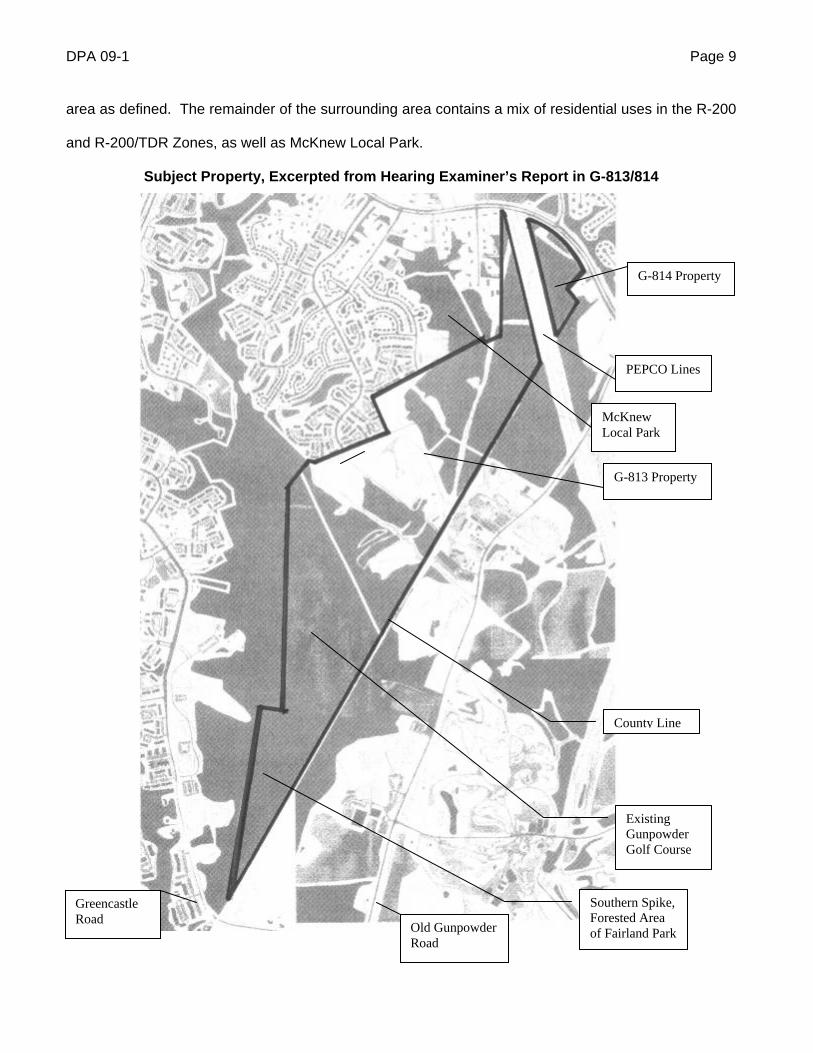
area as defined. The remainder of the surrounding area contains a mix of residential uses in the R-200
and R-200/TDR Zones, as well as McKnew Local Park.
Subject Property, Excerpted from Hearing Examiner’s Report in G-813/814
G-814 Property
G-813 Property
PEPCO Lines
Greencastle Road
Old Gunpowder Road
County Line
Southern Spike, Forested Area of Fairland Park
Existing Gunpowder Golf Course
McKnew Local Park
DPA 09-1 Page 10
C. Zoning History
The subject property was classified under the R-A Zone (now RE-2, two-acre single-family) in
the 1958 Countywide Comprehensive Zoning. The property was reclassified under the R-200 Zone in
parts, via sectional map amendments enacted in 1982, 1987 and 1997. Parts of the property were the
subject of three unsuccessful local map amendment applications in 1964, 1989 and 1991. The entire
subject property was reclassified under the PD-2 Zone in 2004, via LMA Cases G-813 and G-814.
D. Proposed Development
The Applicant seeks to develop the subject property with up to 365 single-family homes,
consisting of approximately 319 detached homes and 46 MPDUs in the form of duplexes and/or
townhouses. The Applicant has made a binding commitment to dedicate by deed approximately 11
acres of land as a school site (with grading, stormwater management and forest conservation provided
by the Applicant) and approximately 23 acres of land as parkland. Required road right-of-way
dedications would occupy another 19 acres. The Amended Land Use Plan (the main component of the
proposed amended Development Plans), also shows residential amenities including a clubhouse, a
swimming pool, open space areas and trails linking homes within the development to one another, to
adjoining residential neighborhoods and to the trail system in adjacent Fairland Recreational Park.
As shown on the illustrative plan on the next page, the homes would fall into two
neighborhoods, one located at the north end of the site, including the G-814 property and the portion of
the G-813 property north of McKnew Local Park, and the other at the south end of the site, abutting
Gunpowder Golf Course and the Saddle Creek residential neighborhood to the west. If the proposed
land sale to the MNCPPC is consummated, the northern neighborhood will be eliminated and that land
will become parkland. This would reduce the maximum number of homes to 248, including up to 31
MPDUs. The school site and parkland dedications would be unchanged, per the written binding
elements of the Amended Land Use Plan. The illustrative plan and the Amended Land Use Plan
provide an approximate layout for the various uses, but the exact limits of each use area and of
individual home lots are left to be determined during site plan review.
DPA 09-1 Page 11
Illustrative C
on
cept, E
x. 40(i)
DPA 09-1 Page 12
The northern neighborhood would have its sole vehicular access from Route 198, across from
Riding Stable Road. It would be connected to the southern neighborhood via a pedestrian trail only. It
would abut a small enclave of existing single-family detached homes centered on Birmingham Drive,
but no vehicular connection is planned between the two. The southern neighborhood would have two
points of vehicular access in Montgomery County, from Saddle Creek Drive and Cedar Tree Drive. The
extension of Cedar Tree Drive would connect to Saddle Creek Drive, which would then flow through the
development. If the residential development that the Applicant proposes on the Prince George’s
County side of the line is approved, the Applicant hopes to continue Saddle Creek Drive into Prince
George’s County, connecting to Old Gunpowder Road. If that development is not approved, Saddle
Creek Drive is planned to end in a cul de sac at the county line, as shown on the illustrative plan and
the Amended Land Use Plan.
MPDUs are shown on the illustrative plan in several clusters. The written binding elements on
the Amended Land Use Plan specify that MPDUs will consist of townhouse and duplex units, and that
no more than 16 MPDUs will be provided in any one location. This language was included at the
request of Technical Staff, in keeping with MNCPPC policy that encourages the dispersal of MPDUs
throughout a subdivision, as well as a recommendation to that effect in the Master Plan. The
Department of Housing and Community Affairs (“DHCA”), which administers the MPDU program,
objected to this language. DHCA requested that the Amended Land Use Plan state only that the
location of MPDUs would be determined at site plan. See Staff Report Attachment 17. The Planning
Board and Technical Staff recommended the language shown on the plan over DHCA’s objection.
DHCA did not indicate the reason for its objection, either in writing or in its oral presentation before the
Planning Board, nor did DHCA participate in the Hearing Examiner’s hearing. Absent any reasoning
to support DHCA’s position, the Hearing Examiner sees no reason to require a change from the
language suggested by the Planning Board and its Staff, which makes it clear that MPDUs cannot be
grouped in a single location, but leaves flexibility to determine at site plan where to locate them and
how many should be grouped together.
DPA 09-1 Page 13
E. Development Plan
Pursuant to Code § 59-D-1.11, development under the PD Zone is permitted only in accordance
with a development plan that is approved by the District Council when the property is reclassified to the
PD Zone. This development plan must contain several elements, including a land use plan showing
site access, proposed buildings and structures, a preliminary classification of dwelling units by type and
number of bedrooms, parking areas, land to be dedicated to public use, and land intended for common
or quasi-public use but not intended to be in public ownership. Code §59-D-1.3. The Development
Plan, and the Land Use Plan that constitutes one of its primary elements, are binding on the Applicant
except where particular elements are identified as illustrative or conceptual. The Development Plan is
subject to site plan review by the Planning Board, and minor changes may be made at that time. The
principal specifications on the Development Plan – those that the District Council considers in
evaluating compatibility and compliance with the zone, for example – may not be changed without
further application to the Council to amend the Development Plan.
The present application has complied with the requirements for a Development Plan through a
single set of documents covering the entire subject property, including both the G-813 property and the
G-814 property. The principal component of the three Development Plans proposed here is the
Amended Land Use Plan, Exhibit 82(a). Additional components of the Development Plan include the
NRI/FSD (Exhibits 34 (s) – (v)) , vicinity maps (e.g. Exs. 6, 13, 25, 34(l) and 34(m)) and a phasing plan
(Ex. 82(b)).
The Applicant proposes, with the consent of the MNCPPC, to divide the subject property into
three amended Development Plans: (1) G-813 Part I and G-814; (2) G-813 Part II and (3) G-813 Part
III. G-813 Part I and G-814 would, together, provide for the construction of the proposed residential
community, including the school and parkland dedications. G-813 Part II and G-813 Part III would
provide for the continued use of the publicly-owned parts of the subject site as parkland. The aerial
photograph on the next page is overlaid with an outline identifying the geographic area covered by each
of the proposed amended Development Plans.
DPA 09-1 Page 14
Aerial Photograph Identifying Three Amended Development Plans: G-813 Part I and G-814, G-813 Part II G-813 Part III
DPA 09-1 Page 15
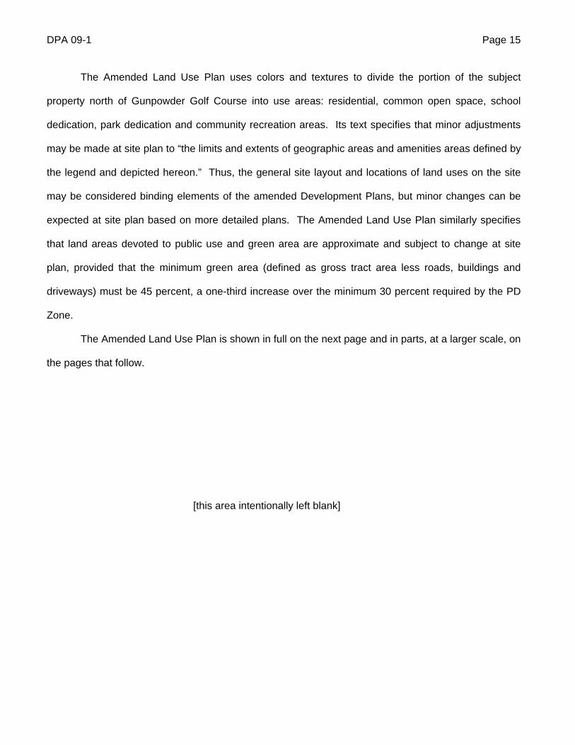
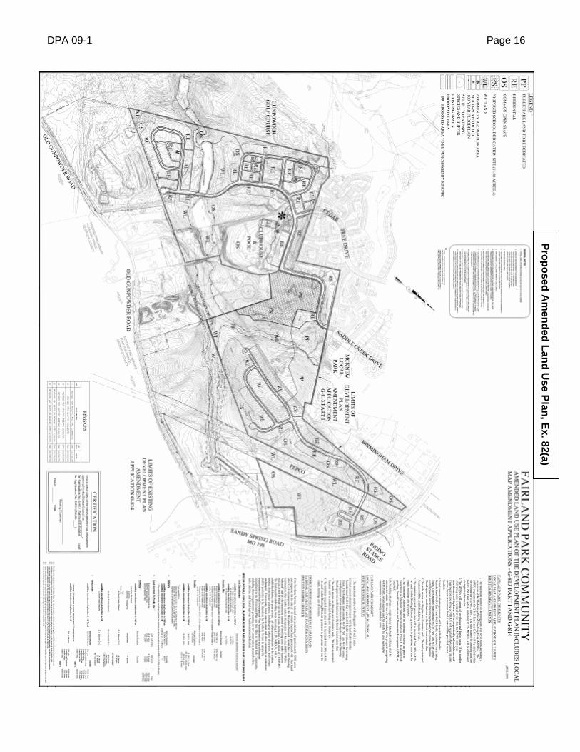
The Amended Land Use Plan uses colors and textures to divide the portion of the subject
property north of Gunpowder Golf Course into use areas: residential, common open space, school
dedication, park dedication and community recreation areas. Its text specifies that minor adjustments
may be made at site plan to “the limits and extents of geographic areas and amenities areas defined by
the legend and depicted hereon.” Thus, the general site layout and locations of land uses on the site
may be considered binding elements of the amended Development Plans, but minor changes can be
expected at site plan based on more detailed plans. The Amended Land Use Plan similarly specifies
that land areas devoted to public use and green area are approximate and subject to change at site
plan, provided that the minimum green area (defined as gross tract area less roads, buildings and
driveways) must be 45 percent, a one-third increase over the minimum 30 percent required by the PD
Zone.
The Amended Land Use Plan is shown in full on the next page and in parts, at a larger scale, on
the pages that follow.
[this area intentionally left blank]
DPA 09-1 Page 16
Pro
po
sed A
men
ded
Lan
d U
se Plan
, Ex. 82(a)
DPA 09-1 Page 17
Pro
po
sed A
men
ded
Lan
d U
se Plan
, Ex. 82(a), G
raph
ics On
ly
DPA 09-1 Page 18
Amended Land Use Plan Legend, from Ex. 82(a)
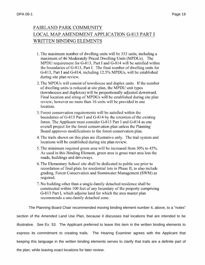
The Amended Land Use Plan contains three sets of written binding elements: one for G-813
Part I, one for G-814 and one addressing the possible sale of part of the subject property to the
MNCPPC. These binding elements are reproduced on following two pages, followed by the site data
table and general notes, which are illustrative elements of the plan.
[this area intentionally left blank]
DPA 09-1 Page 19
The Planning Board Chair recommended moving binding element number 4, above, to a “notes”
section of the Amended Land Use Plan, because it discusses trail locations that are intended to be
illustrative. See Ex. 53. The Applicant preferred to leave this item in the written binding elements to
express its commitment to creating trails. The Hearing Examiner agrees with the Applicant that
keeping this language in the written binding elements serves to clarify that trails are a definite part of
the plan, while leaving exact locations for later review.
DPA 09-1 Page 20
DPA 09-1 Page 21
DPA 09-1 Page 22
SIT
E D
AT
A T
AB
LE
CO
NT
INU
ED
DPA 09-1 Page 23
The proposed residential development would be built in three phases, demarcated on the map
on the next page. The school site is to be prepared and dedicated before the final plat is recorded in
Phase II. Only the graphics from the phasing plan are shown on the next page. Its text repeats the
written binding elements from the Amended Land Use Plan and states that if the potential property sale
to the MNCPPC takes place, those 53 acres will not be part of the phasing plan, but the park dedication
will remain in Phase III.
DPA 09-1 Page 24
Ph
asing P
lan G
raph
ics, from E
x. 82(b)
DPA 09-1 Page 25
F. Master Plan
The subject property falls within the area covered by the 1997 Approved and Adopted Fairland
Master Plan (the “Master Plan”), which divided the planning area into geographically defined
communities. The subject property corresponds very closely to Area 2 of the Oakfair/Saddle Creek
Community defined in the Master Plan, which was described, in relevant part, as follows:
Much of this area was built in the 1980s and encompasses about 1200 homes. . . . There are 800 townhouses and over 400 detached homes. The average density is six units to the acre. . . . Problems in the area include the lack of pedestrian connections from this neighborhood to the Fairland Recreational Park . . . Three public streets stub at the 200-acre tract of vacant land [the subject property] and there are concerns regarding the extension of these roads and the ability of the road system to accommodate additional units. . . . Area 2, is located between the residential development and the County line. Prior to the 1980s much of this acreage was used for sand and gravel excavation. There are forested areas, steep slopes and wetlands associated with the upper reaches of the Little Paint Branch. A series of ponds remain from earlier uses. Area 2 has the potential for adding detached units to the housing mix; expanding or reconfiguring the Gunpowder Golf Course, as proposed by one of the land owners; improving the road network including a possible extension of roads to Old Gunpowder Road in Prince George’s County; and hiker/biker access to the Fairland Recreational Park. The Planning Staff for the Montgomery County Public Schools has recommended that a school site be included in Area 2 for two reasons: the number of households that could be served (approximately 1,500) and the potential for children to walk to school. A school would provide a centrally located community focal point. Master Plan at 47.
The Master Plan recommended the PD Zone for Area 2, as described below:
Encourage use of the Planned Development (PD) zone to achieve the appropriate mix and size of units, an improved golf course design located outside the stream valley, and protection of other environmental features such as steep slopes and wooded areas. The PD will permit a greater level of scrutiny throughout the development process and will promote compatibility between the golf course community and the existing community that will share a street network and elementary school. Encourage a public/private partnership between Montgomery and Prince George’s County MNCPPC Parks Departments and the property owners to develop a golf course community. This would entail upgrading and expanding the existing public golf course and developing a residential community around the links. Master Plan at 47.
DPA 09-1 Page 26
The Master Plan listed several elements to be evaluated at the time of a zoning request for the
PD Zone (Master Plan at 48):
A density cap of 510 units overall, with 396 units in Montgomery County and an appropriate mix of housing types including single-family detached homes and attached units;
MDPUs to be distributed throughout the development;
Extension of the existing road network (see . . . page 93) ;
Areas of no disturbance or environmental impact (see page 119);
Non-vehicular access to Fairland Recreational Park;
Connect road(s) to Old Gunpowder Road in Prince George’s County, if
desirable;
Common open space for residents of the new community; and
A 12-15 acre site for a public elementary school.
The transportation section of the plan specified that Cedar Tree Drive should be extended to
Old Gunpowder Road to provide access for the new community and the golf course, and an alternative
access point for existing neighborhoods that are currently served only by MD 198. Master Plan at 94.
The Master Plan’s parkland recommendations describe the portion of the subject property
roughly between the PEPCO lines and Fairland Recreational Park as follows (Master Plan at 119):
The stream valley between McKnew Local Park and Fairland Recreational Park . . . contains a very diverse and unusual plant community. Although much of the area has been disturbed by quarrying, the remaining vegetation and the potential for re-vegetation make this stream valley worthy of protection as parkland.
The Planning Board and Technical Staff found that the proposed reclassification and
development of the subject property would be consistent with the goals and objectives of the Master
Plan. See Staff Report Attachment 12; Ex. 53. Technical Staff noted that the proposed plan would
provide a total of 365 units, with MPDUs dispersed throughout the development, the dedication of an
elementary school site, road connections and extensions, trail connections and paths that provide
access to Fairland Recreational Park for residents of the new development and nearby existing homes,
open space, a community center with pool and clubhouse, and a significant preservation of
DPA 09-1 Page 27
environmentally sensitive areas. See Staff Report at circle 16. Staff found that the proposal to build
predominantly single-family detached units is consistent with the Master Plan’s emphasis on creating
more single-family detached houses in this part of the County. See id.
The Applicant’s land planner, Alfred Blumberg, also opined that the proposed development
would substantially comply with the Master Plan, meeting its goals as well as can be done after the
failure of the original plan. In particular, Mr. Blumberg observed that one of the Master Plan’s important
goals for the Fairland area was providing more housing options, including increasing the number of
single-family detached homes. See Ex. 51(b) at 8. He concluded that the plan recommended zoning
categories like the PD Zone to balance the overall mix of units in the community. See id.
The Applicant’s traffic planner, Wes Guckert, opined that the proposed development would
satisfy the Master Plan’s transportation-related recommendations by extending Cedar Tree Drive to Old
Gunpowder Road, connecting Cedar Tree Drive to Saddle Creek Drive and providing a network of trails
and sidewalks. See Tr. June 22. at 142-43.
The Applicant’s forestry expert, John Markovich, testified that the proposed development plan
amendment would be consistent with the following Master Plan recommendations regarding
environmental issues (see Tr. May 22 at 189-91):
(1) Locate stormwater management facilities and sediment control measures outside the
stream valley buffers where feasible; the proposed plan would have only slight incursions into stream
valley buffers associated with sewer and stormwater management, which are almost impossible to
avoid while moving water downslope.
(2) Preserve existing forest within the stream valley buffers as much as possible, which the
proposed plan would do.
(3) Designate expanded non-wooded stream valley buffers in high-priority forest areas for
forest plantings; there are areas like this on site that could be planted at some point, but the proposed
plan does not provide for any planting because the plan already exceeds forest conservation
requirements through forest retention. Mr. Markovich stated that this was approved when the Planning
Board approved the preliminary forest conservation plan.
DPA 09-1 Page 28
G. Environmental
Under Chapter 22A of the Montgomery County Code, the proposed development is subject to a
forest conservation threshold of 20 percent of the site, or 36.13 acres. See Ex. 51(d), p. 4. It is also
subject to an afforestation requirement, related to the proposed clearing of 73.82 acres of forest above
the forest conservation threshold, equal to 15 percent of the site, or 18.46 acres. See id. The
submitted preliminary forest conservation plan satisfies these requirements by preserving 57.78 acres
of forest on site, approximately 9.5 percent more than the legal minimum. See id., Ex. 77, Staff Report
at circle 25-26.
The Staff Report and the attached memorandum from MNCPPC Environmental Planning Staff
recommend approval of the present application. Environmental Planning Staff observed that the
various approvals given to the previous plan (the 2004 Development Plan, site plan and preliminary
plan) recognized that achieving all the major Master Plan objectives, including the land-intensive
improved golf course, would result in significant loss of valuable natural resources, principally high-
priority forest and buffer areas. They noted that the current plan would remove 74 acres of high-priority
forest, 25 acres less than the 99 acres that the original plan would have removed. See Staff Report at
circle 23-24.
Environmental Planning Staff highlighted two Master Plan objectives related to the natural
environment, as described below.
Protect the unique and high quality resources of the Silverwood Tributary and the undisturbed
portions of the McKnew Tributary by encouraging cluster development of low to medium density
residential uses away from environmentally sensitive areas, creating forested open spaces near the
streams that are larger than the regulatory stream buffers. See id. at circle 24. Staff related the high
quality of these areas to the large expanse of contiguous forest (over 400 acres), as well significant
areas of diverse geologic and soil conditions and resulting unique vegetation. Staff described the
preservation of resources in this area and keeping them accessible to the public as “a countywide
importance.” Id.
DPA 09-1 Page 29
Staff noted that there are 133.4 acres of forest on the subject site, all designated as high-priority
and identified for protection in the Master Plan, with a goal to “use zoning options to the greatest extent
consistent with other Master Plan objectives to achieve the maximum contiguous high-priority forest.”
Staff Report at circle 25. Staff acknowledged that the forest conservation regulations emphasize
retaining forest to avoid any need for planting, and that the plan proposed here would preserve
approximately 2.4 acres more than the regulations require, thus there is no planting requirement. Staff
also noted that the proposed retention of approximately 57 acres of forest would exceed the
conservation threshold by about 20 acres. See id. at circle 25-26.
Staff emphasized that in addition to meeting the statutory numerical requirements, the
configuration of the forest proposed for retention provides larger areas of contiguous forest, because it
adjoins forest both on McKnew Local Park and on the 23-acre parkland dedication site. See id. at circle
26. Thus, Staff concluded that “the amount and configuration of retained forest shown on the
preliminary forest conservation plan meets all the priorities of the forest conservation law, including
saving large areas of contiguous forests, and the objective of the master plan to protect the very
diverse and unusual plan community.” Id.
An open question remains with regard to forest retention on the proposed school site.
Approximately 1.7 acres in the southernmost portion of the school site is shown as forest retention, but
it is possible that MCPS will find it necessary to clear some or all of this area. If that clearing occurs,
the Applicant will still meet forest retention requirements, based on the full subject site. If that clearing
occurs and the potential land sale to the MNCPPC also occurs, the Applicant might need to satisfy a
small part of its forest retention requirement through an easement over some of the land purchased by
the MNCPPC. The Applicant has reserved the right to do so in its negotiations with the MNCPPC, as
reflected on the Amended Land Use Plan and in a memorandum to the Applicant from Bill Gries,
MNCPPC Land Acquisition Specialist. See Exs. 82(a), 71.
Environmental Planning Staff did not address the possible acquisition of part of the subject site
by the MNCPPC, which was announced after the Staff Report was issued. The memorandum from Mr.
Gries indicates that the MNCPPC’s interest in acquiring part of the subject site stems from a desire to
DPA 09-1 Page 30
protect important natural resource areas including old growth upland forest, unique biodiversity and
diverse geologic and soil conditions. See Ex. 71. He notes that protecting these resources is
considered important to the water quality in the Little Paint Branch and consistent with the Master Plan.
See id. These goals are very much aligned with the goals discussed by Environmental Planning Staff,
suggesting that Staff would consider the proposed plan even better from an environmental standpoint
with MNCPPC’s potential acquisition of the land east of McKnew Local Park.
Carrying out restoration activities in the degraded portion of the lower McKnew tributary on the
subject site by including in any development both standard environmental measures, stormwater retrofit
and/or stream enhancement measures to help correct existing problems. See id. Staff noted that the
Applicant has taken responsibility for the stabilization of the degraded areas under its control, to
prevent further degradation. Staff argued that restoration should also include reforestation of portions
of the stabilized area that are within environmental buffer areas, “to be considered at later phases of
review.” Testimony from the Applicant’s representative, Bernard Rafferty, and its forester, Mr.
Markovich, indicated that because the proposed forest retention more than meets the regulatory forest
conservation requirements, the Applicant does not intend to perform any forest planting. See Tr. June
22 at 38, 189-90. This appears to be a question left open for discussion at later stages of review. For
rezoning purposes, the Hearing Examiner considers it sufficient that the Applicant has demonstrated
compliance with the regulatory requirements and a clear willingness to work towards improving
degraded conditions on its property.
Environmental Planning Staff also addressed the Planning Board’s Environmental Guidelines,
which require all lots in a PD Zone to be located outside environmentally sensitive areas. In general,
the proposed development would result in only minor encroachments and disturbances to wetlands,
streams, stream valley buffers and high priority forest. See Ex. 54(b) at 5. As currently configured,
however, the proposed project would require filling three small pockets of wetlands in the southern
neighborhood that are located entirely or partially within approximately eleven of the lots shown. The
Applicant‘s environmental biologist , Michael Klebasko, believes that these wetlands are isolated, man-
made remnants from former mining operations that have minimal environmental benefits and will not be
DPA 09-1 Page 31
sustainable with the proposed development, which would reroute much of the surface runoff that feeds
these wetlands into stormwater management facilities or other areas. See id. As a result, Mr.
Klebasko expects the Applicant to be able to obtain the necessary federal and state permits to
eliminate these wetlands. See id. Environmental Planning Staff did not accept this opinion as
definitive, and argued that it might be possible to save one of the wetlands with minimal loss of lots.
See Staff Report at circle 26. Both Mr. Rafferty and the Applicant’s civil engineer testified that if permits
to fill these wetlands are denied, the project can go forward without the affected lots, and the roadway
system will still work. See Tr. May 22 at 202. Mr. Rafferty expects strong support from the Fairland
Master Plan Citizens Advisory Council on this issue, to avoid losing any more lots. This issue will be
resolved at a later stage of approval, if the development goes forward.
Finally, Environmental Planning Staff concluded that the proposed development would satisfy
the requirement under § 59-D-1.61 to prevent soil erosion, preserve natural features and satisfy forest
conservation and water resource regulations through its “measurable protection of designated high-
priority forest and environmentally-sensitive areas, plus the stabilization of unstable conditions per the
environmental restoration recommendation of the master plan. . . “ Staff Report at circle 27.
Mr. Klebasko identified the following environmental benefits of the proposed plan, compared to
the 2004 plan (see Ex. 54(b)):
Reduction in the number of dwelling units from 396 to 365.
Reduction in stream buffer encroachment by 26.5 acres.
Enlargement of McKnew Park from 22.5 acres to approximately 60 acres by dedicating
23 acres of upland forest and providing a connection to 14.5 acres of public parkland
already owned by the MNCPPC, identified in this application as G-813 Part II.
Retention of the above-mentioned 14.5 acres of parkland, which previously were shown
as part of the new golf course.
Reduction in tree removal on the overall site by 26.6 acres.
Reduction in tree removal within the stream buffer area by 9.55 acres.
Remediation of stump dump property by the Applicant.
DPA 09-1 Page 32
Reduction in number of stormwater management ponds from 22 to eight.
Elimination of 26,762 square feet of forested wetland conversion (the removal of trees
from a wetland).
Reducing road crossings over a stream channel from two to one by realigning the
extension of Cedar Tree Drive.
Creation of non-tidal wetlands to replace permanently impacted wetlands on-site.2
Mr. Klebasko considers the stabilization of approximately 45 acres of currently bare land
(including the former stump dump) to be the greatest environmental benefit of this project. See Ex.
54(b) at 7. He noted that sedimentation is the primary problem associated with poor water quality in the
watershed, and the proposed project would remove or improve significant sediment sources associated
with the un-reclaimed sand and gravel mines, the illegal stump dump and unregulated traffic by all-
terrain vehicles. See id. Mr. Klebasko stated that water quality would be improved by removing large
amounts of trash and debris from the stream valleys and upland areas of the site. He observed that
nearly all of the existing rare plant habitat on site would be preserved, and the project would achieve
the Master Plan’s environmental goals. See id.
Mr. Markovich, the forester, opined that the proposed project would satisfy the requirement in
§ 59-D-1.61(a) to take the greatest possible aesthetic advantage of trees by providing edges along
priority forest areas and streams, and views into the forest from a couple of different areas. See Tr.
May 22 at 195. He considers the proposed forest conservation plan to be compatible with surrounding
uses from an environmental standpoint, because it will provide a lot of forest areas that can be used for
recreational trails, preserving forest while allowing people access to it. He opined that the proposed
plan would serve the public interest by preserving uninterrupted areas of forest, as well as connectivity
between different park areas and along stream valleys, providing important wildlife and forest habitat.
2 The Hearing Examiner notes that this item appears to refer to wetlands the Applicant proposes to create to replace the three small wetlands it hopes to fill for some of the lots. Whether it will receive the necessary permits to fill those wetlands will be determined at a later stage of approval, if the project moves forward.
DPA 09-1 Page 33
The Applicant plans to install a stormwater management system using wetland bottom ponds for
both water quality and channel protection for six of the eight drainage areas identified on the site. See
Ex. 51(c) at 5. A large portion of the privately owned property currently drains to an existing wet pond
on the western edge of the site near the county line. With the proposed development, impervious
surfaces would drain to proposed stormwater management facilities before entering the wet pond. At
the request of Prince George’s County, the Applicant plans to enlarge the pond to help control the 10
and 100 year storms. See id. at 6.
The Applicant plans to use stormwater credits where possible, including natural area
conservation, disconnecting rooftop runoff and non-rooftop runoff, sheet flow to buffers and
environmentally sensitive development.
The Department of Permitting Services (“DPS”) has approved a concept stormwater
management plan for the subject site, but this plan did not include the school site because its location
had not been determined. The Applicant’s civil engineer, Marc Mezzanotte, testified that a new concept
plan has been submitted to DPS with the school site included. He opined that the plan complies with all
relevant county and state requirements, and he expects it to be approved. See Tr. June 22 at 163,
165. Mr. Mezzanotte also stated that compared to the 2004 plan, the current stormwater management
plan is more compact, with ponds a little more strategically located and a little more efficient. See id. at
162-63.
Community member Audrey Binder, representing the Greencastle Lakes Community
Association, argued that any development of the subject site would cause a loss of forest, vegetation,
canopy cover and pervious surfaces. See Tr. May 22 at 97-98; Ex. 57. Ms. Binder has 35 years of
professional experience in the environmental field, and has worked for the United States Environmental
Protection Agency for 25 years. She testified that the proposed development would fail to protect
valuable, environmentally-sensitive resources such as forested areas, steep slopes and wetlands
associated with the upper reaches of the Little Paint Branch. In her view, “[t]his environmentally-rich
area should be permanently protected and Open Space should be preserved.” Ex. 57. She also
DPA 09-1 Page 34
argued that in light of the turndown in the housing market, this development is not necessary to provide
housing choices.
Ms. Binder expressed the view that the subject property should not be developed, not that the
particular plan proposed here would fail to meet applicable environmental protection standards. The
evidence described in the preceding paragraphs demonstrates that the proposed development would
more than satisfy applicable environmental regulations. The question before the District Council in this
case is not whether any development at all should be permitted on the subject site – that question has
been raised for 53 acres of the property by the Planning Board’s Legacy Open Space recommendation,
which is a separate matter – but whether the Applicant’s plan would satisfy applicable legal standards.
The Hearing Examiner’s legal conclusions concerning this question are discussed in detail in Part V of
this report.
H. Public Facilities
1. Transportation
The Planning Board approved a preliminary plan of subdivision for the proposed project in 2004,
as well as a site plan.3 Its approval of the preliminary plan necessarily included a finding under the
County’s Adequate Public Facilities Ordinance (“APF,” Code §50-35(k)), that public facilities including
transportation, schools, water and sewage facilities, and police, fire and health services would be
adequate to support the proposed development. MNCPPC Transportation Planning Staff reports that
the APF finding remains valid, and that as a matter of policy, Development Review Division Staff will
permit the Applicant to file for an amendment of its preliminary plan if the present application is
approved, which will maintain the original APF validity. See Ex. 70. The Transportation Planning
Division “considers a development to maintain its APF validity and required no further LATR/PAMR
study as long as any amendment to the development will not exceed the prior APF approval trip
generation ceiling.” Id. In this case, the reduced number of units would generate a lower number of
3 Preliminary Plan No. 1-05020 and Site Plan No. 8-05006.
DPA 09-1 Page 35
trips than the total considered during the APF review, so Technical Staff did not require any traffic
analysis to support the present application.
In the Hearing Examiner’s view, the continuing validity of the Planning Board’s APF finding,
paired with the fact that the proposed 365-unit development can be expected to generate fewer trips
than a 396-unit development, is persuasive evidence to support a finding by the District Council that the
proposed development plan amendment would not have any adverse impacts on traffic conditions in
the area. The Council need not reach the question of whether it is possible for substantial, probative
evidence to be introduced in a development plan amendment case that would outweigh the continued
validity of a Planning Board APF finding, because no such evidence has been presented in this case.
Representatives of the Greencastle Lakes Community Association argued that local roads are very
congested and cannot handle any additional traffic, but they presented only anecdotal evidence, which
the Hearing Examiner does not consider sufficient to outweigh the Planning Board’s APF finding.
Audrey Binder testified that Old Gunpowder Road, Route 29 and Route 198 are beyond their
carrying capacity and operating at a failing level of service, with accidents almost every day on Route
29. See Tr. May 22 at 98; Ex. 57. She maintained that the Inter-County Connector (“ICC”) will only
minimally improve levels of service because the north/south corridors will continue to experience
congestion.
Ms. Binder testified that when she moved to Greencastle Lakes 17 years ago, commuting to her
job in downtown Washington took one hour each way, on public transportation or in a car-pool. Now,
she finds that it takes almost two hours each way, using public buses that are so overcrowded there
often isn’t even standing room. Assuming that each new home has two cars, Ms. Binder anticipates a
development of 365 homes bringing almost 800 additional cars to the area. She requested a binding
element specifying that the proposed development will never have vehicular access to Greencastle
Road. [In the Hearing Examiner’s view, such a binding element is unnecessary (setting aside the
question of whether it would be legally sustainable) because of the substantial distance – occupied by
parkland – between the area proposed for development and Greencastle Road, as well as the
Applicant’s unequivocal assertions that no access is proposed.]
DPA 09-1 Page 36
The Applicant’s traffic expert, Wes Guckert, observed that when the Planning Board made its
APF finding in connection with subdivision approval for the 2004 plan, the intersection of Route 29 and
Route 198 was under construction. See Tr. May 22 at 142. Today, that intersection has been built as
is operating. In addition, at the time of the APF finding, the final route for the ICC had not been
selected, and it might have required right-of-way from the subject property. Since that time, the final
route has been selected and does not require right-of-way from the subject property. Thus, the present
proposal would not depend on any CIP project to go forward.
Mr. Guckert opined that the proposed development would “absolutely not” overburden
transportation facilities. He testified that in contrast to community assertions, levels of service on most
roadways in the area today are very acceptable, in the B and C range. As Mr. Guckert explained, level
of service is a qualitative description of traffic conditions, with “grades” from A to F. In Prince George’s
County, A through D are considered acceptable; Montgomery County does not use levels of service.
Mr. Guckert based his opinion on recent traffic analysis his firm has performed for the Prince George’s
County portion of the proposed development, which included studying Route 198, Route 29 and Old
Gunpowder Road. He stated that traffic heading to Route 29 from the proposed project would take
Saddle Creek Drive to McKnew Road, which has a signalized intersection with Route 29. He observed
that McKnew Road has four speed humps for traffic calming, as well as curb and gutter and sidewalks
along most of its length, and has had very few accidents in the last three years. Mr. Guckert
acknowledged that traffic is congested on Route 29, but he argued that the proposed project will
provide drivers with alternatives, if the connection to Old Gunpowder Road is accomplished. Mr.
Guckert testified that Old Gunpowder Road is not heavily congested. In fact, the concern community
groups in Prince George’s County have raised is about excessive speed, attesting to the lack of
congestion. He opined that Route 198 operates quite nicely, especially in Montgomery County, with a
level of service between B and C at various points along its length.
Mr. Guckert also argued that the ICC, when completed, will provide alternatives to the
congested Route 29 for drivers with an ultimate destination to the west, who currently use Route 29 to
DPA 09-1 Page 37
reach I-495. See id. at 150-51. He also observed that the ICC is expected to carry a significant amount
of public transit, which will help the overall transit system.
Mr. Guckert opined that it would be very difficult for traffic from the proposed development to get
to Greencastle Road. It would have to do gown Old Gunpowder Road, then double back and go the
opposite direction on Greencastle Road to get to Route 29, which would not be practical or reasonable.
He does not see any reason for a resident of the proposed development to use Greencastle Road
except to visit someone who lives there.
Mr. Guckert further opined that the proposed transportation network would be safe, adequate
and efficient for pedestrians and vehicles, as required under the PD Zone and the development plan
findings of Section 59-D-1.61(a). See id. at 144. He described the proposed continuation of Saddle
Creek Drive as meandering through the subject site in a way designed to calm traffic, creating a better
safety environment. See id. at 148. Mr. Guckert stated that creating alternative access to Old
Gunpowder Road would be beneficial from a life safety point of view as well from a traffic standpoint,
because it would provide alternate access for police and fire in West Laurel, Prince George’s County,
which may be closer than corresponding facilities in Montgomery County.
Finally, Mr. Guckert testified that he sees no conflict from a transportation perspective between
the proposed development plan amendment and the Master Plan, the CIP or other county plans and
policies
2. Schools
The subject property is located within the Burtonsville Elementary School and Banneker Middle
School service areas, and is in the Paint Branch “base area” of the Northeast Consortium, which is
made up of Blake, Paint Branch and Springbook high schools. Technical Staff estimates that the
proposed development would generate approximately 97 elementary, 43 middle and 48 high school
students. See Staff Report at 8. Enrollment at Burtonsville Elementary School is currently over
capacity and projected to remain over capacity for the six-year forecast period. Enrollment at Banneker
Middle School is currently within capacity and projected to remain within capacity for the forecast
DPA 09-1 Page 38
period. Paint Branch high school is expected to remain over capacity for the forecast period, despite a
modernization and expansion scheduled for completion in August 2012. See id.
Montgomery County Public Schools (“MCPS”) supports the proposed development on grounds
that it “serves the public interest by generously offering a dedicated elementary school site at no cost to
county taxpayers.” See letter from Joseph J. Lavorgna, Acting Director, MCPS, Staff Report circle 41.
Technical Staff notes that the school site dedication represents more in mitigation than the burden
represented by the number of students the project would generate. See Ex. 69.
Audrey Binder testified, on behalf of the Greencastle Lakes Community Association, that the
donation of a school site is an inadequate contribution to easing the strain that the proposed
development would place on local schools. See Tr. May 22 at 99. She pointed out that there is no real
assurance that a school will be built on the site and no definite plan for the timing of such construction.
She argued that the cost of construction should be paid by the Applicant, not the taxpayers, because the
Applicant is causing the additional demand for a school. This contention was supported by a letter from
the President of the association, Robert J. Kloosterhuis. See Ex. 56.
The Hearing Examiner accords more weight to the opinion of Mr. Lavorgna than to Greencastle
Lakes’ assertions. While the proposed development would add children to each of the local public
schools, the number of students expected is far from enough to independently generate a need for a
new school. Moreover, while it is true that dedication of a school site does not guarantee that a school
will be built, logic suggests that it makes such construction significantly more likely, and reduces the cost
to the County considerably.
The Planning Board’s school capacity finding for Fiscal Year 2010 under the Growth Policy
indicates that the Paint Branch Cluster is at 106 percent of capacity at the elementary level, 97 percent
at the middle school level and 103 percent at the high school level.4 See Memorandum from Research
& Technology Division to Planning Board dated June 2, 2009, re: FY 2010 Growth Policy: Adoption of
School Test Results. Accordingly, new subdivision approvals in this cluster during FY 2010 will require
4 The Hearing Examiner hereby takes official notice of the Planning Board’s June 9, 2009, press release announcing the school test results, and the supporting Staff memorandum.
DPA 09-1 Page 39
a school facility payment. In the Hearing Examiner’s view, the level of overcrowding in local schools
does not justify denial of the present application, particularly in light of the significant contribution to
MCPS represented by the school site dedication and the project’s still-valid APF finding from the
Planning Board, which covers schools as well as roads.
3. Other Public Facilities
The Greencastle Lakes Community Association argued that their neighborhood already suffers
from inadequate police protection, and cannot accommodate more homes. See Tr. May 22 at 99-100,
Exs. 56 and 57. The association stated that the nearest fully staffed, 24-hour police station is in
downtown Silver Spring, and there are few police car and no foot or bicycle patrols in their heavily
pedestrian area.5 The association declared that it has had to hire private law enforcement at a cost of
about $60,000 per year to supplement the county police. See Ex. 57. They note problems in the last
two years including drug dealing, car thefts, home burglaries and invasions, racially based assaults and
bank robbery suspects who were chased and apprehended in their neighborhood. See id. The
association contended that when they asked for more police protection, they were told there was no
more money in the budget. See id.
The Growth Policy specifies that police and fire protection are to be considered adequate to
serve a proposed subdivision unless there is evidence to the contrary. See 2007-2009 Growth Policy
at 23. In the event of such evidence, the Planning Board is directed to seek a written opinion from the
relevant agency. See id. A formal inquiry is not called for in the present circumstance, given the
anecdotal nature of the evidence suggesting inadequate police services and the still-valid APF finding
for this development by the Planning Board. Nonetheless, the Applicant undertook to seek input from
the police department at the Hearing Examiner’s request.
The Applicant obtained a signed email from Commander Donald Johnson, Montgomery County
Police 3d District, who disagreed with the contention that the police department is inadequately staffed
5 There are district offices closer to the subject property, but the police department informed Technical Staff that these are used mostly for writing reports and bathroom breaks. See Ex. 69.
DPA 09-1 Page 40
in the Fairland area. See Ex. 73. He stated that the area “is staffed in accordance with population and
crime problems.” Id. He agreed that there have been increases in certain crimes in close proximity to
the subject site, but that there has been a reduction in auto thefts this year, and the increases tend to
go in cycles. Commander Johnson stated that police officers generally do not respond from a station,
but are on the beat during their workday. He also noted that a new 3d District Police Station is planned
at the intersection of New Hampshire Avenue and Route 29, to be completed in 24 to 30 months. See
id. (The Applicant submitted the relevant page from the County CIP, which shows a new, 24-hour,
seven-days-a week 3d District Police Station funded for land acquisition and planning/design as of June
3, 2008. See Ex. 74.) Commander Johnson did not take a position on the proposed development, but
stated that while he would always welcome more officers, that does not mean the department is
understaffed. He recognized that additional homes will place extra demands on the police and other
government agencies, but part of his job is “to analyze the needs for the district and make deployment
plans accordingly.” Ex. 73.
The fact that the Greencastle Lakes Community Association has found it necessary to hire
private security guards tends to suggest an inadequate police presence in that neighborhood (or a
community with a particularly strong concern about security issues). In the Hearing Examiner’s view,
this evidence is outweighed by Commander Johnson’s conclusion that the Fairland area is not
understaffed, together with the evidence that a new district station is in the planning stage and the
Planning Board’s still-valid APF finding.
The Greencastle Lakes Community Association maintained that local fire protection services
would not be adequate to accommodate the proposed development, because “the Burtonsville Fire
Station is one of the busiest stations in the County.” See Ex. 57. The Applicant obtained a letter from
Michael T. Hamilton, Battalion Chief, Montgomery County Fire and Rescue Services, stating that fire
and rescue coverage in the Fairland area is adequate to accommodate the proposed development.
See Ex. 72. Chief Hamilton acknowledged that the Burtonsville Station is busy, but stated that it is not
too busy to cover the increased call load. He also stated that there are two other stations not far away
in Prince George’s and Howard Counties, noting that the three counties participate in a mutual aid
DPA 09-1 Page 41
agreement, and units are routinely dispatched into Montgomery County from Prince George’s and
Howard to provide emergency services. See id. The Hearing Examiner concludes that the
unsupported contention that fire services are inadequate to serve the proposed development is
overwhelmingly outweighed by Chief Hamilton’s letter and the Planning Board’s still-valid APF finding.
There has been no contention that utilities are not adequate to support the proposed
development. Mr. Mezzanotte confirmed that all necessary utilities exist within the subject property or
on external roads, and that WSSC has indicated water and sewer are adequate to support the
proposed development. See Tr. May 22 at 202-203, WSSC letter at Ex. 75.
I. Other Public Interest Issues
Opposition witnesses during the 2004 rezoning hearing argued that the proposed development
would be contrary to the public interest because it would destroy public recreational facilities, namely
Gunpowder Golf Course and the forest and trail system in the southern spike. The Development Plans
proposed in this application would leave all of these public facilities intact as parkland.
A historic home known as the Burton Log House has been identified just outside the subject
property, at 15107 Birmingham Drive. The home is listed on the State Historic Sites Inventory Form, as
well as on the County’s Master Plan for Historic Preservation. See Ex.66; Staff Report at circle 3.
Historic Preservation Staff at the MNCPPC described the Burton Log House, which dates to circa 1800,
as one of the first buildings constructed in the Burtonsville area and a rare, highly representative
example of an early log residence associated with the County’s agricultural history. See Staff Report
circle 3. Because the Burton Log House property is outside the boundaries of the subject site, the
project is not subject to any regulatory review by the Montgomery County Historic Preservation
Commission. See id. Historic Preservation Staff suggested, however, that the proposed development
could have an adverse effect on this historic resource. Staff recommended placing conditions of
approval on the project to ensure sensitive design and siting of the road that would abut the Burton Log
House property, and of homes to be built nearby, as well as possible screening. See id.
DPA 09-1 Page 42
The Staff Report did not carry forward the conditions proposed by Historic Preservation Staff.
Technical Staff’s view is that such conditions, related to design issues such as building types and
facades, would be better addressed at site plan than during review of the proposed development plan
amendment. See Ex. 70.
The Applicant’s land planner, Mr. Blumberg, visited the site of the Burton Log House and
reported that he was unable to see the actual log cabin because it has been subsumed into a more
modern house. Mr. Blumberg reported that the newer house was built around the log house, so the log
house cannot be seen from the outside. He did not see the inside of the house. Under the proposed
development plan amendment, the access road for the northern part of the proposed development
would run along the property line of the Burton Log House. Mr. Blumberg noted that the house is about
100 feet from the property line, roughly equidistant between Birmingham Drive and the new road to be
built for the proposed development. He suggested that screening and buffering would be installed to
the extent possible. See Tr. May 22 at 125-26.
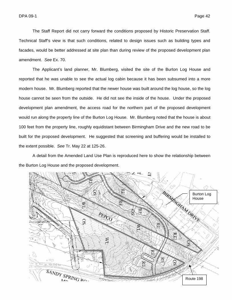
A detail from the Amended Land Use Plan is reproduced here to show the relationship between
the Burton Log House and the proposed development.
Burton Log House
Route 198
DPA 09-1 Page 43
The Burton Log House is on a corner property, so it fronts on two small, residential streets and
is surrounded on three sides by single-family homes. The proposed development would place a road
and single-family homes along a third side of the historic site, in a relationship that would appear no
different from the historic site’s current surroundings. In the Hearing Examiner’s view, any impact of the
proposed project on this historic resource can be appropriately addressed during site plan review.
J. Community Support
Fairland resident Stuart Rochester, Chair of the Fairland Master Plan Citizens’ Advisory
Committee (the “Fairland CAC”), spoke in support of the proposed development at the Planning
Board’s hearing, on behalf of the Fairland CAC, and submitted his testimony to the Hearing Examiner
with an accompanying letter. See Exs. 58 and 58(a). Mr. Rochester described the proposed project as
a high-priority Master Plan goal for the last decade. He acknowledged that the plan as now configured
is not all that was once envisioned, but called it “a welcome addition to a long-neglected part of the
planning area. . . .” and “a major enhancement to improving the demographic and housing makeup of
the east side of US 29. . . “ Exs. 58(a), 58. Mr. Rochester stated that the Fairland CAC had worked
closely with the Applicant and Technical Staff to resolve a host of issues. He noted the Master Plan’s
emphasis on increasing the number of single-family detached homes in Fairland, given the
overconcentration of apartments and townhouses in the planning area that resulted from the 1981
master plan.
Mr. Rochester described the contentions of the Greencastle Lakes Community Association as
based on inaccuracies, noting that Greencastle Lakes representatives participated in drafting the
Master Plan. See Ex. 58. He considered their concern about school crowding inexplicable, in light of
the “key and hard-fought-for provision” requiring a school site. See id.
K. Opposition
The record contains three letters in opposition, one from Ms. Binder and two from Mr.
Kloosterhuis. See Exs. 48, 56 and 57. The substance of these letters is addressed in the preceding
sections on the environment and public facilities, Parts III. G and H.
DPA 09-1 Page 44
IV. SUMMARY OF HEARING
Except where explicitly stated, all of the testimony was provided before the announcement that
the MNCPPC may purchase a substantial portion of the property, and refers to the plan as proposed
without the MNCPPC purchase.
A. Applicant’s Case in Chief
1. Bernard J. Rafferty, Applicant’s representative. Tr. May 22 at 9-84, 200-202; Tr. June 2 at 4-
24.
Mr. Rafferty is a professional engineer with 30 years’ experience in land development. He is an
officer in both of the entities constituting the Applicant in this case. Mr. Rafferty explained the evolution
of the plans for the subject property since 2004, including the eventual agreement between the
Applicant and the MNCPPC to allow residential development to go forward on the privately owned
portions of the site while preserving the publicly owned parts as parkland. He noted that in December
2006 the Applicant purchased a 26-acre tract in the middle of the subject property, formerly used as a
stump dump, which the Master Plan considered part of Parcel X.6 Mr. Rafferty stated that the County
had long intended to purchase Parcel X for park and school use, but when the magnitude of the clean-
up costs became apparent, the MNCPPC indicated that the Applicant would have to purchase the
property itself if it wished the proposed project to go forward. The Applicant viewed the tract as
important for its road frontage and for the efficient and safe circulation of roads through the planned
residential community, so it made the 26-acre purchase and began the clean-up process. The
Applicant entered into a consent agreement with the MDE to close down the stump dump and reclaim
the land. Since then, the property has been fenced off, all illegal dumping activity has stopped, and all
surface trash and debris has been removed.
Mr. Rafferty opined that the plan now proposed for the subject property would be consistent with
the Master Plan’s recommendation for a predominantly single-family detached housing project in this
area with a high attention to details and an amenity package worthy of a “move-up market,” all of which
6 The remainder of Parcel X is owned by the MNCPPC, and is shown on the Amended Land Use Plan as G-813, Part III. See Tr. May 22 at 74; Ex. 82(a).
DPA 09-1 Page 45
is severely lacking in the Fairland area. Mr. Rafferty emphasized that the Applicant has had many
conversations with the Fairland CAC, which helped draft the Master Plan, and is very aware of what is
required to achieve and retain its support. He noted that the proposed project would provide many of
the public benefits anticipated by the Master Plan, including an 11-acre school site that the Applicant
has committed to deed to the school system after grading it, installing stormwater management and
providing for forest conservation requirements. Mr. Rafferty reported that the school system provided
the Applicant with a sample school layout to make sure it would fit on the proposed site, and is very
pleased with the site’s size and configuration. In addition, the Applicant has committed to preserve 22
acres of upland forest in excess of the required minimum, in a high-priority area that would have been
cleared for the 2004 plan. The Applicant has also committed to dedicating (by deed) approximately 22
acres of park land adjacent to McKnew Local Park. The park dedication would link the existing, 22-acre
McKnew Local Park with 14 acres of park property just north of the former stump dump, creating 60
acres of contiguous park land. Mr. Rafferty also noted that the proposed development would have an
extensive pedestrian trail system connecting to existing public trails in Fairland Recreational Park.
Mr. Rafferty described many environmental benefits of the present plan:
Compared to the 2004 plan, the present plan would result in 26 acres less of stream
buffer encroachment, almost ten acres less of tree removal within the stream buffer, and
the reclamation of over 40 acres of mined and otherwise degraded land that is causing
sediment and other environmental problems.
The Applicant plans to enlarge existing ponds on its property to provide for flood
protection on its property and downstream, to be available to the Parks Department as a
possible source of irrigation water for the Gunpowder Golf Course.
Any wetlands affected by the proposed development would be replaced onsite.
Forest conservation requirements would be exceeded, with no need for afforestation.
High-priority forest would be preserved in the northern part of the site, and the southern
spike would be untouched.
DPA 09-1 Page 46
Mr. Rafferty emphasized that the Applicant has stayed true to the Master Plan’s objectives, even
though doing so required reducing the number of homes from 396 to 365.
Mr. Rafferty testified that the Planning Board approved a preliminary plan of subdivision for the
subject property in December 2004, which is valid for 145 months. That approval, he noted, included a
finding that the 396-unit development then proposed satisfied the Adequate Public Facilities Ordinance.
Mr. Rafferty outlined the phasing of the proposed plan and explained that the school site cannot
be dedicated any earlier than the final plat issuance in Phase Two because onsite infrastructure, such
as water, sewer and roads, must be completed before the land is turned over to MCPS. This timing, he
noted, is consistent with the phasing in the 2004 plan.
Comparing the current plan for 365 homes with the 2004 plan for 396 homes, Mr. Rafferty
observed that the layouts in the northern part of the site, near Route 198, are very similar, except that a
road extension and five homes on the Prince George’s County side of the boundary have been
removed. Farther south, all of the homes that in 2004 were shown on publicly owned land have been
removed, so that all of the proposed home lots are now shown on privately owned land. All lots shown
within Fairland Recreational Park in 2004 have been removed. The school site is in the same general
area now as in 2004, although it has been shifted slightly to allow a better traffic link to existing local
roads.
Mr. Rafferty affirmed the Applicant’s commitment to disperse MPDUs throughout the site, with
no more than 16 units in one location. See Tr. May 22 at 53.
With regard to the Prince George’s County part of the project, Mr. Rafferty stated that the
current concept is for 148 residential units, using a “public benefit conservation subdivision option” that
requires a higher standard of forest and park conservation.
Mr. Rafferty noted that the Applicant has met with numerous civic associations in the area, in
addition to the Fairland CAC, and plans to continue those contacts throughout the development
process. In his view, the present proposal is most definitely responsive to concerns that have been
expressed by local residents. He testified at the second hearing that between the first and second
sessions he met with the Greencastle Lakes Community Association, whose concerns appeared to be
DPA 09-1 Page 47
resolved when he provided some details about the proposed plans and assured them that the proposed
development would never connect to Greencastle Road. See Tr. June 2 at 23.
In response to questions from a community member, Mr. Rafferty stated that no construction is
currently underway on the subject site, but there is reclamation activity underway on a mining area
adjacent to the site in Prince George’s County, which the Applicant has a contract to purchase.
Mr. Rafferty stated that the proposed development would have no connection to and therefore
no impact on Greencastle Road. He disagreed with the contention that Route 198 is impossible to
navigate at some times of day due to traffic congestion, noting that the traffic study performed in
connection with the 2004 rezoning indicated that all roads in the area operate satisfactorily. See Tr.
May 22 at 81. In response to a question about the adequacy of police and fire services, Mr. Rafferty
cited the Planning Board’s 2004 finding that the 396-unit development satisfied the Adequate Public
Facilities Ordinance, including police and fire services.
At the second hearing session, Mr. Rafferty reported that during the process of amending the
development plan, the Parks Department and Environmental Planning Division at MNCPPC always had
an interest in the subject property, particularly the area near McKnew Local Park and the northern part
of the site, which is substantially forested and vital to the headwaters in the area. He testified that
MNCPPC felt the 23-acre park dedication was the most they could legally require in connection with the
proposed Development Plan Amendment, so there were negotiations about a possible purchase of
additional land, parallel to the present application process. Mr. Rafferty stressed that he was not in a
position to make any public statement about the negotiations before the Planning Board’s vote on May
28, 2009. He stated that the Parks Department has now entered into a potential contract to purchase
all of the lots in Phase III of the G-813 residential development area, plus the G-814 property, with the
understanding that the property would be encumbered by the development plan for which the Applicant
currently seeks approval. See Tr. June 2 at 6-7. He testified that the County’s appraisal of the property
was based on approval of the proposed development plan amendment.
Mr. Rafferty testified that if the sale goes through, the Applicant can still do a complete school
dedication and the park dedication, the transportation network will stay intact, and they will seek
DPA 09-1 Page 48
approval at preliminary plan and site plan for the remaining lots. Mr. Rafferty began to say that the
Parks Department could then use the land they acquire for open space, or sell some of it for another
use. The Hearing Examiner explained that if the proposed development plan amendment were
approved as originally submitted, the Parks Department would not have the option to use or sell the
land for any purpose other than what is shown on the approved Development Plan, unless they come
back to the District Council for another development plan amendment. This discussion resulted in the
Applicant adding language to the Amended Land Use Plan specifying that if the land is sold to the
MNCPPC, it will be designated as parkland. See Tr. June 2 at 9-18.
Mr. Rafferty testified that his discussions with the Parks Department included a provision for an
easement over the land to be sold, if necessary, to meet forest conservation and other legal
requirements. Mr. Rafferty believes that such an easement will not be necessary, but noted that it will
be available if needed, under the expected terms of sale. See Tr. June 2 at 7-8.
2. Alfred Blumberg, land planner. Tr. May 22 at 84-93, 108-139; June 2 at 24-30.
Mr. Blumberg was designated an expert in land planning. Mr. Blumberg described the subject
property and its surroundings using an aerial photograph, pointing out that about two thirds of the
existing housing stock in the vicinity is townhouses, which he described as the reason the Master Plan
established a goal of increasing the availability of single-family detached homes in the area. He noted
that no access from the proposed development to Greencastle Road is existing or proposed. Mr.
Blumberg identified Gunpowder Golf Course and the many recreational facilities in Fairland
Recreational Park that are outside the subject property and are accessed from Greencastle Road,
noting that the forested open space in the “southern spike” of the subject property lies between the golf
course and the developed area of the park.
Mr. Blumberg identified the several parts of the proposed Amended Land Use Plan, which
separates the privately owned land proposed for residential development from the publicly owned land
proposed for continued park use. He elaborated on Mr. Rafferty’s testimony about the 26-acre former
stump dump, explaining that part of the area is to be reclaimed to a level that will permit its use for a
DPA 09-1 Page 49
swimming pool and community center, while the rest will be capped with a membrane and four feet of
topsoil and kept as permanent open space. See Tr. May 22 at 92.
In response to concerns raised by community members about fire protection, Mr. Blumberg
maintained that there is no reason to question the finding of adequacy that the Planning Board made
during subdivision review of the 2004 Development Plan. He presented evidence indicating that the
nearest fire station to the subject site is about 3 miles away, at the intersection of Briggs Chaney Road
and Old Columbia Pike. He noted, in addition, that a representative of Fire and Rescue participated in
the discussion of this case by the MNCPPC Development Review Committee, and did not raise any
concerns about the proposed development. See Tr. May 22 at 109-110.
Mr. Blumberg noted that there is a police substation on Briggs Chaney Road east of Route 29,
about 3.5 miles from the subject site, although he conceded that it is not a 24-hour, fully staffed
location. He stated that the bank robbery Ms. Binder mentioned took place in Clarksville, in Howard
County, and the suspects were chased into Greencastle Lakes, where they were captured.
Mr. Blumberg suggested that the additional roadways planned for the proposed development
would improve access to the existing neighborhoods off of Saddle Creek Drive and Cedar Tree Drive,
immediately north of the subject property. This is true, however, only if the portion of the development
proposed in Prince George’s County goes forward and a roadway connection is approved from the
Montgomery County side to Old Gunpowder Road in Prince George’s County. See Tr. May 22 at 113-
114.
Mr. Blumberg affirmed his opinion that the proposed development would be in substantial
compliance with the Master Plan, satisfying it as well as possible given the failure of the original plan.
See Tr. May 22 at 121-22, 128-29. He particularly addressed the Applicant’s request to waive the
minimum of 20 percent attached units called for in the PD Zone, to better serve the Master Plan’s goal
to increase the percentage of single-family detached housing in this area. See Tr. May 22 at 122. He
opined that the proposed development would provide balance in the development of the neighborhood,
including MPDUs; would create pedestrian circulation and connectivity that does not currently exist;
DPA 09-1 Page 50
would provide on-site recreation and connection to recreational opportunities in Fairland Recreational
Park; and would have far fewer environmental impacts than the 2004 plan.
At the second hearing session, Mr. Blumberg submitted letters from the police department and
the fire department stating that both are able to provide adequate services to the area of the subject
site, and would not be overburdened by the proposed 365-unit development. See Tr. June 2 at 25-27;
Exs. 72 and 73. He also submitted a page from the County’s CIP showing that a police station located
on Sligo Avenue in Silver Spring is proposed to be moved to a location near the intersection of New
Hampshire Avenue and Route 29 some time in 2011 or 2012. See id. at 28-29. Mr. Blumberg opined
that police and fire protection would be adequate to serve the proposed development.
3. Wes Guckert, traffic engineer. Tr. May 22 at 139-152.
Mr. Guckert was designated an expert in transportation planning and traffic engineering. He
testified that the proposed 365-unit development represents a decrease of 7.8 percent in the number of
units compared to the 2004 plan. He stated that the access would remain basically the same under the
current plan, with two points of access for the southern residential area, one at Cedar Tree Drive and
one at Saddle Creek Drive, and access from Route 198 for the northern residential area. He confirmed
Mr. Blumberg’s testimony that if the Prince George’s County portion of the proposed plan goes forward,
Cedar Tree Drive and Saddle Creek Drive will connect to Old Gunpowder Road in Prince George’s
County.
Mr. Guckert stated that once subdivision approval has been granted, the Planning Board does
not require a new analysis under the APFO for a change in the plan unless the change results in more
than five additional peak hour trips. Here, the proposed Development Plan Amendment would result in
fewer trips, so no additional analysis is required. See Tr. May 22 at 141-42. Mr. Guckert’s testimony
about area roadway conditions is summarized in Part III. H. above.
4. Marc Anthony Mezzanotte, Tr. May 22 at 153-177; 202-203; June 2 at 37-39.
Mr. Mezzanotte was designated an expert in civil engineering. He described the process of
preparing the NRI/FSD, obtaining approval for it, and using it as the basis for the preliminary forest
conservation plan. He described the storm water management plan under the proposed development
DPA 09-1 Page 51
plan amendment as more compact than under the 2004 plan, with ponds a little more strategically
located and a little more efficient. See Tr. May 22 at 162-63. Mr. Mezzanotte confirmed that a concept
stormwater management plan was approved by DPS late last year, although that concept did not
include the school site because its location had not been determined. He stated that a new concept
plan has been submitted to DPS with the school site included. He opined that the plan complies with all
relevant county and state requirements, and he expects it to be approved. See id. at 163, 165.
Mr. Mezzanotte agreed with earlier testimony that the Master Plan’s recommendations for road
network extensions would be met by the extension of Saddle Creek Drive, and opined that the
proposed road network would be safe and efficient from a civil engineering perspective. See id. at 170,
172. He pointed to sidewalks on both sides of the streets and bicycle paths throughout the community
as evidence of a good circulation plan. Mr. Mezzanotte observed that in keeping with the Master Plan,
stormwater management facilities had been located outside of the stream buffers where feasible. He
observed that the new plan would require only one road crossing of the stream that runs through the
site, rather than the two crossings that were shown on the 2004 plan to accommodate the length of the
golf holes. He considers this beneficial because it preserves more of the wooded wetland around the
stream.
Turning to the purposes of the PD Zone, Mr. Mezzanotte point out that the proposed plan would
preserve 87 percent of the green spaced on the subject property, and would improve water quality in
the Little Paint Branch by stabilizing areas along the stream that now have sedimentation problems. He
observed that the street layout was designed to minimize grading and land disturbance to a greater
degree than could be done under a conventional zone, due to the ability to have smaller lots and
development pods, as well as a phasing plan that will aid in curtailing soil erosion and providing natural
vegetation more quickly to stabilize some areas.
Mr. Mezzanotte confirmed that all necessary utilities exist within the subject property or on
external roads, and that WSSC has indicated water and sewer will be adequate. See id. at 173.
DPA 09-1 Page 52
Mr. Mezzanotte agreed with Mr. Rafferty’s testimony that if the MDE denies the request to fill
some isolated wetlands, the roads and sidewalks can be shifted slightly while still providing good
connections. See Tr. May 22 at 202-203.
At the second hearing session, Mr. Mezzanotte testified that he does not anticipate the
Applicant needing an easement for forest conservation purposes over any of the land potentially to be
sold to MNCPPC, unless the school construction results in clearing the full 1.7 acres of land on the
school site that is currently shown as forest conservation. Even then, the Applicant would only need an
easement over 0.3 acres of land, which Mr. Mezzanotte considers very minimal. See Tr. June 2 at 37-
39.
5. John Markovich, forester. See Tr. May 22 at 178-198.
Mr. Markovich was designated an expert in forestry, which he described as looking at a forest,
evaluating it and making management recommendations for dealing with groups of trees on a
landscape scale, as opposed to an individual tree scale. He contrasted his profession with that of an
arborist, who deal with individual trees. See Tr. May 22 at 179. Mr. Markovich helped prepare the
NIR/FSD in this case, as well as the preliminary forest conservation plan. He found several different
forest stands on the subject property, some early succession conifer, some middle age conifer and
some mature conifer, as well as some early succession hardwoods and immature hardwoods, and one
area of immature climax forest. He explained that “early succession” means a forest that generally has
pioneer species such as pines, cherries and black locusts, in an area that is just beginning to
regenerate with forest. The seeds of these species are very light, so they can float quite a distance. In
this case, the early forests are on former gravel mining sites that are now regenerating. After early
succession forest comes immature forest, then climax.
Mr. Markovich opined that the proposed development plan amendment would be consistent with
the Master Plan’s environmental recommendations, as described in Part III. F. above.
Mr. Markovich explained that based on the forest clearing involved in the proposed plan, the
reforestation requirement would normally be 18.46 acres, but the Applicant has received credit for
21.65 acres of forest retention above the required level, so that covers the reforestation requirement.
DPA 09-1 Page 53
See Tr. May 22 at 191. He identified the largest area of extra forest retention as an area of immature
climax forest below McKnew Park, with most of the other areas in and around stream buffers.
Mr. Markovich opined that the proposed plan would take the greatest possible aesthetic
advantage of trees by providing edges along priority forest areas and streams, and views into the forest
from a couple of different areas. He considers the proposed forest conservation plan to be compatible
with surrounding uses from an environmental standpoint, because it will provide a lot of forest areas
that can be used for recreational trails, preserving forest while allowing people access to it. He opined
that the proposed plan would serve the public interest by preserving uninterrupted areas of forest, as
well as connectivity between different park areas and along stream valleys, providing important wildlife
and forest habitat.
Mr. Markovich responded to Ms. Binder’s comments by stating that the proposed development
plan amendment would protect the sensitive stream valley buffers, as required. He opined that any
type of development will result in losing some forest, so that cannot be avoided if development is to go
forward.
C. Opposition
Audrey Binder testified on behalf of the Greencastle Lakes Community Association and
submitted written comments.7 See Tr. May 22 at 95-107; Ex. 57. She is a lifelong resident of
Montgomery County, a 17-year resident of Greencastle Lakes and a certified environmental professional
with 35 years of environmental experience. Ms. Binder has worked for the United States Environmental
Protection Agency for the last 25 years.
Ms. Binder described Greencastle Lakes as a community of 822 homes located across from
Fairland Recreational Park. She stated that her community opposes the proposed development on
grounds that it will increase traffic, eliminate scarce parkland, harm sensitive environment, undercut
open space policies and increase population in an area that already has a lack of adequate schools,
7 Ms. Binder testified that the association’s Board of Directors contacted her and asked her to testify. The record does not contain a written authorization, but two other members of the association were present at the hearing with Ms. Binder, including the president of the Board of Directors.
DPA 09-1 Page 54
police and public safety. Ms. Binder’s testimony is summarized in Parts III. G. and H. above, under
Environment and Public Facilities.
D. People’s Counsel
The People’s Counsel, Martin Klauber, participated in the morning hearing session on May 22
and the June sessions. Having read the technical reports and attended the Planning Board hearing on
this matter, he reconfirmed that the Office of People’s Counsel supports the proposed development, as it
did in 2004. See Tr. May 22 at 107-108.
V. ZONING ISSUES
Zoning involves two basic types of classifications: Euclidean zones and floating zones. The
term “Euclidean” zoning arose from the seminal United States Supreme Court case upholding the land
use authority of local governments, Village of Euclid v. Ambler Realty Co., 272 U.S. 365 (1926).
Euclidean zoning divides the territory of a local jurisdiction into zoning districts with set boundaries and
specific regulations governing aspects of land development such as permitted uses, lot sizes, setbacks,
and building height. A floating zone is a more flexible device that allows a legislative body to establish a
district for a particular type of use, with land use regulations specific to that use, without attaching that
district to particular pieces of property. Individual property owners may seek to have property
reclassified to a floating zone by demonstrating that the proposed location is appropriate for the zone,
i.e., it satisfies the development standards and purpose clause for the zone, the development would be
compatible with the surrounding area, and it would serve the public interest.
PD (Planned Development) zones are a special variety of floating zone with performance
specifications integrated into the requirements of the zone. These zones allow considerable design
flexibility if the performance specifications are satisfied. The applicant is not bound to rigid design
specifications, but may propose site-specific specifications, within the parameters established for the
zone, for elements such as setbacks, building heights and types of buildings. These specifications must
be specified on a development plan, however, to assure appropriate zoning oversight by the District
Council. Pursuant to Code §59-D-1.11, development under the PD Zone is permitted only in
DPA 09-1 Page 55
accordance with a development plan that is approved by the District Council when the property is
reclassified to the PD Zone. Once it is approved, the development plan provides the design
specifications for the site, much as the Zoning Ordinance provides design specifications for more rigidly
applied zones. Accordingly, the evaluation of zoning issues must begin with the development plan and
proceed to the requirements of the zone itself.
A. The Development Plan
Before approving a development plan, the District Council must make five specific findings set
forth in Code § 59-D-1.61. These findings relate to consistency with the master plan and the
requirements of the zone, compatibility with surrounding development, circulation and access,
preservation of natural features, and perpetual maintenance of common areas. The required findings
are set forth below in the order in which they appear in the Zoning Code, together with the grounds for
the Hearing Examiner’s conclusion that the evidence in this case supports all of the findings required for
approval. The three proposed Development Plans are considered together, but it is important to note
that Development Plan G-813 Part I and G-814 can also satisfy all of the required findings on its own.
(a) That the zone applied for is in substantial compliance with the use and density indicated by the master plan or sector plan, and that it does not conflict with the general plan, the county capital improvements program or other applicable county plans and policies.
The purpose clause for the PD Zone establishes consistency with the master plan as an
important factor in applying the zone:
It is the purpose of this zone to implement the general plan for the Maryland-Washington Regional district and the area master plans by permitting unified development consistent with densities proposed by master plans. . . . it is intended that the zoning category be utilized to implement the general plan, area master plans and other pertinent county policies in a manner and to a degree more closely compatible with said county plans and policies than may be possible under other zoning categories. Code § 59-C-7.11.
In the present case, both the Planning Board and Technical Staff opined that the proposed
Development Plans are in substantial compliance with the use and density recommended in the Fairland
Master Plan, and the Hearing Examiner agrees. The proposed residential development, shown on
DPA 09-1 Page 56
Development Plan G-813 Part I and G-814, would be substantially consistent with the Master Plan’s
recommendation for up to 396 dwelling units with a mix of single-family detached homes and attached
units appropriate for the area, recognizing the need to increase the proportion of detached homes in the
area. The number of units cannot reach the maximum anticipated in the Master Plan while substantially
fulfilling the Master Plan’s environmental goals, so the number of units proposed represents a balancing
of Master Plan priorities. If the potential land sale to the MNCPPC is consummated, the number of units
will decrease to a maximum of 248, nearly 40 percent lower than the 396 units anticipated in the Master
Plan. This sale would represent a different balancing of the Master Plan’s residential and environmental
goals, but would still be substantially consistent with those goals, viewed as a whole.
The continued parkland use proposed on the publicly owned parts of the site, shown on
Development Plans G-813 Part II and G-813 Part III, would not fulfill the Master Plan’s goal of expanding
or reconfiguring Gunpowder Golf Course outside the stream valley, but it would retain the existing
recreational facilities and satisfy the Master Plan’s environmental goals. In light of the inability to obtain
approval from Prince George’s County for a plan that included an improved golf course, the proposed
Development Plans represent the best possible implementation of the Master Plan’s use and density
recommendations.
The proposed Development Plans would not conflict with the General Plan, which was amended
by the Master Plan, so that substantial compliance with the Master Plan effectively demonstrates
consistency with the General Plan. The preponderance of the evidence, as discussed in Part III.H.
above, supports the conclusion that the proposed Development Plans would not conflict with the Growth
Policy. The Planning Board approved a preliminary plan of subdivision for a larger residential
development on the subject site in 2004, which necessarily included a finding that public facilities
(including roads, schools and police and fire protection) were adequate to support the proposed
development and would not be adversely affected by it. No substantial, probative evidence was
presented in this case sufficient to outweigh that finding, which is still legally valid. On the contrary, the
preponderance of the evidence, discussed in Part III.H. above, fully supports the Planning Board’s APF
finding.
DPA 09-1 Page 57
(b) That the proposed development would comply with the purposes, standards, and regulations of the zone as set forth in article 59-C, would provide for the maximum safety, convenience, and amenity of the residents of the development and would be compatible with adjacent development.
1. Purposes of the Zone
The purpose clause for the PD Zone, found in Code §59-C-7.11, is set forth in full below, with
relevant analysis and conclusions for each paragraph following.
It is the purpose of this zone to implement the general plan for the Maryland-Washington Regional District and the area master plans by permitting unified development consistent with densities proposed by master plans. It is intended that this zone provide a means of regulating development which can achieve flexibility of design, the integration of mutually compatible uses and optimum land planning with greater efficiency, convenience and amenity than the procedures and regulations under which it is permitted as a right under conventional zoning categories. In so doing, it is intended that the zoning category be utilized to implement the general plan, area master plans and other pertinent county policies in a manner and to a degree more closely compatible with said county plans and policies than may be possible under other zoning categories.
It is further the purpose of this zone that development be so designed and constructed as to facilitate and encourage a maximum of social and community interaction and activity among those who live and work within an area and to encourage the creation of a distinctive visual character and identity for each development. It is intended that development in this zone produce a balance and coordinated mixture of residential and convenience commercial uses, as well as other commercial and industrial uses shown on the area master plan, and related public and private facilities.
It is furthermore the purpose of this zone to provide and encourage a broad range of housing types, comprising owner and rental occupancy units, and one-family, multiple-family and other structural types.
Additionally, it is the purpose of this zone to preserve and take the greatest possible aesthetic advantage of trees and, in order to do so, minimize the amount of grading necessary for construction of a development.
It is further the purpose of this zone to encourage and provide for open space not only for use as setbacks and yards surrounding structures and related walkways, but also conveniently located with respect to points of residential and commercial concentration so as to function for the general benefit of the community and public at large as places for relaxation, recreation and social activity; and, furthermore, open space should be so situated as part of the plan and design of each development as to achieve the physical and aesthetic integration of the uses and activities within each development.
DPA 09-1 Page 58
It is also the purpose of this zone to encourage and provide for the development of comprehensive, pedestrian circulation networks, separated from vehicular roadways, which constitute a system of linkages among residential areas, open spaces, recreational areas, commercial and employment areas and public facilities, and thereby minimize reliance upon the automobile as a means of transportation.
Since many of the purposes of the zone can best be realized with developments of a large scale in terms of area of land and numbers of dwelling units which offer opportunities for a wider range of related residential and nonresidential uses, it is therefore the purpose of this zone to encourage development on such a scale.
It is further the purpose of this zone to achieve a maximum of safety, convenience and amenity for both the residents of each development and the residents of neighboring areas, and, furthermore, to assure compatibility and coordination of each development with existing and proposed surrounding land uses. This zone is in the nature of a special exception, and shall be approved or disapproved upon findings that the application is or is not proper for the comprehensive and systematic development of the county, is or is not capable of accomplishing the purposes of this zone and is or is not in substantial compliance with the duly approved and adopted general plan and master plans. In order to enable the council to evaluate the accomplishment of the purposes set forth herein, a special set of plans is required for each planned development, and the district council and the planning board are empowered to approve such plans if they find them to be capable of accomplishing the above purposes and in compliance with the requirements of this zone.
1st paragraph: Master Plan implementation. As discussed under (a) above, the proposed
Development Plans would be in substantial compliance with the use and density recommended in the
Fairland Master Plan. The evidence fully supports a conclusion that the proposed Development Plans
would be in substantial compliance with the Master Plan’s other recommendations, as well, which are
summarized in Part III.F. above. The proposed development would include numerous elements directly
responsive to the Master Plan, all of which would be achieved, albeit on a smaller scale, even with the
potential land sale to the MNCPPC:
adding detached units to the housing mix;
improving the road network by connecting Cedar Tree Drive to Saddle Creek Drive,
and possibly to Old Gunpowder Road in Prince George’s County if approvals can be
obtained;
DPA 09-1 Page 59
providing an 11-acre school site to MCPS at no cost, with grading, forest conservation
and stormwater management provided by the Applicant, in a location that would allow
many children to walk to school;8
providing common open space for residents of the new community;
providing trails and pathways to connect the new neighborhoods and nearby existing
neighborhoods to one another and to the trail system in Fairland Recreational Park;
providing MPDUs dispersed throughout the development;
protecting a significant amount of environmental features such as stream valleys,
steep slopes, wooded areas and wetlands.
Second paragraph: social and community interaction, distinctive visual character, balanced
mixture of uses. The proposed development would achieve these objectives in several ways. It would
relieve the isolation of the existing Saddle Creek neighborhood immediately northwest of the subject
property by connecting it to the new development. A network of sidewalks and trails would connect the
neighborhoods on and off the subject property to other neighborhoods, the school site, on-site
recreational facilities and Fairland Recreational Park. If the Prince George’s County part of the project
moves forward, the combined project will provide a vehicular connection across the county line,
improving access for residents of the new community and the Saddle Creek neighborhood. The
proposed development would provide the location for a community school that would be within walking
distance for many students and would serve as a focal point, bringing the community together. It would
increase recreational options for the Saddle Creek community by providing pedestrian linkages to
Fairland Recreational Park. The character of the development would revolve around the large areas of
open space created by the forested areas, stream valleys and proximity to Fairland Recreational Park,
all of which would give the community a distinct visual character and identity. No commercial uses are
proposed, in keeping with the size of the proposed residential development.
8 The 11-acre size of the site is smaller than the 12 to 15 acres mentioned in the Master Plan, but MCPS supports the plan, and preliminary drawings indicate that a model school layout fits on the site. See Staff Report at circle 41; Ex. 34(b).
DPA 09-1 Page 60
Third paragraph: broad range of housing types. The proposed development would contribute to
providing a broad range of housing types by increasing the proportion of single-family detached housing
available in the Fairland area, and by providing both market rate and MPDU units on site.
Fourth paragraph: trees and grading. The proposed development would result in substantial
forest clearing, an impact that would be practically unavoidable with any development at or near the
density recommended in the Master Plan. The amount of forest clearing would be lower for the
proposed Amended Land Use Plan than on the 2004 plan, down from 99 acres to 74. Moreover, the
written binding elements on the Amended Land Use Plan commit the Applicant to convey 23 acres of
high-priority forest to the MNCPPC as parkland, free of charge. This dedication is an important
environmental benefit, as it would link existing parkland on the east side of the site, represented by
Development Plan G-813 Part II, with McKnew Local Park just west of the subject site. This linkage
would create a 60-acre area of contiguous, forested parkland, which is much more valuable as habitat
and for aesthetic benefit than isolated pockets of similar land.
In addition to the parkland dedication, the Applicant’s preliminary forest conservation plan, Exs.
40(m), (n) and (o) and Ex. 77, provides for forest retention on-site that exceeds both the regulatory
reforestation requirements and the applicable conservation threshold. The Hearing Examiner is
persuade that the proposed Development Plans would take the greatest possible aesthetic advantage of
the trees by providing edges along priority forest areas and streams, and views into the forest from a
variety of areas. The significant forest preservation on site and in the parkland dedication area would
also take aesthetic advantage of the trees by preserving large areas of contiguous forest as an amenity
for all nearby residents, not just the new development.
The evidence indicates that while grading will be necessary due to the rolling topography of the
site and degraded conditions in some areas, it will be minimized to protect trees, where feasible and
appropriate.
Fifth paragraph: open space and physical/aesthetic integration of uses. The Development Plans
would preserve substantial amounts of open space as parkland, conveniently located and available to
the public as well as site residents. The proposed development would improve access to existing open
DPA 09-1 Page 61
space in Fairland Recreational Park by creating pedestrian trails linking the park with the nearby Saddle
Creek neighborhood, and potentially with the proposed Prince George’s County neighborhood if that
part of the plan goes forward. Moreover, the flexibility of the PD Zone and the design of the Amended
Land Use Plan would result in a high degree of integration, both physical and aesthetic, between the
new residences and existing natural and recreational features on the site.
Sixth paragraph: pedestrian networks. The Development Plan includes a system of trails and
sidewalks that would tend to reduce reliance on the automobile by allowing residents to walk among the
residential and recreational areas, and enabling children who currently are bussed to school from the
neighboring Saddle Creek neighborhood, as well as many in the new community, to walk to school.
Seventh paragraph: scale. The PD Zone encourages, but does not require, development on a
large scale. Taken as a whole, the Development Plans cover approximately 314 acres and therefore
can be considered large scale.
Eighth paragraph, first part: safety, convenience and amenity. The proposed development
would provide a maximum of safety, convenience and amenity for residents and neighbors by providing
an improved local road network, a site for a neighborhood elementary school, pedestrian connections to
Fairland Recreational Park, an expanded McKnew Local Park and, for the new development, on-site
recreation facilities.
Eighth paragraph, second part: compatibility. Much of the Saddle Ridge development abutting
the subject property to the west, near the proposed school site, is classified under the R-200/TDR Zone.
The area was developed at higher density using density transfers from up-county, and primarily contains
townhouses. Areas north of the subject property and immediately west of the proposed northern
neighborhood contain large-lot single-family homes. The proposed development would consist primarily
of single-family detached homes, with duplex and townhouse MPDUs, integrated in a well-designed plan
intended to create a “move-up” neighborhood, in an area sorely in need of such housing. The proposed
residential development would require reclamation of severely degraded land, turning a blighted area
into something attractive and useful. As discussed in Part III.H. above, the preponderance of the
DPA 09-1 Page 62
evidence supports a conclusion that the proposed development would not be incompatible with the
surrounding area due to traffic impacts or other impacts on public facilities. The Hearing Examiner
concludes that both the proposed residential uses and the continued parkland uses would be compatible
with the surrounding area, preserving recreational opportunities and a significant amount of
environmental resources while improving the housing mix and reclaiming degraded land.
Ninth paragraph: three findings. The purpose clause states that the PD Zone “is in the nature of
a special exception,” and shall be approved or disapproved based on three findings:
(1) the application is or is not proper for the comprehensive and systematic development of the county;
(2) the application is or is not capable of accomplishing the purposes of this zone; and
(3) the application is or is not in substantial compliance with the duly approved and adopted general plan and master plans.
On my reading, this element of the purpose clause does not add new requirements, but reminds
the District Council of its responsibility to carefully consider whether the PD Zone would be appropriate
in the location for which it is requested. The conclusions drawn earlier in this section govern the findings
to be made here. Based on the preponderance of the evidence and for the reasons stated above, the
Hearing Examiner concludes that present applications are proper for the comprehensive and systematic
development of the County, in compliance with and capable of accomplishing the purposes of the zone,
and in substantial compliance with the General Plan and Master Plan.
2. Standards and Regulations of the Zone
The standards and regulations of the PD-2 Zone are summarized below, together with the
grounds for the Hearing Examiner’s conclusion that the subject site would continue to satisfy these
requirements with the approval of the proposed Development Plans.
Section 59-C-7.121, Master Plan Density. Pursuant to Code §59-C-7.121, “no land can be
classified in the planned development zone unless such land is within an area for which there is an
existing, duly adopted master plan which shows such land for a density of 2 dwelling units per acre or
higher.” The subject property is already classified under the PD Zone, having been recommended in
the Master Plan for development at a density of two dwelling units per acre or greater.
DPA 09-1 Page 63
Section 59-C-7.122, Minimum Area. Code §59-C-7.122 specifies several criteria, any one of
which may be satisfied to qualify land for reclassification to the PD Zone. These include sufficient gross
area to construct 50 or more dwelling units under the density category to be granted; and being
recommended for the PD Zone in a master plan but “so uniquely situated that assembly of a minimum
gross area to accommodate at least 50 dwelling units is unlikely or undesirable and the development of
less than 50 dwelling units is in the public interest.” Code § 59-C-7.122(e). The G-813 property has
enough land for more than 50 dwelling units, satisfying the first criteria. The G-814 property satisfies the
second criteria due to its size, shape and location next to the power lines. Taken as a whole, the
proposed Development Plans satisfy the minimum area requirement.
Section 59-C-7.131, Residential Uses. Pursuant to Code §59-C-7.131, all types of residential
uses are permitted, but parameters are established for the unit mix. A development with 200 to 800
units is required to have a minimum of 30 percent single-family detached units and 20 percent
townhouse and single-family attached units. LMA No. G-813 falls within this category but has a mix of
87 percent single-family detached units and 13 percent single-family attached. A development with
fewer than 200 units, such as LMA No. G-814, is required to have a minimum of 35 percent single-family
detached units and 35 percent townhouse and single-family attached units. The small number of units
proposed within G-814 are all single-family detached homes, in keeping with nearby homes on the other
side of the power lines.
The Applicant requests waivers of the above unit mix requirements pursuant to Code § 59-C-
7.131, note 1, which authorizes the District Council to waive the unit mix requirements if it finds that “a
proposed development . . . achieves goals, policies or recommendations stated in an approved and
adopted master or sector plan.” The Department of Housing and Community Affairs (“DHCA”) objected
to the waiver requested for the G-813 portion of the development, arguing that the proposed
development should include market-rate townhouses.
Environmental Planning Staff observed that a higher density configuration with more attached
units would save more priority forests. They nonetheless supported the waiver, because the proposed
DPA 09-1 Page 64
development would achieve other Master Plan environmental goals such as preserving high-priority
upland forest and continuing the restoration of degraded areas. See Staff Report at circle 27.
In light of the Master Plan’s emphasis on increasing the number of detached homes in the
Fairland area, which already has a large representation of apartments and townhouses, the Hearing
Examiner agrees with the conclusions drawn by Technical Staff and the Applicant’s experts that the
requested waivers should be granted.
Section 59-C-7.132, Commercial Uses. Commercial uses are permitted but not required under
the PD Zone. Parameters established for commercial uses are not applicable to the subject application,
which does not propose any commercial uses.
Section 59-C-7.133, Other Uses. Noncommercial community recreational facilities for the use of
residents, such as the tot lots, swimming pool, community building and parkland shown on the Amended
Land Use Plan, are permitted in the PD Zone.
Section 59-C-7.14, Density of Residential Development. The Zoning Ordinance provides the
following direction for the District Council in considering a request for the PD Zone (§ 59-C-7.14(b)):
The District Council must determine whether the density category applied for is appropriate, taking into consideration and being guided by the general plan, the area master or sector plan, . . . the purposes of the planned development zone, the requirement to provide [MPDUs], and such other information as may be relevant.
The present applications seek the low-density category of two dwelling units per acre, in keeping
with the recommendations of the Master Plan. The maximum number of units permitted under the
written binding elements represents an overall density of approximately two dwelling units per acre,
including MPDUs (365 units/183 acres). The Hearing Examiner concludes, based on the evidence of
record, that this low density level is appropriate for the subject property in light of the significant
environmental constraints on the site, the recommendations of the Master Plan and the density of
existing development in the surrounding area.
Section 59-C-7.15, Compatibility. As discussed in Part V.A. above, the Hearing Examiner finds
that the proposed development would be compatible with existing development in the surrounding area.
Moreover, the written binding elements on the Amended Land Use Plan show that the development
DPA 09-1 Page 65
would satisfy the setback specifications set forth in Section 59-C-7.15, which prohibit any building other
than a one-family detached residence within 100 feet of an adjoining one-family detached zone. The
Amended Land Use Plan does not include a binding element that responds to the specification in the
same section that no building may be constructed to a height greater than its distance from such
adjoining land. However, the submitted Land Planning Report states that the development would
comply with this requirement. See Ex. 51(b) at 19. The Amended Land Use Plan shows that only a
small number of residential lots would be adjacent to land that is recommended for single-family
detached zoning, and all of the buildings on those lots would be single-family dwellings. Under these
circumstances, it is reasonable to expect that the building heights would comply with the Zoning
Ordinance and that the Planning Board would ensure such compliance at site plan review.
Section 59-C-7.16, Green Area. The PD-2 Zone requires a minimum of 30 percent green area.
A written binding element on the Amended Land Use Plan commits the Applicant to providing at least 45
percent green space, defined as gross tract area less buildings, roads and driveways.
Section 59-C-7.17, Dedication of Land for Public Use. The Land Use Plan clearly identifies the
portions of the subject property to be dedicated to public use: the school site, the parkland dedication
and property needed for roads.
Section 59-C-7.18, Parking Facilities. Off-street parking must be provided in accordance with the
requirements of Article 59-E of the Zoning Ordinance. The Amended Land Use Plan shows preliminary
parking counts considerably higher than the two spaces per dwelling unit required for single-family
dwellings, including garage and tandem spaces. The plan also shows 37 parking spaces for the
community center, for which Article 59-E does not prescribe a parking requirement.
(c) That the proposed internal vehicular and pedestrian circulation systems and points of external access are safe, adequate, and efficient.
The evidence supports a finding that the proposed internal vehicular and pedestrian circulation
systems and points of external access would be safe, adequate, and efficient. The extension of Cedar
Tree Drive and Saddle Creek Drive would improve the local road network, benefiting both existing and
DPA 09-1 Page 66
new residents of the area. Likewise, the network of trails and sidewalks would provide valuable
pedestrian connections for both existing and new residents.
(d) That by its design, by minimizing grading and by other means, the proposed development would tend to prevent erosion of the soil and to preserve natural vegetation and other natural features of the site. Any applicable requirements for forest conservation under Chapter 22A and for water resource protection under Chapter 19 also must be satisfied. The district council may require more detailed findings on these matters by the planning board at the time of site plan approval as provided in division 59-D-3.
As discussed in Parts III.G and V.A(b)(1) above, the proposed Development Plans would
preserve a significant amount of the natural vegetation and other natural features of the site. The
Applicant has committed to conveying 23 acres of high-priority forest to the MNCPPC at no charge, as
parkland linking existing publicly-owned forests. Its preliminary forest conservation plan, which has
been approved by the Planning Board, provides for forest retention that exceeds all relevant regulatory
requirements. Uncontested evidence concerning stormwater management indicates that the proposed
development would comply with all applicable water protection requirements.
The proposed Development Plans would have significant environmental benefits compared to
the 2004 plan, as described in Part III.G above. These include preserving greater amounts of parkland,
high-priority forest, stream buffers and wetlands. The proposed residential development would also
provide the significant benefit of stabilizing and reclaiming severely degraded land, replacing it with
useful and attractive open space and recreational amenities. The Hearing Examiner considers this
finding to be satisfied.
(e) That any documents showing the ownership and method of assuring perpetual maintenance of any areas intended to be used for recreational or other common or quasi-public purposes are adequate and sufficient.
A homeowners’ association declaration of covenants, conditions and restrictions that has been
submitted in draft form adequately and sufficiently demonstrates the intended ownership and perpetual
maintenance of common areas.
DPA 09-1 Page 67
B. Public Interest
The Applicant must show that the proposed reclassification bears sufficient relationship to the
public interest to justify its approval. The State Zoning Enabling Act applicable to Montgomery County
requires that all zoning power must be exercised:
“. . . with the purposes of guiding and accomplishing a coordinated, comprehensive, adjusted, and systematic development of the regional district, . . . and [for] the protection and promotion of the health, safety, morals, comfort, and welfare of the inhabitants of the regional district.” [Regional District Act, Maryland-National Capital Park and Planning Commission Article (Art. 28), Md. Code Ann., § 7-110].
When evaluating the public interest, the District Council normally considers master plan
conformity, the recommendations of the Planning Board and Technical Staff, and any adverse impact
on public facilities. As discussed in Part V.A. above, the Hearing Examiner agrees with Technical Staff
and the Planning Board that the subject application would be in substantial compliance with the Master
Plan. The preponderance of the evidence also establishes that, as discussed in Part V.A.(a), the
proposed Development Plans would be adequately supported by and would have no material adverse
impacts on public facilities. To the contrary, the proposed residential development would include a park
dedication and school dedication that carry significant public benefits. If the County builds a new
elementary school on the site provided on the Amended Land Use Plan, the net result will be a
substantial benefit to school conditions at the elementary level, while creating a focal point for
neighborhood activity and community involvement.
In addition to the added parkland and forest retained on the subject site, the public would benefit
from the environmental restoration and reclamation the private developers would perform on land that
is currently bare and causing sedimentation problems.
As the Opposition pointed out, some of the natural features on the subject property would be
adversely affected by the proposed development – trees would be cut down, some stream buffers
cleared and potentially some isolated wetlands filled. However, for the reasons stated in Part V.A
above, the Hearing Examiner is persuaded that the environmental costs associated with the proposed
DPA 09-1 Page 68
development are no greater than necessary to allow the Master Plan’s housing goals for the area to be
achieved, at least in part.
Accordingly, having carefully weighed the totality of the evidence, the Hearing Examiner
concludes that approval of the requested development plan amendment, creating Development Plan G-
813 and G-814, Development Plan G-813 Part II and Development Plan G-813 Part III, would be in the
public interest.
VI. CONCLUSIONS
Based on the foregoing analysis and after a thorough review of the entire record, I reach the
conclusions specified below.
1. The proposed Development Plans, taken together, are in substantial compliance with the
use and density recommended by the Fairland Master Plan and doe not conflict with the county capital
improvements program or any other county plan or policy.
2. The Development Plans would comply with the purposes, standards, and regulations of
the PD-2 Zone, would provide for the maximum safety, convenience, and amenity of the residents of the
development and would be compatible with adjacent development.
3. The Development Plans propose internal vehicular and pedestrian circulation systems
and points of external access that would be safe, adequate and efficient.
4. By its design, by minimizing grading and by other means including environmental
restoration and reclamation, the proposed development would tend to prevent erosion of the soil and
preserve natural vegetation and other natural features of the site. Applicable requirements for forest
conservation under Chapter 22A and for water resource protection under Chapter 19 would be satisfied.
5. The submitted documentation of the intended ownership and method of perpetual
maintenance of areas to be used for recreational or other common or quasi-public purposes is adequate
and sufficient.
6. The proposed development plan amendment would have no adverse effects on public
facilities and would serve the public interest.
DPA 09-1 Page 69
VII. RECOMMENDATION
I, therefore, recommend that Development Plan Amendment Application No. 09-1, seeking to
amend the existing development plan approved in conjunction with Zoning Applications G-813 and G-
814, be granted in the amount requested and the three proposed Development Plans approved, subject
to the specifications of the Amended Land Use Plan, Exhibit 82(a), which forms their central component,
as well as the Phasing Plan, Exhibit 82(b), and the depiction of the three Development Plans on Exhibits
25 and 39(f), provided, that within ten days of receipt of the District Council’s approval resolution, the
Applicant must submit a reproducible original and three copies of the approved Amended Land Use Plan
and Phasing Plan, Exhibits 82(a) and (b), for certification in accordance with § 59-D-1.64 of the Zoning