+ All Categories
Home > Documents > DRAFT Central Polk Parkway Project Development ...

DRAFT Central Polk Parkway Project Development ...

Date post: 07-Apr-2022
Category:
Upload: others
View: 1 times
Download: 0 times
Share this document with a friend
108
Central Polk Parkway Project Development & Environment Study State Environmental Impact Report Florida Department of Transportation Florida’s Turnpike Enterprise Central Polk Parkway from US 17 (SR 35) to SR 60 Project Development and Environment Study Polk County, Florida Financial Project ID: 440897-4-22-01 November 2019 January 2021 DRAFT
Transcript

Central Polk Parkway

Project Development & Environment Study

State Environmental Impact Report

Florida Department of Transportation

Florida’s Turnpike Enterprise

Central Polk Parkway from US 17 (SR 35) to SR 60

Project Development and Environment Study

Polk County, Florida

Financial Project ID: 440897-4-22-01

November 2019

January 2021

DRAFT

STATE ENVIRONMENTAL IMPACT REPORT FORM

FDOT FORM NO. 650-050-43

ENVIRONMENTAL MANAGEMENT, REV. 12/18

ii

1. PROJECT DESCRIPTION AND PURPOSE AND NEED:

a. Project Information:

Project Name: Central Polk Parkway Project Development and Environment Study

Project Limits: From US 17 (SR 35) to SR 60

County: Polk

ETDM Number (if applicable): 14372

Financial Project Number: 440897-4-22-01

Project Manager: Stephanie Underwood, P.E., Florida's Turnpike Enterprise (HNTB)

b. Proposed Improvements:

The proposed improvements evaluated in this study will extend the Central Polk Parkway and include new

toll facilities, a parallel multi-use trail, an interchange at US 17, a signalized intersection at SR 60, stormwater

management facilities (SMFs), floodplain compensation sites (FPCs), structural accommodations, and access

management modifications.

A detailed description is provided in Attachment 1B.

c. Purpose and Need:

The purpose of the proposed improvements is to improve regional connectivity, enhance freight mobility and

economic competitiveness, improve emergency evacuation times, and accommodate future population growth.

According to the University of Florida's Bureau of Economic and Business Research (BEBR), the population of Polk

County is estimated to grow from 661,645 (2017) to 906,100 by 2040 (a 37% increase). The Central Polk Parkway

(CPP) from US 17 (SR 35) to SR 60 is anticipated to accommodate the increased travel demand expected from the

projected freight, residential and employment growth.

The addition of a new alternative north-south facility to the regional transportation network will relieve congestion

from parallel facilities, including truck traffic, in central Polk County, particularly US 98 (SR 700), SR 540, US 17 (SR 35)

and SR 60. The CPP will provide additional connections to the local roadway network and Strategic Intermodal System

(SIS) facilities such as Polk Parkway (SR 570), US 98 (SR 700) and SR 60. The Polk Parkway is a beltway route that

provides connections from Interstate 4 (I-4) to Polk County cities such as Winter Haven, Bartow, Auburndale, and the

south side of Lakeland. SR 60 provides coast to coast connections including freight movement to and from the

Florida's Gateway Intermodal Logistics Center. US 98 (SR 700) provides north-south connections throughout Polk

County.

Project Background

A Project Development and Environment (PD&E) study, for the Central Polk Parkway, concluded in March 2011 with

the State Environmental Impact Report. This PD&E study evaluated a new six-lane facility with two recommended

alternatives. The Western Leg Alternative (SR 60 to the Polk Parkway (SR 570) and Eastern Leg Alternative (SR 60 to I-

DRAFT

STATE ENVIRONMENTAL IMPACT REPORT FORM

FDOT FORM NO. 650-050-43

ENVIRONMENTAL MANAGEMENT, REV. 12/18

iii

4). The design for Segment 1 (Polk Parkway to US 17) of the 2011 PD&E Western Leg was partially completed by FDOT

District One and placed on hold in December 2015.

The north/south connection, being evaluated as part of this effort, from SR 60 to US 17 was not evaluated as part of

the previous Central Polk Parkway PD&E study. It should also be noted that the Central Polk Parkway nomenclature is

still being utilized, but the focus of this facility has been substantially revised to current and future year conditions.

Consistency with Planning Documents

The Polk Transportation Planning Organization (TPO) Long Range Transportation Plan (LRTP) Momentum 2040,

identified a new limited access facility through the project area as a high priority project that has the potential to be

added to the future LRTP, pending funding.

This project is documented in the Statewide Transportation Improvement Program (STIP) under Item Number

440897-3. It is documented as the Central Polk Parkway from US 17 (SR 35) to SR 60.

DRAFT

STATE ENVIRONMENTAL IMPACT REPORT FORM

FDOT FORM NO. 650-050-43

ENVIRONMENTAL MANAGEMENT, REV. 12/18

iv

d. Project Planning Consistency:

Currently

Adopted

CFP-LRTP

COMMENTS

Y TIP/STIP include 440897-3 Central Polk Parkway from US 17 (SR 35) to SR 60 includes funding for

PE, R/W, and Construction for this segment. TIP/STIP include FPID # 440897-4 PD&E Central Polk

Parkway from US 17 (SR 35) to SR 60 with funding only for PD&E phase.

PHASE

Currently

Approved

TIP*

Currently

Approve

d STIP

TIP/STIP

$

TIP/STIP

FY

COMMENTS

PE

(Final Design) Y Y

$7,134,169

/

$9,802,010

<FY2021-

FY2021

/

<FY2021-

FY2022

TIP FY<2021 $376,804; FY2021 $6,757,365 / STIP FY<2021 $299,186; FY2021 $9,452,824; FY 2022 $50,000

R/W Y Y $13,581,014

/

$20,014,223

<FY2021-

FY2024

/

<FY2021-

FY2024

TIP FY<2021 $47,587; FY2023 $600,000; FY2024 $12,933,427 / STIP FY<2021 $137,592; FY2021 $211,326; FY 2023 $10,800,000; FY 2024 $8,865,315

Construction Y Y $114,152,470

/

$154,325,042

<FY2021-

>2024

/

<FY2021->2024

TIP FY<2021 $429, FY2025 $111,992,041; FY >2025 $2,160,000 / STIP FY<2021 $10,547; FY>2024 $154,325,042

Note: Refer to Appendix A for pages from TIP/STIP/LRTP *Polk TPO Transportation Improvement Program FY 2020 – 2025

DRAFT

STATE ENVIRONMENTAL IMPACT REPORT FORM

FDOT FORM NO. 650-050-43

ENVIRONMENTAL MANAGEMENT, REV. 12/18

v

2. ENVIRONMENTAL ANALYSIS

Issues/Resources *Substantial Impacts? **Supporting Information Yes No Enhance NoInv

A. SOCIAL and ECONOMIC

1. Social [ ] [ X ] [ ] [ ] See Attachment 2A1

2. Economic [ ] [ ] [ X ] [ ] See Attachment 2A2

3. Land Use Changes [ ] [ X ] [ ] [ ] See Attachment 2A3

4. Mobility [ ] [ ] [ X ] [ ] See Attachment 2A4

5. Aesthetic Effects [ ] [ X ] [ ] [ ] See Attachment 2A5

6. Relocation Potential [ ] [ X ] [ ] [ ] See Attachment 2A6

B. CULTURAL

1. Historic Sites/Districts [ ] [ X ] [ ] [ ] See Attachment 2B1

2. Archaeological Sites [ ] [ X ] [ ] [ ] See Attachment 2B2

3. Recreation Areas [ ] [ ] [ ] [ X ] See Attachment 2B3

C. NATURAL

1. Wetlands and other Surface Waters [ ] [ X ] [ ] [ ]

See Attachment 2C1

2. Aquatic Preserves and Outstanding FL Waters

[ ] [ ] [ ] [ X ]

See Attachment 2C2

3. Water Quality and Stormwater

[ ] [ X ] [ ] [ ]

See Attachment 2C3

4. Wild and Scenic Rivers [ ] [ ] [ ] [ X ] See Attachment 2C4

5. Floodplains [ ] [ X ] [ ] [ ] See Attachment 2C5

6. Coastal Barrier Resources [ ] [ ] [ ] [ X ] See Attachment 2C6

7. Protected Species and Habitat

[ ] [ X ] [ ] [ ]

See Attachment 2C7

8. Essential Fish Habitat [ ] [ ] [ ] [ X ] See Attachment 2C8

D PHYSICAL

1. Highway Traffic Noise [ ] [ X ] [ ] [ ] See Attachment 2D1

2. Air Quality [ ] [ X ] [ ] [ ] See Attachment 2D2

3. Contamination [ ] [ X ] [ ] [ ] See Attachment 2D3

4. Utilities and Railroads [ ] [ X ] [ ] [ ] See Attachment 2D4

5. Construction [ ] [ X ] [ ] [ ] See Attachment 2D5

6. Bicycles and Pedestrians [ ] [ ] [ X ] [ ] See Attachment 2D6

7. Navigation [ ] [ ] [ ] [ X ] See Attachment 2D7

* Substantial Impacts?: Yes = Substantial Impact; No = No Substantial Impact; Enhance =

Enhancement; NoInv = Issue absent, no involvement.

**Supporting information is documented in the referenced attachment(s).

DRAFT

FDOT FORM NO. 650-050-43

ENVIRONMENTAL MANAGEMENT, REV. 12/18

vi

3. ANTICIPATED PERMITS

☒ Individual 404 Permit – Florida Department of Environmental Protection (FDEP) (Section 7 Consultation with U.S.

Fish and Wildlife Service (USFWS) initiated with 404 permit)

☐ General 404 Permit - FDEP

☐ Bridge Permit - USCG

☒ Environmental Resource Permit (ERP) – Southwest Florida Water Management District (SWFWMD)

☒ Other: NPDES stormwater construction permit; USFWS and Florida Fish and Wildlife Conservation

Commission (FWC) Incidental Take Permits (as necessary); FWC Gopher Tortoise Permit

For guidance on ensuring sufficient information for permitting agencies see Section 10.2.1.4.1 of Part 1, Chapter

10 of the PD&E Manual

4. ENGINEERING ANALYSIS

Documented in the Central Polk Parkway Preliminary Engineering Report, January 2021.

5. COMMITMENTS

Commitments finalized after Public Hearing.

• The FTE will build a multi-use trail adjacent to the CPP limited access roadway pending an operation and maintenance

agreement with Polk County. After construction, the FTE will transfer the trail to Polk County for operation and maintenance.

• The FTE and their design consultant will continue to coordinate with the Florida Department of Transportation’s District One

staff for improvements along SR 60 within the project area.

• The FTE and their design consultant will coordinate with the Bartow Executive Airport to determine impacts to existing and

future airport uses.

• The FTE and their design consultant will continue to coordinate with the City of Winter Haven for water quality and

drainage improvements that could possibly be implemented into the design plans.

• During the design phase, a Level II Impact to Contamination Assessment will be conducted for locations with risk rating of

medium, if the identified contamination concerns have the potential to impact the proposed right-of-way (ROW) and/or

the project.

• The FTE will implement a land use review during the design phase to identify noise sensitive sites that may have received a

building permit subsequent to the noise study but prior to the Date of Public Knowledge (i.e., date that the SEIR was

signed). If the review identifies noise sensitive sites that have been permitted prior to the Date of Public Knowledge, then

those noise sensitive sites will be evaluated for traffic noise and abatement considerations.

• The FTE will conduct design-phase coverboard surveys in accordance with the most recent USFWS guidelines to verify activity

and occupancy status of the blue-tailed mole skink and sand skink.

• The FTE will conduct design-phase Florida scrub-jay surveys in accordance with the most recent USFWS guidelines in areas

of suitable habitat.

• The FTE will conduct design-phase crested caracara surveys in accordance with the most recent USFWS guidelines in areas

of suitable habitat.

• The FTE will conduct design-phase Florida bonneted bat surveys in accordance with the most recent USFWS guidelines.

• In an effort to mitigate impacts to protected plant species within the project study area, FTE will coordinate with FDACS and

coordinate with local native plant organizations prior to construction for possible relocation of protected plants.

• The USFWS Standard Protection Measures for the Eastern Indigo Snake will be implemented to assure that the Eastern indigo

snake will not be adversely impacted by the project.

• The FTE will conduct design-phase surveys in accordance with the most recent FWC guidelines to verify activity and

occupancy status of the Southeastern American kestrel.

• The FTE will conduct pre-construction surveys in accordance with the most recent FWC guidelines to determine the

occupancy status of the Florida burrowing owl and will adhere to the components of the Imperiled Species Management

DRAFT

FDOT FORM NO. 650-050-43

ENVIRONMENTAL MANAGEMENT, REV. 12/18

vii

Plan and permitting guidelines. If burrowing owls are found, the FTE will reinitiate technical assistance with the FWC to

discuss avoidance, minimization, and permitting options.

• If Florida sandhill crane nests are observed during future surveys conducted prior to construction, then a 400-foot buffer will

be implemented if construction occurs during the nesting season (January through July). The FTE will reinitiate technical

assistance with the FWC during the project construction phase, if necessary.

6. FDOT SELECTED ALTERNATIVE As a result of the alternatives analyses conducted for the project, a Preferred Alternative was identified for further

analysis and public input. The Preferred Alternative is documented in more detail in the Central Polk Parkway

Preliminary Engineering Report. The Preferred Alternative will be presented at the Public Hearing on February 9, 2021

for public input and comment.

The Preferred Alternative for the project includes the following proposed improvements as shown on the Concept

Plans provided in Appendix B:

• A typical section that provides a high-speed divided roadway with two 12-ft travel lanes in each

direction, 12-ft outside shoulders (10-ft paved), a 74-ft median, 8-ft inside shoulders (4-ft paved),

and open roadside ditches outside the roadway.

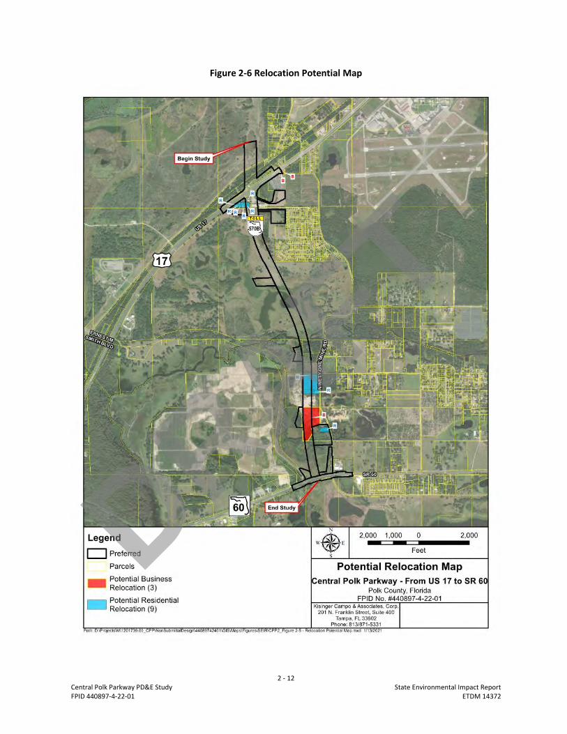
• The preferred alternative alignment consists of three horizontal curves and two tangential

segments linking the southern terminus of Central Polk Parkway Segment 1 with SR 60.

• A 12-foot multi-use recreational trail within a separate parallel 26-ft right-of-way corridor.

• An Interchange at US 17 and a signalized intersection at SR 60.

Other infrastructure improvements including bridges, stormwater and floodplain compensation ponds, intersection

improvements, access management changes (to median openings and driveway access), and multimodal

accommodations are included in the Preferred Alternative.

DRAFT

ix

Central Polk Parkway PD&E Study State Environmental Impact Report

FPID 440897-4-22-01 ETDM 14372

Contents

Contents ....................................................................................................................................................... ix

Acronyms and Abbreviations ..................................................................................................................... xiiii

Attachment 1 Project Description and Purpose and Need ........................................................................ 1-1

1A. Project Description ...................................................................................................................... 1-2

Project Background ........................................................................................................................ 1-2

Existing Conditions ......................................................................................................................... 1-4

1B. Proposed Improvements ............................................................................................................. 1-4

Alternatives Considered ................................................................................................................. 1-4

Alternatives Analysis ...................................................................................................................... 1-6

Preferred Alternative vs. No-Build Summary ................................................................................. 1-8

Preferred Alternative Typical Sections ......................................................................................... 1-10

Preferred Alternative Access Management ................................................................................. 1-12

1C. Purpose and Need ...................................................................................................................... 1-12

Attachment 2 Environmental Analysis ....................................................................................................... 2-2

2A. Social and Economic .................................................................................................................... 2-2

2A1. Social Resources .................................................................................................................... 2-2

2A2. Economic................................................................................................................................ 2-6

2A3. Land Use Changes .................................................................................................................. 2-6

2A4. Mobility .................................................................................................................................. 2-6

2A5. Aesthetics Effects ................................................................................................................. 2-11

2A6. Relocation Potential ............................................................................................................ 2-11

2B. Cultural Impacts ......................................................................................................................... 2-13

2B1. Historic Sites/Districts .......................................................................................................... 2-13

2B2. Archaeological Sites ............................................................................................................. 2-15

2B3. Recreational Areas ............................................................................................................... 2-15

2C. Natural Impacts .......................................................................................................................... 2-16

2C1. Wetlands and Other Surface Waters ................................................................................... 2-16

2C2. Aquatic Preserves and Outstanding Florida Waters ............................................................ 2-18

2C3. Water Quality and Stormwater ........................................................................................... 2-18

2C4. Wild and Scenic Rivers ......................................................................................................... 2-19

2C5. Floodplains ........................................................................................................................... 2-19

2C6. Coastal Barrier Resources .................................................................................................... 2-20

2C7. Protected Species and Habitat ............................................................................................. 2-21

2C8. Essential Fish Habitat ........................................................................................................... 2-22

2D. Physical Impacts ........................................................................................................................ 2-25

2D1. Highway Traffic Noise .......................................................................................................... 2-25

2D2. Air Quality ............................................................................................................................ 2-26

2D3. Contamination ..................................................................................................................... 2-27

DRAFT

x

Central Polk Parkway PD&E Study State Environmental Impact Report

FPID 440897-4-22-01 ETDM 14372

2D4. Utilities and Railroad ........................................................................................................... 2-28

2D5. Construction ........................................................................................................................ 2-30

2D6. Bicycle and Pedestrians ....................................................................................................... 2-30

2D7. Navigation ............................................................................................................................ 2-31

Attachment 3 References .......................................................................................................................... 3-1

Appendices

Appendix A Planning Documentation

Long Range Transportation Plan (LRTP)

Transportation Improvement Plan (TIP)

State Transportation Improvement Plan (STIP)

Appendix B Concept Plans for the Preferred Alternative

Concept Plans

Appendix C Cultural Resources Documentation

SHPO Concurrence

Appendix D Natural Resources Documentation

Wetlands and Surface Waters Map

USFWS, FWC, and SWFWMD Meeting Minutes

DRAFT

xi

Central Polk Parkway PD&E Study State Environmental Impact Report

FPID 440897-4-22-01 ETDM 14372

Tables

Table 1-1 Project Evaluation Matrix……………………………………………………………………………………….….………… 1-9

Table 2-1 Land Use Changes………………………………..…………….…………………………………………….…….….………… 2-8

Table 2-2 Potential Jurisdictional Wetlands and Other Surface Water Impacts……………….…………………. 2-16

Table 2-3 Summary of Listed Species Effect Determinations…………………………………………….………………… 2-23

Table 2-4 Screening Model Results …….…………………………………………………………………………..……………….… 2-27

Table 2-5 Estimated Impacts to Utilities………………………………………………………………………….……………….… 2-29

Figures

Figure 1-1 Project Area Map……………..…………………………………………………………………….…………….….………… 1-3

Figure 1-2 Alternative Alignments Considered………………………………………………………...…………………….……. 1-5

Figure 1-3 Preferred Alternative…………………………………………………………………………….…..………………….……. 1-7

Figure 1-4 Roadway Typical Section……………………………………………………………………….……..…….……..….….. 1-10

Figure 1-5 Typical Section Spans 1 and 2…………………………………………….………………….…………….….…….….. 1-11

Figure 1-6 Typical Section Span 3…………………………………………………………………………………………………….…. 1-11

Figure 2-1 Social Resources – Minority Location Map ……………………………………………....………………….……. 2-3

Figure 2-2 Social Resources – Poverty Level Map …………………………………………………..…………………….…….. 2-5

Figure 2-3 Economic and Mobility Map ……………………………………………………………….….…..……………..….…… 2-7

Figure 2-4 Existing Land Use Map …………………………………………………….……………….……….…………….…….….. 2-9

Figure 2-5 City of Bartow Future Land Use Map………………………………………………………………….……..….…… 2-10

Figure 2-6 Relocation Potential Map ……………………………………………………………………….….………………….…. 2-12

Figure 2-7 Cultural Resources Map ………………………………………………………………………….….………………….…. 2-14

Figure 2-8 Floodplain Map ……………………………………………………………………..……………….….………………….…. 2-20

Figure 2-98 Protected Species Map ……………………………………….……………………………….….………………….…. 2-22

DRAFT

xii

Central Polk Parkway PD&E Study State Environmental Impact Report

FPID 440897-4-22-01 ETDM 14372

Acronyms and Abbreviations ACI Archaeological Consultants Incorporation

AET all electronic tolling

AN Advance Notification

APE Area of Potential Effect

BFE base flood elevation

BEBR Bureau of Economic and Business Research

CD cross drain

dB decibels

CFR Code of Federal Regulations

CO carbon monoxide

CRAS Cultural Resources Assessment Survey

CSER Contamination Screening Evaluation Report

E Endangered

ECFCTF East Central Florida Corridor Task Force

EFH Essential Fish Habitat

ERP Environmental Resource Permit

ETAT Environmental Technical Advisory Team

ETDM Efficient Transportation Decision Making

EST Environmental Screening Tool

FDACS Florida Department of Agriculture and Consumer Services

FDEP Florida Department of Environmental Protection

FDEO Florida Department of Economic Opportunity

FDOT Florida Department of Transportation

FEMA Federal Emergency Management Agency

DRAFT

xiii

Central Polk Parkway PD&E Study State Environmental Impact Report

FPID 440897-4-22-01 ETDM 14372

FIRM FEMA Flood Insurance Rate Map

FLUCCS Florida Land Use and Cover Classification System

FLUCFCS Florida Land Use, Cover and Forms Classification System

FMSF Florida Master Site File

ft foot (feet)

FTE Florida’s Turnpike Enterprise

FPC floodplain compensation

FWC Florida Fish and Wildlife Conservation Commission

GIS geographic information system

ICPR Interconnected Channel and Pond Routing

LRE Long Range Estimates

mph mile(s) per hour

MSAT mobile source air toxics

NAC Noise Abatement Criteria

NAAQS National Ambient Air Quality Standards

NAVD North American Vertical Datum of 1988

NFIP National Floodplain Insurance Program

NRE Natural Resources Evaluation

NRHP National Register of Historic Places

OFW Outstanding Florida Waters

PD&E Project Development and Environment

PSR Pond Siting Report

RCUT Restricted Crossing U-turn

ROW right-of-way

SEIR State Environmental Impact Report

DRAFT

xiv

Central Polk Parkway PD&E Study State Environmental Impact Report

FPID 440897-4-22-01 ETDM 14372

SHPO State Historic Preservation Officer

SHWL seasonal high water line

SIS Strategic Intermodal System

SMF stormwater management facility

SR State Road

SWFWMD Southwest Florida Water Management District

T Threatened

UAO utility agency/owner

UCF University of Central Florida

UMAM Uniform Mitigation Assessment Method

USACE United States Army Corps of Engineers

USEPA U.S. Environmental Protection Agency

USFWS U.S. Fish and Wildlife Service

UWHCA highway contractor agreement

WBID Water Body Identification Numbers

DRAFT

1 - 1

Central Polk Parkway PD&E Study State Environmental Impact Report

FPID 440897-4-22-01 ETDM 14372

Attachment 1

Project Description and

Purpose and NeedDRAFT

1 - 1

Central Polk Parkway PD&E Study State Environmental Impact Report

FPID 440897-4-22-01 ETDM 14372

ATTACHMENT 1

Project Description and Purpose and Need

1A. Project Description The Florida Department of Transportation (FDOT) is conducting a Project Development and Environment

(PD&E) study to evaluate the extension of the Central Polk Parkway (CPP) from US 17 (State Road [SR] 35)

to SR 60. This project is located between the City of Lakeland to the north and the City of Bartow to the

west. The study evaluates a new four-lane divided limited access expressway which will feature All-

Electronic Tolling (AET), similar to the CPP design segment to the north from Polk Parkway (SR 570) to US

17 (SR 35) (FPID: 440897-2). Please refer to Figure 1-1 for the project location map.

This study provides engineering and environmental documentation to aid Polk County, and the Florida’s

Turnpike Enterprise (FTE) in determining the type, preliminary design, and location of the

proposed roadway. The US 17 (SR 35) interchange location and type was evaluated as part of the CPP

design segment to the north and documented within the Alternatives Evaluation Report which

concluded the optimal interchange configuration to be a tight diamond interchange. As a result, the US

17 (SR 35) interchange location and type is fixed for the purposes of this study and consistent across all of

the alternatives included herein. A multi-use recreational trail is proposed outside of the limited access

right-of-way and parallel to the Central Polk Parkway alignment. The multi-use trail is included with Polk

County’s 2045 Long Range Transportation plan to support the master trail network.

This project was evaluated through FDOT’s Efficient Transportation Decision Making (ETDM) process as

project #14372. An ETDM Programming Screen Summary Report containing comments from the

Environmental Technical Advisory Team (ETAT) was published on June 5, 2019. The ETAT evaluated the

project’s effects on social, economic, cultural, natural, physical, and ROW resources.

Project Background

A Project Development and Environment (PD&E) study for the Central Polk Parkway, conducted by the

FDOT, District 1, FPID 423601-1, concluded in March 2011 with the approved State Environmental Impact

Report (SEIR). The 2011 PD&E study evaluated a new six-lane limited access facility with two (2)

recommended alternatives: The Western Leg (SR 60 to the Polk Parkway [SR 570]) and the Eastern Leg (SR

60 to I-4). In February of 2013, the design for Central Polk Parkway Segment One (Polk Parkway [SR 570]

to US 17 [SR 35]) of the 2011 PD&E Western Leg was partially completed to Phase I design by FDOT District

1, FPID 431641-1. The District 1 project was placed on hold in April 2016 due to insufficient funding and

traffic volume support. Central Polk Parkway Segment One is currently under design by the Florida’s

Turnpike Enterprise (FTE) to provide a new four-lane divided limited access expressway from the Polk

Parkway to US 17 (SR 35), FPID 440897-2. This new expressway will include all electronic tolling (AET). DRAFT

1 - 2

Central Polk Parkway PD&E Study State Environmental Impact Report

FPID 440897-4-22-01 ETDM 14372

Figure 1-1 Project Area Map

DRAFT

1 - 3

Central Polk Parkway PD&E Study State Environmental Impact Report

FPID 440897-4-22-01 ETDM 14372

The Central Polk Parkway extension from US 17 (SR 35) to SR 60 is being evaluated as part of this PD&E

study, FPID 440897-4-22-01. This segment was not evaluated as part of the previous Central Polk Parkway

PD&E Study, FPID 423601-1. However, it should be noted that the Central Polk Parkway nomenclature is

still being utilized, for this segment.

Existing Conditions

As this project proposes a new roadway on a new alignment, there are no existing roadways or access

connections serving the study area. Approximately the northern half of the project area from US 17 (SR

35) to just north of Peace Creek traverses reclaimed mine lands where past phosphate mining operations

occurred. The reclaimed mined lands have been modified from their natural conditions. They are

characterized by open fields, low-lying areas, and open water bodies. From south of Peace Creek to SR

60, the study corridor traverses natural soils and mine lands.

1B. Proposed Improvements The proposed improvements evaluated in this study will extend the Central Polk Parkway and include new

toll facilities, a parallel multi-use trail, an interchange at US 17 (SR 35) and a signalized intersection at SR

60, stormwater management facilities (SMFs), floodplain compensation sites (FPCs), structural

accommodations, and access management modifications.

Alternatives Considered

Four Build Alternatives were evaluated in this PD&E study and are illustrated in Figure 1-2. Build

Alternatives were developed and were evaluated along with the No Build Alternative. A 12-foot multi-use

recreational trail is also being evaluated as part of this PD&E study which will be located within a separate

26-foot ROW corridor, running parallel to the Central Polk Parkway alignment.

Alternative 1

Alternative 1 extends the future Central Polk Parkway to the southeast providing an intersection with 91

Mine Road, turning south to access SR 60. The total length just over two miles. A bridge of approximately

2,500 feet will need to be constructed within the second horizontal curve and part of a tangent segment

to minimize wetland impacts. Central Polk Parkway ends at 91 Mine Road, which would be widened with

directional median openings to accommodate the increased traffic demand. This alternative received

negative feedback during the Public Information Meeting held on June 18, 2019 because of the

modifications to 91 Mine Road. The public voiced concern for an increase in traffic along this local road to

bypass the toll facility.

Alternative 2

Alternative 2 utilizes the same geometry at the north limit presented in Alternative 1 to connect this

proposed extension to Central Polk Parkway Segment 1. However, Alternative 2 differs from Alternative

1 by including a significantly longer bridge span of 4,000 feet paralleling the eastern perimeter of the TECO

Peace Creek Solar Panel Farm. Alternative 2 also introduces a new signalized intersection about 1,000 feet

to the west of the current unsignalized 91 Mile Road intersection. The proposed bridge in Alternative 2 is

the longest bridge structure of all build alternatives evaluated and results in Alternative 2 having the

highest construction costs.

DRAFT

1 - 4

Central Polk Parkway PD&E Study State Environmental Impact Report

FPID 440897-4-22-01 ETDM 14372

Figure 1-2 Alternative Alignments Considered

DRAFT

1 - 5

Central Polk Parkway PD&E Study State Environmental Impact Report

FPID 440897-4-22-01 ETDM 14372

Alternative 3

Alternative 3 traverses the TECO Peace Creek Solar Panel Farm constructed in 2019. Alternative 3 was

removed from consideration prior to the Public Information Meeting due to the cost associated with

acquiring this land.

Alternative 4

Alternative 4 was developed after the Public Information Meeting. The alignment extends the future

Central Polk Parkway south to intersect SR 60 approximately 700 feet west of 91 Mine Road. This

alternative follows the alignment established for Alternative 1 north of Peace Creek and provides a direct

connection with SR 60 eliminating impacts to 91 Mine Road. Alternative 4 accommodates future

connectivity along the existing SR 60 corridor or for alignment extensions to the south. It also provides

turn lanes to access the Central Polk Parkway mainline directly from SR 60.

The alternatives analysis conducted for this project indicates the hybrid alternative, Alternative 4, as the

Preferred Alternative (Figure 1-3).

No-Build Alternative

The No-Build Alternative remains a viable option throughout the study process. It assumes that both

normal and evacuation traffic volumes continue to increase in the future without construction of the

roadway. The No-Build Alternative avoids incurring ROW and construction costs along with environmental

impacts. However, it does not accomplish the purpose and need for this project.

Alternatives Analysis

Initially, three alternatives (Alternatives 1, 2, and 3) were considered. Alternative 3 was eliminated

because of the impacts to the TECO Peace Creek Solar Panel Farm and the cost to acquire this land.

Alternatives 1 and 2 were considered viable alternatives and presented at the Public Information Meeting

on June 18, 2019.

After the Public Information Meeting, a hybrid alternative was developed based on the viable alternatives

to decrease impacts and address public concerns. The hybrid alignment is referenced as Alternative 4 and

follows the northern portion of the Alternative 1 alignment but provides an intersection with SR 60 instead

of 91 Mine Road (similar to Alternative 2). Alternative 4, the Preferred Alternative, includes a new

diamond interchange connection with US 17 (SR 35) to the north and the alignment extends south to

connect with SR 60 approximately 700 feet west of 91 Mine Road by means of an at grade intersection.

The Preferred Alternative was selected based on efforts to minimize social, economic, cultural, natural,

physical, and right-of-way (ROW) impacts. The detailed evaluation of alternatives is documented in the

Central Polk Parkway Preliminary Engineering Report (FDOT 2021a). This SEIR documents the social,

economic, cultural, natural, and physical impacts of the Preferred Alternative. DRAFT

1 - 6

Central Polk Parkway PD&E Study State Environmental Impact Report

FPID 440897-4-22-01 ETDM 14372

Figure 1-3 Preferred Alternative

DRAFT

1 - 7

Central Polk Parkway PD&E Study State Environmental Impact Report

FPID 440897-4-22-01 ETDM 14372

The Preferred Alternative is documented in more detail in the Central Polk Parkway Preliminary

Engineering Report (FDOT 2021a). The Preferred Alternative will be presented at the Public Hearing

scheduled for February 9, 2021(pending) for public input and comment. The Preferred Alternative for the

project includes proposed improvements as shown in the Concept Plans provided in Appendix B.

The pond siting analysis for the project is documented in the Central Polk Parkway Pond Siting Report

(PSR) (FDOT 2021b). The evaluation of proposed SMFs documented in the PSR includes the consideration

of impacts to social, economic, cultural, natural, physical and ROW resources. Five (5) SMFs are proposed

as part of the Preferred Alternative to meet the Southwest Florida Water Management District

(SWFWMD) water quality (treatment) and water quantity (attenuation) criteria.

Floodplain encroachment resulting from the proposed project is anticipated to be minimal (see Central

Polk Parkway Location Hydraulics Report (FDOT 2020a). Encroachments into the floodplain will be

mitigated by providing compensation within the same floodplain. Four (4) floodplain compensation ponds

are proposed in the Preferred Alternative.

Preferred Alternative vs. No-Build Summary

The evaluation matrix is based on environmental effects, ROW needs, project costs, and engineering

factors. It also quantifies considerations such as potential business and residential relocations, impacts to

environmental resources, and the area of ROW needed for the roadway improvements and stormwater

facilities. The potential for the proposed widening to impact archaeological/historic sites, noise sensitive

sites, and threatened and endangered species were also included in the matrix. The bottom portion of

the matrix details cost estimates for wetland mitigation, ROW acquisition, construction, design, and

constructing engineering and inspection. These estimates were based on 2020 unit costs. Construction

costs were estimated using the FDOT Long Range Estimates (LRE). The evaluation matrix can be found in

Table 1-1.

DRAFT

1 - 8

Central Polk Parkway PD&E Study State Environmental Impact Report

FPID 440897-4-22-01 ETDM 14372

Table 1-1 Project Evaluation Matrix

Evaluation Criteria No Build

Alternative

Preferred

Alternative

Estimated Project Impacts

Centerline Length of Improvement

Length of Improvement (miles) 0 2.2

Business Impacts

Estimated number of business relocations 0 3

Residential Impacts

Estimated number of residential relocations 0 9

Utility Impacts

Estimated number of utility impacts 0 9

Environmental Effects

Archaeological/Historical sites (eligible) 0 0

Public parks, recreation areas, or wildlife refuges 0 0

Wetlands and Other Surface Waters (acres) 0 22

Floodplains (acres) 0 43

Federal and/or State Listed Species No Yes

Noise-Impacted Receptors 0 1

Contamination sites (medium/high) 0/0 14/1

Right-of-Way Needs

Right-of-way to be acquired for roadway (acres) 0 91

Right-of-way to be acquired for stormwater facilities (acres) 0 24

Right-of-way to be acquired for floodplain compensation (acres) 0 31

Total Right-of-Way Needs (acres) 0.0 146

Estimated Total Project Costs

Mitigation

Wetland Mitigation 0 $1,550,000

Total Mitigation ($) $0 $1,550,000

Right-of-Way Cost

Right-of-way acquisition for roadway $0 $12,296,200

Right-of-way acquisition for stormwater facilities $0 $3,243,000

Right-of-way acquisition for floodplain compensation $0 $4,188,800

Total Right-of-Way Cost ($) $0 $19,728,000

Construction Cost

Construction cost for roadway $0 $116,846,000

Construction cost for stormwater facilities $0 $1,400,000

Construction cost for floodplain compensation $0 $3,000,000

Construction cost for toll equipment $0 $2,120,000

Total Construction Cost ($) $0 $123,366,000

Preliminary Estimate of Engineering Cost

Design $0 $12,125,000

Construction Engineering & Inspection $0 $16,707,000

Total Preliminary Estimate of Engineering Cost ($) $0 $28,832,000

Preliminary Total Cost ($) $0 $173,476,000

DRAFT

1 - 9

Central Polk Parkway PD&E Study State Environmental Impact Report

FPID 440897-4-22-01 ETDM 14372

Preferred Alternative Typical Sections

Typical Section – Roadway

The Preferred Alternative provides a limited-access divided roadway with two 12-foot travel lanes in each

direction, 12-foot outside shoulders (10-foot paved), a 74-foot median that can accommodate future

widening, eight-foot inside shoulders (four-foot paved) and open roadside ditches on both sides of the

road as shown in Figure 1-4. The design speed is 70 mph. A 12-foot multi-use recreational trail is also

being evaluated as part of this PD&E study. The multi-use trail is proposed within a separate 26-foot

parallel ROW corridor on the east side of the Central Polk Parkway alignment.

Figure 1-4 Roadway Typical Section

Typical Section – Bridges

The Preferred Alternative includes bridges over Old Bartow Eagle Lake Road, US 17 (SR 35), and Peace

Creek within the project limits. The proposed bridge ramps over Old Bartow Eagle Lake Road to US 17 (SR

35) parallel to the Central Polk Parkway mainline are referred to as Ramps G and H and are referenced on

Sheet No. 1 of the Concept Plans in Appendix B. The proposed bridge typical sections consist of two 12-

foot lanes with a ten-foot outside shoulder and a six-foot inside shoulder. The resulting width is 42’-8”

using 36-inch single slope barriers. FIB-54 beams provide an economical solution for Ramp H which has

similar span arrangements as the spans of the proposed mainline bridges. Ramp H is located at the north

end of the project. The proposed bridge typical sections in Figures 1-5 and 1-6 will be assumed for the

Central Polk Parkway mainline and will consist of a combination of four- and six-beam configurations.

Spans one (1) and two (2) consist of four (4) beams supporting the deck superstructure. Span three (3)

will consist of six (6) beams supporting the deck superstructure.

DRAFT

1 - 10

Central Polk Parkway PD&E Study State Environmental Impact Report

FPID 440897-4-22-01 ETDM 14372

Figure 1-5 Typical Sections Span 1 and 2

*The three (3) proposed bridge pairs are located at Old Bartow Eagle Lake Road, US 17 (SR 35), and Peace Creek.

Figure 1-6 Typical Section Span 3

*The three (3) proposed bridge pairs are located at Old Bartow Eagle Lake Road, US 17 (SR 35), and Peace Creek.

Intersection and Interchange Concepts

The southern end of the alignment the CPP mainline will connect to SR 60 with a new signalized

intersection with provisions for future connectivity to alignments from the south or along SR 60 from the

east. The PD&E study evaluated improvements along SR 60 given the close proximity of the new CPP

mainline connection and the existing median opening to the east at 91 Mine Road. The Preferred

Alternative includes modifying the existing median opening at the 91 Mine Road intersection to

accommodate a signalized directional median opening for the eastbound/westbound left turning

movements to access 91 Mine Road and Connersville Road. The concept removed the north/south

vehicular movements through the intersection and accommodates right in/right out turning movements

only at the side streets. Eastbound/westbound SR 60 access from the side streets will require a U-turn at

the signalized intersections to the east and west of the intersection. Pavement bulb-outs are provided at

each intersection to accommodate larger turning vehicles.

DRAFT

1 - 11

Central Polk Parkway PD&E Study State Environmental Impact Report

FPID 440897-4-22-01 ETDM 14372

Preferred Alternative Access Management

There are no changes to existing access classifications as a result of this preferred alternative. A new

signalization is proposed at the currently two-way stop sign intersection between SR 60 and 91 Mine

Road/Connersville Road.

1C. Purpose and Need The purpose of the proposed improvements is to improve regional connectivity, enhance freight mobility

and economic competitiveness, improve emergency evacuation times, and accommodate future

population growth.

According to the University of Florida's Bureau of Economic and Business Research (BEBR), the population

of Polk County is estimated to grow from 661,645 (2017) to 906,100 by 2040 (a 37% increase). The Central

Polk Parkway (CPP) from US 17 (SR 35) to SR 60 is anticipated to accommodate the increased travel

demand expected from the projected freight, residential and employment growth.

The addition of a new alternative north-south facility to the regional transportation network will relieve

congestion from parallel facilities, including truck traffic, in central Polk County, particularly US 98 (SR

700), SR 540, US 17 (SR 35) and SR 60. The CPP will provide additional connections to the local roadway

network and Strategic Intermodal System (SIS) facilities such as Polk Parkway (SR 570), US 98 (SR 700) and

SR 60. The Polk Parkway is a beltway route that provides connections from Interstate 4 (I-4) to Polk County

cities such as Winter Haven, Bartow, Auburndale, and the south side of Lakeland. SR 60 provides coast to

coast connections including freight movement to and from the Florida's Gateway Intermodal Logistics

Center. US 98 (SR 700) provides north-south connections throughout Polk County.

Project Background

A Project Development and Environment (PD&E) study, for the Central Polk Parkway, concluded in March

2011 with the State Environmental Impact Report. This PD&E study evaluated a new six-lane facility with

two recommended alternatives. The Western Leg Alternative (SR 60 to the Polk Parkway (SR 570) and

Eastern Leg Alternative (SR 60 to I-4). The design for Segment 1 (Polk Parkway to US 17 (SR 35)) of the

2011 PD&E Western Leg was partially completed by FDOT District One and placed on hold in December

2015.

The north/south connection, being evaluated as part of this effort, from SR 60 to US 17 (SR 35) was not

evaluated as part of the previous Central Polk Parkway PD&E study. It should also be noted that the

Central Polk Parkway nomenclature is still being utilized, but the focus of this facility has been substantially

revised to current and future year conditions.

Consistency with Planning Documents

The Polk Transportation Planning Organization (TPO) Long Range Transportation Plan (LRTP) Momentum

2040, identified a new limited access facility through the project area as a high priority project that has

the potential to be added to the future LRTP, pending funding.

This project is documented in the Statewide Transportation Improvement Program (STIP) under Item

Number 440897-3. It is documented as the Central Polk Parkway from US 17 (SR 35) to SR 60.

DRAFT

2 - 1

Central Polk Parkway PD&E Study State Environmental Impact Report

FPID 440897-4-22-01 ETDM 14372

Attachment 2

Environmental Analysis DRAFT

2 - 2

Central Polk Parkway PD&E Study State Environmental Impact Report

FPID 440897-4-22-01 ETDM 14372

ATTACHMENT 2

Environmental Analysis

On January 24, 2019, the Advance Notification (AN) package was distributed through the Florida State

Clearinghouse in accordance with federal requirements to initiate coordination with federal, state, and

local government agencies as part of the Efficient Transportation Decision Making (ETDM) process. The

process allows the agencies to review the proposed project and provide comments that are incorporated

into the ETDM Summary Report. The ETDM Summary Report was published June 5, 2019 (ETDM No.

14372) and is available on the ETDM public website (FDOT 2019a).

The highest Degree of Effect assigned by the ETAT for resources identified during the programming

screen are as follows:

• Social and Economic: Moderate (Social)

• Cultural: Moderate (Historic and Archaeological Sites)

• Natural

o Wetlands and Surface Waters: Moderate

o Water Quality and Quantity: Substantial

o Floodplains: Moderate

o Wildlife and Habitat: Substantial

• Physical: Moderate (Contamination)

• Special Designations: Substantial

No dispute resolutions were identified by the ETAT. The following describes the environmental impact

analysis conducted for the proposed project in compliance with applicable federal, state, and local

guidelines. Key environmental input from agency coordination through ETDM coordination, AN

comments, and other public involvement and agency coordination is summarized within this SEIR.

2A. Social and Economic

2A1. Social Resources

As a new alignment, ROW acquisition will be required to implement the project. Effects to non-residential

and residential parcels are anticipated with the anticipated ROW acquisition.

Non-Discrimination Considerations

Executive Order 12898, “Federal Actions to Address Environmental Justice in Minority Populations”,

signed February 11, 1994, directs federal agencies to take appropriate and necessary steps to identify

and address disproportionately high and adverse effects of federal projects on the health or environment

of minority and low-income populations to the greatest extent practicable and permitted by law.

This project has been developed without regard to race, color, national origin, age, sex, religion,

disability, or family status. One (1) minority or low-income population was identified the neighborhood

south of US 17 (SR 35) and west of 91-Mine Road (Figure 2-1). The alignment for this area was routed to

the west to avoid direct impacts to this community. Therefore, in accordance with the provisions of

Executive Order 12898, no further Environmental Justice analysis is required. No comment was received

DRAFT

2 - 3

Central Polk Parkway PD&E Study State Environmental Impact Report

FPID 440897-4-22-01 ETDM 14372

Figure 2-1 Social Resources – Minority Location Map

DRAFT

2 - 4

Central Polk Parkway PD&E Study State Environmental Impact Report

FPID 440897-4-22-01 ETDM 14372

during this study regarding conflicts with Title VI of the Civil Rights Act of 1964 or related statutes.

Furthermore, the project is not anticipated to negatively affect community resources important to

elderly persons, low-income persons, disabled individuals, non-drivers, transit dependent individuals, or

minorities.

Demographic information was obtained from the U.S. Census Bureau, 2016 American Community Survey

which reflects the approximate population around a 1,000-foot buffer of the study area. The study area

and the 1,000-foot buffer were reviewed to identify minority and/or low-income populations as well as

underrepresented population groups protected under Title VI of the Civil Rights Act of 1964 and related

nondiscrimination statutes and regulations.

Within the study area and a 1,000-foot buffer there are 192 households with a total population of 503

persons. The median family income is Not Available (N/A) for 2016 but was $40,547 in 2010. 19.27% of

households are below the poverty level and 4.17% of households receive public assistance income.

Figure 2-2 shows the poverty levels of communities within and adjacent to the 1,000-foot study area

buffer.

The percentage of the population identifying as minority is 78.53%, comprising of 73.15% described as

Black or African American Alone, 4.97% Hispanic or Latino of Any Race and 3.38% are Some Other Race

Alone. Of the population within the 1,000-foot buffer, 0.21% speak English not well or not at all. Figure

2-1 provides the locations of minority communities within and adjacent to the 1,000-foot study area

buffer.

Community Cohesion

Because the project alignment is through largely undeveloped areas, social relationships or movement

within the existing communities are not substantially impacted. Existing neighborhoods will not be split

by the new roadway. The improvements will not isolate a portion of an ethnic group or neighborhood,

or separate residences from community services/facilities. Within the 1,000-foot study area buffer there

is one (1) Religious Center, the Peace Creek Baptist Church. All social resources that support community

cohesion within and adjacent to the 1,000-foot study area buffer are depicted on Figures 2-1 and 2-2.

Access to existing community facilities will be maintained but the traffic pattern may change to

accommodate the introduction of the limited access facility toll lanes. The Central Polk Parkway will

present a new roadway along SR 60 and US 17 (SR 35) that does not exist today or in the No-Build

Alternative. This will result in changes to access and visual aesthetic effects. Some impacts to driving

patterns are anticipated because of the addition of ramp intersections along at the proposed SR 60 and

US 17 (SR 35) interchanges. For these reasons, minimal impacts are anticipated to community cohesion.

Based on the analysis above, the impact for social resources has been rated “no substantial impact.”

DRAFT

2 - 5

Central Polk Parkway PD&E Study State Environmental Impact Report

FPID 440897-4-22-01 ETDM 14372

Figure 2-2 Social Resources – Poverty Level Map

DRAFT

2 - 6

Central Polk Parkway PD&E Study State Environmental Impact Report

FPID 440897-4-22-01 ETDM 14372

2A2. Economic

The Florida Department of Economic Opportunity (FDEO) commented on the ETDM summary report on

the project and noted it is not located within a Rural Area of Opportunity. Additionally, the project has

limited potential to attract new development and generate employment opportunities.

The Central Polk Parkway will connect to major regional facilities and provide system linkage to multiple

designated Strategic Intermodal System facilities. This Central Polk Parkway project will provide direct

access to SR 60 and US 17 (SR 35), and tie into the Central Polk Parkway Segment One (SR 570B), providing

access to the Polk Parkway (SR 570) (Figure 2-3). The project improvements will provide enhanced

mobility of people and goods in Polk County and to surrounding areas. Additionally, the project will

improve mobility near the new CSX Central Florida Intermodal Logistics Center (ILC) and the Bartow

Executive Airport. This is anticipated to provide an enhanced economic effect on the area.

Based on the analysis above, the impact for economic resources has been rated “enhancement.”

2A3. Land Use Changes

Analysis of 2011 SWFWMD FL Land Use and Land Cover Geographic Information System (GIS) data

identifies Reclaimed Land (37%), Extractive (14%), and Other Open Lands (9%) as the highest land use

percentages within the project area. Table 2-1 lists the land use descriptions and acreages that will be

converted to transportation, transportation right-of-way, and associated SMFs or FPCs by the Preferred

Alternative. Figure 2-4 provides a map of the existing land use.

According to the City of Bartow's 2030 Future Land Use Map, the Preferred Alternative is predominantly

comprised of future Mixed Use, Conservation, and Commercial lands. The project has the potential to

change land use to promote economic growth, consistent with the City of Bartow's Future Land Use plan

(Figure 2-5).

Based on the analysis above, the impact for land use changes has been rated “no substantial impact.”

2A4. Mobility

The 1,000-foot Preferred Alternative buffer contains one (1) Bus Transit Route, one (1) Shared-Use

Nonmotorized Trail (SUN Trail) Network facility (Bartow Winter Haven Trail Corridor – requiring

acquisition), and one (1) Transportation Disadvantaged Service Provider Area (Lakeland Area Mass

Transit District). The Citrus Connection bus routes 22XW and 25 operate along US 17 (SR 35). Route

22XW has a stop near the north end of the project on US 17 (SR 35) at 91 Mine Road. The CSX Central

Florida Intermodal Logistics Center (ILC) is located approximately eight (8) miles east of the project. It

should be noted that the Polk Parkway, a limited access toll facility, is located directly north of the

adjacent Central Polk Parkway segment under design from Polk Parkway to US 17 (SR 35). (Figure 2-3).

The proposed project will enhance mobility by providing a new multi-lane limited access freeway that

will improve connectivity to the regional transportation network and a new multi-use recreational trail

that will connect US 17 (SR 35) to SR 60.

Based on the analysis above, the impact for mobility has been rated “enhancement.”

DRAFT

2 - 7

Central Polk Parkway PD&E Study State Environmental Impact Report

FPID 440897-4-22-01 ETDM 14372

Figure 2-3 Economic & Mobility Map

DRAFT

2 - 8

Central Polk Parkway PD&E Study State Environmental Impact Report

FPID 440897-4-22-01 ETDM 14372

Table 2-1 Land Use Changes

FLUCFCS

Classification1 FLUCFCS Description1

Area

(Acre)

120 Residential Medium Density 8.22

140 Commercial and Services 12.77

150 Industrial 0.20

160 Extractive 25.58

165 Reclaimed Land 63.44

170 Institutional 0.61

220 Tree Crops 5.05

240 Nurseries and Vineyards 0.00

260 Other Open Lands (Rural) 16.81

330 Mixed Rangelands 0.09

410 Upland Coniferous Forests 2.82

434 Hardwood Conifer Mixed 11.62

438 Mixed Hardwoods 9.42

510 Streams and Waterways 1.68

530 Reservoirs 5.43

619 Exotic Wetland Hardwoods 0.28

631 Wetland Scrub 4.94

641 Freshwater Marshes 5.06

643 Wet Prairies 0.10

644 Emergent Aquatic Vegetation 2.17

653 Intermittent Ponds 1.98

830 Utilities 3.49

Total 181.72

1 FDOT 1999 DRAFT

2 - 9

Central Polk Parkway PD&E Study State Environmental Impact Report

FPID 440897-4-22-01 ETDM 14372

Figure 2-4 Existing Land Use Map

DRAFT

2 - 10

Central Polk Parkway PD&E Study State Environmental Impact Report

FPID 440897-4-22-01 ETDM 14372

Figure 2-5 City of Bartow Future Land Use Map

DRAFT

2 - 11

Central Polk Parkway PD&E Study State Environmental Impact Report

FPID 440897-4-22-01 ETDM 14372

2A5. Aesthetics Effects

There will be temporary aesthetic impacts during construction (noise and vibrational impacts to the

surrounding communities). Based on existing undeveloped land and anticipated compatible future land

uses adjacent to the project limits, the overall impacts to aesthetics are anticipated to be minimal.

The proposed improvements will include at-grade landscaping consistent with FDOT and FTE design

criteria. A Landscaping Opportunity Plan will be developed during the design phase to evaluate potential

landscaping opportunities along the study corridor that could be planted after construction is complete.

The plan will include coordination with proposed SMFs and FPCs and existing environmental features to

consider aesthetic enhancements.

Based on the analysis above, the impact for aesthetic effects has been rated “no substantial impact.”

2A6. Relocation Potential

The Preferred Alternative will require ROW for the proposed improvements. The proposed ROW is shown

on the concept plans included in Appendix B. A Conceptual Stage Relocation Plan was prepared, under

separate cover (FDOT 2020b). There are no parcels involving institutional or community facility uses

located within the proposed ROW. Figure 2-6 provides a map of impacted parcels within the Preferred

Alternative. The Preferred Alternative will impact 22 residential or non-residential parcels and will result

in 8 residential and 14 non-residential parcels with partial impacts. There are 3 business relocations and

9 residential relocations with the Preferred Alternative.

During the public information meetings and public hearing (pending), FTE provided a 3-minute video

called “Florida Right of Way” to explain the ROW acquisition process and provided representatives from

FTE’s ROW staff to answer questions or concerns from the public.

Based on the analysis above, the impact for relocation potential has been rated “no substantial impact.”

DRAFT

2 - 12

Central Polk Parkway PD&E Study State Environmental Impact Report

FPID 440897-4-22-01 ETDM 14372

Figure 2-6 Relocation Potential Map

DRAFT

2 - 13

Central Polk Parkway PD&E Study State Environmental Impact Report

FPID 440897-4-22-01 ETDM 14372

2B. Cultural Impacts A Cultural Resource Assessment Survey (CRAS) (FDOT 2020c) and a CRAS Addendum (FDOT 2021c)

documented the surveys conducted in accordance with requirements set forth in the National Historic

Preservation Act of 1966, as amended, and Chapter 267, Florida Statutes. All work was performed in

accordance with the standards outlined in Part 2, Chapter 8 (Archaeological and Historical Resources) of

the FDOT’s PD&E Manual (FDOT 2019b), and the standards and guidelines contained in the Cultural

Resource Management Standards and Operational Manual: Module 3 (Florida Division of Historical

Resources 2003). The State Historic Preservation Officer (SHPO) concurrence letter for the CRAS was

received January 14, 2021, and the CRAS Addendum concurrence letter was received (pending)

(Appendix C). The following sections summarize the results of the evaluation of cultural resources.

To encompass all potential improvements, the Archaeological Area of Potential Effect (APE) was defined

as the footprint of the corridor and the footprint of the pond sites. The historical APE includes the

archaeological APE and parcels within 500-feet from the centerline of the proposed Central Polk Parkway

as well as immediately adjacent parcels to the proposed pond sites (SMFs and FPCs). The archaeological

and historical/architectural field surveys were conducted in October 2019 and November 2020.

2B1. Historic Sites/Districts

Historic/architectural background research included a review of the Florida Master Site File (FMSF), the

National Register of Historic Places (NRHP), and the previous Central Polk Parkway CRAS (ACI 2010;

Survey No. 18003), as well as the Corridor Analysis (ACI 2019a), the Preliminary Cultural Resource

Assessment Probability Analysis Technical Memorandum Proposed Stormwater Management Facilities

and Floodplain Compensation Sites (ACI 2019a), and ETDM report #14372 (FDOT 2019a). The research

indicated that two (2) historic resources (8PO07412 & 8PO07413) were previously recorded within the

historic APE. These include two (2) Masonry Vernacular style buildings (8PO07412 & 8PO07413) that

were determined ineligible for listing in the NRHP by the SHPO in 2011. A review of relevant quadrangle

maps, historic aerial photographs, and Polk County property appraiser’s website revealed the potential

for four (4) historic resources 45 years of age or older (built in or prior to 1974) within the APE (Faux

2019a).

The historical/architectural field survey resulted in the identification and evaluation of four (4) additional

historic buildings (8PO08251-8PO08254) (Figure 2-7). These include four (4) Frame Vernacular style

buildings constructed between circa (c.) 1930 and c. 1961. The four (4) historic buildings are common

examples of their respective architectural styles without significant historical associations; therefore,

none appear eligible for listing in the NRHP, either individually or as part of a historic district. Based on

these data, there are no historic resources that are listed, determined eligible, or that appear eligible for

listing in the NRHP within the APE.

Therefore, FTE, in consultation with SHPO, has determined that the proposed project will result in no

historic properties affected.

Based on the analysis above, the impact for historic sites/districts has been rated “no substantial impact.”

.

DRAFT

2 - 15

Central Polk Parkway PD&E Study State Environmental Impact Report

FPID 440897-4-22-01 ETDM 14372

2B2. Archaeological Sites

A review of the FMSF indicated that three (3) archaeological sites have been recorded within the APE.

These resources include: 8PO00444 (artifact scatter/historic refuse site), 8PO00445 (artifact scatter), and

8PO01544 (historic fort). The first resource, 8PO00444 has not been evaluated by the SHPO for its NRHP

eligibility; the next site, 8PO00445 was determined ineligible for listing in the NRHP by the SHPO; and the

last site, 8PO01544, had insufficient information for the SHPO to make a determination. Given the known

patterns of settlement and the amount of disturbance in the area, the APE was considered to have a

variable probability for archaeological site occurrence, but mainly due to the amount of disturbance that

has occurred within the APE, most areas were considered a low probability. As a result of the

archaeological field investigations, consisting of surface reconnaissance and subsurface testing, no

evidence of the previously recorded sites was found. However, two (2) previously unrecorded

archaeological sites were found, 8PO08256 and 8PO08257; one (1) is an artifact scatter and the other a

lithic scatter.

Based on background research and field investigations, no archaeological sites which are listed,

determined eligible, or appear potentially eligible for listing in the NRHP were found.

Based on the analysis above, the impact for archaeological sites has been rated “no substantial impact.”

2B3. Recreational Areas

There are no recreational areas in the project area. The impact for recreational areas has been rated “no

involvement.”

DRAFT

2 - 16

Central Polk Parkway PD&E Study State Environmental Impact Report

FPID 440897-4-22-01 ETDM 14372

2C. Natural Impacts The documentation of the existing and proposed conditions and the evaluation of the potential effects

to the natural environment are provided in the following support documents completed as part of the

PD&E Study:

• Natural Resource Evaluation (FDOT 2020d)

• Location Hydraulics Report (FDOT 2020e)

• Pond Siting Report (FDOT 2020f)

The project will not have substantial impacts to natural resources. Below is a summary of the evaluation

performed.

2C1. Wetlands and Other Surface Waters

Wetlands in the study area consist of forested and non-forested systems. The extent and types of

wetlands in the project study limits were documented in accordance with Executive Order 11990, and

the FDOT PD&E Manual, Part 2 Chapter 9 (FDOT 2019b). Consideration was given to avoiding and/or

minimizing wetland impacts.

As stated in the Natural Resources Evaluation (NRE), there will be impacts to jurisdictional wetlands and

jurisdictional surface waters for this project. Approximately 21.64 acres of impacts to wetlands (14.53

acres) and surface waters (7.11 acres) are anticipated to result from the roadway construction of the

Preferred Alternative, including recommended ponds. Because of the need for floodplain compensation

to be located adjacent and hydraulically connected to the impacted floodplain, the practicable option for

FPC’s 1B and 2A result in wetland impacts. Table 2-2 lists the potential project effects, based on the

Preferred Alternative. Appendix D presents the Wetlands and Surface Waters Map.

Indirect or secondary effects are those impacts that are reasonably certain to occur later in time as a

result of the proposed project. They may occur outside of the area directly affected by the proposed

project. Cumulative effects include the effects of future state, local, or private actions that are reasonably

certain to occur in the project area.

Potential indirect or secondary wetland effects include increased noise, traffic, and development, which

could impact wildlife or result in a change in wildlife migration patterns by reducing habitat connectivity.

Indirect or secondary wetland impacts will occur and those quantities will be further assessed when the

design is refined.

Cumulative wetland impacts result from the incremental impact of the action when added to other past,

present, and reasonably foreseeable future actions regardless of what agency or person undertakes such

other actions. The wetland impacts of the proposed action and foreseeable actions would be subject to

federal and state wetland regulations, and associated mitigation requirements that would occur within

the same basin as the proposed impacts. All direct and indirect wetland impacts will be mitigated in-

basin, thus there will be no cumulative wetland impacts.

DRAFT

2 - 17

Central Polk Parkway PD&E Study State Environmental Impact Report

FPID 440897-4-22-01 ETDM 14372

Table 2-2 Potential Jurisdictional Wetlands and Other Surface Water

Impacts for the Preferred Alternative

Impact

Type FLUCFCS Description

FLUCFCS

Classification 1

USFWS

Classification 2 Impact Acreage

Surface

Waters

Streams and Waterways 510 R2UB2Hx,

PSS1Cx, PEM1Cx 1.68

Reservoirs 530 PUB2Hx 5.43

Total Surface Water Impacts 7.11

Wetlands

Exotic Wetland Hardwood 619 PSS1C 0.28

Wetland Scrub 631 PSS1C 4.94

Freshwater Marshes 641 PEM1C 5.06

Wet Prairie 643 PEM1C 0.10

Emergent Aquatic Vegetation 644 PEM1C 2.17

Intermittent Pond 653 PEM1C 1.98

Total Wetland Impacts 14.53

Total Impacts 21.64 1 Florida Land Use Cover and Forms Classification System (FLUCFCS) FDOT 1999 2 Cowardin, et al., 1979

PEM1C: Palustrine, Emergent, Persistent, Seasonally Flooded

PEM1Cx: Palustrine, Emergent, Persistent, Seasonally Flooded, Excavated

PSS1C: Palustrine, Scrub-Shrub, Broad-Leaved Deciduous, Seasonally Flooded

PSS1Cx: Palustrine, Scrub-Shrub, Broad-Leaved Deciduous, Seasonally Flooded, Excavated

PUB2Hx: Palustrine, Unconsolidated Bottom, Sand, Permanently Flooded, Excavated

R2UB2Hx: Riverine, Lower Perennial, Unconsolidated Bottom, Sand, Permanently Flooded, Excavated

The Florida Department of Environmental Protection’s (FDEP) Uniform Mitigation Assessment Method

(UMAM) was used to evaluate wetland functions and determine mitigation required to offset

unavoidable impacts to wetlands. As detailed in Chapter 62-345, FAC, this method can be used

throughout Florida to determine the functional value provided by wetlands and other surface waters.

The UMAM assessment of the jurisdictional wetland direct impacts in the project area estimates that

9.55 federal mitigation UMAM credits would be required to offset the 21.64 acres of potential direct

impacts to jurisdictional wetlands and surface water. Wetland delineations and associated field data

collection forms will be completed during the permitting phase of this project. Coordination with state

and federal agencies for wetland mitigation will be necessary. This UMAM analysis is only an estimate

and is subject to change if the estimate of jurisdictional wetland impacts change, or if the jurisdictional

agencies (FDEP and SWFWMD) change the scores in the analysis. During the permitting phase, wetlands

will be determined to be state jurisdictional, federal jurisdictional, or both, and appropriate measures

will be taken to mitigate for the unavoidable impacts accordingly.

The project area is currently located within the service area of the Boran Ranch Mitigation Bank, Peace

River Mitigation Bank, and Horse Creek Mitigation Bank. Wetland impacts that will result from the

construction of this project will be mitigated pursuant to Section 373.4137, F.S., to satisfy all mitigation

requirements of Part IV of Chapter 373, F.S., and 33 U.S.C. §1344.

FTE conducted a Pre-Application Meeting with SWFWMD on April 16, 2020. Pond siting, anticipated

wetland impacts, and mitigation options were discussed. Meeting minutes are in Appendix D.

DRAFT

2 - 18

Central Polk Parkway PD&E Study State Environmental Impact Report

FPID 440897-4-22-01 ETDM 14372

Based on the analysis above and proposed mitigation, the impact for wetlands and other surface waters

has been rated “no substantial impact.”

2C2. Aquatic Preserves and Outstanding Florida Waters

There are no Aquatic Preserves or Outstanding Florida Waters impacted by the project. The impact for

aquatic preserves and outstanding Florida waters has been rated “no involvement.”

2C3. Water Quality and Stormwater

Water quality (treatment) and water quantity (attenuation) criteria are based on SWFWMD and FDOT

stormwater regulations. The Water Quality Impact Evaluation checklist is submitted under separate

cover.

The corridor is located within the jurisdiction of the SWFWMD and hydrologically within the Lake

Hancock, Peace Creek, and Upper Peace – Homeland watersheds. Seven (7) cross drains (CDs) are also

proposed.

The project traverses the following Water Body Identification Numbers (WBIDs) identified by the Florida

Department of Environmental Protection (FDEP):

• 1623J - Upper Peace River

• 1539 – Peace Creek Drainage Canal

Upper Peace River (1623J) is verified impaired for nutrients (Algal Mats and Macrophytes). The Peace

Creek Drainage Canal (WBID 1539) is not impaired. Basin 4 is within Upper Peace River (1623J), which is

an impaired water body. There can be no increase in nutrient loadings for nitrogen and phosphorous

between the pre- and post-conditions, for impaired basins.

Treatment will be provided for the first one (1) inch of stormwater runoff from the contributing basin.

For wet detention, the treatment volume shall be no greater than 18 inches above the control elevation

[orifice elevation/Seasonal High Water Level (SHWL)]. An orifice shall be designed allowing no more than

one-half of this treatment volume to bleed down in the first 60 hours and the remainder of the treatment

volume in not less than 120 hours. Due to the detention time required for wet detention systems, only

that volume which drains below the overflow elevation within 36 hours may be counted as part of the

volume required for water quantity storage.

Stormwater options were developed using the best available information in combination with field

reviews and coordination. Appendix D presents the stormwater options, recommended pond locations,

and treatment volumes included in the Preferred Alternative.

The proposed stormwater facility design will include, at a minimum, the water quantity requirements for

water quality impacts as required by the Southwest Florida Water Management District in Chapter 40D-

4.091(1)(a) and Rule 62-330.010, FAC. Therefore, no further mitigation for water quality impacts will be

required.

Based on the analysis above, the impact for water quality and stormwater has been rated “no substantial

impact.”

DRAFT

2 - 19

Central Polk Parkway PD&E Study State Environmental Impact Report

FPID 440897-4-22-01 ETDM 14372

2C4. Wild and Scenic Rivers

There are no designated Wild and Scenic Rivers in the project area. The impact for wild and scenic rivers

has been rated “no involvement.”

2C5. Floodplains

Floodplain impacts resulting from the project were evaluated pursuant to Executive Order 11988 of 1977,

Floodplain Management, U.S. Department of Transportation Order 5650.2, Floodplain Management

Protection, and Federal-Aid Policy Guide 23 Code of Federal Regulations (CFR) 650A. The intent of these

regulations is to avoid or minimize highway encroachments within the 100-year (base) floodplains, and

to avoid supporting land use development that is incompatible with floodplain values. Further floodplain

impacts, and compensation details can be found in the Central Polk Parkway Location Hydraulics Report

(FDOT 2020a).

The proposed project is within the 100-year floodplain and identified by the Federal Emergency

Management Agency (FEMA) as being in either of two floodplain zones types:

• Zone AE: Base flood elevation (BFE) determined (quantified)

• Zone A: No BFE determined (approximated)

Areas outside of Zone A or AE are not relevant in this assessment. For areas in Zone A, the BFE was

approximated using accepted practices and guidelines by FEMA with 1-ft contours (NAVD).

The project site is located on the FEMA Flood Insurance Rate Map (FIRM) Community-Panel Numbers

12105C0520G and 12105C0510G (dated December 22, 2016), in Polk County. The alignment impacts two

(2) FEMA floodplains which are designated as Zone A and Zone AE. The project also crosses the FEMA

floodway at the Peace Creek, which will be bridged. In areas of Zone A, where the 100-year elevation is

unknown, the elevation was determined by comparing the FEMA floodplain shapes to the existing ground

contours within those shapes (Figure 2-8). The CPP project is included within the SWFWMD

Interconnected Channel and Pond Routing (ICPR) model for Peace Creek. The 100-year flood elevations

from this model are different than those of the FEMA maps, and may be preferred by the SWMFWD as

the best available information when establishing floodplain impacts. This report uses the FEMA

floodplain elevations to determine the floodplain impact and compensation requirements as a

conservative measure and as directed by the Turnpike.

The National Floodplain Insurance Program (NFIP) floodway standard in 44 CFR 60.3(d) restricts new

development from obstructing the flow of water and increasing flood heights. According to NFIP

floodway standard 44 nfip.3(d)(3): In the regulatory floodway, communities must prohibit

encroachments, including fill, new construction, substantial improvements, and other development

within the adopted regulatory floodway unless it has been demonstrated through hydrologic and

hydraulic analyses performed in accordance with standard engineering practice that the proposed

encroachment would not result in any increase in flood levels within the community during the

occurrence of the base flood discharge. This can be accomplished by using hydraulic modeling or by

providing compensatory storage to offset any loss of flood storage capacity. It is recommended that

hydraulic modeling be conducting during the project’s design phase.

As required by the SWFWMD, floodplain compensation measures are provided to minimize potential

impacts. Proposed floodplain compensation ponds included in the Preferred Alternative are presented

DRAFT

2 - 20

Central Polk Parkway PD&E Study State Environmental Impact Report

FPID 440897-4-22-01 ETDM 14372

Figure 2-8 Floodplain Map

DRAFT

2 - 21

Central Polk Parkway PD&E Study State Environmental Impact Report

FPID 440897-4-22-01 ETDM 14372

on the concept plans in Appendix B and include the preferred SMFs and FPCs. The design of the drainage

and stormwater facilities will comply with the standards set forth by the FDOT Drainage Manual (FDOT

2018) and the SWFWMD ERP Manual (SWFWMD 2018).

The proposed CDs and floodplain compensation areas will perform hydraulically in a manner equal to or

greater than the existing condition, and backwater surface elevations are not expected to increase. As a

result, there will be no significant change in flood risk, and there will not be a significant change in the

potential for interruption or termination of emergency service or in emergency evacuation routes.

Therefore, it has been determined that this encroachment due to alignment is not significant.

Based on the analysis above and proposed FPCs, the impact for floodplains has been rated “no substantial

impact.”

2C6. Coastal Barrier Resources

There are no Coastal Barrier Resources in the project area. The impact for coastal barrier resources has

been rated “no involvement.”

2C7. Protected Species and Habitat

The following discussion pertains to federal and state protected animal and plant species and critical

habitat and is consistent with the FDOT PD&E Manual Part 2, Chapter 16 (FDOT 2019b). This project was

evaluated for impacts to wildlife and habitat resources, including protected species, in accordance with

50 CFR Part 402 of the Endangered Species Act of 1973, as amended.

The project’s NRE (FDOT 2020d) was prepared under separate cover to facilitate future consultation

required under Section 7 of the Endangered Species Act of 1973. Project scientists conducted field

surveys January, February, May, and June 2019. FTE conducted a Technical Assistance Meeting with

USFWS on March 10, 2020 to discuss project impacts to federally-protected species and anticipated

surveys during the design phase. FTE conducted a Technical Assistance Meeting with FWC on

March 13, 2020 to discuss project impacts to state-protected species. Both USFWS and FWC agreed the

bridge over the Peace Creek floodplain would provide sufficient wildlife connectivity, and a separate

wildlife crossing was not needed. Meeting minutes are attached in Appendix D.

Information sources and databases reviewed for the project include the Florida Department of

Agricultural and Consumer Services, Florida Natural Areas Inventory, Florida Fish and Wildlife

Conservation Commission (FWC) bald eagle nest locator, FWC Consultation Area GIS data layers, FWC

Florida’s Endangered and Threatened Species, SWFWMD FLUCCS mapping, USFWS online Information

for Planning and Consultation, USFWS lists of federal protected species known to occur in Polk County,

USFWS online mapping system of designated critical habitat, USFWS maps of wood stork nesting colonies

and core foraging areas, and USFWS Consultation Area GIS data layers.

The project area does not fall within USFWS-designated Critical Habitat for any species. A total of 37 state

and/or federally protected species were identified as having the potential to occur within the project

study area. Figure 2-9 shows the species documented in the area. Table 2-3 summarizes the effect

determination for each of these species resulting from the proposed project based on FTE’s findings and

commitments to offset potential impacts. Potential impacts to listed species and their habitats are

described in more detail in the NRE Report (FDOT 2020d).

DRAFT

2 - 22

Central Polk Parkway PD&E Study State Environmental Impact Report

FPID 440897-4-22-01 ETDM 14372

Figure 2-9 Protected Species Map

DRAFT

2 - 23

Central Polk Parkway PD&E Study State Environmental Impact Report

FPID 440897-4-22-01 ETDM 14372

Table 2-3 Summary of Listed Species Effect Determinations

Project Effect Determination Federal Listed Species

"No effect" Florida Grasshopper Sparrow (Ammodramus savannarum floridanus)

Florida Panther (Puma concolor cougar)

"May affect, but is not likely to

adversely affect"

Scrub Buckwheat (Eriogonum longifolium var. gnaphalifolium)

Britton's Beargrass (Nolina brittoniana)

Lewton's Polygala (Polygala lewtonii)

Carter's Warea (Warea carteri)

Eastern Indigo Snake (Drymarchon couperi)

Florida Scrub-jay (Aphelocoma coerulescens)

Crested Caracara (Caracara cheriway)

Wood Stork (Mycteria americana)

Everglade Snail Kite (Rostrhamus sociabilis plumbeus)

"May affect"

Blue-tailed Mole Skink (Plestiodon egregius lividus)

Sand Skink (Plestiodon reynoldsi)

Florida Bonneted Bat (Eumops floridanus)

Project Effect Determination State Listed Species

"No adverse effect anticipated"

Incised Groove-bur (Agrimonia incisa)

Ashe's Savory (Calamintha ashei)

Many-flowered Grass-pink (Calopogon multiflorus)

Sand Butterfly Pea (Centrosema arenicola)

Piedmont Jointgrass (Coelorachis tuberculosa)

Star Anise (Illicium parviflorum)

Florida Spiny-pod (Matelea floridana)

Celestial Lily (Nemastylis floridana)

Hand Fern (Ophioglossum palmatum)

Giant Orchid (Orthochilus [Pteroglossaspis] ecristatus)

Plume Polyplody (Pecluma plumula)

Comb Polyplody (Pecluma ptilota var. boureauana)

Florida Willow (Salix floridana)

Gopher Tortoise (Gopherus polyphemus)

Florida Pine Snake ( Pituophis melanoleucus mugitus)

Short-tailed Snake (Lampropeltis extenuata)

Florida Sandhill Crane (Antigone canadensis pratensis)

Florida Burrowing Owl (Athene cunicularia floridana)

Little Blue Heron (Egretta caerulea)

Tricolored Heron (Egretta tricolor)

Roseate Spoonbill (Platalea ajaja)

Southeastern American Kestrel (Falco sparverius paulus)

Project Effect Determination Other Species of Concern

"No adverse effect anticipated" Bald Eagle (Haliaeetus leucocephalus)

DRAFT

2 - 24

Central Polk Parkway PD&E Study State Environmental Impact Report

FPID 440897-4-22-01 ETDM 14372

Four (4) federally listed and 13 state listed threatened and endangered plant species have the potential

to occur along the project corridor. None (0) of these plant species were observed during the field surveys

but no systematic survey has been conducted. A determination of may affect but is not likely to adversely

affect was made for these four (4) federally listed species. A determination of no adverse effect

anticipated was made for the 13 state listed species.

Impacts to protected species will be avoided and minimized to the greatest extent practicable.

Unavoidable impacts will be mitigated. FTE’s commitments addressing listed and protected species are

discussed in the commitments section (Section 5) of the SEIR form. Based on adherence to these

commitments, this project is expected to have “no significant impacts” to protected species or habitat.

2C8. Essential Fish Habitat

There is no EFH in the project area. The impact for essential fish habitat has been rated “no involvement.”

DRAFT

2 - 25

Central Polk Parkway PD&E Study State Environmental Impact Report

FPID 440897-4-22-01 ETDM 14372

2D. Physical Impacts The documentation of the existing and proposed conditions and the evaluation of the potential effects

to the physical environment are provided in the following support documents completed as part of the

PD&E Study:

• Noise Study Report (FDOT 2020e)

• Air Quality Technical Memorandum (FDOT 2020f)

• Contamination Screening Evaluation Report (FDOT 2020g)

• Contamination Screening Evaluation Report Technical Memorandum (FDOT 2020h)

• Utility Assessment Package Technical Memorandum (FDOT 2020i)

The following sections summarize the potential physical impacts to the study area based on the analysis

of the proposed improvements.

2D1. Highway Traffic Noise

A traffic noise analysis was performed in accordance with the CFR Title 23, Part 772, Procedures for

Abatement of Highway Traffic Noise and Construction Noise, Title XXVI Chapter 335.17 of the Florida

Statutes, and FDOT’s PD&E Manual, Part 2 Chapter 18 (January 14, 2019) (FDOT 2019b). Predicted noise

levels were determined using the Federal Highway Administration Traffic Noise Model version 2.5. The

project’s Noise Study Report (May 2020) further details the traffic noise analysis (FDOT 2020e).

Noise levels developed for this analysis are expressed in decibels (dB) using an “A” - scale [dB(A)]

weighting. This scale most closely approximates the response characteristics of the human ear. All

predicted noise levels represent hourly equivalent levels (LAeq1h) consistent with the noise metric

established in the Federal regulation. Traffic noise levels were predicted at noise sensitive sites of the

Preferred Alternative.

Noise levels are predicted at 76 receptor points representing 74 residences and one special land use,

Gordon Heights Park (2 receptors). For Design Year (2045) conditions, noise levels at the residences are

predicted to approach, meet, or exceed the Noise Abatement Criteria (NAC) at one residence. However,

because FDOT policy requires two impacted receptors to be benefited by a 5 dB(A) reduction in order for

a barrier to be feasible, a barrier is not considered a feasible abatement measure for the impacted

residence. In addition, compared to existing monitored conditions, noise levels for Design Year 2045

Preferred Alternative conditions are not predicted to substantially increase at any residence evaluated.

Therefore, based on the noise analysis performed to date, there appears to be no feasible or reasonable

solutions available to mitigate the noise impacts at the isolated impacted residence. Results of the noise

analysis indicate that no potentially feasible and cost-reasonable noise barrier systems have been

identified for this project.

A land use review will be performed during the future project design phase to identify all noise-sensitive

sites that may have received a building permit subsequent to the noise study but prior to the project’s

Date of Public Knowledge. The date that this SEIR is approved by FTE will be the Date of Public Knowledge.

If the review identifies noise-sensitive sites that have been permitted prior to the Date of Public

Knowledge, then those sensitive sites will be evaluated for traffic noise impacts and abatement

considerations.

DRAFT

2 - 26

Central Polk Parkway PD&E Study State Environmental Impact Report

FPID 440897-4-22-01 ETDM 14372

Based on the analysis above, the impact for highway traffic noise has been rated “no substantial impact.”

2D2. Air Quality

An Air Quality Technical Memorandum (FDOT 2020f) was prepared to document any potential air quality

impacts as a result of the proposed project, in accordance with FDOT PD&E Manual, Part 2, Chapter 19

(FDOT 2019b).

An air quality screening analysis for the proposed project was performed to evaluate the proposed

improvements in the study area against the National Ambient Air Quality Standards (NAAQS) for CO. The

project-level air quality analysis identifies project-related impacts. The project alternatives were

screened using a computer model (CO Florida 2012, FDOT’s intersection air quality CO screening model)

that makes conservative worst-case assumptions related to site conditions, meteorology, and traffic. CO

Florida 2012 (FDOT 2012) uses USEPA-approved software to produce estimates of 1-hour and 8-hour CO

at default air quality receptor locations. The 1-hour and 8-hour estimates can be directly compared to

the current 1- and 8-hour NAAQS.

The roadway intersection forecasts were evaluated for the Build scenarios of Central Polk Parkway at US

17 (SR 35) and Central Polk Parkway at SR 60. The Build scenarios for the design year 2045 were evaluated

as a worst case against the No Build scenario for Central Polk Parkway at US 17 (SR 35). The No Build

scenario was not evaluated for Central Polk Parkway at SR 60 because it is not currently an intersection.

The analysis was conducted in compliance with FDOT’s PD&E Manual (FDOT 2019b), and screening test

input and analysis was based on the FDOT procedures documented in the User’s Guide to CO Florida

2012.

The results from the model (projected CO emissions) were compared to the NAAQS to determine the

effect of the proposed improvements on local air quality conditions and to identify potential emissions

that exceed standards for CO. The CO levels per averaging time for NAAQS are 9 parts per million (ppm)

for the 8-hour period and 35 ppm for the 1-hour period. According to the NAAQS, these levels are not to

be exceeded more than once per year. The maximum CO levels modeled for the CPP and US 17 (SR 35)

build alternative were 4.4 ppm for the 8-hour period and 2.6 ppm for the 1-hour period. The maximum

CO levels modeled for the CPP and US 60 build alternative were 3.3 ppm for the 8-hour period and 2.0

ppm for the 1-hour period (Table 2-4). Levels do not exceed the NAAQS, the project passes the screening

model and no further air quality impact analysis is required. The project is not expected to have any

significant impact on air quality.

DRAFT

2 - 27

Central Polk Parkway PD&E Study State Environmental Impact Report

FPID 440897-4-22-01 ETDM 14372

Table 2-4 Screening Model Results

Intersection Alternative

Maximum CO Levels (ppm)

Passes

Screening

Test?

NAAQS eight-

hr/ Project

eight-hr

NAAQS one-

hr/ Project

one-hr

CPP and US 17 Build 2045 35/4.4 9/2.6 Yes

CPP and US 17 No Build 2045 35/3.3 9/2.0 Yes

CPP and SR 60 Build 2045 35/3.3 9/2.0 Yes

Additionally, according to USEPA’s Nonattainment Areas for Criteria Pollutants (Green Book) (USEPA,

2019a), there are no areas within the state of Florida designated non-attainment for either carbon

monoxide (CO) or the current particulate matter standards (for PM10 or less in size, or PM2.5 or less in

size). Therefore, the Clean Air Act conformity requirements do not apply to the project, in compliance

with the USEPA’s National Ambient Air Quality Standards (USEPA 2019b).

This project is not expected to create adverse impacts on air quality because the project area is in

attainment for all NAAQS.

The proposed improvements will have the effect of moving some traffic closer to nearby populated

areas; therefore, there may be localized areas where ambient concentrations of mobile source air toxics

(MSAT) could be higher under the Build Alternative than the No-Build Alternative. However, the

magnitude and the duration of these potential increases compared to the No-Build alternative cannot

be reliably quantified due to incomplete or unavailable information in forecasting project-specific MSAT

health impacts. In sum, the localized level of MSAT emissions for the Build Alternative could be higher

relative to the No-Build Alternative, but this could be offset due to the MSAT being lower in other

locations when traffic shifts away from them. However, on a regional basis, EPA's vehicle and fuel

regulations, coupled with fleet turnover, will over time cause substantial reductions that, in almost all

cases, will cause region-wide MSAT levels to be significantly lower than today.

Based on the analysis above, the impact for air quality has been rated “no substantial impact.”

2D3. Contamination

A Contamination Screening Evaluation Report (CSER) (FDOT 2020g) for the project mainline and a CSER

Technical Memorandum (FDOT 2020h) for the pond site alternatives were prepared to document risks

associated with contamination on the proposed project, in accordance with FDOT PD&E Manual, Part 2,

Chapter 20 (FDOT 2019b).

A Level I contamination assessment was conducted to assess the risk of encountering petroleum or

hazardous substance contamination of soil, groundwater, surface water, or sediment that could

adversely affect this project. The CSER activities included a review of public regulatory files and historical

data sources, and a site reconnaissance of the project study area.

Based on the CSER, a total of 22 potential contamination sites were identified within the project study

area. Three (3) sites received a risk rating of ‘No’, 11 sites received a risk rating of ‘Low’, seven (7) sites

received a risk rating of ‘Medium’, and one (1) site received a risk rating of ‘High’. In the CSER Technical

DRAFT

2 - 28

Central Polk Parkway PD&E Study State Environmental Impact Report

FPID 440897-4-22-01 ETDM 14372

Memorandum, no SMFs/FPCs received a risk rating of ‘No’, two (2) SMFs/FPCs received a risk rating of

‘Low’, seven (7) SMFs/FPCs received a risk rating of ‘Medium’, and one (1) SMFs/FPCs received a risk

rating of ‘High’.

Additional information may become available or site-specific conditions may change from the time these

reports were prepared and should be considered prior to acquiring ROW and/or proceeding with

roadway construction.

Based on the conclusions of the study and the risk ratings noted above, the following recommendations

are made for this project:

• For the locations rated ‘No’ for potential contamination, no further action is required. These sites

have been evaluated and determined not to have any potential contamination risk to the study

area at this time.

• For the locations rated ‘Low’ for potential contamination, no further action is required at this

time. These sites/facilities have the potential to impact the study area but are determined to

have low risk to the project at this time. Variables that may change the risk rating include a

facility’s non-compliance to environmental regulations, new discharges to the soil or

groundwater, and modifications to current permits. Should any of these variables change,

additional assessment of the facilities should be considered.

• For the locations with a risk rating of ‘Medium’ or ‘High’ Level II field screening should be

conducted. It has been determined that Site # 2, 4, 5, 7, 8, 11, 13 and 22 may have potential

contaminants that could impact the proposed project. It has also been determined that SMF’s

1B, 2B, 3B, 4B1, and 4B2 and FPCs 1B and 3A have a risk rating of ‘Medium.’ A soil and

groundwater sampling plan will be developed. The sampling plan will provide sufficient detail as

to the number of soil and groundwater samples to be obtained and the specific analytical tests

to be performed. A site location sketch for each facility showing all proposed boring locations

and groundwater monitoring wells will be prepared.

• Domestic wells and/or septic systems which may be present at or near current/former structures

located within the ROW should be properly abandoned in accordance with state and local

regulations. Septic systems were noted at the following addresses: 713 91 Mine Road and 2317

US 17 (SR 35). Irrigation wells may be located within groves.

• Structures located within the ROW may warrant an asbestos survey.

Further details are presented in the CSER (FDOT 2020g) and CSER Technical Memorandum (FDOT 2020h).

Level II Impact to Construction Assessment will be considered during the design phase for the High and

Medium rated contamination sites. Contamination discovered that may be impacted by construction

will be investigated further and mitigated as necessary.

Based on the analysis above, the impact for contamination has been rated “no substantial impact.”

2D4. Utilities and Railroad

A Utility Assessment Package Technical Memorandum (FDOT 2020i) was prepared to document the

existing or planned utilities in accordance with FDOT PD&E Manual, Part 2, Chapter 21 (FDOT 2019b).

The existing and proposed utility facilities within the study area were identified throughout the project

corridor as part of this PD&E Study. A list of the existing Utility Agencies Owners (UAOs) was obtained by

DRAFT

2 - 29

Central Polk Parkway PD&E Study State Environmental Impact Report

FPID 440897-4-22-01 ETDM 14372

contacting Sunshine 811. A field review was also conducted to further identify any designated existing

facilities in the project corridor.

Ten (10) utility companies were identified: (Bright House Networks, City of Bartow, Comcast, Florida Gas

Transmission, Florida Public Utilities, Frontier Communications, Gulfstream Natural Gas, Polk County

Utilities, Sprint, and Tampa Electric Company). Two (2) of these utility companies, Comcast and Polk

County Utilities, indicated they do not have facilities within the limits of the study. Of the remaining nine

(9), seven (7) have potential conflicts between their facilities and the proposed project. Potential conflicts

include buried fiber, buried copper, and power poles. If Tampa Electric Company is in conflict, then other

UAO’s with utilities on the poles will be in conflict as well. It is unknown whether utility relocations within

the limits of the project would be at the expense of the utility owner or would be eligible for

reimbursement.

The estimated impacts to utility facilities resulting from the Preferred Alternative are itemized by location

in Table 2-5, along with estimated relocation costs. The estimated impacts are based on the data

provided by the UAO as previously summarized. Actual utility impacts will be verified during the design

phase, when a detailed survey and subsurface utility information is available.

Table 2-5 Estimated Impacts to Utilities

All UAO’s were requested to provide a response, but there were no responses from the UAO’s regarding

entering into a utility work by highway contractor agreement (UWHCA) with FDOT. There is no railroad

involvement with the Central Polk Parkway project.

Based on the analysis above, the impact for utilities and railroad has been rated “no substantial impact.”

DRAFT

2 - 30

Central Polk Parkway PD&E Study State Environmental Impact Report

FPID 440897-4-22-01 ETDM 14372

2D5. Construction

There are two signalized intersections proposed along US 17 (SR 35) to accommodate the diamond

interchange configuration. These signals will be implemented as part of the design segment (FPID:

440897-2) and should be considered existing conditions for the purposes of this study.

Construction activities for the proposed project may cause minor short-term air quality, noise, traffic

congestion, and visual impacts for residents and travelers within the immediate vicinity of the project.

Air quality is anticipated to be temporarily impacted during the construction resulting from diesel-

powered construction equipment and dust particulate matter associated with fill materials and road

construction. Temporary noise and vibration impacts are also anticipated during construction from heavy

equipment movement and other construction activities. In terms of construction noise, the nearby

businesses and residences within the project limits are construction noise and vibration-sensitive sites.

Should unanticipated noise or vibration issues arise during the construction process, the Project

Engineer, in coordination with the District Noise Specialist and the Contractor, will investigate additional

methods of controlling these impacts. FDOT’s Standard Specifications for Road and Bridge Construction

has standards for mitigating the temporary impacts associated with air quality, erosion, noise, and

vibration. Following these guidelines during construction significantly reduces the temporary impacts

during construction.

FDOT’s Standard Specifications for Road and Bridge Construction provides measures to be followed

during construction that substantially reduces the risk of potential water quality impacts associated with

erosion and stormwater runoff during construction.

Based on the analysis above, the impact for construction has been rated “no substantial impact.”

2D6. Bicycle and Pedestrians

The Preferred Alternative includes a 12-foot multi-use recreational trail paralleling the proposed

roadway to the east of the corridor and a separate 26-foot ROW corridor for pedestrians and bicyclists.

The multi-use recreational trail will consist of asphalt pavement along most of the corridor and two

separate concrete bridges, 18 feet in width, over the identified wetlands. The bridges will be designed to

accommodate a multi-use recreational trail and will provide bicycle bullet railing on both sides of the

structures. The multi-use recreational trail will provide future connectivity on the south side of US 17 and

to the existing sidewalk along the south side of SR 60. The SR 60 improvements include 5-foot paved

shoulders along the outside of the roadway and bicycle key holes within the limits of the right turn lanes

for bicycle use.

Based on the analysis above, the impact for bicycle and pedestrians has been rated “enhancement.”

DRAFT

2 - 31

Central Polk Parkway PD&E Study State Environmental Impact Report

FPID 440897-4-22-01 ETDM 14372

2D7. Navigation

The project will not affect any tidally influenced waterways, streams, or canals that are protected under

Section 10 of the Rivers and Harbors Act. The U.S. Coast Guard has also confirmed no involvement with

the project on January 30, 2019 during the ETDM Screening. Based on the analysis above, the impact for

navigation has been rated “no involvement.”

DRAFT

3 - 1

Central Polk Parkway PD&E Study Pre-Final State Environmental Impact Report

FPID 440897-4-22-01 ETDM 14372

Attachment 3

References

DRAFT

3 - 2

Central Polk Parkway PD&E Study Pre-Final State Environmental Impact Report

FPID 440897-4-22-01 ETDM 14372

ATTACHMENT 3

References

Archaeological Consultants Incorporation (ACI). 2010. Central Polk Parkway Cultural Resources

Assessment Survey. December.

Archaeological Consultants Incorporation (ACI). 2019a. Central Polk Parkway Corridor Analysis.

Archaeological Consultants Incorporation (ACI). 2019b. Central Polk Parkway Preliminary Cultural

Resource Assessment Probability Analysis Technical Memorandum Proposed Stormwater Management

Facilities and Floodplain Compensation Sites. October.

Environmental Systems Resources Institute (ESRI). 2018. ArcGIS World Imagery.

(https://livingatlas.arcgis.com/en/browse/#d=2).

Florida Administrative Code, 2007. Chapter 62-345, F.A.C. Uniform Mitigation Assessment Method.

https://www.flrules.org/gateway/ChapterHome.asp?Chapter=62-345.

Florida Department of Transportation (FDOT). 2020f. Central Polk Parkway Air Quality Technical

Memorandum (Pre-Final). January.

Florida Department of Transportation (FDOT). 2020b. Central Polk Parkway Conceptual Stage Relocation

Plan (Draft). June.

Florida Department of Transportation (FDOT). 2020c. Central Polk Parkway Cultural Resources Assessment

Survey (Final). May.

Florida Department of Transportation (FDOT). 2021c. Central Polk Parkway Cultural Resources Assessment

Survey Addendum (Draft). January. Pending

Florida Department of Transportation (FDOT). 2020g. Central Polk Parkway Contamination Screening

Evaluation Report (Pre-Final). November.

Florida Department of Transportation (FDOT). 2020h. Central Polk Parkway Contamination Screening

Evaluation Technical Memorandum (Pre-Final). November.

Florida Department of Transportation (FDOT). 2020a. Central Polk Parkway Location Hydraulic Report

(Pre-Final). January.

Florida Department of Transportation (FDOT). 2020d. Central Polk Parkway Natural Resources Evaluation

(Pre-Final). December.

Florida Department of Transportation (FDOT). 2020e. Central Polk Parkway Noise Study Report (Pre-Final).

June.

Florida Department of Transportation (FDOT). 2021b. Central Polk Parkway Pond Siting Report (Pre-

Final). January.

DRAFT

3 - 3

Central Polk Parkway PD&E Study Pre-Final State Environmental Impact Report

FPID 440897-4-22-01 ETDM 14372

Florida Department of Transportation (FDOT). 2021a. Central Polk Parkway Preliminary Engineering

Report (Pre-final). January.

Florida Department of Transportation (FDOT). 2020i. Central Polk Parkway Utility Assessment Report (Pre-

Final). March.

Florida Department of Transportation (FDOT). 2012. CO Florida 2012. January.

Florida Department of Transportation (FDOT). 2018. Drainage Manual. January.

https://fdotwww.blob.core.windows.net/sitefinity/docs/defaultsource/roadway/drainage/files/2018jan

-drainagemanual.pdf?sfvrsn=1bc4012a_6

Florida Department of Transportation (FDOT). 2019a. ETDM Summary Report (ETDM No. 14372). May.

Florida Department of Transportation (FDOT). 2019b. Project Development and Environment Manual.

July 1. http://www.fdot.gov/environment/pubs/pdeman/current/Pt2Ch13_061417-current.pdf

Florida Division of Historical Resources. 2003. Cultural Resource Management Standards and Operational

Manual: Module 3.

Natural Resource Conservation Commission (NRCS). 1990. Soil Survey of Polk County, Florida. U.S.

Department of Agriculture. Natural Resource Conservation Service.

Southwest Florida Water Management District (SWFWMD). 2018. Environmental Resource Permit

Applicant’s Handbook. June. https://www.swfwmd.state.fl.us/sites/default/files/medias/documents/06-

0418%20FINAL%20AH%20II%20%28materials%20incorporated%20by%20reference%29.pdf

Southwest Florida Water Management District (SWFWMD). 2011. Florida Land Use, Cover and Forms

Classification System (FLUCFCS) GIS Database. Southwest Florida Water Management District.

U.S. Environmental Protection Agency (USEPA). 2019a. Nonattainment Areas for Criteria Pollutants

(Green Book). May 31. https://www.epa.gov/green-book

U.S. Environmental Protection Agency (USEPA). 2019b. National Ambient Air Quality Standards. Accessed

May 16. https://www.epa.gov/criteria-air-pollutants/naaqs-table

DRAFT

Central Polk Parkway PD&E Study Pre-Final State Environmental Impact Report

FPID 440897-4-22-01 ETDM 14372

Appendix A

Planning Documentation

DRAFT

DRAFT

Central Polk Parkway PD&E Study Pre-Final State Environmental Impact Report

FPID 440897-4-22-01 ETDM 14372

LRTP

DRAFT

DRAFT

SUMMARY REPORT (DECEMBER 2015)

APPENDIX A

11

DRAFT

DRAFT

Central Polk Parkway PD&E Study Pre-Final State Environmental Impact Report

FPID 440897-4-22-01 ETDM 14372

TIP

DRAFT

DRAFT

DRAFT

DRAFT

Central Polk Parkway PD&E Study Pre-Final State Environmental Impact Report

FPID 440897-4-22-01 ETDM 14372

STIP

DRAFT

DRAFT

Federal Aid Management Cynthia Lorenzo - Manager

STIP Project Detail and Summaries Online Report

Selection Criteria Current STIP Detail Report

Financial Project: 440897 3 Related Items Shown

TURNPIKE Item Number: 440897 1

Project Description: CENTRAL POLK PARKWAY - FROM POLK PKWY (SR 570) TO SR 60

District: 01 County: POLK Type of Work: NEW ROAD CONSTRUCTION Project Length: 13.000MI

Fiscal Year Phase / Responsible Agency <2021 2021 2022 2023 2024 >2024 All Years

CONSTRUCTION / MANAGED BY FDOT Fund

Code: PKYI - TURNPIKE IMPROVEMENT 75,655 75,655

P D & E / MANAGED BY FDOT Fund

Code: PKYI - TURNPIKE IMPROVEMENT 233,310 5,561 238,871

PRELIMINARY ENGINEERING / MANAGED BY FDOT

Fund Code:

DI - ST. - S/W INTER/INTRASTATE HWY 67 67

PKYI - TURNPIKE IMPROVEMENT 350,390 2,781 353,171

Phase: PRELIMINARY ENGINEERING Totals 350,457 2,781 353,238

RIGHT OF WAY / MANAGED BY FDOT Fund

Code: PKYI - TURNPIKE IMPROVEMENT 24,800 24,800

Item: 440897 1 Totals 684,222 8,342 692,564

Item Number: 440897 2

Project Description: CENTRAL POLK PARKWAY - FROM POLK PKWY (SR 570) TO US 17 (SR 35)

District: 01 County: POLK Type of Work: NEW ROAD CONSTRUCTION Project Length: 6.000MI

Fiscal Year

DRAFT

DRAFT

Phase / Responsible Agency <2021 2021 2022 2023 2024 >2024 All Years

CONSTRUCTION / MANAGED BY FDOT

Fund Code:

PKBD - TURNPIKE MASTER BOND FUND

126,480,000

126,480,000

PKYI - TURNPIKE IMPROVEMENT 39,081

99,063,962 2,150,000

101,253,043

Phase: CONSTRUCTION Totals 39,081

225,543,962 2,150,000

227,733,043

ENVIRONMENTAL / MANAGED BY FDOT Fund

Code: PKYI - TURNPIKE IMPROVEMENT

8,150,000 8,150,000

PRELIMINARY ENGINEERING / MANAGED BY FDOT

Fund Code:

EM19 - GAA EARMARKS FY 2019

6,380,389

1,250,000 7,630,389

PKED - 2012 SB1998-TURNPIKE FEEDER RD

3,669,532 3,669,532

PKYI - TURNPIKE IMPROVEMENT

5,866,862 69,192 5,936,054

Phase: PRELIMINARY ENGINEERING Totals

15,916,783

1,319,192

17,235,975

RIGHT OF WAY / MANAGED BY FDOT

Fund Code:

EM19 - GAA EARMARKS FY 2019

2,828,657

2,358,568 5,187,225

PKYI - TURNPIKE IMPROVEMENT 589,710

16,827,746

11,057,066

28,474,522

Phase: RIGHT OF WAY Totals

3,418,367

19,186,314

11,057,066

33,661,747

RAILROAD & UTILITIES / MANAGED BY FDOT Fund

Code: PKYI - TURNPIKE IMPROVEMENT 981,671

17,000,000

17,981,671

Item: 440897 2 Totals 20,355,9

02 20,505,5

06 36,207,0

66 225,543,9

62 2,150,000 304,762,4

36

Item Number: 440897 3

Project Description: CENTRAL POLK PARKWAY - FROM US 17 (SR 35) TO SR 60

District: 01 County: POLK Type of Work: NEW ROAD CONSTRUCTION Project Length: 3.000MI

Fiscal Year

Phase / Responsible Agency <2021 2021 2022 2023 2024 >2024 All Years

CONSTRUCTION / MANAGED BY FDOT

DRAFT

DRAFT

Fund Code:

PKBD - TURNPIKE MASTER BOND FUND

136,267,076

136,267,076

PKYI - TURNPIKE IMPROVEMENT 10,547

18,047,419

18,057,966

Phase: CONSTRUCTION Totals 10,547

154,314,495

154,325,042

ENVIRONMENTAL / MANAGED BY FDOT Fund

Code: PKYI - TURNPIKE IMPROVEMENT

3,200,000 3,200,000

PRELIMINARY ENGINEERING / MANAGED BY FDOT

Fund Code:

EM19 - GAA EARMARKS FY 2019 115,403 115,403

PKYI - TURNPIKE IMPROVEMENT 183,783

9,452,824 50,000 9,686,607

Phase: PRELIMINARY ENGINEERING Totals 299,186

9,452,824 50,000 9,802,010

RIGHT OF WAY / MANAGED BY FDOT

Fund Code:

EM19 - GAA EARMARKS FY 2019 133,341 93,900 227,241

PKYI - TURNPIKE IMPROVEMENT 4,251 117,426

10,800,000

8,865,315

19,786,992

Phase: RIGHT OF WAY Totals 137,592 211,326

10,800,000

8,865,315

20,014,233

RAILROAD & UTILITIES / MANAGED BY FDOT Fund

Code: PKYI - TURNPIKE IMPROVEMENT 500,000 500,000

Item: 440897 3 Totals 447,325 9,664,15

0 50,000 11,300,00

0 12,065,3

15 154,314,4

95 187,841,2

85

Item Number: 440897 4

Project Description: PD&E CENTRAL POLK PARKWAY - US 17(SR35) TO SR60

District: 01 County: POLK Type of Work: PD&E/EMO STUDY Project Length: 3.000MI

Fiscal Year

Phase / Responsible Agency <2021 2021 2022 2023 2024 >2024 All Years

P D & E / MANAGED BY FDOT

Fund Code:

EM19 - GAA EARMARKS FY 2019

1,551,899 5,399 1,557,298

PKYI - TURNPIKE IMPROVEMENT 457,531 114,656 572,187

DRAFT

DRAFT

Phase: P D & E Totals 2,009,43

0 120,055 2,129,485

Item: 440897 4 Totals 2,009,43

0 120,055 2,129,485

Item Number: 440897 5

Project Description: CENTRAL POLK PKWY FROM OLD MINE RD. TO SR 60 & CONNECTION RAMPS

District: 01 County: POLK Type of Work: NEW ROAD CONSTRUCTION Project Length: .300MI

Fiscal Year

Phase / Responsible Agency <2021 2021 2022 2023 2024 >2024 All Years

PRELIMINARY ENGINEERING / MANAGED BY FDOT Fund

Code: PKYI - TURNPIKE IMPROVEMENT 1,500 1,500

Item: 440897 5 Totals 1,500 1,500

Project Totals 23,496,8

79 30,299,5

53 36,257,0

66 236,843,9

62 12,065,3

15 156,464,4

95 495,427,2

70

TURNPIKE Totals 23,496,8

79 30,299,5

53 36,257,0

66 236,843,9

62 12,065,3

15 156,464,4

95 495,427,2

70

Grand Total 23,496,8

79 30,299,5

53 36,257,0

66 236,843,9

62 12,065,3

15 156,464,4

95 495,427,2

70

This site is maintained by the Office of Work Program and Budget, located at 605 Suwannee Street, MS 21, Tallahassee, Florida 32399.

For additional information please e-mail questions or comments to:

Federal Aid Management Cynthia Lorenzo: [email protected] Or call 850-414-4448

Reload STIP Selection Page

Office Home: Office of Work Program

DRAFT

DRAFT

Central Polk Parkway PD&E Study Pre-Final State Environmental Impact Report

FPID 440897-4-22-01 ETDM 14372

Appendix B

Concept Plans for the

Preferred Alternative DRAFT

DRAFT

Central Polk Parkway PD&E Study Pre-Final State Environmental Impact Report

FPID 440897-4-22-01 ETDM 14372

Concept Plans

DRAFT

DRAFT

1/15/2021stoth M:\1201739.00_CPP\44089742401\500 CADD\roadway\PLANRD01.dgn2:18:09 PM

440897-4-22-01 POLK SR 570B

ROAD NO. FINANCIAL PROJECT IDCOUNTY

NO.

SHEETSTATE OF FLORIDA

DEPARTMENT OF TRANSPORTATION

FROM US 17 TO SR 60

PROPERTY LINE

¡ CONSTRUCTION

EXISTING R/W LINE

EXISTING LA R/W LINE

PROPOSED R/W LINE

PROPOSED LA R/W LINE

1400

PROPOSED ROADWAY

PROPOSED BRIDGE

SURFACE WATERS

WETLAND

RSHARED USE PATH

Tampa, Florida 33602

Kisinger Campo & Associates Corp.

Florida Certificate of Authorization No. 02317

P.E. No.: 78438

201 N. Franklin Street, Suite 400

Engineer of Record: Branan Anderson, P.E.

CENTRAL POLK PARKWAY

CONCEPT PLANS

PD&E STUDY EXISTING BRIDGE

EXISTING ROADWAY

TH

E

OF

FI

CI

AL

RE

CO

RD

OF

THI

S

SH

EE

T I

S

TH

E

EL

EC

TR

ONI

C

FI

LE

DI

GI

TA

LL

Y

SI

GN

ED

AN

D

SE

AL

ED

UN

DE

R

RU

LE 61

G15-23.004,

F.

A.

C.

B

POTENTIAL RESIDENTIAL RELOCATION

POTENTIAL BUSINESS RELOCATION

FLOODPLAIN COMPENSATION SITE (FPC)

STORMWATER MANAGEMENT FACILITY (SMF)

POTENTIAL CONTAMINATION SITE

EXISTING DRIVEWAY TO BE REMOVED

S 90°00'0

0"

W

1280

PC S

TA. 1281+46.5

8

1285

1290

1295

PT S

TA.

1297

+60.6

7

1300 1305 1310

570B

TECO UTILITY EASEMENT

£ SURVEY CPP

MA

TC

H LIN

E S

TA.

1311

+00.0

0

CENTRAL POLK PARKWAY MAINLINE (SR 570B)

ROADWAY TYPICAL SECTION

12'12'12'12'

12'

¡ CONST. CPP

36' CLEAR ZONE36' CLEAR ZONE 74' MEDIAN

R/W LINEPROPOSED

PROPOSED LA R/W LINE PROPOSED LA R/W LINE

USE PATHSHARED

155' LIMITED ACCESS R/W 155' LIMITED ACCESS R/W

Feet

200400

N

AERIAL DATE: 2017

1

PREFERRED ALTERNATIVE

YELLOW TO BE CONSTRUCTED UNDER PROJECT FPID 440897-4.

UNDER PROJECT FPID 440897-2. PAVEMENT WIDENING IN

NOTE: ROADWAY PAVEMENT IN BROWN TO BE CONSTRUCTED

TOLL

570B

DRAFT

1315 1320 13251330

PC S

TA.

1330

+90.6

7

1335

830

835

840

1340

£ SURVEY CPP

1316+39.74STA.

BEGIN PROJECT

¡ CONST. CPP

STA. 1330+90.67

STA. 1330+90.67 =

£ SURVEY CPP

PI STA. = 1344+11.62

T = 1,320.95

L = 2,596.54

R = 5,730.00

PC STA. = 1330+90.67

PT STA. = 1356+87.21

e = 0.037

CURVE DATA CPP-1

¡ CONST. CPP

£ SURVEY CPP

TECO UTILITY EASEMENT

£ SURVEY US 17

570B

7.1 AC

SMF 1B

RAMP H

RAMP G RAMP J

RAMP I

1/15/2021stoth M:\1201739.00_CPP\44089742401\500 CADD\roadway\PLANRD01.dgn2:18:44 PM

440897-4-22-01 POLK SR 570B

ROAD NO. FINANCIAL PROJECT IDCOUNTY

NO.

SHEETSTATE OF FLORIDA

DEPARTMENT OF TRANSPORTATION

FROM US 17 TO SR 60

PROPERTY LINE

¡ CONSTRUCTION

EXISTING R/W LINE

EXISTING LA R/W LINE

PROPOSED R/W LINE

PROPOSED LA R/W LINE

1400

PROPOSED ROADWAY

PROPOSED BRIDGE

SURFACE WATERS

WETLAND

RSHARED USE PATH

Tampa, Florida 33602

Kisinger Campo & Associates Corp.

Florida Certificate of Authorization No. 02317

P.E. No.: 78438

201 N. Franklin Street, Suite 400

Engineer of Record: Branan Anderson, P.E.

CENTRAL POLK PARKWAY

CONCEPT PLANS

PD&E STUDY EXISTING BRIDGE

EXISTING ROADWAY

TH

E

OF

FI

CI

AL

RE

CO

RD

OF

THI

S

SH

EE

T I

S

TH

E

EL

EC

TR

ONI

C

FI

LE

DI

GI

TA

LL

Y

SI

GN

ED

AN

D

SE

AL

ED

UN

DE

R

RU

LE 61

G15-23.004,

F.

A.

C.

B

POTENTIAL RESIDENTIAL RELOCATION

POTENTIAL BUSINESS RELOCATION

FLOODPLAIN COMPENSATION SITE (FPC)

STORMWATER MANAGEMENT FACILITY (SMF)

POTENTIAL CONTAMINATION SITE

EXISTING DRIVEWAY TO BE REMOVED

2

MATCH

LIN

E S

TA. 8

45+0

0.00

AERIAL DATE: 2017

MA

TC

H LIN

E S

TA.

1340

+00.0

0

CENTRAL POLK PARKWAY MAINLINE (SR 570B)

ROADWAY TYPICAL SECTION

12'12'12'12'

12'

¡ CONST. CPP

36' CLEAR ZONE36' CLEAR ZONE 74' MEDIAN

R/W LINEPROPOSED

PROPOSED LA R/W LINE PROPOSED LA R/W LINE

USE PATHSHARED

155' LIMITED ACCESS R/W 155' LIMITED ACCESS R/W

PRELIMINARY

N

Feet

200400

MATCH LINE SHEET 7

MA

TC

H LIN

E S

TA.

1311

+00.0

0

PREFERRED ALTERNATIVE

R

R

R

R

R

R

OLD B

ARTO

W E

AGLE L

AKE R

D.

TOLL

CURVE CPP-1

5.4 AC

FPC 1B 7.7 AC

FPC 2A

1S

T S

T.

570B

17DRAFT

1345

1350 1355

PT S

TA.

1356

+87.2

1

13601365

1370

1340

GORDON HEIGHTS

PI STA. = 1344+11.62

T = 1,320.95

L = 2,596.54

R = 5,730.00

PC STA. = 1330+90.67

PT STA. = 1356+87.21

e = 0.037

CURVE DATA CPP-1

¡ CONST. CPP

570B

7.7 AC

FPC 2A

5.6 AC

SMF 2B

Feet

200400

N

1/15/2021stoth M:\1201739.00_CPP\44089742401\500 CADD\roadway\PLANRD01.dgn2:19:14 PM

440897-4-22-01 POLK SR 570B

ROAD NO. FINANCIAL PROJECT IDCOUNTY

NO.

SHEETSTATE OF FLORIDA

DEPARTMENT OF TRANSPORTATION

FROM US 17 TO SR 60

PROPERTY LINE

¡ CONSTRUCTION

EXISTING R/W LINE

EXISTING LA R/W LINE

PROPOSED R/W LINE

PROPOSED LA R/W LINE

1400

PROPOSED ROADWAY

PROPOSED BRIDGE

SURFACE WATERS

WETLAND

RSHARED USE PATH

Tampa, Florida 33602

Kisinger Campo & Associates Corp.

Florida Certificate of Authorization No. 02317

P.E. No.: 78438

201 N. Franklin Street, Suite 400

Engineer of Record: Branan Anderson, P.E.

CENTRAL POLK PARKWAY

CONCEPT PLANS

PD&E STUDY EXISTING BRIDGE

EXISTING ROADWAY

TH

E

OF

FI

CI

AL

RE

CO

RD

OF

THI

S

SH

EE

T I

S

TH

E

EL

EC

TR

ONI

C

FI

LE

DI

GI

TA

LL

Y

SI

GN

ED

AN

D

SE

AL

ED

UN

DE

R

RU

LE 61

G15-23.004,

F.

A.

C.

B

POTENTIAL RESIDENTIAL RELOCATION

POTENTIAL BUSINESS RELOCATION

FLOODPLAIN COMPENSATION SITE (FPC)

STORMWATER MANAGEMENT FACILITY (SMF)

POTENTIAL CONTAMINATION SITE

EXISTING DRIVEWAY TO BE REMOVED

MA

TC

H LIN

E S

TA.

1340+00.0

0

MA

TC

H LIN

E S

TA.

1370

+00.0

0

3

AERIAL DATE: 2017

CENTRAL POLK PARKWAY MAINLINE (SR 570B)

ROADWAY TYPICAL SECTION

12'12'12'12'

12'

¡ CONST. CPP

36' CLEAR ZONE36' CLEAR ZONE 74' MEDIAN

R/W LINEPROPOSED

PROPOSED LA R/W LINE PROPOSED LA R/W LINE

USE PATHSHARED

155' LIMITED ACCESS R/W 155' LIMITED ACCESS R/W

PRELIMINARY

MATCH LINE SHEET 7

PREFERRED ALTERNATIVE

CURVE CPP-1 TOLL

PARKHEIGHTSGORDON

570B

DRAFT

1375

1380

PC S

TA.

1380

+09.7

0

1385 1390

1395

1370

PE

ACE C

REE

K

PI STA. = 1392+97.15

L = 2,528.73

R = 5,461.00

PC STA. = 1380+09.70

PT STA. = 1405+38.43

e = 0.039

T = 1,287.45

CURVE DATA CPP-2

¡ CONST. CPP

570B

4.4 AC

SMF 3B

4.4 AC

SMF 3B

N

Feet

200400

91 MIN

E R

D.

1/15/2021stoth M:\1201739.00_CPP\44089742401\500 CADD\roadway\PLANRD01.dgn2:19:49 PM

440897-4-22-01 POLK SR 570B

ROAD NO. FINANCIAL PROJECT IDCOUNTY

NO.

SHEETSTATE OF FLORIDA

DEPARTMENT OF TRANSPORTATION

FROM US 17 TO SR 60

PROPERTY LINE

¡ CONSTRUCTION

EXISTING R/W LINE

EXISTING LA R/W LINE

PROPOSED R/W LINE

PROPOSED LA R/W LINE

1400

PROPOSED ROADWAY

PROPOSED BRIDGE

SURFACE WATERS

WETLAND

RSHARED USE PATH

Tampa, Florida 33602

Kisinger Campo & Associates Corp.

Florida Certificate of Authorization No. 02317

P.E. No.: 78438

201 N. Franklin Street, Suite 400

Engineer of Record: Branan Anderson, P.E.

CENTRAL POLK PARKWAY

CONCEPT PLANS

PD&E STUDY EXISTING BRIDGE

EXISTING ROADWAY

TH

E

OF

FI

CI

AL

RE

CO

RD

OF

THI

S

SH

EE

T I

S

TH

E

EL

EC

TR

ONI

C

FI

LE

DI

GI

TA

LL

Y

SI

GN

ED

AN

D

SE

AL

ED

UN

DE

R

RU

LE 61

G15-23.004,

F.

A.

C.

B

POTENTIAL RESIDENTIAL RELOCATION

POTENTIAL BUSINESS RELOCATION

FLOODPLAIN COMPENSATION SITE (FPC)

STORMWATER MANAGEMENT FACILITY (SMF)

POTENTIAL CONTAMINATION SITE

EXISTING DRIVEWAY TO BE REMOVED

MA

TC

H LIN

E S

TA.

1370

+00.0

0

MA

TC

H LIN

E S

TA.

1400+00.0

0

4

AERIAL DATE: 2017

74' MEDIAN

CENTRAL POLK PARKWAY MAINLINE (SR 570B)

ROADWAY TYPICAL SECTION

12'12'12'12'

12'

¡ CONST. CPP

36' CLEAR ZONE36' CLEAR ZONE 74' MEDIAN

R/W LINEPROPOSED

PROPOSED LA R/W LINE PROPOSED LA R/W LINE

USE PATHSHARED

155' LIMITED ACCESS R/W 155' LIMITED ACCESS R/W

12'12' 12'12'

PRELIMINARY

BRIDGES OVER US 17 (SR 35)CENTRAL POLK PARKWAY MAINLINE (SR 570B)

BRIDGE TYPICAL SECTION

¡ CONST. CPP

PREFERRED ALTERNATIVE

CURVE CPP-2

TOLL

570B

DRAFT

1405

PT S

TA.

1405

+38.4

3

1410 1415 1420

PC S

TA.

1420

+37.5

8

14251430

PI STA. = 1392+97.15

e = 0.039

PI STA. = 1434+40.00

T = 1,402.42

L = 2,789.66

R = 10,955.00

PC STA. = 1420+37.58

PT STA. = 1448+27.24

e = 0.021

L = 2,528.73

R = 5,461.00

PC STA. = 1380+09.70

PT STA. = 1405+38.43

T = 1,287.45

91 MIN

E RD.

CURVE DATA CPP-2

CURVE DATA CPP-3

¡ CONST. CPP

570B

4.4 AC

SMF 3B4.4 AC

FPC 3A

12.9 AC

FPC 4B

POTENTIAL TOLL GANTRY LOCATION

N

Feet

200400

1/15/2021stoth M:\1201739.00_CPP\44089742401\500 CADD\roadway\PLANRD01.dgn2:20:21 PM

440897-4-22-01 POLK SR 570B

ROAD NO. FINANCIAL PROJECT IDCOUNTY

NO.

SHEETSTATE OF FLORIDA

DEPARTMENT OF TRANSPORTATION

FROM US 17 TO SR 60

PROPERTY LINE

¡ CONSTRUCTION

EXISTING R/W LINE

EXISTING LA R/W LINE

PROPOSED R/W LINE

PROPOSED LA R/W LINE

1400

PROPOSED ROADWAY

PROPOSED BRIDGE

SURFACE WATERS

WETLAND

RSHARED USE PATH

Tampa, Florida 33602

Kisinger Campo & Associates Corp.

Florida Certificate of Authorization No. 02317

P.E. No.: 78438

201 N. Franklin Street, Suite 400

Engineer of Record: Branan Anderson, P.E.

CENTRAL POLK PARKWAY

CONCEPT PLANS

PD&E STUDY EXISTING BRIDGE

EXISTING ROADWAY

TH

E

OF

FI

CI

AL

RE

CO

RD

OF

THI

S

SH

EE

T I

S

TH

E

EL

EC

TR

ONI

C

FI

LE

DI

GI

TA

LL

Y

SI

GN

ED

AN

D

SE

AL

ED

UN

DE

R

RU

LE 61

G15-23.004,

F.

A.

C.

B

POTENTIAL RESIDENTIAL RELOCATION

POTENTIAL BUSINESS RELOCATION

FLOODPLAIN COMPENSATION SITE (FPC)

STORMWATER MANAGEMENT FACILITY (SMF)

POTENTIAL CONTAMINATION SITE

EXISTING DRIVEWAY TO BE REMOVED

MA

TC

H LIN

E S

TA.

1400

+00.0

0

MA

TC

H LIN

E S

TA.

1430

+00.0

0

5

AERIAL DATE: 2017

CENTRAL POLK PARKWAY MAINLINE (SR 570B)

ROADWAY TYPICAL SECTION

12'12'12'12'

12'

¡ CONST. CPP

36' CLEAR ZONE36' CLEAR ZONE 74' MEDIAN

R/W LINEPROPOSED

PROPOSED LA R/W LINE PROPOSED LA R/W LINE

USE PATHSHARED

155' LIMITED ACCESS R/W 155' LIMITED ACCESS R/W

PRELIMINARY

PREFERRED ALTERNATIVE

R

B

R

R CURVE CPP-3

TOLL

CURVE CPP-2

570B

DRAFT

1/15/2021stoth M:\1201739.00_CPP\44089742401\500 CADD\roadway\PLANRD01.dgn2:20:54 PM

440897-4-22-01 POLK SR 570B

ROAD NO. FINANCIAL PROJECT IDCOUNTY

NO.

SHEETSTATE OF FLORIDA

DEPARTMENT OF TRANSPORTATION

FROM US 17 TO SR 60

PROPERTY LINE

¡ CONSTRUCTION

EXISTING R/W LINE

EXISTING LA R/W LINE

PROPOSED R/W LINE

PROPOSED LA R/W LINE

1400

PROPOSED ROADWAY

PROPOSED BRIDGE

SURFACE WATERS

WETLAND

RSHARED USE PATH

Tampa, Florida 33602

Kisinger Campo & Associates Corp.

Florida Certificate of Authorization No. 02317

P.E. No.: 78438

201 N. Franklin Street, Suite 400

Engineer of Record: Branan Anderson, P.E.

CENTRAL POLK PARKWAY

CONCEPT PLANS

PD&E STUDY EXISTING BRIDGE

EXISTING ROADWAY

TH

E

OF

FI

CI

AL

RE

CO

RD

OF

THI

S

SH

EE

T I

S

TH

E

EL

EC

TR

ONI

C

FI

LE

DI

GI

TA

LL

Y

SI

GN

ED

AN

D

SE

AL

ED

UN

DE

R

RU

LE 61

G15-23.004,

F.

A.

C.

B

POTENTIAL RESIDENTIAL RELOCATION

POTENTIAL BUSINESS RELOCATION

FLOODPLAIN COMPENSATION SITE (FPC)

STORMWATER MANAGEMENT FACILITY (SMF)

POTENTIAL CONTAMINATION SITE

EXISTING DRIVEWAY TO BE REMOVED

14351440 1445

1430

91 MINE RD.

e = 0.021

PI STA. = 1434+40.00

T = 1,402.42

L = 2,789.66

R = 10,955.00

PC STA. = 1420+37.58

PT STA. = 1448+27.24

& T

RAILE

R

FL

ORID

A T

R

& TRAILER

FLORIDA TRUCKS

¡ CONST. CPP

570B

CURVE DATA CPP-3

12.9 AC

FPC 4B

5.2 AC

SMF 4B1

2.5 AC

SMF 4B2

MA

TC

H LIN

E S

TA.

1430

+00.0

0

6

MA

TC

H LIN

E S

TA.

1446

+00.0

0

AERIAL DATE: 2017

CENTRAL POLK PARKWAY MAINLINE (SR 570B)

ROADWAY TYPICAL SECTION

12'12'12'12'

12'

¡ CONST. CPP

36' CLEAR ZONE36' CLEAR ZONE 74' MEDIAN

R/W LINEPROPOSED

PROPOSED LA R/W LINE PROPOSED LA R/W LINE

USE PATHSHARED

155' LIMITED ACCESS R/W 155' LIMITED ACCESS R/W

PRELIMINARY

CONNERSVILLE RD.

N

Feet

200400

PREFERRED ALTERNATIVE

60

CURVE CPP-3

TOLL

570B

DRAFT

1/15/2021stoth M:\1201739.00_CPP\44089742401\500 CADD\roadway\PLANRD01.dgn2:21:22 PM

440897-4-22-01 POLK SR 570B

ROAD NO. FINANCIAL PROJECT IDCOUNTY

NO.

SHEETSTATE OF FLORIDA

DEPARTMENT OF TRANSPORTATION

FROM US 17 TO SR 60

PROPERTY LINE

¡ CONSTRUCTION

EXISTING R/W LINE

EXISTING LA R/W LINE

PROPOSED R/W LINE

PROPOSED LA R/W LINE

1400

PROPOSED ROADWAY

PROPOSED BRIDGE

SURFACE WATERS

WETLAND

RSHARED USE PATH

Tampa, Florida 33602

Kisinger Campo & Associates Corp.

Florida Certificate of Authorization No. 02317

P.E. No.: 78438

201 N. Franklin Street, Suite 400

Engineer of Record: Branan Anderson, P.E.

CENTRAL POLK PARKWAY

CONCEPT PLANS

PD&E STUDY EXISTING BRIDGE

EXISTING ROADWAY

TH

E

OF

FI

CI

AL

RE

CO

RD

OF

THI

S

SH

EE

T I

S

TH

E

EL

EC

TR

ONI

C

FI

LE

DI

GI

TA

LL

Y

SI

GN

ED

AN

D

SE

AL

ED

UN

DE

R

RU

LE 61

G15-23.004,

F.

A.

C.

B

POTENTIAL RESIDENTIAL RELOCATION

POTENTIAL BUSINESS RELOCATION

FLOODPLAIN COMPENSATION SITE (FPC)

STORMWATER MANAGEMENT FACILITY (SMF)

POTENTIAL CONTAMINATION SITE

EXISTING DRIVEWAY TO BE REMOVED

850

855

EA

GLE L

AK

E R

D.

OL

D B

AR

TO

W

£ SURVEY US 17

EASEMENT

TECO UTILITY

RAMP G

N

Feet

200400

BUILDING REMOVAL

7

MATCH

LIN

E S

TA. 8

45+0

0.00

AERIAL DATE: 2017PRELIMINARY

MATCH LINE SHEET 2

MATCH LIN

E SHEET

3

PREFERRED ALTERNATIVE

B

B

5.4 AC

FPC 1B

7.7 AC

FPC 2A

DUDLEY DR.

17

DRAFT

1000

1005

PC S

TA.

1005+82.8

9

1010 1015

1020

PT S

TA.

1020+69.2

3

1025

CONNERSVILLE RD

¡ CONST. SR 60

STA. 1381+56.27

STA. 1448+27.24=

¡ CONST. CPP

PI STA. = 1013+34.73

T = 751.85

L = 1,486.35

R = 4,000.00

PC STA. = 1005+82.89

PT STA. = 1020+69.23

e = 0.041

& TRAILER

FLORIDA TRUCKS

CURVE SR 60-1

¡ CONST. CPP

¡ CONST. SR 60

2.5 AC

SMF 4B2 5.2 AC

SMF 4B1

OF BUSINESS

VACANT - OUT

1/15/2021stoth M:\1201739.00_CPP\44089742401\500 CADD\roadway\PLANRD01.dgn2:21:40 PM

440897-4-22-01 POLK SR 570B

ROAD NO. FINANCIAL PROJECT IDCOUNTY

NO.

SHEETSTATE OF FLORIDA

DEPARTMENT OF TRANSPORTATION

FROM US 17 TO SR 60

PROPERTY LINE

¡ CONSTRUCTION

EXISTING R/W LINE

EXISTING LA R/W LINE

PROPOSED R/W LINE

PROPOSED LA R/W LINE

1400

PROPOSED ROADWAY

PROPOSED BRIDGE

SURFACE WATERS

WETLAND

RSHARED USE PATH

Tampa, Florida 33602

Kisinger Campo & Associates Corp.

Florida Certificate of Authorization No. 02317

P.E. No.: 78438

201 N. Franklin Street, Suite 400

Engineer of Record: Branan Anderson, P.E.

CENTRAL POLK PARKWAY

CONCEPT PLANS

PD&E STUDY EXISTING BRIDGE

EXISTING ROADWAY

TH

E

OF

FI

CI

AL

RE

CO

RD

OF

THI

S

SH

EE

T I

S

TH

E

EL

EC

TR

ONI

C

FI

LE

DI

GI

TA

LL

Y

SI

GN

ED

AN

D

SE

AL

ED

UN

DE

R

RU

LE 61

G15-23.004,

F.

A.

C.

B

POTENTIAL RESIDENTIAL RELOCATION

POTENTIAL BUSINESS RELOCATION

FLOODPLAIN COMPENSATION SITE (FPC)

STORMWATER MANAGEMENT FACILITY (SMF)

POTENTIAL CONTAMINATION SITE

EXISTING DRIVEWAY TO BE REMOVED

8

MATCH LINE STA. 1446+00.00

AERIAL DATE: 2017PRELIMINARY

N

Feet

200400

91

MIN

E R

D

PREFERRED ALTERNATIVE

60CURVE SR 60-1

DRAFT

Central Polk Parkway PD&E Study Pre-Final State Environmental Impact Report

FPID 440897-4-22-01 ETDM 14372

Appendix C

Cultural Resources

Documentation DRAFT

DRAFT

Florida Department of Transportation RON DESANTIS

GOVERNOR Florida's Turnpike Enterprise KEVIN J. TIIlBAULT,P.E.

P.O. Box 613069, Ocoee, FL 34761 SECRETARY

April 27, 2020

Timothy A. Parsons, Ph.D., Director State Historic Preservation Officer Florida Division of Historical Resources 500 South Bronough Street Tallahassee, FL 32399-0250

407-532-3999

Attn: Lindsay S. Rothrock, Transportation Compliance Review Program

RE: Cultural Resource Assessment Survey Project Development and Environment (PD&E) Study Central Polk Parkway from US 17 (SR 35) to SR 60 Polk County, Florida Financial Project Identification (FPID) No.: 440897-4-24-01 Federal Aid Project No.: Not Applicable

Dear Dr. Parsons:

A Cultural Resource Assessment Survey (CRAS) was performed within the area of potential effect (APE) for a new tolled expressway, which includes a 2.2-mile extension of the future Central Polk Parkway (State Road [SR] 570B) from US 17 (SR 35) to SR 60, in Polk County, Florida. The Florida Department of Transportation (FDOT), Florida's Turnpike Enterprise (FTE) is conducting a Project Development and Environment (PD&E) study to evaluate a new tolled four-lane limited access expressway located in Po1k County, Florida. The study will evaluate extending the Central Polle Parkway beginning at US 17 approximately a half mile west of 91 Mine Road and terminating at SR 60 west of 91 Mine Road. This is a state funded project.

The archaeological APE was defmed as the footprint of the corridor and the footprint of the pond sites. The historical APE includes the archaeological APE and parcels within 500-feet from the centerline of the proposed Central Po1k Parkway as well as immediately adjacent parcels to the proposed pond sites.

This CRAS was conducted in accordance with the requirements set forth in the National Historic Preservation Act of 1966 (as amended), which are implemented by the procedures contained in 36 CFR, Part 800, as well as the provisions contained in the revised Chapter 267, Florida Statutes. The investigations were carried out in accordance with Part 2, Chapter 8 (Archaeological and Historical Resources) of the FDOT' s PD&E Manual, FDOT' s Cultural Resources Manual, and the standards contained in the Florida Division of Historical Resources (FDHR) Cultural Resource Management Standards and Operations Manual (FDHR 2003). In addition, this survey meets the specifications set forth in Chapter lA-46, Florida Administrative Code.

www.fdot.gov

DR

AFT

DRAFT

Timothy A. Parsons, Ph.D., Director Central Polk Parkway from US 17 (SR 35) to SR 60 Polk County, Florida Financial Project Identification (FPID) No.: 440897-4-24-01 Page 2 of3

Background research indicated that three archaeological sites have been recorded within the APE. These resources include: 8P000444 (artifact scatter/historic refuse site), 8P000445 (artifact scatter), and 8P001544 (historic fort). The first resource, 8P000444 has not been evaluated by the State Historic Preservation Officer (SHPO) to determine its NRHP eligibility; the next site, 8P000445 was determined ineligible for listing in the NRHP by the SHPO; and the last site, 8POO 1544, had insufficient information for the SHPO to make a determination. Given the known patterns of settlement and the amount of disturbance in the area, the APE was considered to have a variable probability for archaeological site occurrence, but mainly due to the amount of disturbance that has occurred within the APE, most areas were considered a low probability. As a result of the archaeological field investigations, consisting of surface reconnaissance and subsurface testing, no evidence of the previously recorded sites was found. However, two previously unrecorded archaeological sites were found, 8P008256 and 8P008257; one is an artifact scatter and the other a lithic scatter. These sites are not considered NRHP eligible.

Historical background research indicated two historic resources (8P007412 & 8P007413) were previously recorded within the historic APE. These include two Masonry Vernacular style buildings (8P007412 & 8P007413) that were determined ineligible for listing in the NRHP by the SHPO in 2011. As part of the survey methodology, historic resources 45 years of age or older (i.e. constructed in 1974 or earlier) were field verified. As a result of the field survey, four historic buildings (8P008251-8P008254) were recorded. These include four Frame Vernacular style buildings constructed between circa (c.) 1930 and c. 1961. The four historic buildings are common examples of their respective architectural styles without significant historical associations; therefore, none appear eligible for listing in the NRHP, either individually or as part of a historic district.

Based on the results of the background research and field survey, there are no significant historic or prehistoric archaeological sites or historic resources within the APE. Thus, it appears that the proposed undertaking will have no effect on any NRHP listed, determined eligible, or potentially eligible resources within the APE.

The CRAS Report is provided for your review and comment. If you have any questions, please do not hesitate to call me at (407) 264-3301 or [email protected].

Sincerely,

Phillip Stein Environmental Administrator Florida's Turnpike Enterprise

Enclosures: One original copy of the CRAS (March 2020); Original FMSF Forms, One Completed Survey Log

CC: Tom Presby, KCA Marion Almy, ACI Roy Jackson, FDOT OEM

DR

AFT

DRAFT

Timothy A. Parsons, Ph.D., Director Central Polk Parkway from US 17 (SR 35) to SR 60 Polk County, Florida Financial Project Identification (FPID) No.: 440897-4-24-01 Page 3 of3

The Florida Division of Historical Resources fmds this Cultural Resource Assessment Survey complete and sufficient and concurs/ does not concur with the determinations of historic significance provided in this survey; and

___ does does not find applicable the determinations of effects provided in this survey for SHPO/FDHR Project File Number _______ _

FDHR/SHPO Comments:

For Timothy A. Parsons, PhD. Director, Division of Historic Resources & State Historic Preservation Officer

Date

2019-0412-D

Based on the information provided about previously recorded General Vicinity site 8PO01544, our office concurs that the site is not present within the APE, whether from destruction via strip mining or never having been present at that location, and the project will have No Effect on it; however, there are portions of the site that have not yet been archaeologically tested so the overall site determination remains Insufficient Information.

January 14, 2021

DR

AFT

DRAFT

Central Polk Parkway PD&E Study Pre-Final State Environmental Impact Report

FPID 440897-4-22-01 ETDM 14372

SHPO Concurrence Letter (pending)

DRAFTCRAS Addendum

DRAFT

Central Polk Parkway PD&E Study Pre-Final State Environmental Impact Report

FPID 440897-4-22-01 ETDM 14372

Appendix D

Natural Resources

DocumentationDRAFT

DRAFT

Central Polk Parkway PD&E Study Pre-Final State Environmental Impact Report

FPID 440897-4-22-01 ETDM 14372

Wetlands and Surface Waters Map

DRAFT

DRAFT

FPC 1B

SMF 1B

FPC 2A

NIN

ETY-

ON

E M

INE

RD

US 17

SW 2

SW1

WL 7b

WL 7a

WL 5WL 4a

WL 3a

WL 1

WL 2

WL 4b

WL3b

WL 6

µWetland and Surface Water Location Map

Path: M:\1201739.00_CPP\NonSubmittalDesign\44089742401\GIS\Maps\Figures\NRE\CPP2_Appendix C_Wetlands Map.mxd 5/28/2020

Polk County, FloridaKisinger Campo & Associates, Corp.

201 N. Franklin Street, Suite 400Tampa, FL 33602

Phone: 813/871-5331

500 0 500250

FeetLegend

Project Study Area

Proposed ROW

Proposed Pond

Surface Water

Wetland Appendix C

Central Polk Parkway - From US 17 to SR 60

Page 1 of 4D

DRAFT

DRAFT

SMF 2B

NINETY-ONE MINE RD

SW 4

SW 4

SW 3

WL 8

WL 7b

µWetland and Surface Water Location Map

Path: M:\1201739.00_CPP\NonSubmittalDesign\44089742401\GIS\Maps\Figures\NRE\CPP2_Appendix C_Wetlands Map.mxd 5/28/2020

Polk County, FloridaKisinger Campo & Associates, Corp.

201 N. Franklin Street, Suite 400Tampa, FL 33602

Phone: 813/871-5331

500 0 500250

FeetLegend

Project Study Area

Proposed ROW

Proposed Pond

Surface Water

Wetland Appendix C

Central Polk Parkway - From US 17 to SR 60

Page 2 of 4D

DRAFT

DRAFT

FPC 3A

SMF 3B

FPC 4B

NIN

ETY-

ON

E M

INE

RD

SW 4

SW 3

WL 8

WL 9b

WL 9a

µWetland and Surface Water Location Map

Path: M:\1201739.00_CPP\NonSubmittalDesign\44089742401\GIS\Maps\Figures\NRE\CPP2_Appendix C_Wetlands Map.mxd 5/28/2020

Polk County, FloridaKisinger Campo & Associates, Corp.

201 N. Franklin Street, Suite 400Tampa, FL 33602

Phone: 813/871-5331

500 0 500250

FeetLegend

Project Study Area

Proposed ROW

Proposed Pond

Surface Water

Wetland Appendix C

Central Polk Parkway - From US 17 to SR 60

Page 3 of 4D

DRAFT

DRAFT

SMF 4B2

FPC 3A

SMF 4B1

FPC 4B

NINETY-ONE

MINE

RD

SR 60

SW 5

WL 11

WL 10

WL 9b

WL 9a

µWetland and Surface Water Location Map

Path: M:\1201739.00_CPP\NonSubmittalDesign\44089742401\GIS\Maps\Figures\NRE\CPP2_Appendix C_Wetlands Map.mxd 5/28/2020

Polk County, FloridaKisinger Campo & Associates, Corp.

201 N. Franklin Street, Suite 400Tampa, FL 33602

Phone: 813/871-5331

500 0 500250

FeetLegend

Project Study Area

Proposed ROW

Proposed Pond

Surface Water

Wetland Appendix C

Central Polk Parkway - From US 17 to SR 60

Page 4 of 4D

DRAFT

DRAFT

Central Polk Parkway PD&E Study Pre-Final State Environmental Impact Report

FPID 440897-4-22-01 ETDM 14372

USFWS, FWC, and SWFWMD Meeting

Minutes

DRAFT

DRAFT

Florida Department of Transportation

RON DESANTIS

GOVERNOR Florida’s Turnpike Enterprise

P.O. Box 613069, Ocoee, FL 34761 407-532-3999

KEVIN J. THIBAULT, P.E.

SECRETARY

www.fdot.gov

FDOT, Florida’s Turnpike Enterprise/USFWS Technical Assistance Meeting Notes FPID 440897-4 Central Polk Parkway

Segment 2 from US 17 (SR 35) to SR 60 Polk County

Date: March 10, 2020 Time: 1:00 PM Conference Call

1. Introductions

• Turnpike Environmental Administrator – Philip Stein • Turnpike Environmental Permits Coordinator – Annemarie Hammond • HNTB/Turnpike Project Manager – Stephanie Underwood • Atkins/Turnpike Permits Coordinator – Fred Gaines • Atkins/Turnpike Permits Coordinator – Tiffany Crosby • USFWS Staff – John Wrublik • KCA Project Manager – Thomas Presby • KCA Senior Environmental Scientist – Catie Neal

2. Project Overview (map provided)

• Current Alignment ▪ 2.2 miles through various land uses (residential/commercial, reclaimed mined land,

pasture, forests, and wetlands – herbaceous and forested) • ETDM #14372 published on Dec 3, 2010 • The following federal listed species have the potential for occurrence within the project

area (Figure 2) • Eastern indigo snake (Drymarchon couperi) • Blue-tailed mole skink (Plestiodon egregius lividus) • Sand skink (Plestiodon reynoldsi) • Florida grasshopper sparrow (Ammodramus savannarum floridanus) • Florida scrub-jay (Aphelocoma coerulescens) • Crested caracara (Caracara cheriway) • Wood stork (Mycteria americana) • Everglade snail kite (Rostrhamus sociabilis) • Florida bonneted bat (Eumops floridanus) • Florida panther (Puma concolor couguar)

DRAFT

DRAFT

FDOT, Florida’s Turnpike Enterprise/USFWS Technical Assistance Meeting Notes FPID 440897-4 Central Polk Parkway Date: March 10, 2020 Time: 1:00 PM Conference Call Page 2 of 7

www.fdot.gov

• 48.69 acres of wetlands and surface waters within the project area ▪ 15 wetlands and 4 surface waters ▪ 21.09 acres of wetlands/surface water impacts

Turnpike provided a brief overview of limits and explained that this project is the continuation of Segment 1 that was previously discussed with USFWS in December 2019. Turnpike explained this project will be a new corridor consisting of above listed land uses. The Peace Creek Drainage Canal is included within the project limits. USFWS indicated at the start of the meeting that the meeting minutes will be reviewed by USFWS, but no concurrence agreement on the determinations will be provided. 3. Eastern indigo Snake

• 265.35 acres of potential habitat within the project area • No observations within the project area and no documented occurrences within one mile • Estimated more than 25 acres of habitat will be impacted • Determination based on key “A>B>C” • May affect anticipated • Potential mitigation provided by Platt Branch. Quantities determined by home ranges for

male and female snakes Turnpike indicated that the majority of project area is considered potential habitat for the eastern indigo snake. There are no surveys proposed during the design phase. There are more than 25 acres of impacts anticipated, resulting in a “may affect” determination using key. No documented occurrences. USFWS indicated that if there are no occurrences within 0.62 miles then the determination can be “may affect, not likely to adversely affect” (MANLAA). USFWS indicated that new guidelines with the 0.62 mile guidance are being developed. USFWS verified there were no documented occurrences with 0.62 miles and confirmed the MANLAA determination can be used for the PD&E phase. Turnpike asked for confirmation that despite greater than 25 acres of impacts are anticipated the MANLAA determination applies. USFWS confirmed that is correct. 4. Blue-tailed mole skink & sand skink

• 77.91 acres of suitable sand skink soils present (map provided) • No observations within the project area and no documented occurrences within one mile • Full survey protocol proposed for Design phase • May affect anticipated • Potential mitigation provided by Conservation bank credit purchase

DRAFT

DRAFT

FDOT, Florida’s Turnpike Enterprise/USFWS Technical Assistance Meeting Notes FPID 440897-4 Central Polk Parkway Date: March 10, 2020 Time: 1:00 PM Conference Call Page 3 of 7

www.fdot.gov

Turnpike indicated that there are no documented occurrences of sand skinks within the project area. As the project is within the Consultation Area, Turnpike anticipates standard survey protocol for the Design phase. Turnpike indicated that many suitable soils based on the NRCS may be historically mined soils and inquired if these areas could be eliminated from survey if Turnpike provides aerials showing mining operation that altered the soils. USFWS indicated that aerial maps alone would be insufficient to exclude mined areas. However, information provided by a NRCS Soil Scientist confirming the lack of current soil suitability would be accepted. If a soil scientist performs surveys, then NRCS will provide a report and USFWS would use that information to make any determinations. If sandy soils are present, then surveys would still be required. However, if vegetation is not appropriate then surveys may not be necessary. USFWS indicated that if thick grasses are present then no surveys are required. Turnpike inquired if there are DEP records showing mining in the area, should they be sent to USFWS. USFWS indicated that they could be provided but it is not necessary without the NRCS field review. Turnpike indicated that pending the results of the survey a “may effect” determination is being used. USFWS agreed with the approach. 5. Florida grasshopper sparrow

• 192.82 acres of potential habitat in pasturelands within the project area • No observations within the project area and no documented occurrences within one mile • Technical assistance with USFWS will be re-initiated during design phase to determine if

surveys are required • No impacts anticipated • May affect, but not likely to adversely affect

Since the project is within the grasshopper sparrow Consultation Area, Turnpike indicated that if we were to follow the key, then surveys would be required. However, there is no prairie habitat available. Most of the project area is composed of previously mined lands that are now being utilized as pasture. Surveys in the Design phase are not proposed as the known populations of grasshopper sparrows are many miles away. USFWS agreed that surveys would not be required and indicated that a “No Effect” determination should be sufficient. DRAFT

DRAFT

FDOT, Florida’s Turnpike Enterprise/USFWS Technical Assistance Meeting Notes FPID 440897-4 Central Polk Parkway Date: March 10, 2020 Time: 1:00 PM Conference Call Page 4 of 7

www.fdot.gov

6. Florida scrub-jay • 41.35 acres of potential habitat in scrub-shrub within the project area • No observations within the project area and no documented occurrences within one mile • Technical assistance with USFWS re-initiated during Design phase to determine if surveys

are required • May affect, but not likely to adversely affect • Potential mitigation provided by Conservation Bank credit purchase

Turnpike indicated that there is some remnant scrub within the project area, but it is very overgrown (Type II or III). Since the project is within the Consultation Area, surveys are proposed within those areas during the Design phase following standard protocol. However, technical assistance will be re-initiated during the Design phase to confirm. USFWS agreed with the approach.

7. Audubon’s crested caracara

• 234.24 acres of potential habitat in pasturelands within the project area • No observations within the project area and no documented occurrences within one mile • Full survey protocol proposed for Design phase • May affect, but not likely to adversely affect • Potential mitigation to be coordinated with FWS as required

The project is within the crested caracara Consultation Area. Turnpike indicated that there are no observations within the project area. Habitat is very similar to that of Segment 1. Surveys are proposed during the Design phase following standard protocol. USFWS agreed with the approach.

8. Wood stork

• 34.61 acres of potential habitat within the project area • One (1) observation within the project area • Located within the 18.6-mile core foraging area (CFA) of three (3) nesting colonies

o Mulberry Northeast o Lake Summerset o Lone Palm

• Foraging analysis conducted to determine biomass loss – mitigation to occur via ERP during Design

• Determination based on key “A>B>C>E” • May affect, but not likely to adversely affect

Turnpike indicated that herbaceous wetlands are available for foraging within the project area. The project is also located within a CFA of 3 colonies. Mitigation will take place via the ERP during the Design phase. USFWS agreed with the approach.

DRAFT

DRAFT

FDOT, Florida’s Turnpike Enterprise/USFWS Technical Assistance Meeting Notes FPID 440897-4 Central Polk Parkway Date: March 10, 2020 Time: 1:00 PM Conference Call Page 5 of 7

www.fdot.gov

9. Everglade snail kite • 29.88 acres of potential habitat in freshwater marshes within the project area • No observations within the project area and no documented occurrences within one mile • Technical assistance with USFWS re-initiated during Design phase to determine if surveys

are required • May affect, but not likely to adversely affect

The project is within the Consultation Area. Turnpike indicated that the key resulted in a MANLA determination, but based on the lack of occurrences and habitat available within the project area, Turnpike is anticipating “no effect” and surveys are not currently proposed for the Design phase. USFWS agreed that if no suitable nesting habitat is available, then surveys would not be required. Turnpike confirmed that technical assistance would be re-initiated during the Design phase to confirm if suitable nesting habitat is available. 10. Florida bonneted bat

• 48.40 acres of potential habitat in forested communities within the project area • No observations within the project area and no documented occurrences within one mile • Full acoustic and roosting survey protocol proposed for Design phase • Determination based on key “1a>2a>3b>?” cannot be completed until survey results are

determined • May affect

Turnpike indicated that full acoustic and roosting survey protocol is proposed for the Design phase as the project is within the Consultation Area for the species. Results of the survey will likely result with a “May affect” determination and the use of BMPs. Turnpike will request Technical Assistance in Design phase to get survey details verified ahead of time. Turnpike inquired about the age of the trees available within the project area and how they might affect a survey design. Much of the area was reclaimed in the 1980s and 1990s resulting in a lack of old growth trees. Is there an opportunity during the Design phase to provide some of that information? Or will full surveys be assumed despite the age of the trees? USFWS replied that there is an opportunity to discuss previous mining activities and reclaimed habitat relative to the species. USFWS indicated that unless the trees are extremely immature, then surveys will likely be required. DRAFT

DRAFT

FDOT, Florida’s Turnpike Enterprise/USFWS Technical Assistance Meeting Notes FPID 440897-4 Central Polk Parkway Date: March 10, 2020 Time: 1:00 PM Conference Call Page 6 of 7

www.fdot.gov

11. Florida panther • 254.34 acres of potential habitat within the project area • No observations within the project area and no documented occurrences within one mile • Technical assistance with USFWS re-initiated during Design phase • Determination based on key “A>B” • May affect

Turnpike indicated that the project does not fall within the Focus area and there are no documented occurrences. USFWS replied that if the project is not in the focus area, then there are no concerns. If Turnpike wants to keep in the report, then a “No Effect” determination can be used. 12. Bald Eagle Coordination

• 80.57 acres of potential nesting habitat within the project area • Observed during field reviews and three (3) documented nests within one mile of the

project area o PO043a is located 0.2 miles northeast of the project’s northern terminus (last active

2013) o PO232 is located 0.8 miles southwest of the project’s northern terminus (last active

2013) o Nest 2 is located 0.72 miles northeast of the project’s northern terminus (last active

2019-2020) o Previous coordination with Ulgonda Kirkpatrick on adjacent CPP Segment 1

Turnpike explained there are currently no bald eagle nests within 660 feet of the project area. However, Turnpike will request Technical Assistance as needed in Design if anything changes. USFWS replied that Ulgonda Kirkpatrick should be the point of contact for bald eagles.

13. Anticipated Permits

• Section 404 Dredge and Fill Permit (USACE) • Environmental Resource Permit (ERP – SWFWMD) • National Pollutant Discharge Elimination System (NPDES – FDEP) • Gopher Tortoise Relocation Permit (as necessary) (FFWCC) • Incidental Take Permit (as necessary – FFWCC) • Incidental Take Permit (as necessary – USFWS)

Turnpike listed the anticipated permits for the project. Turnpike does not anticipate needing an ITP for species unless the surveys come back differently than expected (sand skink, caracara, eastern indigo). Standard Section 7 consultation by the US Army Corps of Engineers is expected. USFWS agreed.

DRAFT

DRAFT

FDOT, Florida’s Turnpike Enterprise/USFWS Technical Assistance Meeting Notes FPID 440897-4 Central Polk Parkway Date: March 10, 2020 Time: 1:00 PM Conference Call Page 7 of 7

www.fdot.gov

14. Wildlife Crossings

Turnpike inquired if the project area would be considered a wildlife corridor and whether a wildlife crossing should be considered. Based on current FDOT criteria, a wildlife crossing would not be warranted. Turnpike requested confirmation if the project area is considered a wildlife corridor warranting a crossing for wildlife. Any wildlife crossing would be a by-product of the bridge spans over the Peace Creek Drainage Canal and floodplain as is currently proposed for the concept plans in PD&E. USFWS replied that no wildlife crossing would be required and agreed that a bridge would provide a wildlife crossing but is not required. No additional wildlife crossings are necessary. 15. Roundtable/Questions/Comments

Turnpike inquired if there are any additional wildlife habitat concerns based on the reclaimed areas. USFWS indicated there were no other concerns. Turnpike requested concurrence that the existing reclaimed wetland areas would be treated as natural systems and impacts to those systems would be mitigated directly and not require additional mitigation to address previous mining reclamation responsibilities. USFWS agreed with this approach.

DRAFT

DRAFT

Florida Department of Transportation

RON DESANTIS

GOVERNOR Florida’s Turnpike Enterprise

P.O. Box 613069, Ocoee, FL 34761 407-532-3999

KEVIN J. THIBAULT, P.E.

SECRETARY

www.fdot.gov

FDOT, Florida’s Turnpike Enterprise/FWC Technical Assistance Meeting Notes FPID 440897-4 Central Polk Parkway

Segment 2 from US 17 (SR 35) to SR 60 Polk County

Date: 3/13/2020 Time: 1:30 pm Conference Call

1. Introductions

• Turnpike Environmental Administrator – Philip Stein • Turnpike Environmental Permits Coordinator – Annemarie Hammond • FWC Staff – Brian Barnett • HNTB/Turnpike Project Manager – Stephanie Underwood • Atkins/Turnpike Permits Coordinator – Fred Gaines • Atkins/Turnpike Permits Coordinator – Tiffany Crosby • KCA Project Manager – Thomas Presby • KCA Senior Environmental Scientist – Catie Neal

2. Project Overview (map provided)

• Current Alignment ▪ 2.2 miles through various land uses (residential/commercial, reclaimed mined land,

pasture, forests, and wetlands – herbaceous and forested) • 48.69 acres of wetlands and surface waters within the project area, approximately 21.09

acres of wetlands/surface water impacts anticipated • ETDM #14372 published on Dec 3, 2010 • The following state listed species have the potential for occurrence within the project area

(Figure 2) • Southeastern American kestrel (Falco sparverius paulus) • Florida sandhill crane (Antigone canadensis pratensis) • Wading birds

o Little blue heron (Egretta caerulea) o Tricolored heron (Egretta tricolor) o Roseate spoonbill (Platalea ajaja)

• Florida burrowing owl (Athene cunicularia floridana) • Short-tailed snake (Lampropeltis extenuata) • Florida pine snake (Pituophis melanoleucus mugitus) • Gopher tortoise (Gopherus polyphemus) • State protected plants

DRAFT

DRAFT

FDOT, Florida’s Turnpike Enterprise/FWC Technical Assistance Meeting Notes FPID 440897-4 Central Polk Parkway Date: 3/13/2020 Conference Call Page 2 of 7

www.fdot.gov

Turnpike provided a background of the project and explained this project is the extension to Segment 1 discussed with FWC in January 2020. This segment was evaluated by FDOT, District 1. Turnpike described the general areas where mining took place (northern portion). The Peace Creek Drainage Canal is within the project area but was mined and reclaimed and currently is not a natural system. There are 49 acres of wetlands/surface waters within the project area and approximately 21 acres if anticipated impacts. 3. Southeastern American kestrel

• 222.77 acres of suitable habitat within the project area (open woodlands, previously mined lands, sandhill, and pine habitats)

• No observations of the Southeastern American kestrel within the project area and no known documentation within one mile

• No known nests within the project area • Design and pre-construction surveys proposed • If a nest is found, avoid as practicable, and minimize impacts by maintaining a 150-meter

buffer of active nests; an FWC Incidental Take Permit may be required if impacts cannot be avoided

• No adverse effect anticipated

Turnpike indicted there is a lot of habitat available within the project area. Surveys to be conducted during the Design phase. If any nests are found, then Turnpike will discuss with FWC at that time. No adverse effect anticipated. FWC had no comment.

4. Florida sandhill crane

• 225.24 acres of potential habitat within the project area (freshwater marshes, previously mined lands, prairies, and pasture)

• Two (2) observations of the FL sandhill crane within the project area and no other known documentation within one mile (map provided)

• No known nests within project area • Design and pre-construction surveys proposed • If a nest is found, avoid as practicable, and minimize impacts by maintaining a 400-foot

buffer; an FWC Incidental Take Permit may be required if project results in unavoidable impacts o Mitigation to occur via ERP with freshwater marsh credits

• No adverse effect anticipated

Turnpike indicated that there is suitable nesting habitat on site. Observations have been made, but none are nest locations. A precautionary ITP may be considered. Coordination will take place during the Design phase. No adverse effect anticipated. FWC had no comment

DRAFT

DRAFT

FDOT, Florida’s Turnpike Enterprise/FWC Technical Assistance Meeting Notes FPID 440897-4 Central Polk Parkway Date: 3/13/2020 Conference Call Page 3 of 7

www.fdot.gov

5. Wading birds (little blue heron, tricolored heron, and roseate spoonbill) • 34.61 acres of herbaceous wetlands within the project area • Three (3) observations of wading birds within the project area • One rookery documented within one mile (map provided) • Design surveys proposed • Mitigation to occur via ERP with wetland mitigation credits • No adverse effect anticipated

Turnpike indicated that wading birds have been observed within the project area. Habitat is available. There are no rookeries within the project area, but one exists within a mile. Wading bird nests within the project area are not anticipated. Mitigation will take place via ERP. No adverse effect anticipated. FWC had no comment 6. Florida burrowing owl

• 192.82 acres of potential habitat within the project area (improved pasture) • No observations of the FL burrowing owl within the project area and no known

documentation within one mile – closest documented observation is 1.25 miles away at the airport

• Design surveys proposed • If a burrow is found that cannot be avoided, an FWC Incidental Take Permit will be

obtained • No adverse effect anticipated

Turnpike indicated suitable habitat is available within the project area. No observations have been made within the project area. Closest documented occurrence is approximately 1.25 miles away at the airport. Standard surveys are proposed during Design phase. Turnpike will coordinate as needed for ITP with FWC. No adverse effect anticipated. FWC had no comment. 7. Short-tailed snake

• 241.21 acres of potential habitat within project area (upland habitats with open canopies and dry sandy soils, pasture)

• No observations of the short-tailed snake within the project area and no known documentations within one mile

• No surveys proposed- cryptic species

• No adverse effect anticipated Turnpike indicated that this species was not included in the Segment 1 discussion. Remnant scrub is available in both projects. Do we need to evaluate for this species? FWC indicated that the species will be included as a potential commensal with the gopher tortoise permit, surveys are not required.

DRAFT

DRAFT

FDOT, Florida’s Turnpike Enterprise/FWC Technical Assistance Meeting Notes FPID 440897-4 Central Polk Parkway Date: 3/13/2020 Conference Call Page 4 of 7

www.fdot.gov

Turnpike indicated this species was a big concern for the Suncoast project and they were required to add extra protection measures. Is that anticipated for this project? FWC indicated no, it is a rare situation. If it is observed on site, then FWC will need to be notified. This project will not require the extra fencing requirement. FWC indicated that Turnpike could add educational aspect if Turnpike desired. 8. Florida pine snake

• 241.21 acres of potential habitat within project area (well-drained, sandy soils with moderate to open canopy and previously mined lands)

• No observations of the pine snake within the project area and no known documentation within one mile

• No surveys proposed – cryptic species • Mitigation to occur via FWC Gopher Tortoise Relocation Permit obtained for unavoidable

impacts to burrows and commensals – implement FWC guidelines for Priority Commensals

• No adverse effect anticipated

Turnpike indicated that remnant scrub is present within the project area. This species will be addressed via the gopher tortoise permit commensal. Turnpike is aware that there are new guidelines coming out and this species will be re-addressed as the new information is issued by FWC. FWC had no comment

9. Gopher tortoise

• 241.21 acres of potential habitat within the project area (well-drained, sandy soils found in pine systems, scrub, hammocks, dry prairies, and previously mined lands)

• Nine (9) burrows observed within the project area and no other known documentation within one mile (map provided)

• FTE will obtain an FWC Gopher Tortoise Relocation Permit for any unavoidable impacts as required by FWC guidelines

• No adverse effect anticipated Turnpike indicated that suitable habitat is present. Turnpike will obtain required permits during the Design phase. No adverse effect. FWC had no comment. 10. Protected plants

• Includes incised groove-bur (Agrimonia incisa), ashe’s savory (Calamintha ashei), many-flowered grass-pink (Calopogon multiflorus), sand butterfly pea (Centrosema arenicola), piedmont jointgrass (Coelorachis tuberculosa), star anise (Illicium parviflorum), Florida spiny-pod (Matelea floridana), celestial lily (Nemastylis floridana), hand fern (Ophioglossum palmatum), giant orchid (Orthochilus eristatus), plume polyplody (Pecluma plumula), comb polyplody (Pecluma ptilota var. bourgeauana), and Florida willow (Salix floridana)

DRAFT

DRAFT

FDOT, Florida’s Turnpike Enterprise/FWC Technical Assistance Meeting Notes FPID 440897-4 Central Polk Parkway Date: 3/13/2020 Conference Call Page 5 of 7

www.fdot.gov

• No observations of any protected plants within the project area and no known documentations within one mile

• Any species observed during other surveys during design will be documented • If protected plant species are observed within the proposed impacts limits, FTE will

coordinate with the Florida Department of Agriculture and Consumer Services (FDACS) and local native plant societies to address any impacts to protected plants

• No adverse effect anticipated Turnpike indicated that there have been no observations of protected plant species. There is limited natural habitat present within the project area. Turnpike does not anticipate observations of protected plant species but will continue to look for them as other surveys are conducted. Turnpike will coordinate with local native plant societies and FDACS to address any issues. No effect anticipated. FWC had no comment. 11. Southern fox squirrel

• Potential habitat with project area • No observations within the project area • Pre-construction surveys • No impacts anticipated • No adverse effect anticipated

Turnpike stated that southern fox squirrel nests are protected. Pre-construction surveys will take place to document any potential nests. If the nests cannot be avoided, then Turnpike will coordinate with FWC as necessary. FWC provided no comment. 12. Osprey

• No nests within the project area • Design surveys • Inactive nest removal • No adverse effect anticipated

Turnpike indicated that there are currently no nests within the project area. However, if a nest is observed within the proposed construction area, it will be removed during the Design phase. Turnpike only removes inactive nests. FWC had no comment.

13. Federal Species

• Species being addressed with USFWS include: o Eastern indigo snake (Drymarchon couperi) o Bluetail mole skink (Plestiodon egregius lividus) o Sand skink (Plestiodon reynoldsi) o Florida scrub-jay (Aphelocoma coerulescens)

DRAFT

DRAFT

FDOT, Florida’s Turnpike Enterprise/FWC Technical Assistance Meeting Notes FPID 440897-4 Central Polk Parkway Date: 3/13/2020 Conference Call Page 6 of 7

www.fdot.gov

o Audubon’s crested caracara (Caracara cheriway) o Wood stork (Mycteria americana) o Everglade snail kite (Rostrhamus sociabilis) o Florida grasshopper sparrow (Ammodramus savannarum floridanus) o Florida bonneted bat (Eumops floridanus) o Florida panther (Puma concolor couguar) o Bald eagle (Haliaeetus leucocephalus)

Turnpike indicated that discussions with USFWS for federal species are ongoing and will continue throughout the Design phase.

14. Anticipated Permits

• Section 404 Dredge and Fill Permit (USACE) • Environmental Resource Permit (ERP – SWFWMD) • National Pollutant Discharge Elimination System (NPDES – FDEP) • Gopher Tortoise Relocation Permit (as necessary) (FFWCC) • Incidental Take Permit (as necessary – FFWCC) • Incidental Take Permit (as necessary – USFWS)

Turnpike listed the anticipated permits. A state listed species ITP is not currently anticipated but Turnpike will coordinate with FWC during the Design phase. FWC had no comment.

15. Wildlife Corridor/Crossings

• FWS ETAT comment to provide wildlife passage over the Peace River (creek) • Critical habitat, document use/need, conservation land adjacent, etc. • Current proposed design

Turnpike indicated that Peace Creek Drainage Canal was part of the Clear Springs Mine and is a reclaimed system. Turnpike requested FWC’s opinion on the project area, specifically, the Drainage Canal as being a significant wildlife corridor to determine if wildlife crossings should be included in the concept plans. Currently, there are no wildlife crossings proposed because the FDOT Wildlife Crossing Guidelines do not indicate they are warranted. No critical habitat or conservation lands exist on either side of the proposed roadway. However, the current PD&E concept includes a large bridge over the drainage canal floodplain to avoid impacts. FWC responded that if bridging the entire floodplain, then it likely provides connectivity anyways. Turnpike inquired if changes with the current PD&E concept plans occur which reduces or eliminates the proposed bridge over the Drainage Canal, would additional wildlife crossing(s) need to be considered? FWC responded that this area would be a low priority area because of the artificial nature. Additionally, the project area consists mostly of pasture right up to the bank of the Peace Creek Drainage Canal. A general wildlife crossing will likely be addressed because of the need for a bridge. This is not the typical area FWC would prioritize for a wildlife crossing. A bridge is better

DRAFT

DRAFT

FDOT, Florida’s Turnpike Enterprise/FWC Technical Assistance Meeting Notes FPID 440897-4 Central Polk Parkway Date: 3/13/2020 Conference Call Page 7 of 7

www.fdot.gov

than a culvert. No black bears, panther or their habitat present; therefore, a wildlife crossing would not be a priority or requested. Turnpike indicated that there are no other wildlife connectivity issues proposed to be addressed. FWC agreed with the approach. 16. Roundtable/Questions/Comments FWC indicated the multi-species ITP to address potential construction encounters discussed during the Segment 1 would require some time for internal discussion. FWC has experienced a large turnover in staff and they will require some time for new staff to become settled. Turnpike indicated they would check back in with FWC in 6 months to a year, or possibly closer to permitting for Segment 1.

DRAFT

DRAFT

Florida Department of Transportation

RON DESANTIS

GOVERNOR Florida’s Turnpike Enterprise

P.O. Box 613069, Ocoee, FL 34761 407-532-3999

KEVIN J. THIBAULT, P.E.

SECRETARY

www.fdot.gov

FINANCIAL PROJECT NO.: 440897-4-22-01

CENTRAL POLK PARKWAY PD&E FROM US 17 (SR 35) TO SR 60

PROJECT DEVELOPMENT & ENVIRONMENT STUDY PRE-APPLICATION

MEETING WITH THE SWFWMD

April 16, 2020 10:00 am via Microsoft Teams Meeting

Attendees

Annemarie Hammond, FTE Environmental Permits Coordinator Stephanie Underwood, HNTB, FTE Philip Stein, FTE Environmental Administrator Tiffany Crosby, Atkins, FTE Erin Yao, FTE Drainage Fred Gaines, Atkins, FTE Dave Kramer, SWFWMD Adriana Kirwan, HNTB, FTE Gaya Sharpe, SWFWMD Ali Tayebnejad, KCA Albert Gagne, SWFWMD Nicole Selly, KCA Rob McDaniel, SWFWMD Tom Presby, KCA

I. Introductions

II. Project Overview

Atkins staff provided an overview of the project and purpose for the meeting and KCA staff provided a detailed overview of the project.

The Central Polk Parkway Segment 2 project is currently in the FDOT Project Development and Environment (PD&E) study phase with the no-build option remaining a viable option through the public hearing. If the PD&E study results in a preferred alignment, the proposed project is being evaluated as a four-lane extension of the Central Polk Parkway Segment 1 from SR 35 (U.S. 17) to SR 60, approximately 2.2 miles in Polk County. Access to this new alignment, if viable, is being proposed from the south at SR 60 by an at-grade intersection and the facility will feature All-Electronic Tolling (AET). This project also includes a new interchange at SR 35 (U.S. 17). The purpose of this meeting is to discuss and review the environmental and drainage permitting requirements.

III. Summary of Drainage Approach

• Existing condition The project has open basins that outfall to Lake Hancock to the north, Peace Creek in the middle, and Upper Peace River at the south end of the project.

• Storm Water Criteria Water Quality: wet detention, treatment will be provided for the first one inch of stormwater runoff from the contributing basin. Water Quantity: open basin, the 25-year/24-hour post-development peak discharge rate must be attenuated to no greater than the 25-year/24-hour pre-development discharge

DRAFT

DRAFT

FINANCIAL PROJECT NO.: 440897-4-22-01 PROJECT DEVELOPMENT & ENVIRONMENT STUDY PRE-APPLICATION MEETING WITH THE SWFWMD April 16, 2020 Page 2 of 3

www.fdot.gov

rate. Stormwater management facilities (SMF), and floodplain compensation (FPC) sites will be sized for an ultimate six- lane typical section. KCA staff asked if there were any projects to improve Peace Creek or upper Peace River water quality with which this project can consider partnering opportunities.

SWFWMD staff stated that they were not aware of any but would ask district staff the question.

The project crosses three basins: Lake Hancock, Peace Creek, and Upper Peace River. Four stormwater ponds and four floodplain compensation ponds are being evaluated in the PD&E Pond Siting Report. SMF 1 is located in the Lake Hancock basin. SMF 2 and 3 are located in Peace Creek basin. Turnpike indicated there is anticipated treatment credit from the regional pond in FPID No. 440897-2_ CPP Segment 1 to the north. Turnpike is coordinating whether there may be treatment credit from the City of Winter Heaven’s sustainable Water Resource Management Plans which is planning to provide large storage lakes within the Peace Creek upstream of our project. This coordination will continue through the design phase. SMF 4b1, and 4b2 are located in the upper Peace River basin. The Upper Peace River and the Lake Hancock are impaired for nutrients, but do not directly connect to our project, therefore nutrient loading calculations are not required.

SWFWMD staff noted the concept for obtaining credit from the regional pond works for SWFWMD – the size of the area was discussed in the previous meeting and SWFWMD agreed. Excess volume from CPP-2 regional pond can be used if treatment is for water within the same receiving waterbody. SWFWMD staff noted that the WBID map shows 2 different basins – they show the basin south of U.S. 17 flows south.

KCA staff indicated that basin boundaries used for both SWFWMD Lake Hancock and Peace Creek models show this area is flowing to Lake Hancock. Reviewing the lidar contours revealed that once the two-existing wetland/ponds fill up, water flows north through a cross drain under U.S. 17. Atkins staff noted that there are numerous WBIDS. KCA design will show how the water flows.

SWFWMD staff said to document this and provide to SWFWMD. They noted site specific topography will need to show how it flows today. Site specific topo should be provided to prove the FDEP WBID map is not accurately showing water flow. If there is an interim discharge WBID that has an impairment, it must be addressed. Provide proof there is a connection to the downstream waterbody.

The project concept being evaluated is crossing the Peace Creek 2400’ floodplain and 1200’ regulated floodway with a bridge spanning both. Floodplain encroachments were evaluated using the latest FEMA effective maps dated 12/22/2016. Floodplain compensation is provided using cup-for-cup methodology in FPC 1 through 4.

SWFWMD staff asked if KCA was using the FEMA Maps and asked whether KCA looked at any models.

KCA staff stated they did, but the FEMA map was more conservative and was used.

DRAFT

DRAFT

FINANCIAL PROJECT NO.: 440897-4-22-01 PROJECT DEVELOPMENT & ENVIRONMENT STUDY PRE-APPLICATION MEETING WITH THE SWFWMD April 16, 2020 Page 3 of 3

www.fdot.gov

SWFWMD staff asked if KCA was relying on the City of Winter Haven for treatment credit.

KCA staff noted that additional coordination was needed with the City of Winter Haven and the ponds we show are conceptual and do not rely on the City of Winter Heaven treatment credit. The ponds that the City showed are also conceptual.

Atkins staff asked if the proposed design was stacking the floodplain volume on top of the stormwater volume similarly to the approach for the CPP-2 design project to the north.

KCA staff said this project is not stacking stormwater and floodplain, like the 440897-2 project is doing.

Atkins staff noted that the ponds and FPC’s shown today are preliminary. Design will be refined more and discuss in a future meeting with SWFWMD.

IV. Environmental

Wetlands/Surface Waters

o 15 wetlands and 4 surface waters o Overall (48.69 acres) with 16.01 acres of anticipated impacts – Mainline and Proposed Pond Sites • Herbaceous (9.74 acres) • Forested (0.28 acres) • Channels (0.57 acres) • Reservoirs (5.43 acres) • Potential wetland impacts WL 1, WL 2, WL 3a, WL 3b, and SW 1 will be mitigated for with the

permitting of Central Polk Parkway Segment 1 Design o Three Mitigation Banks within Peace River Basin ▪ Boran Ranch Mitigation Bank ▪ Peace River Mitigation Bank ▪ Circle B Bar Mitigation Bank SWFWMD indicated they were not aware of Circle B Bar as a potential mitigation bank and requested it be verified as an option. KCA indicated they would verify and correct as needed. Protected Species

Technical Assistance with FFWCC and USFWS conducted March 2020 and will continue through design. Coordination with both agencies indicated no wildlife crossing is required for this project. Anticipated Permits

Individual Environmental Resource Permit – SWFWMD DRAFT

DRAFT


Recommended