+ All Categories
Home > Documents > DRAFT ENVIRONMENTAL IMPACT ASSESSMENT REPORT (DEIAr ...

DRAFT ENVIRONMENTAL IMPACT ASSESSMENT REPORT (DEIAr ...

Date post: 22-Mar-2022
Category:
Upload: others
View: 2 times
Download: 0 times
Share this document with a friend
224
DRAFT ENVIRONMENTAL IMPACT ASSESSMENT REPORT (DEIAr) LIMPOPO EAST CORRIDOR STRENGTHENING PROJECT PROPOSED CONSTRUCTION OF ±110KM 400KV POWER LINE FROM FOSKOR MTS TO SPENCER MTS WITHIN MOPANI DISTRICT MUNICIPALITY, LIMPOPO PROVINCE PREPARED BY: P. O. Box 7068 Midrand 1685 PREPARED FOR: P. O. Box 1091 Johannesburg 2000
Transcript

DRAFT ENVIRONMENTAL IMPACT ASSESSMENT REPORT (DEIAr)

LIMPOPO EAST CORRIDOR STRENGTHENING PROJECT

PROPOSED CONSTRUCTION OF ±110KM 400KV POWER LINE FROM FOSKOR MTS TO SPENCER MTS WITHIN

MOPANI DISTRICT MUNICIPALITY, LIMPOPO PROVINCE

PREPARED BY:

P. O. Box 7068

Midrand

1685

PREPARED FOR:

P. O. Box 1091

Johannesburg

2000

Report Name: Environmental Impact Assessment Report for the

Limpopo East Strengthening Project

Environmental Assessment

Practitioner:

DIGES Group

Suite No 2, 546

16 Road

Midrand

1685

Contact Person

Brenda Makanza

Tel: 011 312 2878

Cell: 084 492 1665

Email:[email protected]

Applicant: Eskom Holdings SOC Ltd

Eskom Megawatt Park,

1 Maxwell Drive, Sunninghill

Contact Person

David Tunnicliff

Tel: 011 800 5145

Fax: 086 602 9704

Email: [email protected]

Report compiled by: Brenda Makanza

Report Date: 04 June 2018

Status: Draft Report

This document presents the Draft Environmental Impact Assessment Report for the Limpopo East

Corridor Strengthening Project and the information and assessment presented is based on the

information supplied by the ‘applicant’, Eskom Holdings SOC Limited, environmental baseline data

collected during the field surveys, Specialist assessments/ studies conducted between October 2016

and September 2017 and stakeholder opinion.

FOSKOR-SPENCER POWER LINE i

DOCUMENT CONTROL

NAME SIGNATURE DATE

Prepared By B. Makanza (Pr. Sci. Nat)

04/06/2018

Reviewed and Approved By

Tafadzwa Dzimbanhete

06/06/20018

Revision Number 3

Distribution

Confidential

Public

DEA

FOSKOR-SPENCER POWER LINE ii

EXECUTIVE SUMMARY

1. BACKGROUND

Mining operations, residential, agricultural and industrial activities in some parts of Limpopo Province

are supplied by the Polokwane Customer Load Network (PCLN) which is comprised of 4 substations

with Spencer 275/132kV substation being one of them. Spencer substation is located approximately

37km south west of Giyani and is currently fed by 275kV power lines from Tabor and Witkop

substations located approximately 86km and 136km respectively. In addition, the substation is

equipped with 2x250MVA, 275/132kV transformers. There are 132kV power lines which link into

distribution substations within the area and that also interconnect Spencer and Foskor MTS with the

distribution substations. The load profile undertaken for the Province showed that Spencer substation

will be having a peak demand of 318MVA by 2018. Eskom Transmission Grid Planning therefore

initiated a study to investigate possible alternatives and solutions to address the transformation

constraints at Spencer MTS, as well as 275kV transmission network constraints on the network

supplying Spencer MTS supply zone. The activities identified to address these constraints entailed the

following:

i. Construct a 400kV power line from Foskor Substation to Spencer Substation with a length of

approximately 110km.

i. Establish 400/132kV transformation yard and install 1 x 500MVA, 400/132kV transformer at

Spencer Substation; and

ii. Establish 400/275kV transformation at Foskor substation.

A separate project to obtain the environmental authorization of the 400/275kV transformation at Foskor

substation was completed on the 23rd of February 2018. This report will thus focus on the

Environmental Impact Assessment for the proposed construction of the 400kV power line from Foskor

substation to Spencer substation and the upgrade of Spencer substation. It should also be noted that

this report forms part of a new application as the previous application (DEA Ref: 14/12/16/3/3/2/1024)

was closed as per Section 45 of the EIA Regulations.

2. LEGISLATIVE REQUIREMENTS

2.1 First Application

According to Listing Notice 1, 2 and 3 of the EIA Regulations, Government Notice R982 as amended in

April 2017, undertaking these activities will result in detrimental impacts to the environment. Eskom

Holdings SOC Limited has therefore appointed DIGES Group to carry out the Environmental Impact

Assessment for the proposed works in compliance with the EIA Regulations, Government Notice R982

as amended. As part of the Environmental Impact Assessment (EIA) application for the proposed

FOSKOR-SPENCER POWER LINE iii

development, an application and draft scoping report were submitted on the 22nd of September 2017

and the project was assigned DEA Ref. No.: 14/12/16/3/3/2/1023. The final scoping report was

accepted thereby initiating the EIA Phase. Activity 27 of Listing Notice 1 (Government Notice R983 as

amended), 9 of Listing Notice 2 (Government Notice R984 as amended) and activity 12 e(ii) of Listing

Notice 3 (Government Notice R985 as amended) were applied for: It should be noted that at project

inception, the Background Information Document and newspaper adverts only indicated that activities

14 and 27 of Listing Notice 1 and activity 9 of Listing Notice 2 were being applied for. After numerous

discussions with the biodiversity specialist, it was also concluded that activity 12e(ii) of Listing Notice 3

as amended should also be applied for as more than 300m2 of vegetation within CBA areas would be

cleared during construction. In addition, taking into account the comments from the Competent

Authority, activity 14 of Listing Notice 1 as amended was removed from the application as transformer

oil is not classified as a dangerous good according to SANS 10234: supplement 2008 1.00.

The Final EIAR submitted on the 8th of May 2018 to DEA was not reviewed as the file had been closed

due to the 1 day late submission. This was done in accordance with Section 45 of the EIA Regulations

as amended. Reference is made to Appendix B-4 for the lapsing of timeframe letter from the

Department. This has resulted in the reapplication of the proposed project. This reapplication entails

the scope of work as detailed in the Background Section and the activities being applied for are also the

same as previously applied for and are described in the table below:

Relevant

Government

Notice

Activity Description Applicability

R983 27 The clearance of an area of 1 hectares or more,

but less than 20 hectares of indigenous vegetation.

The expansion of the

transformation yard at Spencer

substation requires ±9 ha.

R984 9 The development of facilities or infrastructure for

the transmission and distribution of electricity with

a capacity of 275 kilovolts or more, outside an

urban area or industrial complex excluding the

development of bypass infrastructure for the

transmission and distribution of electricity.

Construction of ±110km, 400kV

power line from Foskor

substation to Spencer

substation.

R985

(R324 as

amended in

2017)

12e(ii) The clearance of an area of 300 square metres or

more of indigenous vegetation except where such

clearance of indigenous vegetation is required for

maintenance purposes undertaken in accordance

with a maintenance management plan in Limpopo

within critical biodiversity areas identified in

bioregional plans

Clearing of indigenous

vegetation at towers within CBA

areas during construction

FOSKOR-SPENCER POWER LINE iv

3. OBJECTIVES OF THE EIA PHASE

The main objectives of this Environmental Impact Assessment report are thus:

To ensure that all relevant environmental legal requirements will be met by Eskom Holdings SOC

Ltd;

To provide information on the proposed development by describing the nature and scale thereof;

To define the reasonable and practical alternatives to the project;

To identify the likely beneficial and detrimental consequences of the project;

To ensure that all environmental consequences are recognized early on and taken into

consideration in the design, construction, operation and maintenance of the activity; and

To determine and recommend a set of environmental conditions and appropriate actions to

mitigate any adverse effects on the physical, biological and human environment that will ensure

that the study area is developed and operated in an environmentally sound management.

4. ASSUMPTIONS AND LIMITATIONS

A full list of the assumptions made during this EIA and the gaps in knowledge and information are

given in the report. A summary of some of the assumptions made are listed below:

It is assumed that, Eskom has provided adequate details with regards to the activities including

construction and operation activities;

The information with regards to land ownership is correct and that all the affected land-owners

have been identified;

It is assumed that the specialists’ reports are factual and give a correct indication of the

environment and how the project activities will impact on these resources; and

It is also assumed that the public participation carried out is adequate and has identified all the

Interested and Affected Parties.

5. PROJECT DESCRIPTION AND LOCATION

The proposed project addressed in this document, involves the construction and operation of the

following infrastructure:

±110km, 400kV power line from Foskor MTS near Phalaborwa to Spencer MTS near

Mohlabaneng village. Two alternative corridors and two deviations from these corridors have

been identified and will be assessed. Though a 400kV power line requires 55m wide servitude,

this study will assess a 3000m wide corridor to cater for constraints which might be posed by

the location of physical features and the final engineering designs. The type of tower to be

used can only be finalized after the power line has been designed. However, the following

FOSKOR-SPENCER POWER LINE v

three towers are usually used for the 400kV power line: cross rope suspension, guyed

suspension tower and self-supporting tower. It should be noted that the cross rope suspension

tower requires 75m width at tower location;

400/132kV transformation yard and 1 x 500MVA, 400/132kV transformer which will cater for

the proposed 400kV power line coming from Foskor MTS. This extension will require a footprint

area of ±9 ha; and

A transformer oil holding dam with a capacity of 120m3. The oil dam is required to contain any

spillage from the 1 x500MVA, 400/132kV transformer and to prevent pollution to the

environment thereby ensuring compliance with Environmental Legislation.

The proposed project is located within Mopani District Municipality and will span across four Local

Municipalities; Ba-Phalaborwa, Greater Letaba, Greater Tzaneen and Maruleng. The District Municipality

is in the north east of Limpopo Province and can be accessed via the R71 from Tzaneen, R40 from

Lydenburg, R81 from Polokwane and various district roads. 86% of the project area is in a natural or

near-natural state and this is largely due to the conservation and protected areas that are within the

District Municipality. The land cover within the protected and conservation area is characterized of

woodland, open bushland, thicket or dense bushland and grassland. Foskor substation is within Foskor

Mine in Phalaborwa. Rural settlements (Mohlabaneng village being the closest) are in areas surrounding

Spencer substation and subsistence agriculture and grazing also occurs close to the settlements.

Commercial agriculture is also concentrated along the Groot Letaba River.

6. ALTERNATIVES

POWER LINE CORRIDORS

Corridor 1

The natural woodland in the study area between Spencer MTS and the R529 provincial road has been

heavily disturbed and eradicated in places. Bush clearing and removal of trees is clearly visible in some

areas, and evidence of grazing pressure is evident in the depleted state of the grass layer and dense bush

encroachment in places, especially in the immediate vicinity of towns and settlements. Large sections of

the study area have been completely transformed by human settlement and subsistence farming. Very

little undisturbed woodland remains. The woodland areas are utilised mainly for live-stock grazing. The

state of the woodland in the study area between the R529 and the Foskor MTS in Phalaborwa is markedly

different and consists of mostly undisturbed, pristine savanna, utilised for game farming and eco-tourism.

Large trees are plentiful and the grass layer is dense. The area is considered to have a moderately high to

high ecological integrity and has a wide range of fauna within the nature and game reserves. According to

the Limpopo Conservation Plan v2, the corridor is also characterised of Critical Biodiversity Areas (CBA1

FOSKOR-SPENCER POWER LINE vi

and CBA2 and associated ecological corridors). In addition, the project area is dissected by Groot Letaba

River where orchard farms are concentrated. The corridor also crosses Olifants and Ga-Selati river,

drainage lines and intermittent streams. It should be noted that Corridor 1 follows a direct route from

Foskor to Spencer substation also crossing farms that are utilised by the National Defence Forces for

training. Corridor 1 is characterised of irregular plans with low ridges in areas surrounding Foskor

substation and Selati Game Reserve whilst the areas surrounding Spencer substation area characterised of

plains with low hill. Reference is made to the Locality Map overleaf.

Alternative Corridor 2

This corridor is located on a similar landscape to that of Corridor 1. Certain portions of this corridor,

especially north of the Groot Letaba River is the same as that which is proposed for corridor 1. Of

significance is that this corridor transverses across section of Olifants North Game Reserve and landing

strips. Thus, while the general area around the proposed corridor is disturbed, the area adjoining the

Nature reserves is still intact. The area south of the river is also characterized of CBA1, CBA2 and

associated ecological corridors. Of note is that the section of the corridor will run parallel R526,

resulting in it being highly visible for tourists visiting Selati Game Reserve and Leopard Rock. Corridor 1

is characterised of irregular plains with low ridges in areas surrounding Foskor substation and Selati

Game Reserve whilst the areas surrounding Gravelotte are characterised of high hills and level plains in

some sections. At Spencer substation area characterised of plains with low hill. Reference is made to

the Locality Map overleaf.

Alternative Deviation (s)

To cater for areas that are inaccessible, Deviation 1a and 1b were proposed. Deviation 1a is on an area

which is under extreme residential sites, there is no large scale farming activities on this area, and

family graves are expected in this area due to its high residential setting.

Deviation 1b is at the boundary of Selati Game Reserve, and is running parallel an existing 132kV

power line and traverses undulating environment, this area is also characterised by isolated farmsteads.

In terms of visual impact, these deviations whose current impacts include roads, fences, buildings as

well as powerlines and telephone lines possesses a visual impact of low to moderate.

FOSKOR-SPENCER POWER LINE vii

Locality Map for the proposed project

SPENCER SUBSTATION STRUCTURE

Substations are built to ESKOM’s specific standards in terms of their structure and layout for operation

and maintenance purposes. The proposed 400/132kV transformation yard and 1x500MVA, 400/132kV

transformer at Spencer Substation is therefore expected to be generic with standard specification for

such infrastructure.

OPERATION ALTERNATIVES

Operation alternatives were not considered because ESKOM has standards and regulations in place for

the operation and maintenance of 400kV power lines and 400/132kV substations.

ACTIVITY ALTERNATIVES

Eskom ascertained that to strengthen the Limpopo East Corridor, power had to be transmitted from

Foskor MTS to the existing Spencer MTS. Power can be transmitted by either overhead power lines or

FOSKOR-SPENCER POWER LINE viii

underground power lines. The advantages and disadvantages for installing either the underground or

the overhead power lines are discussed in the table below and these are mainly related to magnetic

fields, engineering and costs.

Life cycle Overhead line Underground cable system

Capital costs Lowest cost option

Medium Voltage (6.6kV-33kV): R250k/km

High Voltage (44-132kV): R3m/km

Extra High Voltage (132-400kV): R8m/km

4 to 10 times cost of OHL

Medium Voltage (6.6kV-33kV): R2,5m/km

High Voltage (44-132kV): R12m/km (400MVA)

Extra High Voltage (132-400kV):R30m/km (1600MVA)

Feeder route Registered servitude required Less space required (installation in road reserve)

Construction Poles, pylons, foundations, stays and

conductor (Pylon footprint dependant on

tower design)

Fully trenched and re-instated route

Installation

constraints

Trees, spanning and tension profiles,

buildings, settlements

Open trenches, traffic considerations, theft (during

installation – open trench prior to energising), jointing

bays, river, road crossings

Protection Auto reclosing to cater for temporary faults No auto reclosing allowed

Life cycle Overhead line Underground cable system

Breakdown

maintenance

Shorter repair times (hours), visual fault

finding

Longer repair times, specialised fault finding methods

(days), specialised skills

Maintenance

constraints

Servitude cleaning (trees, etc.)

Easy maintenance and reduced

maintenance costs.

Specialised skills and high maintenance costs.

Operational

constraints

Long lines, conductor jumper cutting theft,

steel lattice support structure theft, pylon

footing copper electrode theft, vandalism

(shooting insulators), pollution

Prone to copper theft where exposed e.g. terminations

to overhead lines and equipment, external contractor

damage e.g. due to fibre optic expansion projects

Performance Exposure to weather related faults (several

intermittent faults)

Protected from weather related faults, increased

reliability

Visual Considerable visual impact Minimal visual impact

Ground

disturbance Minimal ground disturbance therefore reduced impact on sensitive

environments.

Increased ground disturbance therefore increased

impact on sensitive environments

According to Eskom, the cost for constructing the Foskor-Spencer overhead power line using the 3 x

IEC 315 conductors is R2 047 523.47 whilst the cost for 1200mm2 Al conductor XLPE cable will be

R26,5m split as follows:

FOSKOR-SPENCER POWER LINE ix

i. R12m/km for the cable;

ii. R7.5m/km for the installation; and

iii. R7m (once off) for after installation testing and commissioning.

Based on these aspects, underground cables were not considered as a viable option for strengthening

the network.

NO-GO ALTERNATIVES

The ‘no-go’ alternative assumes that the activity does not go ahead implying that the current state does

not change; power lines and substation upgrade will not be constructed. This option would entail not

strengthening the existing network to test the robustness of the Spencer Network.

7. PUBLIC PARTICIPATION PROCESS (PPP)

The following PPP activities were carried out during the first application (14/12/16/3/3/2/1023) and

there were undertaken in accordance to Section 39-44 of the EIA Regulations as amended:

Site Reconnaissance: A reconnaissance site visit was undertaken at the inception of the Scoping

phase. This was done to develop the preliminary understanding of the social context (representative

structures; language; communication media, etc.). The outcome of this site visit was that the

information to the communities in the receiving environment would best be distributed via leadership

structures that are available in these communities, namely traditional leadership and different

Landowners Groupings. In addition, local officers were used to for communication purposes to mitigate

the issue of language in meetings with the recognized leadership structures.

Stakeholder Identification: With the help of land-owners’ database developed by Potlako

Negotiators and Services (Pty) Ltd and through networking and advertising, I&APs were identified and

these I&APs are currently registered on the database. Two separate databases are maintained viz. the

database for landowners and the database for all other stakeholders (I&APs). The two databases of

registered stakeholders submitted with this report includes stakeholders from:

National, Provincial and Local Government;

Landowners;

Non-Governmental Organizations; and

Business, Industry & Tourism.

Notification: To create awareness, use was made of Background Information Document (BID),

emails; telephone calls; newspaper advertisements and site notices; visits to different Traditional

FOSKOR-SPENCER POWER LINE x

Authority offices and municipal offices. Visiting Traditional Authority offices and municipal offices also

helped the PPP Team to establish the preferred consultation process in the area. Advertisements were

also placed in national/provincial and local newspapers notifying them about project and the availability

of Draft Scoping Report and to encourage them to comment as well as to attend public meetings that

were planned in their area.

Meetings: Different groups of stakeholders were identified and registered as stakeholders. The

different stakeholders were consulted separately as their perceptions of such projects differed, hence

the need to be consulted with separately and sometimes individually. Proximity of locations of different

stakeholders also made it difficult to get them to attend the same meetings. Meetings were held at

project inception and at the draft scoping phase stage with the landowners, traditional authorities and

stakeholder government departments.

Comments and Response Report: A full description of the comments and issues raised during this

phase of the project are recorded in the Comment & Response Report and have also been incorporated

into the EIAr. A summary of issues and concerns raised is given in the table below:

ISSUE/CONCERN DESCRIPTION

Compensation: compensation for the affected properties was one of the most

commonly raised issues by land-owners. Most of the owners were

not aware of how land would be valued and the rate which Eskom

would pay

Construction Time-frame Where hunting takes place, the owner’s concern was interference

with hunting season during the construction phase.

Health An issue was raised with regards to the health impacts associated

with Electromagnetic Field emitted.

Knowledge of project most agricultural landowners indicated that they had not received

invitations to public forums.

Land-use The first section of the alternative corridors from Foskor is

characterized of nature and game reserves and landowners were

concerned about the negative impact the power line would have on

the pristine areas. Impacts cited include: loss of fauna habitat,

habitat fragmentation and the impact on the sense of place which

would result in a negative effect on eco-tourism.

Need and Desirability an issue that was also raised was why Spencer MTS had to be

strengthened by Foskor and not Medupi.

Safety and Security Most farms with game concern was in terms of poaching and

FOSKOR-SPENCER POWER LINE xi

security against the contractor’s team. The owners needed to know

who would be responsible for the contractor’s team.

Size of buffer Size of buffer Landowners were concerned about the size of the buffer (3km),

under assessment. A number of the owners thought that the entire

3km would be Eskom’s servitude. Owners of land under commercial

agriculture (orchards) also needed clarity on what activities are

allowed under the line and if pivotal irrigation would still possible.

Consultation at the EIA Phase: Consultation and/or communication with stakeholders and I&APs is

ongoing throughout the study process up until an Environmental Authorization is issued. The draft

Environmental Impact Assessment Report was submitted for a 30 day period for comments which

ended on the 24th of April 2017. Focus Group meetings were then held from the 9th to the 18th of April

2018. The comments and issues raised during this period mainly revolved around habitat fragmentation

and the need to keep the environment south of the Letaba intact for conservation and tourism

processes. All comments received during the review of the Draft EIAr have been incorporated into this

document. Registered stakeholders will be notified about the submission of the FEIAr to DEA. Once

DEA issues a decision with regards to the FEIAr and the Environmental Management Programme, all

registered stakeholders will be informed and advised about the decision and the way forward.

Reapplication/ Resubmission Process

The draft Environmental Impact Report will be subjected to a 30 day comment period and all

stakeholders and Interested and Affected Parties were notified of the new application and the

availability of the draft report. All comments received during the review period will be responded to

and summarized in the Comments and Response Report.

8. SPECIALISTS’ ASSESSMENT

The potential environmental impacts were identified through an internal process based on similar

developments and site visits. These included the following:

Biodiversity impacts;

Soil/Land Impacts;

Hydrological impacts;

Waste impact;

Air quality impact;

Visual and noise impact;

FOSKOR-SPENCER POWER LINE xii

Heritage and archeological impacts;

Tourism related impacts;

Land use impacts; and

Socio-economic Impacts

Based on the impacts anticipated, there was need to have an in depth understanding of the status quo

of various aspects of the environment and how the development will have an impact on these

environmental aspects. Specialists’ studies were therefore required to inform the Environmental Impact

Assessment Process by considering the specific nature of the environment within which the

development is to be undertaken. The results of these studies serve as a basis to identify the potential

impacts expected should the development be undertaken. Noise and air quality impacts while important

are likely to be less significant hence they will not require a specialist assessment. This report includes

the specialist impact assessment reports commissioned as part of the environmental process and a

summary of the Avi-faunal, Ecological, Heritage, Palaeontology, Social, Soil and Land Capability,

Tourism, Visual and Wetland Assessment is given below:

a) Avifauna: The habitat through which the proposed Foskor-Spencer 400kV corridors traverse is

low to moderately sensitive from a bird perspective with high sensitivity areas namely

rivers, dams, and a vulture restaurant. Natural woodland habitat in the game farming and eco-

tourism areas between Foskor and R529 is likely to attract a number of red data power line

sensitive species. Between R529 and Spencer substation, the area is largely modified with

fewer Red Data species expected to be attracted to this section of the study area. The

construction of the proposed power line poses a moderate collision risk and habitat

transformation associated with construction and decommissioning of the power line which can

be reduced to low through the application of the mitigation measures. Based on the

assessments undertaken, the preferred corridor is 2 and 1a followed by corridor 2;

b) Biodiversity: The two corridors generally traverse a similar environment with the natural

vegetation, north of Great Letaba River having a low ecological condition. This is mainly due to

construction activities, grazing, wood collection as well as impacts associated with power lines.

The corridors also cross various drainages, intermittent streams as well as rivers such as Groot

Letaba River and the area in close proximity to the river is characterized of intensive cultivated

area whilst the area on the banks of the river is associated with a narrow band. It is however

possible to get a clear route. The area south of the Groot Letaba River is characterized of

game and natural reserves where historical practices have resulted in bush encroachment

which lowers the ecological integrity of the area to moderately high to high. Based on the

FOSKOR-SPENCER POWER LINE xiii

existing conditions within the area and the implementation of the mitigation measures, both

corridors with the deviations are viable from an ecological integrity.

c) Eco-tourism: The proposed area currently includes mining, settlements, wood harvesting,

cultivation, cattle farming, game farming, ecotourism and other associated infrastructure.

Tourism is an important activity in sectors of the total power line corridor and include

travelling of visitors to local residents and visitors to a number of tourism destinations in the

area. Some of the roads are tarred, but the majority of roads are not. A number 132kV

powerlines are present in the area in close proximity to Spencer substation and there are

telephone lines present and recently the cellphone communications masts are dotting the

landscape. Taking into account the significance of the anticipated impacts, i.e., visual impact

on tourism, land use changes, corporate demand and alteration of hunting seasons, the

proposed construction of a 400kV transmission power line from Foskor Substation

(Phalaborwa) to Spencer Substation (near Giyani) and Spencer MTS Upgrading is expected to

have a medium to high negative significance in the vicinity of sensitive receptors and a low

negative significance in the vicinity of less sensitive receptors.

d) Heritage: The study area was investigated for sites of heritage significance that might be

affected by the proposed construction. The only sign of sites of heritage potential were mostly

graves (Especially on Corridor 2), and this can be avoided. Although no remains of Stone/ Iron

Age sites were noted during site visit, the area could still contain camps and some areas with

suitable substrates that could have been used as quarries for material to produce tools,

particularly within Nature Reserves. Taking all the above information into account, it can be

recommended that Corridor One (1) is the preferred alternative from a heritage impact

perspective. Two alternatives were investigated for the deviations. Option (s) 1a and 1b. The

first option, 1a has the high level of heritage sensitivity. However, Option 1b showed minimal

signs of heritage sites. It is therefore recommended that Option 1b can be used as a deviation

from Corridor 1 to Corridor 2;

e) Paleontology: The area is underlain by igneous and metamorphic rocks of Swazian to Vaalian

aged igneous rocks (3.33 – 2.05 Ga). Due to the very low probability of fossils occurring in the

study area it is recommended that the project should be exempted from further

paleontological studies.

f) Social Impact Assessment: The social baseline focuses on describing the status quo on the

site and in the four municipalities, and includes regional contexts where relevant. Statistics

South Africa Census 2011 and the district municipality’s IDP for 2016/ 2017 were the main

sources of data used for preparing the social baseline. Based on the impacts assessed, there

will be no fatal flaws associated with the proposed development that can have grave social

FOSKOR-SPENCER POWER LINE xiv

consequences. The proposed development will have varying negative/ positive impacts

ranging from high to low in the area proposed for development. It is apparent that there is

little differentiation between the proposed alternatives assessed, either-way, the area will be

impacted upon during both the construction and operational phase of the project. The

majority of the negative social impacts can respond to well-orchestrated mitigation measures,

since they are general construction related problem, such as inflow of workers and jobseekers,

possible impacts on farming and conservation activities, noise pollution, increased vehicle

movement, as well as safety and security issues.

g) Soil and Land Capability: By definition of parameters of land as stipulated by the Subdivision

of Agricultural Land Act, No. 70 of 1970 and the Amended Regulation of Conservation of

Agricultural Resources Act No. 43 of 1983 and Part 1 of the Regulation of Conservation of

Agricultural Resources Act 43 of 1983), the land occurring under the two power line routes

with deviations at the project sites:

Consists predominantly of Mispah and Glenrosa soils which are of low potential for agriculture.

The two powerline corridors and the deviations traverse approximately similar landtypes, land

capability, geology and vegetation within the study area.

On relative terms, Corridor 1 with Deviations 1b traverses less favourable landtype and hence

will be the preferred route for the construction.

Regarding the location of the MTS, the Spencer substation is located on landtype Ae326 which

is better soil for crop production agriculture relative the Foskor substation which occurs on

landtype Fb180. This landtype is characterised by Mispah and Glenrosa soil forms.

Based on the assessment, the recommended for the construction of the power line is Corridor

1, via Deviation 1b to merge with Corridor 2 and then proceed north to the Spencer Substation

h) Visual: The proposed powerline corridor traverses through several diverse ecosystems which

support many threatened fauna and flora. More than half of the Mopani District is covered by

endemic and near endemic vegetation and 9 ecosystems. Having regard for the Mopani

region, it is argued that the sense of place of the area is largely intact. As a result, the sense

of place of the area is commonly associated with natural resources, which has strong linkages

to the tourism sector, and subsistence agriculture. The landscape character of the area is

therefore considered to be moderate to high sensitive. Due to the extensive nature of the

project, it is also contended that defined areas are of low sensitivity. The overall visual impact

of the corridor alternatives is summarised as being of a medium to high negative

significance in the vicinity of sensitive receptors and a low negative significance in the

vicinity of less sensitive receptors. Overally, the sense of place and most other expected

FOSKOR-SPENCER POWER LINE xv

impacts of the proposed activity, will not alter to such an extent where users might experience

the visual landscape in a less appealing or less positive light.

i) Wetlands: The project footprint falls within the Olifants (WMA) and the area is dominated by

sandy rivers and alluvial soils with most associated rivers being intermittent. The study area is

comprised of a number of intermittent and perennial streams. River channels are in most

cases associated with channeled valley bottom wetlands and floodplains, but are in some

cases only associated with the riparian zones and do not have a wetland area nor any wetland

indicators. Two floodplain HGM units were identified with the first floodplain wetland

associated with the Groot Letaba River whilst the second floodplain wetland was associated

with the Olifants River. These wetlands were largely modified with a PES score of D. The two

wetlands were assessed to have moderate ecological functioning. In light of the above,

alternative 2 is recommended as it cuts through less watercourses and wetlands.

Table 2: Comparison of Alternatives

CORRIDOR 1 CORRIDOR 2 CORRIDOR 1+2+1A+1B

Avifauna

Biodiversity 1 1 1

Eco-Tourism 1 1 1

Heritage 1 3 2

Paleontology 1 1 1

Social 1 1 1

Soil and Land 2 3 1

Visual 1 1 1

Wetlands 2 1 2

Rating: 1 being the most preferred and 3 being least Preferred

9. ENVIRONMENTAL IMPACT ASSESSMENT PHASE

Based on the outcome of this assessment, the EAP has to recommend to the Department of

Environmental Affairs whether the project should be approved and the conditions and/ stipulations of

such approval. The recommendations are based on:

The information provided by the applicant with regards to the project activities;

Legislative requirements;

FOSKOR-SPENCER POWER LINE xvi

Assumptions and limitations during the assessment;

The specialists input;

Geographic Information Systems;

The public input, i.e., stakeholders and Interested and affected parties; and

The EAP’s past experience.

In summary, the key findings identified in this assessment are detailed below:

The project area is within Mopani District Municipality traversing 4 Local Municipalities which are

characterized by pristine areas which are rich in biodiversity of both flora and fauna species, and

severely modified vegetation in the vicinity of Spencer substation. The proposed power line alternative

corridors fall within the Kruger to Canyons Biosphere Reserve with landscapes of high scenic and

conservation value. The first section of the power line south of Groot Letaba River is also within 10km

of the Kruger National Park and characterised by informal and formal nature reserves. The natural

vegetation in this area is in a fair to good condition with a moderately high to high ecological integrity

with both corridors and deviation 1b traversing across Critical Biodiversity Areas. Ecologically, the area

north of Groot Letaba River is severely modified for both corridors and substation area with a low

ecological integrity. It should be noted that Corridor 1 traverses farm Begin 765LT and Volstruis

753LTand which are currently used by the National Defense Forces for training purposes. Corridor 2

traverses across landing strips at farms Archie 156KT and Lillie 148KT and it also has a larger area

characterized of agriculturally productive land.

The area is also endowed with drainage lines, ephemeral and perennial streams/rivers such as Groot

Letaba, Olifants and Ga-Selati which are also modified with a low ecological significance. The results of

the Visual Impact Assessment for the proposed Limpopo East Corridor Strengthening Project

consequently found that the overall visual impact of the route alternatives is summarised as being of a

medium to high negative significance in the vicinity of sensitive receptors and a low negative

significance in the vicinity of less sensitive receptors. The sense of place, and most other expected

impacts of the proposed activity, will not alter to such an extent where users might experience the

visual landscape in a less appealing or less positive light. From an avi-fauna perspective, collision of

birds and habitat transformation poses a moderate risk which can be reduced to low with mitigation

measures whilst the eco-tourism assessment indicated that the proposed project poses a medium to

high negative significance. Avi-fauna and wetland assessment preferred Corridor 2 whilst the soil and

land capability preferred a combination of corridor 1,2 and 1b. All the other specialists studies indicated

that all routes were viable.

FOSKOR-SPENCER POWER LINE xvii

Cognizance is taken that generally the project area is pristine, rich in biodiversity and has a booming

eco-tourism industry. However there is also a need to strengthen the Limpopo East Corridor thereby

indirectly boosting the regional economy. Most of the specialists undertaken have concluded that all

the corridors assessed are viable however all the mitigations measures should be effectively

implemented. The corridor recommended should be technically viable and should result in minimal

residual negative impacts. Taking into account all stakeholder concerns, the specialists’

recommendations and my professional experience on related projects, I as an EAP recommend that a

combination of Corridor 1, 2 and deviation 1b be authorized where the power line will follow Corridor 1

from Foskor substation until the north eastern border of Selati Game reserve where it will deviate

following Corridor 1b to Corridor 2 to Spencer Substation. This route:

i. avoids a highly visually sensitive area next to R526, which traverses within the backdrop of

Selati Game Reserve

ii. Avoids the farms Begin 765LT and Volstruis 753LT used by the National Defense Forces for

training. Military installations and training grounds where live ammunition is used poses a

significant risk to power lines and security of supply of the Eskom network. In addition,

acquiring this land from the Department of Defense and replacing it with another piece of land

poses many challenges since this land has historically been used for this purpose and the

neighbors are aware;

iii. Avoids tourism related infrastructure such as the landing strips on farm Archie 156KT and Lillie

148KT;

iv. Will traverse in close proximity to the boundaries of Selati Game Reserve thereby minimizing

habitat fragmentation; and

v. At deviation 1b, the corridor runs parallel an existing 132kV power line and towards Spencer

Substation the route runs parallel to the existing power line infrastructure where the sense of

place has already been modified.

It is further recommended that where there are fences and existing power lines, Eskom should follow

these infrastructure to minimize further environmental modification. In addition, the graves observed in

Corridor 2, the vulture restaurant in deviation 1b should be marked as ‘no-go’ areas. The extension of

the substation is also recommended as it is within a modified environment and the substation is already

existing.

ENVIRONMENTAL MANAGEMENT PROGRAMME (EMPr)

An Environmental Management Programme (EMPr) is a plan that seeks to achieve a required end state

and describes how activities that have or could have an adverse impact on the environment, will be

FOSKOR-SPENCER POWER LINE xviii

mitigated, controlled and monitored. An EMPr was compiled as per Appendix 4 of the EIA Regulations

Government Notice R982 as amended and it discusses the impacts that are expected during the

construction phase, operational phase and the mitigation measures that have been recommended to

minimize the impacts. This document also identifies corrective actions if monitoring indicates that the

performance requirements have not been met and notifies the responsible parties to undertake the

actions required. Integrated Environmental Management (IEM) principles influenced the development

of these measures, which are aimed at achieving broadly acceptable standards at minimum costs.

These measures, procedures and monitoring guidelines are designed to ensure that the impacts

anticipated as a result of the proposed development are limited to the acceptable significance predicted

in this study. The EMPr is attached in Appendix G.

10. RECOMMENDATIONS

The following recommendations must be included within the authorization issued;

The stipulations and provisions of the attached Environmental Management Programme on

Appendix G be conveyed to and familiarized by the contractor and workers responsible for

construction;

The final powerline alignment must be inspected on foot by the avifaunal, biodiversity and

heritage specialists prior to construction to ascertain if any Red Data species, avi-faunal nests,

protected tree species and archaeological objects are present;

Permits required by Eskom SOC Ltd from other competent authorities should be acquired

before the commencement of the activity;

An Environmental Control Officer (ECO) must be appointed to oversee the construction process

and ensure compliance with conditions of approval;

Demarcate sensitive areas and no-go areas with danger tape to prevent disturbance during

construction;

Construction activity should be restricted to the immediate footprint of the infrastructure;

The river, stream and associated buffers must be treated as sensitive environment areas:

caution must be exercised near the watercourses;

Drainage must be controlled to ensure that runoff from the project area does no culminate in

off-site pollution, flooding or result in any damage to properties downstream of any storm-

water discharge point(s);

FOSKOR-SPENCER POWER LINE xix

Only clear larger vegetation that will impact directly to the conductors. No total clearing of the

basal layer” must be allowed in the Critical Biodiversity Areas;

Plan construction times in such a manner to have the least impact on surrounding properties;

Monitor land surface in the vicinity of the substation, access roads and pylons/towers to

prevent loss of vegetation;

Create a channel for runoff to avoid numerous runoff channels that erode the soil;

Re-vegetate cleared soil after construction, for the control of soil erosion and water capacity

Monitor the establishment of alien invasive species within the areas affected by the

construction and maintenance of the power line and take immediate corrective action where

invasive species are observed to establish;

All towers must be placed at least 32m from any drainage line and streams;

It must also be noted that, smaller towers or those with a more compact design (e.g. cross-

rope suspension towers) should be used. By keeping the proposed lines as straight as possible,

fewer strain towers will be required. This is preferable as strain towers are visually obtrusive

compared to the suspension towers used when alignments are straight. The galvanising of the

pylon should be allowed to weather a matt grey finish rather than be painted silver, as is often

the case. This allows the structures to blend in with the existing environmental colours more

readily than the silver that is highly reflective especially early morning and late afternoon.

Should it be necessary to paint, it is recommended that a neutral matt finish be used; and

In order to ensure that health impacts are minimised, structures are not permitted to be

constructed underneath the conductors of a Transmission line (i.e. within the servitude). In

addition, this fulfils safety requirements, ensuring that no person is able to have physical

contact with a line conductor.

FOSKOR-SPENCER POWER LINE xx

TABLE OF CONTENTS

1. INTRODUCTION ........................................................................................................................................... 1

1.1 INTRODUCTION .............................................................................................................................................. 1

1.2 DETAILS OF ENVIRONMENTAL IMPACT ASSESSMENT PRACTITIONER (EAP) .................................................................. 2

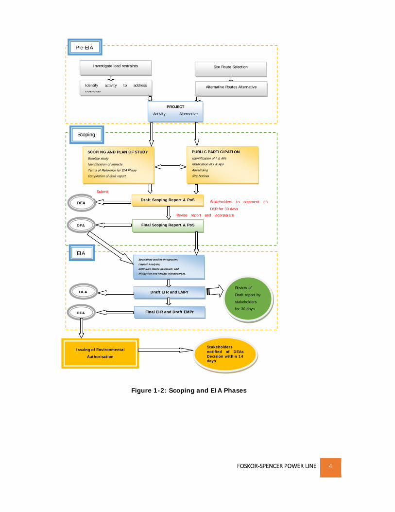
1.3 BACKGROUND TO EIA STUDY ........................................................................................................................... 3

1.3.1 SCREENING PHASE ..............................................................................................................................................5

1.3.2 SCOPING AND ENVIRONMENTAL IMPACT ASSESSMENT PHASE FOR THE PREVIOUS APPLICATION ..........................................5

1.3.3 ENVIRONMENTAL IMPACT PHASE ...........................................................................................................................7

1.4 STRUCTURE AND CONTENT OF THE ENVIRONMENTAL IMPACT ASSESSMENT REPORT ...................................................... 8

1.4.1 STRUCTURE OF THE REPORT ..................................................................................................................................8

1.4.2 CONTENT OF THE ENVIRONMENTAL IMPACT ASSESSMENT REPORT (EIAR) .....................................................................9

1.5 ASSUMPTIONS AND LIMITATIONS .................................................................................................................... 13

2. ADMINISTRATIVE, LEGAL AND POLICY REQUIREMENTS ............................................................................ 15

2.1 THE CONSTITUTION OF THE REPUBLIC OF SOUTH AFRICA ....................................................................................... 15

2.2 NATIONAL ENVIRONMENTAL MANAGEMENT ACT (ACT NO. 107 OF 1998) .............................................................. 16

2.2.1 ENVIRONMENTAL IMPACT ASSESSMENT (EIA) REGULATIONS ....................................................................................16

2.3 OTHER RELEVANT LEGISLATION ....................................................................................................................... 18

3. PROJECT DESCRIPTION .............................................................................................................................. 27

3.1 NEED AND DESIRABILITY ................................................................................................................................ 27

3.1.1 ESKOM’S MANDATE ..........................................................................................................................................27

3.1.2 TRANSMISSION SYSTEM .....................................................................................................................................27

3.2 PROJECT ACTIVITIES ...................................................................................................................................... 30

3.3 LOCATION .................................................................................................................................................. 31

3.3.1 REGIONAL CONTEXT OF THE PROJECT ....................................................................................................................31

3.3.2 SUBSTATION LOCATIONS ....................................................................................................................................32

3.3.3 LAND OWNERSHIP ............................................................................................................................................33

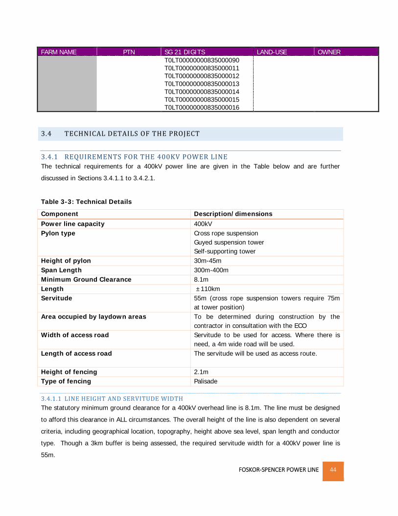
3.4 TECHNICAL DETAILS OF THE PROJECT ................................................................................................................ 44

3.4.1 REQUIREMENTS FOR THE 400KV POWER LINE ........................................................................................................44

3.4.2 POWER LINE INFRASTRUCTURE ............................................................................................................................45

3.4.3 ELECTRIC AND MAGNETIC FIELDS (EMF) ...............................................................................................................47

3.4.4 OVERHEAD LINE CORONA, NOISE AND CORONA DISCHARGE .....................................................................................48

3.5 PRE-CONSTRUCTION AND CONSTRUCTION PHASE ................................................................................................ 48

FOSKOR-SPENCER POWER LINE xxi

3.5.1 PRE-CONSTRUCTION .........................................................................................................................................48

3.5.2 CONSTRUCTION PHASE ......................................................................................................................................49

3.5.3 SUBSTATION CONSTRUCTION ..............................................................................................................................52

3.6 BULK SERVICES AND INFRASTRUCTURE .............................................................................................................. 53

3.6.1 WATER ...........................................................................................................................................................53

3.6.2 SEWERAGE ......................................................................................................................................................53

3.6.3 STORM WATER .................................................................................................................................................53

3.6.4 SOLID WASTE ...................................................................................................................................................53

3.7 OPERATION AND MAINTENANCE OF THE POWER LINE........................................................................................... 53

3.7.1 LAND USE AND POWER LINE OPERATION ...............................................................................................................54

3.8 DECOMMISSIONING PHASE ............................................................................................................................ 54

4. ALTERNATIVES .......................................................................................................................................... 56

4.1 LOCATION ALTERNATIVES .............................................................................................................................. 56

4.1.1 ROUTE/ CORRIDOR SELECTION CRITERIA ...............................................................................................................56

4.1.2 POWER LINE CORRIDOR 1 ...................................................................................................................................59

4.1.3 POWER LINE CORRIDOR ALTERNATIVE 2 ................................................................................................................60

4.1.4 FOSKOR-SPENCER DEVIATION 1A (CORRIDOR 1 AND 2) ...........................................................................................63

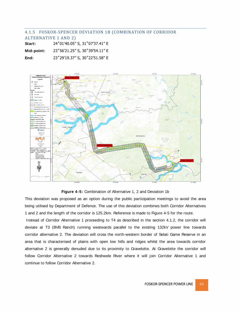
4.1.5 FOSKOR-SPENCER DEVIATION 1B (COMBINATION OF CORRIDOR ALTERNATIVE 1 AND 2) ................................................64

4.1.6 PREFERRED CORRIDOR SELECTION ........................................................................................................................65

4.1.7 SUBSTATION EXTENSION ....................................................................................................................................71

4.1.8 NO-GO ACTION ALTERNATIVES ...........................................................................................................................71

4.1.9 ACCESS ROUTES ...............................................................................................................................................72

4.2 ACTIVITY ALTERNATIVES ................................................................................................................................ 72

4.3 SCHEDULING ALTERNATIVES ........................................................................................................................... 75

4.4 ADVANTAGES AND DISADVANTAGES OF THE PROPOSED PROJECT ............................................................................ 75

5. THE RECEIVING ENVIRONMENT ................................................................................................................ 77

5.1 CLIMATE .................................................................................................................................................... 77

5.2 SOILS ........................................................................................................................................................ 78

5.3 SURFACE WATER RESOURCES ......................................................................................................................... 78

5.4 GROUND WATER .......................................................................................................................................... 80

5.5 GEOLOGICAL CONDITIONS .............................................................................................................................. 80

5.5.1 LITHOSTRATIGRAPHY .............................................................................................................................................80

5.6 TOPOGRAPHY ............................................................................................................................................. 81

5.7 FLORA & FAUNA .......................................................................................................................................... 81

5.7.1 FLORA ............................................................................................................................................................81

FOSKOR-SPENCER POWER LINE xxii

5.7.2 FAUNA ............................................................................................................................................................85

5.7.3 AVI-FAUNA ......................................................................................................................................................86

5.8 CRITICAL BIODIVERSITY AREAS ........................................................................................................................ 86

5.8.1 PROTECTED AND NATURE RESERVES .....................................................................................................................88

5.9 LAND USE ................................................................................................................................................... 90

5.10 ARCHAEOLOGICAL AND PALEONTOLOGICAL ATTRIBUTES ...................................................................................... 92

5.11 VISUAL ENVIRONMENT ............................................................................................................................... 92

5.12 AIR QUALITY ............................................................................................................................................. 92

5.13 SOCIO-ECONOMIC ENVIRONMENT ................................................................................................................. 93

5.13.1 POPULATION DEMOGRAPHICS ...........................................................................................................................93

5.13.2 GENDER ........................................................................................................................................................94

5.13.3 LANGUAGE ....................................................................................................................................................94

5.13.4 LEVEL OF EDUCATION ......................................................................................................................................94

5.13.5 EMPLOYMENT PROFILE ....................................................................................................................................94

5.13.6 HOUSEHOLDS BY DWELLING TYPE ......................................................................................................................95

5.13.7 ACCESS TO SERVICES .......................................................................................................................................95

5.13.8 ECONOMIC ACTIVITY .......................................................................................................................................96

5.13.9 TOURISM ......................................................................................................................................................97

6. OVERVIEW OF SPECIALISTS SURVEY .......................................................................................................... 98

6.1 AVI-FAUNA IMPACT ASSESSMENT .................................................................................................................... 98

6.1.1 ASSUMPTIONS AND LIMITATIONS .........................................................................................................................98

6.1.2 METHODOLOGY................................................................................................................................................99

6.1.3 IMPACT ASSESSMENT ........................................................................................................................................99

6.1.4 CONCLUSIONS AND RECOMMENDATIONS ........................................................................................................... 100

6.2 BIODIVERSITY IMPACT ASSESSMENT ..................................................................................................... 102

6.2.1 ASSUMPTIONS AND LIMITATIONS ............................................................................................................ 102

6.2.2 METHODOLOGY ........................................................................................................................................ 102

6.2.3 SUMMARY OF ASSESSMENT ............................................................................................................................. 103

6.2.4 CONCLUSIONS AND RECOMMENDATION ............................................................................................................. 105

6.3 ECO-TOURISM IMPACT ASSESSMENT .................................................................................................... 106

6.3.1 ASSUMPTIONS AND LIMITATIONS ............................................................................................................ 106

6.3.2 METHODOLOGY ........................................................................................................................................ 107

6.3.3 ASSESSMENT ............................................................................................................................................. 107

6.3.4 CONCLUSIONS AND RECOMMENDATIONS ............................................................................................... 108

6.4 HERITAGE .............................................................................................................................................. 109

FOSKOR-SPENCER POWER LINE xxiii

6.4.1 ASSUMPTIONS AND LIMITATIONS ............................................................................................................ 110

6.4.2 METHODOLOGY ........................................................................................................................................ 110

6.4.3 IMPACT ASSESSMENT ............................................................................................................................... 111

6.4.4 CONCLUSION AND RECOMMENDATIONS ............................................................................................................. 112

6.5 PALEONTOLOGY .................................................................................................................................... 113

6.5.1 METHODOLOGY............................................................................................................................................. 114

6.5.2 DESKTOP STUDY ............................................................................................................................................ 114

6.5.3 RECOMMENDATIONS ...................................................................................................................................... 114

6.6 SOCIAL IMPACT ASSESSMENT ........................................................................................................................ 114

6.6.1 ASSUMPTIONS AND LIMITATIONS ...................................................................................................................... 114

6.6.2 METHODOLOGY............................................................................................................................................. 115

6.6.3 ASSESSMENT ................................................................................................................................................. 115

6.6.4 CONCLUSION AND RECOMMENDATIONS ............................................................................................................. 116

6.7 SOIL AND LAND CAPABILITY ASSESSMENT ............................................................................................. 117

6.7.1 ASSUMPTIONS AND LIMITATIONS ...................................................................................................................... 117

6.7.2 METHODOLOGY............................................................................................................................................. 117

6.7.3 ASSESSMENT ................................................................................................................................................. 118

6.7.4 CONCLUSION AND RECOMMENDATIONS ............................................................................................................. 119

6.8 VISUAL IMPACT ASSESSMENT................................................................................................................ 120

6.8.1 ASSUMPTIONS AND LIMITATIONS ...................................................................................................................... 121

6.8.2 METHODOLOGY............................................................................................................................................. 121

6.8.3 ASSESSMENT ................................................................................................................................................. 121

6.8.4 CONCLUSION AND RECOMMENDATIONS ............................................................................................................. 123

6.9 WETLAND ASSESSMENT ........................................................................................................................ 125

6.9.1 ASSUMPTIONS AND LIMITATIONS ...................................................................................................................... 125

6.9.2 METHODOLOGY............................................................................................................................................. 126

6.9.3 ASSESSMENT ................................................................................................................................................. 126

6.9.4 CONCLUSION AND RECOMMENDATIONS ............................................................................................................ 127

6.10 COMPARISON OF ALTERNATIVES ......................................................................................................... 127

7 PUBLIC PARTICIPATION PROCESS ............................................................................................................. 129

7.1 INTRODUCTION .......................................................................................................................................... 129

7.2 OBJECTIVES AND APPROACH TO THE PPP ........................................................................................................ 129

7.3 PUBLIC PARTICIPATION TEAM ....................................................................................................................... 130

7.4 LIMITATIONS ASSOCIATED WITH PUBLIC PARTICIPATION PROCESS ......................................................................... 131

7.5 METHODOLOGY ADOPTED ........................................................................................................................... 131

FOSKOR-SPENCER POWER LINE xxiv

7.6 SUMMARY OF PP ACTIVITIES UNDERTAKEN DURING THE SCOPING PHASE OF THE PREVIOUS APPLICATION ....................... 132

7.6.1 SITE RECONNAISSANCE ................................................................................................................................... 132

7.6.2 STAKEHOLDER IDENTIFICATION ......................................................................................................................... 132

7.6.3 NOTIFICATION: .............................................................................................................................................. 133

7.6.4 MEETINGS .................................................................................................................................................... 133

7.7 PUBLIC PARTICIPATION AT EIA PHASE DURING THE PREVIOUS APPLICATION............................................................. 135

7.7.1 BACKGROUND ............................................................................................................................................... 135

7.7.2 METHODOLOGY............................................................................................................................................. 135

7.7.3 COMMENTS AND RESPONSE REPORT ................................................................................................................. 137

7.8 PUBLIC PARTICPATION FOR THE NEW APPLICATION ............................................................................................. 138

7.9 CONCLUSION ............................................................................................................................................ 138

7.10 WAY FORWARD ...................................................................................................................................... 139

8 POTENTIAL IMPACTS AND DETERMINATION OF SIGNIFICANCE ................................................................ 140

8.1 CHARACTERISTICS OF ENVIRONMENTAL IMPACTS .............................................................................................. 142

8.1.1 CUMULATIVE IMPACTS .................................................................................................................................... 145

8.1.2 STATUS ........................................................................................................................................................ 145

8.1.3 SIGNIFICANCE ................................................................................................................................................ 145

8.2 DETERMINATION OF IMPACT SIGNIFICANCE ...................................................................................................... 147

8.2.1 BIODIVERSITY IMPACT ASSESSMENT .................................................................................................................. 147

8.2.2 SOIL/LAND IMPACTS ASSESSMENT .................................................................................................................... 155

8.2.3 HYDROLOGICAL IMPACTS ................................................................................................................................. 158

8.2.4 HERITAGE RESOURCES .................................................................................................................................... 161

8.2.5 VISUAL IMPACTS ............................................................................................................................................ 162

8.2.6 SOCIAL IMPACT ............................................................................................................................................. 165

8.2.7 IMPACT SUMMARY ......................................................................................................................................... 170

9. CONCLUSION ........................................................................................................................................... 172

9.1 ENVIRONMENTAL IMPACT STATEMENT ................................................................................................ 172

9.2 ENVIRONMENTAL MANAGEMENT PROGRAMME .................................................................................. 175

9.3 CONCLUSION ......................................................................................................................................... 176

REFERENCES ................................................................................................................................................... 187

FOSKOR-SPENCER POWER LINE xxv

LIST OF TABLES

Table 2-1: List of Activities for the Power line and Associated Spencer MTS works ________________________ 17

Table 2-2: Legislative Framework _______________________________________________________________ 18

Table 3-1: Load Forecasts for Limpopo CLN _______________________________________________________ 29

Table 3-2: Farm Details and ownership __________________________________________________________ 34

Table 3-3: Technical Details ___________________________________________________________________ 44

Table 4-1: Weighting and Site Scoring against Criteria ______________________________________________ 66

Table 4-2: Site Scores against Criteria ___________________________________________________________ 68

Table 4-3: Total Site Scorings for each alternatives _________________________________________________ 70

Table 4-4: Comparison between the Overhead line and the Underground cable system ___________________ 74

Table 5-1: Average Monthly minimum temperature (ºC) ____________________________________________ 77

Table 5-2: Average Annual Rainfall, 2014-2016 ___________________________________________________ 78

Table 5-3: Prominent Rivers within the Project Area ________________________________________________ 78

Table 5-4: CBA Categories ____________________________________________________________________ 87

Table 5-5: Protected and Conservation Areas within and near the Project Area __________________________ 89

Table 5-6: Population and Municipal Land Coverages ______________________________________________ 93

Table 6-1: Information of some of the archaeological/ heritage sites noted in the proposed area __________ 111

Table 6-2: Comparison of Alternatives __________________________________________________________ 127

Table 7-1: Roles and Experience of PP team _____________________________________________________ 130

Table 7-2: Summary of PP Activities ____________________________________________________________ 133

Table 7-3: Summary of Issues and Concerns Raised _______________________________________________ 137

Table 8-1: Identification of significant impacts ___________________________________________________ 140

Table 8-2: Characteristics of Environmental Impacts ______________________________________________ 142

Table 8-3: Categories for Cumulative Impact ____________________________________________________ 145

Table 8-4: Categories for the Status of the Impact ________________________________________________ 145

Table 8-5: Significance Ratings of Impacts_______________________________________________________ 146

Table 8-6: Flora Assessment __________________________________________________________________ 147

Table 8-6: Introduction and Proliferation of Alien Vegetation _______________________________________ 149

Table 8-7: Destruction of Fauna Habitat ________________________________________________________ 150

Table 8-8: Avi-fauna ________________________________________________________________________ 152

Table 8-9: Loss of Agricultural Potential ________________________________________________________ 155

Table 8-10: Soil Erosion ______________________________________________________________________ 156

Table 8-11: Loss of Riparian Vegetation ________________________________________________________ 158

Table 8-12: Sedimentation of rivers and streams _________________________________________________ 159

FOSKOR-SPENCER POWER LINE xxvi

Table 8-13: Decrease in Water Quality _________________________________________________________ 160

Table 8-14: Heritage ________________________________________________________________________ 161

Table 8-15: Landscape Character ______________________________________________________________ 162

Table 8-16: Tourism Value ___________________________________________________________________ 163

Table 8-17: Reflectivity and Glare of Structures __________________________________________________ 164

Table 8-18: Waged Labor ____________________________________________________________________ 165

Table 8-19: Capacity and skills Development _____________________________________________________ 166

Table 8-20: Gendered Division of Labor _________________________________________________________ 166

Table 8-21: Displacement and relocation of households ____________________________________________ 167

Table 8-22: Impact Summary and Significance Ratings_____________________________________________ 170

Table 9-1: Affected Farms ____________________________________________________________________ 178

TABLE OF FIGURES

Figure 1-1: Locality Map ________________________________________________________________________1

Figure 1-2: Scoping and EIA Phases _______________________________________________________________4

Figure 3-1: Electricity Provision in South Africa ____________________________________________________ 27

Figure 3-2: Transmission Network ______________________________________________________________ 28

Figure 3-3: Regional Context of Project Area ______________________________________________________ 32

Figure 3-4: Spencer Substation _________________________________________________________________ 33

Figure 3-5: Foskor Substation __________________________________________________________________ 33

Figure 3-6: Cross Rope Suspension Tower ________________________________________________________ 46

Figure 3-7: Guyed Suspension Tower ____________________________________________________________ 46

Figure 3-8: Self-Supporting Tower ______________________________________________________________ 47

Figure 3-9: Example of Construction/Storage Camp ________________________________________________ 50

Figure 3-10: Example of clearing at tower sites ____________________________________________________ 50

Figure 3-11: Example of excavated pits __________________________________________________________ 51

Figure 3-12: Laydown Areas ___________________________________________________________________ 52

Figure 4-1: Corridor Alternative 1 _______________________________________________________________ 59

Figure 4-2: Corridor Alternative 2 _______________________________________________________________ 61

Figure 4-3: The corridor will run parallel the 132kV line _____________________________________________ 62

Figure 4-4: Corridor 1 and 2 with deviation 1a ____________________________________________________ 63

Figure 4-5: Combination of Alternative 1, 2 and Deviation 1b ________________________________________ 64

Figure 4-6: Locality of Deviation 1b _____________________________________________________________ 65

Figure 4-2: Substation Layout __________________________________________________________________ 71

FOSKOR-SPENCER POWER LINE xxvii

Figure 5-1: Merekome River ___________________________________________________________________ 79

Figure 5-2: Dam near Xihoko __________________________________________________________________ 79

Figure 5-3: Olifants Water Management Area ____________________________________________________ 80

Figure 5-4: Elevation of Project Area ____________________________________________________________ 82

Figure 5-5: Vegetation types within the project area _______________________________________________ 83

Figure 5-6: Vegetation in some areas near Selati Game Reserve ______________________________________ 84

Figure 5-7: Vegetated areas near Spencer Substation ______________________________________________ 85

Figure 5-8: CBA Areas within Project Area ________________________________________________________ 88

Figure 5-9: Protected areas and nature reserves within project area ___________________________________ 90

Figure 5-10: Land cover within project area ______________________________________________________ 91

Figure 6-1: Avi-fauna Sensitivity Map __________________________________________________________ 101

Figure 6-2: Location of Archaeological and grave sites _____________________________________________ 113

Figure 7-1: Role Players in the PPP _____________________________________________________________ 131

Figure 7-2: Role Players _____________________________________________________________________ 132

Figure 9-1: Recommended Site ________________________________________________________________ 177

FOSKOR-SPENCER POWER LINE xxviii

LIST OF APPENDICES

Appendix A: EAPs’ CV

Appendix B: DEA Correspondence

Appendix B-1: DEA- Application Acknowledgement Letter

Appendix B-2: Scoping Acceptance Letter

Appendix B-3: Request for Extension

Appendix B-4 Lapsing of Time

Appendix C: Layout

Appendix C-1: Substation Layout

Appendix C-2: Oil Holding Dam Layout

Appendix C-3: MSDS Transformer Oil

Appendix C-4: Power line bend Co-ordinates

Appendix C-5: Site Photos

Appendix D: Maps

Appendix D-1: Locality Map

Appendix D-2: CBA Map

Appendix D-3: Sensitivity Map

Appendix E: Specialists Report

Appendix E-1: EMF Detailed Study

Appendix E-2: Avi-fauna Report

Appendix E-3: Biodiversity Report

Appendix E-4: Eco-Tourism Report

Appendix E-5: Heritage and Palaeontology Report

Appendix E-6: Social Impact Assessment Report

Appendix E-7: Soil and Land Capability Report

Appendix E-8: Visual Report

Appendix E-9: Wetland Delineation Report

Appendix F: Public Participation

Appendix F-1: I & AP Database

Appendix F-2: List of Landowners

Appendix F-3: Comments and Response Report

Appendix F-4: Comments

Appendix F-4A: IAP Comments at Scoping

Appendix F-4B: IAP Comments at EIA

Appendix F-4C: Stakeholder Comments at Scoping

FOSKOR-SPENCER POWER LINE xxix

Appendix F-4D: Stakeholder Comments at EIA

Appendix F-5: Newspaper Adverts

Appendix F-5A: At Inception

Appendix F-5B: At Scoping

Appendix F-5C: At EIA

Appendix F-6: Notification

Appendix F-6A: At Inception

Appendix F-6B: At Scoping

Appendix F-6C: At EIA

Appendix F-6D: Reminder to comment at Scoping

Appendix F-6E: Reminder to comment at EIAR

Appendix F-6F: Proof of delivery of DEIAR

Appendix F-6G: New application

Appendix F-7: Minutes

Appendix F-7A: Meeting invites at Scoping

Appendix F-7B: Meeting invites at EIA

Appendix F-7C: Minutes at Scoping

Appendix F-7D: Minutes at EIA

Appendix G: Draft EMPr

LIST OF ABBREVIATIONS

APNR Associated Private Nature Reserves

CARA Conservation of Agricultural Resources Act

DEA Department of Environmental Affairs

DEAT Department of Environmental Affairs and Tourism

DSR Draft Scoping Report

DWA Department of Water Affairs

DWS Department of Water and Sanitation

DME Department of Minerals and Energy

EA Environmental Authorization

EAP Environmental Assessment Practitioner

ECA Environment Conservation Act

EIA Environmental Impact Assessment

EIR Environmental Impact Report

EMPr Environmental Management Programme

FOSKOR-SPENCER POWER LINE xxx

GDP Gross Domestic Product

HA Hectares

IAP Interested and Affected Parties

IEM Integrated Environmental Management

LED Local Economic Development

MTS Main Transmission Substation

NBA National Biodiversity Assessment

NEMA National Environmental Management Act

NHRA National Heritage Resources Act

PNR Private Nature Reserve

PP Public Participation

PPP Public Participation Process

ROW Right of Way

SAHRA South African Heritage and Resources Agency

SANDF South African National Defense Forces

SANS South African National Standards

TDP Transmission Development Plan

V Voltage

WMA Water Management Area

FOSKOR-SPENCER POWER LINE xxxi

DEFINITIONS

1 Affected environment: Those parts of the socio-economic and biophysical environment

impacted on by the development.

2 Alien Vegetation: Alien vegetation is defined as undesirable plant growth which shall

include, but not be limited to; all declared category 1, 2 and 3 listed invader species as set out

in the Conservation of Agricultural Resources Act (CARA) regulations. Other vegetation

deemed to be alien shall be those plant species that show the potential to occupy in number,

any area within the defined construction area and which are declared to be undesirable.

3 Alternatives: A possible course of action, in place of another that would meet the same

purpose and need (of proposal). Alternatives can refer to any of the following but are not

limited hereto: alternative sites for development, alternative layouts or alternative designs,

alternative processes and materials. In Integrated Environmental Management, the so-called

"no action" alternative may also require investigation in certain circumstances;

4 Assessment: The process of collecting, organizing, analyzing, interpreting and communicating

data that is relevant to some decision.

5 Bio-regional plan: inform land-use planning and decision-making by a range of sectors

whose policies and decisions impact on biodiversity.

6 Conservation Areas: are areas of land not formally protected by law but informally protected

by the current owners and users; and managed at least partly for biodiversity conservation.

7 Critical Biodiversity Areas (CBA1): are areas that are

Irreplaceable;

required to meet biodiversity pattern and/or sites that are required to meet each

ecological process targets; and

natural and near-natural sites including some degraded areas.

8 Critical Biodiversity Areas (CBA2): these are:

Best design selected sites;

Areas selected to meet biodiversity pattern and/or sites that are required to meet each

ecological process targets;

Alternative sites may be available to meet targets; and

natural and near-natural sites including some degraded areas, including areas modified

by agriculture.

9 Development: The act of altering or modifying resources to obtain potential benefits.

10 Ecological Support Areas (ESA1): are areas that are natural, near natural and degraded

areas supporting CBAs by maintaining the ecological processes on which CBAs depend.

FOSKOR-SPENCER POWER LINE xxxii

11 Ecological Support Areas (ESA2): Areas with no natural habitat that is important for

supporting ecological processes.

12 Environment: The external circumstances, conditions and objects that affect the existence

and development of individual, organism or group. These circumstances include biophysical,

social, economic, historical, cultural and political aspects.

13 Environment Authorization: A written statement from the Department of Environmental

Affairs that records its approval of a planned undertaking and the conditions of such an

approval.

14 Environmental impact: The degree of change in environmental components resulting from

the effects of an activity on the environment, whether desirable or undesirable. Impacts may

be the direct consequence of an organization’s activities or may be indirectly caused by them.

15 Environmental Impact Assessment: A process of examining the environmental effects of a

proposed development.

16 Environmental issue: A concern felt by one or more parties about some existing, potential or

perceived environmental impact.

17 Environmentally Sensitive Area: An area designated in regional or local land use plans, or

by a local, regional, provincial or national government body as being sensitive to disturbance or

identified by an applicant as being sensitive for some reason.

18 Erosion: The process by which material, such as rock or soil, is worn away or removed by

wind or water.

19 Evaluation: The process of weighing information, the act of making value judgments or

ascribing values to data to reach a decision;

20 Hazardous substance: Any substance that is of risk to health and safety, property or the

environment. Hazardous substances have been classified under the SANS 10228-B-The

identification and Classification of Dangerous Goods and Substances’.

21 Heritage Site: A site that contains either archaeological artefacts, graves, buildings older than

60 years, meteorological or geological fossils, etc.

22 Indigenous Vegetation: refers to vegetation consisting of indigenous plant species occurring

naturally in an area, regardless of the level of alien infestation and where the topsoil has not

been lawfully disturbed during the preceding ten years;

23 Integrated environmental management (IEM): is a process of integrating environmental,

Socio-economic and cultural factors in decision making to promote sustainable development.

Principles underlying IEM provide for a democratic, participatory, holistic, sustainable, equitable

and accountable approach.

FOSKOR-SPENCER POWER LINE xxxiii

24 Landowner: The individual or company that owns the land through which the servitude

crosses.

25 Mitigation: the elimination, reduction or control of the adverse environmental effects of the

project, and includes restitution for any damage to the environment caused by such effects

through replacement, restoration, compensation or any other means.

26 Monitoring Programme: The program for observing the potential environmental effects of a

project, resolving specific outstanding environmental issues, and determining the action

required based on the result of these activities.

27 National protected area means-

a) a special nature reserve;

b) a national park; or

c) a nature reserve or protected environment-

(i) managed by a national organ of state; or (ii) which falls under the jurisdiction of the

Minister for any other reason.

28 Nature reserve means-

(a) an area declared, or regarded as having been declared, in terms of section 23 of the

National Environmental Management: Protected Areas Act, 2003, as a nature reserve; or

(b) an area which before or after the commencement of this Act was or is declared or

designated in terms of provincial legislation for a purpose for which that area could in terms of

section 23(2) of the National Environmental Management: Protected Areas Act, 2003, be

declared as a nature reserve.

29 No Natural Areas Remaining: are areas without intact habitat remaining.

30 Other Natural Areas: are areas that still contain natural habitat but that are not required to

meet biodiversity targets.

31 Power line: An overhead line of whatever voltage, erected for the conducting of electricity.

32 Protected Area: Protected environment means -

(a) an area declared, or regarded as having been declared, in terms of section 28 of the

National Environmental Management: Protected Areas Act, 2003, as a protected environment;

(b) an area which before or after the commencement of this Act was or is declared or

designated in terms of provincial legislation for a purpose for which that area could in terms of

section 28(2) of the National Environmental Management: Protected Areas Act, 2003, be

declared as a protected environment; or

(c) an area which was a lake area in terms of the Lake Areas Development Act, 1975 (Act No.

39 of 1975), immediately before the repeal of that Act by section 90(1) of the National

Environmental Management: Protected Areas Act, 2003,

FOSKOR-SPENCER POWER LINE xxxiv

33 Private nature reserve means privately owned land declared as a nature reserve under

section 23 of the National Environmental Management: Protected Areas Act, 2003.

34 Right of Way (ROW): The strip of land acquired for which ESKOM has obtained the rights for

construction and operation of the distribution line.

35 Scoping: The process of determining the key issues to be addressed in an environmental

assessment. The main purpose of scoping is to focus the environmental assessment on a

manageable number of important questions. Scoping should also ensure that only significant

issues and reasonable alternatives are examined;

36 Stakeholder: A stakeholder is any group or individual that may be potentially affected by a

proposed project. Stakeholders typically include elected officials, government and non-

government agencies, environmental and other special interest groups, developers, educators,

landowners and members of the public.

37 Study Area: The area within the spatial boundaries of the scope of the environmental and

socio-economic effects assessment.

38 Substation: A network of switching, interrupting and voltage-transforming apparatus for

transferring power from the electrical transmission system to the local electrical distribution

system for utilization by electrical customers.

39 Water body: Means a body containing water and includes dams and wetlands, whether

ephemeral or permanent.

40 Water course: Means any river, stream and natural drainage channel whether carrying water

or not.

FOSKOR-SPENCER POWER LINE 1

1. INTRODUCTION

1.1 INTRODUCTION

Eskom Holdings SOC Ltd (herein after referred to as Eskom) intends to construct ±110km 400kV power

line from the existing Foskor Main Transmission Substation (MTS) near Phalaborwa to the existing

Spencer MTS near Giyani within Mopani District, Limpopo Province. In addition, Spencer MTS will be

upgraded by adding a 400/132kV transformation yard and 1 x500MVA, 400/132kV transformer.

Reference is made to Figure 1-1 for locality of the project.

The proposed activities to be undertaken (together with the infrastructure to be provided) are listed as

having detrimental impacts on the environment and as such requires that an Environmental Impact

Figure 1-1: Locality Map

FOSKOR-SPENCER POWER LINE 2

Assessment be undertaken prior to the commencement of the project. Eskom has therefore appointed

DIGES Group (herein after referred to as DIGES) to lodge an application with the Department of

Environmental Affairs (DEA) for the proposed development in terms of Section 24 and 24D of the

National Environmental Management Act (Act No.107 of 1998). The EIA will be undertaken to comply

with the Environmental Impact Assessment Regulations (Government Notice R982) of December 2014

as amended on the 7th of April 2017.

1.2 DETAILS OF ENVIRONMENTAL IMPACT ASSESSMENT PRACTITIONER (EAP)

Section 13 of EIA Regulations, Government Notice No. R982 as amended clearly indicates that an

Environment Assessment Practitioner (EAP) should be independent and have expertise in conducting

Environmental Impact Assessments, including knowledge of the Act, and any guidelines that have

relevance to the proposed activity.

DIGES Group is a black owned BBB-EE consultancy company established in 2004 that offers services in

the geo-environmental sector. The company has successfully completed many Environmental Impact

Assessments for different developments.

The details for the project EAP and compiler of this report are given below as per Section 3(1)(a) of

Appendix 3 of the EIA Regulations R982 as amended.

Brenda Makanza (Pr. Sci. Nat)

- BSc (Hons) Environmental Science (NUST, 2004),

- Professional Diploma GIS (Universitat of Salzburg, 2015)

- Certificate GIS (University of Johannesburg, 2012)

A dedicated and passionate Environmentalist with valuable theoretical and experiential acumen in the areas of

environmental conservation and administration. I have 12 years’ experience gained through direct involvement in a

number of conservation initiatives. Currently a Senior Environmental Consultant of DIGES Group responsible for

leading, administrating and completing assessments on Environmental Impact Assessments, as well as overseeing

studies, interpreting technical reports and appendices regarding the same.

Declaration of Independence

DIGES Group is an independent consultant and hereby declare that it does not have any financial or

other vested interest in the undertaking of the proposed activity, other than remuneration for the

work performed in terms of the National Environmental Management Act (Act No. 107 of 1998). In

addition, remuneration for services provided by DIGES is not subjected to or based on the approval

of the proposed development by the Competent Authority.

FOSKOR-SPENCER POWER LINE 3

I leverage academic skills gained through an honours level degree in Environmental Science & Health and Post

Graduate Certificates in Integral Water Management and Geo-informatics; alongside the proficient ability to actively

and valuably participate in the development, design and implementation of environmental / conservation

management policies and consultation initiatives; thereby supporting the highest standards of Environmental

Management and Sustainable Development, in all undertakings. Reference is made to the CV attached in Appendix

A.

1.3 BACKGROUND TO EIA STUDY

An Environmental Impact Assessment (EIA) is a proactive and systematic process where both positive

and negative potential environmental impacts associated with certain activities are assessed. Every

Environmental Impact Assessment project has two objectives namely, process and content objectives.

The process objectives are to ensure that the process is open, transparent and inclusive, supplies

stakeholders with sufficient information, affords them ample opportunity to contribute and makes them

feel that their contributions are valued. The content objectives of the project are in the form of “hard”

information: facts based on scientific and technical study, statistics or technical data.

Section 24(4) of NEMA prescribes that the procedures for the investigation, assessment and

communication of the potential consequences or impacts of activities on the environment must, inter

alia, with respect to every application for environmental authorisation, ensure that the general

objectives of Integrated Environmental Management (IEM) are considered. The EIA should include an

investigation of the potential consequences or impacts of the alternatives to the activity on the

environment and assessment of the significance of those potential consequences or impacts, including

the option of not implementing the activity. Section 24(2) indicates that the Minister can publish a list

of activities that may not commence without an environmental authorization. Three listing notices,

Listing Notice 1, 2 and 3 were published in 2014 and amended on the 7th of April 2017 determine

whether a Basic Assessment (Listing Notice 1 and 3) or Scoping and Environmental Impact Assessment

(Listing Notice 2) should be undertaken. Figure 1-2 overleaf shows the tasks to be performed during

the scoping and EIA which are dictated by the Regulations published in Government Notice R982 as

amended under Sections 24 (5) and 44 of the National Environmental Management Act (Act No. 107 of

1998).

FOSKOR-SPENCER POWER LINE 4

Pre-EIA

Investigate load restraints

Identify activity to address

restraints

Site Route Selection

Alternative Routes Alternative

PROJECT

Activity, Alternative

Routes

Scoping

SCOPING AND PLAN OF STUDY

Baseline study

Identification of impacts

Terms of Reference for EIA Phase

Compilation of draft report.

PUBLIC PARTICIPATION

Identification of I & APs

Notification of I & Aps

Advertising

Site Notices

Draft Scoping Report & PoS DEA

Final Scoping Report & PoS

Stakeholders to comment on

DSR for 30 days

DEA

Revise report and incorporate

comments

Submit

Application

EIA Specialists studies integration;

Impact Analysis;

Definitive Route Selection; and

Mitigation and Impact Management.

Draft EIR and EMPr

Final EIR and Draft EMPr

Review of

Draft report by

stakeholders

for 30 days

DEA

DEA

Issuing of Environmental

Authorisation

Stakeholders

notified of DEAs Decision within 14 days

Figure 1-2: Scoping and EIA Phases

FOSKOR-SPENCER POWER LINE 5

The following phases have been undertaken for this assessment:

1.3.1 SCREENING PHASE

Screening is the first stage in the EIA process whereby the EAP and the applicant determines if an EIA

is required for the project in terms of the EIA Regulations Government Notice R982 and its associated

Listings. The screening process was carried out and it determined that based on the project activities, a

scoping and EIA process was required as the construction of the 400kV power lines is listed in Listing

Notice 2 as amended in April 2017. In addition, the substation extension/upgrade is listed in Listing

Notice 1 whilst clearing more than 300m² of indigenous vegetation in CBA areas is listed in Listing

Notice 3.

1.3.2 SCOPING AND ENVIRONMENTAL IMPACT ASSESSMENT PHASE FOR THE

PREVIOUS APPLICATION

The second stage of the EIA process is the scoping phase which entails a baseline study and

preliminary site survey to ascertain the biophysical conditions of the site and identify the anticipated

negative and positive impacts of the development in relation to the environment. This phase also

includes public and stakeholder participation. Guidance in relation to the scoping phase is provided in

Regulation 21 of the EIA Regulations, Government Notice R982 of 2014 as amended.

During the Scoping Phase of the first application (DEA Ref: 14/12/16/3/3/2/1023), the following

general stages were followed as a basis for this assessment:

a) Determination of the Current Environmental Baseline Conditions through review of

existing information as well as field surveys to establish site specific issues and sensitivity.

Literature relating to the project area was reviewed to comprehend the status quo of the

project area and its surroundings. Topographic and thematic maps outlining the project area

were also utilized. DIGES conducted several site inspections from November 2016 to February

2017. The first site inspection undertaken was sort of reconnaissance field survey where the

different alternatives were briefly assessed. During the field surveys, most of the project area

was covered with a vehicle where access routes existed. Photographs were taken to document

the existing environmental conditions on site. Reference is made to Appendix C-5 for the site

photos;

b) Determination of Policy, Legal and Administrative Framework and requirements

through identification of relevant legal documents, guidelines and planning procedures. These

FOSKOR-SPENCER POWER LINE 6

have been reviewed to ensure that necessary measures are included in the design and

implementation of the project. In particular, those measures which could have an implication

on environmental resources were identified. Reference is made to Section 2 of this report. At

project inception, the Background Information Document and newspaper adverts only indicated

that activities 14 and 27 of Listing Notice 1 and activity 9 of Listing Notice 2 were being applied

for. After numerous discussions with the biodiversity specialist, it was also concluded that

activity 12e(ii) of Listing Notice 3 as amended should also be applied for as more than 300m2

of vegetation within CBA areas would be cleared during construction. In addition, taking into

account the comments from the Department of Environmental Affairs (DEA), activity 14 of

Listing Notice 1 as amended was removed from the application as transformer oil is not

classified as a dangerous good according to SANS 10234: supplement 2008 1.00.

c) Public Participation: An active approach was taken to identify potential Interested and

Affected Parties. The proposed alternative corridors were mapped and the affected farms were

identified and an on-site survey was carried out to identify the land owners and their contact

details. Where land owners were not identified on site, Windeed and the Department of Rural

Development and Land Reform were consulted. Stakeholder Government Departments and

affected Municipalities were also contacted to get the contact details of the relevant officials.

See Appendix F-1 and F-2 for the list of stakeholders and land owners. Notification letters,

Background Information Documents (BID) and newspaper adverts were written in English

though the area is comprised of Tsonga, Northern Sotho, English and Afrikaans. All public

meetings were then carried out using the native languages of the different areas.

The project was advertised in the Mopani, Letaba, Hoedspruit, Phalaborwa Heralds and The

Citizen from the 20th to the 24th of January 2017. Public meetings were then held from the 8th

of February to the 3rd of March 2017. See Appendix F-3 for the Comments and Response

report.

The Draft Scoping Report was submitted to IAPs for review for a period of 30 days from the

15th of May 2017 to the 15th of June 2017. Focus group meetings were then conducted from

the 24th-25th of May 2017 to discuss the draft Scoping Report. Availability of the report and the

dates of the meetings were advertised in the Mopani, Letaba, Hoedspruit, Phalaborwa Heralds

and The Citizen on the 12th of May 2017. In addition, the revised scoping report referred to as

the Final Scoping Report was also submitted to the registered Interested and Affected Parties

where two public meetings were undertaken with the game reserve owners and farmers on the

22nd of August 2017 to discuss the revisions. Reference is made to Appendix F-7C for the

FOSKOR-SPENCER POWER LINE 7

minutes of the meetings. Reference is also made to Section 7 of this report for the

comprehensive details of the public participation process.

d) Acceptance: The final scoping report and Plan of Study submitted to DEA on the 22nd of

September 2017 was accepted on the 3rd of November 2017. Reference is made to DEA

acceptance letter attached in Appendix B-2.

1.3.3 ENVIRONMENTAL IMPACT PHASE

The third phase entails the undertaking of an EIA as outlined in the Plan of Study included in the Final

Scoping Report. As a means of determining the significance of the various impacts that can or may be

associated with the power line and Spencer substation upgrade, a series of assessment criteria are

used for each impact. Based on the above description of the process, the main objectives of this EIAr

are thus:

To ensure that all relevant environmental legal requirements will be met by Eskom;

To provide information on the proposed development by describing the nature and scale thereof;

To describe the affected environment;

To inform the public about the proposal and identify the main stakeholders and their concerns and

values;

To define the reasonable and practical alternatives to the proposal;

To identify the likely beneficial and detrimental consequences of the project;

To ensure that all environmental consequences are recognized early on and taken into

consideration in the design, construction, operation and maintenance of the activity; and

To determine and recommend a set of environmental conditions and appropriate actions to

mitigate any adverse effects on the physical, biological and human environment that will ensure

that the study area is developed and operated in an environmentally sound management.

This report details the impact assessment that has been carried out and it has been guided by the

following criteria:

Assessment Criteria for Impacts: As a means of determining the significance of the various

impacts that can or may be associated with the power line and substation, a series of

assessment criteria were used for each impact. These criteria included an examination of the

nature, extent, duration, intensity and probability of the impact occurring, and assessing

FOSKOR-SPENCER POWER LINE 8

whether the impact will be positive or negative for the biophysical and social environments at

the site and surrounding areas.

Environmental Sensitivity Map: An environmental sensitivity map was used to indicate the

impacts identified as a result of the proposed development.

Maximization of Positive Impacts: The philosophy followed focused on maximizing the

benefits to the local environment

Specialists Integration: DIGES collated information from all specialists and summarized it in

this report.

Identification of Mitigation Measures: The mitigatory measures recommended describe

possible actions for the reduction of the significant negative environmental impacts identified in

the assessment. The philosophy of identifying mitigation measures for negative impacts was

based on the reduction of the impact at source, the management of the impact through

monitoring and control, and the involvement of the I&APs in consideration of mitigating

measures, where appropriate.

Environmental Management Programme: Based on the information collected during the

EIA, a project specific Environmental Management Programme (EMPr) was developed. The

plan provides guidelines for the planning, construction, operation, maintenance of the proposed

development, as well as a holistic management and monitoring plan for the entire project.

Recommendations were given with regards to the responsible parties for the implementation of

the EMPr.

It should be noted that this Environmental Impact Assessment Report was subjected to a 30 day

comment period during the previous application. All comments received were incorporated into the

Comments and Response Report and where feasible in this report.

1.4 STRUCTURE AND CONTENT OF THE ENVIRONMENTAL IMPACT ASSESSMENT

REPORT

1.4.1 STRUCTURE OF THE REPORT

To address the information required as set in Appendix 3 and to present it in a clear manner, the

following structure or layout outlined below was used:

Section 1: Background – deals with background of the project including the objectives of this EIA

and the process.

FOSKOR-SPENCER POWER LINE 9

Section 2: Administrative, Legal and Policy Requirements – To facilitate the Environmental

Impact Assessment and understand the significance of the constructing and maintain the proposed

development in the area, all relevant requirements from applicable laws, and provincial and local

regulations are discussed and their relevance ascertained.

Section 3: Project description – locality, and technical details of the project, as well as need and

desirability of the project.

Section 4: The receiving environment – a summary of the environment that will be potentially

affected by the project activities.

Section 5: Public Consultation– a summary of the consultation process undertaken with

stakeholders and Interested and Affected Parties (I&AP’s), and the issues identified during this process.

Section 6: Alternatives evaluation – A description of the alternatives identified which are being

assessed.

Section 7: Overview of specialist studies- a summary of the avifauna, air quality, heritage,

ecological, tourism, soil and land capability, visual and wetland studies undertaken.

Section 8: Potential impacts and Determination of Significance – An assessment of residual socio-

economic and bio-physical impacts, expected during construction and operation of the agreed upon

route.

Section 9: Conclusions and recommendations

Section 10: References

Appendices: Appendices relating to Environmental Impact Assessment Phase are collated at the back

of the document.

1.4.2 CONTENT OF THE ENVIRONMENTAL IMPACT ASSESSMENT REPORT (EIAR)

The Environmental Impact Assessment Report was compiled as per the guidelines indicated in

Appendix 3 of the EIA Regulations, Government Notice R982 as amended. Table 1-1 summarizes the

information required and identifies where in the report the information can be found:

Table 1-1: Environmental Impact Assessment Report

Information as Required in Appendix 3 of EIA Regulations R982 as

amended

Relevant Section in

the Report

3(1) (a)(iii) details of the EAP who prepared the report; and Page i

3(1) (a) (iv) details of the expertise of the EAP, including a curriculum vitae; Section 1.2, Appendix

FOSKOR-SPENCER POWER LINE 10

Information as Required in Appendix 3 of EIA Regulations R982 as

amended

Relevant Section in

the Report

A

3(1)(b) the location of the development footprint of the activity on the

approved site as contemplated in the accepted scoping report including:

(i) the 21-digit Surveyor General code of each cadastral land parcel;

Section 3.2.3 and

Appendix D-1

(ii) where available, the physical address and farm name; Section 3.3

(iii) where the required information in items (i) and (ii) is not available, the

coordinates of the boundary of the property or properties;

N/A

3(1) (c) a plan which locates the proposed activity or activities applied for as

well as the

associated structures and infrastructure at an appropriate scale, or, if it is—

(i)a linear activity, a description and co-ordinates of the corridor in which the

proposed activity or activities is to be undertaken;

(ii) on land where the property has not been defined, the coordinates within

which

the activity is to be undertaken;

Appendix D-1

3(1) (d) a description of the proposed activity, including

(i)all listed and specified activities triggered and being applied for;

(ii) a description of the associated structures and infrastructure related to the

development;

Section 2.2.1

3(1)(e ) a description of the policy and legislative context within which the

development is located and an explanation of how the proposed development

complies with and responds to the legislation and policy context;

Section 2

3(1) (f) a motivation for the need and desirability for the proposed

development, including the need and desirability of the activity in the context

of the preferred [location] development footprint within the approved site as

contemplated in the accepted scoping report;

Section 3.1

3(1)(g) a motivation for the preferred development footprint within the

approved site as

contemplated in the accepted scoping report;

Section 4

3(1) (h)a full description of the process followed to reach the proposed

development

footprint within the approved site as contemplated in the accepted scoping

report,

including:

Section 4

(i)details of the development footprint alternatives considered;

(ii) details of the public participation process undertaken at each of the sites in

terms of regulation 41 of these Regulations, including copies of the supporting

documents and inputs;

Section 7

(iii) a summary of the issues raised by interested and affected parties, and an

indication of the manner in which the issues were incorporated, or the reasons

for not including them;

Section 7 and

Appendix F-3

(iv) the environmental attributes associated with the development footprint Section 5

FOSKOR-SPENCER POWER LINE 11

Information as Required in Appendix 3 of EIA Regulations R982 as

amended

Relevant Section in

the Report

alternatives focusing on the geographical, physical, biological, social,

economic, heritage and cultural aspects;

(v) the impacts and risks identified including the nature, significance,

consequence, extent, duration and probability of the impacts, including the

degree to which these impacts—

(aa) can be reversed;

(bb) may cause irreplaceable loss of resources; and

(cc) can be avoided, managed or mitigated.

Section 8.

(vi) the methodology used in determining and ranking the nature,

significance, consequences, extent, duration and probability of potential

environmental impacts and risks;

Section 8

(vii) positive and negative impacts that the proposed activity and alternatives

will have on the environment and on the community that may be affected

focusing on the geographical, physical, biological, social, economic, heritage

and cultural aspects;

Section 4.1.8

(viii) the possible mitigation measures that could be applied and level of

residual risk;

Section 8.2

(ix) if no alternative development [location] footprints for the activity were

investigated, the motivation for not considering such; and

Section 4.2

(x) a concluding statement indicating the location of the preferred alternative

development [location] footprint within the approved site as contemplated in

the accepted scoping report;

Section 4.1.6

3(1) (i) a full description of the process undertaken to identify, assess and

rank the impacts the activity and associated structures and infrastructure will

impose on the preferred development footprint on the approved site as

contemplated in the accepted scoping report through the life of the activity,

including—

Section 8

(i) a description of all environmental issues and risks that were identified

during the environmental impact assessment process; and

Section 8

(ii) an assessment of the significance of each issue and risk and an indication

of the extent to which the issue and risk could be avoided or addressed by the

adoption of mitigation measures;

Section 8.1

3(1) (j) an assessment of each identified potentially significant impact and

risk, including—

Section 8.2

(i) cumulative impacts; Section 8.2

(ii) the nature, significance and consequences of the impact and risk; Section 8.2

(iii) the extent and duration of the impact and risk; Section 8.2

(iv) the probability of the impact and risk occurring; Section 8.2

(v) the degree to which the impact and risk can be reversed; Section 8.2

(vi) the degree to which the impact and risk may cause irreplaceable loss of

resources; and

Section 8.2

FOSKOR-SPENCER POWER LINE 12

Information as Required in Appendix 3 of EIA Regulations R982 as

amended

Relevant Section in

the Report

(vii) the degree to which the impact and risk can be mitigated; Section 8

3(1)(k) where applicable, a summary of the findings and recommendations of

any specialist report complying with Appendix 6 to these Regulations and an

indication as to how these findings and recommendations have been included

in the final assessment report;

Section 6

3(1)(l) an environmental impact statement which contains— Section 9.1,

(i) a summary of the key findings of the environmental impact assessment:

(ii) a map at an appropriate scale which superimposes the proposed activity

and its associated structures and infrastructure on the environmental

sensitivities of the preferred development footprint on the approved site as

contemplated in the accepted scoping report indicating any areas that should

be avoided, including buffers; and

(iii) a summary of the positive and negative impacts and risks of the proposed

activity and identified alternatives;

3(1)(m) based on the assessment, and where applicable, recommendations

from specialist reports, the recording of proposed impact management

outcomes for the development for inclusion in the EMPr as well as for inclusion

as conditions of authorisation;

Section 9.1,

3(1)(n) the final proposed alternatives which respond to the impact

management measures, avoidance, and mitigation measures identified through

the assessment;

Section 9.1,

3(1)(o)any aspects which were conditional to the findings of the assessment

either by the EAP or specialist which are to be included as conditions of

authorisation;

Section 9.1,

3(1)(p) a description of any assumptions, uncertainties and gaps in

knowledge which relate to the assessment and mitigation measures proposed;

Section 1.5

3(1)(q) a reasoned opinion as to whether the proposed activity should or

should not be authorised, and if the opinion is that it should be authorised, any

conditions that should be made in respect of that authorisation;

Section 9.1

3(1)(r ) where the proposed activity does not include operational aspects, the

period for which the environmental authorisation is required and the date on

which the activity will be concluded and the post construction monitoring

requirements finalised;

3(1)(s) an undertaking under oath or affirmation by the EAP in relation to Section 9

(i) the correctness of the information provided in the reports;

(ii) the inclusion of comments and inputs from stakeholders and I&APs; Appendix F-3 and F-4

(iii) the inclusion of inputs and recommendations from the specialist reports

where relevant; and

(iv) any information provided by the EAP to interested and affected parties

and any responses by the EAP to comments or inputs made by interested or

affected parties;

Appendix F-3

3(1)(t) where applicable, details of any financial provision for the

rehabilitation, closure, and ongoing post decommissioning management of

n/a

FOSKOR-SPENCER POWER LINE 13

Information as Required in Appendix 3 of EIA Regulations R982 as

amended

Relevant Section in

the Report

negative environmental impacts;

3(1)(u) an indication of any deviation from the approved scoping report,

including the plan of study, including─

(i)any deviation from the methodology used in determining the significance of

potential environmental impacts and risks; and

n/a

(ii)a motivation for the deviation; n/a

3(1)(v) any specific information that may be required by the competent

authority; and

3(1)(w) any other matters required in terms of section 24(4)(a) and (b) of

the Act.

1.5 ASSUMPTIONS AND LIMITATIONS

The following assumptions have been made during this study:

It is assumed that the Applicant has provided adequate details with regards to the activities to

be carried out and the processes to be followed during the construction and operation phase;

This study was carried out with the information available to the EAP at the time of executing

the study, within the available timeframe and budget. The sources consulted are not

exhaustive and additional information, which might strengthen arguments or contradict

information in this report might exist;

The study team obtained its data on affected farm owners on Windeed-Deeds office and on-

site visits undertaken by Potlako. It is assumed that this information is correct and has

identified all the affected land-owners;

It is also assumed that where a land-owner has sold the property, they will notify the Public

Participation team of the change in ownership;

Some areas were not easily accessible due to private land ownership;

Information used to inform the assessment was limited to data and GIS coverage’s available at

a local, regional and national level at the time of the assessment;

The field assessment was carried out in the summer season hence it does not consider

seasonal variations;

It is assumed that the specialists’ reports are factual and give a correct indication of the

environment and how the project activities will impact on these resources;

It is also assumed that the public participation carried out is adequate and has identified all the

Interested and Affected Parties;

FOSKOR-SPENCER POWER LINE 14

An exact commencement date for the construction phase is unknown. It is assumed that

construction will commence after public participation and an Environmental Authorization has

been issued;

The exact location of construction camps and material lay down areas have not yet been

specified. It is therefore assumed that the camps will be located within the servitude and that

the camp will consist of temporary structures, ablution facilities will be portable toilets and

temporary shower facilities; and

The exact location of the towers has not yet been determined hence visibility results are based

from the anticipated alignment that may deviate from the approved route. The differences are

considered omissible.

FOSKOR-SPENCER POWER LINE 15

2. ADMINISTRATIVE, LEGAL AND POLICY REQUIREMENTS

Environmental laws are formulated for realizing sustainable development strategy, preventing adverse

impacts on the environment from implementation of plans and construction projects, and promoting

coordinative development of the economy, society and environment. Most of South Africa’s

environmental law and principles are regulated by legislation with the Constitution of the Republic of

South Africa and the National Environmental Management Act (NEMA) being the cornerstone of

environmental law. The following laws, principles and regulations have also been formulated to

promote environmental sustainability including the interaction of the living and non-living environment

which also have relevance to this project are discussed below:

2.1 THE CONSTITUTION OF THE REPUBLIC OF SOUTH AFRICA

Section 24 of the Constitution of South Africa guarantees basic human rights and provides guiding

principles for society. The environmental rights in the constitution states:

“Everyone has the right –

a) to an environment that is not harmful to their health or well-being; and

b) to have the environment protected, for the benefit of present and future generations,

through reasonable legislative and other measures that -

(i) prevent pollution and ecological degradation;

(ii) promote conservation;

(iii) Secure ecologically sustainable development and use of natural resources while

promoting justifiable economic and social development.”

Based on this section, there is need to ascertain if the construction and operation of the 400kV power

line will result in harmful social, economic and biophysical environment after mitigation measures have

been implemented.

The Bill of Rights in Chapter 2 of the Constitution entrenches the right to information, the right to

freedom of expression, the right to participate in political activity, the right to administrative justice and

fundamental science, cultural, legal, economic and environmental rights. In addition, the Constitution

requires all legislature to facilitate public involvement in the legislative and other policy processes.

Citizens have the right to engage in public initiatives and processes on an ongoing basis. On the basis

of the Bill of Rights, the public will have access to all information developed and compiled during the

Environmental Impact Assessment process.

FOSKOR-SPENCER POWER LINE 16

2.2 NATIONAL ENVIRONMENTAL MANAGEMENT ACT (ACT NO. 107 OF 1998)

The National Environmental Management Act (NEMA) aims to improve the quality of environmental

decision-making by setting out principles for environmental management that apply to all government

departments and organisations that may affect the environment. NEMA also creates a framework for

facilitating the role of civil society in environmental governance (see below).

The Principles of National Environmental Management state that - (DEAT 1998b)

Environmental management must place people and their needs at the forefront of its concern.

Development must be socially, environmentally and economically sustainable.

Environmental management must be integrated, acknowledging that all elements of the

environment are linked and interrelated.

Environmental justice must be pursued.

Equitable Services Access to environmental resources to meet basic human needs and ensure

human well-being must be pursued.

Responsibility for the environmental health and safety consequences of a project or activity must

exist throughout its life cycle.

The participation of all interested and affected parties in environmental governance must be

promoted.

Decisions must consider the interests; needs and values of all interested and affected parties.

The social, economic and environmental impacts of activities, must be considered, assessed and

evaluated, and decisions must be appropriate in the light of such consideration and assessment.

Decisions must be taken in an open and transparent manner, and Services Access to information

must be provided in accordance with the law.

The environment is held in public trust for the people, the beneficial use of which environmental

resources must serve the public interest and the environment must be protected as the people’s

common heritage.

The costs of remedying pollution, environmental degradation and consequent adverse health

effects must be paid for by those responsible for harming the environment.

Sensitive, vulnerable, highly dynamic or stressed ecosystems, such as coastal shores, estuaries,

wetlands, and similar systems require specific attention in management and planning procedures,

especially where they are subject to significant human resource usage and development pressure.

2.2.1 ENVIRONMENTAL IMPACT ASSESSMENT (EIA) REGULATIONS

The Environmental Impact Assessment Regulations emanate from Section 24 (5) and 44 of NEMA and

they set out the processes that must be followed to obtain an Environmental Authorization. Listing

FOSKOR-SPENCER POWER LINE 17

Notice 1 and Listing Notice 2 provide lists of activities that require a Basic Assessment and EIA

respectively whilst Listing Notice 3 lists activities that would require authorization if carried out in a

specified geographical area. The EIA Regulations and listings have been amended as of the 7th of April

2017. The proposed activities that Eskom intends to undertake are listed in Listing Notice 1, 2 and 3

which are detailed below:

Table 2-1: List of Activities for the Power line and Associated Spencer MTS works

Relevant

Government

Notice

Activity Description Applicability

R983

(R327)

27

The clearance of an area of 1 hectares

or more, but less than 20hectares of

indigenous vegetation.

The expansion of the

transformation yard at

Spencer substation

requires ±9 ha and more

than 1 ha of indigenous

vegetation will be cleared

during the construction

phase.

R984

(R325)

9

The development of facilities or

infrastructure for the transmission and

distribution of electricity with a

capacity of 275 kilovolts or more,

outside an urban area or industrial

complex excluding the development of

bypass infrastructure for the

transmission and distribution of

electricity.

Construction of ±110km,

400kV power line from

Foskor substation to

Spencer substation.

R985

(R324)

12e(ii) The clearance of an area of 300

square metres or more of indigenous

vegetation except where such

clearance of indigenous vegetation is

required for maintenance purposes

undertaken in accordance with a

maintenance management plan in

Limpopo within critical biodiversity

areas identified in bioregional plans

Clearing of indigenous

vegetation within the

servitude and within CBA

areas during construction

It should be noted that at project inception, the Background Information Document and newspaper

adverts only indicated that activities 14 and 27 of Listing Notice 1 and activity 9 of Listing Notice 2 were

being applied for. After numerous discussions with the biodiversity specialist, it was also concluded that

activity 12e(ii) of Listing Notice 3 as amended should also be applied for as more than 300m2 of

FOSKOR-SPENCER POWER LINE 18

vegetation within CBA areas would be cleared during construction. In addition, taking into account the

comments from the Competent Authority (DEA), activity 14 of Listing Notice 1 as amended was

removed from the application as transformer oil is not classified as a dangerous good according to

SANS 10234: supplement 2008 1.00. To verify the classification of the oil, the Material Safety Data

Sheets (MSDS) for the transformer oil used by Eskom was used. Reference is made to Appendix C-3 for

the MSDS.

The following series of IEM Guidelines were used during the entire EIA process:

DEAT (2002), Scoping, Integrated Environmental Management, Information Series 2;

DEAT (2002), Stakeholder Engagement, Integrated Environmental Management, Information

Series 3;

DEAT (2002), Specialists Studies, Integrated Environmental Management, Information Series 4;

DEAT (2002), Impact Significance, Integrated Environmental Management, Information Series

5;

DEAT (2002), Ecological Risk Assessment, Integrated Environmental Management, Information

Series 6;

DEAT (2004), Cumulative Effects Assessment, Integrated Environmental Management,

Information Series 7; and

DEAT (2004), Criteria for determining alternatives, Integrated Environmental Management,

Information Series 11.

2.3 OTHER RELEVANT LEGISLATION

In addition to the two laws indicated above, the following laws, regulations and documents in Table 2-2

also have relevance to the project:

Table 2-2: Legislative Framework

NAME OVERVIEW PERMITS/LICENSES

INTERNATIONAL

Convention of Biological Diversity

(CBD)

South Africa is a signatory to the CBD,

which requests countries to:

• Establish a system of protected areas to

conserve biodiversity;

• Develop guidelines for the selection,

establishment and management of

protected areas; and

• Promote the protection of ecosystems,

natural habitats and the maintenance of

viable populations of species.

The proposed development traverses areas

FOSKOR-SPENCER POWER LINE 19

NAME OVERVIEW PERMITS/LICENSES

that are pristine and formally and informally

designated as nature reserves. As such

there is need to ensure that detrimental and

irreversible impacts will be mitigated or

avoided.

Biosphere reserves: The Seville

Strategy and the Statutory

Framework of the World Network.

UNESCO, Paris (UNESCO, 1996)

The primary objectives of biosphere

reserves are the conservation of biological

diversity; sustainable use and fair and

equitable sharing of benefits arising from

the utilization of genetic resources (in

accordance with the Convention on

Biological Diversity). The project area is

within the Kruger to Canyon Biosphere

hence there is need to ensure that negative

impacts are avoided or reduced.

NATIONAL

Environmental Conservation Act (Act

No. 73 of 1989)

This Act was superseded by NEMA as the

primary environmental framework act. The

purpose of the Act is to provide for effective

protection and controlled utilisation of the

environment.

National Environmental

Management: Biodiversity Act (Act

No. 10 of 2004)

This Act controls the management and

conservation of South African biodiversity

within the framework of NEMA. The Act lists

species that are threatened or require

protection to ensure their survival in the

wild, while regulating the activities, which

may involve such listed threatened or

protected species and activities which may

have a potential impact on their long-term

survival. Tzaneen Sour Bushveld (SVI8)

found within the study area has been listed

as a vulnerable ecosystem as per

Government Notice 1002 of 9 December

2011 and as such there is need to mitigate

habitat fragmentation. The corridors

traverse across CBA1, CBA2, ESA1 and ESA2

environment.

A list has been published under

Section 56 (1) of critically

endangered, endangered, vulnerable

and protected species and as such a

permit is required prior to

undertaking restricted activities in

areas with the species.

National Spatial Biodiversity

Assessment, 2004

The National Spatial Biodiversity Assessment

(NSBA) classifies areas as worthy of

protection based on its biophysical

characteristics, which are ranked according

to priority levels.

National Forest Act (Act No. 84 of

1998)

This Act provides for the management,

utilisation and protection of forests through

the enforcement of permitting requirements

associated with the removal of protected

Protected and indigenous tree cutting

permits in terms of the Section 15(1)

of the Act. The protected trees that

shall not be cut are listed in Schedule

FOSKOR-SPENCER POWER LINE 20

NAME OVERVIEW PERMITS/LICENSES

tree species, as indicated in a list of

protected trees. According to the

Biodiversity Report, several protected trees

were identified and are expected within the

3km buffer zone.

A of Notice No. 1602 of 23 December

2016.

National Environmental

Management: Protected Areas Act

(Act No.57 of 2003)

The Act makes provision for the protection

and conservation of ecologically viable areas

that show the country’s biodiversity, natural

landscapes. It also takes into account the

declaration of the various categories of

protected areas and envisages a national

register of protected areas, with a simplified

classification system of Special Nature

Reserves, National Parks, Nature Reserves

and Protected Environments. In addition,

the Act brings in the concept of biological

diversity protection and ecosystem

management. Foskor substation is within

10km of Kruger National Park and sections

of the alternative corridors traverse across

formal and informal nature reserves.

National Water Act (Act No 108 of

1997)

This Act aims to provide management of the

national water resources to achieve

sustainable use of water for the benefit of

all water users. It is anticipated that some

towers will be placed within 500m of a

watercourse and as such it can result in the

alteration of the banks of a watercourse.

This activity is listed as a water use as per

Section 21 (i) of the act.

In addition, Section 19 of the Water Act

requires the owner of the facility or person

in control of land on which any activity,

process is or was performed undertaken or

any other situation exist which causes, has

caused or is likely to cause pollution of

water resources, take all reasonable

measures to prevent any such pollution from

occurring, continuing or recurring. Eskom as

the applicant shall be responsible for

ensuring that measures are taken to avoid

and minimize the pollution of water

resources during the construction and the

operation of the power line will traverse.

General Authorization is required from

the Department of Water and

Sanitation in terms of Section 39 of

NWA for water use as defined in

Section 21(c) and 21(i).

National Environmental

Management: Waste Act (Act No. 59

In terms of the Waste Act; no person may

commence, undertake or conduct a waste

management activity except in accordance

The waste produced during the

construction and operation and

storage thereof is below the minimum

FOSKOR-SPENCER POWER LINE 21

NAME OVERVIEW PERMITS/LICENSES

of 2008) with:

o The requirements or standards

determined in terms of the Waste

Act for that activity; and

o A waste management license

issued in respect of that activity, if

a license is required.

threshold specified in the listed

activities Category A, B or C.

However, the waste produced during

construction should be disposed of at

the registered municipality landfill.

The National Environmental

Management: Air Quality Act (Act

No.39 of 2004)

The main objective of the Air Quality Act

(NEMAQA) is the protection of the

environment and human health, in a

sustainable (economic, social and ecological)

development framework, through

reasonable measures of air pollution control.

Schedule of activities that require an

atmospheric emission license has

been published. The proposed power

line and substation extension are not

listed as having detrimental impacts

on air quality.

The Hazardous Substance Act (Act

No. 15 of 1973)

The Hazardous Substances Act (HAS, No. 15

of 1973) was promulgated to provide for the

control of substances which may cause

injury, ill-health or death. Substances are

defined as hazardous if their inherent nature

is: toxic, corrosive, irritant; strongly

sensitising, flammable and pressure

generating (under certain circumstances)

which may injure cause ill-health, or death

in humans.

Minimum requirements of dealing

with hazardous wastes should be

followed when dealing with hazardous

substances.

Conservation of Agricultural

Resources Act (Act No. 43 of 1983)

The Conservation of Agricultural Resources

Act ([CARA] Act 43, 1983) provides for the:

o Protection of wetlands; and

o Requires the removal of listed alien

invasive species.

This Act also requires that any declared

invader species on Eskom land must be

controlled according to their declared

invader status.

The National Heritage Resources Act

(Act No. 25 of 1999)

Section 34 (1)): No person may alter or

demolish any structure or part of a structure

which is older than 60 years without a

permit issued by the South African Heritage

Resources Agency (SAHRA), or the

responsible provincial resources authority.

Section 35 (4): No person may, without a

permit issued by the SAHRA or the

responsible heritage resources authority,

destroy or damage, excavate, alter or

remove from its original position, or collect,

any archaeological material or object.

Permits are required for any

development that may affect heritage

resources such as graves and old

buildings. The need for permits can

only be ascertained when the

Heritage specialists undertakes a final

walk-down after the project has been

authorized.

FOSKOR-SPENCER POWER LINE 22

NAME OVERVIEW PERMITS/LICENSES

Section 36 (3)No person may, without a

permit issued by SAHRA or a provincial

heritage authority, destroy, damage, alter,

exhume or remove from its original position

or otherwise disturb any grave or burial

ground older than 60 years, which is

situated outside a formal cemetery

administered by a local authority.

Tourism Act No.3 of 2014 The main objectives of the Act are:

Promotion of responsible tourism

practices;

Provision for the effective

marketing of South Africa, both

domestically and intentionally

through South African Tourism

(SAT);

Promotion of quality tourism

products and development of

sector;

Establishment of concrete

intergovernmental relations to

develop and manage tourism.

The project area is characterized of nature

and game reserves that attract tourists due

to its pristine nature. There is therefore a

need to practice best practices during the

construction and operation of the power

line.

White Paper on the Development

and Promotion of Tourism in South

Africa, 1996

The paper provides a broad framework to

guide the development, planning and

management of tourism within the country.

Some of the constraints identified that

hinder the potential economic role of the

tourism industry relate to inadequate

funding, limited community integration,

inadequate education and training, poor

environmental management, lack of

infrastructure, increased levels of crime and

a lack of national, provincial and local

tourism structures.

To ensure that the project has a minimal

impact on tourism potential, best

environmental practices will be

recommended for implementation.

Civil Aviation Act (Act No. 13 of

2009)

This Act provides for the establishment of a

stand-alone authority mandated with

controlling, promoting, regulating,

supporting, developing, enforcing and

The Obstacle Evaluation Committee

(OEC) which consists of members

from both the SA CAA and South

African Air Force (SAAF) fulfils the

FOSKOR-SPENCER POWER LINE 23

NAME OVERVIEW PERMITS/LICENSES

continuously improving levels of safety and

security throughout the civil aviation

industry. All proposed developments or

activities in South Africa that potentially

could affect civil aviation must thus be

assessed by SACAA in terms of the SA 71

CARs and South African Civil Aviation

Technical Standards (SA CATS) to ensure

aviation safety.

role of streamlining and coordinating

the assessment and approvals of

proposed developments or activities

that have the potential to affect civil

aviation, military aviation, or military

areas of interest.

National Roads Act (Act No. 93 of

1996)

The Act provides for co-operative and

coordinated strategic planning, regulation,

facilitation and law enforcement in respect

of road traffic matters by the national,

provincial and local spheres of government.

The act makes provision for regulating the

transportation of dangerous goods and

substances by road. Dangerous goods such

as fuel will be transported on regional and

local roads.

National Appeal Regulations of 2014 The purpose of these Regulations is to

regulate the procedure contemplated in

section 43(4) of NEMA relating to the

submission, processing and consideration of,

a decision on an appeal.

Promotion of Access to Information

Act (Act No. 2 of 2000)

The Act maintains and protects South

Africans' right to access any information

held by the State and/or information held by

another person that is needed to protect or

exercise any rights. Access to information

will be granted once certain requirements

have been met. The Act also recognizes that

the right of access to information may be

limited if the limitations are reasonable in an

open and democratic society.

All project information will be availed to all

registered stakeholders and Interested and

Affected Parties.

Promotion of Administrative Justice

Act (Act No.3 Of 2000)

The Promotion of Administrative Justice Act

(PAJA) aims to make the administration

effective and accountable to people for its

actions. It promotes South African citizens'

right to just administration. Section 33 of

the Constitution guarantees that

administrative action will be reasonable,

lawful and procedurally fair and it makes

FOSKOR-SPENCER POWER LINE 24

NAME OVERVIEW PERMITS/LICENSES

sure that people have the right to ask for

written reasons when administrative action

has a negative impact on them. The

Department of Environmental Affairs’

decision which details the steps undertaken

to achieve the decision shall be made

available to the public.

Occupational Health and Safety Act

85 Of 1993

The act aims to provide for the health and

safety of persons at work and for the health

and safety of persons about the use of plant

and machinery; the protection of persons

other than persons at work against hazards

to health and safety arising out of or about

the activities of persons at work. The

construction workers should be inducted

with regards to their health and safety and

also of the communities around them.

Eskom shall also ensure compliance to these

standards during the operation of the power

line and substations.

National Energy Act Of 2008 &

Electricity Regulation Act

The purpose of the act is to ensure that

diverse energy resources are available, in

sustainable quantities and at an affordable

price and to provide for integrated energy

planning, increased generation and

consumption of renewable energies,

contingency energy planning, holding of

strategic fuel stocks and carriers, provide

appropriate energy infrastructure, data on

energy demand, supply and generation and

establish institutions responsible for energy

research.

White Paper on Energy Policy 1998

The policy has five objectives for energy

sector which are:

o increased access to affordable

energy services;

o improving energy governance;

o stimulating economic development,

managing energy related

environmental impacts;

o securing diversity through diversity;

and

o The need to provide alternative

sources of energy including

renewable.

Strategic Integrated Projects The South African Government adopted an

Infrastructure Plan and from the spatial

analysis of the country’s needs carried out,

17 Strategic Integrated Projects (SIP) have

FOSKOR-SPENCER POWER LINE 25

NAME OVERVIEW PERMITS/LICENSES

been identified that cover a wide range of

economic and social infrastructure. This

project addresses one of the SIPs namely:

SIP 10: Electricity transmission

and distribution for all

Expand the transmission and

distribution network to address

historical imbalances, provide

access to electricity for all and

support economic development.

Align the 10-year transmission

plan, the services backlog, the

national broadband roll-out and the

freight rail line development to

leverage off regulatory approvals,

supply chain and project

development capacity. The

activities undertaken for the

proposed project will contribute to

SIP 10 being achieved.

Spatial Planning and Land Use

Management Act (Act No. 16 of

2013)

This act is a framework act for all spatial

planning and land-use management

legislation in South Africa. It seeks to

promote consistency and uniformity in

procedures and decision-making in this field.

The spatial and land use management of the

4 local and the district municipalities will be

taken into account when assessing the

significance of the anticipated impacts.

Subdivision of agricultural Land Act,

No. 70 of 1970 as amended

Regulates the subdivision of all agricultural

land. The purpose is to prevent the

degradation of prime agricultural land.

Sections of the corridor alternatives traverse

across commercial agricultural land and as

such are under the auspices of this act.

Provincial, Local and District Municipalities Documents

The following provincial and district plans and guidelines are applicable to the proposed project and as such the

requirements in these documents are considered in this report:

Limpopo Environmental Management Act (Act No. 7 of 2003);

Limpopo Spatial Development Plan;

Limpopo Conservation Plan;

FOSKOR-SPENCER POWER LINE 26

NAME OVERVIEW PERMITS/LICENSES

Mopani District Spatial Development Framework;

Draft Mopani District Bioregional Plan;

Integrated Development Plan (Mopani, Phalaborwa, Greater Letaba, Greater Tzaneen and Maruleng).

Eskom Standards and Guidelines

Chemical Spillage Assessment and reporting;

Waste Management;

Water Strategy;

Water Management Policy;

Vegetation management and maintenance within Eskom land servitudes and Right of Way.

FOSKOR-SPENCER POWER LINE 27

3. PROJECT DESCRIPTION

3.1 NEED AND DESIRABILITY

3.1.1 ESKOM’S MANDATE

ESKOM is mandated by the South African Government to ensure the provision of reliable and affordable

power to South Africa. Electricity provision involves the following three phases shown in Figure 3-1:

i. Generation is the process by which electricity is produced;

ii. Transmission is the transportation of electricity that has been generated in power stations via

high voltage, long distance power lines to local networks for distribution; and

iii. Distribution is the actual delivery of electricity to end consumers.

The generation and transmission of electricity constitute electricity supply and this is largely the

function of Eskom whilst the distribution function is shared between municipalities and Eskom.

Figure 3-1: Electricity Provision in South Africa

3.1.2 TRANSMISSION SYSTEM

The transmission system plays a vital role in the delivery of reliable, high quality electricity throughout

South Africa by delivering electricity in bulk to load centers and very large end-users. The Transmission

Grid is divided into seven grid boundaries that operate and maintain 275kV, 400kV and 765kV power

lines and associated transmission substations where the power lines terminate. Reference is made to

Figure 3-2 overleaf for the transmission power lines and substations within the seven grids.

FOSKOR-SPENCER POWER LINE 28

Figure 3-2: Transmission Network

3.1.2.1 LIMPOPO CUSTOMER LOAD NETWORK (POLOKWANE CLN)

As the transmission system has expanded over the years, surplus capacity available on transmission

lines always seems to be consumed as the system grows or as transmission users find more economical

ways of meeting system demands. Transmission congestion results when an electricity transmission

path cannot accommodate increased power flow. Although the reasons for congestion vary, the

common consequence is that increased power flow on a transmission path is not possible without

risking system reliability. To ensure grid capacity and integrate the generation predicted in the IRP,

Eskom compiles a 10-year Transmission Development Plan (TDP) that is modified on an annual basis to

accommodate changes in both generation and load requirements. The load profile undertaken by

FOSKOR-SPENCER POWER LINE 29

Eskom Holdings SOC Ltd in 2015 for the Limpopo Transmission Network indicated that there is an

expected growth within Limpopo CLN as shown in Table 3-1 below:

Table 3-1: Load Forecasts for Limpopo CLN

Transmission

Supply Areas

(CLNs)

Percentage

Growth

2016 2020 2025

Polokwane 3.13 1506 1556 1871

Lephalale 5.45 866 1240 1383

Phalaborwa 7.61 1889 2543 3390

Source: Transmission Development Plan 2016-2025 (Limpopo Province)

To reinforce the province’s transmission system and ensure reliable supply of electricity, several

projects have been planned which consists of extending 400kV and 275kV power lines and installation

of additional transformers at existing substations. This report will focus on one of the projects, i.e the

Limpopo East Strengthening Project.

3.1.2.2 POLOKWANE CUSTOMER LOAD NETWORK

Mining operations, residential, agricultural and industrial activities in some parts of Limpopo Province

are supplied by the Polokwane Customer Load Network (PCLN) which is comprised of 4 substations

with Spencer 275/132kV substation being one of them. Spencer substation is located approximately

37km south west of Giyani and is currently fed by 275kV power lines from Tabor and Witkop

substations located approximately 86km and 136km respectively. In addition, the substation is

equipped with 2x250MVA, 275/132kV transformers. There are 132kV power lines which link into

distribution substations within the area and that also interconnect Spencer and Foskor MTS with the

distribution substations. The load profile undertaken for the Province showed that Spencer substation

will be having a peak demand of 318MVA by 2018. Eskom Transmission Grid Planning therefore

initiated a study to investigate possible alternatives and solutions to address the transformation

constraints at Spencer MTS, as well as 275kV transmission network constraints on the network

supplying Spencer MTS supply zone. The activities identified to address these constraints entailed the

following:

iv. Construct a 400kV power line from Foskor Substation to Spencer Substation with a length of

approximately 110km.

ii. Establish 400/132kV transformation yard and install 1 x 500MVA, 400/132kV transformer at

Spencer Substation; and

v. Establish 400/275kV transformation at Foskor substation.

FOSKOR-SPENCER POWER LINE 30

A separate project to obtain the environmental authorization of the 400/275kV transformation at Foskor

substation has been completed on the 23rd of February 2018. This report will thus focus on the

proposed construction of the 400kV power line from Foskor substation to Spencer substation and the

upgrade of Spencer substation.

3.2 PROJECT ACTIVITIES

The proposed project addressed in this document, involves the construction and operation of the

following infrastructure:

±110km, 400kV power line from Foskor MTS near Phalaborwa to Spencer MTS near

Mohlabaneng village. Two alternative corridors and two deviations from these corridors have

been identified and will be assessed. Though a 400kV power line requires a 55m wide

servitude, this study will assess a 3000m wide corridor to cater for constraints which might be

posed by the location of physical features and the final engineering designs. Reference is made

to the Locality Map attached in Appendix D-1;

400/132kV transformation yard and 1 x 500MVA, 400/132kV transformer which will cater for

the proposed 400kV power line coming from Foskor MTS. This extension will require a footprint

area of ±9 ha. The layout/configuration of the extension is yet to be finalised. A preliminary

layout is attached in Appendix C-1;

A transformer oil holding dam with a capacity of 120m3. The oil dam is required to contain any

spillage from the 1 x500MVA, 400/132kV transformer and to prevent pollution to the

environment thereby ensuring compliance with Environmental Legislation. Reference is made to

the drawing in Appendix C-2.

The proposed activities are listed in Listing Notice 1, 2 and 3 as having a detrimental impact to the

environment hence require an Environmental Impact Assessment to be undertaken. The proposed

activity to be undertaken (together with the infrastructure to be provided) is listed as activity 27 of

Listing Notice 1 (Government Notice R983), 9 of Listing Notice 2 (Government Notice R984) and Listing

Notice 3 (Government Notice R985) dated 14 December 2014 as amended which reads as follows:

Listing 1

27 of R983 (as amended): The clearance of an area of 1 hectares or more, but less than

20hectares of indigenous vegetation.

FOSKOR-SPENCER POWER LINE 31

Listing 2

9 of R984 (as amended): The development of facilities or infrastructure for the transmission and

distribution of electricity with a capacity of 275 kilovolts or more, outside an urban area or industrial

complex excluding the development of bypass infrastructure for the transmission and distribution of

electricity.

Listing 3

12e(ii) of R985: The clearance of an area of 300 square metres or more of indigenous vegetation

except where such clearance of indigenous vegetation is required for maintenance purposes

undertaken in accordance with a maintenance management plan in Limpopo within critical biodiversity

areas identified in bioregional plans.

3.3 LOCATION

3.3.1 REGIONAL CONTEXT OF THE PROJECT

The proposed project is within Mopani District Municipality located in the north-eastern part of the

Limpopo Province and bordered by Ehlanzeni District Municipality in the south, Greater Sekhukhune

Applicability

According to the Draft Mopani Bioregional Plan and the Limpopo Conservation Plan v2, the

proposed power line alternatives traverses across areas that have been classified as critical

biodiversity areas, CBA1, CBA2, ESA1 and ESA2. A sum of vegetation to be removed per tower

within these areas is more than 300m2 indigenous vegetation.

Applicability

In order to fulfill its mandate and ensure the supply of adequate electricity, Eskom intends to

construct ±110km, 400kV power line from Foskor MTS to Spencer MTS traversing across areas that

are largely classified as rural.

Applicability

The extension of Spencer substation requires ±9 hectares of which more than 1 hectare of

indigenous vegetation will be cleared during the construction phase. Reference is made to the

Biodiversity Report attached in Appendix E-3.

FOSKOR-SPENCER POWER LINE 32

District Municipality in the south west, Capricon District in the west and Vhembe District in the north

west. The proposed power line alternatives will traverse across 4 local municipalities within the District

Municipality namely Maruleng, Greater Tzaneen, Greater Letaba and Ba-Phalaborwa which are

approximately 90km, 44km, 65km and 115km west of Polokwane respectively. The District can be

accessed via R71, R81, R40, R526 and various district roads. Reference is made to Figure 3-3 for the

regional context of the project:

Figure 3-3: Regional Context of Project Area

3.3.2 SUBSTATION LOCATIONS

Foskor Main Transmission Substation is located on farm Loole 31LU at the following co-ordinates:

24˚1’40.05”S, 31˚07’37.41”E within Foskor Mine which is approximately 9km south of Phalaborwa

and 12km west of Kruger National Park. Foskor substation can be accessed via R40 and R71. Spencer

substation is located 37km south west of Giyani, on farm Worcester 200LT at the following co-

ordinates: 23˚29’19.37”S, 30˚22’51.58”E and is near Mohlabaneng. The substation can be

accessed via R81 road to Giyani. Reference is made to Figure 3-4 and 3-5 overleaf for the substations:

FOSKOR-SPENCER POWER LINE 33

Figure 3-4: Spencer Substation

Figure 3-5: Foskor Substation

3.3.3 LAND OWNERSHIP

The land-use within the project area is largely comprised of nature reserves, residential, mining,

commercial and subsistence farming. The farms are in private ownership and communal land owned by

the Government and under the control of Traditional Authorities. Reference is made to Table 3-2 for

the farm details and ownership:

FOSKOR-SPENCER POWER LINE 34

Table 3-2: Farm Details and ownership

FARM NAME PTN SG 21 DIGITS LAND-USE OWNER

Morelag 5KU 0 T0KU00000000000500000 Agricultural Ba-Phalaborwa Ba Maseke CPA

Morelag 5KU 1/3 T0KU00000000000500001

T0KU00000000000500003

Agricultural Game

Farm

Banakome CPA

Morelag 5KU 2 T0KU00000000000500002 Mining Freddies Prop PTB

Pty Ltd

Grietjie 6KU 107 T0KU00000000000600107 Private Nature Reserve

Burger, Pieter Andries

Grietjie 6KU 106 T0KU00000000000600106 Private Nature

Reserve

Plast 1 Pty Ltd

Grietjie 6KU 105 T0KU00000000000600105 Private Nature

Reserve

Brown, Trevor

Anthony

Grietjie 6KU 104 T0KU00000000000600104 Private Nature Reserve

Lotter, Anita

Grietjie 6KU 118 T0KU00000000000600118 Private Nature

Reserve

Olifants River

Estate

Grietjie 6KU 96 T0KU00000000000600096 Private Nature

Reserve

Arends, Richard

Grietjie 6KU 97 T0KU00000000000600097 Private Nature Reserve

Austin, Henry Struben

Grietjie 6KU 98 T0KU00000000000600098 Private Nature

Reserve

Nieprins cc

Grietjie 6KU 95 T0KU00000000000600095 Private Nature

Reserve

Mount Shilo Safari

cc

Grietjie 6KU 94 T0KU00000000000600094 Private Nature Reserve

Mount Shilo Safari cc

Grietjie 6KU 93 T0KU00000000000600093 Private Nature

Reserve

Kruger, Johannes

Hendrik Trustees

Grietjie 6KU 81 T0KU00000000000600081 Private Nature

Reserve

De Swardt,

Guillaume

Grietjie 6KU 82 T0KU00000000000600082 Private Nature Reserve

Vroegop cc (Mupaya Lodge)

Grietjie 6KU 87 T0KU00000000000600087 Private Nature

Reserve

Phalaborwa

Hoedspruit Makelaar cc

Grietjie 6KU 86 T0KU00000000000600086 Private Nature

Reserve

Schaap, Anna

Sussanna

Grietjie 6KU 80 T0KU00000000000600080 Private Nature

Reserve

Pretorius, Joachim

Marthinus Wessel

(Antonette Hays)

Grietjie 6KU 77 T0KU00000000000600077 Private Nature

Reserve

37 Cherries-Glass

Bead Studio & Guesthouse Pty Ltd

Grietjie 6KU 78 T0KU00000000000600078 Private Nature

Reserve

Van Rooyen, Lindie

Grietjie 6KU 76 T0KU00000000000600079 Private Nature Reserve

Outbreak Beliggings 5 cc

FOSKOR-SPENCER POWER LINE 35

FARM NAME PTN SG 21 DIGITS LAND-USE OWNER

Grietjie 6KU 75 T0KU00000000000600075 Private Nature

Reserve

Ackermann, Ester

Grietjie 6KU 74 T0KU00000000000600074 Private Nature Reserve

Citadel Prop Holdings cc

Grietjie 6KU 44 T0KU00000000000600044 Private Nature

Reserve

Jankowitz,

Johannes Daniel

Grietjie 6KU 41 T0KU00000000000600041 Private Nature

Reserve

Micheleti, Guy

Robert George, Fredrick

Grietjie 6KU 40 T0KU00000000000600040 Private Nature

Reserve

Dhooge, Andries

Christiaan Lanke, Walter Marie

Paul 7KU Rem T0KU00000000000700000 Mining National

Government

Paul 7KU 1 T0KU00000000000700001 Public Service

Infrastructure

Transnet Ltd

Doreen 8KU Rem T0KU00000000000800000 Mining National Government

Doreen 8KU 1 T0KU00000000000800001 Public Service

Infrastructure

Transnet Ltd

Doreen 8KU 2 T0KU00000000000800002 Public Service

Infrastructure

Transnet Ltd

Doreen 8KU 3 T0KU00000000000800003 Public Service Infrastructure

Transnet Ltd

Rhoda 9KU 0 T0KU00000000000900000 Mining National

Government

Sheila 10LU Rem T0LU00000000001000000 Mining National

Government

Sheila 10LU 1 T0LU0000000000100001 Public Service Infrastructure

Eskom Holdings Ltd

Wegsteek 30LU Rem T0LU00000000003000000 Mining National

Government

Loole 31LU 0 T0LU00000000003100000 Mining National Government

Thankerton 144KT

2 T0KT00000000014400002 Agricultural Game Farm

Verticure cc

Thankerton

144KT

RE/3 T0KT00000000014400003 Agricultural Game

Farm

Overvaal

eiendomme Pty Ltd

Thankerton 144KT

6 T0KT00000000014400006 Public Service Infrastructure

South African National Roads

Agency Ltd

Transport 145KT 1 T0KT00000000017200001 Agricultural Game

Farm

Overvaal

Eiendomme Pty Ltd

Hoed 146KT 0 T0KT00000000014600000 Agricultural Game Farm

HL Hall & Sons Prop Pty Ltd

Lillie 148KT Rem T0KT00000000014800000 Agricultural Game

Farm

Lillie Ranch Pty Ltd

Lillie 148KT 1 T0KT00000000014800001 Agricultural Game

Farm

Scaterfield Game

Ranch Pty Ltd

FOSKOR-SPENCER POWER LINE 36

FARM NAME PTN SG 21 DIGITS LAND-USE OWNER

Lillie 148KT 2 T0KT00000000014800002 Agricultural Game

Farm

Twin City Letaba

Ranch Pty Ltd

Lillie 148KT 3 T0KT00000000014800003 Agricultural Game Farm

Royal Square Inv. 448 cc

Punt 151KT 2/3/6/7/8 T0KT00000000151000002

T0KT00000000151000003 T0KT00000000151000007

T0KT00000000151000008

Agricultural Game

Farm

Mashishimale CPA

Try 153KT (now

Amsterdam)

0 T0KU00000000153000000 Communal National

Government (Ba-

Phalaborwa Ba Maseke CPA)

Try 153KT (now

Amsterdam)

1 T0KU00000000153000001 Game Farm Jedven Plaas Cc

Magdalena 154KT 0 T0KU00000000000600086 Game Malevelyn Holding

Pty Ltd (Olifants North Game

Reserve)

Parson 155KT 43 T0KU00000000015500043 Agriculture (Vacant)

Grunert Inv Pty Ltd

Parson 155KT 44 T0KU00000000015500044 Agriculture

(Vacant)

Grunert Inv Pty Ltd

Parson 155KT 45 T0KU00000000015500045 Agriculture

(Vacant)

Grunert Inv Pty Ltd

Parson 155KT 46 T0KU00000000155000046 Agriculture (Vacant)

Grunert Inv Pty Ltd

Parson 155KT 47 T0KU00000000155000047 Agriculture

(Vacant)

Grunert Inv Pty Ltd

Parson 155KT 48 T0KU00000000015500048 Agriculture

(Vacant)

Grunert Inv Pty Ltd

Parson 155KT 49 T0KU00000000015500049 Agriculture (Vacant)

Loftell, Richard Patrick

Parson 155KT 50 T0KU00000000015500050 Agriculture

(Vacant)

Loftell, Richard

Patrick

Parson 155KT 79 T0KU00000000015500079 Agriculture (Vacant)

Loftell, Richard Patrick

Parson 155KT 80 T0KU00000000015500080 Agriculture (Vacant)

Loftell, Richard Patrick

Archie 156KT Rem T0KT00000000015600000 Lodge Baphalaborwa Ba

Maseke CPA

Excellence 157KT Rem T0KT00000000015700000 Agricultural Excellence Farm Pty Ltd

Lekkergoed 158KT

9/23/29/50 T0KT00000000015800009 T0KT00000000015800023

T0KT00000000015800029

T0KT00000000015800050

Game Limpopo Leopard Rock Nature

Reserve

Lekkergoed

158KT

15 T0KT00000000015800015 Agricultural Game

Farm

Troutwater Trust

Archie 169KT Rem/1 T0KT00000000016900000 Agricultural Game Farm

Scaterfield Game Ranch Pty Ltd

FOSKOR-SPENCER POWER LINE 37

FARM NAME PTN SG 21 DIGITS LAND-USE OWNER

Archie 169KT 1 T0KT00000000016900001 Agricultural Game

Farm

Royal Square Inv.

448 cc

Transport 172KT 0 T0KT00000000017200000 Agricultural Game Farm

Seriso 485 Pty Ltd

Worcester 200LT 0 T0LT00000000020000000 Communal Land Modjadji Traditional

Authority

Northampton

201LT

0 T0LT00000000020100000 Communal Land Modjadji Traditional

Authority

Seaphole Communal Land Modjadji Traditional Authority

Hoofpyn 269KT 3 T0KT00000000026900003 Agricultural Game

Farm

Inyaku Game Farm

Pty Ltd

Kromriviersfontein

360LT

0 T0LT00000000036000000 Communal Modjadji Traditional

Authority

Senobela 362LT 0 T0LT00000000036200000 Communal Modjadji Traditional Authority

Makuba 425LT 0 T0LT00000000042500000 Communal Modjadji Traditional

Authority

Sirulurul 427LT 1/2 T0LT000000000742700001

T0LT000000000742700001

Communal Modjadji Traditional

Authority

Radoo 682LT 0 T0LT00000000068200000 Communal Nyavana Traditional Authority

La Parisa 729 LT Rem T0KU00000000072900000 Agricultural Gubitz Boerdery Pty

Ltd

La Parisa 729LT 1 T0KU00000000072900001 Agricultural Lompies Kwekerye

Pty Ltd

Gunyula 730LT Rem T0LT00000000073000000 Agricultural Grobler, Nicolaas

Gunyula 730LT 4 T0LT00000000073000004 Agricultural Lallu Farming

Enterprises cc

Gunyula 730LT 13 T0LT00000000073000013 Agricultural Lallu Farming Enterprises cc

Gunyula 730LT 16 T0LT00000000073000016 Agricultural Malle Mathoka

Albert Mohalea

Gunyula 730LT 17 T0LT00000000073000017 Agricultural Big Rock

Construction 74 cc

Gunyula 730LT 18 T0LT00000000073000018 Agricultural GK2N Projects Trust

Gunyula 730LT 19 T0LT00000000073000019 Agricultural Last, Andre

Gunyula 730LT 20 T0LT00000000073000020 Agricultural Last, Andre

Gunyula 730LT 21 T0LT00000000073000021 Agricultural Last, Andre

Gunyula 730LT 22 T0LT00000000073000022 Agricultural Last, Andre

Gunyula 730LT 23 T0LT00000000073000023 Agricultural Last, Andre

Gunyula 730LT 24 T0LT00000000073000024 Agricultural Last, Andre

Gunyula 730LT 26 T0LT00000000073000026 Agricultural Mkhavele, Vukosi Autis

Gunyula 730LT 27 T0LT00000000073000027 Agricultural Rikhotso, Jabulani

Herold

Gunyula 730LT 28 T0LT00000000073000028 Agricultural Rikhotso, Jabulani

Herold

Gunyula 730LT 29 T0LT00000000073000029 Agricultural Alfred Mashau

FOSKOR-SPENCER POWER LINE 38

FARM NAME PTN SG 21 DIGITS LAND-USE OWNER

Gunyula 730LT 30 T0LT00000000073000030 Agricultural Alfred Mashau

Gunyula 730LT 31 T0LT00000000073000031 Agricultural Mashaba, John

Gunyula 730LT 32 T0LT00000000073000032 Agricultural Wright, Candice Rochelle

Gunyula 730LT 33 T0LT00000000073000033 Agricultural Mbuyane Frank

Jesaya

Gunyula 730LT 34 T0LT00000000073000034 Agricultural Williams, James

Ronald

Gunyula 730LT 35 T0LT00000000073000035 Agricultural Nxumalo, Mackekwa Edwell

Gunyula 730LT 36 T0LT00000000073000036 Agricultural Tshehla, Edwin

Thapedi

Gunyula 730LT 37 T0LT00000000073000037 Agricultural Manabe, Nkateko

Loraine

Gunyula 730LT 38 T0LT00000000073000038 Agricultural Tshehla, Edwin Thapedi

Gunyula 730LT 39 T0LT00000000073000039 Agricultural Mashao, Malesela

Alfred

Gunyula 730LT 40 T0LT00000000073000040 Agricultural Mkhvele, Vukosi

Autis

Gunyula 730LT 41 T0LT00000000073000041 Agricultural Fasen, Coenraad Hendrik

Gunyula 730LT 42 T0LT00000000073000042 Agricultural Risaba, Ernest

Mkansi

Gunyula 730LT 43 T0LT00000000073000043 Agricultural Risaba, Ernest

Mkansi

Gunyula 730LT 44 T0LT00000000073000044 Agricultural Smith, Coenraad Jacobus

Gunyula 730LT 45 T0LT00000000073000045 Agricultural Tshehla, Edwin

Thapedi

Gunyula 730LT 46 T0LT00000000073000046 Agricultural Jooste, Charlotte

Catharina

Gunyula 730LT 47 T0LT00000000073000047 Agricultural Bill, Godfrey Morgan

Gunyula 730LT 48 T0LT00000000073000048 Agricultural Potgieter,

Stephanus Johannes

Gunyula 730LT 49 T0LT00000000073000049 Agricultural Mbiza, Tinyiko

Nicolas

Gunyula 730LT 50 T0LT00000000073000050 Agricultural Smith, Coenraad

Jacobus

Gunyula 730LT 51 T0LT00000000073000051 Agricultural Phosa, Sanny

Gunyula 730LT 52 T0LT00000000073000052 Agricultural Phosa, Sanny

Gunyula 730LT 53 T0LT00000000073000053 Agricultural Risaba, Ernest

Mkansi

Gunyula 730LT 54 T0LT00000000073000054 Agricultural Lallu Farming Enterprises cc

Gunyula 730LT 55 T0LT00000000073000055 Agricultural Lallu Farming

Enterprises cc

Gunyula 730LT 56 T0LT00000000073000056 Agricultural Risaba, Ernest

FOSKOR-SPENCER POWER LINE 39

FARM NAME PTN SG 21 DIGITS LAND-USE OWNER

Mkansi

Gunyula 730LT 57 T0LT00000000073000057 Agricultural Risaba, Ernest

Mkansi

Gunyula 730LT 58 T0LT00000000073000058 Agricultural Risaba, Ernest

Mkansi

Gunyula 730LT 59 T0LT00000000073000059 Agricultural Erasmus, Carel Petrus Johannes

Gunyula 730LT 60 T0LT00000000073000060 Agricultural Erasmus, Carel

Petrus Johannes

Gunyula 730LT 61 T0LT00000000073000061 Agricultural Erasmus, Carel

Petrus Johannes

Gunyula 730LT 62 T0LT00000000073000062 Agricultural Erasmus, Carel Petrus Johannes

Gunyula 730LT 63 T0LT00000000073000063 Agricultural Erasmus, Carel

Petrus Johannes

Gunyula 730LT 65 T0LT00000000073000065 Agricultural Erasmus, Carel

Petrus Johannes

Gunyula 730LT 66 T0LT00000000073000066 Agricultural Erasmus, Carel Petrus Johannes

Gunyula 730LT 67 T0LT00000000073000067 Agricultural Erasmus, Carel

Petrus Johannes

Gunyula 730LT 68 T0LT00000000073000068 Agricultural Risaba, Ernest

Mkansi

Gunyula 730LT 69 T0LT00000000073000069 Agricultural Risaba, Ernest Mkansi

Gunyula 730LT 70 T0LT00000000073000070 Agricultural Risaba, Ernest

Mkansi

Gunyula 730LT 71 T0LT00000000073000071 Agricultural Risaba, Ernest

Mkansi

Gunyula 730LT 72 T0LT00000000073000072 Agricultural Risaba, Ernest Mkansi

Gunyula 730LT 73 T0LT00000000073000073 Agricultural Wolvaardt, Jurie

Francois

Henley 734LT 2 T0LT00000000073400002 Agricultural Kidson, Dina

Johanna

Henley 734LT 5 T0LT00000000073400005 Agricultural Labuschagne, Pieter Willem

Henley 734LT 7 T0LT00000000073400007 Agricultural Last, Andre

Henley 734LT 8 T0LT00000000073400008 Agricultural David Maswanganyi Family Trust

Henley 734LT 9 T0LT00000000073400009 Agricultural David Maswanganyi

Family Trust

Henley 734LT 10 T0LT00000000073400010 Agricultural Alida & Basie Jacobs Family Trust

Henley 734LT 11 T0LT00000000073400011 Agricultural Ntimbane, Gaza Edney

Henley 734LT 12 T0LT00000000073400012 Agricultural Mathebula, Mishell

Henley 734LT 13 T0LT00000000073400013 Agricultural National

Government

Henley 734LT 14 T0LT00000000073400014 Agricultural National

FOSKOR-SPENCER POWER LINE 40

FARM NAME PTN SG 21 DIGITS LAND-USE OWNER

Government

Henley 734LT 15 T0LT00000000073400015 Agricultural Dos Santos,

Antonio Sardinha

Henley 734LT 16 T0LT00000000073400016 Agricultural Zeni, Robert

Henley 734LT 17 T0LT00000000073400017 Agricultural Zeni, Robert

Henley 734LT 18 T0LT00000000073400018 Agricultural Heydenrych, Alida Cornelia

Henley 734LT 19 T0LT00000000073400019 Agricultural Alcro Trust

Henley 734LT 20 T0LT00000000073400020 Agricultural Alcro Trust

Henley 734LT 21 T0LT00000000073400021 Agricultural Alcro Trust

Henley 734LT 22 T0LT00000000073400022 Agricultural Jacques Burger

Family Trust

Henley 734LT 23 T0LT00000000073400023 Agricultural Jacques Burger Family Trust

Henley 734LT 24 T0LT00000000073400024 Agricultural Jacques Burger

Family Trust

Henley 734LT 25 T0LT00000000073400025 Agricultural Jacques Burger

Family Trust

Henley 734LT 26 T0LT00000000073400026 Agricultural Labuschagne, Saskia Jean

Henley 734LT 27 T0LT00000000073400027 Agricultural Jacques Burger

Family Trust

Henley 734LT 28 T0LT00000000073400028 Agricultural Jacques Burger

Henley 734LT 30 T0LT00000000073400030 Agricultural Strathearn Mervyn

Gerrity Dubaj

Henley 734LT 34 T0LT00000000073400034 Agricultural Van Heerden Family Trust

Henley 734LT 35 T0LT00000000073400035 Agricultural Botha, Antonie Johannes Carolus

Matuma 735LT 0/4/5/8/9

11

T0LT00000000073500000

T0LT00000000073500004 T0LT00000000073500005

T0LT00000000073500008

T0LT00000000073500009 T0LT00000000073500011

Agricultural Xcelsior Letsitele

Prop Pty Ltd

Matuma 735LT 1/2/6/10 T0LT00000000073500001

T0LT00000000073500002 T0LT00000000073500006

T0LT00000000073500010

Agricultural Matuma Sitrus

Eiendomme Pty Ltd

Matuma 735LT 3/7 T0LT00000000073500003

T0LT00000000073500007

Agricultural Dreanco Pty Ltd

Matuma 735LT 12 T0LT00000000073500012 Agricultural Merite Pakkers Pty Ltd

La Cotte 736LT Rem T0LT00000000073600000 Agricultural Xcelsior Letsitele

Prop Pty Ltd

La Cotte 736LT 1 T0LT00000000073600001 Agricultural Nouville-Lacott Pty

Ltd

La Cotte 736LT 2 T0LT00000000073600002 Agricultural R Pretorius & Kinders Pty Ltd

La Cotte 736LT 3 T0LT00000000073600003 Agricultural R Pretorius &

FOSKOR-SPENCER POWER LINE 41

FARM NAME PTN SG 21 DIGITS LAND-USE OWNER

Kinders Pty Ltd

La Cotte 736LT 4 T0LT00000000073600004 Agricultural R Pretorius &

Kinders Pty Ltd

La Cotte 736LT 5 T0LT00000000073600005 Agricultural CLB La Cotte Trust

Black Hill 740LT Rem T0LT00000000074000000 Agricultural Game

Farm

Balepye CPA

Josephine 749LT 1 T0LT00000000074900001 Agricultural Game

Farm

Piet Warren Plase

Pty Ltd

Square 750KT Rem T0LT00000000075000000 Communal Big Rock Ranch Pty Ltd

Square 750KT 1 T0LT00000000075000001 Communal Archie Beesplaas cc

Volstruis 753LT Rem/2/3 T0LT00000000075300000 T0LT00000000075300002

T0LT00000000075300003

Agricultural Game Farm

SANDF (Government of

RSA)

Chester 754LT Rem T0LT00000000075400000 Agricultural Game Farm

Farm Chester cc

Chester 754LT 1 T0LT00000000075400001 Agricultural Game

Farm

Morgenstern

Familie Trust

Chester 754LT 2 T0LT00000000075400002 Agricultural Game

Farm

Balepye CPA

Riverhead 755LT Rem T0LT00000000075500000 Agricultural Game Farm

Balepye CPA

Eden 757LT Rem/2 T0LT00000000075700000

T0LT00000000075700002

Agricultural Game

Farm

Balapye CPA

Quagga 759LT Rem/2 T0LT00000000075900000

T0LT00000000075900002

Agricultural Game

Farm

Gravelotte Iron Ore

Company Pty Ltd

Solomons Mine 762LT

Rem/3/4 T0LT00000000076200000 T0LT00000000076200003

T0LT00000000076200004

Agricultural Game Farm

Gravelotte Iron Ore Company Pty Ltd

Free State 763LT Rem/2 T0LT00000000076300000 T0LT00000000076300002

Agricultural Game Farm

SANDF(Government of RSA)

Malati 764LT 0 T0LT00000000076400000 Agricultural Game

Farm

LE Thom Pty Ltd

Begin 765LT Rem T0LT00000000076500000 Agricultural Game

Farm

Sebakwe Trust

Begin 765LT 1 T0LT00000000076500001 Agricultural Game Farm

SANDF

Begin 765LT 3 T0LT00000000076500003 Agricultural Game

Farm

Balepye CPA

The Beacon

769LT

0 T0LT00000000076900000 Agricultural Game

Farm

Balapye CPA

Ziek 771LT 1 T0LT00000000771000001 Communal National Government

Brook 772LT Rem/1 T0LT00000000077200000

T0LT00000000077200001

Agricultural Game

Farm

Mashishimale

Traditional Council

Breakfast 773LT Rem T0LT00000000077300000 Communal Land Mashishimale CPA

Breakfast 773LT 1 T0LT00000000077300001 Agricultural Game

Farm

Majeje Traditional

Authority

Landraad 774LT Rem T0LT00000000077400000 Agricultural Game Farm

Majeje Traditional Authority

FOSKOR-SPENCER POWER LINE 42

FARM NAME PTN SG 21 DIGITS LAND-USE OWNER

Landraad 774LT 1 T0LT00000000077400000 Agricultural Game

Farm

Mashishimale CPA

Voster 775LT 1 T0LT000000000775000001 Agricultural Game Farm

Selatirus Pty Ltd

Voster 775LT 3 T0LT000000000775000003 Agricultural Game

Farm

Gedeelte 3 van die

plaas Voster Pty Ltd

B.V.B Ranch

776LT

7 T0LT00000000077600007 Agricultural Game

Farm

Ryk Nagel Selati

Familie Trust

B.V.B Ranch 776LT

9 T0LT00000000077600009 Agricultural Game Ranch

Joubert Phillip Joseph

B.V.B Ranch

776LT

10 T0LT00000000077600010 Agricultural Game

Ranch

Joubert Phillip

Joseph

B.V.B Ranch

776LT

12 T0LT00000000077600012 Agricultural Game

Ranch

Lepelle Industrial &

Mining Supplies cc

B.V.B Ranch 776LT

13 T0LT00000000077600013 Agricultural Game Ranch

B.V.B Ranch

776LT

18 T0LT00000000077600018 Agricultural Game

Ranch

J & L Fourie Trust

B.V.B Ranch

776LT

19 T0LT00000000077600019 Agricultural Game

Ranch

J & L Fourie Trust

B.V.B Ranch 776LT

20 T0LT00000000077600020 Agricultural Game Ranch

Bezuidenhout Frederik Johannes

B.V.B Ranch

776LT

21 T0LT00000000077600021 Agricultural Game

Ranch

Antenna

Eiendomme Pty Ltd

B.V.B Ranch

776LT

22 T0LT00000000077600022 Agricultural Game

Ranch

Noord Transvaalse

Akediemiese Trust

B.V.B Ranch 776LT

23 T0LT00000000077600023 Agricultural Game Ranch

Antenna Eiendomme Pty Ltd

B.V.B Ranch

776LT

24 T0LT00000000077600024 Agricultural Game

Ranch

Antenna

Eiendomme Pty Ltd

B.V.B Ranch

776LT

25 T0LT00000000077600025 Agricultural Game

Ranch

Antenna

Eiendomme Pty Ltd

B.V.B Ranch 776LT

26 T0LT00000000077600026 Agricultural Game Ranch

Antenna Eiendomme Pty Ltd

B.V.B Ranch

776LT

27 T0LT00000000077600027 Agricultural Game

Ranch

Antenna

Eiendomme Pty Ltd

B.V.B Ranch

776LT

28 T0LT00000000077600028 Agricultural Game

Ranch

Antenna

Eiendomme Pty Ltd

B.V.B Ranch 776LT

29 T0LT00000000077600029 Agricultural Game Ranch

Antenna Eiendomme Pty Ltd

B.V.B Ranch

776LT

29 T0LT00000000077600030 Agricultural Game

Ranch

Antenna

Eiendomme Pty Ltd

B.V.B Ranch

776LT

31 T0LT00000000077600031 Agricultural Game

Ranch

Antenna

eiendomme pty ltd

B.V.B Ranch 776LT

32 T0LT00000000077600032 Agricultural Game Ranch

Bezuidenhout phillipus lourens

Claimland 780LT Rem/1 T0LT00000000078000000

T0LT00000000078000001

Agricultural

PP Mare Boerdery

Pty Ltd

Claimland 780LT 2 T0LT00000000078000002 Mining National

Government

FOSKOR-SPENCER POWER LINE 43

FARM NAME PTN SG 21 DIGITS LAND-USE OWNER

Claimland 780LT 4 T0LT00000000078000004 Agricultural Piet Warren Plase

Pty Ltd

Claimland 780LT 5 T0LT00000000078000005 Mining Consolidated Murchison Ltd

Farrell 781LT 1 T0LT00000000078100001 Mining Northern District

Council

Farrell 781LT Rem/5 T0LT00000000078100005 Gravelotte Town Northern District

Council

Farrell 781LT 6 T0LT00000000078100006 Agricultural Game Farm

Piet Warren Plase

Farrell 781LT 7 T0LT00000000078100007 Mining Modjadji

Manufacturing Pty Ltd

Farrell 781LT 8 T0LT00000000078100008 Agricultural Game Farm

PP Mare Boerdery Pty Ltd

Farrell 781LT 9 T0LT00000000078100009 Agricultural Game

Farm

Provincial

Government of Limpopo

Farrell 781LT 10 T0LT00000000078100010 Agricultural Game

Farm

Northern District

Council

Mon Desir 782LT Rem/1 T0LT00000000078200000

T0LT00000000078200001

Agricultural Game

Farm

Gravelotte Iron Ore

Company Pty Ltd

Mon Desir 782LT 2 T0LT00000000078200002 Agricultural Pieter Oosthuizen Landgoed Pty Ltd

Willie 787LT Rem/5 T0LT00000000078700000

T0LT00000000078700005

Agricultural Game

Farm

Dunn, Henry Brown

Willie 787LT 2 T0LT00000000078700002 Agricultural Game

Farm

Angetu Prop Pty

Ltd

Willie 787LT 3 T0LT00000000078700003 Agricultural Game Farm

Osmers, Charles Nicolaas Joubert

Willie 787LT 6 T0LT00000000078700006 Agricultural Game

Farm

Klipspringer Lodge

cc

Willie 787LT 10 T0LT00000000078700010 Agricultural Game Farm

Elphinstone, Rachel Johanna

Emmarentia

Arundel 788LT Rem T0LT00000000078800000 Agricultural Game

Farm

HL Hall & Sons

Prop Pty Ltd

Arundel 788LT 3 T0LT00000000078800003 Agricultural Game Farm

Pieter Ernst Familie Trust

Arundel 788LT 4 T0LT00000000078800004 Agricultural Game

Farm

Nyala Lodge Share

Block Pty Ltd

Arundel 788LT 7 T0LT00000000078800007 Agricultural Game

Farm

Big Five Game Co

Pty Ltd

Danie 789LT 1 T0LT00000000078900001 Agricultural Game Farm

Pedal Trading 168 Pty Ltd

Mashisimale

800LT

0 T0LT00000000080000000 Communal Land Mashisimale

Traditional Council

Croc-Ranch

835LT

0/1/2/7/9//11/13/1

4/15/16

T0LT00000000835000000

T0LT00000000835000000

T0LT00000000835000010

Communal Land Mashishimale

Traditional Council

FOSKOR-SPENCER POWER LINE 44

FARM NAME PTN SG 21 DIGITS LAND-USE OWNER

T0LT00000000835000090

T0LT00000000835000011 T0LT00000000835000012

T0LT00000000835000013

T0LT00000000835000014 T0LT00000000835000015

T0LT00000000835000016

3.4 TECHNICAL DETAILS OF THE PROJECT

3.4.1 REQUIREMENTS FOR THE 400KV POWER LINE

The technical requirements for a 400kV power line are given in the Table below and are further

discussed in Sections 3.4.1.1 to 3.4.2.1.

Table 3-3: Technical Details

Component Description/dimensions

Power line capacity 400kV

Pylon type Cross rope suspension

Guyed suspension tower

Self-supporting tower

Height of pylon 30m-45m

Span Length 300m-400m

Minimum Ground Clearance 8.1m

Length ±110km

Servitude 55m (cross rope suspension towers require 75m

at tower position)

Area occupied by laydown areas To be determined during construction by the

contractor in consultation with the ECO

Width of access road Servitude to be used for access. Where there is

need, a 4m wide road will be used.

Length of access road The servitude will be used as access route.

Height of fencing 2.1m

Type of fencing Palisade

3.4.1.1 LINE HEIGHT AND SERVITUDE WIDTH

The statutory minimum ground clearance for a 400kV overhead line is 8.1m. The line must be designed

to afford this clearance in ALL circumstances. The overall height of the line is also dependent on several

criteria, including geographical location, topography, height above sea level, span length and conductor

type. Though a 3km buffer is being assessed, the required servitude width for a 400kV power line is

55m.

FOSKOR-SPENCER POWER LINE 45

3.4.1.2 SPAN LENGTH

The span length also depends on the same criteria as line height. The distance between supports (span

length) will vary from 300 to 400m, with an average span of 350m between supports.

3.4.1.3 SERVICE ACCESS ROADS

Temporary access routes capable of accommodating construction plant, material and workers are

required for the construction of each tower and the installation of conductors. These roads with a

width of 4m are constructed within the transmission corridor/ servitude. In consultation with the land

owners, gates are installed where they intersect with roads, other property boundaries and where

access roads cross agricultural land containing livestock.

3.4.2 POWER LINE INFRASTRUCTURE

An overhead power line is comprised of tower structures and conductors with associated hardware

discussed below:

3.4.2.1 TOWER STRUCTURES AND CONDUCTORS

Transmission towers are utilized to suspend high voltage overhead power lines and each transmission

tower must be constructed to support the level imposed on it by conductors. Although the power line

towers that will be utilized for this project have not been decided, three tower structures below are

generally used for 400kV power lines.

Cross Rope Suspension Tower

The towers are supported by stays or guys to stabilize the towers. This tower is easy to assemble and

the structure requires less galvanized steel than the guyed V tower making it lighter. Forces from the

earth-wires, tower guys, and conductors are transferred only to the two mast peaks, thus eliminating

direct bending moments in the structure and resulting in cost savings in the order of 50% per tower.

The tower has an average height of 40m and requires a servitude of 55m. However, 75m is required at

tower location. See Figure 3-6 for the tower structure.

FOSKOR-SPENCER POWER LINE 46

Figure 3-6: Cross Rope Suspension Tower

Guyed Suspension Tower

The tower has one large foundation and four guys therefore four smaller foundations. They provide the

best protection from lightning impulses due to ground wire and cross arm configuration. Tower cross

bar helps with the live maintenace.The towers have an average height of 33m. See Figure 3-7:

Figure 3-7: Guyed Suspension Tower

Self-Supporting Tower

This is a typical Eskom designed self-supporting tower and utilizes a V assembly to allow for

compaction of the phases. The structure is optimized to carry 190KN glass insulators which support

FOSKOR-SPENCER POWER LINE 47

quad zebra conductors. Commonly used before the cheaper guyed and cross rope structures were

designed. Reference is made to Figure 3-8 below for the tower.

Figure 3-8: Self-Supporting Tower

3.4.3 ELECTRIC AND MAGNETIC FIELDS (EMF)

3.4.3.1 ELECTRIC FIELDS

Power line electric fields are produced by the presence of electric charges and therefore the Voltage (V)

applied to a conductor of a power line. Generally, the voltage on a system is stable and therefore the

electric field under the line remains relatively constant. Tower geometry and conductor height affects

the electric field at ground level. Electric fields decrease with an increase in distance from the

conductor and overhead power lines are designed to meet a maximum electric field level of 10 kV/m

within the servitude and directly below the line. This level falls to lower levels and must meet the level

of 5 kV/m allowed for public exposure at the servitude boundary.

3.4.3.2 MAGNETIC FIELDS

Magnetic fields are produced by the current flowing on the conductor of a power line. The current on a

system may vary depending on the load supplied by the system. As the load changes, the magnetic

field will change. Tower geometry and conductor height affects the magnetic field at ground level.

Magnetic fields decrease with an increase in distance from the conductor. Overhead power lines are

designed to meet a maximum magnetic field level of 200 µT allowed for public exposure at the

servitude boundary. Reference is made to Appendix E-1 for a detailed study carried out by Empetus

FOSKOR-SPENCER POWER LINE 48

CC and peer reviewed by Optimum Engineers with regards to the effects of EMF on humans, plants and

animals.

3.4.4 OVERHEAD LINE CORONA, NOISE AND CORONA DISCHARGE

Corona noise is found on transmission lines where higher voltages exist and it is more active during the

increased humidity conditions provided by light rain. A large number of corona discharges are caused

by water drops collecting on the conductors. In dry conditions, the conductors usually operate below

the corona inception level, and less corona sources are present. Corona noise comprises of two sound

components: one is random crackling noise and the other is hum noise of buzzing. The random sound

has a wide frequency band because the sounds caused by corona discharge occur randomly and the

corona hum noise results from the electric field surrounding the conductors. The level of operational

noise from overhead lines will vary depending upon the environmental conditions, the locality and

several other factors including the distance to ground and voltage.

3.5 PRE-CONSTRUCTION AND CONSTRUCTION PHASE

The construction phase of the project is expected to take up to 24 months with a project lifespan of 40

years or more. The main works for the construction of the 400kV power lines and substation include

the following:

3.5.1 PRE-CONSTRUCTION

3.5.1.1 LAND NEGOTIATION

400kV power lines are constructed and operated within a 55m wide that is established along the entire

length of the line. Within this servitude, Eskom Transmission have certain rights and controls that

support the safe and effective operation of the line. Eskom is responsible for the servitude negotiation

process which is undertaken after a route has been environmentally authorized by DEA and this process

must be completed with the relevant landowner before construction starts on that property. The

negotiation involves the following steps:

Once the route is confirmed, the servitude agreement will be finalized with the individual

landowners. This agreement will set out the conditions for the establishment and operation of

the servitude, exact location of the towers, access arrangements and will be site-specific as

different landowners may have different requirements;

Compensation payments are made when the servitude is registered at the Deeds office;

Once construction is complete and the land rehabilitated to the landowners satisfaction, the

landowner signs a “Final Release” certificate. Until the “Final Release” certificate has been

FOSKOR-SPENCER POWER LINE 49

signed, Eskom Transmission remains liable for the condition of the land. Once the clearance

certificate is signed, the responsibility for the line and servitude is handed over to the regional

Eskom Transmission office.

3.5.1.2 RIGHT OF WAY SURVEYING

Prior to construction of the overhead power line, a precise ground survey is carried out to determine

the ground profile along the centre of the power line route and for 27.5m on either side where the

ground profile slopes across the power line route. This is to ensure that the location selected for towers

and stays and their relationship with each other comply with the technical limits laid down for

maximum span lengths, maximum sums of adjacent spans and safe clearance to live conductors in the

final siting of pole. Further consideration is given to detailed environmental effects. Where the route of

the line passes over or near trees that could infringe safe clearances to ‘live’ conductors, the trees must

be felled or pruned prior to the construction of the line.

3.5.1.3 SOIL SAMPLING

Geotechnical investigations will be carried out at substation and tower positions to determine the type

of foundation required. The holes will be filled in after soil sampling is completed.

3.5.1.4 STRUCTURE STACKING

A survey crew will peg the substation location and the power line corridor.

3.5.2 CONSTRUCTION PHASE

The following is a process that will be adopted for the entire route, beginning at the starting point of

the new line. Each activity will follow the previous one, such that at any one point an observer will see

a chain of events, with different teams involved over time. At any one time some or all of the different

teams may be working at different points along the line. There may be days of no activity in the

process.

3.5.2.1 CONSTRUCTION CAMP

The establishment of the construction camp will involve the clearing of vegetation, fencing of camp and

the construction of workshops and store rooms as well as temporary site offices. The location is

selected by the contractor who will take into account such aspects as access to the construction site,

access to services, access to materials, etc. The contractor will then enter into an agreement with a

FOSKOR-SPENCER POWER LINE 50

landowner for the establishment of the construction camp. The site moves continuously with the

progression of the line, so the teams will perhaps travel a different distance to the site each time.

All materials are stored at the construction camp with the exception of the steel towers and concrete.

There is usually one construction camp per 100km of transmission line. It is therefore anticipated that

there will be one construction camp along the route. Reference is made to Figure 3-9:

3.5.2.2 CLEARING

The Right of Way (ROW) must be cleared to allow for construction and operation activities of

substation and power line. The land-owner and the local community will be notified prior to

construction clearing. Reference is made to Figure 3-10 below for an example of servitude clearance.

Figure 3-10: Example of clearing at tower sites

Figure 3-9: Example of Construction/Storage Camp

FOSKOR-SPENCER POWER LINE 51

3.5.2.2 ACCESS ROAD CONSTRUCTION

Where construction of a new road has been agreed, the road width shall be determined by need, such

as equipment size, and shall be no wider than 6m. The proposed servitude will also be used to access

each tower. In consultation with the land owners, gates are installed where they intersect with roads,

other property boundaries and were access roads cross agricultural land containing livestock. It should

also be noted that no bridges will be constructed as the contractor will use the existing river/stream

crossings.

3.5.2.3 FOUNDATION INSTALLATION

A work crew will excavate the foundations for the towers. See Figure 3-11. The foundation is influenced

by the terrain encountered as well as the underlying geotechnical condition. The actual size and type of

foundation to be installed will depend on the soil bearing capacity and can be excavated manually or by

using machines. The foundations will be back filled, stabilized through compaction and capped with

concrete.

Figure 3-11: Example of excavated pits

3.5.2.4 ERECTING STRUCTURES AND STRINGING CONDUCTORS

The Right of Way corridor may be used as an area for temporary storage and handling for equipment

and materials related to construction. See Figure 3-12. Steel components of structures may be

delivered and placed on the ground near foundation sites. Once foundations are in place, the following

work will be carried out:

(i) Erection of the structures within the Right of Way;

(ii) The steel components of the tower will be assembled using a crane and then lifted onto the

foundations;

FOSKOR-SPENCER POWER LINE 52

(iii) Insulators and attachment hardware will be installed and stringing sheaves attached to the

insulators; and

(iv) The conductors will be strung by attaching the conductor to a steel line and pulled through

each structure’s stringing sheaves under tension to keep the conductors well off the ground.

Figure 3-12: Laydown Areas

3.5.3 SUBSTATION CONSTRUCTION

To cater for the proposed 400kV power line, Spencer substation needs to be extended/ upgraded to

establish the 400/132kV transformation yard and the 1x500MVA, 400/132kV transformer. In addition, a

transformer oil holding dam with a capacity of 120m3 will also be constructed. The area required for

this extension is approximately ±9 hectares and the preliminary layout for the substation extension is

appended to the Report. The proposed upgrade/ extension works will entail the following activities:

Cut and fill grading;

Placement and compaction of structure fill to serve as a foundation for equipment;

Grading to maintain drainage patterns;

Installation of equipment and structure foundations;

Construction of bund walls, oil drainage pipes and oil holding dam;

Construction of formal drainage and storm-water control measures;

Installation of structures and equipment;

Connection of the new infrastructure to the existing network; and

Erect a fence around the perimeter of the substation.

FOSKOR-SPENCER POWER LINE 53

3.6 BULK SERVICES AND INFRASTRUCTURE

The supply of the following basic services forms part of the contract between Eskom and the contractor

hence the agreements will be acquired by the contractor.

3.6.1 WATER

This report has not quantified an expected volume of water required for the construction and

operational phases of this project. Should water from nearby surface water sources be required, then a

formal application for a water use license is needed. More background information and analysis on

surrounding water resources is included in the wetland report attached in Appendix E-9.

3.6.2 SEWERAGE

Sewerage generation is anticipated during the construction phase due to the presence of the workforce

contracted for the project. Consequently, the use of portable chemical toilets is suggested, which will

be serviced periodically. During the operational phase, negligible amount of sewerage will be generated

at Spencer substation for which a septic tank will be provided. However, such a mechanism requires

adequate maintenance to prevent leakages.

3.6.3 STORM WATER

Storm-water measures will be implemented to suite the terrain. The measures to be implemented are

detailed in the Environmental Management Programme attached in Appendix G.

3.6.4 SOLID WASTE

It is anticipated that solid waste will be produced mostly in the construction phase such as litter,

packaging materials such as plastics, carton boxes, paper, beverages and stockpiles. This type of waste

will not pose any threat to the proposed project and will not require a Waste Management License.

3.7 OPERATION AND MAINTENANCE OF THE POWER LINE

The management of a Transmission line servitude is dependent on the details and conditions of the

agreement between the landowner and Eskom Transmission and are therefore site-specific. These

may, therefore, vary from location to location. However, it is common that there is a dual responsibility

for the maintenance of the servitude:

FOSKOR-SPENCER POWER LINE 54

Eskom Transmission will be responsible for the tower structures, access roads, watercourse

crossings, and gates and fences relating to servitude access.

Exceptions to the above may arise where dual use is made of the access roads and gates and specific

land use limitations are set by Eskom Transmission within the servitude which directly affect the

landowner.

3.7.1 LAND USE AND POWER LINE OPERATION

Literature studies have shown that farming and associated infrastructure such as irrigation systems and

support structures can be practiced under 400kv power lines provided that all the safe working

clearances, crop height restrictions and building restrictions are properly followed. However, there is

also a need for the land-owner to have an agreement with Eskom with regards to the activities that can

be carried out underneath the servitude. Various research undertaken has also concluded that the

Electric Magnetic Field (EMF) associated with the power line has little or no impact on the farming

activities. Reference is made to Appendix B-4 for the EMF report. The following activities are generally

allowed:

Livestock grazing: Bush clearing in the servitude will have little impact on the grazing

potential of the land because most of the vegetation can be re-established under servitude.

Overhead power lines do not affect the behavior of livestock health, therefore, they can

continue to feed underneath power line once the cleared vegetation become re-vegetated; and

Overhead power lines do not affect the growth of any crops and other low-growing vegetation.

Tree height should not exceed the minimum height restriction.

3.8 DECOMMISSIONING PHASE

During the decommissioning phase, the removal of the power lines and substation will be the reversal

of the construction phase and rehabilitation of the ROW. The process of dismantling and removal of the

line includes:

Lowering the overhead conductors and earth wires to the ground and removing them from the

site and selling them as scrap;

Removing insulators and line hardware from structures at the site and disposing them at a

registered local authority waste facility;

Dismantling the towers and cutting them into pieces small enough to be handled and

transported from the site;

FOSKOR-SPENCER POWER LINE 55

Demolition of foundations and disposing the concrete at a registered landfill site; and

Backfiling and compaction of the excavation with suitable material.

FOSKOR-SPENCER POWER LINE 56

4. ALTERNATIVES

This chapter identifies and describes the alternative infrastructure options and motivation for site

selection for the proposed project. In terms of the NEMA EIA Regulations GNR982, one of the criteria

to be considered by the Competent Authority when considering an application is “any feasible and

reasonable alternatives to the activity which is the subject of the application and any feasible and

reasonable modifications or changes to the activity that may minimise harm to the environment”.

Alternatives are defined in the Regulations as “different means of meeting the general purpose and

requirements of the activity”. It is therefore necessary to provide a description of the need and

desirability of the proposed activity and any identified alternatives to the proposed activity that are

feasible and reasonable, including the advantages and disadvantages that the proposed activity or

alternatives will have on the environment and on the community, that may be affected by the activity.

The “feasibility” and “reasonability” of an alternative will therefore be measured against the general

purpose, requirements and need of the activity and how it impacts on the environment and on the

community that may be affected by the activity. It is therefore vital that the identification, investigation

and assessment of alternatives address the issues/impacts of a proposed development.

4.1 LOCATION ALTERNATIVES

‘These are considered for the entire proposal or for a component of a proposal with the latter

sometimes being considered under site layout alternatives. A distinction should also be drawn between

alternative locations that are geographically quite separate and alternative locations that are in close

proximity. Alternative locations in the same geographic area are often referred to as alternative sites.’

DEAT, 2004.

4.1.1 ROUTE/ CORRIDOR SELECTION CRITERIA

Prior to identifying the power line alternatives, the applicant undertook a desktop evaluation to assess

and note the key challenges within the proposed area. To construct and operate a 400kV power line

from Foskor MTS to Spencer MTS, Eskom identified and evaluated two corridor alternatives at a

broader scale to identify the preferred corridor. Criteria were selected from the biophysical, technical

and social aspects to ensure representation of the different project proponents. Though these two

corridors may be suitable for a transmission power line, it should be noted that they will be thoroughly

assessed in the next sections of this report. The identified corridors represent opportunities to rule in

FOSKOR-SPENCER POWER LINE 57

and out other possible transmission line corridors that require further evaluation when they are

presented to the public for discussion and input. Corridors that are not identified at this phase may still

be added later.

The three aspects considered by Eskom to identify their preferred corridor are discussed below:

4.1.1.1 BIOPHYSICAL CRITERIA

Biodiversity: The construction and maintenance of transmission line through intact

environments may result in alteration and disruption to the habitat including impacts to fauna

and avian species and an increased risk of forest fires. The avoidance of the corridor passing

through sensitive environmental resource areas such as nature reserves and intact

environments is desired hence this criterion was weighted of high significance;

Land Capability: This was considered in the context of agricultural potential, i.e. the loss of

agricultural area due to the Right of Way. This was given a moderate weighting since some

agricultural activities are allowed within the ROW if the minimum vertical and horizontal

distances set out by Eskom are kept.

River Crossings: the spanning of power lines across rivers may result in sedimentation and

water pollution hence crossing of rivers should be minimised.

Current Land-use: the intensity of the current site use and the associated value of that use

was considered especially in a conservation and agricultural context as the area is largely

comprised of game reserves and agricultural farms. This also included an indication of the

possible economic losses and the likelihood of land owner objection should the power line

traverse across their properties.

4.1.1.2 TECHNICAL CRITERIA

Existing Right of Way (ROW): The potential location of the 400kV corridor along existing

ROWs where linear uses are already established such as transmission and distribution lines,

roads and railroads is a primary routing consideration. The co- location of linear services within

existing corridors is strongly desired;

Engineering: the terrain and location of the transmission line corridor and constructability

issues must be considered for new and existing ROW since both may have a significant bearing

on cost and effects on environmental resources. Among the constructability factors considered

is the ability to avoid or minimize the location of structures along steep slopes or

embankments, in areas of rock outcroppings, or within environmentally sensitive areas such as

wetlands. This aspect was given a moderate significance.

FOSKOR-SPENCER POWER LINE 58

Length of the Corridor: The distances of the corridors between the two MTS was also

considered as longer distances imply greater capital, larger areas of surface disturbance and

greater likelihood of nature reserves, roads and river crossings.

Future expansion of Network: The future expansion of the transmission network was

considered at a regional level. The distances between the line and the future network was

considered as it would have a bearing on costs.

4.1.1.3 SOCIAL CRITERIA

Visibility: the visibility of the power line to local receptors and tourists was considered in the

context of the current visual environment and in relation to the receptors. This aspect was

weighted as being of high significance as a larger percentage of the area is in pristine

condition;

Proximity to Receptors: The proximity of the site to the nearest receptor population defined

in terms of the likely extent of impacts such as noise, visual and air quality impacts. The

proximity was estimated as the approximate distance to the closest average receptor. A single

structure was not considered as an average receptor.

Heritage: this entails the existence of archaeological objects that may be impacted by the

construction of the power lines which may result in increasing the time frame and costs of the

project.

To ascertain the preferred corridors an assessment of the identified routes was done as per Table 4-1.

Reference is made to Section 4.1.6.

FOSKOR-SPENCER POWER LINE 59

The following two alternatives with the deviations identified are discussed in the next sub-sections:

4.1.2 POWER LINE CORRIDOR 1

Start: 24˚01’40.05” S, 31˚07’37.41” E

Mid-point: 23˚51’31.28” S, 30˚44’11.68” E

End: 23˚29’19.37” S, 30˚22’51.58” E

Figure 4-1: Corridor Alternative 1

The corridor will traverse across four Local Municipalities within Mopani District Municipality namely:

Maruleng, Ba-Phalaborwa, Greater Tzaneen and Greater Letaba. Corridor alternative 1 is 112km within

a 3 000m wide corridor. Reference is made to Figure 4-1 for corridor alternative 1. For ease of

reference T1, T2, T3 and T4 will be used to refer to the turn points:

The corridor starts at Foskor Main Transmission Substation on farm Loole 31LU within Foskor

mine running in a south westerly direction parallel to the existing 275kV power line towards T1.

This area is predominantly characterized of mining activities, nature reserves and game

farming. The vegetation is mainly comprised of woodland and grassland and the capability of

the land is non-arable. According to the Limpopo Conservation Plan (LCP v2), the area is

classified as CBA1, CBA2, ESA1 and ESA2;

FOSKOR-SPENCER POWER LINE 60

At turn point T1, the corridor will swing to the north-west crossing R40/R530, Selati Game

Reserve, Tribal Lands, i.e., at the outskirts of settlements, Ga-Mashishimale and Makwareng,

Ga-Selati River and R71 to turn point T2. The area is characterized of woodland and grassland

and classified as a Critical Biodiversity Area with the following classifications: CBA1, CBA2 and

ESA1;

At turn point T2, the corridor will turn and traverse in a westerly direction crossing Molatle

River and running parallel to the existing Gravelotte-Foskor 132kV power line for 10.5km to

turn point T3. A larger section of the corridor is within a Critical Biodiversity Area (CBA1) that

has several drainage lines and is comprised of woodland and grassland;

The corridor swings to the north-west from T3 to T4 traversing across woodland, grassland,

Ndzalama Wildlife Reserve, R71 road, Molatle and Reshwele Rivers. The corridor will traverse

across Portion 1 of Begin 765LT, Remainder, Portion 1 and 2 of Volstruis 753LT, remainder and

portion 2 of Free State 763LT which is currently under the custodianship of the South African

National Defense Forces (SANDF). These farms are currently being used for training purposes

by SANDF; and

At turn point T4, the corridor will run in a north-westerly direction towards Spencer Substation

traversing across commercial agricultural holdings that are concentrated around the Greater

Letaba River and settlements practicing subsistence cultivation. The corridor will traverse

across two non-perennial and a perennial river: Lerwatlou, Merekome and Molototsi

respectively. Sections of the corridors fall within built up areas, i.e., in Xihoko, Ga-Mawa,

Senakwe, Polaseng and Ga-Moloko. The area surrounding Spencer substation is predominantly

characterized of open bushland, subsistence farming and residential areas.

4.1.3 POWER LINE CORRIDOR ALTERNATIVE 2

Start: 24˚01’40.05” S, 31˚07’37.41” E

Mid-point: 23˚56’56.52” S, 30˚38’31.67” E

End: 23˚29’19.37” S, 30˚22’51.58” E

FOSKOR-SPENCER POWER LINE 61

Figure 4-2: Corridor Alternative 2

This alternative was referred to as Alternative 3 during the initial phase of public participation.

Due to suggestions made during the meetings, the alternative is now being referred to as

alternative 2. The proposed corridor alternative traverse areas that are similar to Alternative 1

and in some sections, will follow the same route. Reference is made to Figure 4-2 for the

locality of the corridor. Corridor alternative 2 is 121km in length within a 3000m width corridor.

Where corridor alternative 1 turns at T1 to run in a northerly direction, corridor alternative 2

will continue to run parallel to the 275kV for a further 12km cutting across Balule Nature

Reserve towards P2. The area traversed is largely natural with mining occurring near the

substation;

At P1, the corridor crosses R40 cutting across Archie farm 156KT and Lillie 148KT and landing

strips located within the farm, traversing in the southern-south east border of Selati Game

Reserve. The corridor will run parallel to R526, traversing across Ga-Selati River, irregular

plains, intact vegetation and R71 towards P2. Rocky outcrops and low hills can also be

observed within the corridor;

At P2, the corridor turns in a northerly direction traversing at the outskirts of Gravelotte with

Consolidated Murchison Mine and the airport in the north east. The corridor will traverse across

FOSKOR-SPENCER POWER LINE 62

Reshwele River and intact woodland towards P3 where it joins the corridor for Alternative 1

until P4 at Ga-Moloko; and

At Ga-Moloko the corridor will swing to the north-east running parallel to an existing 132kV

power line until Spencer substation. Reference is made to Figure 4-3. This section of the

corridor will traverse at the outskirts and through villages, cultivated fields and cross the

perennial Molototsi river running parallel to its tributary.

Figure 4-3: The corridor will run parallel the 132kV line

FOSKOR-SPENCER POWER LINE 63

4.1.4 FOSKOR-SPENCER DEVIATION 1A (CORRIDOR 1 AND 2)

Start: 23˚42’13.36” S, 30˚33’04.21” E

Mid-point: 23˚36’38.60” S, 30˚30’54.98” E

End: 23˚32’19.77” S, 30˚26’22.41” E

Figure 4-4: Corridor 1 and 2 with deviation 1a

The deviation was previously referred to as alternative 2 but due to suggestions given during the

meetings, it is now referred to as a deviation from the two alternatives. To avoid some inaccessible

areas within the built up areas, deviation 1a was proposed. Reference is made to Figure 4-4 for where

deviation 1a joins either alternative 1 or 2. The deviation is 23km with a 3000m corridor starting from

corridor alternative 1 and 2 at the agricultural plots north of Groot-Letaba River and running for 5.6km

in a north-easterly direction.

This part of the deviation corridor will cross the Lerwatlou River and traverse across the open woodland

and bushland. The corridor will then swing to the north- west traversing through and at the outskirts of

villages such as Ga-Mawa, Ooghoek, Gamela, Rampede for 17km towards corridor alternatives 1 and 2.

It will also cross shrubland, cultivated fields, Merekome River and its tributaries.

FOSKOR-SPENCER POWER LINE 64

4.1.5 FOSKOR-SPENCER DEVIATION 1B (COMBINATION OF CORRIDOR

ALTERNATIVE 1 AND 2)

Start: 24˚01’40.05” S, 31˚07’37.41” E

Mid-point: 23˚56’21.25” S, 30˚39’54.11” E

End: 23˚29’19.37” S, 30˚22’51.58” E

Figure 4-5: Combination of Alternative 1, 2 and Deviation 1b

This deviation was proposed as an option during the public participation meetings to avoid the area

being utilised by Department of Defence. The use of this deviation combines both Corridor Alternatives

1 and 2 and the length of the corridor is 125.2km. Reference is made to Figure 4-5 for the route.

Instead of Corridor Alternative 1 proceeding to T4 as described in the section 4.1.2, the corridor will

deviate at T3 (BVB Ranch) running westwards parallel to the existing 132kV power line towards

corridor alternative 2. The deviation will cross the north-western border of Selati Game Reserve in an

area that is characterised of plains with open low hills and ridges whilst the area towards corridor

alternative 2 is generally denuded due to its proximity to Gravelotte. At Gravelotte the corridor will

follow Corridor Alternative 2 towards Reshwele River where it will join Corridor Alternative 1 and

continue to follow Corridor Alternative 2.

FOSKOR-SPENCER POWER LINE 65

Figure 4-6: Locality of Deviation 1b

4.1.6 PREFERRED CORRIDOR SELECTION

During the screening and scoping phase, to determine the preferred alternative with regards to the two

alternatives and factoring in the inclusion of the deviations, the criteria discussed in Section 4.1.1.1 to

4.1.1.3 were assigned weights from 1-3 in terms of environmental importance and the anticipated

impacts where 1 was assigned to criteria of low significance and 3 for a criteria with high significance.

For example, due to the pristine nature of the environment near Foskor substation and the nature

reserves, biodiversity was deemed as a highly significant criteria whilst river crossings are assigned a

weight of 1 since the impacts expected when power lines span across rivers are low. The table below

shows how the site scores and the weights were assigned for each criterion:

FOSKOR-SPENCER POWER LINE 66

Table 4-1: Weighting and Site Scoring against Criteria

Site Selection

Criteria

Site Scoring Against Criteria Weight

Low (1) Medium (2) High (3)

Bio-physical

Biodiversity Impacted Area Area of Low sensitivity Area of conservation

importance

3

Land Capability No potential Low potential for

Agriculture

Agricultural areas/high

agricultural potential

2

River Crossing No Yes 1

Current Land-Use No use Moderate use Intensively used 2

Technical

Existing ROW >40% of corridor runs

parallel existing corridor

<40% of corridor runs

parallel existing

corridor

No 1

Engineering No constraints With constraints that

can be addressed

Not suitable 2

Future Expansion of

Network

Close Proximity (Within

50km radius)

Far (>50km radius) 1

Social

Visibility Low visibility in project

area

Low visibility in natural

areas and high

visibility in project area

High visibility in natural

areas

3

Proximity to receptors Within 5000m-2500m Within 2500-500m 500m 3

Heritage - - -

To compute the total score of each corridor, the site score of each criterion was multiplied by the

criterion weighting to get a weighted site score. All weighted site scores for a corridor were added to

get the total score per corridor. The corridor with the lowest total site score was the most preferred.

Based on the above table, environmental datasets were overlaid to get the areas the power line will

traverse across. The length of the power line traversing across the different datasets or environment

was measured and expressed as a percentage of the overall power line route. For example, the length

of power line route alternative 1 traversing across nature reserves was measured and expressed as a

percentage of the total length of alternative power line 1. Table 4-2 assigns site scores based on the

percentages calculated and the implications of such on the identified criteria. The following datasets

were used to make a comparison of the alternative corridors/routes:

i. Limpopo Conservation Plan version 2. The source of data is Limpopo Department of Economic

Development Environment and Tourism;

ii. Land capability;

FOSKOR-SPENCER POWER LINE 67

iii. Protected and Conservation Areas. The source of data is DEA: South Africa Protected Areas

Database_2017_Q2; and

iv. Existing power lines. The source of data is Eskom.

It should be noted that deviation 1a was not included in the selection of the preferred route, as this

deviation has relatively the same environment with alternative 1, 2 and a combination of 1,2 and

deviation 1b and as such the implications posed by assessing the alternative are the same respectively.

FOSKOR-SPENCER POWER LINE 68

Table 4-2: Site Scores against Criteria

Site Score

Site Criteria Alternative 1 Alternative 2 Deviation 1b in combination with

Alternative 1 and 2

Biodiversity High (3) High (3) High (3)

Comments 45% of the power line route traverses

across nature reserves whilst 76%

traverses across Critical Biodiversity

areas (CBA1, CBA2, ESA1, ESA2)

48% of the power line route traverses

across nature reserves whilst 86%

traverses across Critical Biodiversity areas

(CBA1, CBA2, ESA1, ESA2)

39% of the power line route traverses

across nature reserves whilst 86%

traverses across Critical Biodiversity areas

(CBA1, CBA2, ESA1, ESA2)

Land capability Medium (2) Medium (2) Medium (2)

Comments Sections of the power line traverse

across commercial and subsistence

farms.

Sections of the power line traverse across

commercial and subsistence farms.

Sections of the power line traverse across

commercial and subsistence farms.

River Crossings Medium (2) Medium (2) Medium (2)

Comments The power line crosses several

ephemeral and perennial rivers.

However, linear projects are regarded

to have less impacts when it comes to

wetland degradation.

The power line crosses several ephemeral

and perennial rivers. However, linear

projects are regarded to have less

impacts when it comes to wetland

degradation.

The power line crosses several ephemeral

and perennial rivers. However, linear

projects are regarded to have less impacts

when it comes to wetland degradation.

Current Land-use Medium (2) High (3) Medium (2)

Comments Based on the activities carried out

within the area and surrounding

environment indicate that the power

line construction and operation will

have an impact on tourism. This will

result in objections from land owners.

Based on the activities carried out within

the area and surrounding environment

indicate that the power line construction

and operation will have an impact on

tourism. This will result in objections from

land owners. In addition, there are

landing strips within the corridor.

This alternative has the same implications

as Alternative 1 and 2. However, it avoids

the farms utilised for training activities by

the Department of Defence.

Existing Right Of

Way

Medium (2) Medium (2) Low (1)

Comments 24% of the power line route runs

parallel to the existing 132kV and

32% of the power line route runs parallel

to the existing 132kV and 275kV power

46% of the power line route runs parallel to

existing 132kV and 275kV power lines.

FOSKOR-SPENCER POWER LINE 69

275kV power lines. lines.

Engineering Low (1) Low (1) Low (1)

Comments Some sections of the route are

characterised by ridges which can be

addressed during the final power line

design.

Some sections of the route are

characterised by ridges which can be

addressed during the power line design.

Some sections of the route are

characterised by ridges which can be

addressed which can be addressed during

the power line design.

Future Expansion of

Network

Low (1) Low (1) Low (1)

Comments The power line route is within 50km

radius from Tzaneen.

The power line route is within 44km

radius from Tzaneen.

The power line route is within 50km radius

from Tzaneen.

Visibility Medium (2) High (3) Medium (2)

Comments Due to the pristine nature of most of

the project and surrounding area. The

height of the towers will render them

visible.

Due to the pristine nature of most of the

project and surrounding area. The height

of the towers will render them visible.

Due to the pristine nature of most of the

project and surrounding area. The height of

the towers will render them visible.

Proximity of

receptors

High (3) High (3) High (3)

Comments The power line will traverse across

natural areas where tourism activities

are undertaken. It will also cross within

500m of built up areas near Spencer

Substation.

The power line will traverse across natural

areas where tourism activities are

undertaken. It will also cross within 500m

of built up areas near Spencer Substation.

The power line will traverse across natural

areas where tourism activities are

undertaken. It will also cross within 500m

of built up areas near Spencer Substation.

FOSKOR-SPENCER POWER LINE 70

Table 4-3: Total Site Scorings for each alternatives

Site Selection

Criteria

Corridor Alternative 1 Corridor Alternative 2 Deviation 1b (Combination of

Corridor 1 and 2)

Weight Site Score Total Site Score Total Site Score Total

Biodiversity 3 3 9 3 9 3 9

Land Capability 2 2 4 2 4 2 4

River Crossing 1 2 2 2 2 2 2

Current Land-Use 2 2 4 3 6 2 4

Existing ROW 1 2 2 2 2 1 1

Engineering 2 1 2 1 2 1 2

Future Expansion of

Network

1 1 1 1 1 1 1

Visibility 3 2 6 3 6 2 6

Proximity to receptors 3 3 9 3 9 3 9

Heritage - - -

Total 39 41 38

Prior to the inclusion of deviation 1b, corridor alternative 1 was the preferred alternative. Assessing deviation 1b and how it would connect to

the two alternatives resulted in having a combination of alternative 1, 2 and deviation 1b as the preferred route.

FOSKOR-SPENCER POWER LINE 71

4.1.7 SUBSTATION EXTENSION

Spencer substation is located within Greater Letaba Local Municipality near Mohlabaneng at the

following co-ordinates: 23˚29’19.37”S, 30˚22’51.58”E. The substation can be accessed via the

D3180 which branches from R81 road to Giyani. The site is relatively flat characterised of scattered

vegetation in the north east, cultivated areas various villages surround the substation. Drainage lines

are located 500-675m north west and south of the substation. In addition, transmission and distribution

power lines come in and out of the substation. The layout of the extension which will cater for the

400/132kV transformation yard, 1x500MVA, 400/132kV transformer and the oil holding dam will be

finalised during the Environmental Impact Assessment Phase. Due to the nature of the proposed

activities, no alternative sites will be assessed since it is an existing substation. Reference is made to

the figure below for the preliminary layout.

Figure 4-2: Substation Layout

4.1.8 NO-GO ACTION ALTERNATIVES

The description of the baseline or existing environment or status quo is essential to all environmental

assessments, and should be focussed on the key characteristics of, and values or importance attached

to the environment. The baseline, or ‘no-go’ option, as well as all other relevant alternatives must be

FOSKOR-SPENCER POWER LINE 72

described, assessed and evaluated at the same scale and level of detail that enables adequate

comparison with the proposed project. DEAT, 2004

This option would entail not strengthening the existing network in order to test the robustness of the

Network. This option will entail the following network restraints:

Risk of load shedding from 2018 onwards; and

Further constraint on the Spencer 275/132kV transformation.

The no-go alternative also means that the environment does not change, i.e., the land upon which the

power line would traverse would primarily be used for agriculture, mining, conservation and residential

unless a different development is undertaken. The impacts identified in Section 8 both positive and

negative would not occur.

4.1.9 ACCESS ROUTES

Temporary access routes capable of accommodating construction plant, material and workers are

required for the construction of each tower and the installation of conductors. These roads with an

average width of 4m are constructed within the transmission corridor/ servitude. In consultation with

the land owners, gates are installed where they intersect with roads, other property boundaries and

where access roads cross agricultural land containing livestock.

4.2 ACTIVITY ALTERNATIVES

According to DEAT, 2004, consideration of activity alternatives entails the change in nature of the

proposed activity to meet the same need. No go alternative can also be assessed under these

alternatives. These are sometimes referred to as project alternatives, although the term activity can be

used in a broad sense to embrace policies, plans, and programmes as well projects. Consideration of

such alternatives requires a change in the nature of the proposed activity. (DEAT: 2004d)

Eskom ascertained that to strengthen the Limpopo East Corridor, power had to be transmitted from

Foskor MTS to the existing Spencer MTS. Power can be transmitted by either overhead power lines or

underground power lines. The advantages and disadvantages for installing either the underground or

the overhead power lines are discussed below and these are mainly related to magnetic fields,

engineering and costs.

FOSKOR-SPENCER POWER LINE 73

I. Magnetic field levels

Underground cables produce no external electric field due to the shielding effect of the ground

/ covering above and to the sides of the cable;

Due to the smaller distance to the buried cable they can have a much higher maximum

magnetic field levels directly above the cable compared to overhead power lines;

The magnetic field of the cable is also more localized compared to that of an overhead power

line; and

Where cables are buried in a tunnel, the magnetic field at the surface is much reduced and

may be lower than an equivalent overhead line and often lower than background fields from

other sources.

II. Engineering

400 kV cables present inherently huge capacitances. This behavior cause voltage deviations

which limits manageable application to relatively short distances. The integration of these

characteristics in the existing electricity network may lead to transient over-voltages and

resonance effects, jeopardising system reliability;

Fault rate is lower for underground cables than overhead power lines but cable fault location is

more challenging;

Repair time for underground cables is more than 20 times longer compared to overhead lines.

This causes longer outage periods; and

Decommissioning of underground cables systems is more challenging and expensive.

III. Costing

Costing is dependent on the site characteristics and the system constraints. However,

underground cables are 4 to 10 times more costly solution than the overhead power line (i.e

R30million/km as compared to R8 million/km for the 400kV overhead power line. According to

recent studies undertaken, a major element of this cost differential is accounted by the cable

itself as the underground conductor has to be bigger than the overhead conductors as to

reduce its electrical resistance and hence the heat produced. According to Eskom, the cost for

constructing the Foskor-Spencer overhead power line using the 3 x IEC 315 conductors is

R2 047 523.47 whilst the cost for 1200mm2 mm2 Al conductor XLPE cable will be R26,5m split

as follows:

i. R12m/km for the cable;

ii. R7.5m/km for the installation; and

iii. R7m (once off) for after installation testing and commissioning.

FOSKOR-SPENCER POWER LINE 74

The Table below gives a summary of the comparison between the two alternatives:

Table 4-4: Comparison between the Overhead line and the Underground cable system

Life cycle Overhead line Underground cable system

Capital costs Lowest cost option

Medium Voltage (6.6kV-33kV): R250k/km

High Voltage (44-132kV): R3m/km

Extra High Voltage (132-400kV): R8m/km

4 to 10 times cost of OHL

Medium Voltage (6.6kV-33kV): R2,5m/km

High Voltage (44-132kV): R12m/km (400MVA)

Extra High Voltage (132-400kV):R30m/km (1600MVA)

Feeder route Registered servitude required Less space required (installation in road reserve)

Construction Poles, pylons, foundations, stays and

conductor (Pylon footprint dependant on

tower design)

Fully trenched and re-instated route

Installation

constraints

Trees, spanning and tension profiles,

buildings, settlements

Open trenches, traffic considerations, theft (during

installation – open trench prior to energising), jointing

bays, river, road crossings

Protection Auto reclosing to cater for temporary faults No auto reclosing allowed

Life cycle Overhead line Underground cable system

Breakdown

maintenance

Shorter repair times (hours), visual fault

finding

Longer repair times, specialised fault finding methods

(days), specialised skills

Maintenance

constraints

Servitude cleaning (trees, etc.)

Easy maintenance and reduced

maintenance costs.

Specialised skills and high maintenance costs.

Operational

constraints

Long lines, conductor jumper cutting theft,

steel lattice support structure theft, pylon

footing copper electrode theft, vandalism

(shooting insulators), pollution

Prone to copper theft where exposed e.g. terminations

to overhead lines and equipment, external contractor

damage e.g. due to fibre optic expansion projects

Performance Exposure to weather related faults (several

intermittent faults)

Protected from weather related faults, increased

reliability

Visual Considerable visual impact Minimal visual impact

Ground

disturbance Minimal ground disturbance therefore

reduced impact on sensitive environments.

Increased ground disturbance therefore increased

impact on sensitive environments

Data Source: Eskom Engineering Department 2017

Based on these aspects, underground cables were not considered as a viable option for strengthening

the network.

FOSKOR-SPENCER POWER LINE 75

4.3 SCHEDULING ALTERNATIVES

‘These are sometimes known as sequencing or phasing alternatives. In this case, an activity may

comprise a number of components, which can be scheduled in a different order or at different times

and as such produce different impacts.’DEAT, 2004’

Each activity will follow the previous one, such that at any one point an observer will see a chain of events, with different teams involved over time. At any one time some or all of the different teams may be working at different points along the line. There may be days of no activity in the process.

4.4 ADVANTAGES AND DISADVANTAGES OF THE PROPOSED PROJECT

The load profile undertaken for the Province showed that Spencer substation will be having a peak

demand of 318MVA by 2018 and to reinforce the province’s transmission system and ensure the

reliable supply of electricity, there is need to implement this project. Some of the advantages of

implementing this project are notably:

i. Access to electricity within the project area will catalyze economic development thereby

creating more jobs, the generation of disposable income and other benefits which ultimately

leads to poverty reduction;

ii. The availability of electricity to many more people in rural areas will also decrease the reliance

on wood and biomass for cooking and heating thereby decreasing both indoor and outdoor air

pollution. This will have a positive impact on health and the environment; and

iii. Improvement and better community security due to lighting.

The following negative ecological and socio-economic impacts are expected if the proposed project is

implemented:

The proposed development will have a negative impacts on game farms, nature reserves and

conservation areas. With the presence of construction teams and the movement of heavy vehicles,

game will be negatively affected. During construction, game could be disturbed due to noise vehicle

movement, it is possible that some game could even collide with fences when shocked by the above

resulting in injury or death of the animals. Safety and security risks especially theft of game, birds and

plant species, as well as the increased risk of veld fires are also a serious concern. Furthermore during

operational phase, the development can have severe visual and subsequent economic impacts on the

affected nature reserves and conservation areas.

FOSKOR-SPENCER POWER LINE 76

Some of the negative cumulative impacts includes a loss of use of agricultural land, damage to habitat

and fauna, the displacement of wildlife, erosion due to loss of ground cover and the transformation of

sensitive areas such as rivers, wetlands and streams.

FOSKOR-SPENCER POWER LINE 77

5. THE RECEIVING ENVIRONMENT

5.1 CLIMATE

The project area falls within the summer rainfall area, receiving most of its rainfall in the summer

months. Average minimum temperatures range from approximately 7.9-15.3ºC in summer to 5.5-

10.4ºC in winter. Reference is made to Table 5-1 and 5-2 for the minimum temperatures and average

annual rainfall. Table 5-1 shows that the average minimum temperature between the years are similar

whilst average yearly rainfall range from 291 to 575mm from 2014 to 2016 with a 49% decrease

recorded in 2015. Relative humidity is lowest during winter and spring and highest during summer and

autumn.

Table 5-1: Average Monthly minimum temperature (ºC)

Source: rp5.co.za (Hoedspruit Airport Station)

Months Average Monthly Temperature (ºC)

2015 2016

January 14.8 14.3

February 15.1 14.0

March 15.3 12.3

April 11.4 11.5

May 7.8 10.4

June 7.8 4.7

July 5.5 6.2

August 5.9 6.0

September 10.6 7.8

October 7.9 12.1

November 14.2 10.8

December 14.8 15.7

FOSKOR-SPENCER POWER LINE 78

Table 5-2: Average Annual Rainfall, 2014-2016

Year

Average annual rainfall

(mm)

2016 401

2015 291

2014 575

Source: rp5.co.za (Hoedspruit Airport station)

The predominant wind direction recorded at the airport is from the East North-East (ENE). Wind speeds

are generally slow to moderate with wind speeds exceeding 5m/s recorded infrequently.

5.2 SOILS

Areas are classified into land types based on their slope, soil type and depth and underlying geology.

The project area is characterized with slopes ranging from 0-9% and there are red yellow apedal and

glen rosa and/ mispah soils dominated by swelling clays. The clay content in this area is between 15%

and 35%. The detailed soil profile and the land capability in the area is detailed in the report attached

in Appendix E-7.

5.3 SURFACE WATER RESOURCES

The proposed project area is located in the Olifants Water Management Area (WMA 2) which includes

the Olifants, Letaba and Shingwedzi systems. The spatial extent of the area includes tertiary drainage

regions B72 and B81. In addition to the numerous seasonal tributaries and wetlands traversed across

by the power lines, three prominent rivers will also be traversed, i.e., Olifants, Groot Letaba and Ga-

Selati Rivers. Table 5-3 below shows the rivers crossed by the proposed power line corridors.

Table 5-3: Prominent Rivers within the Project Area

Name Class

Olifants River Perennial

Ga-Selati River Perennial

Great Letaba/ Groot Letaba Perennial

Molototsi Perennial

Sedumoni Non-Perennial

Molatle Non-Perennial

Reshwele Non-Perennial

Lerwatlou Non-Perennial

FOSKOR-SPENCER POWER LINE 79

Name Class

Merekome Non-Perennial

Figure 5-1: Merekome River

Figure 5-2: Dam near Xihoko

The Letaba River catchment is drained by the Groot Letaba River and its major tributaries are the Klein-

Letaba, Middle Letaba, Letsitele and Molototsi River whilst the Olifants River catchment is a sub

catchment of the Limpopo Basin and is the largest tributary of the Limpopo River. According to the

Department of Water Affairs (2013), Olifants WMA is a highly utilised and regulated catchment and like

many other WMAs in South Africa, its water resources are becoming more stressed due to an

FOSKOR-SPENCER POWER LINE 80

accelerated rate of development and the scarcity of water resources. The map below shows the

Olifants WMA as well as the area affected by the proposed development.

Figure 5-3: Olifants Water Management Area

A Wetland Report is attached in Appendix E-9.

5.4 GROUND WATER

Groundwater forms part of the four sources of water available within the Local Municipalities. Some

villages and mining industries make use of ground water as their water source. The project area is

characterized of a minor aquifer with a depth of approximately 20-30m. The groundwater zone is low

to moderate yielding formation except where fractured. The water bearing fractures are principally

restricted to a shallow zone below groundwater level.

5.5 GEOLOGICAL CONDITIONS

5.5.1 LITHOSTRATIGRAPHY

The Goudplaats Gneiss and Makhutswi Gneiss underlie most of the project area, with a smaller

contribution from the ultramafic metavolcanics (rocks rich in chlorite, amphibole, talc and serpentine)

and meta-sediments of the Giyani Greenstone Belt. Soils are red-yellow apedal, freely drained, but also

FOSKOR-SPENCER POWER LINE 81

shallow. Gravelotte and surrounding areas is underlain by varied geology which is largely composed of

schist and amphibolite of the Gravelotte and Giyani Groups, with a few quartzitic and granitic hills.

Miscellaneous, often shallow, soils with Glenrosa and Mispah forms common. Land types are mainly Ib,

Fa, Ae and Fb.

5.6 TOPOGRAPHY

Due to the length of the proposed power line corridors, the terrain the alternative power line corridors

traverse across differ and they are characterised by:

i. Irregular plains with low ridges: this terrain was observed in areas surrounding Foskor and

Selati Game Reserve;

ii. Plains with open low hills: this terrain was observed in areas surrounding Spencer substation;

iii. Open low mountains;

iv. High hills; in areas surrounding Murchison and Gravelotte near Alternative 2;

v. Level plains with some relief in in areas surrounding Murchison and Gravelotte near Alternative

2; and

vi. Plains with open high hills in areas surrounding Spencer Substation

Surrounding elevations range from approximately 200-1000 metres above mean sea level with the

proposed sites situated at approximately 330- 720 metres above sea level. Reference is made to

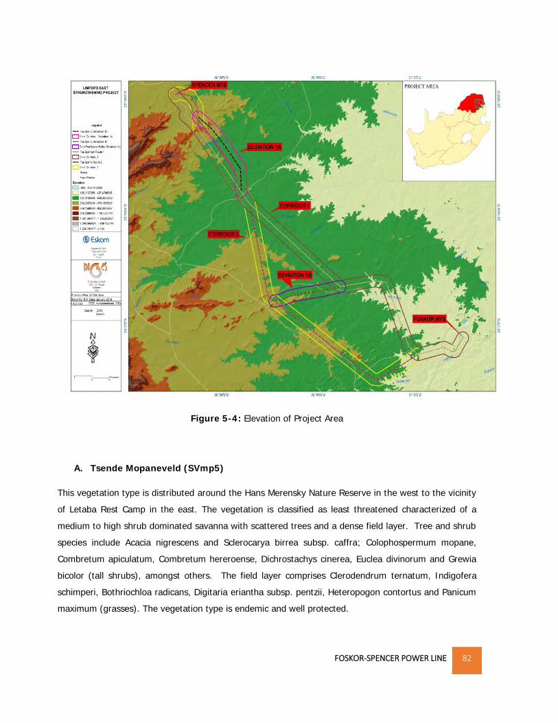
Figure 5-4 overleaf for the elevation of the project area.

5.7 FLORA & FAUNA

5.7.1 FLORA

The threat of an ecosystem status defines the degree to which an ecosystem is still intact or has lost

some of its vital aspects of its structure, function or composition. The proposed power line traverses

across five vegetation types of the savanna type, two of which have been listed as threatened in terms

of the Environmental Management Act (NEM:BA). A detailed Biodiversity Report is attached in

Appendix E-3.

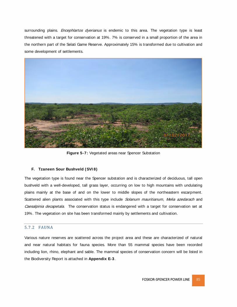
The vegetation within the project area is discussed below. Reference is also made to the Vegetation

Map attached on page 82:

FOSKOR-SPENCER POWER LINE 82

Figure 5-4: Elevation of Project Area

A. Tsende Mopaneveld (SVmp5)

This vegetation type is distributed around the Hans Merensky Nature Reserve in the west to the vicinity

of Letaba Rest Camp in the east. The vegetation is classified as least threatened characterized of a

medium to high shrub dominated savanna with scattered trees and a dense field layer. Tree and shrub

species include Acacia nigrescens and Sclerocarya birrea subsp. caffra; Colophospermum mopane,

Combretum apiculatum, Combretum hereroense, Dichrostachys cinerea, Euclea divinorum and Grewia

bicolor (tall shrubs), amongst others. The field layer comprises Clerodendrum ternatum, Indigofera

schimperi, Bothriochloa radicans, Digitaria eriantha subsp. pentzii, Heteropogon contortus and Panicum

maximum (grasses). The vegetation type is endemic and well protected.

FOSKOR-SPENCER POWER LINE 83

Figure 5-5: Vegetation types within the project area

B. Lowveld Rugged Mopaneveld (SVmp6)

This vegetation type is distributed in the Limpopo and Mpumalanga Provinces. In the project area, it is

distributed around the Foskor substation, parts of Balule Private Nature and Selati Game Reserve. The

vegetation is usually characterized of dense shrubs with occasional trees and a sparse ground layer.

Woody plants can become particularly dense where fire is excluded by very rocky terrain, such as in the

vicinity of the Olifants River. Trees and shrubs found in this vegetation type include: Acacia nigrescens,

Sclerocarya birrea subsp. Caffra, Colophospermum mopane, Combretum apiculatum, Terminalia

prunioides, Acacia exuvialis, A. nilotica and Boscia albitrunca. It is classified as least threatened with a

target conservation status of 19%. 34% is statutorily conserved in the Kruger National Park whilst an

additional 5% conserved in private reserves such as Klaserie, Letaba Ranch and Selati Game Reserve.

Approximately 20% is already transformed mainly by cultivation and some urban and built-up areas.

C. Phalaborwa-Timbavati Mopaneveld (SVmp7)

This vegetation is distributed in Limpopo and Mpumalanga Provinces and occurs south of the Olifants

River between Amalgated Private Nature Reserves and Kruger National Park at an altitude between

FOSKOR-SPENCER POWER LINE 84

300-600m. The vegetation is characterized of open tree savanna on undulating plains with the sandy

uplands dominated by Combretum apiculatum, Terminalia sericea and Colophospermum mopane trees,

with T. sericea. This type is classified as least threatened with a target for conservation set at 19%.

Vegetation type is largely protected in Kruger National Park and the Private Nature Reserves.

Approximately 5% has been transformed, mainly by development of human settlements as well as by

mining. Reference is made to Figure 5-6 below for the vegetation near Selati Game Reserve.

Figure 5-6: Vegetation in some areas near Selati Game Reserve

D. Granite Lowveld (SVI3)

The vegetation type is distributed in Limpopo and Mpumalanga Provinces, Swaziland and marginally

also KwaZulu-Natal. In the project area, it can be found in areas surrounding Murchison and Spencer

Substation. Vegetation is characterized of dense thicket to open savanna with Acacia nigrescens,

Dichrostachys cinerea, Grewia bicolor in the woody layer. The dense herbaceous layer contains the

dominant Digitaria eriantha, Panicum maximum and Aristida congesta. The vegetation type is classified

as vulnerable with a target for conservation set at 19%. 17% is statutorily conserved in the Kruger

National Park. Approximately the same amount conserved in private reserves mainly the Selati,

Klaserie, Timbavati, Mala Mala, Sabi Sand and Manyeleti Reserves. More than 20% is already

transformed, mainly by cultivation and by settlement development.

E. Gravelotte Rocky Bushveld (SVI7)

The vegetation is found in Limpopo Province around the Murchison Range in the Gravelotte area

including surrounding mountains and hills including Ga-Mashishimale. It is characterized of open

deciduous to semideciduous woodland on rocky slopes and inselbergs, contrasting strongly with the

FOSKOR-SPENCER POWER LINE 85

surrounding plains. Encephlartos dyerianus is endemic to this area. The vegetation type is least

threatened with a target for conservation at 19%. 7% is conserved in a small proportion of the area in

the northern part of the Selati Game Reserve. Approximately 15% is transformed due to cultivation and

some development of settlements.

Figure 5-7: Vegetated areas near Spencer Substation

F. Tzaneen Sour Bushveld (SVI8)

The vegetation type is found near the Spencer substation and is characterized of deciduous, tall open

bushveld with a well-developed, tall grass layer, occurring on low to high mountains with undulating

plains mainly at the base of and on the lower to middle slopes of the northeastern escarpment.

Scattered alien plants associated with this type include Solanum mauritianum, Melia azedarach and

Caesalpinia decapetala. The conservation status is endangered with a target for conservation set at

19%. The vegetation on site has been transformed mainly by settlements and cultivation.

5.7.2 FAUNA

Various nature reserves are scattered across the project area and these are characterized of natural

and near natural habitats for fauna species. More than 55 mammal species have been recorded

including lion, rhino, elephant and sable. The mammal species of conservation concern will be listed in

the Biodiversity Report is attached in Appendix E-3.

FOSKOR-SPENCER POWER LINE 86

5.7.3 AVI-FAUNA

The proposed project area is characterised by natural and near natural environment consisting of open

woodland, shrub land and grassland habitat potential for hosting a variety of avi-faunal species. The

presence of rivers, drainage lines and dams also offers habitat for breeding and foraging wetland

associated species. According to Van Rooyen, 2017, SABAP 2 reporting rates for large power line

sensitive Red Data vultures and eagles occurring in the study area are generally high, which is a strong

indicator of a healthy ecosystem, which is certainly the case with the areas utilised for game farming and

eco-toursim. Red Data species that could potentially occur in undisturbed woodland in the study area are

Lanner Falcon, Verreaux's Eagle (around koppies), European Roller, Marabou Stork, Bateleur, Tawny

Eagle, Cape Vulture, Martial Eagle, Lappet-faced Vulture, Southern Ground-Hornbill, Bat Hawk, White-

backed Vulture, Hooded Vulture and White-headed Vulture. The disturbed woodland in the subsistence

farming areas is unlikely to regularly support the same rich complement of raptors, but vultures also forage

in those areas. A detailed Avi-fauna Impact assessment is attached in Appendix E-2.

5.8 CRITICAL BIODIVERSITY AREAS

The current Systematic Biodiversity Plan for the province is the Limpopo Conservation Plan (version 2)

whose purpose is to inform land-use planning and development on a provincial scale and to aid in

natural resource management. One of the outputs is a map of Critical Biodiversity Areas (CBA’s) and

Ecological Support Areas (ESA’s) which are classified into different categories based on biodiversity

characteristics, spatial configuration and requirement for meeting targets for biodiversity pattern and

ecological processes. Table 5-4 describes the different classes and their coverages thereof within the

District Municipality. Figure 5-8 shows the different classes traversed by the proposed corridors:

FOSKOR-SPENCER POWER LINE 87

Table 5-4: CBA Categories

CBA MAP CATEGORY DESCRIPTION % COVERAGE

Protected Areas Declared and formally protected areas under

the Protected Areas Act, such as National Parks,

legally declared Nature Reserves, World

Heritage Sites and Protected Environments

30.8

Critical Biodiversity Area (CBA1) are sites that are required to meet each

ecosystem’s biodiversity targets

18.7

Critical Biodiversity Area (CBA2) The selected sites are the ones that best

achieve targets of the systematic biodiversity

plan though their areas that might achieve

these targets.

13.6

Ecological Support Area (ESA1) Areas that are important for maintaining the

ecological processes on which CBAs depend.

These are largely natural areas.

9.50

Ecological Support Area (ESA2) These areas are no longer intact but potentially

retain significant importance from a process

perspective.

8.40

Other Natural Areas Areas that still contain natural habitat but that

are not required to meet biodiversity targets.

11.9

No Natural Areas These are areas without intact habitat

remaining.

7.3

The table above shows that protected areas and CBA1 areas constitute a larger percentage of the area

in the District Municipality. The Nature Reserves traversed by the power line corridors are classified as

CBA1 areas whilst the areas near the Spencer substation are classified as Other Natural Areas and No

Natural Areas. This is largely due to the human activities such as settlements and subsistence farming.

FOSKOR-SPENCER POWER LINE 88

Figure 5-8: CBA Areas within Project Area

5.8.1 PROTECTED AND NATURE RESERVES

According to the Draft Mopani Bioregional Plan, protected areas including a portion of the Kruger

National Park (KNP) cover 31.7% of Mopani District and private reserves cover an additional 10.2%.

The Associated Private Nature Reserves (APNR) represents the bulk of the Private Nature Reserves

(PNR) that are within the project area. The APNR is comprised of:

a) Timbavati Private Nature Reserve;

b) Umbabat Private Nature Reserve;

c) Klaserie Private Nature Reserve; and

d) Balule Private Nature Reserve

These areas are not formally protected by law but are considered to be conservation areas which also

represent part of the Kruger to Canyons Biosphere Region. The proposed project area traverses across

the Balule Private Nature Reserve and other nature reserves. The table overleaf and the Figure 5-8 lists

and shows the Nature Reserves within and in close proximity to the corridors.

FOSKOR-SPENCER POWER LINE 89

Table 5-5: Protected and Conservation Areas within and near the Project Area

Name Management

Authority

Distance from Corridors

Protected Areas

Kruger National Park SANParks - 7.5km east of corridors

Letaba Ranch Nature Reserve LEDET - 9km north east of Alternative 1;

- 14km north east of Alternative 2.

Hans Merensky Nature Reserve LEDET - 2km north east of Alternative 1;

- 8km north east of Alternative 2.

Conservation Areas

Amalgated Private Nature

Reserves

Private - Corridor will traverse across some

portions of Grietjie.

Selati Game Ranch Private - Corridors will traverse across the

nature reserves.

Solomon Private Nature Reserve Private - Alternative 1 traverses across it;

- 9km North East of Alternative 2

J.S.A. Macdonald Private Nature

Reserve

Private - < 5km from both corridors

Marbadane Nature Reserve Private - 2.8km North East of Alternative 1;

- 23.6km North East of Alternative

2.

Thankerton Private Nature Reserve Private - 10km South West of Alternative 1;

- Alternative 2 crosses the reserve.

Mazunga Private Nature Reserve Private - 15.6km South West of Alternative

1;

- < 2km from Alternative 2.

Andeon Private Nature Reserve Private - 13km South West of Alternative 1;

- < 1km from Alternative 2

Sannie Private Nature Reserve Private -

Volstruis Nature Reserve Private - Alternative 1 traverses across it;

- 10km North East of Alternative 2

Parks Ranches Nature Reserve Private - Alternative 1 crosses at the border

John Roux Nature Reserve Private - 6.5km North East of Alternative 1

Chester Nature Reserve Private - Both corridors traverse across the

reserve.

Ndzalama Private Nature Reserve Private - Alternative 1 traverses across the

reserve;

- <500m North East of reserve.

Vyeboom Private Nature Reserve Private - 4.5km North East of Alternative 1;

- 12km North East of Alternative 2.

Platveld Private Nature Reserve Private - <500m from Alternative 1;

- 14km from Alternative 2.

FOSKOR-SPENCER POWER LINE 90

Figure 5-9: Protected areas and nature reserves within project area

5.9 LAND USE

Land cover data indicates that 86% of the Mopani District is in a natural or near-natural state and this

is largely due to the conservation and protected areas that are within the District Municipality. (Draft

Mopani District Bioregional Plan, 2016) The alternative power line corridors will traverse these areas as

shown in Figure 5-10. The land cover within the protected and conservation area is characterized of

woodland, open bushland, thicket or dense bushland and grassland. Foskor substation and some

sections of the power line corridors traverse across mining areas in Phalaborwa and Gravelotte.

FOSKOR-SPENCER POWER LINE 91

Figure 5-10: Land cover within project area

FOSKOR-SPENCER POWER LINE 92

The following rural settlements are located in areas surrounding Spencer substation:

Ga-Femane;

Gamela;

Ga-Mawa Block 6 and 7;

Ga-Maloko;

Mawa;

Nyakelani;

Ooghoek;

Polaseng;

Senakwe; and

Xihoko.

Subsistence agriculture and grazing also occurs close to these settlements. Commercial agriculture is

also concentrated along the Groot Letaba River.

5.10 ARCHAEOLOGICAL AND PALEONTOLOGICAL ATTRIBUTES

According to the National Heritage Resources Act, 1999 (Act No.2 of 1999) objects that may be

affected include the burial sites, buildings of more than 60 years of age, special geological features

(fossil prints and bushman rock art) and paleontological objects. Clearing the area may result in the

discovery of such objects. Construction of the service access roads, the proposed substation extension

and power lines could potentially impact on heritage sites. A detailed heritage study is attached in

Appendix E-5.

5.11 VISUAL ENVIRONMENT

The visual character of the environments through which the corridor alternatives would pass is quite

varied, characterised by rural settlements, cultivated, mining and conservation areas. Areas close to the

two substations, Foskor and Spencer are characterised of power lines of different voltages. These

power lines traverse the area for distances between 5- 10km. A visual impact report is attached in

Appendix E-8.

5.12 AIR QUALITY

Several activities associated with transmission line construction can cause particulate matter and gases

to enter the atmosphere and degrade air quality. Particulate matter originates from smoke from open

burning of waste vegetation as well as from dust generated by construction activities. Gaseous

FOSKOR-SPENCER POWER LINE 93

hydrocarbons and oxides of sulfur and nitrogen are emitted from vehicle exhaust and open burning.

The impact that these air pollutants have on sensitive persons or crops depends on topographic and

meteorological factors, as well as the amount of each pollutant emitted. The air quality in areas

surrounding Foskor substation is generally poor due to the mining activities undertaken in the area. The

topography of the area also contributes to poor air quality by trapping air pollutants in the atmosphere

under stable atmospheric conditions. The main impacts on air quality result from pollution and dust

emissions from mining, agricultural, domestic and industrial activities.

5.13 SOCIO-ECONOMIC ENVIRONMENT

According to Tony Barbour, 2007, there is a need to understand the social environment and

communities affected by the proposed development in order to ensure that positive benefits associated

with the project are enhanced and the negative impacts are avoided or mitigated. There is therefore a

need to collect baseline data on the current social environment and historical social trends. This section

therefore covers the socio-economic profile of the area at a local and regional level. Desktop review of

the Mopani District Municipality, Greater Letaba, Greater Tzaneen, Ba-Phaloborwa and Maurelng Local

Municipalities Integrated Development Plans and documents pertaining to the project area were

consulted.

5.13.1 POPULATION DEMOGRAPHICS

According to Census 2011, Mopani District’s population accounts for 20.1% of the Province’s population

whilst Greater Tzaneen Local Municipality has the highest population within the district accounting for

35.7%. Table 5-6 show the total land area and population per municipality within the District

Municipality.

Table 5-6: Population and Municipal Land Coverages

Municipalities Population % of District

Population

Land Area % of District Land

Area

Greater Tzaneen 390 095 35.7 3 242.6km2 16.2

*Greater Giyani 244 217 22.4 4 171.6km2 20.8

Greater Letaba 212 701 19.5 1 890.9km2 9.4

Ba-Phalaborwa 150 637 13.8 7 461.6km2 37.3

Maruleng 94 857 8.7 3 244.3km2 16.3

Mopani District 1 092 507 100 20 011 km2 100

Source: Mopani District IDP (2016/17 version 1)

*Local Municipality is not within the project area

FOSKOR-SPENCER POWER LINE 94

Ba-Phalaborwa accounts for 13.8% of the District’s population though it occupies the largest area

within the District. This can be attributed to the nature reserves that are within the Local Municipality

which occupy large tracts of land. Greater Letaba Local Municipality is largely rural accounting for

94.3% respectively per the Local Municipality’s population whilst Ba-Phalaborwa has the highest urban

and farming population accounting for 51% and 12.8% respectively. (Source: Mopani District

Municipality IDP 2016/17 version 1)

The percentage growth of population for Ba-Phalaborwa has increased immensely by 14.9% from 2001

to 2011. This growth is higher than the District Municipality and it can be attributed to the mining and

conservation activities being undertaken in Phalaborwa and Gravelotte. Greater Letaba Local

Municipality population decreased by 3.4% and this can be attributed to out-migration.

5.13.2 GENDER

In almost all local municipalities there are more females than males. This is significant in Greater

Letaba Municipality which is primarily rural in nature. This could be attributed to low levels of education

intensified by the out migration by men seeking jobs elsewhere. Ba-Phalaborwa has comparable

balance in numbers between females and males, however with more males than females work within

the economically active age group.

5.13.3 LANGUAGE

According to Mopani District Municipality 2016/17 IDP, the most dominant languages are Northern

Sotho and Tsonga accounting for 46% and 44% respectively of the total district’s population. Akrikaans

and English account for 2% and 1.3% respectively.

5.13.4 LEVEL OF EDUCATION

Education is very important in one’s life. It creates a range of options which a person can choose from

and it also opens doors to better opportunities and great achievements. The District Municipality has a

low level of education accounting for 40% of the adult population being regarded as functionally

illiterate. Approximately 13,7% have only completed some form of primary education whilst 6.5% has

completed some form of higher education. (Mopani District IDP version 1)

5.13.5 EMPLOYMENT PROFILE

The farming sector is the second largest employer within the District Municipality employing 25.9% of

the District population. In Ba-Phalaborwa, mining is the second largest employer accounting for 19.5%

of the population. 39% of the economically active population in the District are unemployed, 60% of

FOSKOR-SPENCER POWER LINE 95

which are women. The unemployment rate is higher in Greater Tzaneen accounting for 42% of the

district’s unemployed population.

5.13.6 HOUSEHOLDS BY DWELLING TYPE

There are four broad types of settlements within the District Municipality which are distinguished

primarily by the availability of services and the security of tenure. The settlements are described as

follows:

i. Formal Urban Settlements

These have a formal layout, are serviced with a full range of municipal services and the settlement

households can obtain security of tenure. These include areas such as Phalaborwa, Gravelotte,

ii. Tribal Settlements

Large areas of land in the District, mainly Greater Letaba Municipality are owned by the National

Government of South Africa and former Lebowa and Gazankulu Government with tribal and community

authorities as custodians. These traditional authorities play a very important role in terms of their

traditional culture and therefore also have a major influence in the manner in which land is made

available to individuals for settlement, as well as the use for economic purposes.

iii. Rural Settlements

These are settlements that are similar in nature to the tribal settlements regarding the residential

densities and functions, but they are not located on tribal land.

5.13.7 ACCESS TO SERVICES

Access to social and economic services enables people to participate fully in the economy and their

communities. When services such as water, energy and transport are available to people, they can

spend more time doing profitable work, and communication establishes a vital link between people and

the outside world.

Energy

Eskom provides electricity for lighting to most of the communities within the Mopani District

Municipalities. The most frequent use of electricity in Ba-Phalaborwa Local Municipality and Greater

Letaba Local Municipality is lighting accounting for 90.8 % electricity for lighting.

Water

Mopani District Municipality is the Water Service Authority (WSA) and is responsible for bulk water

supply and sanitation facilities within the local municipalities. The municipalities are responsible for

water reticulation in agreement with the district municipality.

FOSKOR-SPENCER POWER LINE 96

Toilet facilities

The towns and their extensions have well developed sanitation systems whilst most rural areas do not

due to their dispersed nature which makes it difficult to provide services. Most dwellings in the rural

areas use pit latrines or have no sanitation facilities at all.

Refuse removal and Waste Disposal

Most of waste management services by municipalities are prioritized in urban areas (townships &

towns) and most of rural communities in the Mopani District Municipality do not have access to waste

removal services by their local municipalities. This results to residents in rural areas dispose waste on

their own, often to illegal dumping occurring. According to Census 2011, Ba-Phalaborwa Municipality

has the highest percentage (48.8%) of refuse removal per week whilst Maruleng Local Municipality only

accounts for 5.9% of refuse removal per week.

There are only two local Municipalities, Greater Tzaneen and Maruleng with legal landfill sites whilst

Greater Letaba transports its waste to Greater Tzaneen.

5.13.8 ECONOMIC ACTIVITY

The mining sector is the largest contributor of the Mopani District Municipality’s Gross Domestic Product

(GDP) constituting 30% whilst agriculture is the most important sector in Greater Tzaneen, Greater

Letaba and Maruleng Local Municipalities. Mining is concentrated in Ba-Phalaborwa Local Municipality

where it contributes approximately 80% of the Local Municipality’s GDP and employs more than 2 000

people and an additional 450 contractors. The major mining activities in the region are concentrated in

Phalaborwa in the Phalaborwa Mineral complex which has been declared a Spatial Development

Initiative (SDI). The objectives of the SDI is to exploit the unutilized and underutilized potentials of the

area by combining private and public sector resources in a sustainable manner. Other significant

mineral zones in the region are the Murchison Greenstone Belt (Gravellotte towards Leewkop in the

Kruger National Park [KNP]), Giyani Greenbelt-from KNP in the south Western direction to the town of

Giyani, and Rooiwater Complex Northern flank of Murchison.

Agriculture is predominant in Tzaneen, Maruleng and Letaba where ZZ2 dominates the industry in

terms of output and the major focus is on sub-tropical fruit. These two industries focus is to produce

for exportation. According to Mopani District Municipality’s IDP, Greater Letaba currently makes the

least contribution to the District’s GDP.

FOSKOR-SPENCER POWER LINE 97

5.13.9 TOURISM

Tourism is deemed to be an engine that drives growth and development in areas and is often seen as a

mechanism for local communities to capitalize on assets such as the natural environment and cultural

heritage. In Mopani District Municipality, it also plays an important role. The indigenous forests,

biospheres, nature reserves, wetlands, endangered species as well as Kruger National Park offer

several opportunities for tourism. These include opportunities for eco-tourism, as well as tourism

associated with the variety of historical and cultural interests found within the district. Mopani District is

also considered the home of the big five due to abundance of such animals in Kruger National Park and

surrounding private game farms and nature reserves. The numerous nature reserves within the district

include: Selati Game reserve, Chester Reserve, Ndzalama Wildlife Reserve, Klaserie, Thorny Bush and

Timbavati, Westfalia Estates, Merensky Reserve, Letaba Ranch, Geothermal springs in Hans merensky

Nature Reserve and Soutini Baleni, Manotsa and Madrid and Shiluvane. Tourism related activities

offered in these areas include: hiking, white water rafting, abseiling, hot air ballooning, rock climbing

and bird watching. A Tourism Impact Assessment will be carried out during the EIA and the report

detailing the impacts of constructing the power line in the area will be attached to the Environmental

Impact Report.

Airports

There are several landing strips within the area which play a significant role in increasing tourist traffic

and establishing the area as a gateway to the Kruger National Park and the surrounding areas. There

are two airports within the 3000m corridor located on Archie 156KT and Lillie 148KT with the landing

strip having a length of 1.1km. These airports cater for visitors to the Boulders Game Ranch. Two other

airports are also near the corridors, namely Hendrick Van Eick Airport and Gravelotte Airports which are

approximately 9km and 4km south west of the corridors.

FOSKOR-SPENCER POWER LINE 98

6. OVERVIEW OF SPECIALISTS SURVEY

The first site inspection undertaken by both Consultants and applicant was sort of reconnaissance field

survey where different components of the environment that are likely to be affected by the proposed

development were briefly assessed. Based on the environment observed and the nature of the

development, there was a need to have an in depth understanding of the status quo of various aspects

of the environment and how the development will have an impact on these environmental aspects.

Specialists’ studies were therefore required to inform the Environmental Impact Assessment Process by

considering the specific nature of the environment within which the development is to be undertaken.

The results of these studies will serve as a basis to identify the potential impacts expected should the

development be undertaken. Noise and air quality impacts while important are likely to be less

significant hence they will not require a specialist assessment. This report includes the specialist impact

assessment reports commissioned as part of the environmental process and a summary of the Avi-

faunal, Bodiversity, Heritage, Palaeontology, Social, Soil and Land Capability, Tourism, Visual and

Wetland Assessment is given in the sections below. The detailed reports are attached in Appendix E-2

to E-9 respectively.

6.1 AVI-FAUNA IMPACT ASSESSMENT

The Avi-fauna Impact study was carried out by Chris Van Rooyen Consulting and the full report is

attached in APPENDIX E-2.

The Terms of Reference were as follows:

Describe the affected environment;

Indicate how birdlife will be affected;

Discuss gaps in baseline data;

Describe and assess the expected impacts;

Indicate sensitive and possible no-go areas; and

Provide recommendations for mitigating measures.

6.1.1 ASSUMPTIONS AND LIMITATIONS

The following assumptions and limitations were made:

FOSKOR-SPENCER POWER LINE 99

SABAP2 is regarded as fairly comprehensive as there have been significant studies undertaken;

and

Though conclusions are based on experience and similar species in different parts of South

Africa, power line impacts were predicted with a fair amount of certainty due to the published

research carried out over a long period of time.

6.1.2 METHODOLOGY

The following sources were consulted:

i. South African Bird Atlas 2 (SABAP2) for the bird distribution data;

ii. Important Bird Areas (IBA) for an overview of the important bird areas and species diversity

within and surrounding the project area;

iii. Endangered wildlife Trust for the species that may be impacted upon by the power line;

iv. Vegetation Map of South Africa for the vegetation types within the project area;

v. South African Red Data for birds and the latest IUCN Red list for the conservation status of all

species likely to occur in the area;

vi. Kerri Wolter at Vulpro and Selati Game Reserve for the location of Cape Vulture colonies and

restaurants; and

vii. South Africa Protected and Conservation Areas data from DEA for protected areas within and

around the project area.

In addition, a field visit was undertaken by the specialist on the 1st- 2nd of February 2017. Personal

observations based on previous studies/assessments undertaken was used to supplement the data

from the field surveys and desk top study.

6.1.3 IMPACT ASSESSMENT

‘Excerpt from the Avi-fauna Report’

The habitat through which the proposed Foskor – Spencer 400kV corridors run is low to moderately

sensitive from a potential bird powerline impact perspective, with a few areas of high sensitivity,

namely rivers, dams and a vulture restaurant. The natural woodland habitat in the game farming and

eco-tourism areas between Foskor substation and the R529 is likely to attract a number of Red Data

power line sensitive species, mostly eagles and vultures, while the rivers are attractive to several Red

Data powerline sensitive stork species, as well as vultures and eagles. Between the R529 and the

Spencer substation the main economic activity is subsistence farming, with evidence of anthropogenic

impacts, which is visible in the disturbed state of the majority of the woodland. This has had a negative

FOSKOR-SPENCER POWER LINE 100

impact on avifaunal diversity and abundance, with fewer Red Data species expected to be attracted to

this section of the study area.

The construction of the proposed power line will result in various potential impacts on the birds

occurring in the vicinity of the new infrastructure, with impacts ranging from low to moderate. The

proposed power line poses a moderate collision risk which can be reduced to low through the

application of mitigation measures. The habitat transformation and disturbance associated with the

construction and decommissioning of the power line should have a moderate displacement impact,

which could be reduced to low with appropriate mitigation. No electrocution risk is foreseen.

6.1.4 CONCLUSIONS AND RECOMMENDATIONS

Based on the potential negative impacts expected on Red Data species, the study area was delineated

into high, medium and low sensitivity and the total surface area per each category was calculated for

each proposed corridor with the least amount of highly sensitive habitat was selected as the preferred

corridor (Reference is made to Appendix 6-1 for the sensitivity map).

Based on the methodology used in terms of sensitivity, Corridor 2 and Deviation 1a is the

preferred route. However, the other corridor options are viable provided that the proposed

mitigation measures are implemented. Reference is made to the map overleaf:

Mitigation for displacement:

The primary means of mitigating this impact is through the selection of the optimal

route for the line. This will ensure that high sensitivity habitats (e.g. rivers, dams and

vulture restaurants) are avoided as far as possible;

Construction activity should be restricted to the immediate footprint of the

infrastructure;

Access to the remainder of the site should be strictly controlled to prevent unnecessary

disturbance of Red Data species;

Measures to control noise should be applied according to current best practice in the

industry;

Maximum use should be made of existing access roads and the construction of new

roads should be kept to a minimum.

The recommendations of the ecological and botanical specialist studies must be strictly

implemented, especially as far as limitation of the construction footprint and

rehabilitation of disturbed areas is concerned.

FOSKOR-SPENCER POWER LINE 101

Figure 6-1: Avi-fauna Sensitivity Map

The final powerline alignment must be inspected on foot by the avifaunal specialist

prior to construction to ascertain if any Red Data species nests are present. All relevant

detail must be recorded i.e. species, coordinates and nest status. Should any nests be

recorded, it would require management of the potential impacts on the breeding birds

once construction commences, which would necessitate the involvement of the

avifaunal specialist and the Environmental Control Officer.

An effective communication strategy should be implemented whereby the avifaunal

specialist is provided with a construction schedule which will enable him/her to

ascertain when and where such breeding Red Data species could be impacted by the

construction activities. This could then be addressed through the timing of construction

activities during critical periods of the breeding cycle, once it has been established that

a particular nest is active.

Mitigation for collisions:

High risk sections of power line must be identified by a qualified avifaunal specialist

during the walk-through phase of the project, once the alignment has been finalized.

Where power line marking is required (i.e. in areas that contain rivers, dams or is

situated near a vulture restaurant) bird flight diverters must be installed on the full

FOSKOR-SPENCER POWER LINE 102

span length on each earthwire (according to Eskom guidelines - five metres apart).

Light and dark colour devices must be alternated so as to provide contrast against both

dark and light backgrounds respectively. These devices must be installed as soon as

the conductors are strung.

6.2 BIODIVERSITY IMPACT ASSESSMENT

The Biodiversity Impact Study was carried out by BioAssets (Dr. Wyland Vlok) and the full report is

attached in Appendix E-3.

The Terms of Reference were:

Undertake baseline survey and describe affected environment within the project footprint;

Take into consideration the Limpopo Conservation Plan;

Assess the current ecological status and the conservation priority within the project footprint;

Undertake sensitivity study to identify protected species, Red Data species, alien species and

fauna within the servitude;

Compile a plant rescue and protection plan which allows for the maximum transplant of

conservation of important species from areas to be transformed;

Prepare maps that indicate critical biodiversity areas and ecological support areas; critical and

endangered vegetation areas; and

Recommend the preferred alternative and mitigation measures.

6.2.1 ASSUMPTIONS AND LIMITATIONS

Prevailing weather conditions: during the survey it was hot with light wind blowing and the

region had received rainfall prior to the site visit and there was standing water present. These

conditions will have implications on biodiversity likely to occur in the area. However, the

weather conditions during the survey were ideal;

Due to time constraint, a full survey of plants was not undertaken; and

The study area is large and access to all areas was not always feasible.

6.2.2 METHODOLOGY

A desktop study was undertaken to determine the possible impacts and concerns associated with the

study area in relation to the biodiversity and protected fauna and flora. Field surveys were conducted

FOSKOR-SPENCER POWER LINE 103

and were targeted to identify the different habitat types, threatened species, animal activity and the

potential impacts that the proposed development will have on biodiversity.

6.2.3 SUMMARY OF ASSESSMENT

‘Excerpt from the Biodiversity Report’

The findings from this report can be summarised as:

Substation

It must be noted that more than 1 hectare of indigenous vegetation will be cleared at the Spencer

Substation (9ha is required).

General vegetation clearing for the project – in addition, it must be noted that more than 300m2 of

indigenous vegetation will be removed in the CBA areas.

Alternative 1

The natural vegetation, north of Groot Letaba River is modified and many activities have had a negative

impact on the habitat namely subsistence agriculture, urbanization and overgrazing. The area on the

banks of the river is associated with the narrow band of intensive agricultural activities which are

mostly orchards but it is possible to get a clear corridor of the power line. The riparian vegetation along

the Groot Letaba River is modified and it is possible to get a corridor to cross the river without needing

to remove large riparian trees.

South of Groot Letaba River, the vegetation is modified but still in a fair to good condition due to

previous land-uses such as overgrazing which has led to the encroachment of the shrub and small tree

layer. This has resulted in a modified ecological integrity which is lower than what would be expected in

the well managed area. According to Limpopo Conservation Plan version 2, the area to the south of

Groot Letaba River is characterized of CBA1 and CBA2 zones with associated supported zones. In these

areas, only the corridor for the new power line should be cleared and the grass and small shrub layer

must not be cleared (minimum 300mm) as this will lower the risk of erosion and the establishment of

alien invasive species in the corridor. Though, protected plant species such as Sclerocarya birrea and

Combretum Imberbe were observed, no red data species were found. This should be confirmed prior to

construction. In addition, various exotics were also present within the corridor namely include

Jacaranda mimosifolia, Melia azedarach and Psidium guajava.

Alternative 2

FOSKOR-SPENCER POWER LINE 104

The first section of Alternative 2 differs from Alternative 1 but the main section is the same to the

crossing of Groot Letaba River. The small deviation from Spencer Substation to the east of Alternative 1

crosses similar terrain and vegetation and therefore the impacts and low ecological value is similar to

Alternative 1. According to Limpopo Conservation Plan version 2, the area affected in the north of Groot

Letaba River is classified as CBA2 and ESA2. In these areas the proposed corridor for the power line

must be only cleared from larger vegetation that will impact directly on conductors. The ecological

importance is low. The construction of the power line in this section will therefore have a low impact on

the ecosystem.

South of Groot Letaba River, the vegetation is modified but still in a fair to good condition due to

previous land-uses such as overgrazing which has led to the encroachment of the shrub and small tree

layer. This impact on the basal layer has resulted in poorer grass cover than would be in pristine areas

which has lowered the ecological integrity of the area. In this section of the corridor, there is a small

section of the corridor traversing across CBA1, CBA2 and associated support areas. In these areas, total

clearing of basal layer is prohibited which will ensure that the grass and small shrub layer will lower the

risk of erosion and the establishment of alien invasive plants in the corridor.

From an ecological perspective, this route is also viable. It is noted that historic land use practices have

resulted in modifications to the landscape and associated floral composition. A combination of the

routes will lower the impact on the existing natural vegetation, private reserves and military training

areas.

Deviation 1a and Deviation 1b

Deviation 1a is viable and the area is similar to the route for Alternative 1 whilst Deviation 1b is a better

option as it follows R71 road, open corridors next to fences and the corridor for the existing power and

telephone lines. The ease of access and the use of existing roads will lower the impact on natural

vegetation.

Fauna

The faunal component along the full corridors of the power line vary considerably. In the northern

section (north of the Groot Letaba River) game was not observed and very little evidence of activity

was noted. Some spoor and droppings of Sylvicapra grimmia, Aepyceros melampus, Tragelaphus

strepsiceros, Hystrix africaeaustralis and some smaller rodents were seen. The power line will have very

limited impact on these with some possible disturbance of the rodents if burrows are impacted during

construction.

FOSKOR-SPENCER POWER LINE 105

To the south, the diversity of the animals increased mostly were the game farms are present. In the

cattle areas more Sylvicapra grimmia, Aepyceros melampus, Tragelaphus strepsiceros and Raphicerus

campestris activity were noted due to higher protection and better habitat. Larger species and rare

game are present and include Loxodonta Africana, Syncerus caffer, Panthera pardus, Pantherus leo,

Crocuta crocuta, Equus quagga, Connochaetes taurinus, Giraffa camelopardalis, Hippotragus niger,

Hippotragus equinus and Damaliscus lunatus.

6.2.4 CONCLUSIONS AND RECOMMENDATION

During construction it will be important to liaise with the landowners with regards to the game

present on the different farms (once the final route is selected). Where dangerous animals are

present, it will be important to ensure that game is moved to other camps where possible. A

ranger from the farm must be present during construction to ensure the safety of man and

animals. A concern will be the areas where Loxodonta africana and Giraffa camelopardalis are

present as the former can damage pylons and get electrocuted if conductors are to low and the

latter is exposed to electrocution as well;

With regards to the visual impacts, it is obvious that some structures will be seen from roads

and other infrastructure (houses and camps). The best solution is to follow existing fences and

roads where power lines and telephone lines are present. This will ensure that the power line is

on the boundary of the property and that a minimal visual impact can be achieved.

The corridor for the new proposed power line must be only cleared from larger vegetation that

will impact directly to the conductors. This entail that trimming of larger trees must be done and

it is important that “no total clearing of the basal layer” must be allowed. This will ensure that

the grass and small shrub layer will lower the risk of erosion and the establishment of alien

invasive plants in the corridor. No buffer around the corridor is needed, as only the narrow strip

must be cleared for the proposed power line. The corridor will further act as the access route

during construction. In addition, limited traffic must be allowed in the area and smaller

construction vehicles must be used to transport the materials;

A walk down survey consisting of the surveyor, the engineer and botanist must then be

undertaken to see if it will be necessary to move pylons to lower the need of trimming or

cutting of protected trees. This information is needed for the permit applications to DAFF. No

clearing of the corridor can commence before the permits are issued;

The route must follow existing roads, fences or servitudes, as this will lower the need of cutting

and trimming of trees; and

FOSKOR-SPENCER POWER LINE 106

A formal induction and monitoring of clearing must be done by the botanist to ensure that the

permit regulations are carried out.

6.3 ECO-TOURISM IMPACT ASSESSMENT

The Eco-Tourism Impact Assessment for the project area was carried out by Engwe Scoping Consulting

and the full report is attached in APPENDIX E-4.

The Terms of Reference were as follows:

Provide status of tourism within and in close proximity to the study area;

Identify conservation/protected areas in conjunction with tourism worthy areas;

Identify provincial, regional and local tourism trends;

Identify existing tourism products in surrounding region;

Undertake an impact assessment of the proposed development on existing tourism industry;

and

Identify mitigation measures of the proposed infrastructure on the ecotourism industry.

6.3.1 ASSUMPTIONS AND LIMITATIONS

The following assumptions and limitations were made and encountered:

The length and width of the alignment, as well as the time frames made it almost impossible to

identify and visit every facility along the respective corridors and in the surrounding areas. As

such, the area was researched in a more broad approach with the main focus on desktop

studies;

Tourism is very diverse, as a result, certain aspects of ecotourism experience, specifically

“sense of place” is subjective by nature and could be viewed in a very different light by

different stakeholders;

Given the precinct of some of the area, it is possible that some of the area could have been

used for/ and or earmarked for tourism activities such as mountain biking, hiking and fishing;

Of note is that ecological assessment would take into consideration the impacts on sensitive

habitats/ ecological features which may attract visitors; and

This study was largely desktop, and the actual tourism trends of the area are difficult to

estimate since they are not readily available, and will require in-depth interviews with product

owners.

FOSKOR-SPENCER POWER LINE 107

6.3.2 METHODOLOGY

Firstly, a desktop study was undertaken, this was followed by a field survey and then analysis of

findings. Below is the detailed explanation of activities conducted:

A desktop study entailing observing the South African tourism industry from both a Provincial

and National perspective, taking into consideration trends and potentials, as well as evaluation

of tourists’ destinations found in the area such as nature reserves, private game reserves,

private game farms and lodges, as well as eco-tourism attractions;

A site inspection of the area was undertaken with an aim of verifying tourist’s destinations

and locating any new ones which could have been missed during desktop study. In addition,

the desktop visual impact assessments were undertaken using Google Earth View-shed tools.

6.3.3 ASSESSMENT

‘Excerpt from the Eco-Tourism Report’

Below are some of the major tourists’ destination known to exist in the area proposed for development:

i. Hans Merensky Nature Game Reserve: is a protected area which was proclaimed a nature

reserve in 1953. This approximately 5200 hectares and lies approximately 70km northeast of

Tzaneen toward the Kruger National Park. The terrain also provides an ideal habitat for

hundreds of interesting bird species, including the White-breasted Cuckoo shrike, Brown-

headed Parrot, Raptors and Wood Sandpipers;

ii. Selati Game Reserve: the game reserve has 30500 hectares of privately owned Lowveld

Bushveld situated north of the Olifants River between Mica, Gravelotte and Phalaborwa;

iii. Ndzalama Wildlife Reserve: with animals including four of the Big Five and klipspringer

antelopes roaming its 80-plus km2;

iv. Lekkersmaak Game Reserve: conserves different kinds of wildlife and is privately owned;

v. Leopard rock Cap: is in close proximity to the Kruger National Park with towering boulders

and lush vegetation. Wildlife such as Saddledback Impala, Sable Antelope, Black Impala, Cape

Buffalo, Nyala, Kudu Golden Wildebeest, and Livingstone Eland can be found there.

vi. Jeune Elephant: It offers unique intimate hands-on educational elephant interactions,

elephant-back safaris, swims on elephants as well as tailor-made events such as weddings.

vii. Grietjie Private Nature Reserve: is 30km south of Phalaborwa, and encompasses

approximately 2 800ha including 6km of impressive river frontage on the perennial Olifants

River; and

viii. Inyanga Safari Lodge: a small Bush Lodge, located in the Greater Kruger Park, It is only 20

minutes’ drive from Phalaborwa.

FOSKOR-SPENCER POWER LINE 108

Anticipated eco-tourism impacts include:

The four major impacts likely to result from the transmission line include the following:

A. Visual and Cultural Impacts of the project on Tourism: The first section of the project

area from Foskor substation is largely natural. Leisure tourism is practiced in these areas and

these areas are more likely to be visually affected by power lines and this could affect

negatively on tourism as some tourists visit these areas just to enjoy the beautiful views.

B. Change in land-use: Introducing power lines would be viewed as a change in land use or a

change in natural character. This would therefore spoil the scenic value of these areas and

potentially affect tourism activities. Conversely the proposed power lines are not perceived as a

change in land use in already visually degraded areas such as Phalaborwa and other parts of

Mohlabaneng due to the presence of other linear structures such as roads, other power lines

and buildings.

C. Corporate demand: In general, the impact of the proposed transmission lines on corporate

demand for tourism facilities is anticipated to be huge as the power lines will ensure many

other development projects in future that will increase the need for tourism. It is however very

debatable whether this positive impact on tourism demand in the area would offset possible

losses to the existing eco-tourism or possible development opportunities in this regard.

D. Change or alteration of hunting calendars: During the Public participation meetings held,

some villagers from the Mashishimale CPA raised concerns about the disruption of the hunting

seasons due to the fact that seasonal professional hunters will not be able to hunt during the

construction phase. They raised concern over the issues of poaching and also the safety of the

developers against dangerous wild animals during the construction phase. This would mean

that their usual hunting calendar of May to September will have to be altered in the event that

construction is in their territory during this period. However, expectations of economic benefits

from tourism may be positively impacted with the coming of a better and improved electricity

supply after the construction phase. The construction phase of the project may also disturb

wildlife by altering their eating habits and feeding patterns. Feeding patterns are altered

directly by the construction of utility towers on graving/feeding lands, and indirectly by littering

caused by construction workers on site, which encourages wildlife to scrounge for food.

6.3.4 CONCLUSIONS AND RECOMMENDATIONS

Most impacts associated with transmission lines on the eco-tourism products relate to visual impacts

hence the eco-tourism study takes into account the impacts and mitigation measures detailed in the

FOSKOR-SPENCER POWER LINE 109

Visual Impact Assessment Report. The following mitigation measures for the anticipated impacts are

detailed in Section 8 of this report and the attached EMPr in Appendix G.

Eskom should try and avoid placing towers on areas of scenic natural beauty;

The flood-line needs to be determined, and structures should be avoided below the 1:50 years

flood line;

Eskom should ensure that their construction should not contradict with the hunting season;

Placing the towers on the backdrop of the reserve, such should be discussed with the

landowners.

Eskom must screen construction activity to reduce the impact on tourism, and utilise existing

screening features such as dense vegetation stands or topographical features;;

Construction sites must be kept tidy and litter free to reduce the potential visual impact.

Where new access roads are required, disturbance should be minimized by keeping roads

narrow and using two-track dirt roads wherever possible;

It must also be noted that, smaller towers or those with a more compact design (e.g. cross-

rope suspension towers) should be used.

By keeping the proposed lines as straight as possible, fewer strain towers will be required. This

is preferable as strain towers are visually obtrusive compared to the suspension towers used

when alignments are straight. Should it be necessary to paint, it is recommended that a neutral

matt finish be used.

From a tourism point of view, the proposed construction of a 400kV transmission power line from

Foskor Substation (Phalaborwa) to Spencer Substation (near Giyani) and Spencer MTS Upgrading,

Limpopo Province is expected to a medium risk on tourism in between Mohlabaneng (Spenser) and

Phalaborwa (Foskor) after the implementation of the recommended mitigation measures.

6.4 HERITAGE

The Heritage Impact study was carried out by Vhubvo Archaeo-Heritage Consultants and the full report

is attached as APPENDIX E-5.

The Terms of Reference were as follows:

Undertake a Phase 1 Heritage and Paleontology Impact Assessment in accordance with the

South African Heritage Resources Act (Act No. 25 of 1999);

Undertake baseline study indicating the location of heritage and paleontology resources, the

nature and degree of significance and the present physical condition;

FOSKOR-SPENCER POWER LINE 110

Prepare a heritage and paleontology sensitivity map, based on the findings of the study;

Identify the resources to be monitored; and

Recommend the preferred corridor with mitigations measures to be implemented.

6.4.1 ASSUMPTIONS AND LIMITATIONS

Most of the area proposed for development is encroached by bush which make it almost

impossible to access. It is thus possible that some materials could have been overlooked due to

that the area was investigated only in a broad, overview approach as access to the different

properties was not possible;

Several houses located on the proposed area (s) were noted, and will have to be relocated.

Most of the people in the area proposed for development bury their loved ones at home. The

relocation of people will have a negative effect on grave sites;

It is assumed that the Social Impact Assessment and Public Participation Process might also

result in the identification of sites, features and objects, including sites of intangible heritage

potential in the corridors and that these will also have to be considered in the selection of the

preferred corridor; and

It is also assumed that a Visual Impact Assessment will be done to determine the impact of

development on any identified heritage sites.

6.4.2 METHODOLOGY

The Heritage Impact was conducted by the means of the following:

i. Literature Review: To understand the background archaeology of the area, a background

study was undertaken and relevant institutions were consulted. These studies entailed review

of archaeological and heritage impact assessment studies that have been conducted around

the proposed area thorough SAHRIS. In addition, E-journal platforms such as J-stor, Google

scholars and History Resource Centre were searched. The University of Pretoria’s Library

collection was also consulted;

ii. The field survey was conducted from the 1st to the 9th of February 2017, this also included

public consultations and oral interviews;

iii. The final step involved the recording and documentation of relevant archaeological resources,

as well as the assessment of resources in terms of the heritage impact assessment criteria and

report writing, as well as mapping and constructive recommendations.

FOSKOR-SPENCER POWER LINE 111

The applicable maps, tables and figures, are included as stipulated in the NHRA (no 25 of 1999), the

National Environmental Management Act (NEMA) (no 107 of 1998) and the Minerals and Petroleum

Resources Development Act (MPRDA) (28 of 2002).

6.4.3 IMPACT ASSESSMENT

‘Excerpt from the Heritage Impact Assessment’

Corridor 1

The first corridor stretches on an unused land and sections of nature reserves, these areas are ideal for

isolated archaeological materials, or historic settlement such as stone walling which are known to

spread across the area. This corridor also transverse over active farmlands and villages, especially

towards Spencer Substation. Farmers and villagers in these areas are known to bury their loved ones in

their place of dwelling. Making this an ideal place for finding either known or unknown burial.

Corridor 2

This corridor is located on a similar landscape to that of Corridor 1. However, this one also transverses

over airports and several main roads as well as perennial streams and watercourse, of significance is

that this corridor transverses across sections of Olifants North Game Reserve which is one of the

reserve which is still intact. Archaeologically, Nature Reserves are considered sensitive since they have

not had many disturbances due to that they are a protected landscape. This area thus remains

sensitive form an archaeological point of view.

Deviation (s)

Furthermore, to these two corridors, two deviations are proposed and are referred to as 1a and 1b.

Deviation 1a is on an area which is under extreme residential sites. There is no large-scale farming

activities on this area and family graves are expected in this area due to its high residential setting. The

second deviation referred to as 1b is at the boundary of Selati Game Reserve, running parallel an

existing 132kV power line and traverses undulating environment, this area is also characterised by

isolated farmsteads.

The significance of the loss of archaeological and grave sites for all alternative corridor is low whilst

the magnitude is classified as medium. The graves observed within the corridors are given in the Table

6-1 and Map 6-2:

Table 6-1: Information of some of the archaeological/ heritage sites noted in the proposed area

FOSKOR-SPENCER POWER LINE 112

Site Coordinates Description Significance

Spe001 23.48158°S

30.42467°E

Informal grave site (s) with marked and

unmarked graves was noted on the area

proposed for Corridor 2.

High if a

grave site

Spe002 23.49391°S

30.41997°E

An abandoned settlement was noted on the area

proposed Corridor 2.

High

Spe003 23.60836°S

30.49391°E

Grave site was noted in Ga-Mawa which consists

of marked and unmarked graves.These graves

are located within the project servitude on the

area of deviation route 1a.

High

Spe004 23.65713°S

30.67114°E

Muti wa Vatsonga Open Museum approximately

10.9km and 13km east of Deviation 1a and

Corridors 1 and 2 respectively.

Medium

The only sign of sites of heritage potential were mostly graves (Especially on Corridor 2), and this can

be avoided. Nonetheless, there is also a high chance of finding archaeological sites and this will be

difficult to avoid since most of these are trifling and often hidden underground, only exposed once

construction begins.

6.4.4 CONCLUSION AND RECOMMENDATIONS

Although no remains of Stone/ Iron Age sites were noted during site visit, the area could still

contain camps and some areas with suitable substrates that could have been used as quarries

for material to produce tools, particularly within Nature Reserves.

Taking all the above information into account, it can be recommended that Corridor One (1)

is the preferred alternative from a heritage impact perspective. Noteworthy that all grave sites

should be avoided in the best way possible.

Two alternatives were investigated for the deviations. Option (s) 1a and 1b. The first option, 1a has the

high level of heritage sensitivity. However, Option 1b showed minimal signs of heritage sites. It is

therefore recommended that Option 1b can be used as a deviation from Corridor 1 to Corridor

2. It should still be noted that no site (s) can be found within 1a can be of such high significance such

that construction may not be possible. As the exact coordinates for the power line and the individual

tower structures are not yet available, it is difficult to determine what the final impact of the proposed

development would be like.

FOSKOR-SPENCER POWER LINE 113

Figure 6-2: Location of Archaeological and grave sites

Henceforth, for the project to continue the archaeologist recommended the following:

i. A heritage practitioner should complete a “walk down” of the final selected power line

servitudes, the chosen deviation location and all other activity areas (access roads,

construction camps, etc.) prior to the start of any construction activities. This walk down

will document all sites, features and objects, in order to propose adjustments to the routes

and thereby to avoid as many impacts to heritage as possible.

6.5 PALEONTOLOGY

The Paleontology Study was carried out by Dr J.F. Durand and the full report is attached as

APPENDIX E-5.

The Terms of Reference were as follows:

To detail the probability of finding fossils in the study area which may be impacted by the

proposed development.

FOSKOR-SPENCER POWER LINE 114

6.5.1 METHODOLOGY

Relevant literature and geological maps were studied.

6.5.2 DESKTOP STUDY

Several mines occur in this mineral-rich region the largest of which is in Phalaborwa. The study area

varies from No to Low Paleontological Sensitivity according to SAHRA. The relevant literature and

geological maps have been studied for a Desk Top Study. The rocks of the study consist of igneous and

metamorphic rocks of between 3333 and 2060 Ma. These rocks are of no palaeontological concern.

The fossil record of the overlying Quaternary-aged sands is sparse, occurs sporadically and is low in

diversity. Although no fossils have been reported for the study area, fossils such as root casts, burrows,

termitaria, ostrich egg shells, mollusc shells and isolated bones have been discovered in the Quaternary

sands elsewhere (Almond & Pether 2008).

6.5.3 RECOMMENDATIONS

The area is underlain by igneous and metamorphic rocks of Swazian to Vaalian aged igneous rocks

(3.33 – 2.05 Ga). Due to the very low probability of fossils occurring in the study area it is

recommended that the project should be exempted from further palaeontological studies.

6.6 SOCIAL IMPACT ASSESSMENT

The Social Impact Assessment for the project area was carried out by Afro Conserva Intergration and

the full report is attached in APPENDIX E-7.

The Terms of Reference were as follows:

i. To describe the social characteristics of the affected population as well as the cultural and

socio-political dynamics in the broader project area;

ii. To identify relevant social aspects and the anticipated impacts associated with the proposed

project; and

iii. To identify viable mitigation measures and project related benefits.

6.6.1 ASSUMPTIONS AND LIMITATIONS

The following assumptions and limitations were made and encountered:

This study was carried out with the information available to the specialist at the time of

executing the study, within the available timeframe and budget. The sources consulted are not

FOSKOR-SPENCER POWER LINE 115

exhaustive and additional information, which might strengthen arguments or contradict

information in this report might exist;

The specialists did endeavour to take an evidence-based approach in the compilation of this

report and did not intentionally exclude scientific information relevant to the assessment;

It was assumed that the motivation for, and the ensuing planning and feasibility studies of the

project were done with integrity, and that the information provided to date by the project

proponent, the independent environmental assessment practitioner and the public participation

consultant was accurate;

The information contained in this report has been compiled with the utmost care and accuracy

within the parameters specified in this document. Any decision based on the contents of this

report is, however, the sole responsibility of the decision maker.

6.6.2 METHODOLOGY

A social baseline study was undertaken and it made use of the following information:

existing data;

comments received during the public participation process;

Published reports including the Integrated Development Plans; and

Statistical data obtained from Statistics South Africa; and

Social Impact Assessment literature.

6.6.3 ASSESSMENT

In order to assess the potential impact of the proposed project, it was important to consider Limpopo

Province, District Municipalities and Local Municipalities as well as nearby towns in a holistic way. The

baseline study therefore included a brief over-view of the socio-economic factors in these areas with a

thorough investigation into the affected 4 Local Municipalities, Ba-Phalaborwa, Greater Letaba, Greater

Tzaneen and Maruleng. The following detailed information is documented in the Social Impact

Assessment attached in Appendix E-7:

Demographic Profile which includes population and household, population group, age and

education profile; and

Economic Profile which includes employment and labor, services and infrastructure, housing,

energy use, water, roads and transport.

The anticipated socio-economic impacts expected include the following:

i. Waged labour;

FOSKOR-SPENCER POWER LINE 116

ii. Capacity Building and Skills Development;

iii. Influx of construction workers;

iv. Inflow of workers;

v. Gendered division of labor;

vi. Accommodation of workers;

vii. Local economic contribution;

viii. Socio-economic Processes;

ix. Conversion: Geographic;

x. Increase in demands for service

xi. Property value;

xii. Displacement and Relocation of households;

xiii. Property Value;

xiv. Displacement and Relocation;

xv. Existing Residential;

xvi. Game farms and nature reserves; and

xvii. Tourism and visual.

6.6.4 CONCLUSION AND RECOMMENDATIONS

‘Excerpt from the Social Impact Assessment Report’

From a social perspective based on the initial assessment of the receiving environment, there will be no

fatal flaws associated with the proposed development that can have grave social consequences. The

proposed development will have varying negative/ positive impacts ranging from high to low in the

area proposed for development. It is apparent that there is little differentiation between the proposed

alternatives assessed, either-way, the area will be impacted upon during both the construction and

operational phase of the project.

The majority of the negative social impacts can respond to well-orchestrated mitigation measures, since

they are general construction related problem, such as inflow of workers and jobseekers, possible

impacts on farming and conservation activities, noise pollution, increased vehicle movement, as well as

safety and security issues. The following recommendations should be implemented:

In areas or on properties with existing power lines, Eskom should at all times aim to place the

new transmission line away from the residential dwellings and sensitive activities taking place

on those properties;

FOSKOR-SPENCER POWER LINE 117

Where possible, towers must be placed along the boundary of the properties to limit the

incursion on property value, as well as on the residents’ daily living and movement patterns;

and

Failure to adopt recommendation made in the Visual Impact Assessment, can have a negative

impact on the project since some landowners might feel that the future of tourism activities

and the “sense of place” would be compromised by the proposed project, and this could lead to

select mobilization against the project.

6.7 SOIL AND LAND CAPABILITY ASSESSMENT

The Soil and Land Capability Assessment for the project area was carried out by FNR Lesedi Organic

Farming Development and the full report is attached in APPENDIX E-8:

The Terms of Reference were as follows:

Define parameters of land as stipulated by the Subdivision of Agricultural Land Act No. 70 of

1970 and the Amended Regulation of Conservation of Agricultural Resources Act No. 43 of

1983;

Classify high potential agricultural land in South Africa compiled by the Agricultural Research

Council for the National Department of Agriculture;

Identify the current land-use on the farms and that of the neighbourhood;

Identify other Agro-ecological factors prevailing in the area;

Identify the agricultural potential of the area and possible crop types;

Undertake an economic analysis; and

Provide a recommendation and mitigation measures to reduce the identified impacts.

6.7.1 ASSUMPTIONS AND LIMITATIONS

The following assumptions were made:

The soil physical properties will not be altered in future as a result of human activities and the

current land-use will not change significantly in future; and

Agricultural activities will not encroach the demarcated buffer zone.

6.7.2 METHODOLOGY

I. Assessment of soil potential and land capability of the proposed routes was based on a

combination of desktop studies to amass general information and then through site visits for

status quo assessment. Relevant information on the study area was obtained through a

FOSKOR-SPENCER POWER LINE 118

combination of background information review, public database and literature as well as GIS

information.

II. Site Visit: The project site was traversed largely by a vehicle in January and February 2017 to

document the following:

o Current land-use of the project site; and

o Soil characteristics, vegetation profile, water resources and infrastructural profile.

The classification of soils at the project site was based on Land type description and the

Binomial System for South Africa.

6.7.3 ASSESSMENT

The studies revealed the following:

a) Land-use: The two powerline routes and deviations traverse conservation areas, natural

vegetation areas, cultivated farms, subsistence areas and settlement areas and hence could

impact agricultural activities. However, on relative terms, Route 2 was found to traverse slightly

more the peripheries of the conservation and subsistence farm land;

b) Land type: The proposed route will cross several land types with the following map units,

namely: Ae; Ea; Eb; Fa; Fb and Ib. The dominant one is Fb followed by Ea and then Ae. Fb

and Ea are largely Glenrosa and Mispah soil forms characterised by rocky layers or shallow

depth limited by hard rock. Their potential for agricultural development is minimal and hence,

construction of the powerline on these soils will have a minimal impact. In relative terms, route

2 traverse better agricultural soils and hence, not the preferred route for the construction of

the power line. Regarding the substations, Foskor occurs on the Glenrosa and Mispah soil

which are of low agricultural potential. The land type Ae326 which occurs around the Spencer

MTS has relatively favourable soils for agriculture;

c) Land capability: The proposed power line route 1 and route 2 traverse fairly similar land

capability class which is the low to moderate class. In terms of land capability, these two

routes can be considered for the construction of the power lines. There are however localised

pockets of permanently transformed in the path of the two routes and deviations. Considering

the extent of impact on agriculture following the construction, the proposed routes of the

power line appear similar. Approximately 29 km of the two routes traversing towards Spencer

substation will traverse moderate land capability and hence, have a greater impact on

agriculture. Moderate to high land capability however occurs at Spencer MTS;

FOSKOR-SPENCER POWER LINE 119

d) Geology: The two proposed power line routes with deviations experience relatively similar

geology to a large extent with Gneiss and Granite dominating.

e) Precipitation: The two power line routes with deviations will be affected by annual

precipitation to the same extent. The precipitation received at the study area is relatively low

to medium and supplementary water supply through irrigation could enhance crop productivity.

f) Water resource: The water resources in the study area do not differ among the two routes

and deviations and there is a potential for the development of irrigations systems for each of

the routes. This renders the routes high agriculture potential areas according to the

classification of potential agricultural land.

g) Agro-enterprise: The proposed project routes traverse an area that is generally not

conducive for rain-fed arable farming but has existing irrigated farming systems and also areas

with the potential for irrigated farming.

Impact Assessment

During construction, the significance of the disturbance of the natural landscape for the two

corridors is low whilst for the deviations the significance for the deviations is low-medium;

The significance for the presence of foreign material in the natural landscape during the

operation phase for the two corridors t is low whilst for the two deviations the significance is

low-medium.

6.7.4 CONCLUSION AND RECOMMENDATIONS

By definition of parameters of land as stipulated by the Subdivision of Agricultural Land Act, No. 70 of

1970 and the Amended Regulation of Conservation of Agricultural Resources Act No. 43 of 1983 and

Part 1 of the Regulation of Conservation of Agricultural Resources Act 43 of 1983), the land occurring

under the two power line routes with deviations at the project sites:

Consists predominantly of Mispah and Glenrosa soils which are of low potential for agriculture.

The two powerline routes and the deviations traverse approximately similar landtypes, land

capability, geology and vegetation within the study area.

On relative terms, Route 1 with Deviations 1b traverses less favourable landtype and hence will

be the preferred route for the construction.

Regarding the location of the MTS, the Spencer substation is located on landtype Ae326 which

is better soil for crop production agriculture relative the Foskor substation which occurs on

landtype Fb180. This landtype is characterised by Mispah and Glenrosa soil forms.

FOSKOR-SPENCER POWER LINE 120

The water resources in the study area do not differ among the two routes and deviations and

there is a potential for the development of irrigations systems for each of the routes. This

renders the routes high agriculture potential area according to the classification of potential

agricultural land.

Mitigation measures:

All forms of cultivation within, and preferably a significant distance away from the buffer zones

must be avoided. Land cultivation from soil tillage causes all forms of soil disturbances which

initiate erosion processes.

Construction activity should be restricted to the immediate footprint of the infrastructure.

Existing farming activities in close proximity to the buffer zone should be based on sustainable

principles to prevent unintended infringement into the project area.

Other construction activities such as access roads should be kept to a minimum.

The two power line routes with deviations traverse similar land types and other geographical features.

All things being equal and based on the findings and information gathered from the study area, the

recommended for the construction of the power line is Route 1, via Deviation 1b to merge with Route 2

and then proceed north to the Spencer Substation

6.8 VISUAL IMPACT ASSESSMENT

According to the Final Scoping Report and Plan of Study submitted to DEA, the Visual Impact

Assessment for the project area was to be carried out by Axis Landscape Architects cc but due to the

short timeframe, the report could not be submitted on time. Zoneland Solutions was therefore

appointed to carry out the assessment. The full report is attached in APPENDIX E-9.

The Terms of Reference were as follows:

Determine of the extent of the study area;

Identify and describe the landscape character of the study area;

Identify of the elements of visual value and -quality that could be affected by the proposed

project;

Identify the landscape and visual receptors in the study area that will be affected by the

proposed project and assess their sensitivity;

Indicate the potential landscape and visual impacts;

Assess the significance of the landscape and visual impacts; and

Recommendations of mitigation measures to reduce and/or alleviate the potential

adverse landscape and visual impacts.

FOSKOR-SPENCER POWER LINE 121

6.8.1 ASSUMPTIONS AND LIMITATIONS

Assessments of this nature generally suffer from a number of defects that must be acknowledged:

Limited time: A comprehensive assessment requires a systematic assessment of the

environment at different times of the day. Such luxury is not always possible and therefore

most assessments are based on observations made at a specific time of day. Educated

estimates are made, where applicable, based on the knowledge of the area.

Availability of literature: A thorough assessment requires that all relevant literature on the

subject matter is studied, acknowledged and incorporated in the report. Due to a range of

factors, forward planning documents are not always available for all spheres of government.

6.8.2 METHODOLOGY

The assessment was based on information from the following sources:

i. Literature review;

ii. Topographic maps and GIS data;

iii. Observations and photographs were taken on site during the field survey; and

iv. Technical information that was received from DIGES.

6.8.3 ASSESSMENT

‘Excerpt from the Visual Impact Assessment Report

6.8.3.1 LANDSCAPE CHARACTER

Landscape Character Assessment (LCA) is concerned primarily with the observable elements,

components or features within a landscape that individually and collectively define the landscape

characteristics whilst landscape impacts are alterations to the fabric, character, visual quality and/or

visual value which will either positively or negatively affect the landscape character. The proposed

powerline route traverses through several diverse ecosystems which support many threatened fauna

and flora. These ecosystems mostly include savanna and grasslands. More than half of the Mopani

District is covered by endemic and near endemic vegetation and 9 ecosystems. Having regard for the

Mopani region, it is argued that the sense of place of the area is largely intact. As a result, the sense of

place of the area is commonly associated with natural resources, which has strong linkages to the

tourism sector, and subsistence agriculture. The landscape character of the area is therefore

considered to be moderate to high sensitivity. Due to the extensive nature of the project, it is also

contended that defined areas are of low sensitivity.

FOSKOR-SPENCER POWER LINE 122

6.8.3.2 KEY ISSUES

‘Trigger’ is a characteristic of either the receiving environment or the proposed project which indicates

that visibility and aesthetics are likely to be key issues and may require further specialist involvement

(DEA&DP, 2005). The ‘triggers’, as it relates to the proposed project refer to the following:

Nature of the receiving environment; and

Nature of the project.

Based upon the ‘triggers’ and key issues, the proposed activity is categorised as a Category 5

Development: e.g. high density township/residential development, retail and office complexes,

industrial facilities, refineries, treatment plants, power stations, wind energy farms, power lines,

freeways, toll roads, large-scale infrastructure generally. Large-scale development of agriculture land

and commercial tree plantations. Quarrying and mining activities with related processing plants.

Based upon the this categorisation and the assessment criteria provided in the Guidelines for Involving

Visual and Aesthetic Specialists in EIA Processes it is expected that a ‘moderate to very high visual

impact’ could be expected as a result of the proposed activity.

Based on the above, a survey was undertaken to determine the existence of significant view corridors

associated with the project site. A view corridor is defined as ‘a linear geographic area, usually along

movement routes, that is visible to users of the route’ (DEA&DP, 2005) The following dominant view

corridors were identified in the immediate vicinity of the proposed powerline, namely:

a. R71 The main movement corridor between Tzaneen in the west and Phalaborwa in the east.

b. R40 The R40 is a regional tourist route between Phalaborwa in the north and Nelspruit in the

south, passing through the towns of Hazyview and Hoedspruit R319. The R40 eventually

crosses into Swaziland south of Baberton.

c. R526 The regional road between Gravelotte in the west and the R40 in the east.

d. R529 Another main movement corridor that connects with the R36 at Manchabeni in the south

and follows a northern alignment past the Hans Merensky Nature Reserve and connects with

the R81 south of Giyani.

Another key aspect affecting the potential visual impact of any proposed activity is the topography of

the project site and the surrounding environment and the existence of prominent biophysical features

from where the project site is visible. The route of the proposed powerline is located on generally flat

to undulating terrain. The DEM also shows depressions in the landscape associated with the major river

corridors as it drains in an eastern direction. It is also evident that there are not prominent ridges or

FOSKOR-SPENCER POWER LINE 123

topographical manifestations within the immediate vicinity of the powerline, from where the latter could

potentially be visible.

6.8.3.3 IMPACT ASSESSMENT

In order to quantify and assess the visibility and potential impact of the proposed activity and to

provide a basis for selecting appropriate observation points outside of the project site, a photographic

study and analysis was undertaken in the vicinity of the project site. The analysis identified several

observation points with similar characteristics and assessments outcomes. A selection of Key

Observation Points is therefore included in the Visual Impact Assessment Report. Based on the above-

mentioned aspects the following impacts were identified and rated:

Landscape Character: The significance of the activities in relation to the landscape character

is deemed to have a Medium significance before mitigation which can be reduced to Low with

mitigation measures;

Tourist value: Tourists are regarded as visual receptors of exceptional high sensitivity. Their

attention is focused towards the landscape which they essentially utilise for enjoyment

purposes and appreciation of the quality of the landscape. The significance of the activities in

relation to the tourist values in the area is deemed to have a Medium significance before

mitigation which can be reduced to Low with mitigation measures. Only those receptors in the

immediate vicinity of the proposed powerline will be visually impacted upon by the new

infrastructure. Receptors situated further away tend not to be impacted by the proposed

activity due to the visual absorption capacity of the landscape within which the project site is

located;

Glare: The impact of glare source depends on the nature of the receptor, the size of the

source relative to the visual field, the position of the source within the visual field and intensity

of the source. Glare can pose, at minimum, a nuisance and in other cases can create a safety

risk. The significance of visual impact of reflectivity and glare of structures is deemed to have a

Medium significance before mitigation which can be reduced to Low with mitigation

measures.

6.8.4 CONCLUSION AND RECOMMENDATIONS

6.8.4.1 CONCLUSION

The on-site verification from the selected Key Observation Points (KOP) and the viewsheds generated

from the points indicated that the proposed powerline and substation will be clearly visible from most

observation points in the foreground of the project. This is primarily due to the undulating landscape

FOSKOR-SPENCER POWER LINE 124

and natural bushveld vegetation, which provides a natural high visual absorption capacity and, hence,

prevents long-distance views onto the project installation. The following conclusions can be made:

i. Visual impact is not equal along the length of the powerline. The impact of the respective

alternatives is more pronounced near tourist facilities, roads and residential areas.

ii. Similarly, the impact is less severe in rural areas, industrial complexes and areas where the

proposed powerline will be erected in the same route corridor as similar large overhead

powerline infrastructure.

iii. The overall visual impact of the route alternatives is summarised as being of a medium to high

negative significance in the vicinity of sensitive receptors and a low negative significance in the

vicinity of less sensitive receptors.

iv. The proposed powerline will, in parts, add to the existing infrastructure in the area which might

have an additive cumulative effect. Similarly, the additive cumulative impact will still be less

than a new impact on virgin soil.

v. Although the proposed powerline will be developed on a relatively flat (undulating) terrain, the

height of the structures might result in a potential impact on the skyline.

vi. The proposed powerline will traverse landscapes of high scenic and conservation value. The

powerline will, however, in places be located relatively far from the scenic routes and not have

a direct impact on all sensitive receptors.

vii. All forward planning documents reference the importance of services infrastructure to supply in

the needs of the greater community. The documents also do not specifically note that such

installations could not be considered in the area; and

Overally, the sense of place and most other expected impacts of the proposed activity, will not alter to

such an extent where users might experience the visual landscape in a less appealing or less positive

light.

6.8.4.2 RECOMMENDATIONS

The following mitigation measures should be implemented:

Concentrate powerline in or near existing corridors to prevent proliferation of the natural

landscape;

Keep disturbed areas to a minimum;

No clearing of land to take place outside the demarcated footprints;

The contractor should maintain good housekeeping on site to avoid litter and minimise waste;

Erosion risks should be assessed and minimised;

The steel components should not be painted but be galvanised and allowed to oxidise naturally

over time. The grey colour produced in this process will help to reduce the visual impact;

FOSKOR-SPENCER POWER LINE 125

New road construction must be kept to a minimum. Where new roads are required, they should

be two-track gravel roads, maintained to prevent dust plumes and erosion. Utilise existing

roads and tracks to the extent possible;

Those parts of the substation that require the protection of paint should be painted in colours

chosen from a palette that is matched to the natural colours found in the surrounding

landscape;

Create storm-water channels alongside access roads and divert storm-water in the natural veld

at regular intervals along the road; and

All contractors to adhere to a construction phase Environmental Management Plan.

6.9 WETLAND ASSESSMENT

The Wetland Assessment for the project area was carried out by SAZI Environmental Consulting and

the full report is attached in APPENDIX E-9.

The Terms of Reference were as follows:

Identify the relevant legislature and guidelines pertaining to water resources;

Delineate all wetlands as per the guideline by DWAF 2005;

Provide suitable mitigation measures to protect watercourses during project life-cycle;

Recommend monitoring programme and measures to protect hydrological features and other

sensitive features from construction impacts including spillages; and

Prepare a map as per National Freshwater Priority Areas including buffer zones.

6.9.1 ASSUMPTIONS AND LIMITATIONS

The following assumptions and limitations were made or encountered during the assessment:

It is assumed that the current information received from the client and existing data is correct;

It is also assumed that the maps available are still relevant and can be used as representation

of site conditions.

Global Positioning System (GPS) technology is inherently inaccurate and some inaccuracies,

due to the use of handheld GPS instrumentation, may occur. If more accurate assessments are

required the wetlands will need to be surveyed and pegged according to surveying principles.

Aquatic, wetland and riparian ecosystems are dynamic and complex. The effects of natural

seasonal and long-term variation in the ecological conditions are therefore largely unknown.

Fauna and flora assessments undertaken were mainly for the purposes of supporting the

Present Ecological Status and Ecological Importance and Sensitivity that is required as part of

FOSKOR-SPENCER POWER LINE 126

the wetland assessment. Extensive fauna and flora assessment outside of the wetland system

did not form part of this report.

6.9.2 METHODOLOGY

The assessment was based on information from the following sources:

a) Desktop assessment of the site;

b) A site visit to confirm the presence or absence of wetland areas within the proposed project

site area as well as verification of wetland boundaries;

c) Assessment of the catchment;

d) Assessment of the Present Ecological Status of wetlands on site (Level 1, Wet-Health);

e) Assessment of Ecological Importance and Sensitivity of wetlands on site; and

f) Impact assessment of the proposed activities on the wetlands.

6.9.3 ASSESSMENT

The project footprint falls within the Olifants (WMA) and the area is dominated by sandy rivers and

alluvial soils with most associated rivers being intermittent. The study area comprised of a number of

intermittent and perennial streams. River channels are in most cases associated with channeled valley

bottom wetlands and floodplains, but are in some cases only associated with the riparian zones and do

not have a wetland area nor any wetland indicators. During the field assessment, some of the streams

and their tributaries comprised of wetland indicators such as soil wetness, terrain, vegetation and

hydrology. Two floodplain HGM units were identified with the first floodplain wetland associated with

the Groot Letaba River whilst the second floodplain wetland was associated with the Olifants River.

The impacts that were observed on site largely informed the hydrological, geomorphological and

vegetation impact scores. In the summary of impact scores, the wetlands were explained individually

due to their geographic location and vegetation cover. The two assessed wetlands were largely

modified with a PES score of D. The two wetlands were assessed to have moderate ecological

functioning. The EIS scores

Impact Assessment

Linear projects are regarded to have less impacts when it comes to wetland degradation. Impacts

anticipated that will be caused by the construction activities include;

FOSKOR-SPENCER POWER LINE 127

6.9.4 CONCLUSION AND RECOMMENDATIONS

The proposed power line from Foskor and Spencer and its associated substations crossed watercourses

(rivers, wetlands). Based on the PES and EIS and site assessment undertaken for the identified

wetlands, the proposed activity will not pose detrimental impacts on wetlands. The wetlands have

already experienced natural impacts that have degraded the wetlands integrity. Furthermore, none of

the wetlands were regarded as those of natural importance. In light of the above, the proposed power

line activities should be conducted with all mitigation measures put in place. Reference is made to

Section 8 and Appendix G.

The current study approved the proposed construction of the Foskor-Spencer power line. All

alternatives cross watercourses, however alternative 2 cuts through less watercourses and wetlands,

therefore, is the recommended alternative.

6.10 COMPARISON OF ALTERNATIVES

The table below summarizes the specialists’ comparison of alternatives. It indicates that from an

biodiversity, eco-tourism, paleontology, social and soil and visual all alternatives are viable where as in

terms of wetlands alternative 2 is preferred whilst Alternative 1 and deviation 1b is preferred from an

heritage and land capability perspective and alternative 1 is preferred from a heritage perspective.

Table 6-2: Comparison of Alternatives

CORRIDOR 1 CORRIDOR 2 CORRIDOR 1+2+1B

Avifauna 3 1 2

Biodiversity 1 1 1

Eco-Tourism 1 1 1

Heritage 1 3 2

Paleontology 1 1 1

Social 1 1 1

Soil and Land 2 3 1

Visual 1 1 1

FOSKOR-SPENCER POWER LINE 128

Wetlands 2 1 2

Rating: 1 being the most preferred and 3 being least Preferred

FOSKOR-SPENCER POWER LINE 129

7 PUBLIC PARTICIPATION PROCESS

7.1 INTRODUCTION

Public Participation Process (PPP) is viewed as a process of empowering communities and stakeholders

in their efforts to safeguard the resource-base in more efficient ways and to use the resources

sustainably. It also enables people to play lead roles in identifying, designing, directing and

implementing any development activity which has an impact on their immediate environment, and

therefore on their way of life. When undertaking an EIA project, public participation process is

undertaken in terms of the Regulations set out in Chapter 6 of the EIA Regulations, Government Notice

R982 of December 2014 as amended. The activities carried out as part of the process are as follows:

Section 40 –all registered Interested and Affected Parties (I&APs) are given 30 days

to submit comments on generated reports;

Section 41 – the person conducting a PPP must give notice to all I&APs by fixing

notice boards, giving written notice and placing advertisements in local newspapers

and provincial/national newspapers;

Section 42 – open and continuously maintain a register of Interested and Affected

Parties (I&APs);

Section 43 – all registered I&APs are entitled to comment on all reports and the

person conducting the PPP must ensure that comments raised are brought to the

attention of the proponent or applicant; and

Section 44 – the person conducting the PPP must ensure that comments of I&APs

and records of meetings are recorded and responded to. The comments and

responses report must be attached to the reports that are submitted to the

competent authority.

7.2 OBJECTIVES AND APPROACH TO THE PPP

The objectives of the PPP are:

To gather input from Interested and Affected Parties (I&APs) regarding the level and nature of

their interest to better plan public participation activities related to the EIA;

To obtain local knowledge from the public to enhance our understanding of the environmental,

cultural and socio-economic setting of the proposed project for use in the EIA;

To understand the reasons behind the views of the public regarding the potential

environmental impacts;

To solicit public input or views regarding potential alternatives and mitigation measures to

reduce environmental impacts;

FOSKOR-SPENCER POWER LINE 130

To work with the public to resolve a topic specific issue;

To obtain public comments on all project documentation to verify whether information in the

report is accurate, representative and adequate;

To provide feedback to Interested and Affected Parties about how their input, views, issues

and concerns have been considered in the process; and

To inform the public about the Competent Authority’s (Department of Environmental Affairs)

decision and next steps to follow.

7.3 PUBLIC PARTICIPATION TEAM

During the previous application, a team of Public Participation Practitioners was assembled to

undertake the PPP taking into consideration the geographic nature/area of the receiving environment,

process needs of I&APs (language; organizational structures etc.) and the technical nature of the

project. Reference is made to the table below for the roles and experience of the PP team:

Table 7-1: Roles and Experience of PP team

Name Position Experience

Moses

Mahlangu

PP Team

Manager:

Involved in more than 20 EIA projects for Eskom power lines and

substations;

Handled consultations with municipality councillors, traditional

leaders in different regions in South Africa using six different

languages;

Has been involved in 8 Eskom construction projects as an ECO;

and

Previously worked as a teacher and school inspector for 12 years

Vicus Coetser Facilitator for

Public Meetings

Mr Vicus Coetser commands a vast experience of facilitating

public meetings which involve farming communities; and

Currently involved in the handling of negotiations for Eskom

servitude for different power lines in Limpopo Province. He is thus

familiar with the farming community in the study area.

Calvin

Netshaulu

PPP Officer More than 10 Eskom (Transmission & Distribution) projects since

2010. Mr. Netshaulu is responsible for continuous database

management. Database management is internally considered as a

backbone of public participation process since an accurate record

FOSKOR-SPENCER POWER LINE 131

keeping of participating stakeholders is needed for the flow of

information between stakeholders, the study team and the

proponent.

Khazamula

Daniel Chauke

Local PP Officer Mr. Chauke is a local person who speaks both xiTsonga and

Northern Sotho; and

He has worked in Tzaneen-Phalaborwa-Giyani as an agricultural

extension officer working in villages. Mr. Chauke brings the skill of

communicating with the villagers and good knowledge of the

affected villages.

7.4 LIMITATIONS ASSOCIATED WITH PUBLIC PARTICIPATION PROCESS

Certain limitations are found with any public participation process. The most important are:

I&APs not registering and therefore not partaking in public events and the public participation

process;

I&AP not attending public events relating to the proposed project;

I&AP not receiving information timeously and commenting timeously;

Lengthy time associated with identifying and contacting all I&AP in a study area; and

I&APs focusing on issues that do not relate to the proposed project.

7.5 METHODOLOGY ADOPTED

Public Participation Process entails that all stakeholders that might be affected or have interest in the

proposed project be afforded an opportunity to participate in the impact assessment of the project and

they must each realize that they have responsibilities. See Figure 7-1 and 7-2 for the role of the

Interested and Affected Parties (I&APs), the EAP and the Competent Authority (CA):

The EAP &

Facilitators

I&APs

Authorities

Proponent

Competent

Authority

Commenting

Authorities

Role

Players

Stakeholders

Figure 7-1: Role Players in the PPP

FOSKOR-SPENCER POWER LINE 132

Figure 7-2: Role Players

7.6 SUMMARY OF PP ACTIVITIES UNDERTAKEN DURING THE SCOPING PHASE OF

THE PREVIOUS APPLICATION

The following PPP activities were carried out in accordance to Section 39-44 of the EIA Regulations as

amended:

7.6.1 SITE RECONNAISSANCE

Due to the larger area traversed by the proposed power line, there was need to have a diversified team

who understood the cultures and languages of the different groups of people. A reconnaissance site

visit was undertaken at the inception of the Scoping phase. This was done to develop the preliminary

understanding of the social context (representative structures; language; communication media, etc.).

The outcome of this site visit was that information to the communities in the receiving environment

would best be distributed via leadership structures that are available in these communities, namely

traditional leadership and different Landowners Groupings. In addition, local officers were used to

mitigate the issue of language in meetings with the recognized leadership structures that are used for

communication.

7.6.2 STAKEHOLDER IDENTIFICATION

With the help of land-owners’ database developed by Potlako Negotiators and Services (Pty) Ltd,

Windeed and through networking and advertising, I&APs were identified and these I&APs are currently

FOSKOR-SPENCER POWER LINE 133

registered on the database. Two separate databases are maintained viz. the database for landowners

and the database for all other stakeholders (I&APs). The two databases of registered stakeholders

include stakeholders from:

National, Provincial and Local Government;

Landowners;

Non-Governmental Organizations; and

Business, Industry & Tourism.

7.6.3 NOTIFICATION:

To create awareness, use was made of Background Information Document (BID), emails; telephone

calls; newspaper advertisements and site notices; visits to different Traditional Authority offices and

municipal offices. Visiting Traditional Authority offices and municipal offices also helped the PPP Team

to establish the preferred consultation process in the area. Advertisements were also placed in

national/provincial and local newspapers notifying them about project and the availability of Draft

Scoping Report and to encourage them to comment as well as to attend public meetings that were

planned in their area. Reference is made to Table 7-2 for the dates of advertising and Appendix F-5A

and F-5B for the newspapers.

7.6.4 MEETINGS

Different groups of stakeholders were identified and registered. The different stakeholders were

consulted separately as their perceptions of such projects differed, hence the need to be consulted with

separately and sometimes individually. Proximity of locations of different stakeholders also made it

difficult to get them to attend the same meetings. Meetings were held at project inception and at the

draft scoping phase stage with the landowners, traditional authorities and stakeholder government

departments. Reference is made to the attached Comments and Response Report and the minutes of

the meetings in Appendix F-3 and F-7C.

The activities undertaken and proposed during the Pre-Application and Scoping Phases of the

assessment are outlined in Table 7-2 overleaf:

Table 7-2: Summary of PP Activities

DATE ACTIVITY PARTICIPANTS PRODUCTS

26/09/2016 Identified Interested and Affected

Parties and listed them in the

database

Consultants and the public I&AP Database

FOSKOR-SPENCER POWER LINE 134

DATE ACTIVITY PARTICIPANTS PRODUCTS

13/01/2017 Placed posters in the study area PP Consultant Posters

19/01/2017 Distribution of PP documents

(BID, Reply Sheet, Study Area

Map and list of properties

owners)

Consultants and the Public Information documents

distributed

See Appendix F-6

20/01/2017 and

24/01/2017

Officially announced the project

through the newspapers

advertisements (One regional and

four different local newspapers)

Project Proponent (Eskom),

Consultants and general public

Newspapers adverts

See Appendix F-5A

08/02/2017 Focus Group meeting (Majeje

Traditional Authority)

Project Proponent (Eskom),

Consultants and Majeje Traditional

Authority)

Minutes

See Appendix F-7C

08/02/2017 Focus Group meeting

(Mashishimale CPA)

Project Proponent (Eskom),

Consultants and Mashishimale CPA

Minutes

See Appendix F-7C

09/02/2017 Focus Group meeting (Selati

Game Reserve)

Consultants and Selati Game

Reserve

Minutes

See Appendix F-7C

10/02/2017 Focus Group meeting (Grietjie

Community Members)

Consultants and Grietjie Community

Members

Minutes

See Appendix F-7C

10/02/2017 Focus Group meeting (The Local

Governments and Key

Stakeholders)

Project Proponent (Eskom),

Consultants, the Local Government

and Key Stakeholders.

Minutes

See Appendix F-7C

02/03/2017 Focus Group meeting (Modjadji

Traditional Authority)

Project Proponent (Eskom),

Consultants and Modjadji Traditional

Authority

Minutes

See Appendix F-7C

02/03/2017 Focus Group meeting (Olifants

North Game Reserve)

Project Proponent (Eskom),

Consultants and Olifants Game

Reserve Representatives

Minutes

See Appendix F-7C

ACTIVITIES UNDERTAKEN DURING THE AVAILABILITY OF DRAFT SCOPING REPORT

12/05/2017 Advertise the availability of DSR

and the dates of public meeting

in the Citizen and Local

Newspapers

PP team Newspapers Adverts

See Appendix F-5B

15/05/2017 Notify I&APs about the availability

of DSR and the dates of the

public meetings

PP team Letter

24/05/2017 Public Meeting Project Proponent (Eskom),

Consultants and the General Public

in Phalaborwa

Minutes

24/05/2017 Focus Group Meeting Project Proponent (Eskom),

Consultants and the Agri-Letaba

Farmers Association

Minutes

24/05/2017 Public Meeting Project Proponent (Eskom),

Consultants and Nyavana Traditional

Authority

Minutes

25/05/2017 Focus Group Meeting Project Proponent (Eskom),

Consultants and Selati Game

Minutes

FOSKOR-SPENCER POWER LINE 135

DATE ACTIVITY PARTICIPANTS PRODUCTS

Reserve

25/05/2017 Public Meeting Project Proponent (Eskom),

Consultants and the General Public

in Gravelotte

Minutes

09/06/2017 Reminder to comment on DSR Registered Stakeholders Email’s proof

19/06/2017 Circulation of Minutes PP Consultant Email’s proof

24/07-

01/08/2017

Notification of availability of

revised (final) scoping report

Registered Stakeholders E-mail proof and

notification letter

22/08/2017 Public Meeting Project Proponent (Eskom),

Consultants and stakeholders

Minutes

7.7 PUBLIC PARTICIPATION AT EIA PHASE DURING THE PREVIOUS APPLICATION

The purpose of the public participation process during the EIA Phase is to:

inform stakeholders about the findings of the specialists reports and the recommendation by

the EAP;

gather comments and concerns regarding the potential impacts and the recommendations

made by the EAP;

identify gaps in terms of the potential mitigation measures that might have been overlooked;

and

Further strengthen relationships with the stakeholders.

7.7.1 BACKGROUND

According to the EIA Regulations of 2014 as amended, it is required that all registered Interested and

Affected Parties should be informed about the process. After the acceptance of FSR the stakeholders

were notified about the acceptance and the commencement of Environmental Impact Assessment

Phase (see Appendix F-6C)

7.7.2 METHODOLOGY

Registered I&APs were advised about the availability of DEIAR and EMPr and the duration for

comment period. Details of how to access the reports for commenting and venues where the reports

were placed were made known to the public by a letter and advertisement.(Reference is made to

Appendix F-6C and F-5C) The public participation process for the EIA Phase involved the following

steps:

FOSKOR-SPENCER POWER LINE 136

7.7.2.1 ANNOUNCEMENT OF THE AVAILABILITY AND PUBLIC REVIEW OF THE DRAFT EIR AND

EMPR

A letter was circulated to all registered I&APs, informing them about the progress made with the study

and that the DEIAR and EMPr were available for public comment. The reports were distributed to public

places mentioned in the table below (Local libraries within the study area) as well as different

sections in the affected Local Municipalities and Mopani District Municipality and identified commenting

authorities on the 19th March 2018. Advertisements were placed in the national newspaper, the Citizen

and four local newspapers within the study area on the 15th and 16th of March 2018 (see Appendix F-

5C).

Table 7-3: Location of the DEIAR for Review

Name of the Library Contact details

Phalaborwa Public Library Mr Steve Mkhabuki - (015) 318 6311

Tzaneen Public Library Ms Christine Nel - (015) 307 8050

Hoedspruit Public Library Ms Nelly Sekgobela - (015) 793 2409

Giyani Public Library Ms Relinah Shingane - (015) 811 5500

Modjadji Public Library Ms Rebecca Nkgapele – (015) 309 8609

7.7.2.2 PUBLIC REVIEW OF DEIAR AND EMPR

As part of the process to review the DEIAR and EMPr, registered I&APs were given 30 days to

comment on the DEIAR and EMPr. The commenting period commenced on the 19th March 2018 and

ended on the 24th April 2018. The proof of delivery of the draft report and notification letters is attached

in Appendix F-6C and F-6F). The written comments received during and after this period have been

recorded in the attached Comments and Response Report and also attached in Appendix F-4D.

7.7.2.3 MEETINGS

As per the Scoping Phase, the Public Participation Team considered it necessary to consult with the

different groups of Interested and Affected Parties separately as their perceptions of such projects

differed e.g. villagers usually consider such project as bringing development and job opportunities whilst

stakeholders that are involved in ecotourism and game farming consider power lines as being

destructive to their industry. Proximity of locations of different stakeholders also made it difficult to get

them to attend the same meetings. Invitations to the meetings were sent out, reference is made to

Appendix F-7B for proof of invitations.

Meetings with Landowners

The landowners of Agri-Letaba, Selati Game Reserve, Selati River Lodge and Olifants North Game

Reserve were met to discuss the draft Environmental Impact Assessment Report. Minutes and of this

FOSKOR-SPENCER POWER LINE 137

meeting can be read under Appendix F-7D. Based on these meetings, it can be concluded that the

landowners are not in favour of the proposed power lines on their properties, citing issues of concern

such as:

The infrastructure reduces the productivity of their orchards because conducting agricultural

activities under the power lines is difficult and has some safety risks;

Power lines poses visual impact which affect eco-tourism; and

The presence of power lines on game farms increases poaching.

General Public Meeting

Meeting with the general public was held in Gravelotte on the 10th of April as advertised. Minutes and

attendance register of this meeting can be read under Appendix F-7D. This meeting was mainly

attended by commercial property owners and their concerns are the same as those mentioned above.

Meetings with Traditional Authorities (or Community Property Association)

Four traditional authorities have been met (Majeje, Mashishimale, Nyavana and Modjadji) and the

minutes of these meetings and attendance registers are included under Appendix F-7D. Traditional

authorities are more welcoming to the construction of power lines in the area as they perceive the

proposed development as having the potential of creating jobs and boosting economic activities in the

region.

7.7.3 COMMENTS AND RESPONSE REPORT

A full description of the comments and issues raised during the Scoping and EIA phases of the project

are recorded in the Comment & Response Report attached in Appendix F-3 and have also been

incorporated into this document. It should be noted that no comments were received from the general

public which can be recorded as resulting from the placement of the reports in public places (Libraries).

A summary of issues and concerns raised are given in the table below:

Table 7-4: Summary of Issues and Concerns Raised

ISSUE/CONCERN DESCRIPTION

Compensation compensation for the affected properties was one of the most

commonly raised issues by land-owners. Most of the owners were not

aware of how land would be valued and the rate which Eskom would

pay.

Construction Time-frame Where hunting takes place, the owner’s concern was interference with

hunting season during the construction phase.

Health An issue was raised with regards to the health impacts associated with

FOSKOR-SPENCER POWER LINE 138

ISSUE/CONCERN DESCRIPTION

Electromagnetic Field emitted.

Knowledge of project most agricultural landowners indicated that they had not received

invitations to public forums

Land-use The first section of the alternative corridors from Foskor is

characterized of nature and game reserves and landowners were

concerned about the negative impact the power line would have on

the pristine areas. Impacts cited include: loss of fauna habitat, habitat

fragmentation and the impact on the sense of place which would

result in a negative effect on eco-tourism

Need and Desirability an issue that was also raised was why Spencer MTS had to be

strengthened by Foskor and not Medupi

Safety and Security Most farms with game concern was in terms of poaching and security

against the contractor’s team. The owners needed to know who would

be responsible for the contractor’s team

Size of buffer Size of buffer Landowners were concerned about the size of the buffer (3km), under

assessment. A number of the owners thought that the entire 3km

would be Eskom’s servitude. Owners of land under commercial

agriculture (orchards) also needed clarity on what activities are

allowed under the line and if pivotal irrigation would still possible.

7.8 PUBLIC PARTICPATION FOR THE NEW APPLICATION

The draft Environmental Impact Report will be subjected to a public participation process of at least 30

days and all stakeholders and Interested and Affected Parties were be notified of the new application

and the availability of the draft report. Reference is made to Appendix F-6G for the proof of notification.

All comments received during the review period will be responded to and summarized in the

Comments and Response Report.

7.9 CONCLUSION

Based on the inputs received during the previous Public Participation Process, the PPP team is

confident that all reasonable efforts were made to inform the public in the study area about the

proposed project. The consultation process is considered to have managed to give the public,

especially the landowner’s ample opportunity to raise issues of concern, which they might have

regarding the proposed transmission powerlines and substation upgrade. The following conclusions can

be made:

FOSKOR-SPENCER POWER LINE 139

i. Traditional Authorities/Councils are generally considered to be representing the villagers and in

most cases are considered to be the link between the population of a particular village and the

outsider who is coming to use their land. Traditional leaders view the power line project in their

area as having the potential for job/economic opportunities and compensation for the use of

their land;

ii. Community Property Associations form land management arms of the Traditional

Authorities/Councils and are usually considered to be the structure that will consult on behalf of

land claimants with any person/organization that wants to use their land. CPA generally accept

the power in the area but they want to be compensated adequately for the use of their

properties;

iii. Game Farmers and Nature Reserves owners have been consulted as organized structures that

represent different property owners in the area that will be traversed by the proposed power

line. These property owners are not happy with the power line in their farms but have indicated

that they will accept the preferred routes; and

iv. Commercial farmers who are mainly citrus growers not happy with the power line dissecting

their orchards. They indicated that since a 3km corridor was studied Eskom is advised to

consult with each property owner to agree on where to place the power line such that minimal

negative impact is done.

It should be noted that the consultation and/or communication with stakeholders and I&APs is ongoing

throughout the study process up until the Department’s decision. In addition, information regarding to

the project, Environmental Impact Assessment process and the Department’s decision will be

communicated to all I&APs.

7.10 WAY FORWARD

The Final Environmental Impact Assessment Report (FEIAR) will be updated with additional information

received during the comment period and submitted to the competent authority for consideration.

Registered stakeholders will be notified about the submission of the final EIAR and they will be advised

that the full copy of the report will be posted on the website. All registered stakeholders will be informed

of the Department’s decision and the appeal process to be followed.

FOSKOR-SPENCER POWER LINE 140

8 POTENTIAL IMPACTS AND DETERMINATION OF

SIGNIFICANCE

This section of the report evaluates the possible negative and positive impacts which may occur

because of going ahead with the proposed project. Potential environmental impacts have been

identified based on the following:

A review of the proposed activity; and

The nature of the receiving environment.

Risks and key issues were identified through an internal process based on similar developments and

site visits. Reference is made to the Table below for the environmental aspects used to identify the

significant impacts:

Table 8-1: Identification of significant impacts

Environmental Feature

Component

Po

ssib

le

Co

nstr

ucti

on

eff

ect

en

vis

ag

ed

?

Po

ssib

le

Po

st

co

nstr

ucti

on

eff

ect

en

vis

ag

ed

Ma

in e

ffe

ct?

Lik

ely

Sig

nif

ica

nt

Eff

ect?

Comments/reason for inclusion or exclusion from further consideration

BIODIVERSITY

(Flora and Fauna)

Habitat types Y Y Y Y Loss of habitats

Plant communities Y Y Y Y Clearing of vegetation including

protected/species of

conservation concern

Animal communities Y Y Y Y Habitat transformation can

cause displacement of

animal/avi-fauna species.

Conservation Y Y Y Y Potential effects on the

conservation/ protected species.

SOIL/LAND Erosion Y Y Y ? Earthworks to be carried out

Ground contamination Y Y Y ? Mainly caused by spillage of

hazardous substances.

Soils /agricultural land

quality

Y Y Y Y Loss of agricultural land and

movement of soils.

LAND-USE Agriculture Y N Y Y Loss of agricultural land

Conservation Areas Y Y Y Y Construction and operation will

occur in conservation areas

WATER

ENVIRONMENT

Surface water quality Y Y Y Y Pollution during construction and

run-off from cleared areas

Groundwater quality Y Y Y Y Pollution during construction and

run-off from cleared areas

WASTE Waste management Y N N N Waste generated during

construction will need to be

managed

FOSKOR-SPENCER POWER LINE 141

Environmental Feature

Component

Po

ssib

le

Co

nstr

ucti

on

eff

ect

en

vis

ag

ed

?

Po

ssib

le

Po

st

co

nstr

ucti

on

eff

ect

en

vis

ag

ed

Ma

in e

ffe

ct?

Lik

ely

Sig

nif

ica

nt

Eff

ect?

Comments/reason for inclusion or exclusion from further consideration

Waste characteristics Y N N N Waste generated changes from

agricultural in some areas to

construction waste.

AIR Local air quality Y N N N Increased emission of NO2 and

PM10on the local road network.

Particulates and dust Y N N N Dust generated during

earthworks.

Odor Y N N N Odor expected from waste and

sanitation systems during

construction.

ARCHAEOLOGY Burial areas Y Y Y Y There are cemeteries within the

corridors

Objects/buildings more

than 60 years old

Y Y Y Y Potential for buildings/ objects

within corridor.

VISUAL Landscape character Y Y Y Y Introduction of towers in highly

sensitive landscape resulting in

negative impacts on its

character.

Landscape quality Y Y Y Y Eroding of landscape quality by

inappropriate developments.

Sensitive views Y Y Y Y Sensitive receptors in the vicinity

of tourism related activities will

result in a negative impact

Land-cover Y Y N N Removal of vegetation

NOISE Noise Y N N N Noise will be generated during

earthworks and construction.

Corona expected during

operation.

Vibration Y N N N Potential for vibration.

SOCIO-ECONOMIC Employment Y N Y Y The development will create

jobs within the local and

regional areas.

Public health and safety Y N Y N Influx of workers may introduce

diseases and the construction

activities will result in accidents

and thefts.

Tourism Y Y Y Y Can have both a negative and

positive impact on the industry.

Local environment

amenity

Y Y Y Y The influx of construction

workers may cause minimal

constraints on local amenities

Standard of living Y N Y Y Standard of living within the

area may improve during the

FOSKOR-SPENCER POWER LINE 142

Environmental Feature

Component

Po

ssib

le

Co

nstr

ucti

on

eff

ect

en

vis

ag

ed

?

Po

ssib

le

Po

st

co

nstr

ucti

on

eff

ect

en

vis

ag

ed

Ma

in e

ffe

ct?

Lik

ely

Sig

nif

ica

nt

Eff

ect?

Comments/reason for inclusion or exclusion from further consideration

construction phase.

Key: Y=Yes N=No ?=Uncertain

8.1 CHARACTERISTICS OF ENVIRONMENTAL IMPACTS

The significance of an impact is an expression of the cost or value of an impact to society. Impacts are

divided according to phases: pre-construction, construction, operation and decommissioning phase.

The following parameters will be used to assess the identified environmental impacts. It should be

noted that the Tables as stated in the accepted Plan of Study have been combined to form one table

with the exception of cumulative impacts, status and significance:

Table 8-2: Characteristics of Environmental Impacts

ASPECT CATEGORY DESCRIPTION SCORE

INT

EN

SIT

Y

This refers to the degree to which the project area is affected by an impact. The

intensity of the impact is considered by examining whether the impact is

destructive or benign, whether it destroys impacted environment, alters its

functioning, or slightly alters the environment itself.

Minor

(MI)

The impact alters the affected environment in such a

way that the natural processes or functions are not

affected.

2

Low (LO) The affected environment is altered, but functions

and processes continue, albeit in a modified way.

4

Medium (ME)

The impact alters the affected environment in such a

way that the natural processes or functions are

modified to a great extent.

6

High (HI) Function or process of the affected environment is

disturbed to the extent where it temporarily or

ceases.

8

Very High (VH)

Function or process of the affected environment is

disturbed to the extent where it permanently ceases.

10

EX

TE

NT

These are geographic boundaries that reflect the physical area in which an impact

occurs.

Footprint (F)

The impacted area extends only as far as the

activity, including the total footprint occurring within

the total site area.

1

Site (S) The impact could affect the whole, or a significant

portion of the site.

2

Regional (R) The impact could affect the area including the 3

FOSKOR-SPENCER POWER LINE 143

ASPECT CATEGORY DESCRIPTION SCORE

neighboring properties, the transport routes and the

adjoining towns or suburbs.

National (N) The impact could have an effect that expands

throughout the country (South Africa).

4

International

(IN)

Where the impact has international ramifications that

extend beyond the boundaries of South Africa.

5

DU

RA

TIO

N

Duration pertains to the length of time that the environmental impact will be felt by

the affected entities.

Short term (ST) The impact will either disappear with mitigation or

will be mitigated through a natural process in a

period shorter than that of the construction phase.

1

Short to

Medium

Term (SMT)

The impact will be relevant through to the end of a

construction phase.

2

Medium term

(MT)

The impact will last up to the end of the

development phases, where after it will be entirely

negated.

3

Long term (LT)

The impact will continue or last for the entire

operational lifetime of the development, but will be

mitigated by direct human action or by natural

processes thereafter.

4

Permanent (P)

This is the only class of impact, which will be non-

transitory. Mitigation either by man or natural

process will not occur in such a way or in such a

time span that the impact can be considered

transient.

5

PR

OB

AB

ILIT

Y

This describes the likelihood of the impacts actually occurring. The impact may

occur for any length of time during the life cycle of the activity, and not at any

given time.

Improbable

(IM)

The possibility of the impact occurring is none, due

either to the circumstances, design or experience.

The chance of this impact occurring is zero (0%).

1

Possible (PO)

The possibility of the impact occurring is very low,

due either to the circumstances, design or

experience. The chances of this impact occurring is

defined as 25%.

2

Likely (L)

There is a possibility that the impact will occur to the

extent that provisions must therefore be made. The

chances of this impact occurring is defined as 50%.

3

Highly Likely

(HL)

It is most likely that the impacts will occur at some

stage of the development. Plans must be drawn up

before carrying out the activity. The chances of this

impact occurring is defined as 75%.

4

FOSKOR-SPENCER POWER LINE 144

ASPECT CATEGORY DESCRIPTION SCORE

Definite (D)

The impact will take place regardless of any

prevention plans, and only mitigation actions or

contingency plans to contain the effect can be relied

on. The chance of this impact occurring is defined as

100%.

5

RE

VE

RS

IBIL

ITY

This describes the degree to which an impact on an environmental parameter can

be successfully reversed upon completion of the proposed activity.

Completely

Reversible (CR)

The impact can be completely reversed with the

implementation of the correct mitigation and

rehabilitation measures as stipulated in the

Environmental Management Programme.

90-

100%

Partly reversible

(PR)

The impact can be partly reversed providing that

mitigation measures as stipulated in the

Environmental Management Programme are

implemented and rehabilitation measures are

undertaken.

6-89%

Irreversible (IR) The impact cannot be reversed, regardless of the

mitigation or rehabilitation measures taking place

0-5%

RE

SO

UR

CE

LO

SS

This describes the degree to which environmental resources will be irreplaceably

lost as a result of proposed activity

Resource will

not

be lost (RL)

The resource will not be lost or destroyed provided

that mitigation and rehabilitation measures as

stipulated in the Environmental Management

Programme are implemented.

90-

100%

Resource may

be

partly destroyed

(RPD)

Partial loss or destruction of the resources will occur

even though all management and mitigation

measures as stipulated in the Environmental

Management Programme are implemented.

1-89%

Resource

cannot

be replaced

(RR)

The resource cannot be replaced no matter which

management or mitigation measures are

implemented.

0%

MIT

IGA

TIB

LE

This refers to the degree to which impacts can be mitigated.

Completely

Mitigatible (CM)

The impact can be completely mitigated providing

that all management and mitigation measures as

stipulated in the Environmental Management

Programme are implemented

90-

100%

Partly

mitigatible

(PM)

The impact cannot be completely mitigated even

though all management and mitigation measures as

stipulated in the Environmental Management

Programme are implemented. Implementation of

these measures will provide a measure of

mitigatibility.

1-89%

FOSKOR-SPENCER POWER LINE 145

ASPECT CATEGORY DESCRIPTION SCORE

Un-mitigatible

(UN)

The impact cannot be mitigated no matter which

management or mitigation measures are

implemented.

0%

8.1.1 CUMULATIVE IMPACTS

According to DEAT 2002, cumulative impacts are impacts that result from the incremental impact of the

proposed activity on a common resource when added to the impacts of other past, present or

reasonably foreseeable future activities. Cumulative impacts can occur from the collective impacts of

individual minor actions over a period of time.

Table 8-3: Categories for Cumulative Impact

CATEGORY DESCRIPTION

Marginal Insignificant

Compounding Increased impact

8.1.2 STATUS

Table 8-4: Categories for the Status of the Impact

CATEGORY DESCRIPTION

Positive Impacts have a positive socio-economic and environmental

benefits.

Negative There are negative socio-economic and environment impacts.

8.1.3 SIGNIFICANCE

The potential impacts are assigned a significance rating (S), based on the information in the tables

above. It provides an indication of the importance of the impact in terms of both tangible and

intangible characteristics. The significance of the impact “without mitigation” is the prime determinant

of the nature and degree of mitigation required. Where the impact is positive, significance is noted as

“positive”. (S) is formulated by adding the sum of numbers assigned to Extent (E), Duration (D), and

Intensity (I) and multiplying the sum by the Probability.

S= (E+D+M) P

FOSKOR-SPENCER POWER LINE 146

Table 8-5: Significance Ratings of Impacts

CATEGORY DESCRIPTION SCORE

Zero Impact No impact 0

Low Mitigation of impacts is easily achieved where this impact would not have a

direct influence on the decision to develop in the area.

<30

Medium Mitigation of impact is both feasible and fairly easy. The impact could

influence the decision to develop in the area unless it is effectively mitigated.

30-60

High Significant impacts where there is difficult. The impact must have an

influence on the decision process to develop in the area.

>60

FOSKOR-SPENCER POWER LINE 147

8.2 DETERMINATION OF IMPACT SIGNIFICANCE

ISO 2001:2004 defines an impact as any change to the environment, whether adverse or beneficial, wholly or partially resulting from an

organization’s environmental aspect whilst an environmental aspect is defined as an element of an organization’s activities or products or services

that can interact with the environment. The project related impacts have been identified as detailed in Section 8.1 and will be assessed as per the

criteria specified in Section 8.1 and Table 8.1 to 8.4 above. The assessment of the identified impacts takes into account the specialists

assessments and the EAP’s professional experience with regards to the proposed development. The significance of the impacts are defined in

consideration of legislation in the context of the environmental aspect and issues identified through public/stakeholder consultation. Section 8.2.1

to 8.2.6 therefore discusses impacts that are deemed to be of med-high significance whilst Section 8.2.7 summarizes all impacts anticipated

during the project life cycle, including those deemed less significant. Of note is that there is little differentiation between the proposed alternatives

assessed, as they traverse across similar environment. The table below therefore gives an assessment of the project area. It should also be noted

that mitigations measures given in the tables below are not exhaustive as they are fully discussed in the EMPr attached in Appendix G.

8.2.1 BIODIVERSITY IMPACT ASSESSMENT

Table 8-6: Flora Assessment

Phase Construction

Impact Destruction of pristine environment

Description of Impact Loss of habitat and biodiversity especially in nature and game reserves during vegetation clearance. Activity 27 of

Listing 1, Activity 9 of Listing 2 and Activity 12(e ) (ii) of Listing 3.

Status Negative

Without Mitigation With Mitigation

Extent R (3) F(1)

Duration P (5) P (5)

Intensity LO-ME (4-6) LO (4)

Probability HL (4) HL (4)

Significance Medium-High (48-72) Medium (40)

FOSKOR-SPENCER POWER LINE 148

Reversibility PR

Resource Loss RPD

Mitigatable PM

Cumulative Impact Compounding. Should Eskom intend to construct another power line parallel to the proposed, additional indigenous and

protected trees will be cleared.

Mitigation Measures A specialist should undertake a site walkthrough during the design of the power line and recommend site

specific measures that should be implemented;

Areas of high ecological sensitivity should be demarcated as ‘no-go’ areas;

Existing roads should be used where possible;

Limited plants need to be removed when clearing the servitude for the new power line;

Exposed areas should be rehabilitated with a grass mix that blends in with surrounding vegetation . The grass

mix should consist of indigenous grasses adapted to the local environmental conditions; and

The power line should be designed to avoid fragmentation of the environmentally sensitive areas.

Phase Construction and Operation

Impact Destruction of threatened and protected flora species

Description of Impact During the construction phase, the tower positions, substation extension development area and site camp are cleared

of vegetation prior to assembly. Threatened and protected species can be found in the informal and formal reserves

where vegetation clearance should be undertaken. Clearing of indigenous vegetation will result in impacts associated

with Activity 27 of Listing 1, Activity 9 of Listing 2 and Activity 12(e ) (ii) of Listing 3.

During the operational phase, vegetation, especially taller tree species, are periodically removed directly below the line

positions to avoid faults or damage inflicted on the line due to brush fires. Vegetation may also be routinely removed to

maintain road servitudes, necessary for maintenance of the system.

Status Negative

Without Mitigation With Mitigation

Extent S (2) F (1)

Duration P (5) P (5)

Intensity LO(4) MI(1)

Probability HL (4) L (3)

Significance Medium (40) Low (21)

FOSKOR-SPENCER POWER LINE 149

Reversibility CR

Resource Loss RL

Mitigatable CM

Cumulative Impact Marginal. However if the maintenance is poor, the impact will have a compounding result on the environment.

Mitigation Measures Eskom must according to the National Forest Act, apply for removal permits for all protected trees found within

the servitude;

A tree marking walk down must be carried out in order to quantify the type and quantity of protected trees

within the line corridor. DAFF will also require that Eskom complete an offset for the trees cut;

The ECO should be present in an advisory capacity during tree removal;

Limited plants need to be removed when clearing the servitude for the new power line. Clear guidelines and

proper plans must be given to the contractor and inspections should be cleared out daily during the clearing

activities;

Where areas are going to be disturbed through the destruction of vegetation, for example the establishment of

the construction camp, the vegetation occurring in the area to be disturbed must be salvaged and kept in a

controlled environment such as a nursery, for future re-planting in the disturbed areas as a measure of

rehabilitation;

Provide prior notice to land-owners about operation and maintenance work being carried out in their areas.

Regular maintenance, inspections and removal of alien plants should be undertaken;

Firewood is not to be removed from the line corridor; and

Also refer to the EMPr.

Table 8-6: Introduction and Proliferation of Alien Vegetation

Phase Construction and Operation

Impact Introduction and Proliferation of alien vegetation

Description of

Impact

A change in floristic species due to the clearing of vegetation for servitude clearing, line stringing and maintenance. This

can result in the introduction of alien invasive species during the construction and operation phase.

Status Negative

Without Mitigation With Mitigation

Extent R (3) F(1)

Duration LT (4) ST (1)

Intensity VH (10) LO-ME (4-6)

FOSKOR-SPENCER POWER LINE 150

Probability D (5) HL (4)

Significance High (85) Low-Medium (24-36)

Reversibility CR

Resource Loss N/A

Mitigatable CM

Cumulative Impact Marginal. However, it can be compounding if no maintenance is done

Mitigation Measures Alien vegetation should be removed from all sites on a regular basis;

An alien vegetation monitoring and control plan should be compiled and implemented during the operational

phase of the project.

Table 8-7: Destruction of Fauna Habitat

Phase Construction and Operation

Impact Destruction of faunal habitats

Description of Impact The proposed power line alternatives traverse across nature reserves, i.e., Selati and Olifants North Game reserves and

other Private Nature reserves. These reserves being continuous provide a good habitat for a variety of species within

the project area. The construction of the power line will result in a permanent habitat loss, however it will be minor in a

regional and national context.

Status Negative

Corridor 1 Corridor 2 Combination of Corridor 1+2+1b

Without Mitigation With Mitigation

Extent S(2) S(2)

Duration P (5) P (5)

Intensity LO (4) LO (4)

Probability D (5) HL (4)

Significance Medium (55) Medium (44)

Reversibility PR

Resource Loss RPD

Mitigatable PM

Cumulative Impact Marginal. However it can be compounding should the mitigations not implemented and should another line be

constructed.

Mitigation Measures Regular monitoring of the construction process, especially in identified sensitive habitats should be carried out

FOSKOR-SPENCER POWER LINE 151

by the ECO all through the construction phase;

Low trees, shrubs and ground vegetation should be left to grow back which will provide cover for most wildlife

that need to move through the Right of Way.

Phase Construction

Impact Interaction of the construction crew and the fauna species

Description of Impact Increased access to faunal habitats during the construction phase may increase the incidence of poaching practices.

Status Negative

Without Mitigation With Mitigation

Extent R (3) F (1)

Duration P (5) P (5)

Intensity ME-HI (6-8) LO (4)

Probability HL (4) PO (2)

Significance Medium(56)- High (64) Low (20)

Reversibility CR

Resource Loss RL

Mitigatable CM

Cumulative Impact Compounding. If not controlled the cumulative impact will have a compounding effect on animal and bird populations in the area. This must be well managed by conservation authorities.

Mitigation Measures Eskom and the contractor should establish a “Zero Tolerance” approach to poaching;

The contractor’s EO should carry out regular awareness raising of existing laws, rules and penalties against

poaching;

Strict monitoring of construction and maintenance crew activities by the ECO;

No workers stay on site and must be limited to the construction site as far as possible.

Phase Construction

Impact Interruption of animal breeding

Description of Impact Interruption of animal breeding due to inappropriate timing of construction activities.

Status Negative

Without Mitigation With Mitigation

Extent S (2) S (2)

FOSKOR-SPENCER POWER LINE 152

Duration SMT (2) SMT (2)

Intensity ME (6) LO (4)

Probability HL (4) IM (2)

Significance Medium (40) Low (16)

Reversibility CR

Resource Loss RL

Mitigatable CM

Cumulative Impact Compounding. If not controlled the cumulative impact will have a compounding effect on animal and bird populations

in the area. This must be well managed by conservation authorities.

Mitigation Measures Construction activities must not coincide with mating;

Activates must be carried out in appropriate months so as to avoid potential claims from landowners; and

The ECO and contractor’s EO should ensure that there is minimum interference with wildlife and domestic

animals.

Table 8-8: Avi-fauna

Phase Construction

Impact Temporary displacement of Red Data species

Description of Impact Temporary displacement of Red Data species may occur during the construction phase of the power line and extension

of Spencer substation, and may be caused by the noise and movement associated with the construction activities.

Status Negative

Without Mitigation With Mitigation

Extent S (2) S (2)

Duration SMT (2) SMT (2)

Intensity ME (6) LO (4)

Probability HL (4) IM (2)

Significance Medium (40) Low (16)

Reversibility CR

Resource Loss RL

Mitigatable CM

Cumulative Impact Although each power line probably affects a relatively small proportion of the landscape, there are already several

FOSKOR-SPENCER POWER LINE 153

existing activities and infrastructure in some parts of the study area that has resulted in habitat transformation, and

additional infrastructure in the form of an additional power line will add further cumulative impact. It is important

therefore to try to limit the effects of this new power line as much as possible, by applying the mitigations described

above.

Mitigation Measures Construction activity should be restricted to the immediate footprint of the infrastructure.

Access to the remainder of the site should be strictly controlled to prevent unnecessary disturbance of Red

Data species;

Measures to control noise should be applied according to current best practice in the industry;

Maximum use should be made of existing access roads and the construction of new roads should be kept to a

minimum;

The recommendations of the ecological and botanical specialist studies must be strictly implemented, especially

as far as limitation of the construction footprint and rehabilitation of disturbed areas is concerned;

The final powerline alignment must be inspected on foot by the avifaunal specialist prior to construction to

ascertain if any Red Data species nests are present. All relevant detail must be recorded i.e. species,

coordinates and nest status. Should any nests be recorded, it would require management of the potential

impacts on the breeding birds once construction commences, which would necessitate the involvement of the

avifaunal specialist and the Environmental Control Officer;

An effective communication strategy should be implemented whereby the avifaunal specialist is provided with a

construction schedule which will enable him/her to ascertain when and where such breeding Red Data species

could be impacted by the construction activities. This could then be addressed through the timing of

construction activities during critical periods of the breeding cycle, once it has been established that a

particular nest is active.

Phase Operation

Impact Collision of birds with the earthwire

Description of Impact Red Data species mortality due to collisions with the earth-wire of the power line.

Status Negative

Without Mitigation With Mitigation

Extent R (3) R(3)

Duration LT (4) LT (4)

Intensity LO (4) MI (2)

FOSKOR-SPENCER POWER LINE 154

Probability HL (4) L (3)

Significance Medium (44) Low (27)

Reversibility PR

Resource Loss RPD

Mitigatable PM

Cumulative Impact The cumulative impacts of power lines on several Red Data species, through collision are significant nationally. Specific

concern exists for vultures because, while they are more vulnerable to electrocutions than collisions, they are also

vulnerable to collisions, especially in high risk areas such as in close proximity to vulture restaurants. With mitigation,

this could be reduced to low. The cumulative impact, if properly mitigated, is therefore regarded to be low, and

provided the proposed mitigation is implemented. The broader study area already has several existing power lines. No

effort should be spared to ensure that the new power lines are built bird friendly and results in no additional impact on

birds in the area.

Mitigation Measures High risk sections of power line must be identified by a qualified avifaunal specialist during the walk-through

phase of the project, once the alignment has been finalized;

Where power line marking is required (i.e. in areas that contain rivers, dams or is situated near a vulture

restaurant) bird flight diverters must be installed on the full span length on each earthwire (according to Eskom

guidelines - five metres apart). Light and dark colour devices must be alternated so as to provide contrast

against both dark and light backgrounds respectively. These devices must be installed as soon as the

conductors are strung.

Phase Decommissioning

Impact Displacement of Red Data Species

Description of Impact Displacement of Red Data species may occur during the decommissioning phase of the power line and may be caused

by the noise and movement associated with the dismantling activities.

Status Negative

Without Mitigation With Mitigation

Extent S (2) S (2)

Duration SMT (2) SMT (2)

Intensity LO (4) LO (4)

Probability L (3) IM (2)

Significance Low (24) Low (12)

Reversibility CR

FOSKOR-SPENCER POWER LINE 155

Resource Loss RL

Mitigatable CM

Cumulative Impact Marginal

Mitigation Measures Decommissioning activity should be restricted to the immediate footprint of the infrastructure.

Access to the remainder of the site should be strictly controlled to prevent unnecessary disturbance of Red

Data species.

Maximum use should be made of existing access roads and the construction of new roads should be kept to a

minimum.

The recommendations of the ecological and botanical specialist studies must be strictly implemented, especially

as far as rehabilitation of disturbed areas is concerned.

8.2.2 SOIL/LAND IMPACTS ASSESSMENT

Table 8-9: Loss of Agricultural Potential

Phase Construction and Operation

Impact Loss of agricultural potential

Description of

Impact

The area in close proximity to Groot Letaba River is characterized of farms where commercial farming is being undertaken

with citrus farming being dominant. Though citrus trees can be planted underneath the power line and the direct loss of

productivity may be low, there is a possibility that the presence of the power line would interfere with aerial insecticide

spraying which would result in indirect citrus loss.

In addition, there are farms where chickens houses are within the corridor. In general, buildings cannot be placed

underneath the line, this would result in loss of infrastructure and can result in the decline in income generation. Should

there be chicken houses within the servitude would have to be relocated.

No impacts on agricultural potential are anticipated as a result of the proposed extension of Spencer Substation as the

area is not utilised for agricultural purposes.

FOSKOR-SPENCER POWER LINE 156

Status

Without Mitigation With Mitigation

Extent S (2) S (2)

Duration P (5) P (5)

Intensity ME(6) ME (6)

Probability HL (4) L (3)

Significance Medium (52) Medium (39)

Reversibility PR

Resource Loss RPD

Mitigatable PM

Cumulative Impact Compounding. Should other power lines be introduced in the area, more land will be lost.

Mitigation Measures Due to the short duration of construction and the small footprint of the towers, it is anticipated that there will be minimal

residual impacts on land use. A very small area of land will be disturbed during construction for structure installation, i.e.

tower foot print.

In areas where cultivation is practised, the owners will be permitted to continue with the agricultural activities that do not

interfere with the safe operation of the power lines. Possible avoidance of citrus farms and chicken houses can be

addressed during the negotiations for the final line placement.

Table 8-10: Soil Erosion

Phase Construction and Operation

Impact Soil Erosion

Description of

Impact

During construction of substation structures and towers, unstable soils, any form of vegetation clearing and excavations

presents a risk of a negative impact.

Status Negative

Without Mitigation With Mitigation

Extent S (2) F (1)

Duration SMT (2) ST (1)

FOSKOR-SPENCER POWER LINE 157

Intensity LO(4) MI (2)

Probability HL (4) HL (4)

Significance Medium (36) Low (16)

Reversibility CR

Resource Loss RL

Mitigatable CM

Cumulative Impact Compounding if another development takes place in the area then a cumulative impact on erosion will be experienced.

Mitigation Measures The gravel access roads are particularly at risk during the wet weather due to heavy construction vehicles gaining

access. In the event that they are damaged, they must be repaired by the contractor to the written satisfaction of

the ECO and the landowner.

Spoil Sites

The contractor shall be responsible for the safe siting, operation, maintenance and closure of any spoil site used

during the contract period. This shall include existing spoil sites that are being re-entered;

Before spoil sites may be used, proposals for their locality, intended method of operation, maintenance and

rehabilitation shall be given to the Engineer for approval;

A photographic record shall be kept of all spoil sites for monitoring purposes, and must include photographs of

before the site is used, as well as after re-vegetation;

The affected landowner must be consulted and must provide consent for the location of these spoils sites on his

property;

No spoil site shall be located within 500 m of any watercourse;

Stockpiles

Topsoil is to be handled twice only – once to strip and stockpile, and once to replace and level;

Ensure that all topsoil is stored in such a way and in a place that it will not cause the damming up of water,

erosion gullies, or wash away itself;

Do not stockpile topsoil in heaps exceeding 2m in height;

Erosion and Sediment Control

The following methods should be used for control;

a) Sediment Fences

FOSKOR-SPENCER POWER LINE 158

These fences should be used where temporary sediment control is required. The fences will dissipate storm-water

velocity collecting moving solids ;

The temporary sediment fences will need to be positioned where erosion is most severe, i.e., near the non-

perennial river; and

Sediment fences will be placed downstream of stockpiles and disturbed areas. Prior to construction, the ECO and

engineer will provide a map indicating these areas.

b) Fencing

Areas selected for protection will be fenced and protected throughout the duration of the construction period;

Orange mesh fencing should be used to fence any other area susceptible to being disturbed during construction.

c) Gabions and Reno mattress;

d) Where there are gullies, gabions and reno mattresses should be used to prevent erosion.

Rehabilitation

On completion of construction, temporary structures such as sediment traps should be removed by removing all

silt material from the base of the trap, removing the trap wall and filling the trap with compacted fill;

The temporary structures shall only be removed following stabilization of disturbed areas not when top soiling or

grassing;

Maintenance of rehabilitated areas shall continue until vegetation is well established.

8.2.3 HYDROLOGICAL IMPACTS

Table 8-11: Loss of Riparian Vegetation

Phase Construction and Operation

Impact Loss of Riparian Vegetation

Description of

Impact

Surface water features are a very important component of the natural environment, as they are typically characterised by

high levels of biodiversity and are critical for the sustaining of human livelihoods through the provision of water for

drinking and other human uses. They are sensitive features of the natural environment and pollution or degradation of

FOSKOR-SPENCER POWER LINE 159

rivers/streams can result in a loss of biodiversity

Status Negative

Without Mitigation With Mitigation

Extent S (2) F (1)

Duration SMT (2) ST (1)

Intensity ME(6) MI (2)

Probability HL (4) L (3)

Significance Medium (40) Low (12)

Reversibility CR

Resource Loss RL

Mitigatable CM

Cumulative Impact Compounding if another development takes place in the area then a cumulative impact on erosion will be experienced.

Mitigation Measures Avoid driving on watercourses during construction of power line to prevent the potential for channel initiation.

Where this is unavoidable crossing structures should be in place across affected wetlands and other watercourses

along with a relevant Water Use License (WULA);

No hard surface infrastructure , construction camps or quarries should be constructed within buffered

watercourses, apart from unavoidable road crossings, which should be minimized and be approved by the relevant

regulatory authorities;

Watercourses affected by unavoidable construction activities should be re-sloped to a stable gradient (e.g. at least

a slope of 1:3), revegetated with suitable indigenous plant species to help facilitate revegetation soon after

construction.

Table 8-12: Sedimentation of rivers and streams

Phase Construction and Operation

Impact Sedimentation of rivers and streams

Description of

Impact

The impact of excavation at tower sites is small such that it is not expected to cause large quantities of soil to be washed

into the river or stream during the rainy season. In addition, tower sites are dispersed and spaced at least 350m away

from each other and only a small amount of soil is generated per tower thus there will be no large stockpiles of soil that

could result in dredging of soil that could cause major point source of sedimentation. The dredging of soil in rivers is

expected to be less than 5m3.

Status Negative

FOSKOR-SPENCER POWER LINE 160

Without Mitigation With Mitigation

Extent S (2) F (1)

Duration SMT (2) ST (1)

Intensity LO(4) MI (2)

Probability HL (4) L (3)

Significance Medium (36) Low (16)

Reversibility CR

Resource Loss RL

Mitigatable CM

Cumulative Impact Compounding if another development takes place in the area then a cumulative impact on the sedimentation of water

resources will be experienced.

Mitigation Measures Locate all tower at a safe distance of 32m from water sources so that excavation work does not cause large

quantities of soil to be washed in streams;

Construction and maintenance tracks and roads should also be located outside of buffered watercourses;

All unavoidable overlap between infrastructure, such as access roads and towers in demarcated watercourses will

require a Water Use License (WUL);

Adequate storm water drainage system must be designed and maintained to adequately control the volume,

speed, location of runoff, to avoid soil erosion and siltation of water courses;

No activity such as temporary housing, temporary ablution, disturbance of natural habitat, storing of equipment or

any other use of the buffer/flood zone whatsoever, may be permitted during the construction phase;

Re-profiling of the banks of disturbed wetland areas should be done; and

Monitor all systems for erosion and incision.

Table 8-13: Decrease in Water Quality

Phase Construction and Operation

Impact Decrease in water quality

Description of

Impact

Decrease in water quality as a result of re-fueling vehicles and machinery near water courses. The effect of this impact are

bio-accumulation of toxic compounds in biota and oxygen depletion.

Status Negative

Without Mitigation With Mitigation

Extent S (2) F (1)

FOSKOR-SPENCER POWER LINE 161

Duration MT (3) ST (1)

Intensity LO(4) MI (2)

Probability L (3) L (3)

Significance Medium (27) Low (12)

Reversibility CR

Resource Loss RL

Mitigatable CM

Cumulative Impact Compounding if another development takes place in the area then a cumulative impact on erosion will be experienced.

Mitigation Measures No refueling of construction vehicles should occur within 50 m of demarcated watercourses;

Hydrocarbons should not be stored within 50 m of buffered watercourses;

A storm-water management plan should be developed so as to reduce the risk of water quality deterioration

associated with storm-water release

8.2.4 HERITAGE RESOURCES

Table 8-14: Heritage

Phase Construction and Operation

Impact Damage to graves

Description of

Impact

Damage to graves may occur during excavation at tower sites and during line stringing.

Status Negative

Without Mitigation With Mitigation

Extent F (1) F (1)

Duration LT (2) ST (1)

Intensity ME(6) MI (2)

Probability PO(2) IM (1)

Significance Medium (18) Low( 4)

Reversibility IR

Resource Loss RR

Mitigatable CM

Cumulative Impact Compounding if another development takes place in the area then a cumulative impact on erosion will be experienced.

FOSKOR-SPENCER POWER LINE 162

Mitigation Measures A heritage practitioner should complete a “walk down” of the final selected power line servitudes, the chosen

deviation location and all other activity areas (access roads, construction camps, etc.) prior to the start of any

construction activities. This walk down will document all sites, features and objects, in order to propose

adjustments to the routes and thereby to avoid as many impacts to heritage as possible.

8.2.5 VISUAL IMPACTS

Table 8-15: Landscape Character

Phase Construction

Impact Landscape Character

Description of

Impact

The sense of place of the area is largely intact. As a result, the sense of place of the area is commonly associated with

natural resources, which has strong linkages to the tourism sector, and subsistence agriculture.

Status Negative

Without Mitigation With Mitigation

Extent R (3) L (2)

Duration LT (4) LT (4)

Intensity ME (6) ME (6)

Probability LI (3) PO (2)

Significance Medium (39) Low (24)

Reversibility IR

Resource Loss RL

Mitigatable CM

Cumulative Impact It is expected that the cumulative effect of the proposed activity would be indirect/secondary as the impact would be

experienced over time. The cumulative effect would also be synergistic (e.g. incremental development resulting in a loss of

character of the area). In areas where the powerline will run parallel to existing powerline, the cumulative impact is

expected to be additive (e.g. the sum of all the effects).

Mitigation Measures Concentrate powerline in or near existing corridors to prevent proliferation of the natural landscape.

Keep disturbed areas to a minimum.

FOSKOR-SPENCER POWER LINE 163

No clearing of land to take place outside the demarcated footprints; and

The contractor should maintain good housekeeping on site to avoid litter and minimise waste.

Table 8-16: Tourism Value

Phase Construction

Impact Tourism value of the area

Description of

Impact

Specific viewers (visual receptors) experience different views of the visual resource and value it differently. They will be

affected because of alterations to their views due to the proposed activity. Tourists are regarded as visual receptors of

exceptional high sensitivity. Their attention is focused towards the landscape which they essentially utilise for enjoyment

purposes and appreciation of the quality of the landscape.

Status Negative

Without Mitigation With Mitigation

Extent R (3) L (2)

Duration LT (4) LT (4)

Intensity ME (6) ME (6)

Probability LI (3) PO (2)

Significance Medium (39) Low (24)

Reversibility IR

Resource Loss RL

Mitigatable CM

Cumulative Impact It is expected that the cumulative effect of the proposed activity would be indirect/secondary as the impact would be

experienced over time. The cumulative effect would also be synergistic (e.g. incremental development resulting in a loss of

character of the area). In areas where the powerline will run parallel to existing powerline, the cumulative impact is

expected to be additive (e.g. the sum of all the effects).

Mitigation Measures Concentrate powerline in or near existing corridors to prevent proliferation of the natural landscape.

Keep disturbed areas to a minimum.

No clearing of land to take place outside the demarcated footprints; and

The contractor should maintain good housekeeping on site to avoid litter and minimise waste.

FOSKOR-SPENCER POWER LINE 164

Table 8-17: Reflectivity and Glare of Structures

Phase Operation

Impact Reflectivity and glare of structures

Description of

Impact

The impact of glare source depends on the nature of the receptor, the size of the source relative to the visual field, the

position of the source within the visual field and intensity of the source. Glare can pose, at minimum, a nuisance and in

other cases can create a safety risk. Areas of particular sensitivity include roads, airports and rail as individuals are guiding

vehicles and are required to visually scan their environment without averting their gaze.

Status Negative

Without Mitigation With Mitigation

Extent R (3) L (2)

Duration LT (4) LT (4)

Intensity ME (6) ME (6)

Probability LI (3) PO (2)

Significance Medium (39) Low (24)

Reversibility IR

Resource Loss RL

Mitigatable CM

Cumulative Impact It is expected that the cumulative effect of the proposed activity would be direct as the effects would occur at the same

time and in the same space as the activity. The cumulative effect would also be synergistic (the incremental addition of

the substation to the area already improved with large powerlines).

Mitigation Measures The steel components should not be painted but be galvanised and allowed to oxidise naturally over time. The

grey colour produced in this process will help to reduce the visual impact; and

Those parts of the substation that require the protection of paint should be painted in colours chosen from a

palette that is matched to the natural colours found in the surrounding landscape.

FOSKOR-SPENCER POWER LINE 165

8.2.6 SOCIAL IMPACT

Table 8-18: Waged Labor

Phase Construction

Impact Waged labor

Description of

Impact

This project will thus result in few local employment, and there will thus be limited short-term positive impacts to the

communities. These will mostly be of low skill such as clearance of the servitude, stringing of transmission cables and

excavation of foundations.

Status Positive

Without Mitigation With Mitigation

Extent R (3) R (3)

Duration ST (1) ST (1)

Intensity LO (4) HI (8)

Probability HP (4) D (5)

Significance Medium (36) High (60)

Reversibility

Resource Loss

Mitigatable CM

Cumulative Impact It is expected that the cumulative effect should there be more projects of the same nature as they would aide in

decreasing unemployment.

Mitigation Measures Representatives from the various local municipalities could assist in determining local sub-contractors and

labourers that should be considered for possible employment.

The tender document should specify the use of local labourers or enterprises (where possible). It should be

stipulated in the tender documentation that contractors use local labourers for manual and low skilled activities

such as fencing and bush clearing. Where possible, on-site training should be undertaken to ensure long term

benefits to the members of the community.

FOSKOR-SPENCER POWER LINE 166

Table 8-19: Capacity and skills Development

Phase Construction and Operation

Impact Capacity and skills development

Description of

Impact

It is predicted that the construction of the proposed project will lead to capacity building in the community, as this project

may open opportunities for local residents through training, coaching and skills transfer. It is suggested that all employees

be trained in the function of their job and that such training should also incorporate health, safety, security and

environmental aspects.

Status Positive

Without Mitigation With Mitigation

Extent R (3) R (3)

Duration ST (1) ST (1)

Intensity LO (4) ME (6)

Probability P (2) HL (4)

Significance Low (16) Medium (40)

Mitigatable CM

Cumulative Impact Compounding

Mitigation Measures Stakeholders should be mutually accountable for increased opportunities regarding skills and competency

development (general education and technical training). This training should be concentrated on skills that can be

readily transferred to other employment opportunities in the local area, and only suitable qualified candidates in

project management activities should be used.

Table 8-20: Gendered Division of Labor

Phase Pre-construction and Construction

Impact Gendered division of labor

Description of

Impact

South Africa has seen a strong push for gender equality in policy and decision making in both the public and private

FOSKOR-SPENCER POWER LINE 167

sectors. In 2015, the JSE introduced listing requirements compelling companies to have a policy for the promotion of

gender diversity. If this project is seen favouring men over women, such will create social conflict.

Status Positive

Without Mitigation With Mitigation

Extent R (3) R (3)

Duration ST (1) LT (4)

Intensity ME (6) ME (6)

Probability PO(2) L (3)

Significance Low (30) Medium (39)

Mitigatable PM

Cumulative Impact Compounding

Mitigation Measures Eskom’s own internal policies and procedures should be used to ensure a fair and transparent recruitment

process;

Salaries of women should be equal to that of men when undertaking the same work;

Training and skills development should take place for women; and

Institute a well-designed gender equality strategy, if not available.

Table 8-21: Displacement and relocation of households

Phase Construction and Operation

Impact Displacement and relocation of households

Description of

Impact

The displacement and relocation of households causes social and psychological disruption to those involved. The need for

relocation implies a certain degree of responsibility on the side of the project proponent (Eskom) to ensure that the

affected individuals and/or families do not endure the most of a project that will benefit others. This means that the

affected individuals should enjoy the same standard of living that they have enjoyed before the project

Status Negative

Without Mitigation With Mitigation

FOSKOR-SPENCER POWER LINE 168

Extent F (1) F (1)

Duration P (5) P (4)

Intensity HI (8) ME (6)

Probability D (5) D (5)

Significance High (70) Medium (55)

Reversibility IR

Mitigatable PM

Cumulative Impact Compounding

Mitigation Measures Negotiations should be approached with the necessary cultural sensitivity;

Sufficient compensation and assistance with the relocation process;

A Land Acquisition Process and Compensation Assessment and Action Plan must be developed.

Table 8-22: Influx of workers

Phase Construction and Operation

Impact Influx of workers

Description of

Impact

The development will transverse mostly on rural area and farmland, as such, the influx of jobseekers is rated as moderate

as some local jobseekers might be unsuccessful in securing job opportunities, which could result in conflict between locals

and some outsiders looking for employment. If construction workers are not sourced locally, but housed in the hosts’

communities, this may further lead to conflict with locals. Conversely the presence of temporary workers could provide a

small stimulus to the local economy if accommodation for such workers could be procured locally, this would provide local

economy through rentals paid. The influx may also increase anxiety in the area, especially in villages, as they may be seen

as responsible for any criminal activities that take place during the construction phase.

Status Negative

Without Mitigation With Mitigation

Extent R (3) R (3)

Duration ST (1) ST (1)

Intensity ME (6) LO (4)

Probability HL (4) HL (4)

FOSKOR-SPENCER POWER LINE 169

Significance Medium (40) Medium (32)

Reversibility CR

Mitigatable PM

Cumulative Impact Marginal

Mitigation Measures Employment should be made through local community structures. No jobs will be created during the operational

phase of the project, and thus there will be no inflow of jobseekers.

Table 8-23: Game and Nature Reserves

Phase Construction

Impact Game and Nature Reserves

Description of

Impact

The proposed development will have a negative impacts on game farms, nature reserves and conservation areas. With the

presence of construction teams and the movement of heavy vehicles, game will be negatively affected. During

construction, game could be disturbed due to noise vehicle movement, it is possible that some game could even collide

with fences when shocked by the above resulting in injury or death of the animals. Safety and security risks especially

theft of game, birds and plant species, as well as the increased risk of veld fires are also a serious concern.

Status Negative

Without Mitigation With Mitigation

Extent R (3) S (2)

Duration ST (2) ST (2)

Intensity ME(6) LO (4)

Probability HL (4) HL (4)

Significance Medium (44) Medium (32)

Reversibility PR

Mitigatable PM

Cumulative Impact Compounding

Mitigation Measures The placement of a power line through the conservation areas or nature reserves is thus not preferable from a social

FOSKOR-SPENCER POWER LINE 170

perspective. However, if such is not possible and the line would traverse such areas, the following measures should be

adhered to:

Construction activities should be done via helicopter where possible to avoid any damage to the sensitive

vegetation, but should not be used in areas where sensitive game species could be disturbed by the noise;

Contractors should be supervised at all times while working in these areas, utilization of bulldozers should be

minimized, access routes should be minimized;

Eskom should develop an emergency management plan to specifically deal with the increased risk of fires; and

The contractor should submit a method statement for accessing private land and the conduct of these workers

within the farms

8.2.7 IMPACT SUMMARY

The table below shows the summary of the impacts assessed and the impacts that were deemed to be of low significance such as noise and air

Table 8-22: Impact Summary and Significance Ratings

ISSUE/IMPACT Extent Duration Intensity Probability Significance Status

Destruction of Pristine Environment F P LO HL M -

Destruction of threatened and protected flora species F P MI L L -

Introduction and proliferation of alien species F ST LO-ME HL L-M -

Destruction of fauna habitat S P LO HL M -

Interaction of the construction crew and fauna species F P LO PO L -

Interruption of animal breeding S SMT LO IM L -

FOSKOR-SPENCER POWER LINE 171

ISSUE/IMPACT Extent Duration Intensity Probability Significance Status

Temporary displacement of Red Data Species S SMT LO IM L -

Collision risk of birds R LT MI L L -

Displacement of red data species (decommissioning) S SMT LO IM L -

Loss of agricultural potential S P ME L M -

Soil erosion F ST MI HL L --

Loss of riparian vegetation F ST MI L L -

Sedimentation of rivers and streams F ST MI L L -

Decrease in Water Quality F ST MI L L -

Heritage F ST MI IM L -

Landscape character L LT ME PO L -

Tourism Value of the area L LT ME PO L -

Reflectivity and glare of structures L LT ME PO L -

Waged Labor R ST HI D H +

Capacity and skills development R ST ME HL M +

Gendered division of Labor R LT ME L M +

Displacement and relocation of households F P ME D M -

Waste generation F ST MI D L -

Noise F ST MI D L -

Air quality F ST MI D L -

Infrastructure Framework- Roads F ST MI D L -

FOSKOR-SPENCER POWER LINE 172

9. CONCLUSION

9.1 ENVIRONMENTAL IMPACT STATEMENT

The “feasibility” and “reasonability” of an alternative was measured against the general purpose,

requirements and need of the activity and how it impacts on the environment and on the community

that may be affected by the activity. It was therefore vital that the identification, investigation and

assessment of alternatives address the issues/impacts of the proposed development. To strengthen the

Limpopo East Corridor, Eskom intends to construct a 400kV power line and extent Spencer substation.

A Scoping and EIA was therefore undertaken as per the EIA Regulations R982 as amended. The

preliminary investigations and consultations undertaken indicated that there are informal and formal

nature game reserves in the pristine environment in some sections of the power line corridors,

commercial agricultural activities and settlements in the areas near Spencer substation. As such avi-

fauna, Biodiversity, Heritage, Palaeontology, Social, Soil and Land Capability, Tourism, Visual, and

Wetland Delineation specialist studies were undertaken at the EIA Phase to fully assess the potential

impacts identified at the scoping phase and to recommend the best alternative and mitigation

measures. Based on the outcome of this assessment, the EAP has to recommend to the Department of

Environmental Affairs whether the project should be approved and the conditions and/ stipulations of

such approval. The recommendations are based on:

The information provided by the applicant with regards to the project activities;

Legislative requirements;

Assumptions and limitations during the assessment;

The specialists input;

Geographic Information Systems;

The public input, i.e., stakeholders and Interested and affected parties; and

The EAP’s past experience.

In summary, the key findings identified in this assessment are detailed below:

The project area is within Mopani District Municipality traversing 4 Local Municipalities which are

characterized by pristine areas which are rich in biodiversity of both flora and fauna species, and

severely modified vegetation in the vicinity of Spencer substation. The proposed power line alternative

corridors fall within the Kruger to Canyons Biosphere Reserve with landscapes of high scenic and

conservation value. The first section of the power line south of Groot Letaba River is also within 10km

FOSKOR-SPENCER POWER LINE 173

of the Kruger National Park and is characterised by informal and formal nature reserves. The natural

vegetation in this area is in a fair to good condition with a moderately high to high ecological integrity

with both corridors and deviation 1b traversing across Critical Biodiversity Areas. Ecologically, the area

north of Groot Letaba River is severely modified for both corridors and substation area with a low

ecological integrity. It should be noted that Corridor 1 traverses farm Begin 765LT and Volstruis 753LT

which are currently used by the National Defense Forces for training purposes. Corridor 2 traverses

across landing strips at farms Archie 156KT and Lillie 148KT and it also has a larger area characterized

of agriculturally productive land.

The area is also endowed with drainage lines, ephemeral and perennial streams/rivers such as Groot

Letaba, Olifants and Ga-Selati which are also modified with a low ecological significance. The results of

the Visual Impact Assessment for the proposed Limpopo East Corridor Strengthening Project

consequently found that the overall visual impact of the route alternatives is summarised as being of a

medium to high negative significance in the vicinity of sensitive receptors and a low negative

significance in the vicinity of less sensitive receptors. The sense of place, and most other expected

impacts of the proposed activity, will not alter to such an extent where users might experience the

visual landscape in a less appealing or less positive light. From an avi-fauna perspective, collision of

birds and habitat transformation poses a moderate risk which can be reduced to low with mitigation

measures whilst the eco-tourism assessment indicated that the proposed project poses a medium to

high negative significance. Avi-fauna and wetland assessment preferred Corridor 2 whilst the soil and

land capability preferred a combination of corridor 1,2 and 1b. All the other specialists studies indicated

that all routes were viable.

Cognizance is taken that generally the project area is pristine, rich in biodiversity and has a booming

eco-tourism industry. However there is also a need to strengthen the Limpopo East Corridor thereby

indirectly boosting the regional economy. Most of the specialists undertaken have concluded that all

the corridors assessed are viable however all the mitigations measures should be effectively

implemented. The corridor recommended should be technically viable and should result in minimal

residual negative impacts. Taking into account all stakeholder concerns, the specialists’

recommendations and my professional experience on related projects, I as an EAP recommend that a

combination of Corridor 1, 2 and deviation 1b be authorized where the power line will follow Corridor 1

from Foskor substation until the north eastern border of Selati Game reserve where it will deviate

following Corridor 1b to Corridor 2 to Spencer Substation. This route:

i. avoids a highly visually sensitive area next to R526, which traverses within the backdrop of

Selati Game Reserve

FOSKOR-SPENCER POWER LINE 174

ii. Avoids the farms Begin 765LT and Volstruis 753LT used by the National Defense Forces for

training. Military installations and training grounds where live ammunition is used poses a

significant risk to power lines and security of supply of the Eskom network. In addition,

acquiring this land from the Department of Defense and replacing it with another piece of land

poses many challenges since this land has historically been used for this purpose and the

neighbors are aware;

iii. Avoids tourism related infrastructure such as the landing strips on farm Archie 156KT and Lillie

148KT;

iv. Will traverse in close proximity to the boundaries of Selati Game Reserve thereby minimizing

habitat fragmentation; and

v. At deviation 1b, the corridor runs parallel an existing 132kV power line and towards Spencer

Substation the route runs parallel to the existing power line infrastructure where the sense of

place has already been modified.

It is further recommended that where there are fences and existing power lines, Eskom should follow

these infrastructure to minimize further environmental modification. In addition, the graves observed in

Corridor 2, the vulture restaurant in deviation 1b should be marked as ‘no-go’ areas. The extension of

the substation is also recommended as it is within a modified environment and the substation is already

existing. Due to the high risk associated with the section of the corridor south of Groot Letaba River,

the following recommendations should be effectively implemented and failure to comply by both Eskom

and the contractor should be penalised:

The stipulations and provisions of the attached Environmental Management Programme on

Appendix G be conveyed to and familiarized by the contractor and workers responsible for

construction;

The final powerline alignment must be inspected on foot by the avifaunal, biodiversity and

heritage specialists prior to construction to ascertain if any Red Data species, avi-faunal nests,

protected tree species and archaeological objects are present;

Permits required by Eskom SOC Ltd from other competent authorities should be acquired

before the commencement of the activity;

An Environmental Control Officer (ECO) must be appointed to oversee the construction process

and ensure compliance with conditions of approval;

Demarcate sensitive areas and no-go areas with danger tape to prevent disturbance during

construction;

FOSKOR-SPENCER POWER LINE 175

Construction activity should be restricted to the immediate footprint of the infrastructure;

The river, stream and associated buffers must be treated as sensitive environment areas:

caution must be exercised near the watercourses;

Drainage must be controlled to ensure that runoff from the project area does no culminate in

off-site pollution, flooding or result in any damage to properties downstream of any storm-

water discharge point(s);

Only clear larger vegetation that will impact directly to the conductors. No total clearing of the

basal layer” must be allowed in the Critical Biodiversity Areas;

Plan construction times in such a manner to have the least impact on surrounding properties;

Monitor land surface in the vicinity of the substation, access roads and pylons/towers to

prevent loss of vegetation;

Create a channel for runoff to avoid numerous runoff channels that erode the soil;

Re-vegetate cleared soil after construction, for the control of soil erosion and water capacity

Monitor the establishment of alien invasive species within the areas affected by the

construction and maintenance of the power line and take immediate corrective action where

invasive species are observed to establish;

All towers must be placed at least 32m from any drainage line and streams;

It must also be noted that, smaller towers or those with a more compact design (e.g. cross-

rope suspension towers) should be used. By keeping the proposed lines as straight as possible,

fewer strain towers will be required. This is preferable as strain towers are visually obtrusive

compared to the suspension towers used when alignments are straight. The galvanising of the

pylon should be allowed to weather a matt grey finish rather than be painted silver, as is often

the case. This allows the structures to blend in with the existing environmental colours more

readily than the silver that is highly reflective especially early morning and late afternoon.

Should it be necessary to paint, it is recommended that a neutral matt finish be used; and

In order to ensure that health impacts are minimised, structures are not permitted to be

constructed underneath the conductors of a Transmission line (i.e. within the servitude). In

addition, this fulfils safety requirements, ensuring that no person is able to have physical

contact with a line conductor.

9.2 ENVIRONMENTAL MANAGEMENT PROGRAMME

An Environmental Management Programme (EMPr) is a plan that seeks to achieve a required end state

and describes how activities that have or could have an adverse impact on the environment, will be

mitigated, controlled and monitored. An EMPr was compiled as per Appendix 4 of the EIA Regulations

FOSKOR-SPENCER POWER LINE 176

Government Notice R982 as amended and it discusses the impacts that are expected during the

construction phase, operational phase and the mitigation measures that have been recommended to

minimize the impacts. Integrated Environmental Management (IEM) principles influenced the

development of these measures, which are aimed at achieving broadly acceptable standards at

minimum costs. These measures, procedures and monitoring guidelines are designed to ensure that

the impacts anticipated as a result of the proposed development are limited to the acceptable

significance predicted in this study. The EMPr is attached in Appendix G.

9.3 CONCLUSION

In addition to the negative impacts, the project will also have positive impacts such as adequate

electricity supply, employment during the construction phase and will encourage the growth and

emergence of small businesses. The implementation of the mitigation measures outlined in the EMPr

(attached as Appendix G), will lessen the significance of the identified negative impacts. The EAP

therefore recommends that a combination of Corridor 1, 2 and deviation 1b 400kV power line be

approved. The co-ordinates for the recommended corridor are as follows:

Start: 24˚01’40.05” S, 31˚07’37.41” E

Mid-point: 23˚56’21.25” S, 30˚39’54.11” E

End: 23˚29’19.37” S, 30˚22’51.58” E

Reference is made to Figure 9-1 below for the recommended corridor. In addition Table 9-1 also lists

the affected farms.

FOSKOR-SPENCER POWER LINE 177

Figure 9-1: Recommended Site

FOSKOR-SPENCER POWER LINE 178

Table 9-1: Affected Farms

FARM NAME PTN SG 21 DIGITS OWNER

Morelag 5KU 0 T0KU00000000000500000 Agricultural Ba-Phalaborwa Ba

Maseke CPA

Morelag 5KU 1/3 T0KU00000000000500001

T0KU00000000000500003

Agricultural

Game Farm

Banakome CPA

Morelag 5KU 2 T0KU00000000000500002 Mining Freddies Prop PTB Pty

Ltd

Grietjie 6KU 107 T0KU00000000000600107 Private Nature

Reserve

Burger, Pieter Andries

Grietjie 6KU 106 T0KU00000000000600106 Private Nature

Reserve

Plast 1 Pty Ltd

Grietjie 6KU 105 T0KU00000000000600105 Private Nature

Reserve

Brown, Trevor

Anthony

Grietjie 6KU 104 T0KU00000000000600104 Private Nature

Reserve

Lotter, Anita

Grietjie 6KU 118 T0KU00000000000600118 Private Nature

Reserve

Olifants River Estate

Grietjie 6KU 96 T0KU00000000000600096 Private Nature

Reserve

Arends, Richard

Grietjie 6KU 97 T0KU00000000000600097 Private Nature

Reserve

Austin, Henry Struben

Grietjie 6KU 98 T0KU00000000000600098 Private Nature

Reserve

Nieprins cc

Grietjie 6KU 95 T0KU00000000000600095 Private Nature

Reserve

Mount Shilo Safari cc

Grietjie 6KU 94 T0KU00000000000600094 Private Nature

Reserve

Mount Shilo Safari cc

Grietjie 6KU 93 T0KU00000000000600093 Private Nature

Reserve

Kruger, Johannes

Hendrik Trustees

Grietjie 6KU 81 T0KU00000000000600081 Private Nature

Reserve

De Swardt, Guillaume

Grietjie 6KU 82 T0KU00000000000600082 Private Nature

Reserve

Vroegop cc (Mupaya

Lodge)

Paul 7KU Rem T0KU000000000007000001 Mining National Government

Paul 7KU 1 T0KU00000000000700001 Public Service

Infrastructure

Transnet Ltd

Doreen 8KU Rem T0KU000000000008000001 Mining National Government

Doreen 8KU 1 T0KU00000000000800001 Public Service

Infrastructure

Transnet Ltd

Doreen 8KU 2 T0KU00000000000800002 Public Service

Infrastructure

Transnet Ltd

FOSKOR-SPENCER POWER LINE 179

FARM NAME PTN SG 21 DIGITS OWNER

Doreen 8KU 3 T0KU00000000000800003 Public Service

Infrastructure

Transnet Ltd

Rhoda 9KU 0 T0KU00000000000900000 Mining National Government

Sheila 10LU Rem T0LU000000000010000001 Mining National Government

Sheila 10LU 1 T0LU00000000001000001 Public Service

Infrastructure

Eskom Holdings Ltd

Wegsteek 30LU Rem T0LU000000000030000001 Mining National Government

Loole 31LU 0 T0LU00000000003100000 Mining National Government

Punt 151KT 2/3/6/7/8 T0KT00000000015100002

T0KT00000000015100003

T0KT00000000015100007

T0KT00000000015100008

Agricultural

Game Farm

Mashishimale CPA

Try 153KT (now

Amsterdam)

0 T0KU00000000015300000 Communal National Government

(Ba-Phalaborwa Ba

Maseke CPA)

Try 153KT (now

Amsterdam)

1 T0KU00000000015300001 Game Farm Jedven Plaas Cc

Worcester 200LT 0 T0LT00000000020000000 Communal Land Modjadji Traditional

Authority

Northampton 201LT 0 T0LT00000000020100000 Communal Land Modjadji Traditional

Authority

Kromriviersfontein

360LT

0 T0LT00000000036000000 Communal Modjadji Traditional

Authority

Senobela 362LT 0 T0LT00000000036200000 Communal Modjadji Traditional

Authority

Makuba 425LT 0 T0LT00000000042500000 Communal Modjadji Traditional

Authority

Sirulurul 427LT 1/2 T0LT00000000042700001

T0LT00000000042700002

Communal Modjadji Traditional

Authority

Radoo 682LT 0 T0LT00000000068200000 Communal Nyavana Traditional

Authority

La Parisa 729 LT Rem T0KU000000000729000001 Agricultural Gubitz Boerdery Pty

Ltd

La Parisa 729LT 1 T0KU00000000072900001 Agricultural Lompies Kwekerye Pty

Ltd

Gunyula 730LT Rem T0LT000000000730000001 Agricultural Grobler, Nicolaas

Gunyula 730LT 4 T0LT00000000073000004 Agricultural Lallu Farming

Enterprises cc

Gunyula 730LT 13 T0LT00000000073000013 Agricultural Lallu Farming

Enterprises cc

Gunyula 730LT 16 T0LT00000000073000016 Agricultural Malle Mathoka Albert

Mohalea

Gunyula 730LT 17 T0LT00000000073000017 Agricultural Big Rock Construction

FOSKOR-SPENCER POWER LINE 180

FARM NAME PTN SG 21 DIGITS OWNER

74 cc

Gunyula 730LT 18 T0LT00000000073000018 Agricultural GK2N Projects Trust

Gunyula 730LT 19 T0LT00000000073000019 Agricultural Last, Andre

Gunyula 730LT 20 T0LT00000000073000020 Agricultural Last, Andre

Gunyula 730LT 21 T0LT00000000073000021 Agricultural Last, Andre

Gunyula 730LT 22 T0LT00000000073000022 Agricultural Last, Andre

Gunyula 730LT 23 T0LT00000000073000023 Agricultural Last, Andre

Gunyula 730LT 24 T0LT00000000073000024 Agricultural Last, Andre

Gunyula 730LT 26 T0LT00000000073000026 Agricultural Mkhavele, Vukosi Autis

Gunyula 730LT 27 T0LT00000000073000027 Agricultural Rikhotso, Jabulani

Herold

Gunyula 730LT 28 T0LT00000000073000028 Agricultural Rikhotso, Jabulani

Herold

Gunyula 730LT 29 T0LT00000000073000029 Agricultural Alfred Mashau

Gunyula 730LT 30 T0LT00000000073000030 Agricultural Alfred Mashau

Gunyula 730LT 31 T0LT00000000073000031 Agricultural Mashaba, John

Gunyula 730LT 32 T0LT00000000073000032 Agricultural Wright, Candice

Rochelle

Gunyula 730LT 33 T0LT00000000073000033 Agricultural Mbuyane Frank Jesaya

Gunyula 730LT 34 T0LT00000000073000034 Agricultural Williams, James

Ronald

Gunyula 730LT 35 T0LT00000000073000035 Agricultural Nxumalo, Mackekwa

Edwell

Gunyula 730LT 36 T0LT00000000073000036 Agricultural Tshehla, Edwin

Thapedi

Gunyula 730LT 37 T0LT00000000073000037 Agricultural Manabe, Nkateko

Loraine

Gunyula 730LT 38 T0LT00000000073000038 Agricultural Tshehla, Edwin

Thapedi

Gunyula 730LT 39 T0LT00000000073000039 Agricultural Mashao, Malesela

Alfred

Gunyula 730LT 40 T0LT00000000073000040 Agricultural Mkhvele, Vukosi Autis

Gunyula 730LT 41 T0LT00000000073000041 Agricultural Fasen, Coenraad

Hendrik

Gunyula 730LT 42 T0LT00000000073000042 Agricultural Risaba, Ernest Mkansi

Gunyula 730LT 43 T0LT00000000073000043 Agricultural Risaba, Ernest Mkansi

Gunyula 730LT 44 T0LT00000000073000044 Agricultural Smith, Coenraad

Jacobus

Gunyula 730LT 45 T0LT00000000073000045 Agricultural Tshehla, Edwin

Thapedi

Gunyula 730LT 46 T0LT00000000073000046 Agricultural Jooste, Charlotte

Catharina

Gunyula 730LT 47 T0LT00000000073000047 Agricultural Bill, Godfrey Morgan

FOSKOR-SPENCER POWER LINE 181

FARM NAME PTN SG 21 DIGITS OWNER

Gunyula 730LT 48 T0LT00000000073000048 Agricultural Potgieter, Stephanus

Johannes

Gunyula 730LT 49 T0LT00000000073000049 Agricultural Mbiza, Tinyiko Nicolas

Gunyula 730LT 50 T0LT00000000073000050 Agricultural Smith, Coenraad

Jacobus

Gunyula 730LT 51 T0LT00000000073000051 Agricultural Phosa, Sanny

Gunyula 730LT 52 T0LT00000000073000052 Agricultural Phosa, Sanny

Gunyula 730LT 53 T0LT00000000073000053 Agricultural Risaba, Ernest Mkansi

Gunyula 730LT 56 T0LT00000000073000056 Agricultural Risaba, Ernest Mkansi

Gunyula 730LT 57 T0LT00000000073000057 Agricultural Risaba, Ernest Mkansi

Gunyula 730LT 58 T0LT00000000073000058 Agricultural Risaba, Ernest Mkansi

Gunyula 730LT 59 T0LT00000000073000059 Agricultural Erasmus, Carel Petrus

Johannes

Gunyula 730LT 60 T0LT00000000073000060 Agricultural Erasmus, Carel Petrus

Johannes

Gunyula 730LT 61 T0LT00000000073000061 Agricultural Erasmus, Carel Petrus

Johannes

Gunyula 730LT 62 T0LT00000000073000062 Agricultural Erasmus, Carel Petrus

Johannes

Gunyula 730LT 63 T0LT00000000073000063 Agricultural Erasmus, Carel Petrus

Johannes

Gunyula 730LT 66 T0LT00000000073000066 Agricultural Erasmus, Carel Petrus

Johannes

Gunyula 730LT 67 T0LT00000000073000067 Agricultural Erasmus, Carel Petrus

Johannes

Gunyula 730LT 68 T0LT00000000073000068 Agricultural Risaba, Ernest Mkansi

Gunyula 730LT 69 T0LT00000000073000069 Agricultural Risaba, Ernest Mkansi

Gunyula 730LT 70 T0LT00000000073000070 Agricultural Risaba, Ernest Mkansi

Gunyula 730LT 71 T0LT00000000073000071 Agricultural Risaba, Ernest Mkansi

Gunyula 730LT 72 T0LT00000000073000072 Agricultural Risaba, Ernest Mkansi

Gunyula 730LT 73 T0LT00000000073000073 Agricultural Wolvaardt, Jurie

Francois

Henley 734LT 2 T0LT00000000073400002 Agricultural Kidson, Dina Johanna

Henley 734LT 5 T0LT00000000073400005 Agricultural Labuschagne, Pieter

Willem

Henley 734LT 7 T0LT00000000073400007 Agricultural Last, Andre

Henley 734LT 8 T0LT00000000073400008 Agricultural David Maswanganyi

Family Trust

Henley 734LT 9 T0LT00000000073400009 Agricultural David Maswanganyi

Family Trust

Henley 734LT 10 T0LT00000000073400010 Agricultural Alida & Basie Jacobs

Family Trust

Henley 734LT 11 T0LT00000000073400011 Agricultural Ntimbane, Gaza Edney

FOSKOR-SPENCER POWER LINE 182

FARM NAME PTN SG 21 DIGITS OWNER

Henley 734LT 12 T0LT00000000073400012 Agricultural Mathebula, Mishell

Henley 734LT 13 T0LT00000000073400013 Agricultural National Government

Henley 734LT 14 T0LT00000000073400014 Agricultural National Government

Henley 734LT 15 T0LT00000000073400015 Agricultural Dos Santos, Antonio

Sardinha

Henley 734LT 16 T0LT00000000073400016 Agricultural Zeni, Robert

Henley 734LT 17 T0LT00000000073400017 Agricultural Zeni, Robert

Henley 734LT 18 T0LT00000000073400018 Agricultural Heydenrych, Alida

Cornelia

Henley 734LT 19 T0LT00000000073400019 Agricultural Alcro Trust

Henley 734LT 20 T0LT00000000073400020 Agricultural Alcro Trust

Henley 734LT 21 T0LT00000000073400021 Agricultural Alcro Trust

Henley 734LT 22 T0LT00000000073400022 Agricultural Jacques Burger Family

Trust

Henley 734LT 23 T0LT00000000073400023 Agricultural Jacques Burger Family

Trust

Henley 734LT 24 T0LT00000000073400024 Agricultural Jacques Burger Family

Trust

Henley 734LT 25 T0LT00000000073400025 Agricultural Jacques Burger Family

Trust

Henley 734LT 26 T0LT00000000073400026 Agricultural Labuschagne, Saskia

Jean

Henley 734LT 27 T0LT00000000073400027 Agricultural Jacques Burger Family

Trust

Henley 734LT 28 T0LT00000000073400028 Agricultural Jacques Burger

Henley 734LT 30 T0LT00000000073400030 Agricultural Strathearn Mervyn

Gerrity Dubaj

Henley 734LT 34 T0LT00000000073400034 Agricultural Van Heerden Family

Trust

Henley 734LT 35 T0LT00000000073400035 Agricultural Botha, Antonie

Johannes Carolus

Matuma 735LT 0/4/5/8/9/

11

T0LT00000000073500000

T0LT00000000073500004

T0LT00000000073500005

T0LT00000000073500008

T0LT00000000073500009

T0LT00000000073500011

Agricultural Xcelsior Letsitele Prop

Pty Ltd

Matuma 735LT 1/2/6/10 T0LT00000000073500001

T0LT00000000073500002

T0LT00000000073500006

T0LT00000000073500010

Agricultural Matuma Sitrus

Eiendomme Pty Ltd

Matuma 735LT 3/7 T0LT00000000073500003

T0LT00000000073500007

Agricultural Dreanco Pty Ltd

FOSKOR-SPENCER POWER LINE 183

FARM NAME PTN SG 21 DIGITS OWNER

Matuma 735LT 12 T0LT00000000073500012 Agricultural Merite Pakkers Pty Ltd

La Cotte 736LT Rem T0LT00000000073600000 Agricultural Xcelsior Letsitele Prop

Pty Ltd

La Cotte 736LT 1 T0LT00000000073600001 Agricultural Nouville-Lacott Pty Ltd

La Cotte 736LT 2 T0LT00000000073600002 Agricultural R Pretorius & Kinders

Pty Ltd

La Cotte 736LT 3 T0LT00000000073600003 Agricultural R Pretorius & Kinders

Pty Ltd

La Cotte 736LT 4 T0LT00000000073600004 Agricultural R Pretorius & Kinders

Pty Ltd

La Cotte 736LT 5 T0LT00000000073600005 Agricultural CLB La Cotte Trust

Josephine 749LT 1 T0LT00000000074900001 Agricultural

Game Farm

Piet Warren Plase Pty

Ltd

Chester 754LT 2 T0LT00000000075400002 Agricultural

Game Farm

Balepye CPA

Eden 757LT Rem/1/2 T0LT000000000757000001

T0LT00000000075700001

T0LT00000000075700002

Agricultural

Game Farm

Balapye CPA

Quagga 759LT Rem/2 T0LT000000000759000001

T0LT00000000075900002

Agricultural

Game Farm

Gravelotte Iron Ore

Company Pty Ltd

Solomons Mine

762LT

Rem/3/4 T0LT00000000076200000

T0LT00000000076200003

T0LT00000000076200004

Agricultural

Game Farm

Gravelotte Iron Ore

Company Pty Ltd

The Beacon 769LT 0 T0LT00000000076900000 Agricultural

Game Farm

Balapye CPA

Ziek 771LT 1 T0LT00000000077100001 Communal National Government

Brook 772LT Rem/1 T0LT000000000772000001

T0LT00000000077200001

Agricultural

Game Farm

Mashishimale

Traditional Council

Breakfast 773LT Rem T0LT000000000773000001 Communal Land Mashishimale CPA

Breakfast 773LT 1 T0LT00000000077300001 Agricultural

Game Farm

Majeje Traditional

Authority

Landraad 774LT Rem T0LT000000000774000001 Agricultural

Game Farm

Majeje Traditional

Authority

Landraad 774LT 1 T0LT00000000077400001 Agricultural

Game Farm

Mashishimale CPA

Vorster 775LT 1 T0LT00000000077500001 Game Reserve Selatirus Pty Ltd

Vorster 775LT 2 T0LT00000000077500002 Servitude Telkom

Vorster 775LT 3 T0LT00000000077500003 Game Reserve Gedeelte 3 van die

plaas Voster Pty Ltd

B.V.B Ranch 776LT 7 T0LT00000000077600007 Agricultural

Game Farm

Ryk Nagel Selati

Familie Trust

B.V.B Ranch 776LT 9 T0LT00000000077600009 Agricultural

Game Ranch

Joubert Phillip Joseph

FOSKOR-SPENCER POWER LINE 184

FARM NAME PTN SG 21 DIGITS OWNER

B.V.B Ranch 776LT 10 T0LT00000000077600010 Agricultural

Game Ranch

Joubert Phillip Joseph

B.V.B Ranch 776LT 12 T0LT00000000077600012 Agricultural

Game Ranch

Lepelle Industrial &

Mining Supplies cc

B.V.B Ranch 776LT Rem/13 T0LT000000000776000131 Agricultural

Game Ranch

J & L Fourie Trust

B.V.B Ranch 776LT 18 T0LT00000000077600018 Agricultural

Game Ranch

J & L Fourie Trust

B.V.B Ranch 776LT 19 T0LT00000000077600019 Agricultural

Game Ranch

J & L Fourie Trust

B.V.B Ranch 776LT 20 T0LT00000000077600020 Agricultural

Game Ranch

Bezuidenhout Frederik

Johannes

B.V.B Ranch 776LT 21 T0LT00000000077600021 Agricultural

Game Ranch

Antenna Eiendomme

Pty Ltd

B.V.B Ranch 776LT 22 T0LT00000000077600022 Agricultural

Game Ranch

Noord Transvaalse

Akediemiese Trust

B.V.B Ranch 776LT 23 T0LT00000000077600023 Agricultural

Game Ranch

Antenna Eiendomme

Pty Ltd

B.V.B Ranch 776LT 24 T0LT00000000077600024 Agricultural

Game Ranch

Antenna Eiendomme

Pty Ltd

B.V.B Ranch 776LT 25 T0LT00000000077600025 Agricultural

Game Ranch

Antenna Eiendomme

Pty Ltd

B.V.B Ranch 776LT 26 T0LT00000000077600026 Agricultural

Game Ranch

Antenna Eiendomme

Pty Ltd

B.V.B Ranch 776LT 27 T0LT00000000077600027 Agricultural

Game Ranch

Antenna Eiendomme

Pty Ltd

B.V.B Ranch 776LT 28 T0LT00000000077600028 Agricultural

Game Ranch

Antenna Eiendomme

Pty Ltd

B.V.B Ranch 776LT 29 T0LT00000000077600029 Agricultural

Game Ranch

Antenna Eiendomme

Pty Ltd

B.V.B Ranch 776LT 30 T0LT00000000077600030 Agricultural

Game Ranch

Antenna Eiendomme

Pty Ltd

B.V.B Ranch 776LT 31 T0LT00000000077600031 Agricultural

Game Ranch

Antenna eiendomme

pty ltd

B.V.B Ranch 776LT 32 T0LT00000000077600032 Agricultural

Game Ranch

Bezuidenhout phillipus

lourens

Claimland 780LT Rem/1 T0LT000000000780000001

T0LT00000000078000001

Agricultural

PP Mare Boerdery Pty

Ltd

Claimland 780LT 2 T0LT00000000078000002 Mining National Government

Farrell 781LT 1 T0LT00000000078100001 Mining Northern District

Council

Farrell 781LT Rem/5 T0LT000000000781000051 Gravelotte Town Northern District

Council

FOSKOR-SPENCER POWER LINE 185

FARM NAME PTN SG 21 DIGITS OWNER

Farrell 781LT 6 T0LT00000000078100006 Agricultural

Game Farm

Piet Warren Plase

Farrell 781LT 7 T0LT00000000078100007 Mining Modjadji

Manufacturing Pty Ltd

Farrell 781LT 8 T0LT00000000078100008 Agricultural

Game Farm

PP Mare Boerdery Pty

Ltd

Farrell 781LT 9 T0LT00000000078100009 Agricultural

Game Farm

Provincial Government

of Limpopo

Farrell 781LT 10 T0LT00000000078100010 Agricultural

Game Farm

Northern District

Council

Mon Desir 782LT Rem/1 T0LT000000000782000001

T0LT00000000078200001

Agricultural

Game Farm

Gravelotte Iron Ore

Company Pty Ltd

Mon Desir 782LT 2 T0LT00000000078200002 Agricultural Pieter Oosthuizen

Landgoed Pty Ltd

Willie 787LT 6 T0LT00000000078700006 Agricultural

Game Farm

Klipspringer Lodge cc

Danie 789LT 1 T0LT00000000078900001 Agricultural

Game Farm

Pedal Trading 168 Pty

Ltd

Mashisimale 800LT 0 T0LT00000000080000000 Communal Land Mashisimale

Traditional Council

Croc-Ranch 835LT 0/1/2/7/9/11/12/13

/14/15/16

T0LT00000000083500000

T0LT00000000083500001

T0LT00000000835000002

T0LT00000000083500007

T0LT00000000083500009

T0LT00000000083500011

T0LT00000000083500012

T0LT00000000083500013

T0LT00000000083500014

T0LT00000000083500015

T0LT00000000083500016

Communal Land Mashishimale

Traditional Council

Seaphole Communal Land Modjadji Traditional

Authority

FOSKOR-SPENCER POWER LINE 186

Declaration of Disclosure

DIGES Group undertakes to disclose to the Competent Authority any material information that has or

may have the potential to influence the decision of the Competent Authority or the objectivity of any

report or document required in terms of National Environmental Management Act (Act No. 107 of 1998)

and will provide the Competent Authority with access to all information at its disposal regarding the

application, whether such information is favourable to the application or not.

05/06/2018

Signature Date

FOSKOR-SPENCER POWER LINE 187

REFERENCES

ARC, ICCS, 2009. Management Plan: Associated Private Nature Reserves. ICCS, ARC. Pretoria

DEAT, 1998. Guideline Document on the EIA Regulations implementation of sections 21, 22

and 26 of the Environment Act, Government Printer, Pretoria.

DEAT(2002), Scoping, Integrated Environmental Management, Information Series 2.DEAT.

Pretoria;

DEAT (2002), Stakeholder Engagement, Integrated Environmental Management, Information

Series 3. DEAT. Pretoria;

DEAT (2002), Specialists Studies, Integrated Environmental Management, Information Series 4.

DEAT. Pretoria;

DEAT (2002), Impact Significance, Integrated Environmental Management, Information Series

5. DEAT. Pretoria;

DEAT (2002), Ecological Risk Assessment, Integrated Environmental Management, Information

Series 6. DEAT. Pretoria;

DEAT (2004), Cumulative Effects Assessment, Integrated Environmental Management,

Information Series 7. DEAT. Pretoria;

DEAT (2004), Criteria for determining alternatives, Integrated Environmental Management,

Information Series 11. DEAT. Pretoria;

DEAT (2004), Environmental Management Plans, Integrated Environmental Management,

Information Series 12. DEAT. Pretoria;

DEAT (2004), Review in EIA, Integrated Environmental Management, Information Series 13.

DEAT. Pretoria;

DEAT (2005), Environmental Reporting, Integrated Environmental Management, Information

Series 17. DEAT. Pretoria;

DEAT, 2002. Impact Significance, Integrated Environmental Management, Information Series 5,

Department of Environmental Affairs and Tourism, Pretoria;

Department of Energy.2009. Integrated Resource Plan for Electricity 2010-2030. Department of

Energy. Pretoria;

Department of Water Affairs, South Africa, January 2013. Classification of Significant Water

Resources in the Olifants Water Management Area (WMA 4): Management Classes of the

Olifants WMA. Report No: RDM/WMA04/00/CON/CLA/0213

Eskom Holdings SOC Limited. 2016. Transmission Development Plan 2016-2025. Eskom.

Johannesburg

FOSKOR-SPENCER POWER LINE 188

Eskom Holdings SOC Limited. 2016. Transmission Development Plan (2016-2015), Limpopo

Province (Northern Grid). Eskom. Polokwane.

Limpopo Department of Economic Development Environment & Tourism (LEDET).2016. Mopani

District Municipality Bioregional Plan, Draft 3. LEDET. Polokwane.

Low and Rebelo.1996. Vegetation of Southern Africa, Botanical Research Institute, Pretoria.

Mopani District Municipality. 2014. Mopani District Spatial Development Framework, Final Draft.

MDM. Giyani.

Mopani District Municipality. 2016. Mopani District Municipality Reviewed Integrated

Development Plan, 2016-2021 (2016/17 Version 1), MDM. Giyani

Mucina L., Rutherford M.C. & Powrie L.W. (eds) (2005). Vegetation Map of South Africa,

Lesotho and Swaziland, 1:1000000 scale sheet maps.

Nel J.L. and Driver A. 2012. South African National Biodiversity Assessment 2011: Technical

Report. Volume 2: Freshwater Component. CSIR Report No.CSIR/NRE/ECO/IR/2012/0022/A.

Council for Scientific and Industrial Research. Stellenbosch

PBA International. 2007 Generic Environmental technical Notes: Powerline Construction Process

and Construction Camps. South Africa.

Statistics South Africa. 2012. Census 2011. Municipal Report Limpopo. Statistics South Africa.

Pretoria.

Thompson, M.A., 1988. The determination of Impact Significance in Environmental Impact

Assessment, Unpublished Master of Science Thesis, University of Manchester, UK

Van Niekerk,L. And Turpie, J.K.(eds) 2012. South African National Biodiversity Assessment

2011: Technical Report. Volume 3: Estuary Component. CSIR Report

No.CSIR/NRE/ECOS/ER/2011/0045/B. Council for Scientific and Industrial Research.

Stellenbosch.


Recommended