52
Draft Environmental Impact Statement Fargo-Moorhead Flood Risk Management Project Minnesota Department of Natural Resources SEPTEMBER 2015 Executive Summary
Draft Environmental
Impact Statement
Fargo-Moorhead
Flood Risk Management
Project
Minnesota Department
of Natural Resources
SEPTEMBER 2015
Executive Summary

Executive Summary
Fargo-Moorhead Flood Risk Management Project EIS September 2015 Executive Summary Page ES-TOC
Table of Contents
Introduction ................................................................................................................................. ES-1
Environmental Review Process ...................................................................................................... ES-3
Environmental Impact Statement Participants/Preparers ............................................................... ES-6
Description of the Proposed Project .............................................................................................. ES-9
Description of the No Action Alternatives .................................................................................... ES-24
Alternatives Considered and Evaluated in the Environmental Impact Statement .......................... ES-25
Proposed and Recommended Mitigation and Monitoring ............................................................ ES-29
Permits and Approvals ................................................................................................................ ES-46
Organization and Content of the Environmental Impact Statement .............................................. ES-49
Tables ES Table 1 Summary of Hydrology and Hydraulics Proposed and Recommended
Mitigation and Monitoring .............................................................................................. ES-29 ES Table 2 Summary of FEMA Regulations and the CLOMR Process Proposed and
Recommended Mitigation and Monitoring .................................................................... ES-29 ES Table 3 Summary of Stream Stability Proposed and Recommended
Mitigation and Monitoring .............................................................................................. ES-30 ES Table 4 Summary of Forested Wetlands Proposed and Recommended
Mitigation and Monitoring .............................................................................................. ES-32 ES Table 5 Summary of Non-Forested Wetlands Proposed and Recommended
Mitigation and Monitoring .............................................................................................. ES-33 ES Table 6 Summary of OHB Levee Wetlands Proposed and Recommended
Mitigation and Monitoring .............................................................................................. ES-34 ES Table 7 Summary of Inundation Area Wetlands Proposed and Recommended
Mitigation and Monitoring .............................................................................................. ES-35 ES Table 8 Summary of Cold Weather Impacts on Aqueducts Function and
Biotics Proposed and Recommended Mitigation and Monitoring ................................. ES-35 ES Table 9 Summary of Cover Types Proposed and Recommended
Mitigation and Monitoring .............................................................................................. ES-35 ES Table 10 Summary of Potential Environmental Hazards Proposed and
Recommended Mitigation and Monitoring .................................................................... ES-36 ES Table 11 Summary of Fish Passage and Biological Connectivity Proposed and
Recommended Mitigation and Monitoring .................................................................... ES-37 ES Table 12 Summary of Wildlife and Wildlife Habitat Proposed and
Recommended Mitigation and Monitoring .................................................................... ES-39 ES Table 13 Summary of State-Listed Species and Special Status Species
Proposed and Recommended Mitigation and Monitoring ............................................. ES-39
Executive Summary
Fargo-Moorhead Flood Risk Management Project EIS September 2015 Executive Summary Page ES-TOC
ES Table 14 Summary of Invasive Species Proposed and Recommended Mitigation and Monitoring .............................................................................................. ES-40
ES Table 15 Summary of Cultural Resources Proposed and Recommended Mitigation and Monitoring .................................................................... ES-41
ES Table 16 Summary of Infrastructure and Public Services Proposed and Recommended Mitigation and Monitoring .................................................................... ES-42
ES Table 17 Summary of Land Use Plans and Regulations Proposed and Recommended Mitigation and Monitoring .................................................................... ES-43
ES Table 18 Summary of Minnesota Dam Safety Regulations and Permitting Proposed and Recommended Mitigation and Monitoring ............................................. ES-43
ES Table 19 Summary of Socioeconomics Proposed and Recommended Mitigation and Monitoring .............................................................................................. ES-44
ES Table 20 Permit and Approvals ...................................................................................................... ES-46
Figures ES Figure 1 Project Location Map ............................................................................................................ ES-2 ES Figure 2 Project Features .................................................................................................................. ES-11 ES Figure 3 Oxbow/Hickson/Bakke Ring Levee Plan ............................................................................. ES-19
Diagrams ES Diagram 1 Environmental Impact Statement Process ........................................................................ ES-3
Illustrations ES Illustration 1 Control Structure Design for the Red River ................................................................. ES-13 ES Illustration 2 Diversion Inlet Control Structure ................................................................................. ES-13 ES Illustration 3 Diversion Channel Design ............................................................................................ ES-15 ES Illustration 4 Diversion Outlet Structure ........................................................................................... ES-16 ES Illustration 5 Diversion Channel Cross Section .................................................................................. ES-16 ES Illustration 6 Maple and Sheyenne Rivers Aqueduct Design ............................................................ ES-17 ES Illustration 7 Rush River Rock Ramp Design ...................................................................................... ES-18

Introduction
Fargo-Moorhead Flood Risk Management Project EIS September 2015 Executive Summary Page ES-1
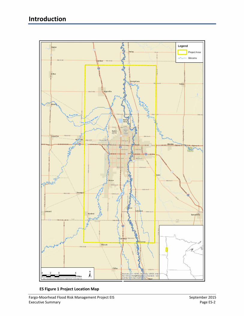
1 The Flood Diversion Board of Authority (Diversion Authority) is proposing to construct the Fargo-Moorhead Flood Risk Management Project (Project) with an estimated cost of $1.8 billion (October 2011 dollars). The Project is an approximately 30-mile long diversion channel on the North Dakota side of the Fargo-Moorhead (F-M) urban area (cities of Fargo, Moorhead, and surrounding high-population density cities), including a 6-mile long connecting channel and tieback embankment with control structures on the Wild Rice River and Red River. The Project also consists of environmental mitigation projects, which would be located inside and outside the project area (ES Figure 1). When operated, the Project would divert a portion of the Red River flow upstream of the F-M urban area, intercept flow at the Wild Rice, Sheyenne, Maple, Lower Rush and Rush Rivers, and return it to the Red River downstream of the F-M urban area. Project operation would result in an approximately 32,000-acre upstream staging area. Because the Project includes the construction of a Class I dam (i.e., embankment system and control structures), an environmental impact statement (EIS) is required under Minnesota Rules, part 4410.4400, subpart 18.
This Executive Summary (ES) describes the process of developing the Environmental Impact Statement (EIS), including other alternatives to the Project that were considered based on evaluation criteria, environmental analysis, and in accordance with Minnesota Rules, part 4410.2300. The ES provides an overview of the Project, its alternatives, potential effects on the environment, and mitigation and monitoring measures proposed or recommended to minimize potential environmental impacts.
Introduction
Fargo-Moorhead Flood Risk Management Project EIS September 2015 Executive Summary Page ES-2
ES Figure 1 Project Location Map

Environmental Review Process
Fargo-Moorhead Flood Risk Management Project EIS September 2015 Executive Summary Page ES-3
ES Diagram 1 Environmental Impact Statement Process
Minimum 30-Day Public Comment
Period
Fargo-Moorhead Flood Risk Management Project General Environmental Impact Statement Process
Draft EIS September 2015
Notice of Intent
Determination of Adequacy
Minimum 30-Day Public Comment
Period
Minimum 30-Day Public Comment
Period
Scoping Process April 2013 - Feb. 2014
Final EIS TBD
What is the need for this Environmental Impact Statement?
An EIS is mandatory for the Fargo-Moorhead Flood Risk Reduction Project (Project) pursuant to Minnesota Rules, part 4410.4400, subpart 18, which requires preparation of an EIS for construction of a Class I dam. The control structures and embankment features of the Project meet the definition of a Class I dam under Minnesota Dam Safety program rules (Minnesota Rules, part 6115.0340). Any embankment upstream of the control structure that is at or below the elevation of the top of the dam and impounds water due to the presence of the control structure would be considered to be part of the dam.
The Minnesota Department of Natural Resources (MNDNR), as the Responsible Governmental Unit (RGU), has prepared an EIS to evaluate the proposed project in accordance with the Minnesota Environmental Policy Act (MEPA), Minnesota Statutes, section 116D. This EIS was developed to meet applicable requirements of Minnesota Rules, part 4410 (Environmental Quality Board; Environmental Review Program) that govern Environmental Review in Minnesota.
The purpose of an EIS is to:
• Evaluate the project’s potentiallysignificant environmental effects;
• Consider reasonable alternatives;• Explore mitigation measures for
reducing adverse effects;• Provide information to the public
and project decision-makers; and• To aid in making permit decisions.
The EIS is intended to provide information to units of government on the environmental impacts of a proposed project before approvals or necessary permits decisions are made and to identify measures necessary to avoid, reduce, or mitigate adverse environmental effects. The EIS is not a means to approve or disapprove a project; however, the EIS needs to be completed and determined to be adequate prior to permit approvals.
Minnesota Rules require that an EIS include at least one alternative of each of the following types, or provide an explanation of why no alternative is included in the EIS (Minnesota Rules, part 4410.2300, subpart G): alternative sites, alternative technologies, modified designs or layouts, modified scale or magnitude, and alternatives incorporating reasonable mitigation measures identified

Environmental Review Process
Fargo-Moorhead Flood Risk Management Project EIS September 2015 Executive Summary Page ES-4
through public comments. The alternative of no action is also required to be addressed in the EIS. The Project alternatives are evaluated in the EIS.
What is the public’s role in this environmental review process?
Public comment periods are included as part of the EIS process that allow public and local governments the opportunity to participate in the EIS process. This Draft EIS was published and circulated in accordance with the rules and requirements of Minnesota Rules (EQB Rules), part 4410. Citizens, organizations, tribal entities, and government entities are given a comment period (slightly over 30 days) in which to submit written comments on the Fargo-Moorhead Flood Risk Management Project DEIS. Additionally, a public meeting will be held on in Moorhead, Minnesota on October 14, 2015 to present information on the Draft EIS, answer questions, and provide a forum for oral and written public comments. Substantive comments received will be taken into account in assessing potential project impacts and potential mitigation for the EIS. Responses to substantive comments will be prepared and included in the Final EIS. The MNDNR will receive comments on the adequacy of the EIS during a second 10-day public comment period, after which, the MNDNR will make a determination of EIS adequacy.
Environmental Impact Statement Development
MNDNR, as the Responsible Governmental Unit (RGU), developed and prepared this EIS, which evaluated the Project in accordance with the Minnesota Environmental Policy Act (MEPA) (Minnesota Statutes, section 116D), and the rules governing the environmental review process, included in Minnesota Administrative Rules, part 4410. Utilization of the existing federally prepared environmental review documents was done as required by Minnesota Rules, part 4410.3900, subpart 3, which allows for the substitution of federal documents for state environmental review documents, insofar as the applicable documents satisfy the state level environmental review information needs as established through Minnesota Rules, part 4410 and the EIS scoping process.
In July 2011 the USACE, with cooperation from the City of Fargo and the City of Moorhead (non-Federal sponsors), issued a Final Feasibility Report and Environmental Impact Statement (FFREIS) for the Project. The USACE’s Record of Decision (ROD) was issued in April 2012. The USACE designated the Locally Preferred Plan (LPP) as its Selected Plan, or Federally Recommended Plan. The MNDNR submitted comments on the federal Draft EIS, federal Supplemental Draft EIS and the FFREIS.
In April 2013, the MNDNR issued the Scoping Environmental Assessment Worksheet (SEAW) and Draft Scoping Decision Document (DSDD) for the Project (ES Diagram 1). Public review of and comment on the Scoping EAW and DSDD was conducted in accordance with Minnesota Rules, part 4410.2100. The scoping documents were made available for public comment from April 15 to May 15, 2013, with a notice of availability in the April 15, 2013, EQB Monitor. A public information meeting was held in Moorhead on May 8, 2013. The comments received during the scoping period were considered in making revisions to the DSDD prior to the MNDNR issuing the Final Scoping Decision Document (FSDD) on February 2014.
What is the Final Scoping Decision Document?
The FSDD serves as the “blueprint” for preparing the EIS for the Project. The FSDD defines what topics have been adequately addressed in previous reviews and those that will be included for further analysis

Environmental Review Process
Fargo-Moorhead Flood Risk Management Project EIS September 2015 Executive Summary Page ES-5
in the EIS. Topics carried forward in the EIS include those that require additional information but are not likely to be significantly impacted and those topics that have the potential to be significantly impacted.
In preparing the FSDD, the MNDNR considered all substantive comments received during the scoping period to develop the FSDD. Information in the federal Supplemental EA was also incorporated as applicable as well as any supplemental data or data updates provided from the Project Proposer so that potential environmental and socioeconomic affects that were identified in the SEAW and DSDD were described in greater detail in the FSDD. To determine which topics should be included for further analysis in the EIS, potential issues from the state scoping process were reviewed and compared to the FFREIS to determine which, if any, additional scoped issues required further evaluation.
Topics Adequately Analyzed in Previous Documents The following topics were considered to be adequately analyzed in the FFREIS, Supplemental EA and the MNDNR’s Scoping EAW, including documentation submitted by the project proposer or the USACE after the USACE Record of Decision. Either the topic is not relevant or the potential impact so minor that it will not be addressed in the EIS, or the topic is significant but the FFREIS adequately addresses the Projects potential impacts.
• Water surface use• Vehicle related air emissions• Stationary source air emissions• Water use• Erosion and sedimentation from
construction activities• Water quality: surface water runoff
• Water quality: wastewaters• Geological hazards and soil conditions• Solid wastes, hazardous wastes,
storage tanks• Traffic• Odors, noise and dust• Visual impacts
No Significant Impacts Expected The MNDNR determined that the following topics are not expected to present potentially significant impacts, but would be addressed in the EIS using information beyond that in the FFREIS, Supplemental EA, and Scoping EAW. These topics include:
• Potential environmental hazards dueto past site uses
• Cover types• Fish passage and biological
connectivity• State listed species and special status
species
• Wildlife resources• Cultural resources• Project Hydrology• Socioeconomics Analysis• Dam Safety
Potentially Significant Impacts The MNDNR identified the following topics in the FSDD that may result in potentially significant impacts and therefore, this EIS will provide additional information beyond what was previously provided in the FFREIS, Supplemental EA, and Scoping EAW:
• Stream stability• Wetlands• Cold weather impacts on aqueduct function and biotics• FEMA regulations and the CLOMR process

Environmental Impact Statement Participants/Preparers
Fargo-Moorhead Flood Risk Management Project EIS September 2015 Executive Summary Page ES-6
The Project Team is comprised of the MNDNR, Diversion Authority, and USACE. The MNDNR served as the lead agency in preparing the EIS and facilitating the state EIS process.
The Project Team
A project team was established early on in the environmental review process. The Project Team is comprised of the MNDNR, Diversion Authority, and USACE. The intent of the Project Team was to provide a coordinated effort between the entities in gathering, reviewing, preparing, and disseminating data and information during the state environmental review process. The MNDNR served as the RGU in preparing the EIS and facilitating the state EIS process. The Diversion Authority and USACE provided data and information to help inform the EIS. The Project Team reviewed and commented on data and analyses, EIS evaluations, and draft versions of the EIS document prior to publication and formal public review.
The Project Team also provided a direct line of communication between the entities, who met on a regular basis throughout the environmental review process. This collaboration allowed for issue discussion and regular exchange of data and information.
The Project Proposer
The Project Proposer is the Diversion Authority. The USACE has partnered with the Diversion Authority to plan, secure funding for, and construct the Project. Operation and future maintenance of the Project would be the responsibility of the Diversion Authority and/or other potential non-Federal sponsors.
The Diversion Authority was created by a joint powers agreement between the Cities of Fargo, North Dakota and Moorhead, Minnesota, along with Cass County, North Dakota, Clay County, Minnesota, the Cass County Joint Water Resources District, and the Buffalo-Red River Watershed District effective July 11, 2011. The Diversion Authority is led by nine board members from the stakeholder entities. The purpose of the Diversion Authority is to build and operate a flood diversion channel along the Red River to reduce the flood risk of the stakeholder communities and counties. Additional information on the Diversion Authority is available on their website: www.fmdiversion.com.
The Non-Federal Sponsor
Prior to formation of the Diversion Authority, the USACE was brought in by the Cities of Fargo and Moorhead to help them determine what could be done to reduce flood risk in the metropolitan area. Together, they worked to create the Fargo-Moorhead Metro Flood Risk Management Feasibility Study (Feasibility Study) to develop the flood diversion channel project. In order to further advance the diversion channel concept, the Cities officially partnered with USACE as a non-Federal sponsor and proceeded with federal environmental review.

Environmental Impact Statement Participants/Preparers
Fargo-Moorhead Flood Risk Management Project EIS September 2015 Executive Summary Page ES-7
The Diversion Authority should not be confused with "local sponsor," which is synonymous with "non-Federal sponsor." The USACE defines the non-Federal sponsor as 1) a legally constituted public body (including a federally recognized Indian tribe); or 2) a nonprofit entity with the consent of the affected local government that has full authority and capability to perform the terms of its agreement and to pay damages, if necessary, in the event of failure to perform. Fargo and Moorhead were the two non-Federal sponsors during the Project feasibility study and for the original Design Agreement (executed September 12, 2011). A Design Agreement Amendment #1 was executed on December 19, 2013 which added the Diversion Authority as a non-Federal sponsor. Thus, as of the production of the EIS, the non-Federal sponsors are considered the City of Moorhead, City of Fargo, and the Diversion Authority.

Description of the Proposed Project
Fargo-Moorhead Flood Risk Management Project EIS September 2015 Executive Summary Page ES-9
The purpose of the Project is to reduce flood risk potential on local streams, qualify substantial portions of the F-M urban area for 100-year flood accreditation, and reduce flood risk for floods exceeding the 100-year flood or greater.
What is the purpose and need of the Project?
The following purpose and need statement were developed by the Diversion Authority to meet the needs of the state environmental review process and are not the same as those used in the FFREIS. The purpose of the Project is to reduce flood risk, flood damages, and flood protection costs related to flooding in the F-M Metropolitan area. To the extent technically and fiscally feasible, the Project will:
1. Reduce flood risk potentialassociated with a long history of frequent flooding on local streams including the Red River, Sheyenne, Wild Rice (North Dakota), Maple, Rush and Lower Rush Rivers passing through or into the F-M metropolitan area,
2. Qualify substantial portions of the F-M metropolitan area for 1-percent chance flood (i.e.,100-year flood) accreditation (i.e., meets the standard to be shown on Flood Insurance RateMaps as providing protection) by the Federal Emergency Management Agency (FEMA)under the National Flood Insurance Program; and
3. Reduce flood risk for floods exceeding the 100-year flood or greater, given the importanceof the F-M metropolitan area to the region and recent frequencies of potentiallycatastrophic flood events.
The need for the Project is due to the high risk of flooding in the F-M metropolitan area. The Red River, Wild Rice River, Sheyenne River, Maple River, Lower Rush River, and the Rush River all contribute to the flood risk. Average annual national economic flood damages in the F-M metropolitan area are estimated to be more than $51 million. Flooding in the F-M area typically occurs in late March and early April as a result of spring snowmelt. Flooding poses a significant risk of damage to urban and rural infrastructure and disrupts transportation throughout the metropolitan area. The F-M urban area is a regional center for healthcare, education, government, and commerce. Infrastructure at risk in the F-M urban area includes several regional medical centers, three college campuses, and city and county government offices.
The Red River has exceeded the National Weather Service flood stage of 18 feet at the United States Geological Survey (USGS) gage in Fargo (Fargo gage) in 50 of the past 114 years (1902 through 2015), and recently every year except 2012 from 1993 through 2013. The record-setting Red River flood stage in 2009 at Fargo was 40.82 feet on the Fargo gage. The hydrologic record of the Red River shows a trend of increasing magnitude and frequency of flooding in recent decades.
What is the Proposed Project?
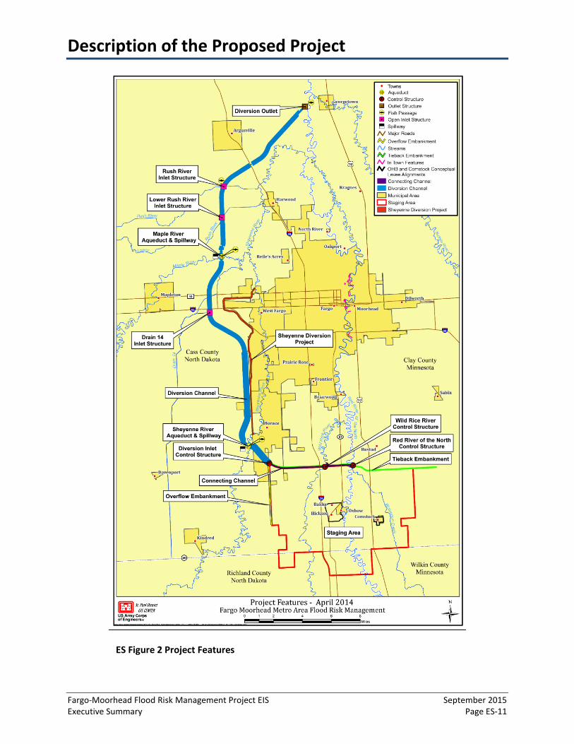
The Project would be located in the F-M area, within an area approximately 12 miles west to six miles east of the Red River and from 20 miles north to 20 miles south of Interstate 94. The Project consists of a dam and diversion channel system (ES Figure 2) including, but not limited to: a tieback embankment and overflow embankment; control structures on the Red River and Wild Rice River; excavated channels; a diversion inlet control structure; aqueducts on the Maple and Sheyenne Rivers; an upstream flood water staging area (staging area); inlet structures on tributaries; the Oxbow, Hickson, Bakke (OHB) ring levee; the Comstock ring levee; levees and floodwalls in the F-M urban area; non-structural features

Description of the Proposed Project
Fargo-Moorhead Flood Risk Management Project EIS September 2015 Executive Summary Page ES-10
The Project would create a 30-mile long diversion channel on the west side of the Fargo-Moorhead urban area with a tieback embankment and control structures spanning the Wild Rice River and Red River. Project operation would divert a portion of water flow from upstream rivers and streams into the channel, while creating a staging area upstream of the embankment.
(such as buyout, relocation, or raising individual structures); and recreation features (such as multipurpose trails and pedestrian bridges). The Project also consists of environmental mitigation projects, which would be located inside and outside the project area.
The tieback embankment would extend from high ground in Minnesota to high ground in North Dakota and would be constructed to connect the Red River, Wild Rice River, and diversion inlet control structures. The tieback embankment and control structures would impound water in the inundation areas and meet the definition of a Class I dam under Minnesota Rules, part 4410.4400, subpart 18. The dam would be designed to meet USACE dam safety standards.
As proposed, the Project would create a 30-mile long diversion channel on the North Dakota side of the F-M area. There would be a 6-mile long connecting channel between the Red River and the diversioninlet control structure. When operated, the Project would divert a portion of the Red River flowupstream of the F-M urban area, intercept flow at the Wild Rice, Sheyenne, Maple, Lower Rush andRush Rivers, and return it to the Red River downstream of the F-M urban area.
Operation of the Project would occur when it becomes known that a stage of 35.0 feet would be exceeded at the Fargo gage. At this stage, the flow through Fargo would be approximately 17,000 cubic feet per second (cfs). A flow of 17,000 cfs at the Fargo gage is approximately a 10-percent chance flood (10-year flood). Operation begins by partially closing the gates at the Red River and Wild Rice River control structures. Once the gates are partially closed, water would begin to accumulate in the inundation areas, south of the tieback embankment. Water would not be released through the diversion inlet control structure gates until the Red River and Wild Rice River control structures are partially closed. The diversion inlet control structure gates would be opened only after the initial diversion tributary (Sheyenne River, Maple River, Lower Rush River, and Rush River) flow peaks have made it to the diversion.
The Project would be federally-sponsored and would be designed and constructed to federal standards. The Project would be owned and operated by the non-Federal sponsors. Project operation, maintenance, and monitoring would be the responsibility of the non-Federal sponsors. With continual, sufficient funding, construction is expected to take a minimum of eight and one half years.
Description of the Proposed Project
Fargo-Moorhead Flood Risk Management Project EIS September 2015 Executive Summary Page ES-11
ES Figure 2 Project Features
Description of the Proposed Project
Fargo-Moorhead Flood Risk Management Project EIS September 2015 Executive Summary Page ES-12
The Project would reduce flood damages and flood risk in the F-M urban area, but it would not completely eliminate flood risk. The Project would reduce flood stages on the Red River in the cities of Fargo and Moorhead and would also reduce stages on the Wild Rice, Sheyenne, Maple, Rush and Lower Rush Rivers between the Red River and the diversion channel. With the Project operational, the stage from a 100-year flood on the Red River would be reduced from approximately 42.1 feet (assuming emergency levees confine the flow) to 35.0 feet at the Fargo gage. The following provides a description of the Project components.
Dam The dam includes the three control structures (i.e., Red River, Wild Rice, and Diversion Inlet) and embankments. The control structures are gated structures that span the river to control the flow of water downstream. The embankments are raised structures constructed of soil and include the tieback embankment and the overflow embankment.
The length of dam between high ground in Minnesota to the diversion inlet control structure would be approximately 12 miles (six miles in Minnesota and six miles in North Dakota) and would be generally in an east/west direction. A four-mile long overflow embankment would be built south of the diversion inlet control structure along Cass County Highway 17 (a north/south configuration). This portion of the dam would act as an emergency spillway for extreme events that exceed the 0.2-percent chance (i.e., 500-year flood) design capacity of the Project.
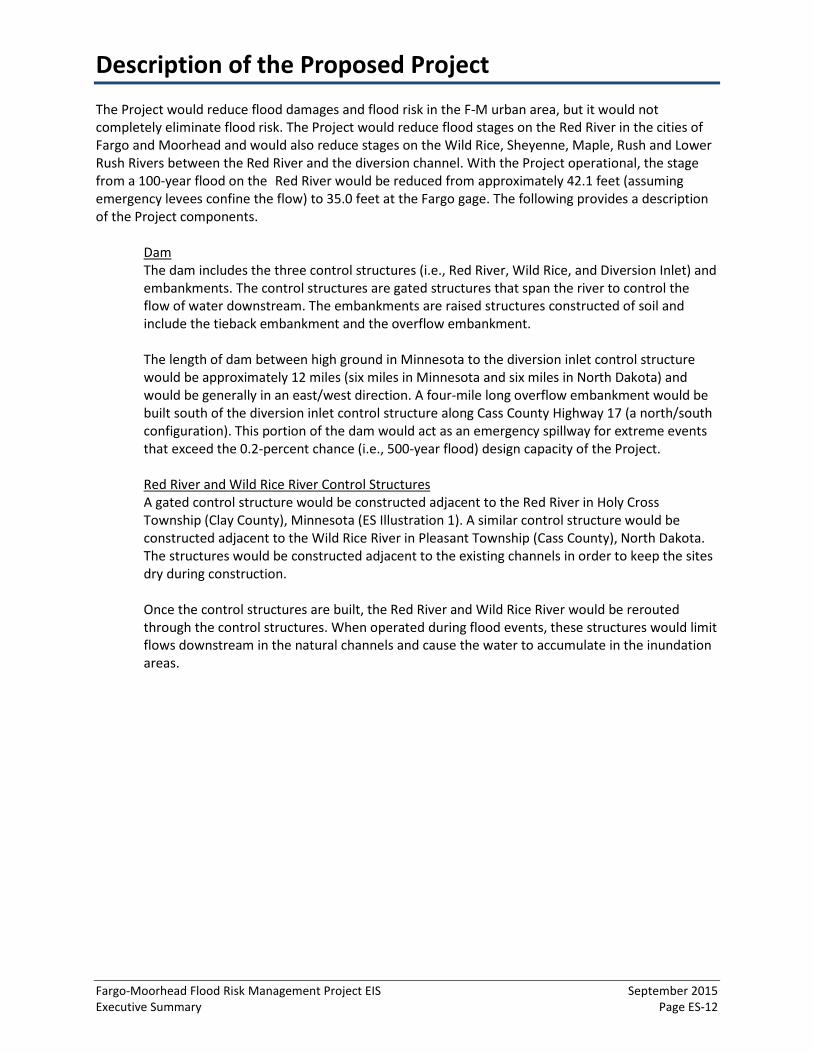
Red River and Wild Rice River Control Structures A gated control structure would be constructed adjacent to the Red River in Holy Cross Township (Clay County), Minnesota (ES Illustration 1). A similar control structure would be constructed adjacent to the Wild Rice River in Pleasant Township (Cass County), North Dakota. The structures would be constructed adjacent to the existing channels in order to keep the sites dry during construction.
Once the control structures are built, the Red River and Wild Rice River would be rerouted through the control structures. When operated during flood events, these structures would limit flows downstream in the natural channels and cause the water to accumulate in the inundation areas.
Description of the Proposed Project
Fargo-Moorhead Flood Risk Management Project EIS September 2015 Executive Summary Page ES-13
ES Illustration 1 Control Structure Design for the Red River
Source: Diversion Authority, 2015
Connecting Channel The Project would include a six mile long connecting channel between the Red River and the diversion inlet control structure. The connecting channel bottom width is approximately 100 feet and would slope toward the Wild Rice and Red Rivers to drain the inundated areas when flood flows have receded.
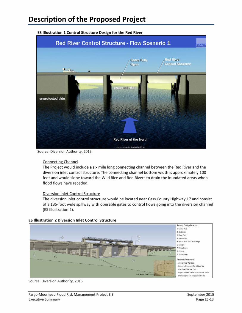
Diversion Inlet Control Structure The diversion inlet control structure would be located near Cass County Highway 17 and consist of a 135-foot wide spillway with operable gates to control flows going into the diversion channel (ES Illustration 2).
ES Illustration 2 Diversion Inlet Control Structure
Source: Diversion Authority, 2015
Description of the Proposed Project
Fargo-Moorhead Flood Risk Management Project EIS September 2015 Executive Summary Page ES-14
Staging Area Based on the estimated depth and duration of a 500-year flood, 225,000 acre-feet or 32,000 acres are required for staging water before directing it to the connecting channel. This required area is generally referred to as the staging area. Water would begin to pool and inundate behind the dam when the Red and Wild Rice River control structure gates are partially closed to limit flows through the F-M urban area. Red River and Wild Rice River control structures would be operated to raise water surface elevations to approximately 922.2 feet (North American Vertical Datum (NAVD) 88) at the diversion inlet for all events up to a 500-year flood. The staging area would be regulated so that the required volume is maintained.
All of the fringes of the inundated area within the staging area would experience additional flood depths of zero to one foot, while the majority of the land within the staging area would see additional depths greater than one foot. There are some areas within the staging area that would not become inundated during Project operation. In contrast, there are areas outside of the staging area that would become newly inundated or would experience additional depths of flooding as a result of Project operation. The majority of these inundated areas outside the staging area boundary would experience less than one foot of additional flood depth and are not considered as part of the required volume. The term “staging area” is used when referring to a Project component as in discussing where mitigation applies. The term “inundation area(s)” is used to describe any land that becomes flooded, regardless of depth. “Inundation area” is not tied to use with any specific flood event or to the Project or Project alternatives.
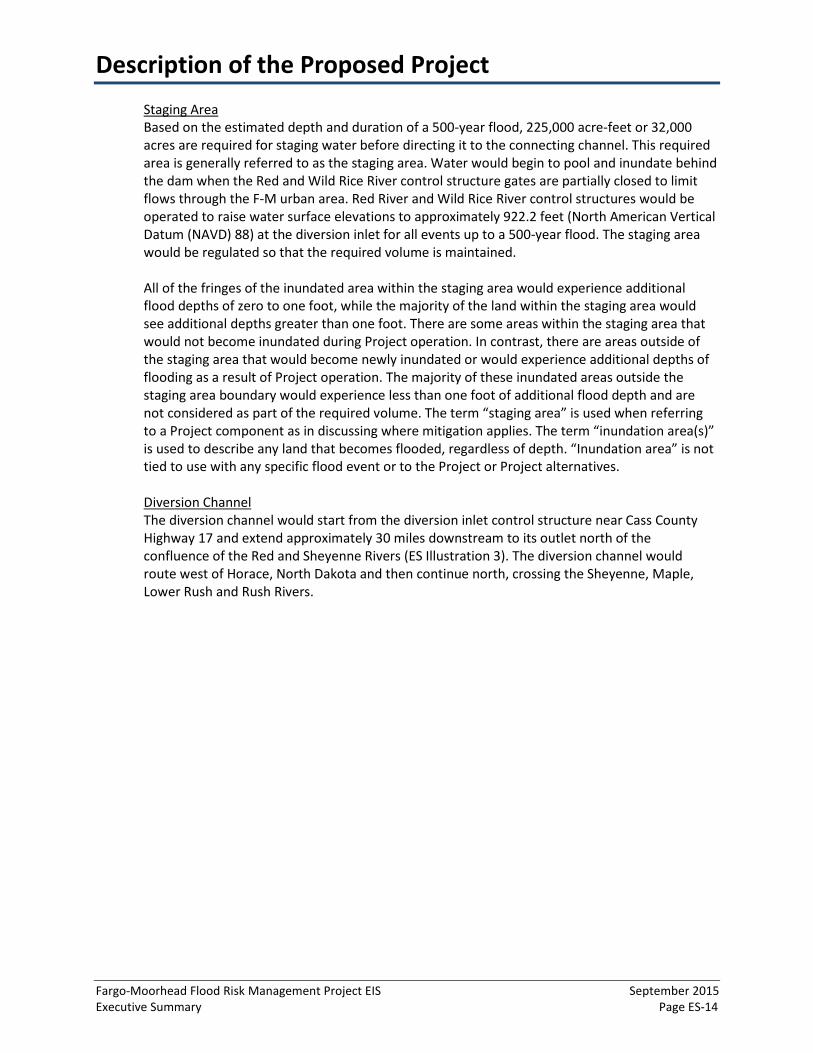
Diversion Channel The diversion channel would start from the diversion inlet control structure near Cass County Highway 17 and extend approximately 30 miles downstream to its outlet north of the confluence of the Red and Sheyenne Rivers (ES Illustration 3). The diversion channel would route west of Horace, North Dakota and then continue north, crossing the Sheyenne, Maple, Lower Rush and Rush Rivers.
Description of the Proposed Project
Fargo-Moorhead Flood Risk Management Project EIS September 2015 Executive Summary Page ES-15
ES Illustration 3 Diversion Channel Design
Source: Diversion Authority, 2015
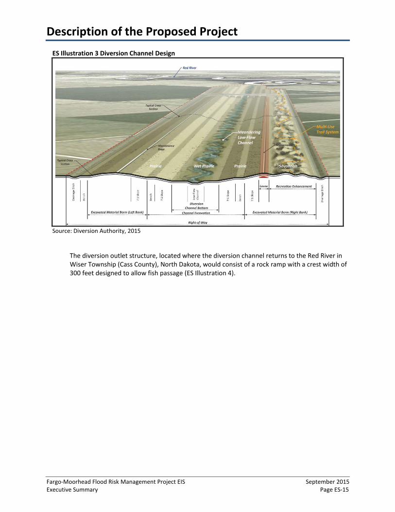
The diversion outlet structure, located where the diversion channel returns to the Red River in Wiser Township (Cass County), North Dakota, would consist of a rock ramp with a crest width of 300 feet designed to allow fish passage (ES Illustration 4).

Description of the Proposed Project
Fargo-Moorhead Flood Risk Management Project EIS September 2015 Executive Summary Page ES-16
ES Illustration 4 Diversion Outlet Structure
Source: Diversion Authority, 2015
The diversion channel is designed to receive 20,000 cfs for the 100-year flood at the diversion inlet control structure and additional water from drainages intersected downstream of the inlet control structure. The diversion is designed to keep the 100-year flood flows below existing ground elevations as much as practicable to limit impacts to drainage outside the channel. The diversion channel would have a bottom width of 300 feet and a variable-width, low-flow channel that has been sized based on sediment transport considerations (ES Illustration 5). The low-flow channel would meander within a 200-foot belt width within the 300-foot bottom width from just upstream of the diversion channel outlet to just downstream of the Maple River aqueduct. The meandering portion of the low-flow channel would also serve as a way of substituting for the aquatic habitat lost due to the diversion channel construction in the Lower Rush and Rush River channels between the diversion channel and the Sheyenne River.
ES Illustration 5 Diversion Channel Cross Section
Source: Diversion Authority, 2015

Description of the Proposed Project
Fargo-Moorhead Flood Risk Management Project EIS September 2015 Executive Summary Page ES-17
The depth of the diversion channel would range from 15 to 25 feet deep excluding the low-flow channel and 20 to 30 feet deep including the low-flow channel. The side slopes away from the 300-foot bottom width and would be one vertical step to seven horizontal steps. This includesgeotechnical “benches” of 0 to 30 feet wide, as needed, to provide additional stability to meetthe required factors of safety.
Soil excavated from the diversion channel would be placed into excavated material berms adjacent to the channel to a typical height of 16 feet. The excavated material berms would be as wide as necessary to contain the excavated material. Portions of the berms on the east side of the channel would be constructed to serve as levees when the water surface in the channel is higher than the natural grade. The maximum width of the footprint along the diversion channel would be approximately one half mile including the diversion channel and excavated material berms.
Drainage ditches adjacent to the berms would be necessary to intercept local drainage and direct it to the nearest downstream diversion inlet control structure. The drainage ditches would run along the exterior excavated material berm toe on both sides of the diversion channel.
Maple River and Sheyenne River Aqueducts Aqueducts (bridge-like structures that convey water over the diversion channel) would be constructed for the Maple River and Sheyenne River (ES Illustration 6) that would allow for the continuous connectivity of these two rivers.
ES Illustration 6 Maple and Sheyenne Rivers Aqueduct Design
Source: Diversion Authority, 2015
During flood events, fixed-crest weir spillways would direct flood flows into the diversion channel and allow for flows in the diversion channel to pass underneath the aqueducts while allowing the existing river bankfull flows (i.e., flows at which water fills the channel without overtopping the banks – on average recurrence is 1.5 years in Minnesota) to continue downstream. The intent of the Sheyenne and Maple River aqueducts, as planned and operated, would be to maintain biological connectivity and fish passage in the rivers. The two aqueducts are similar in concept; each includes a grade control structure to prevent headcutting on the
Description of the Proposed Project
Fargo-Moorhead Flood Risk Management Project EIS September 2015 Executive Summary Page ES-18
tributary, an inlet structure to control diversion of tributary flows, heating components for cold weather operation, and an aqueduct to pass a limited flow over the diversion channel to maintain the desired downstream flow. The aqueducts would be constructed off-channel with the river diverted across the aqueduct upon completion.
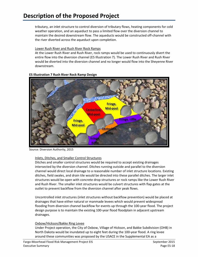
Lower Rush River and Rush River Rock Ramps At the Lower Rush River and Rush River, rock ramps would be used to continuously divert the entire flow into the diversion channel (ES Illustration 7). The Lower Rush River and Rush River would be diverted into the diversion channel and no longer would flow into the Sheyenne River downstream.
ES Illustration 7 Rush River Rock Ramp Design
Source: Diversion Authority, 2015
Inlets, Ditches, and Smaller Control Structures Ditches and smaller control structures would be required to accept existing drainages intersected by the diversion channel. Ditches running outside and parallel to the diversion channel would direct local drainage to a reasonable number of inlet structure locations. Existing ditches, field swales, and drain tile would be directed into these parallel ditches. The larger inlet structures would be open with concrete drop structures or rock ramps like the Lower Rush River and Rush River. The smaller inlet structures would be culvert structures with flap gates at the outlet to prevent backflow from the diversion channel after peak flows.
Uncontrolled inlet structures (inlet structures without backflow prevention) would be placed at drainages that have either natural or manmade levees which would prevent widespread flooding from diversion channel backflow for events up through the 100-year flood. The project design purpose is to maintain the existing 100-year flood floodplain in adjacent upstream drainages.
Oxbow/Hickson/Bakke Ring Levee Under Project operation, the City of Oxbow, Village of Hickson, and Bakke Subdivision (OHB) in North Dakota would be inundated up to eight feet during the 100-year flood. A ring levee around these communities was proposed by the USACE in the Supplemental EA as a

Description of the Proposed Project
Fargo-Moorhead Flood Risk Management Project EIS September 2015 Executive Summary Page ES-19
modification to the Project to address these impacts. The OHB ring levee would be constructed to the Project operation elevation for the 100-year flood plus four feet of freeboard (ES Figure 3). OHB ring levee construction requires roadway modifications. The existing sanitary sewer system, water main, and storm sewer system would be modified to accommodate the ring levee and new residential areas.
Source: HMG, 2015
ES Figure 3 Oxbow/Hickson/Bakke Ring Levee Design
Comstock Ring Levee A ring levee would be also constructed around the city of Comstock, Minnesota, which under existing conditions, is located outside of the 100-year floodplain. Operation of the Project would
Description of the Proposed Project
Fargo-Moorhead Flood Risk Management Project EIS September 2015 Executive Summary Page ES-20
cause new inundation in this community during and above the 100-year flood. The design of the Comstock Ring Levee is conceptual at this time. The details that follow are subject to revision pending further design and coordination between the Diversion Authority and the City of Comstock. Clay County Highway 2 would be raised at both places where it crosses the ring levee. The BNSF Moorhead Subdivision Rail Line on the north and south side would require protection measures above a 100-year flood.
Transportation and Utility Modifications Interstate 29, U.S. Highway 75, and the BNSF Hillsboro Subdivision Rail Line near U.S. Highway 75 would be raised slightly above the 500-year flood elevation to maintain access during flood inundation. Other roads within the inundation areas, except OHB and Comstock ring levee access roads, would be allowed to flood when the Project operates. Utilities located in the inundation area would be evaluated during final Project design. Known utilities include, but are not limited to, electric power lines, rural water supply, and sewer facilities. Utilities that cannot withstand occasional flooding would be abandoned, modified or relocated, depending on the situation in accordance with applicable regulations.
Along the length of the diversion channel, 19 road crossings, including four railroad bridges, and highway relocations would occur at approximately three mile intervals, primarily for county roads. Other roads may be terminated at the diversion channel or rerouted to the local road network, which would be determined during final Project design. The four new railroad bridges would be needed where existing railroads intersect the diversion channel.
Project Operation The gates at the Red River and Wild Rice River control structures would be fully open and the gates at the diversion inlet control structure would be fully closed when the Project is not operating. The decision as to whether the Project will begin to operate or not would be based on measurements at the USGS gages in Fargo, Enloe and Abercrombie. Project operation would start if the Fargo gage stage would exceed 35.0 feet of water which corresponds to a flow of 17,000 cfs. A flow of 17,000 cfs at the Fargo gage is approximately a 10-percent annual exceedance probability event using the updated (EOEP) hydrology. The MNDNR utilized the recommendations of the EOEP in the EIS. Unless mentioned otherwise, all discussions in the EIS use EOEP hydrology. Similarly, all elevations are relative to NAVD 88, unless noted.
Operation would begin with partially closing the gates at the Red River and Wild Rice River control structures. Once the gates are partially closed (i.e., partially lowered), water would begin to accumulate upstream of the control structures. Water would not be released through the diversion inlet control structure gates until the Red River and Wild Rice River control structures are partially closed.
Project operation on the rising limb of the flood hydrograph (i.e., flood discharges are increasing) is based on minimizing downstream impacts, and therefore, the diversion inlet control structure gates would be opened only after the initial diversion tributary (Sheyenne River, Maple River, Lower Rush River, and Rush River) flow peaks have made it to the diversion. Project operation on the falling limb of the flood hydrograph (i.e., flood discharges are decreasing) is based on minimizing the duration of upstream impacts without causing upstream stages to fall faster than what has been experienced during historic floods. If the staging area elevations drop too quickly, it could cause environmental concerns (e.g., fish stranding and streambank instability).

Description of the Proposed Project
Fargo-Moorhead Flood Risk Management Project EIS September 2015 Executive Summary Page ES-21
Flood stages through the F-M urban area and upstream of the control structures would depend on the peak discharge from the Red River and Wild Rice River hydrographs. As long as it is clear that 34,700 cfs would not be exceeded, the Fargo gage stage would be limited to 35.0 feet, the maximum flow allowed through the diversion inlet control structure would be 20,000 cfs, and there would be a maximum elevation of 922.2 feet in the staging area just upstream of the control structures
If the forecasted peak flow at Fargo is greater than 34,700 cfs, the target stage at the Fargo gage would be increased from 35.0 feet up to 40.0 feet, depending on the flood forecast. Emergency flood fighting measures are required once the target stage is increased above 35.0 feet. The maximum target stage of 40.0 feet is comparable to the stage experienced during the 2009 flood. Since this operating procedure allows more flow to be passed through town (resulting in the higher stages), it allows the staging area to crest at 922.2 feet for 100-year through 500-year events. The maximum flow allowed through the diversion inlet control structure would be 20,000 cfs up through the 500-year flood.
For events greater than a 500-year flood, a stage of 40.0 feet would be maintained at the Fargo gage and the staging area elevation would be allowed to rise above 922.2 feet. The rise of the staging area would be minimized as much as possible by further opening the diversion inlet control structure gates to allow more flow into the diversion. At the point of minimum acceptable freeboard, flow out of the staging area would be maximized at the diversion inlet structure and over the overflow embankment along the west side of the staging area. Flow exiting the staging area via the overflow embankment would flow overland into the Sheyenne River basin.
An evacuation order would be issued for the F-M urban area as the staging area elevation approaches the minimum acceptable freeboard level. Once the upstream staging elevation reaches the point of minimum acceptable freeboard, the Red River and Wild Rice River control structure gates would be opened further to maintain the minimum freeboard and stages would rise above 40.0 feet at the Fargo gage.
The non-Federal sponsors would be responsible for all operations, maintenance, repair, rehabilitation and replacement (OMRR&R) of the Project. The cost share agreement between the USACE and the non-Federal sponsors requires the non-Federal sponsors to operate the Project in accordance with the Operation, Maintenance, Repair, Replacement, and Rehabilitation (OMRR&R) Manual to be prepared by the USACE.
Floodwalls and In-Town Levees The Project would include floodwalls and levees in Fargo and Moorhead, which would allow more flows to pass through town and reduce Project operation frequency. The in-town levees would be such that FEMA would be able to accredit the levees for the 100-year flood once the Project is complete.

Description of the Proposed Project
Fargo-Moorhead Flood Risk Management Project EIS September 2015 Executive Summary Page ES-22
Non-structural Project features include fee acquisitions, construction of ring levees, and acquisition of flowage easements. Each property would be analyzed throughout the inundation area to determine appropriate mitigation, including a takings analysis as needed.
Non-structural Project Features There are several non-structural mitigation measures included in the Project to address impacts of increased flooding within the inundation area. These consist of fee acquisitions or relocations, construction of accredited ring levees and the acquisition of flowage easements. The April 2015 FEMA/USACE Coordination Plan states that all impacts to insurable structures within the FEMA revision reach (i.e., where the Project would alter the Red River profile flood elevation by more than 0.5 feet) would be mitigated through agreed methods consistent with those specified by the National Flood Insurance Program based on the depth of flooding at each structure. In accordance with the FEMA/USACE Coordination Plan (April 2015) impacted homes, structures, and businesses that have greater than two feet of flooding for the 100-year flood with the Project would be purchased or relocated and those with up to two feet of flooding would be evaluated for non-structural measures such as accredited ring levees, relocation, or elevating structures. The FEMA revision reach includes the entire staging area as well as some areas upstream of the staging area.
The Coordination Plan requires that the areal extent of flood inundation required for operation of the Project within the staging area be mapped as floodway in order to ensure that the required volume is available for the Project during the 100-year flood. Flowage easements would be obtained for all floodway designated areas. Any additional flood inundation within the FEMA revision reach that is outside of the staging area would be mapped as floodplain in order to portray the elevated flood risk outside of the required staging area.
Areas outside the FEMA revision reach, such as those along the Red River, Wild Rice River and connected drainages may also be affected by Project operation. Inundation outside of the designated staging area is estimated to be less than one foot of additional flood depth for a 100-year flood and would be impacted by the Project primarily in the spring. It is anticipated that for agricultural lands in most areas, farming could continue without significant impacts. The USACE has proposed that a takings analysis on a case-by-case-basis would be performed to determine mitigation needs within this area. Flowage easements would be obtained for land and structures would be mitigated only where the taking analysis (See Chapter 3, Subsection 3.2 – FEMA Regulations and the CLOMR Process for more details on the taking analysis) determines impacts rise to the level of a taking under the Fifth Amendment of the U.S. Constitution1. This analysis would include evaluation of property impacts such as land value, water supply, and septic systems. Landowners would be compensated appropriately for any takings. Minnesota Rules, part 6120.5700, subpart A requires mitigation for existing insurable structures in Minnesota with any impact.
1The 5th Amendment of the US Constitution requires just compensation when private property is taken for public use. CFR 49 Part 24 - Uniform Relocation Assistance and Real Property Acquisition Policies Act of 1970, PL 91-646, as amended, details benefits to the property owner and/or displaced residential renters for Federal and Federally Assisted Programs.
Description of the Proposed Project
Fargo-Moorhead Flood Risk Management Project EIS September 2015 Executive Summary Page ES-23
Recreation Features The conceptual recreation plan for the Project includes one concrete multi-purpose trail and one aggregate equestrian trail loop with a combined length of approximately 47-miles. These trails are in addition to the aggregate maintenance road that is included in the Project. In addition to the proposed trail system, other activities have been identified and planned for in key locations. These locations are known as Activity Hubs, which would function as primary trail access locations as well as recreation destinations. While the individual hubs would vary in character, recreation features would include parking, restrooms, trail way-finding signage, picnic facilities, drinking water, interpretative signage, fishing, and boat access. Activity Nodes are similar to hubs but provide less intensive site-specific activities and could serve as secondary access points to the trails. Landscaping of trees and shrubs at the trailheads, Activity Hubs and Nodes are proposed along with trees, native prairie grasses and forbs along the trail. All proposed recreation facilities would meet the guidelines for Americans with Disabilities Act (ADA) and the Architectural Barriers Act (ABA).

Description of the No Action Alternative
Fargo-Moorhead Flood Risk Management Project EIS September 2015 Executive Summary Page ES-24
The No Action Alternatives provide the context for the potential environmental and socioeconomic effects that would occur if the Project is not developed. There are two No Action alternatives considered for the Project: 1) Base No Action Alternative; and 2) No Action Alternative (with Emergency Measures).
What are the No Action Alternatives?
Base No Action Alternative The Base No Action Alternative includes the potential flood risk reduction impact of already completed and currently funded projects such as levee construction and property buyouts and does not include the use of emergency measures.
No Action Alternative (with Emergency Measures) The No Action Alternative (with Emergency Measures) is similar to the Base No Action Alternative, but also acknowledges the emergency measures currently being pursued in the project area and assumes that those would continue to be implemented as necessary due to flooding. Emergency measures have lower reliability, higher risk for loss of life than permanent flood risk reduction features and cannot be certified or accredited by the USACE or FEMA, respectively; and therefore, are being discussed under a second No Action Alternative option. Emergency measures are intended to temporarily protect specific areas from flooding that do not have permanent flood damage reduction (FDR) projects in place or enhance existing FDR projects, where there are gaps in levee protection between each of the individual FDR projects, for example. Where gaps in FDR project protection exist, a temporary levee may be constructed to tie into existing levees to reduce flood risk from occurring behind the levee or overtopping an existing levee.
Permanent FDR projects are a key component to both the Base No Action Alternative and the No Action Alternative (with Emergency Measures). Since the 1997 flood, the Cities of Fargo and Moorhead have implemented flood risk reduction measures, including acquisition of floodplain houses, constructing levees and floodwalls, raising and stabilizing existing levees, installing permanent pump stations and improving storm sewer lift stations and the sanitary sewer system. FDR projects have been designed for protection at the current, effective FEMA 100-year flood. Because of the difference between the FEMA hydrology and the EOEP hydrology, some of the FDR projects are at elevations above the EOEP 100-year flood elevation, but do not have sufficient free board and/or tie-in elevations for FEMA accreditation under the EOEP hydrology. This means there could be actual protection, but not accredited protection under the EOEP hydrology. For the purposes of EIS analysis, non-accredited structures are considered as flooded for the Base No Action Alternative.
There are two No Action Alternatives considered for the Project: Base No Action and No Action (with Emergency Measures).

Alternatives Considered and Evaluated in the Environmental Impact Statement
Fargo-Moorhead Flood Risk Management Project EIS September 2015 Executive Summary Page ES-25
Pursuant to Minnesota Rules, part 4410.2300, subpart G, the EIS is required to include one or more alternatives of each of the following categories or provide a concise description of why no alternative in a particular category is included in the EIS.
• Alternative Sites• Alternative Technologies• Modified Designs or Layouts• Modified Scale or Magnitude• Alternatives that incorporate reasonable mitigation measures identified through the comment
periods for EIS scoping or for the Draft EIS.
The MNDNR conducted an independent assessment of potential projects within the above categories, considering the alternatives discussed in the FFREIS and combining other measures with those alternatives. As part of the scoping, the MNDNR prepared the Alternatives Screening Report: Fargo-Moorhead Metropolitan Area Flood Risk Management Project (December 2012) (Alternatives Screening Report).
Reasonable alternatives were considered for their relevance to meet the proposer’s defined Project purpose and need, as well as their feasibility to improve environmental and/or socioeconomic benefits, while reducing potential environmental impacts that may result. Alternative sites and alternative technologies were evaluated in the EIS. Other alternatives considered, but dismissed from further evaluation in the EIS, include modified designs and layouts, and modified scale and magnitude. Alternatives incorporating reasonable mitigation measures were also evaluated in the EIS for each topic area as it related to the mitigation.
An alternative may be excluded from analysis in the EIS if it does not meet the underlying need for or purpose of the project; it would likely not have significant environmental benefit compared to the project as proposed; or another alternative of any type that is analyzed in the EIS would likely have similar environmental benefits but substantially less adverse economic, employment, or sociological impacts (Minnesota Rules, part 4410.2300, subpart G).
Was an alternative site evaluated?
Minnesota Rules, part 4410 requires an evaluation of site location alternatives. Minnesota Rules, part 4410 allows the RGU to exclude alternative sites if other sites do not have significant environmental benefit compared to the project as proposed, or if other sites do not meet the underlying need and purpose of the Proposed Project. The Alternatives Screening Report determined that the reasonably available alternate diversion sites in Minnesota and/or North Dakota do not produce benefits for environmental resources or socioeconomic factors, and therefore the EIS will not evaluate alternative sites.
What alternative technologies were analyzed?
Six potential technology alternatives were studied in the Alternatives Screening Report. Two of these alternatives, tunneling and Interstate 29 Viaduct, had a similar effectiveness to the Project but did not present a significant environmental benefit. In addition, they are expected to transfer potential impacts
Alternatives Considered and Evaluated in the Environmental Impact Statement
Fargo-Moorhead Flood Risk Management Project EIS September 2015 Executive Summary Page ES-26
The Northern Alignment Alternative is a modified version of the Project design and layout, and was evaluated in the EIS.
of the Project downstream, and they have excessive capital costs, and therefore will not be evaluated in the EIS.
The remaining alternative technologies (non-structural measures; flood barriers; flood storage; and flood storage combined with a control structure) did not effectively meet the Project purpose by themselves. However, it was initially thought that a combination of these alternatives could potentially meet the Project purpose and present increased environmental benefit. Therefore the Distributed Storage Alternative, which is principally a modified design alternative that incorporates these alternative technology aspects, was further evaluated as part of the alternatives evaluation (see below Modified Design/Layout section).
What modified designs or layouts were evaluated?
The MNDNR considered two modified designs or layouts alternatives in the EIS: Northern Alignment Alternative (NAA) and Distributed Storage Alternative (DSA).
The NAA was conceptualized during the public comment and alternative screening process as part of the state environmental review for the Project. During the EIS scoping process, it was thought that moving the tieback embankment north of the proposed location might provide greater environmental and/or socioeconomic benefits than the proposed Project. The Alternatives Screening Report has details on the alternatives considered and the screening criteria used to select alternatives that could meet Project purpose while providing other potential benefits. As a result, the MNDNR included the NAA in the FSDD for further evaluation in the EIS.
The Distributed Storage Alternative (DSA) was conceptualized during the public comment and alternative screening process as part of the state environmental review for the Project. During the EIS scoping process, many public comments received suggested that distributed storage, or a similar approach, might provide greater environmental benefits than the proposed Project. As a result, the MNDNR included the DSA alternative in the FSDD for further screening to determine if it should be an alternative evaluated in the EIS.
The Northern Alignment Alternative The Northern Alignment Alternative components and operation are the similar to those described for the Project and therefore the Project description should be referenced for details. The NAA would locate the tieback embankment and connecting channel north of the Project approximately 1.5 miles.
Features of the NAA that result in design or operational changes from the Project include the location of the dam and control structures, staging area, Comstock ring levee, and NAA operation. Other features of the NAA would be similar to those described for the Project.
Red River and Wild Rice River Hydraulic Structures A gated control structure would be constructed adjacent to the Red River in Kurtz Township Clay County, Minnesota. A similar control structure would be constructed adjacent to the Wild Rice River in Stanley Township, Cass County, North Dakota.

Alternatives Considered and Evaluated in the Environmental Impact Statement
Fargo-Moorhead Flood Risk Management Project EIS September 2015 Executive Summary Page ES-27
Staging Area In order to nearly eliminate downstream impacts, approximately 150,000 acre-feet of storage is required upstream of the dam and diversion channel inlet. The Red River and Wild Rice River control structures would be operated to raise water surface elevations to approximately 919.3 feet at the diversion inlet for all events up to a 500-year flood. The remaining features of the staging area would be the same as those described for the Project.
Comstock Ring Levee The community of Comstock, Minnesota is located near the NAA inundation area; however, the community would not be impacted directly, and therefore a ring levee is not anticipated for the NAA. The lagoons for the community are located in the NAA inundation area and may require mitigation.
Northern Alignment Alternative Operation Operation of the NAA would be similar to the Project with the exception of the upstream staging elevation. A maximum stage of 35.0 feet would be maintained at the Fargo gage until the upstream staging elevation reaches 919.3 feet, which is anticipated to occur with the 100-year flood event. The remaining NAA operational details would be the same as those described for the Project.
The Distributed Storage Alternative- Screening Analysis and Determination of Non-inclusion to the EIS as a Project Alternative
MNDNR first evaluated the conceptualized DSA to determine if it would meet the Project purpose as defined by the Diversion Authority. Second, MNDNR evaluated the following two variations to the DSA to see whether they could provide additional benefits to meet the Project purpose: 1) the DSA in combination with a new Sheyenne River Diversion, and 2) the DSA in combination with other non-structural measures (e.g., wetland and grassland restoration).
The screening analysis of the DSA indicates: 1. The DSA is limited in meeting the project purpose;
a. The DSA provides the communities on the Red River mainstem with limitedprotection from catastrophic events or from peak tributary flows;
2. The DSA is not a feasible or practical alternative to the proposed project; anda. Roughly 96 impoundment sites would be required to achieve the desired 20
percent flow reduction basin-wide. Since 1997, only three impoundmentprojects have been completed upstream of Halstad, Minnesota.
b. It would be very challenging for the Diversion Authority or the USACE to workwith all interested parties across the basin to implement this number of storagesites within a reasonable time period.
3. The DSA, in combination with other measures, does not substantially improve theperformance of the alternative toward meeting the project purpose.a. Sheyenne Diversion: The addition of the Sheyenne Diversion has the potential to
increase flood flows downstream of the F-M urban area; and the cost of addingthe Sheyenne Diversion, while not a prime consideration, would decrease thefeasibility of DSA.

Alternatives Considered and Evaluated in the Environmental Impact Statement
Fargo-Moorhead Flood Risk Management Project EIS September 2015 Executive Summary Page ES-28
b. Wetland/Grassland Restoration: it is unlikely that adding wetland/grasslandrestoration to the DSA measures would have a sufficient impact to allow theDSA to meet the Project purpose as it relates to catastrophic flood events.
The analysis of this alternative determined that the DSA: 1) does not fully meet the project purpose; and 2) is not a feasible or practical alternative to the proposed project. Minnesota Rules, part 4410.2300, subpart G allows for alternatives that were included in the scope of the EIS to be eliminated from further consideration based on information developed as part of the EIS.
Was scale or magnitude evaluated as an alternative?
The MNDNR considered one scale or magnitude alternative in the EIS: More Flows Through Town. The More Flows Through Town Alternative was first conceptualized in 2011 by the USACE as part of the FFREIS as a potential fish mitigation measure. Since then, the concept of sending more flows through town has been discussed many times between the USACE and MNDNR, including during development of this EIS. MNDNR technical staff suggested that the concept of sending more flows through town during Project operation might provide greater environmental and social benefits than the proposed Project. The MNDNR screened the concept to see if additional flow through town should be included as an alternative suitable for further evaluation in the EIS.
More Flows Through Town – Screening Analysis and Determination of Non-inclusion to the EIS as a Project AlternativeThe analysis of the More Flows Through Town Alternative determined: 1) the alternative marginally meets the project purpose; and 2) the alternative is not a feasible or practical alternative to the Project. While this alternative would provide incremental environmental benefits, the social benefits are not substantial enough—the staging area footprint is projected to be the same, and mitigation (i.e., buyouts) would still be required. Therefore, it was determined that this alternative offers similar environmental benefits (an incremental benefit) but fails to provide substantially less social impacts. Therefore, the More Flows Through Town Alternative does not present a feasible and prudent alternative. Despite the fact that the More Flows Through Town Alternative will not receive full evaluation in the EIS, increasing flows does offer incremental environmental benefits and will be included as a recommended mitigation measure.
Alternatives Carried Forward For Evaluation in the EIS: • Modified designs and layouts
o Northern Alignment Alternative• Base No Action Alternative• No Action Alternative (with Emergency Measures)
Alternatives Dismissed From Further Evaluation in the EIS: • Modified designs and layouts
o Distributed Storage Alternative• Modified scale and magnitude
o More Flows Through Town Alternative

Proposed and Recommended Mitigation and Monitoring
Fargo-Moorhead Flood Risk Management Project EIS September 2015 Executive Summary Page ES-29
The purpose of the environmental review process is to determine what potential environmental effects or impacts a proposed project could have on natural resources and the human environment. The MNDNR evaluated these potential impacts for the Project and its alternatives. Mitigation measures that could reasonably be applied to eliminate or minimize adverse environmental effects were identified in the EIS and were evaluated to for their effectiveness of proposed mitigation (and monitoring, including adaptive management) to minimize or offset known and potential Project impacts. Additional recommendations for mitigation and/or monitoring are included in the EIS where applicable. Additionally, the Adaptive Management Plan concept presented in the FFREIS was further refined during this EIS process which resulted in a comprehensive Draft Adaptive Management and Monitoring Plan (Draft AMMP) that provides background information, proposed and recommended mitigation and monitoring measures, and outlines draft monitoring plan protocols. The Draft AMMP is provided as Appendix B to the EIS.
The MNDNR considered mitigation measures identified during the comment period on the draft scoping documents as well. These suggested mitigation measures were considered against the exclusionary criteria identified in Minnesota Rules, part 4410.2300, subpart G. Mitigation measures identified through public comments and carried forward in the EIS included:
• Monitoring diversion channel and flood water drawdown to reduce fish stranding in thediversion channel and inundation areas;
• incorporate invasive species monitoring and mitigation strategies into the Project operationplan;
• review existing Index of Biological Integrity (IBIs) for their potential to inform future monitoringof the aqueducts on the Maple River and Sheyenne River for freezing during low-flow and no-flow conditions; and
• assess the need for groundwater monitoring as part of the Draft Adaptive Management andMonitoring Plan.
The tables below summarize known or potential Project impacts with associated proposed mitigation; monitoring measures as detailed in previous environmental review documents or that were identified or updated during the development of this EIS; and recommendations for additional mitigation or monitoring as applicable. The table indicates if the mitigation or monitoring measure has been adopted as part of the Project or has been identified as a measure that could be implemented. Additional information related to mitigation for the Project is provided in the corresponding chapters of the EIS for each topic area.

Potential Environmental Effects and Mitigation Measures
Fargo-Moorhead Flood Risk Management Project EIS September 2015 Executive Summary Page ES-29
ES Table 1 Summary of Hydrology and Hydraulics Proposed and Recommended Mitigation and Monitoring Known or Potential Impact Type (approx. acreage when applicable)
Proposed Mitigation and/or Monitoring Description
(sources: FFREIS (AMP), Supplemental EA, Ag Impacts Mitigation Plan, Operating Plan, FEMA/USACE Coordination Plan, Draft
AMMP)
EIS Recommended or Other Required Mitigation and Monitoring
(sources: EIS and Draft AMMP)
• Flood inundation beyond existingfloodplain (an estimated 20,000 acres)resulting in impacts to various naturalresource features and socioeconomicsas covered within the EIS.
• Mitigation specific to Project hydrology was not proposed in theUSACE environmental review documents. Hydrologic changes inthe project area caused by the Project may impact a number ofresources. Mitigation specific to identified or potential resourceimpacts are discussed under the appropriate resourcecategories.
• Red River hydrology and hydraulics should be monitoredfrom USGS gages as part of the GeomorphologyMonitoring Plan. Three new gages would be added at thethree control structures; diversion channel inlet, Red River,and Wild Rice River. During critical flood events, fieldmonitoring and measurements should be completed tovalidate gage information and used to compare existinghydraulic conditions to Project-predicted and Project-actual hydraulic conditions.
ES Table 2 Summary of FEMA Regulations and the CLOMR Process Proposed and Recommended Mitigation and Monitoring Known or Potential Impact Type (approx. acreage when applicable)
Proposed Mitigation and/or Monitoring Description
(sources: FFREIS (AMP), Supplemental EA, Ag Impacts Mitigation Plan, Operating Plan, FEMA/USACE Coordination Plan, Draft
AMMP)
EIS Recommended or Other Required Mitigation and Monitoring
(sources: EIS and Draft AMMP)
• 100-year flood inundation toresidential and non-residentialinsurable structures.
• More than two feet flood inundation within FEMA revisionreach: residential and non-residential: Acquisition or relocationof homes in manner consistent with federal law and policy andapplicable state eminent domain law. Farmsteads would beoffered buyout of property prior to consideration of otheroptions as farmsteads are tied to their location. Non-structuralmeasures would be considered if feasible.
• Up to two feet flood inundation within FEMA revision reach:Would be evaluated for non-structural measures, such as ringlevees, relocation, or elevating structures. Acquisition may beconsidered in areas where risk and safety analysis indicates thatleaving in place would be inappropriate.
• Out-costs for ring levees (i.e., operation, maintenance,recertification) should be included with mitigation.Accredited levees must have government (local, state,federal) ownership and/or responsibility for inspection. Allring levees must meet FEMA accreditation requirements.
• Minnesota state law does not allow for the development ofstructures within the floodway. This would apply to theMinnesota side of the staging area.
• Minnesota state law requires mitigation for structureslocated within the floodplain – this would include thenewly defined floodplain or those that would experiencean increase in flood damage potential on existingstructures.
• Mitigation would need to be completed prior to the LOMRbeing issued or flood insurance would be required.Mitigation could include

Potential Environmental Effects and Mitigation Measures
Fargo-Moorhead Flood Risk Management Project EIS September 2015 Executive Summary Page ES-30
Known or Potential Impact Type (approx. acreage when applicable)
Proposed Mitigation and/or Monitoring Description
(sources: FFREIS (AMP), Supplemental EA, Ag Impacts Mitigation Plan, Operating Plan, FEMA/USACE Coordination Plan, Draft
AMMP)
EIS Recommended or Other Required Mitigation and Monitoring
(sources: EIS and Draft AMMP)
• Landscaping, structure relocation, flood-proofing, orelevating structures.
• 100-year flood inundation to landincluding agricultural and organicfarms.
• All inundated land within the staging area would be mapped asFEMA floodway. Flowage easements would be obtained.
• Inundated land outside of the staging area and within the FEMArevision reach would be mapped as FEMA floodplain. A takingsanalysis would be performed and flowage easements would beobtained only where impacts rise to the level of a taking.
- BLANK
ES Table 3 Summary of Stream Stability Proposed and Recommended Mitigation and Monitoring Known or Potential Impact Type (approx. acreage when applicable)
Proposed Mitigation and/or Monitoring Description
(sources: FFREIS (AMP), Supplemental EA, Ag Impacts Mitigation Plan, Operating Plan, FEMA/USACE Coordination Plan, Draft
AMMP)
EIS Recommended or Other Required Mitigation and Monitoring
(sources: EIS and Draft AMMP)
• Modification and control of water flowfrom Project construction and Projectoperation (alteration of flood flowfrequency and velocity; modification ofexisting floodway and floodplain;channel abandonment and aqueductschannel/substrate alteration effects).
• Monitoring and adaptive management to tract before and afterProject changes and adjust management of the Project throughGeomorphology Assessments.
• Geomorphology Assessment – Monitoring - Includes: Pre- andpost-construction geomorphic surveys: once prior to Projectconstruction and twice following construction. The pre-construction survey was completed in 2010 and 2011(Geomorphology Report of Fargo, North Dakota and MoorheadMinnesota Flood risk Management Project, West 2012). Post-construction would potentially occur at five to ten years and 20years following completion of Project construction. Additionalsurveys may occur if deemed necessary through the adaptivemanagement process.
• Geomorphic Assessment Tasks: Analysis of hydrology, bankstability, sediment transport, and morphological classification.
• Final control structure designs should account for energydissipation. Once design is finalized, shear stresses andvelocities flowing out of the control structures should be
• Adaptive management approach: Following Projectoperation, if bank failures or increasing bank instability isobserved under the typical receding limb rate, thedrawdown should be decreased systematically until asolution is reached by the AMMPT.
• Monitoring (listed below) would be the basis for identifyingthe need for additional response/mitigation actions asdescribed in detail in the Draft AMMP.
• Cross Sections: No less than three pre-construction surveysshould to occur in the next five years. Post-constructionsurveys every two years for three sampling cycles (assumesProject operation has not occurred). Following threesampling events, Geomorphology Monitoring Team (GMT)would assess findings and determine whether moresampling is necessary and at what frequency. If Project isoperated, sampling would occur as soon as possiblefollowing Project operation.
• Cross Sections: Additional and revised cross section survey

Potential Environmental Effects and Mitigation Measures
Fargo-Moorhead Flood Risk Management Project EIS September 2015 Executive Summary Page ES-31
Known or Potential Impact Type (approx. acreage when applicable)
Proposed Mitigation and/or Monitoring Description
(sources: FFREIS (AMP), Supplemental EA, Ag Impacts Mitigation Plan, Operating Plan, FEMA/USACE Coordination Plan, Draft
AMMP)
EIS Recommended or Other Required Mitigation and Monitoring
(sources: EIS and Draft AMMP)
verified to be lower than the threshold values for stiff clay. • Adaptive management approach: Following Project operation, if
bank failures or increasing bank instability is observed underthe typical receding limb rate, the drawdown should bedecreased systematically until a solution is reached by theAMMPT.
locations (from those defined in the Geomorphology Report (West 2012) have been included in the Draft AMMP in an effort to provide a more complete assessment of potential Project impacts.
• Longitudinal Profile: To collect bed topography data andother data that may otherwise be missed when performingcross-sections. Pre- and post-construction surveys to followthe same schedule as Cross Sections. (This was notcompleted during 2010-2011 geomorphology survey).
• Cross Section and Geomorphic AssessmentsQualifications: For consistency and as supported by theMNDNR, assessments should be completed by thosetrained in Rosgen III channel stability assessment. Datamanagement analysis should use one consistent datamanagement tool; recommended data management tool isthe RIVERMORPH data management software packageassociated with the Rosgen Stream assessments.
• Hydrology and Hydraulic Monitoring: USGS gages used instudy area. Addition of three new gages at the threecontrol structures; diversion channel inlet, Red River, andWild Rice River.
• Bathymetry: Every 10-20 years in absence of largegeomorphic change events.
• Sediment Samples: Of both instream and bed and banksamples to determine sediment load and particles. Pre- and post-construction surveys to follow the same scheduleas Cross Sections.
• Bed Scour: Monitoring at the water control structuresshould be completed once the design and operating plan isfinalized for these structures.
• Communication with Local Agencies: Annual or morefrequent communication should be established withrepresentatives from local agencies regarding channelmorphology.

Potential Environmental Effects and Mitigation Measures
Fargo-Moorhead Flood Risk Management Project EIS September 2015 Executive Summary Page ES-32
Known or Potential Impact Type (approx. acreage when applicable)
Proposed Mitigation and/or Monitoring Description
(sources: FFREIS (AMP), Supplemental EA, Ag Impacts Mitigation Plan, Operating Plan, FEMA/USACE Coordination Plan, Draft
AMMP)
EIS Recommended or Other Required Mitigation and Monitoring
(sources: EIS and Draft AMMP)
• Field Reconnaissance: A reconnaissance of the detailedstudy reaches should be conducted immediately prior tothe completion of the Project and of the diversion channelimmediately following its completion (to establish baselineas a conditions) and every five years thereafter for the firstten years. If no significant changes are noted, reduce toevery ten years.
• LiDAR: Should be completed to compliment cross sectiondata on the reaches in areas that are not surveyed. Tooccur once every three years focused in the river corridor.
• Water Quality: Sample for water quality way to assessriver response to Project. Sampling frequency would bedependent on data being gathered (some continuous andsome parameters would follow sediment samplingfrequency).
• Aerial Photography: To capture trends in the land surface– use and observations of impacts (Project and othercauses). Every one to two years for five years orimmediately following Project operation. If no significantchanges have occurred after five years, the frequency canbe reduced to every four to five years. If no significantchanges have occurred after 15 years, the frequency canbe reduced to every ten years.

Potential Environmental Effects and Mitigation Measures
Fargo-Moorhead Flood Risk Management Project EIS September 2015 Executive Summary Page ES-33
ES Table 4 Summary of Wetlands Proposed and Recommended Mitigation and Monitoring – Forested Wetlands Known or Potential Impact Type (approx. acreage when applicable)
Proposed Mitigation and/or Monitoring Description
(sources: FFREIS (AMP), Supplemental EA, Ag Impacts Mitigation Plan, Operating Plan, FEMA/USACE Coordination Plan, Draft
AMMP)
EIS Recommended or Other Required Mitigation and Monitoring
(sources: EIS and Draft AMMP)
• 62 acres of direct impacts to floodplainforest.
Mitigation • A two to one mitigation ratio would be applied for floodplain
forest impacts.• Floodplain lands would be acquired that are currently in
agriculture or pasture, and re-establish woodland on thosetracts. Restore native floodplain forest and herbaceousvegetation. These areas would also provide wildlife habitat.
• USACE would develop a site restoration plan, including treeplanting areas, and clearing, treatment and managementschedule of the site(s). A combination of direct seeding andseedling trees would be used as needed. Site(s) would bemanaged for effective growing. Site(s) would be protectedand managed into perpetuity by an agreement formanagement as a wildlife management area by the MNDNRor North Dakota Game and Fish Department (NDGF).
Monitoring Plan: • Sites would be monitored for tree survival annually for five
years, then tree survival and composition at ten years. Treesurvival and composition would be monitored every fiveyears thereafter and following major wind storms.
• Adaptive management would be used to monitor themitigation sites. Monitoring would include measurement ofspecific performance standards and the implementation ofcorrective action measures if the standards were not beingmet.
• The MNRAM wetland assessment method or other agreedupon methods would be used to assess the adequacy withwhich the mitigations replaced lost wetland function.
Mitigation • Acquisition, monitoring, management, and easement
acquisition should be the responsibility of the non-Federalsponsor. Monitoring Plan:
• Monitoring through adaptive management (as detailed inthe Draft AMMP) to evaluate whether the specific ratiosproposed for wetland mitigation would replace lostfunction and temporal loss. The AMMPT would weigh in onmonitoring reports and decide whether additionalresponse actions are needed. The monitoring plan shouldalso include a post-event assessment. Particularly if theProject would go into operation prior to good rootestablishment. The rate and amount of sedimentationcould impact these species. Mitigation sites should bemonitored for sedimentation impacts and habitat function.Monitoring would evaluate impacts to wetland type andseed banks from various flood events. Wetlandperformance standards would include hydrology andvegetation observations over a period of several years. TheProject consists of several monitored wetland types, eachhave different performance ranges for hydrology andvegetation.

Potential Environmental Effects and Mitigation Measures
Fargo-Moorhead Flood Risk Management Project EIS September 2015 Executive Summary Page ES-34
ES Table 5 Summary of Wetlands Proposed and Recommended Mitigation and Monitoring -- Non-Forested Wetlands Known or Potential Impact Type (approx. acreage when applicable)
Proposed Mitigation and/or Monitoring Description
(sources: FFREIS (AMP), Supplemental EA, Ag Impacts Mitigation Plan, Operating Plan, FEMA/USACE Coordination Plan, Draft
AMMP)
EIS Recommended or Other Required Mitigation and Monitoring
(sources: EIS and Draft AMMP)
• 1,700 acres of non-forested wetlandimpact.
• Wetland replacement for diversion channel including sideslopes and upland, at a 1.19 to 1 ratio and would be mitigatedthrough revegetation/wetland creation at the bottom of thediversion channel and management of upland inside slopes.
• Adaptive management would be used to monitor themitigation sites. Monitoring would include measurement ofspecific performance standards and the implementation ofcorrective action measures if the standards were not beingmet.
• The MNRAM wetland assessment method or other agreedupon methods would be used to assess the adequacy withwhich the mitigations replaced lost wetland function.
• North Dakota wetland mitigation plan proposed wetlandreplacement based on function, not by specific wetlandtype. This would require monitoring and reporting ofhabitat function. A range of performance measurestandards are discussed in the USACE AMP mitigation andmonitoring plan for wetlands.
• A project specific wetland replacement plan for Minnesotais needed and should be developed under the direction ofthe WCA LGU(s) per WCA requirements.
• Wetland performance standards should include hydrologyand vegetation observations over a period of several years.The Project consists of several monitored wetland types,each have different performance ranges for hydrology andvegetation.
ES Table 6 Summary of Wetlands Proposed and Recommended Mitigation and Monitoring – Oxbow/Hickson/Bakke Ring Levee Wetlands Known or Potential Impact Type (approx. acreage when applicable)
Proposed Mitigation and/or Monitoring Description
(sources: FFREIS (AMP), Supplemental EA, Ag Impacts Mitigation Plan, Operating Plan, FEMA/USACE Coordination Plan, Draft
AMMP)
EIS Recommended or Other Required Mitigation and Monitoring
(sources: EIS and Draft AMMP)
• 53 acres of direct impact. • Mitigation sites include Forest River site (already constructed)and the Oxbow Country Club site. The remaining sites would bedeveloped through Ducks Unlimited In-Lieu Fee Program.
• No additional recommendations or requirements at thistime.
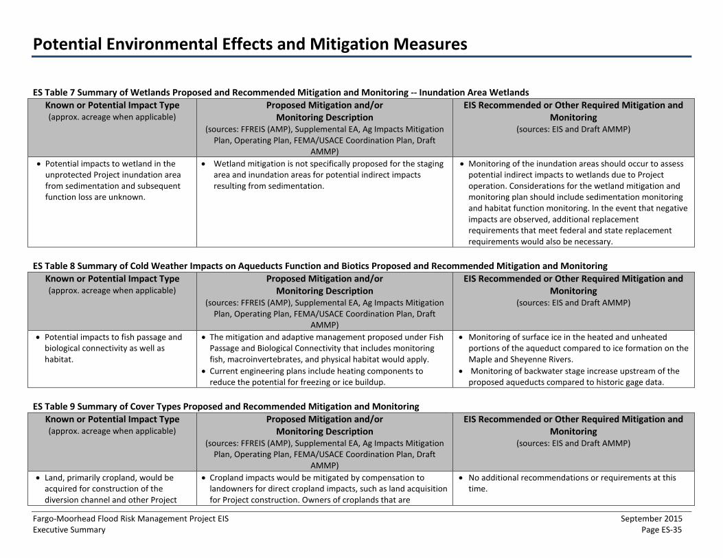
Potential Environmental Effects and Mitigation Measures
Fargo-Moorhead Flood Risk Management Project EIS September 2015 Executive Summary Page ES-35
ES Table 7 Summary of Wetlands Proposed and Recommended Mitigation and Monitoring -- Inundation Area Wetlands Known or Potential Impact Type (approx. acreage when applicable)
Proposed Mitigation and/or Monitoring Description
(sources: FFREIS (AMP), Supplemental EA, Ag Impacts Mitigation Plan, Operating Plan, FEMA/USACE Coordination Plan, Draft
AMMP)
EIS Recommended or Other Required Mitigation and Monitoring
(sources: EIS and Draft AMMP)
• Potential impacts to wetland in theunprotected Project inundation areafrom sedimentation and subsequentfunction loss are unknown.
• Wetland mitigation is not specifically proposed for the stagingarea and inundation areas for potential indirect impactsresulting from sedimentation.
• Monitoring of the inundation areas should occur to assesspotential indirect impacts to wetlands due to Projectoperation. Considerations for the wetland mitigation andmonitoring plan should include sedimentation monitoringand habitat function monitoring. In the event that negativeimpacts are observed, additional replacementrequirements that meet federal and state replacementrequirements would also be necessary.
ES Table 8 Summary of Cold Weather Impacts on Aqueducts Function and Biotics Proposed and Recommended Mitigation and Monitoring Known or Potential Impact Type (approx. acreage when applicable)
Proposed Mitigation and/or Monitoring Description
(sources: FFREIS (AMP), Supplemental EA, Ag Impacts Mitigation Plan, Operating Plan, FEMA/USACE Coordination Plan, Draft
AMMP)
EIS Recommended or Other Required Mitigation and Monitoring
(sources: EIS and Draft AMMP)
• Potential impacts to fish passage andbiological connectivity as well ashabitat.
• The mitigation and adaptive management proposed under FishPassage and Biological Connectivity that includes monitoringfish, macroinvertebrates, and physical habitat would apply.
• Current engineering plans include heating components toreduce the potential for freezing or ice buildup.
• Monitoring of surface ice in the heated and unheatedportions of the aqueduct compared to ice formation on theMaple and Sheyenne Rivers.
• Monitoring of backwater stage increase upstream of theproposed aqueducts compared to historic gage data.
ES Table 9 Summary of Cover Types Proposed and Recommended Mitigation and Monitoring Known or Potential Impact Type (approx. acreage when applicable)
Proposed Mitigation and/or Monitoring Description
(sources: FFREIS (AMP), Supplemental EA, Ag Impacts Mitigation Plan, Operating Plan, FEMA/USACE Coordination Plan, Draft
AMMP)
EIS Recommended or Other Required Mitigation and Monitoring
(sources: EIS and Draft AMMP)
• Land, primarily cropland, would beacquired for construction of thediversion channel and other Project
• Cropland impacts would be mitigated by compensation tolandowners for direct cropland impacts, such as land acquisitionfor Project construction. Owners of croplands that are
• No additional recommendations or requirements at thistime.
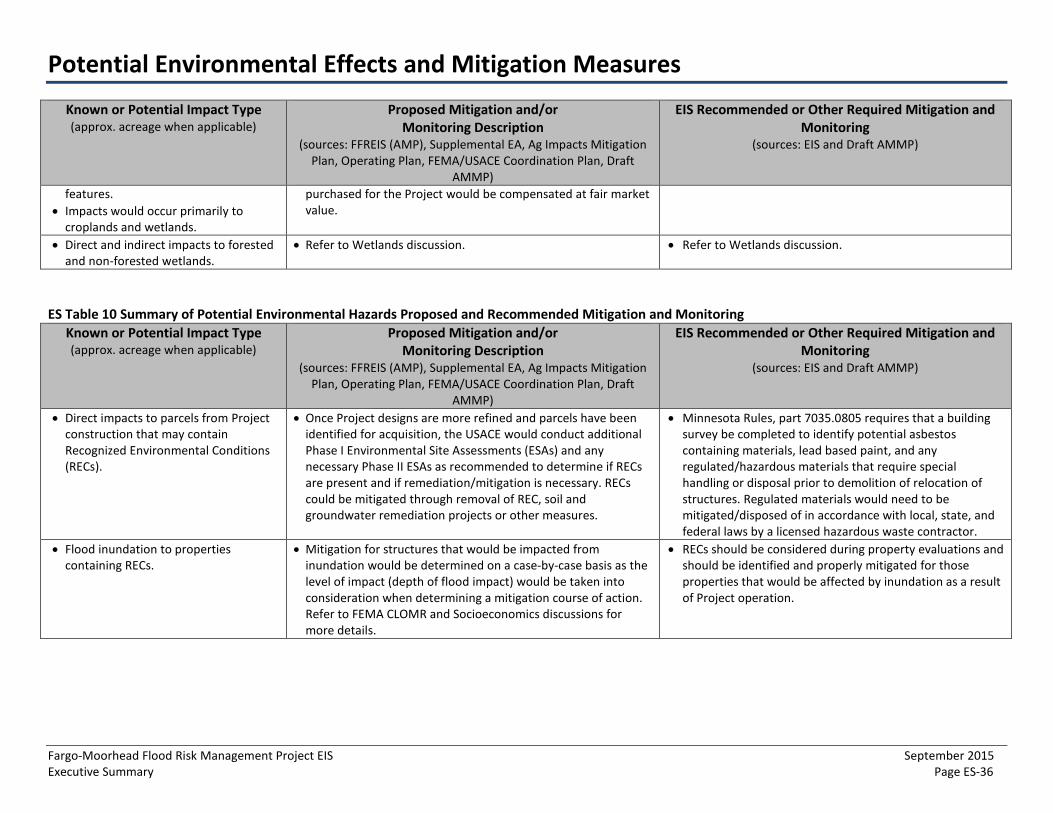
Potential Environmental Effects and Mitigation Measures
Fargo-Moorhead Flood Risk Management Project EIS September 2015 Executive Summary Page ES-36
Known or Potential Impact Type (approx. acreage when applicable)
Proposed Mitigation and/or Monitoring Description
(sources: FFREIS (AMP), Supplemental EA, Ag Impacts Mitigation Plan, Operating Plan, FEMA/USACE Coordination Plan, Draft
AMMP)
EIS Recommended or Other Required Mitigation and Monitoring
(sources: EIS and Draft AMMP)
features. • Impacts would occur primarily to
croplands and wetlands.
purchased for the Project would be compensated at fair market value.
• Direct and indirect impacts to forestedand non-forested wetlands.
• Refer to Wetlands discussion. • Refer to Wetlands discussion.
ES Table 10 Summary of Potential Environmental Hazards Proposed and Recommended Mitigation and Monitoring Known or Potential Impact Type (approx. acreage when applicable)
Proposed Mitigation and/or Monitoring Description
(sources: FFREIS (AMP), Supplemental EA, Ag Impacts Mitigation Plan, Operating Plan, FEMA/USACE Coordination Plan, Draft
AMMP)
EIS Recommended or Other Required Mitigation and Monitoring
(sources: EIS and Draft AMMP)
• Direct impacts to parcels from Projectconstruction that may containRecognized Environmental Conditions(RECs).
• Once Project designs are more refined and parcels have beenidentified for acquisition, the USACE would conduct additionalPhase I Environmental Site Assessments (ESAs) and anynecessary Phase II ESAs as recommended to determine if RECsare present and if remediation/mitigation is necessary. RECscould be mitigated through removal of REC, soil andgroundwater remediation projects or other measures.
• Minnesota Rules, part 7035.0805 requires that a buildingsurvey be completed to identify potential asbestoscontaining materials, lead based paint, and anyregulated/hazardous materials that require specialhandling or disposal prior to demolition of relocation ofstructures. Regulated materials would need to bemitigated/disposed of in accordance with local, state, andfederal laws by a licensed hazardous waste contractor.
• Flood inundation to propertiescontaining RECs.
• Mitigation for structures that would be impacted frominundation would be determined on a case-by-case basis as thelevel of impact (depth of flood impact) would be taken intoconsideration when determining a mitigation course of action.Refer to FEMA CLOMR and Socioeconomics discussions formore details.
• RECs should be considered during property evaluations andshould be identified and properly mitigated for thoseproperties that would be affected by inundation as a resultof Project operation.
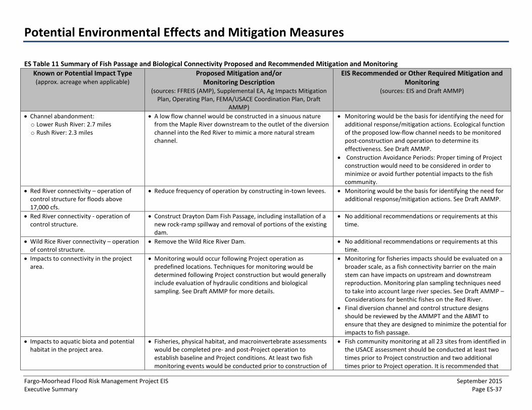
Potential Environmental Effects and Mitigation Measures
Fargo-Moorhead Flood Risk Management Project EIS September 2015 Executive Summary Page ES-37
ES Table 11 Summary of Fish Passage and Biological Connectivity Proposed and Recommended Mitigation and Monitoring Known or Potential Impact Type (approx. acreage when applicable)
Proposed Mitigation and/or Monitoring Description
(sources: FFREIS (AMP), Supplemental EA, Ag Impacts Mitigation Plan, Operating Plan, FEMA/USACE Coordination Plan, Draft
AMMP)
EIS Recommended or Other Required Mitigation and Monitoring
(sources: EIS and Draft AMMP)
• Channel abandonment:o Lower Rush River: 2.7 mileso Rush River: 2.3 miles
• A low flow channel would be constructed in a sinuous naturefrom the Maple River downstream to the outlet of the diversionchannel into the Red River to mimic a more natural streamchannel.
• Monitoring would be the basis for identifying the need foradditional response/mitigation actions. Ecological functionof the proposed low-flow channel needs to be monitoredpost-construction and operation to determine itseffectiveness. See Draft AMMP.
• Construction Avoidance Periods: Proper timing of Projectconstruction would need to be considered in order tominimize or avoid further potential impacts to the fishcommunity.
• Red River connectivity – operation ofcontrol structure for floods above17,000 cfs.
• Reduce frequency of operation by constructing in-town levees. • Monitoring would be the basis for identifying the need foradditional response/mitigation actions. See Draft AMMP.
• Red River connectivity - operation ofcontrol structure.
• Construct Drayton Dam Fish Passage, including installation of anew rock-ramp spillway and removal of portions of the existingdam.
• No additional recommendations or requirements at thistime.
• Wild Rice River connectivity – operationof control structure.
• Remove the Wild Rice River Dam. • No additional recommendations or requirements at thistime.
• Impacts to connectivity in the projectarea.
• Monitoring would occur following Project operation aspredefined locations. Techniques for monitoring would bedetermined following Project construction but would generallyinclude evaluation of hydraulic conditions and biologicalsampling. See Draft AMMP for more details.
• Monitoring for fisheries impacts should be evaluated on abroader scale, as a fish connectivity barrier on the mainstem can have impacts on upstream and downstreamreproduction. Monitoring plan sampling techniques needto take into account large river species. See Draft AMMP –Considerations for benthic fishes on the Red River.
• Final diversion channel and control structure designsshould be reviewed by the AMMPT and the ABMT toensure that they are designed to minimize the potential forimpacts to fish passage.
• Impacts to aquatic biota and potentialhabitat in the project area.
• Fisheries, physical habitat, and macroinvertebrate assessmentswould be completed pre- and post-Project operation toestablish baseline and Project conditions. At least two fishmonitoring events would be conducted prior to construction of
• Fish community monitoring at all 23 sites from identified inthe USACE assessment should be conducted at least twotimes prior to Project construction and two additionaltimes prior to Project operation. It is recommended that
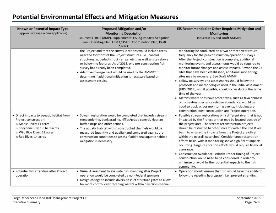
Potential Environmental Effects and Mitigation Measures
Fargo-Moorhead Flood Risk Management Project EIS September 2015 Executive Summary Page ES-38
Known or Potential Impact Type (approx. acreage when applicable)
Proposed Mitigation and/or Monitoring Description
(sources: FFREIS (AMP), Supplemental EA, Ag Impacts Mitigation Plan, Operating Plan, FEMA/USACE Coordination Plan, Draft
AMMP)
EIS Recommended or Other Required Mitigation and Monitoring
(sources: EIS and Draft AMMP)
the Project and that the survey locations would include areas near the footprint of the Project structures (i.e., control structures, aqueducts, rock-ramps, etc.), as well as sites above or below the features. As of 2015, one pre-construction fish survey has already been completed.
• Adaptive management would be used by the AMMPT todetermine if additional mitigation is necessary based onassessment results.
monitoring be conducted on a two or three-year return frequency for the pre-construction/operation surveys. After the Project construction is complete, additional monitoring events and assessments would be required to monitor future changes and assess impacts. Beyond the 23 sites that have been established, additional monitoring sites may be necessary. See Draft AMMP.
• Follow up surveys and assessments should follow theprotocols and methodologies used in the initial assessment(URS, 2013), and if possible, should occur during the sametime of the year.
• Metrics where sites have scored well, such as taxa richnessof fish-eating species or relative abundance, would begood to track across monitoring events, including pre-construction, post-construction and Project operation.
• Direct impacts to aquatic habitat fromProject construction;o Maple River: 11 acreso Sheyenne River: 8 to 9 acreso Wild Rice River: 12 acreso Red River: 14 acres
• Stream restoration would be completed that includes streamremeandering, bank grading, riffles/grade control, riparianbuffer strips and other actions.
• The aquatic habitat within constructed channels would bemeasured (quantity and quality) and compared against pre-construction conditions to assess if additional aquatic habitatmitigation is necessary.
• Possible stream restorations on a different river that is notimpacted by the Project or that may be located outside ofthe project area. The stream reconstruction projectsshould be restricted to other streams within the Red Riverbasin to ensure the impacts from the Project are offsetwithin the overall watershed. Consider large restorationefforts basin-wide if monitoring shows significant impactsoccurring. Large restoration efforts would require financialassurance.
• Construction Avoidance Periods: Proper timing of Projectconstruction would need to be considered in order tominimize or avoid further potential impacts to the fishcommunity.
• Potential fish stranding after Projectoperation.
• Visual Assessment to evaluate fish stranding after Projectoperation would be completed by non-Federal sponsors
• Design change to include diversion inlet structure gates to allowfor more control over receding waters within diversion channel.
• Operation should ensure that fish would have the ability tofollow the receding hydrograph, i.e., prevent stranding.

Potential Environmental Effects and Mitigation Measures
Fargo-Moorhead Flood Risk Management Project EIS September 2015 Executive Summary Page ES-39
ES Table 12 Summary of Wildlife and Wildlife Habitat Proposed and Recommended Mitigation and Monitoring Known or Potential Impact Type (approx. acreage when applicable)
Proposed Mitigation and/or Monitoring Description
(sources: FFREIS (AMP), Supplemental EA, Ag Impacts Mitigation Plan, Operating Plan, FEMA/USACE Coordination Plan, Draft
AMMP)
EIS Recommended or Other Required Mitigation and Monitoring
(sources: EIS and Draft AMMP)
• 62 acres of direct impacts to floodplainforest.
• See descriptions under Wetlands as wildlife habitatreplacement would be incidental to wetland replacement.
• See descriptions under Wetlands as wildlife habitatreplacement would be incidental to wetland replacement.
• Direct impacts to aquatic habitat fromProject construction;o Maple River: 11 acreso Sheyenne River: 8 to 9 acreso Wild Rice River: 12 acreso Red River: 14 acres
• See descriptions for Fish Passage and Biological Connectivity. • See descriptions for Fish Passage and BiologicalConnectivity.
ES Table 13 Summary of State-Listed Species and Special Status Species Proposed and Recommended Mitigation and Monitoring Known or Potential Impact Type (approx. acreage when applicable)
Proposed Mitigation and/or Monitoring Description
(sources: FFREIS (AMP), Supplemental EA, Ag Impacts Mitigation Plan, Operating Plan, FEMA/USACE Coordination Plan, Draft
AMMP)
EIS Recommended or Other Required Mitigation and Monitoring
(sources: EIS and Draft AMMP)
• Interruption of bald eagle nesting. • Bald eagles nests would be monitored during springconstruction season. The project area would continue to bemonitored during the upcoming years to ensure that no newnests would be impacted by Project construction.There would be raptor nest surveys completed in the spring ofthe year preceding construction within or near any affectedwooded areas.
• No additional or requirements recommendations at thistime.
• Mortality of mussels from Projectconstruction.
• Additional mussel surveys are being considered for Projectfootprint areas to verify whether impacts to mussel resourceswould be substantial. This would include determining presenceof the black sandshell, mapleleaf and Wabash pigtoe mussels.
• Recommend that additional mussel surveys be completedfor Project footprint areas.
• Interruption of cardinal and whip-poor-will nesting.
• To the extent practicable, vegetation clearing activities wouldbe done so as to avoid affecting nesting individuals.
• No additional recommendations or requirements at thistime.
• Interruption of bird nesting and rearingperiods.
• Tree clearing on forested land would occur during the wintermonths in order to not impact listed bird species during theirnesting and rearing periods.
• No additional recommendations or requirements at thistime.
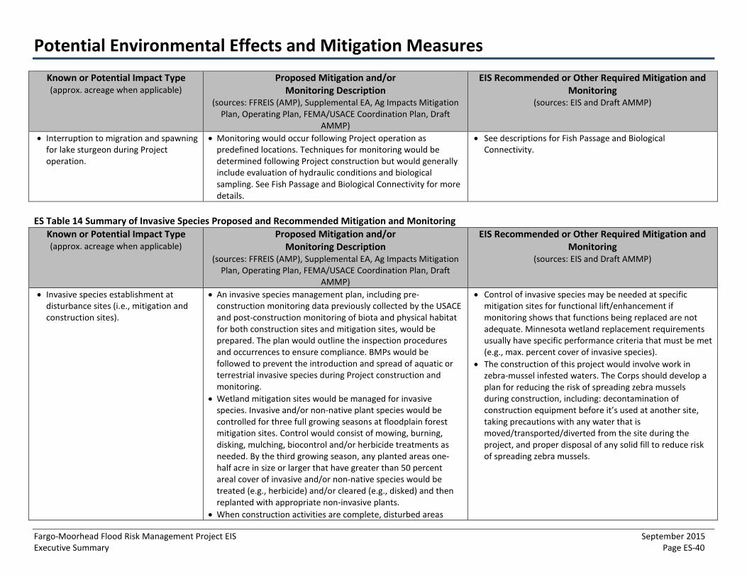
Potential Environmental Effects and Mitigation Measures
Fargo-Moorhead Flood Risk Management Project EIS September 2015 Executive Summary Page ES-40
Known or Potential Impact Type (approx. acreage when applicable)
Proposed Mitigation and/or Monitoring Description
(sources: FFREIS (AMP), Supplemental EA, Ag Impacts Mitigation Plan, Operating Plan, FEMA/USACE Coordination Plan, Draft
AMMP)
EIS Recommended or Other Required Mitigation and Monitoring
(sources: EIS and Draft AMMP)
• Interruption to migration and spawningfor lake sturgeon during Projectoperation.
• Monitoring would occur following Project operation aspredefined locations. Techniques for monitoring would bedetermined following Project construction but would generallyinclude evaluation of hydraulic conditions and biologicalsampling. See Fish Passage and Biological Connectivity for moredetails.
• See descriptions for Fish Passage and BiologicalConnectivity.
ES Table 14 Summary of Invasive Species Proposed and Recommended Mitigation and Monitoring Known or Potential Impact Type (approx. acreage when applicable)
Proposed Mitigation and/or Monitoring Description
(sources: FFREIS (AMP), Supplemental EA, Ag Impacts Mitigation Plan, Operating Plan, FEMA/USACE Coordination Plan, Draft
AMMP)
EIS Recommended or Other Required Mitigation and Monitoring
(sources: EIS and Draft AMMP)
• Invasive species establishment atdisturbance sites (i.e., mitigation andconstruction sites).
• An invasive species management plan, including pre-construction monitoring data previously collected by the USACEand post-construction monitoring of biota and physical habitatfor both construction sites and mitigation sites, would beprepared. The plan would outline the inspection proceduresand occurrences to ensure compliance. BMPs would befollowed to prevent the introduction and spread of aquatic orterrestrial invasive species during Project construction andmonitoring.
• Wetland mitigation sites would be managed for invasivespecies. Invasive and/or non-native plant species would becontrolled for three full growing seasons at floodplain forestmitigation sites. Control would consist of mowing, burning,disking, mulching, biocontrol and/or herbicide treatments asneeded. By the third growing season, any planted areas one-half acre in size or larger that have greater than 50 percentareal cover of invasive and/or non-native species would betreated (e.g., herbicide) and/or cleared (e.g., disked) and thenreplanted with appropriate non-invasive plants.
• When construction activities are complete, disturbed areas
• Control of invasive species may be needed at specificmitigation sites for functional lift/enhancement ifmonitoring shows that functions being replaced are notadequate. Minnesota wetland replacement requirementsusually have specific performance criteria that must be met(e.g., max. percent cover of invasive species).
• The construction of this project would involve work inzebra-mussel infested waters. The Corps should develop aplan for reducing the risk of spreading zebra musselsduring construction, including: decontamination ofconstruction equipment before it’s used at another site,taking precautions with any water that ismoved/transported/diverted from the site during theproject, and proper disposal of any solid fill to reduce riskof spreading zebra mussels.
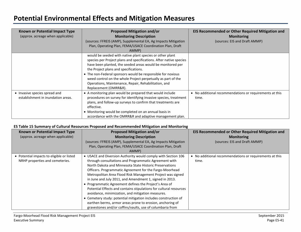
Potential Environmental Effects and Mitigation Measures
Fargo-Moorhead Flood Risk Management Project EIS September 2015 Executive Summary Page ES-41
Known or Potential Impact Type (approx. acreage when applicable)
Proposed Mitigation and/or Monitoring Description
(sources: FFREIS (AMP), Supplemental EA, Ag Impacts Mitigation Plan, Operating Plan, FEMA/USACE Coordination Plan, Draft
AMMP)
EIS Recommended or Other Required Mitigation and Monitoring
(sources: EIS and Draft AMMP)
would be seeded with native plant species or other plant species per Project plans and specifications. After native species have been planted, the seeded areas would be monitored per the Project plans and specifications.
• The non-Federal sponsors would be responsible for noxiousweed control on the whole Project perpetually as part of theOperations, Maintenance, Repair, Rehabilitation, andReplacement (OMRR&R).
• Invasive species spread andestablishment in inundation areas.
• A monitoring plan would be prepared that would includeprocedures on survey for identifying invasive species, treatmentplans, and follow-up surveys to confirm that treatments areeffective.
• Monitoring would be completed on an annual basis inaccordance with the OMRR&R and adaptive management plan.
• No additional recommendations or requirements at thistime.
ES Table 15 Summary of Cultural Resources Proposed and Recommended Mitigation and Monitoring Known or Potential Impact Type (approx. acreage when applicable)
Proposed Mitigation and/or Monitoring Description
(sources: FFREIS (AMP), Supplemental EA, Ag Impacts Mitigation Plan, Operating Plan, FEMA/USACE Coordination Plan, Draft
AMMP)
EIS Recommended or Other Required Mitigation and Monitoring
(sources: EIS and Draft AMMP)
• Potential impacts to eligible or listedNRHP properties and cemeteries.
• USACE and Diversion Authority would comply with Section 106through consultations and Programmatic Agreement withNorth Dakota and Minnesota State Historic PreservationsOfficers. Programmatic Agreement for the Fargo-MoorheadMetropolitan Area Flood Risk Management Project was signedin June and July 2011, and Amendment 1, signed in 2013.
• Programmatic Agreement defines the Project’s Area ofPotential Effects and contains stipulations for cultural resourcesavoidance, minimization, and mitigation measures.
• Cemetery study: potential mitigation includes construction ofearthen berms, armor areas prone to erosion, anchoring ofgravestones and/or coffins/vaults, use of columbaria from
• No additional recommendations or requirements at thistime.
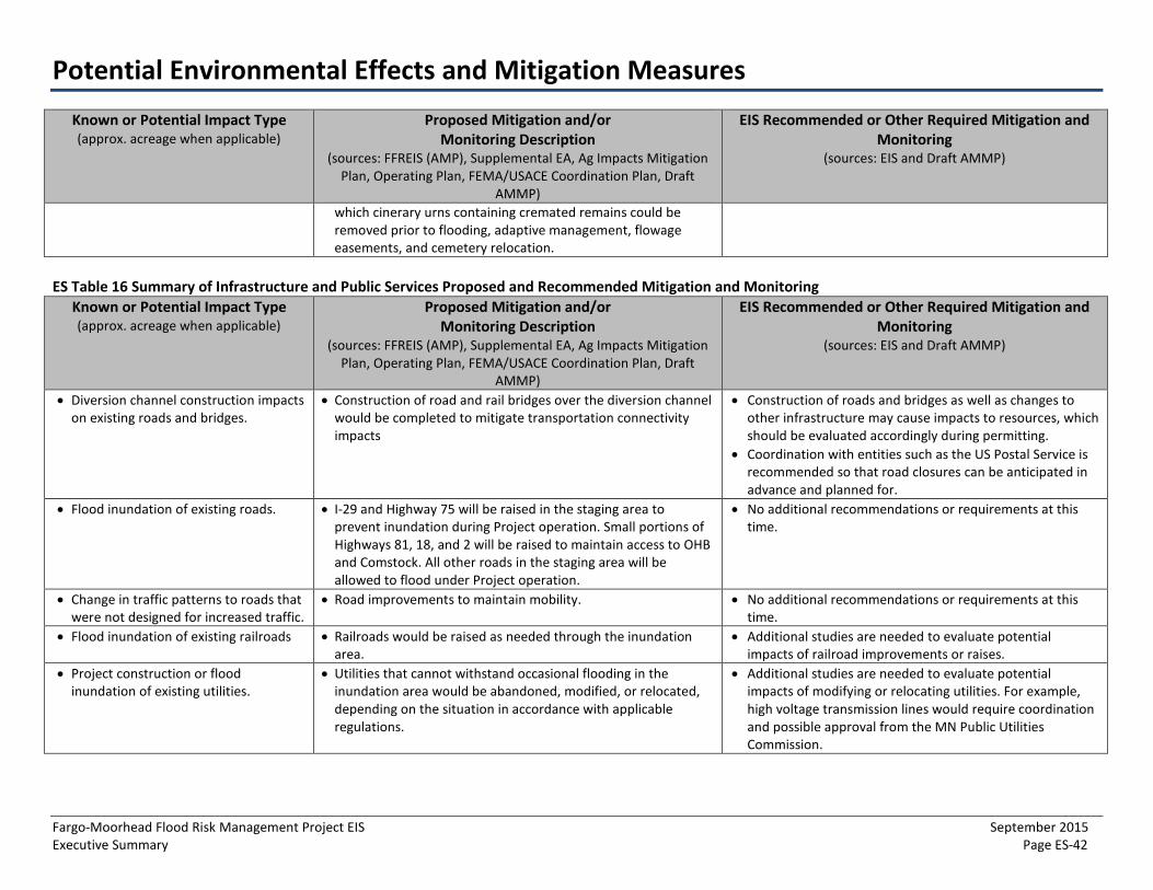
Potential Environmental Effects and Mitigation Measures
Fargo-Moorhead Flood Risk Management Project EIS September 2015 Executive Summary Page ES-42
Known or Potential Impact Type (approx. acreage when applicable)
Proposed Mitigation and/or Monitoring Description
(sources: FFREIS (AMP), Supplemental EA, Ag Impacts Mitigation Plan, Operating Plan, FEMA/USACE Coordination Plan, Draft
AMMP)
EIS Recommended or Other Required Mitigation and Monitoring
(sources: EIS and Draft AMMP)
which cinerary urns containing cremated remains could be removed prior to flooding, adaptive management, flowage easements, and cemetery relocation.
ES Table 16 Summary of Infrastructure and Public Services Proposed and Recommended Mitigation and Monitoring Known or Potential Impact Type (approx. acreage when applicable)
Proposed Mitigation and/or Monitoring Description
(sources: FFREIS (AMP), Supplemental EA, Ag Impacts Mitigation Plan, Operating Plan, FEMA/USACE Coordination Plan, Draft
AMMP)
EIS Recommended or Other Required Mitigation and Monitoring
(sources: EIS and Draft AMMP)
• Diversion channel construction impactson existing roads and bridges.
• Construction of road and rail bridges over the diversion channelwould be completed to mitigate transportation connectivityimpacts
• Construction of roads and bridges as well as changes toother infrastructure may cause impacts to resources, whichshould be evaluated accordingly during permitting.
• Coordination with entities such as the US Postal Service isrecommended so that road closures can be anticipated inadvance and planned for.
• Flood inundation of existing roads. • I-29 and Highway 75 will be raised in the staging area toprevent inundation during Project operation. Small portions ofHighways 81, 18, and 2 will be raised to maintain access to OHBand Comstock. All other roads in the staging area will beallowed to flood under Project operation.
• No additional recommendations or requirements at thistime.
• Change in traffic patterns to roads thatwere not designed for increased traffic.
• Road improvements to maintain mobility. • No additional recommendations or requirements at thistime.
• Flood inundation of existing railroads • Railroads would be raised as needed through the inundationarea.
• Additional studies are needed to evaluate potentialimpacts of railroad improvements or raises.
• Project construction or floodinundation of existing utilities.
• Utilities that cannot withstand occasional flooding in theinundation area would be abandoned, modified, or relocated,depending on the situation in accordance with applicableregulations.
• Additional studies are needed to evaluate potentialimpacts of modifying or relocating utilities. For example,high voltage transmission lines would require coordinationand possible approval from the MN Public UtilitiesCommission.
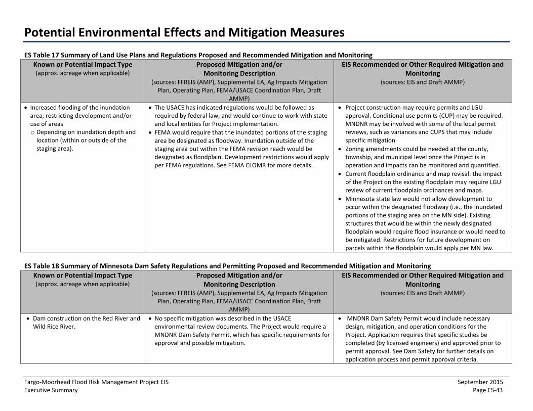
Potential Environmental Effects and Mitigation Measures
Fargo-Moorhead Flood Risk Management Project EIS September 2015 Executive Summary Page ES-43
ES Table 17 Summary of Land Use Plans and Regulations Proposed and Recommended Mitigation and Monitoring Known or Potential Impact Type (approx. acreage when applicable)
Proposed Mitigation and/or Monitoring Description
(sources: FFREIS (AMP), Supplemental EA, Ag Impacts Mitigation Plan, Operating Plan, FEMA/USACE Coordination Plan, Draft
AMMP)
EIS Recommended or Other Required Mitigation and Monitoring
(sources: EIS and Draft AMMP)
• Increased flooding of the inundationarea, restricting development and/oruse of areaso Depending on inundation depth and
location (within or outside of thestaging area).
• The USACE has indicated regulations would be followed asrequired by federal law, and would continue to work with stateand local entities for Project implementation.
• FEMA would require that the inundated portions of the stagingarea be designated as floodway. Inundation outside of thestaging area but within the FEMA revision reach would bedesignated as floodplain. Development restrictions would applyper FEMA regulations. See FEMA CLOMR for more details.
• Project construction may require permits and LGUapproval. Conditional use permits (CUP) may be required.MNDNR may be involved with some of the local permitreviews, such as variances and CUPS that may includespecific mitigation
• Zoning amendments could be needed at the county,township, and municipal level once the Project is inoperation and impacts can be monitored and quantified.
• Current floodplain ordinance and map revisal: the impactof the Project on the existing floodplain may require LGUreview of current floodplain ordinances and maps.
• Minnesota state law would not allow development tooccur within the designated floodway (i.e., the inundatedportions of the staging area on the MN side). Existingstructures that would be within the newly designatedfloodplain would require flood insurance or would need tobe mitigated. Restrictions for future development onparcels within the floodplain would apply per MN law.
ES Table 18 Summary of Minnesota Dam Safety Regulations and Permitting Proposed and Recommended Mitigation and Monitoring Known or Potential Impact Type (approx. acreage when applicable)
Proposed Mitigation and/or Monitoring Description
(sources: FFREIS (AMP), Supplemental EA, Ag Impacts Mitigation Plan, Operating Plan, FEMA/USACE Coordination Plan, Draft
AMMP)
EIS Recommended or Other Required Mitigation and Monitoring
(sources: EIS and Draft AMMP)
• Dam construction on the Red River andWild Rice River.
• No specific mitigation was described in the USACEenvironmental review documents. The Project would require aMNDNR Dam Safety Permit, which has specific requirements forapproval and possible mitigation.
• MNDNR Dam Safety Permit would include necessarydesign, mitigation, and operation conditions for theProject. Application requires that specific studies becompleted (by licensed engineers) and approved prior topermit approval. See Dam Safety for further details onapplication process and permit approval criteria.

Potential Environmental Effects and Mitigation Measures
Fargo-Moorhead Flood Risk Management Project EIS September 2015 Executive Summary Page ES-44
ES Table 19 Summary of Socioeconomics Proposed and Recommended Mitigation and Monitoring Known or Potential Impact Type (approx. acreage when applicable)
Proposed Mitigation and/or Monitoring Description
(sources: FFREIS (AMP), Supplemental EA, Ag Impacts Mitigation Plan, Operating Plan, FEMA/USACE Coordination Plan, Draft
AMMP)
EIS Recommended or Other Required Mitigation and Monitoring
(sources: EIS and Draft AMMP)
• Flood inundation to residential andagricultural farmsteads at variousdepths and agricultural land.
• See descriptions for FEMA Regulations and the CLOMR Process • See descriptions for FEMA Regulations and the CLOMRProcess
• Land, primarily cropland, would beacquired for construction of thediversion channel and other Projectfeatures.
• See description for cropland acquisition for FEMA Regulationsand the CLOMR Process, and Cover Types.
• See descriptions for FEMA Regulations and the CLOMRProcess and Cover Types.
• Comstock and OHB ring levees. • Comstock ring levee would be designed in collaboration withlocal officials and would allow for future development. Allresidents within Comstock would be protected by the ringlevee.
• OHB ring levee would require the relocation of 42 homes todifferent sites within the OHB levee. An additional 60residential lots would be added within the ring levee for otherdisplaced residents within the unprotected area.
• The Diversion Authority would compensate the City of Oxbowand the Kindred School District for loss of tax base for a periodof up to four years caused by the temporary loss of the 42homes.
• No additional recommendations or requirements at thistime.

Potential Environmental Effects and Mitigation Measures
Fargo-Moorhead Flood Risk Management Project EIS September 2015 Executive Summary Page ES-45
PAGE LEFT BLANK INTENTIONALLY
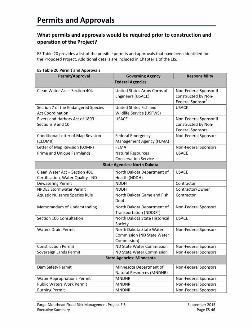
Permits and Approvals
Fargo-Moorhead Flood Risk Management Project EIS September 2015 Executive Summary Page ES-46
What permits and approvals would be required prior to construction and operation of the Project?
ES Table 20 provides a list of the possible permits and approvals that have been identified for the Proposed Project. Additional details are included in Chapter 1 of the EIS.
ES Table 20 Permit and Approvals Permit/Approval Governing Agency Responsibility
Federal Agencies
Clean Water Act – Section 404 United States Army Corps of Engineers (USACE)
Non-Federal Sponsor if constructed by Non-Federal Sponsor1
Section 7 of the Endangered Species Act Coordination
United States Fish and Wildlife Service (USFWS)
USACE
Rivers and Harbors Act of 1899 – Sections 9 and 10
USACE Non-Federal Sponsor if constructed by Non-Federal Sponsors
Conditional Letter of Map Revision (CLOMR)
Federal Emergency Management Agency (FEMA)
Non-Federal Sponsors
Letter of Map Revision (LOMR) FEMA Non-Federal Sponsors Prime and Unique Farmlands Natural Resources
Conservation Service USACE
State Agencies: North Dakota
Clean Water Act – Section 401 Certification, Water Quality - ND
North Dakota Department of Health (NDDH)
USACE
Dewatering Permit NDDH Contractor NPDES Stormwater Permit NDDH Contractor/Owner Aquatic Nuisance Species Rule North Dakota Game and Fish
Dept. Contractor
Memorandum of Understanding North Dakota Department of Transportation (NDDOT)
Non-Federal Sponsors
Section 106 Consultation North Dakota State Historical Society
USACE
Waters Drain Permit North Dakota State Water Commission (ND State Water Commission)
Non-Federal Sponsors
Construction Permit ND State Water Commission Non-Federal Sponsors Sovereign Lands Permit ND State Water Commission Non-Federal Sponsors
State Agencies: Minnesota
Dam Safety Permit Minnesota Department of Natural Resources (MNDNR)
Non-Federal Sponsors
Water Appropriations Permit MNDNR Non-Federal Sponsors Public Waters Work Permit MNDNR Non-Federal Sponsors Burning Permit MNDNR Non-Federal Sponsors

Permits and Approvals
Fargo-Moorhead Flood Risk Management Project EIS September 2015 Executive Summary Page ES-47
Permit/Approval Governing Agency Responsibility Infested Waters Permit MNDNR Non-Federal Sponsors Prohibited Invasive Species Permit MNDNR Non-Federal Sponsors Cooperative Construction Agreement Minnesota Department of
Transportation (MNDOT) Non-Federal Sponsors
Clean Water Act (CWA) – Section 401 Certification, Water Quality – MN
Minnesota Pollution Control Agency (MPCA)
USACE
NPDES Stormwater Construction Permit MPCA Contractor/Owner Section 106 Consultation Minnesota State Preservation
Historic Office USACE
Counties: Minnesota Floodplain Clay County, Minnesota Non-Federal Sponsors MN Wetland Conservation Act Clay Soil and Water
Conservation District Non-Federal Sponsors
MN Wetland Conservation Act Wilkin County, Minnesota Non-Federal Sponsors Townships: North Dakota
Building Permit Harwood Township, North Dakota
Non-Federal Sponsors
Floodplain Permit Harwood Township, North Dakota
Non-Federal Sponsors
Conditional Use Permit -Site Approval for General Ground Excavation
Mapleton Township, North Dakota
Non-Federal Sponsors
Conditional Use Permit -Site Approval for General Ground Excavation
Pleasant Township, North Dakota
Non-Federal Sponsors
Conditional Use Permit -Site Approval for General Ground Excavation
Warren Township, North Dakota
Non-Federal Sponsors
Townships: Minnesota
Interim Zoning Ordinance Holy Cross, Minnesota Non-Federal Sponsors
Municipalities: North Dakota Floodplain Permit City of Fargo, North Dakota Non-Federal Sponsors
Stormwater Permit City of Fargo, North Dakota Non-Federal Sponsors
Conditional Use Permit -Site Approval for General Ground Excavation
City of Horace, North Dakota Non-Federal Sponsors
Conditional Use Permit City of West Fargo, North Dakota
Non-Federal Sponsors
Conditional Use Permit -Site Approval for General Ground Excavation
City of Argusville, North Dakota
Non-Federal Sponsors
Municipalities: Minnesota
Floodplain Permit City of Moorhead, Minnesota Non-Federal Sponsors
Stormwater Permit City of Moorhead, Minnesota Non-Federal Sponsors
Other Jurisdictions
Application to Drain Cass County Joint Water Non-Federal Sponsors

Permits and Approvals
Fargo-Moorhead Flood Risk Management Project EIS September 2015 Executive Summary Page ES-48
Permit/Approval Governing Agency Responsibility Resource District, North Dakota (Cass County Joint WRD)
Construction/Floodplain Approval Buffalo-Red River Watershed District, Minnesota (BRRWD)
Non-Federal Sponsors
Two Rivers Watershed District (WD) Application
Two Rivers WD, Minnesota Non-Federal Sponsors
1A section 404 permit would be required for construction of the Project if construction is completed by an entity 879 other than the USACE as they are the governing agency. However, the USACE is required to adhere to Section 404 880 requirements for construction.

Organization and Content of the Environmental Impact Statement
Fargo-Moorhead Flood Risk Management Project EIS September 2015 Executive Summary Page ES-49
This EIS analyzes potential impacts from the Project for various topics as identified in the FSDD. Organization of the EIS generally follows the standard format as set forth in Minnesota Rules, part 4410.2300. The EIS is organized by the following components:
• Chapter 1 – Introduction provides a Project overview, describes the purpose and needfor the Project, and the government approvals that would be needed for constructionand operation of the Project, including the various permits and agencies that wouldreview the Project prior to construction and operation.
• Chapter 2 – Proposed Project and Project Alternatives provides detailed information onthe Project and the alternatives evaluated in the EIS, including the Base No ActionAlternative, No Action (with Emergency Measures), and the NAA. This chapter alsoprovides an alternative evaluation with information on alternatives considered, but notcarried forward for further evaluation in this EIS.
• Chapter 3 – Affected Environment and Environmental Consequences describes thepotentially affected environment in which the Base No Action Alternative, ProposedProject, No Action (with Emergency Measures), and the NAA would occur.Environmental consequences of the Project and alternatives are analyzed, and adiscussion of potential impacts is presented for each topic area, which considers short-term, long-term, beneficial, and adverse effects, and the significance of each of thosepotential effects.
• Chapter 4 – Cumulative Effects presents the results of the analysis that identified thepotential for cumulative effects within a local and regional context.
• Chapter 5 – Comparison of Alternatives provides a summary of each of the alternativesrelevant to the Project purpose and potential impacts.
• Chapter 6 –Mitigation and Monitoring Measures describes mitigation measures thatcould reasonably eliminate or minimize adverse environmental, economic, orsociological effects of the Project. Identifying these measures is required per MinnesotaRules, part 4410.2300. To meet this requirement, the EIS evaluates and discussesmitigation measures to address adverse effects identified as a result of analysesproposed in Chapter 3 of the EIS.
• Chapter 7 – Consultation and Coordination describes how the MNDNR and USACEdeveloped the FEIS in coordination with other state and federal agencies, tribal entities,and the public. This chapter also includes a distribution list of the individuals andorganizations that will receive the EIS.
• Chapter 8 – List of Preparers provides a list of preparers and document reviewers, theirqualifications, and areas of responsibility.
• Chapter 9 – References provides a list of references that were used during theevaluation and analysis for the EIS and are cited in the EIS text.
• Figures and Appendices are also included in the EIS, and the reader is directed to thesesources of information as needed throughout the EIS.


