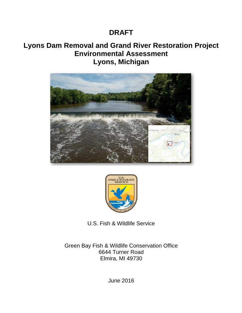
DRAFT Lyons Dam Removal and Grand River Restoration Project Environmental Assessment Lyons, Michigan U.S. Fish & Wildlife Service Green Bay Fish & Wildlife Conservation Office 6644 Turner Road Elmira, MI 49730 June 2016
Transcript
DRAFT
Lyons Dam Removal and Grand River Restoration Project Environmental Assessment
Lyons, Michigan
U.S. Fish & Wildlife Service
Green Bay Fish & Wildlife Conservation Office 6644 Turner Road Elmira, MI 49730
June 2016
ACKNOWLEDGEMENT
This Environmental Assessment was prepared under a grant received by the Ionia Conservation District, as Administered through the Great Lakes Restoration Initiative and the United States Fish & Wildlife Service’s National Fish Passage Program in cooperation with the Village of Lyons, Michigan Department of Environmental Quality and the Michigan Department of Natural Resources, in support of the removal of the Lyons Dam and restoration of the Grand River.
1.4.1 Dam Age, Condition, and Public Safety ................................................. 6 1.4.2 Ecosystem Degradation ........................................................................ 8
1.5 Applicable Regulatory Requirements and Coordination ....................................... 9 1.5.1 Public and Agency Involvement ............................................................ 9 1.5.2 Permitting ............................................................................................ 10
2.0 Description of the Proposed Action and Alternatives .............................................. 13
2.1 Alternative A: No Action ..................................................................................... 13 2.2 Alternative B: Lyons Dam Removal with Grand River Restoration .................... 13
2.2.1 Construction Activities ......................................................................... 15 2.3 Other Alternatives Considered ........................................................................... 21
3.0 Affected Environment and Environmental Consequences ...................................... 24
Appendix A MDEQ Emergency Order- Lyons Dam May 26, 2016
Appendix B Sequence of Work and Narrative Lyons Dam Removal and Toewood Bench Construction at Lyons, Michigan for the Village of Lyons and the Ionia County Conservation District. June 14, 2016.
Appendix C Lyons Dam Removal NEPA EA Public Scoping Meeting Summary and Comments Received
Appendix D Letter Report: Sediment Sampling and Analytical Results, Lyons Dam Removal and Grand River Restoration Project
Appendix E Agency Consultation
List of Tables
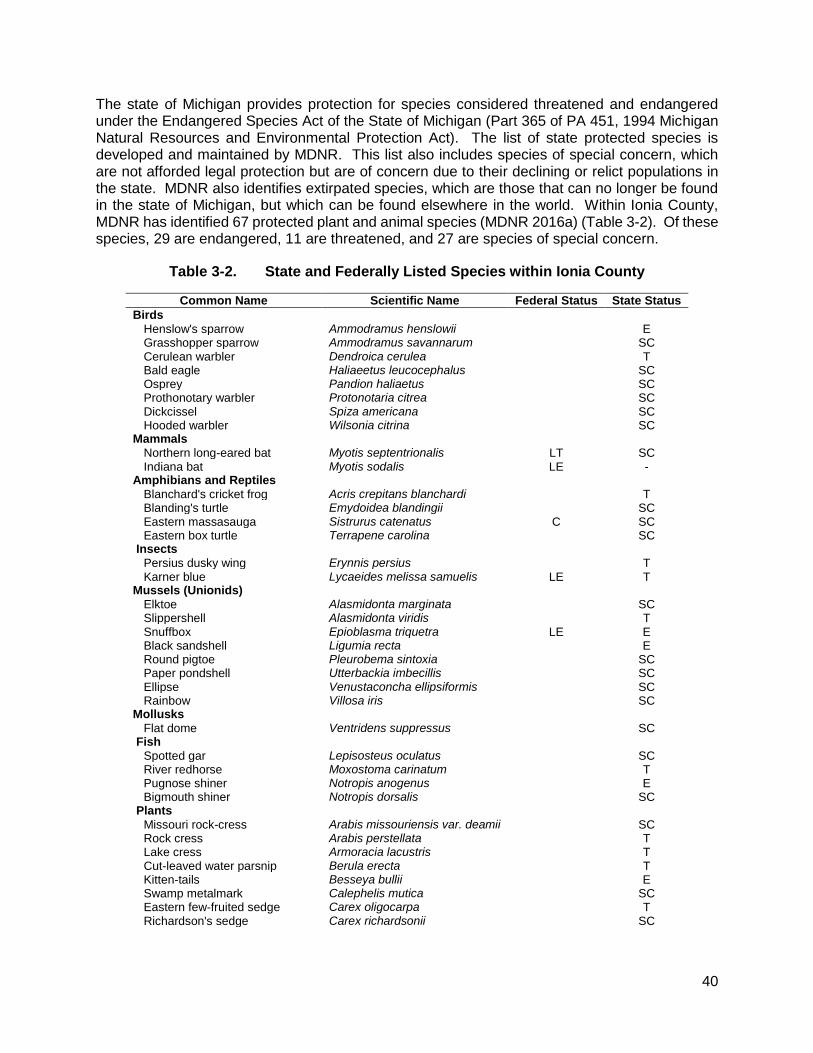
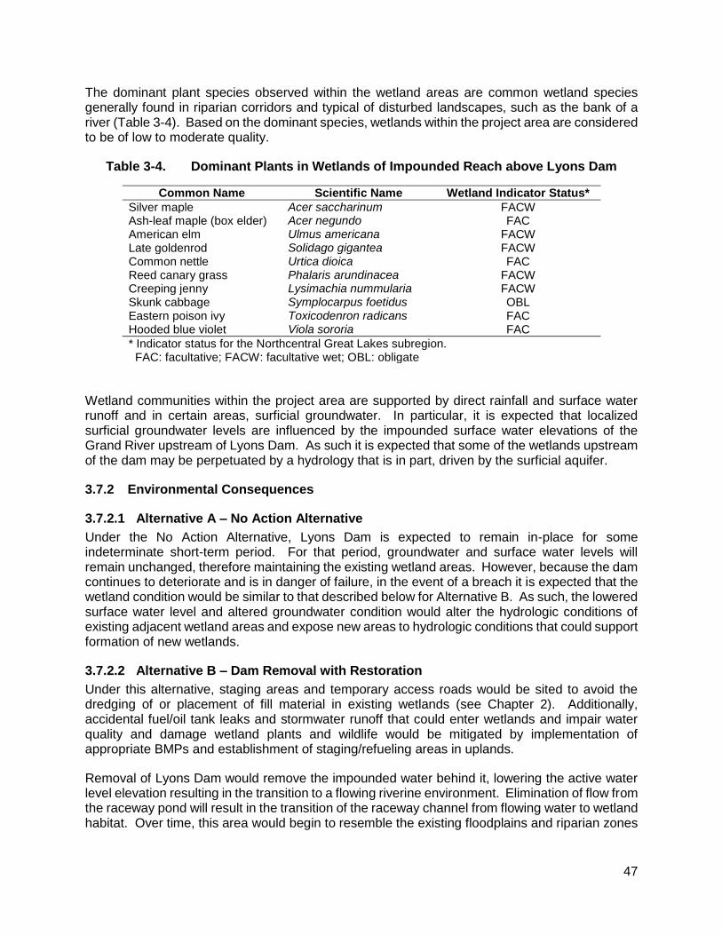
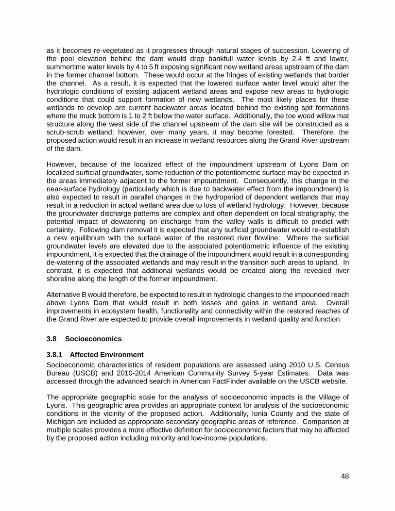
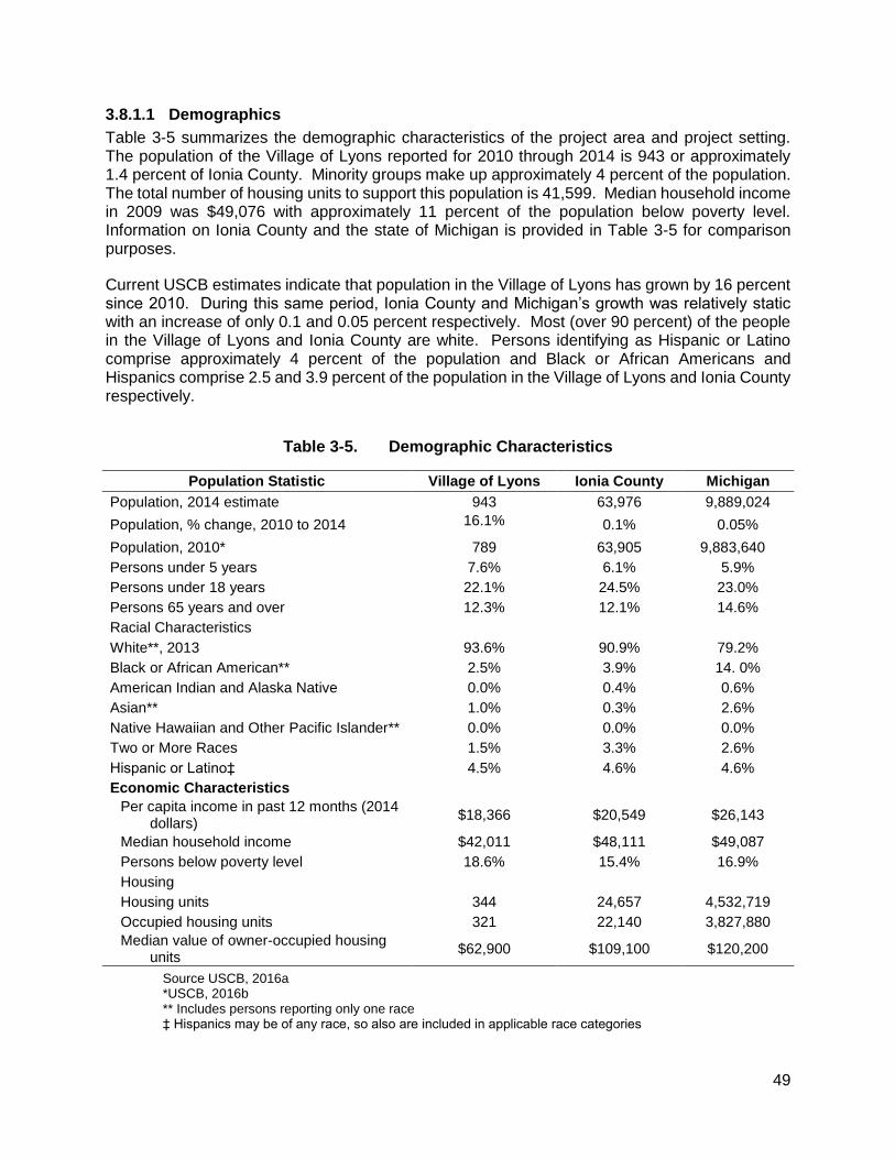
Table 1-1. Authorizations Required for Lyons Dam Removal and Ecosystem Restoration Activities 11 Table 2-1. Primary Characteristics of the Lyons Dam Removal/Grand River Restoration Project .... 14 Table 2-2. Summary and Comparison of Alternatives by Resource Area ......................................... 22 Table 3-1. Land Use/Land Cover within a 3-Mile Radius.................................................................. 36 Table 3-2. State and Federally Listed Species within Ionia County .................................................. 40 Table 3-3. Wetland Communities Identified within the Impounded Reach above Lyons Dam .......... 45 Table 3-4. Dominant Plants in Wetlands of Impounded Reach above Lyons Dam ........................... 47 Table 3-5. Demographic Characteristics .......................................................................................... 49 Table 3-6. Employment Characteristics ........................................................................................... 50
List of Figures
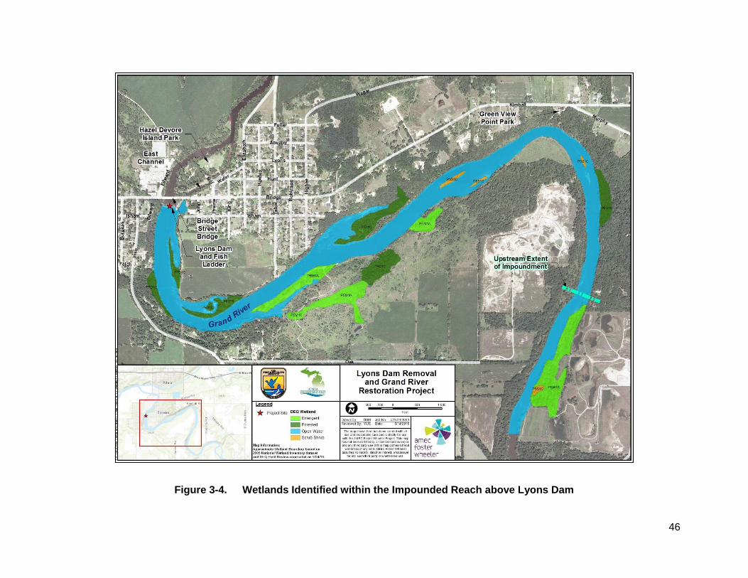
Figure 1-1. Lyons Dam Project Location ............................................................................................. 2 Figure 1-2. Simplified Cross Section of Lyons Dam ............................................................................ 3 Figure 1-3. Existing Conditions at Lyons Dam ..................................................................................... 4 Figure 1-4. Recent Views of Lyons Dam, May-June 2016 ................................................................... 7 Figure 2-1. Proposed Access Roads and Material Storage Area....................................................... 16 Figure 2-2. Proposed Fill in Raceway Pond ...................................................................................... 17 Figure 2-3. Cross Section of Lyons Dam Illustrating Pre- and Post-Project Conditions ..................... 18 Figure 2-4. Proposed Bank Stabilization Measures ........................................................................... 19 Figure 3-1. Land Use Land Cover within the Vicinity of Lyons Dam .................................................. 26 Figure 3-2. Water Resources in the Vicinity of Lyons Dam ................................................................ 29 Figure 3-3. Supplemental Sediment Sampling Locations .................................................................. 33 Figure 3-4. Wetlands Identified within the Impounded Reach above Lyons Dam .............................. 46
iv
List of Abbreviations and Acronyms
ac Acre
APE Area of Potential Effect
BA Biological Assessment
BMP Best Management Practices
bgs Below Ground Surface
C Celsius
BO Biological Opinion
CEQ Council on Environmental Quality
CFR Code of Federal Regulations
cfs Cubic Feet Per Second
COPCs Constituents of Potential Concern
CWA Clean Water Act of 1972
EA Environmental Assessment
Eco-SLL Ecological Screening Levels for Sediments
EJ Environmental Justice
EO Executive Order
ERP Ellen River Partners
ESA Endangered Species Act of 1973
ft Feet
MDEQ Michigan Department of Environmental Quality
MDNR Michigan Department of Natural Resources
MDOT Michigan Department of Transportation
mg/kg Micrograms per Kilogram
mi Mile
mi2 Square Mile
msl Mean Sea Level
NEPA National Environmental Policy Act
SHPO State Historic Preservation Office
NAAQS National Ambient Air Quality Standards
NAVD North American Vertical Datum of 1988
NEPA National Environmental Policy Act
NRHP National Register of Historic Places
PCB Polychlorinated Biphenyl
PEC Probable Effect Concentration
TEC Threshold Effect Concentration
USCB U.S. Census Bureau
USEPA U.S. Environmental Protection Agency
USFWS U.S. Fish & Wildlife Service
USGS U.S. Geological Survey
1
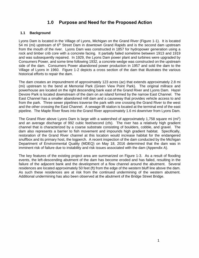
1.0 Purpose and Need for the Proposed Action
1.1 Background
Lyons Dam is located in the Village of Lyons, Michigan on the Grand River (Figure 1-1). It is located 54 mi (mi) upstream of 6th Street Dam in downtown Grand Rapids and is the second dam upstream from the mouth of the river. Lyons Dam was constructed in 1857 for hydropower generation using a rock and timber crib core with a concrete facing. It partially failed sometime between 1913 and 1919 and was subsequently repaired. In 1929, the Lyons Dam power plant and turbines were upgraded by Consumers Power, and some time following 1932, a concrete wedge was constructed on the upstream side of the dam. Consumers Power abandoned power production in 1957 and sold the dam to the Village of Lyons in 1960. Figure 1-2 depicts a cross section of the dam that illustrates the various historical efforts to repair the dam.
The dam creates an impoundment of approximately 123 acres (ac) that extends approximately 2.8 mi (mi) upstream to the bend at Memorial Park (Green View Point Park). The original millrace and powerhouse are located on the right descending bank east of the Grand River and Lyons Dam. Hazel Devore Park is located downstream of the dam on an island formed by the narrow East Channel. The East Channel has a smaller abandoned mill dam and a causeway that provides vehicle access to and from the park. Three sewer pipelines traverse the park with one crossing the Grand River to the west and the other crossing the East Channel. A sewage lift station is located at the terminal end of the east pipeline. The Maple River flows into the Grand River approximately 1.6 mi downriver from Lyons Dam.
The Grand River above Lyons Dam is large with a watershed of approximately 1,758 square mi (mi2) and an average discharge of 992 cubic feet/second (cfs). The river has a relatively high gradient channel that is characterized by a coarse substrate consisting of boulders, cobble, and gravel. The dam also represents a barrier to fish movement and impounds high gradient habitat. Specifically, restoration of the Grand River channel at this location would increase habitat for the endangered snuffbox and its primary host, the logperch. A recent inspection of the dam conducted by the Michigan Department of Environmental Quality (MDEQ) on May 18, 2016 determined that the dam was in imminent risk of failure due to instability and risk issues associated with the dam (Appendix A).
The key features of the existing project area are summarized on Figure 1-3. As a result of flooding events, the left-descending abutment of the dam has become eroded and has failed, resulting in the failure of the adjacent bank and the development of a flow channel around the abutment. Several residences are located approximately 50 feet (ft) from the edge of the western bluff line above the dam. As such these residences are at risk from the continued undermining of the western abutment. Additional undermining has also been observed at the abutment of the Bridge Street Bridge.
2
Figure 1-1. Lyons Dam Project Location
3
Figure 1-2. Simplified Cross Section of Lyons Dam
4
Figure 1-3. Existing Conditions at Lyons Dam
5
In addition to historical repairs to the dam described above, several recent emergency actions have been undertaken in the past to address safety issues either directly or indirectly related to the dam including:
1. Placement of rip-rap at the western abutment to provide temporary improvements to instability.
2. Placement of large cobble and small boulders along the bridge piers (it is dug out between piers now) and to shield sewage lines under the river downstream of the bridge. Subsequently floodwaters have moved the cobble and gravel downstream where it was deposited on the riffle north of Hazel Devore Island. The riffle expanded and grew in height resulting in the erosion of an area 30 to 50 ft wide by 500 ft long of Hazel Devore Island as a result of bankfull flow (Appendix B).
3. In 2012, a stone bankfull bench and a straight vane were installed downstream of Hazel Devore Island under an emergency permit to protect the sewage lift station that had been threatened by bank erosion.
4. Emergency conditions were declared at the raceway gates where erosion under and through the gates sent high velocity water through the raceway pond, under Bridge Street to the north and began eroding the sand access road along the north side of the Raceway Channel.
5. High velocities through the undersized culverts in the causeway are threatening home decks and foundations downstream of the causeway. Blocking stone was placed just upstream of the raceway gates by Michigan Department of Natural Resources (MDNR) Fisheries in 2011 to minimize the eroding flow pattern set up in the raceway, but high velocities still exit the causeway culverts.
A recent inspection of the dam conducted by the MDEQ on May 18, 2016 determined that the dam was in imminent risk of failure (see Appendix A). On May 26, 2016, the MDEQ issued an enforcement order to the Village of Lyons mandating that a contingency plan be developed in support of near-term actions to address the instability and risk issues associated with the dam.
In response to the enforcement order issued by MDEQ, the Village of Lyons in cooperation with the Ionia Conservation District developed an interim action plan using non-federal funds to perform stabilization activities aimed at temporarily stabilizing the west abutment and the by-pass channel. Subject to appropriate safe flow conditions, the proposed interim action is scheduled to be initiated on or about July 5, 2016.
1.2 National Environmental Policy Act
Pursuant to the requirements of the National Environmental Policy Act (NEPA), this Environmental Assessment (EA) analyzes potential impacts of the proposed project to elements of the natural and human environment as per the Council on Environmental Quality (CEQ) regulations implementing NEPA (40 Code of Federal Regulations [CFR] Parts 1500-1508). Because federal funds administered by the Department of Interior are anticipated for use in removal of Lyons Dam, the United States Fish & Wildlife Service (USFWS) is the lead federal agency for this proposed action. The purpose of the EA is to ensure the USFWS compliance with the regulations set forth by the CEQ provisions of NEPA, and the USFWS implementing regulations.
6
1.3 Proposed Action
The proposed project is to remove approximately 8.2 ft of the 13.1-ft high by 275-ft wide Lyons Dam, close the adjacent fish ladder, and restore high gradient habitat of the Grand River near Lyons, Michigan. The removal of the dam is also needed due to the failure of the downstream face concrete on the dam and severe erosion at the west end of the dam threatening property above on the high bank and the west abutment of the Bridge Street Bridge. This Federal action is intended to expand the action associated with the emergency response action proposed to be initiated on July 5, 2016 to provide for dam deconstruction that will meet the identified needs as described below. Project partners include the Village of Lyons, Ionia Conservation District, MDNR, Central Michigan University, Ellen River Partners (ERP), Michigan Department of Transportation (MDOT), Federal Highway Administration, Fleis and VandenBrink Engineering Inc., and USFWS.
1.4 Project Need
Several key issues contribute to the need for the removal of Lyons Dam. These needs include those associated with the age and existing condition of the dam and the imminent risk of dam failure and need to address public safety, the effects of the dam on the local aquatic ecosystem, support for the restoration of federal and state endangered species, and the opportunities for ecosystem restoration on the Grand River.
1.4.1 Dam Age, Condition, and Public Safety
A prior dam safety report identified structural deficiencies and concluded the dam represented a low hazard (MDEQ 2008). The report specifically referenced concern for the deteriorating spillway and recommended removal or repair by December 2011. The Village of Lyons is the dam owner and decided in 2012 to remove the dam instead of repairing it. The fish ladder located at the east end of Lyons Dam was built in the 1980s and is owned by the MDNR. In 2001, MDNR reinforced the structure due to erosion along the east side of the dam. MDNR will no longer operate the fish ladder when Lyons Dam is removed.
As described in Section 1.1, MDEQ recently conducted an inspection of the dam on May 18, 2016 to evaluate the existing condition and assess potential risks of continued degradation of the structural integrity of the dam. Key findings of that inspection include the following:
1. Increased failure of the left descending abutment resulting in by-pass flow;
2. Expansion of the associated erosion and failure of the slope on the west side of the dam;
3. Narrow (<50 ft) margin between top of west bank and residential structure;
4. Indications of dam settlement or subsurface flow;
5. Deterioration of the spillway face; and
6. Failing stop logs at the millrace inlet structure (Figure 1-4).
7
(Arrows indicating dam face fracture points and subsurface flow)
(Flow and erosion/slope failure at upstream end of west abutment wall) (Photo credit: Luke Trumble, MDEQ)
Figure 1-4. Recent Views of Lyons Dam, May-June 2016
As a consequence of that inspection, MDEQ determined that the dam was in imminent risk of failure and issued an enforcement order to the Village of Lyons mandating that a contingency plan be developed in support of near-term actions to address the instability and risk issues associated with the dam (see Appendix A).
If left unaddressed, it is expected that the river would continue to by-pass the left-descending abutment and would continue to form a side channel by accelerating erosion and bank failure of the associated bluff, thereby putting the residential property on the bluff above the river at risk. Additionally, because of continuing degradation of the face of the dam, there is the potential for catastrophic failure of the dam
8
under higher flow conditions. Such a catastrophic event would have the effect of sending a massive pulse of river flow downstream that would potentially result in extensive river bed scour, bank erosion and failure, and flooding of adjacent lands and properties.
As such, the dam represents a clear and unmitigated hazard and concern to public safety.
1.4.2 Ecosystem Degradation
Lyons Dam has the effect of creating a pooled (lentic) aquatic environment within the otherwise riverine reach of the Grand River. While this pooled environment has selected value to some users, it has a pronounced effect on introducing an otherwise unnatural condition that contributes to ecosystem degradation. These commonly encountered effects of small dams have been documented by others (American Rivers and Trout Unlimited 2002; Hayes, et al. 2006; Conyngham, et al. 2006; and USFWS 2012) and include the following:
Habitat Fragmentation. The presence of Lyons Dam has the effect of segmenting the Grand River into discontinuous reaches that include the Grand River from the 6th Street Dam in Grand Rapids to Lyons Dam, and from Lyons Dam to Wagar Dam (4.2 mi), and from Wagar Dam to Webber Dam (2.0 mi) (see Figure 1-1). Such segmentation has the effect of isolating resident populations of fish and other aquatic biota that increases their vulnerability to adverse environmental conditions (e.g., pollution, habitat degradation, wetland filling) while reducing the opportunity for genetic exchange between segmented populations. The removal of the dam would effectively reconnect 15.5 mi of habitat upstream with 54 mi of habitat downstream and would provide passage for fish and other aquatic species. Fragmentation also limits access to areas with suitable spawning habitat, optimal food availability, and protection from predators (Conyngham et al. 2006).
Induced Species Disruptions. In its current condition, the dam allows salmonids to ascend upstream through a fish ladder and ascend the river to the city of Lansing. However, native warmwater fish species do not use the ladder, effectively blocking them from upstream movement. Representative native fish species include walleye (Sander vitreus), smallmouth bass (Micropterus dolomieu), northern pike (Esox lucius), white sucker (Catostomus commersonii), logperch (Percina caprodes), channel catfish (Ictalurus punctatus) and the state threatened river redhorse (Moxostoma carinatum) (Hanshue and Harrington 2013).
Of additional concern is the limitation of movement of the logperch, which is a known host species to the larval form of the endangered snuffbox mussel (Epioblasma triquetra). As a result the distribution of the logperch that host glochidia (larval) forms of the snuffbox are limited to areas downstream of Lyons Dam. Consequently, snuffbox distribution is also limited to downstream areas. The dam acts as an effective barrier for other species in a similar manner that cannot overcome the flow or vertical physical barrier that prevents their upstream movement. Dam removal is, therefore, needed to allow native fish passage upstream and to restore high gradient habitat and expand the range of movement of resident native species including river redhorse, snuffbox mussel, and possibly lake sturgeon (Acipenser fulvescens). The area above Lyons Dam has the highest potential for lake sturgeon spawning habitat in the watershed (Seelbach et al.1997), and there are discussions regarding opportunities to pass this species above the barriers in Grand Rapids as part of Grand River Restoration Project, which has been designated as a pilot location for the Urban Waters Federal Partnership (U.S. Environmental Protection Agency [USEPA] 2016c).
The removal of Lyons Dam would reduce long-term management costs associated with fish ladder maintenance and operation and may lead to more natural reproduction and increased abundance of walleye, steelhead (Oncorhynchus mykiss), coho salmon (Oncorhynchus kisutch), and chinook salmon (Oncorhynchus tshawytscha). MDNR currently invests over $350,000 annually to stock walleye and salmonids to maintain the fishery from Lake Michigan to Lansing.
9
Habitat Degradation. As a result of the above-referenced habitat fragmentation and its hydrologic alterations, habitats within the Grand River and its associated bottomlands have been modified and degraded, resulting in adverse impacts on aquatic species mix, diversity, and populations. This habitat degradation is expressed in several characteristic ways:
o Interruption of Downstream Transport Processes. The presence of the dam has the effect of interrupting and limiting the downstream transport of woody debris and plant propagules critical to sustaining healthy populations of desirable fish and invertebrate species. Woody debris provides food, refuge, cover and channel diversity to fish and invertebrate species, and provides protection from excessive riverbank erosion (Conyngham et al. 2006).
o Alteration of Surface Water and Groundwater Flow Patterns. Impoundment of the Grand River at Lyons Dam has had the effect of altering surface water and groundwater flow patterns. Maintenance of the impoundment at Lyons Dam not only creates a still water (lentic) habitat within the impoundment itself that contributes to bank failure and erosion (see Figure 1-4), but it also has the associated effect of creating backwater that extends approximately 2.8 mi upstream within the river. As a result, surface water flows are modified from that of a natural flowing river which has the effect of increased sedimentation and altering instream habitat. Backwater effects also result in the “perching” of groundwater in the upstream vicinity of the impoundment thereby altering groundwater flow and discharge characteristics.
o Interruption and Alteration of Sedimentation Processes. Downstream transport of sediments naturally carried by the river is also interrupted by the presence of Lyons Dam. Consequently, the natural equilibrium associated with riverine sediment transport processes is disrupted. This alteration in sedimentation pattern caused by the presence of dams effectively “starves” reaches of the Grand River downstream from Webber Dam and extending to below Lyons Dam. This effect was reported by ERP (see Appendix B) who estimated that sediment within the river upstream of Lyons Dam was equivalent to a depth of sediment approximately 0.7 ft deep within the 2.3 mi pool upstream of Lyons Dam (ERP 2016). Reduced availability of fine sediments within this reach results in a corresponding reduction in instream habitat heterogeneity (substrate type) that would be expected to have a corresponding effect on associated aquatic species, thereby compromising spawning areas for invertebrates and fish species (Conyngham et al. 2006).
1.5 Applicable Regulatory Requirements and Coordination
The following sections describe local, state, and federal regulatory requirements that must be addressed as part of the NEPA process, as well as coordination with the public, Native American tribes and government agencies.
1.5.1 Public and Agency Involvement
Public involvement and coordination with local, Tribal, state, and federal resource management agencies is a vital component of the NEPA process. The USFWS, the Village of Lyons, and the Ionia Conservation District have engaged the public in a variety of ways during the development of this EA. A public meeting was hosted by USFWS at the Lyons fire house on February 3, 2016 to solicit general input from the public about the proposed dam removal. Approximately 85 people attended that meeting. The meeting included general exhibits and a presentation made by USFWS. Content of the meeting included presentation of the project purpose and need, environmental setting and key project features, project alternatives under consideration, and elements of the NEPA process. Comments were received at the meeting and subsequently by mail and e-mail throughout preparation of the EA. A summary of the scoping meeting and public comments received is included in Appendix C.
10
Key topics raised by respondents included those focused on the potential benefits of the proposed action regarding its restoration of environmental habitats and processes, recreational issues, loss of “pond” habitat and associated recreational opportunities, relocation of the snuffbox mussel, sediment quality in lands exposed by dewatering, and the preliminary alternatives under consideration (No Action, dam rehabilitation, and dam removal).
Coordination was also conducted with several agencies and interested parties to solicit input to the NEPA planning process with the MDNR, MDEQ, USEPA, and Michigan State Housing Development Authority State Historic Preservation Office (SHPO). Key issues raised by agencies included potential concerns regarding potential impacts to wetlands, surface water quality impacts, sediment transport and deposition, potential sediment contamination and transport, the dam removal process and stream restoration techniques, and invasive species management.
This Draft EA has been made available for public review and is posted to the USFWS website. Distribution of the Draft EA includes making hard copies available at a number of public facilities including the following:
Village of Lyons, 212 Water Street, Lyons, MI 48851;
Lyons Township District Library, 240 East Bridge Street; Lyons, MI 48851;
Ionia Conservation District, 431 Swartz Ct. #300, Ionia, MI 48846, and
USFWS, Elmira Field Office, 6644 Turner Road, Elmira, MI 49730.
In consideration of the urgency of the stated need regarding public safety and the established enforcement order issued by the MDEQ, the Draft EA is available for public review and comment, and written comments must be submitted within 10 days of this announcement or by June 27, 2016 to:
Sandra Sroonian Amec Foster Wheeler Environment & Infrastructure, Inc.
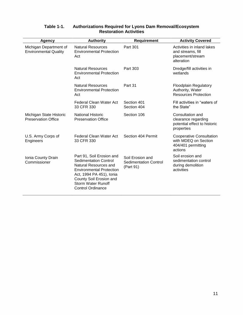
A number of permits and other authorizations must be obtained to implement the action under consideration. The primary permitting action that governs dam removal is specified by Part 315 of the Michigan Natural Resources Environmental Protection Act and is administered by the MDEQ.
The permits/approvals that may be required for the removal of the dam and ecosystem restoration are listed in Table 1-1.
11
Table 1-1. Authorizations Required for Lyons Dam Removal/Ecosystem Restoration Activities
Agency Authority Requirement Activity Covered
Michigan Department of Environmental Quality
Natural Resources Environmental Protection Act
Part 301 Activities in inland lakes and streams, fill placement/stream alteration
Natural Resources Environmental Protection Act
Part 303 Dredge/fill activities in wetlands
Natural Resources Environmental Protection Act
Part 31 Floodplain Regulatory Authority, Water Resources Protection
Federal Clean Water Act 33 CFR 330
Section 401 Section 404
Fill activities in “waters of the State”
Michigan State Historic Preservation Office
National Historic Preservation Office
Section 106 Consultation and clearance regarding potential effect to historic properties
U.S. Army Corps of Engineers
Federal Clean Water Act 33 CFR 330
Section 404 Permit Cooperative Consultation with MDEQ on Section 404/401 permitting actions
Ionia County Drain Commissioner
Part 91, Soil Erosion and Sedimentation Control Natural Resources and Environmental Protection Act, 1994 PA 451), Ionia County Soil Erosion and Storm Water Runoff Control Ordinance
Soil Erosion and Sedimentation Control (Part 91)
Soil erosion and sedimentation control during demolition activities
This page intentionally left blank.
13
2.0 Description of the Proposed Action and Alternatives
A basic principle of NEPA is that an agency should consider reasonable alternatives to a proposed action. Considering alternatives helps to avoid unnecessary impacts and allows analysis of reasonable ways to achieve the stated purpose. To warrant detailed evaluation, an alternative must be reasonable. To be considered reasonable, an alternative must be ready for decision making (any necessary preceding events having taken place), affordable, capable of implementation and satisfactory with respect to meeting the purpose of and need for the action.
During the public scoping process, USFWS clarified that preliminary alternatives subject to consideration as part of the NEPA process included the No Action alternative and the dam removal alternative. No other alternatives were considered based on the poor condition of dam, and unfeasibility of refurbishing the dam in a cost-effective manner. However, following the public scoping period, one commenter who had attended the public scoping meeting indicated that he knew of a party who had interest in rehabilitation of the dam, restoration of hydropower, and who would assume all legal and financial responsibility for the project. In response, the Village of Lyons extended an invitation to submit a proposal to undertake the proposed dam rehabilitation in a timely fashion. However, the interested party failed to submit a proposal that demonstrated his ability to undertake the project. Consequently, despite the expressed interest of several commenters who encouraged the consideration of a dam rehabilitation alternative, no such alternative is considered to be viable. This preliminary alternative was therefore, eliminated from further consideration.
The following alternatives are evaluated in this EA.
2.1 Alternative A: No Action
Under CEQ regulations (40 CFR Parts 1500 to 1508), consideration of a No Action Alternative is required in this EA. The No Action Alternative sets a baseline of existing impact continued into the future against which to compare impacts of action alternatives. This is important context information in determining the relative magnitude and intensity of impacts.
Under the No Action Alternative, the USFWS and Ionia Conservation District would take no action to remove or rehabilitate the dam, improve fish passage and habitat, or reduce the Village of Lyons safety liabilities associated with ownership of Lyons Dam. Existing facilities including the dam and fish ladder would remain in-place and would continue to impede fish passage and sustain the fragmented habitats within the Grand River system. Additionally, the structural deterioration of the dam will continue to persist. Because the Village of Lyons lacks the financial resources to maintain the facilities, the safety issues (e.g., dam failure) associated with the existing facility would go unaddressed. Consequently, this alternative would result in the eventual failure of Lyons Dam.
2.2 Alternative B: Lyons Dam Removal with Grand River Restoration
Under Alternative B, the proposed project would include the removal of Lyons Dam and installation of bank protection measures upstream and downstream of the dam. Because of the urgent need to address the risks associated with Lyons Dam, activities associated with this alternative are proposed to be conducted immediately following the completion of temporary stabilization actions being conducted in response to the MDEQ enforcement order.
14
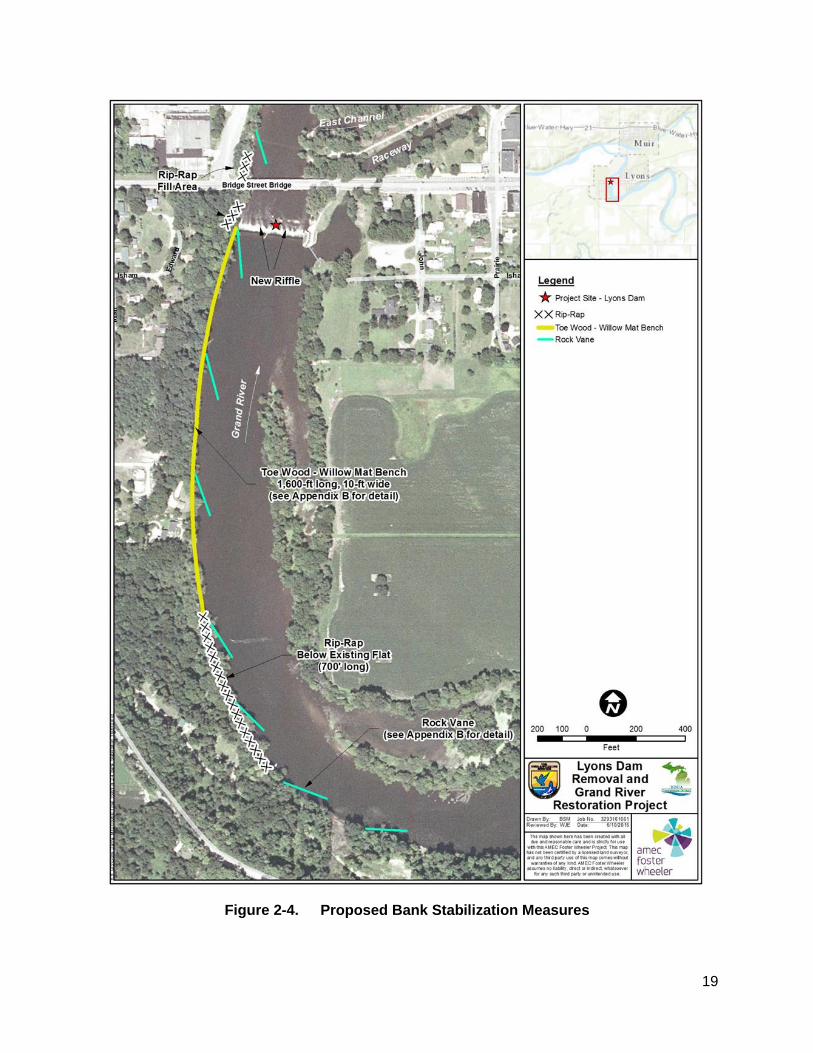
Construction activities would occur during the low flow period of mid-July to early-. Temporary staging during construction would use the material storage area shown on Figure 2-1 and the gravel parking lot near the raceway pond. The dam would be slowly breached near the center to allow for a controlled drawdown of the impoundment. Following the drawdown, the dam would be removed to an elevation of 634 ft mean sea level (msl) (North American Datum of 1988 (NAVD88). The concrete cap, reinforcement structures, and wooden crib would be removed from the river and placed in the raceway pond. The cobble and small boulders under the original rock and crib structure would be used to create a riffle with a final elevation of 635.5 ft. Following construction of the riffle, rip-rap and seven rock vanes would be placed upstream of the former dam on the left descending bank to prevent bank erosion. Upstream of the former dam, a toe wood mat consisting of layers of trees, boulders, stone, gravel, and willow mats would be placed to create a 1,600-ft long by 10-ft wide bankfull shelf. The existing fish ladder would no longer be functional and would be closed and filled. Downstream of the former dam, a straight vane would be constructed on the left descending bank to protect the abutments of the Bridge Street Bridge.
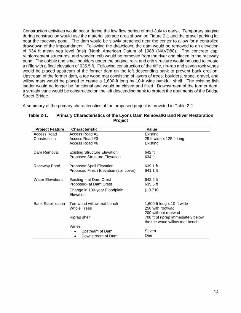
A summary of the primary characteristics of the proposed project is provided in Table 2-1.
Table 2-1. Primary Characteristics of the Lyons Dam Removal/Grand River Restoration Project
Project Feature Characteristic Value
Access Road Construction
Access Road #1 Existing Access Road #3 25 ft wide x 125 ft long Access Road #6 Existing
Existing – at Dam Crest 642.2 ft Proposed- at Dam Crest 635.5 ft
Change in 100-year Floodplain Elevation
(- 0.7 ft)
Bank Stabilization Toe-wood willow mat bench 1,600-ft long x 10-ft wide Whole Trees 250 with rootwad
200 without rootwad Riprap shelf 700 ft of riprap immediately below
the toe wood willow mat bench Vanes
Upstream of Dam
Downstream of Dam
Seven One
15
2.2.1 Construction Activities
The following narrative describes the specific actions that will be taken during the demolition and removal of Lyons Dam, filling in of the fish ladder, and channel restoration/stabilization measures that will be completed during the post-dam removal phase of the project. Project activities are illustrated in Figures 2-1 through 2-4 and would be conducted in the following sequence:
1. Construction of access roads 2. Dam removal
a. Dam deconstruction and controlled drawdown b. Raceway pond and fish ladder c. Construction of rock riffle below dam
3. Construct straight vanes above the dam 4. Construct toe wood willow mat bench 5. Construct straight rock vanes below dam
Appendix B provides a description of the sequence of work and associated supporting information as was submitted by ERP in support of the issuance of the MDEQ permit. Each of the elements of the proposed project are described below using information derived from ERP (2016).
2.2.1.1 Proposed Access Roads
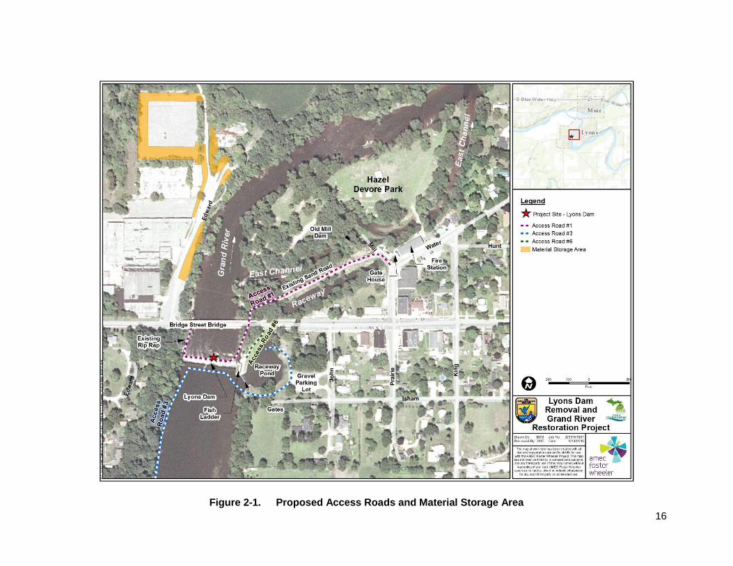
Two access roads would be constructed to support dam deconstruction and bank stabilization activities: Access Roads #3 and #6 (Figure 2-1). Both roads have steep segments where the road enters the river or enters the raceway pond where spoil from the dam will be placed. Access Road # 1 is an existing road built in an earlier phase outside of the scope of this EA. It enters the river under the east abutment of the bridge, travels past the outlet of the fishway and runs along the base of the dam. A very large hole exists downstream at the west end of the dam which would be filled with MDOT Heavy rip rap (Figure 2-3). Access Road #3 is 25 ft wide and provides access from the gravel parking lot, around the raceway pond, and across the upstream side of the dam. This road also extends upstream along the left descending bank to provide access needed to support construction of the bank stabilization measures. Access Road #6 is an existing road that provides access to the fish ladder (Figure 2-2).
2.2.1.2 Dam Removal
Dam removal would require a very heavy breaker bar attached to a large excavator. The dam would be breached at low water (less than 650 cfs) when water depths on the downstream side of the dam are 3 ft or less allowing operation of the excavator in the channel with the water level below the cab floor. The dam would be breached at the existing hole in the east center of the dam face in a sequential stepwise manner to achieve a controlled drawdown at a rate of 2 ft per incremental phase in dam demolition. Demolition debris and associated fill material would be placed within the raceway pond and fish ladder and capped with soil materials to provide a finished grade. Each of these areas would be seeded with turfgrass following the completion of grading activities.
16
Figure 2-1. Proposed Access Roads and Material Storage Area
17
Figure 2-2. Proposed Fill in Raceway Pond
18
Figure 2-3. Cross Section of Lyons Dam Illustrating Pre- and Post-Project Conditions
(Source: ERP 2016)
19
Figure 2-4. Proposed Bank Stabilization Measures
20
A cross section of the dam and its construction sequence is shown in Figure 2-3. Appendix B, Table 1 provides the volume of dam spoil to be removed. The measurements in the table were taken from a 1994 survey of the dam incorporating construction details by Ayers, Lewis, Norris and May, Inc. in drawings by Fleis and VandenBrink Engineering, Inc.
The majority of Lyons Dam would be removed (concrete cap, reinforcement structures and wood) to an elevation of 634 ft msl (NAVD 88) and then would be covered with 1.5 to 2.0 ft diameter stones to build a riffle. The concrete base of the dam would be left in-place. Removal would be accomplished with heavy equipment (excavator with breaker bar and off road trucks). To provide safe access, Access Road #1 would be used as a haul road along the face of the dam (see Figure 2-1). Following demolition, these materials would be used as the foundation for the constructed riffle. The cobble and small boulders under the original rock and crib dam and the cobble from Access Road #1 would be used to complete the riffle to final elevation of 635.5 ft. Near the middle of the channel, a 29.5-ft long section would be reduced to an elevation of 634.0 ft for passage of boats.
Access Route #3 (see Figures 2-1 and 2-2) would be constructed above the dam and within part of the existing dam footprint. The dam footprint extends east where it joins the existing stone block in front of the raceway gates and exits the river by the small park.
2.2.1.3 Straight Vanes Above the Dam
Dam removal would increase bank erosion above the dam on the west side of the river by exposing up to 5 ft of bank to normal river flows and shear stress. This is countered by construction of a bankfull bench and several straight vanes to slow water velocity against the bank and direct it toward mid channel. The straight rock vanes would be constructed (after dam removal) above Lyons Dam on the west side of the Grand River. Four upper cross vanes would be placed into an existing wooded and grass bench, while three lower cross vanes would be incorporated with the toe wood mat. The vanes would be placed approximately 295 to 360 ft apart. Heavy equipment (dump trucks and excavator) would access the river from the eastside above Lyons Dam using Access Road # 3 (Figure 2-2 and 2-4).
2.2.1.4 Toe Wood – Willow Mat Bench
The toe wood mat would be placed along the left descending bank for approximately 1,600 ft upstream of the west end of Lyons Dam. The toe wood mat (trees, stone, gravel and willow mats) would be approximately 1,600-ft long by 10-ft wide with some rip-rap extending another 700 ft below the mat. This work would be performed after dam removal and all heavy equipment (off road trucks, excavator, small bulldozer and front loader) would use Access Road # 3 (see Figure 2-2).
Approximately, 450 trees (250 rootwad and 200 non-rootwad) would be needed for construction of the toe wood mat to prevent erosion along the west side of the river channel just above the dam (see Appendix B, Figure 35-36). Trees for the toe wood mat would be mostly hardwoods, but can be of any species, and tentatively would be obtained locally.
2.2.1.5 Straight Vane Below the Dam
An 82-ft long vane would be constructed on the left descending bank to protect the bridge abutment and high river bank from erosion (see Figure 2-4). Rip-rap would be placed up to elevation 650 ft to prevent erosion. The straight vane would slow the river down and focus the water towards the center of the river, thus protecting the stream bank. Heavy equipment (excavator and off road trucks) would access the river from the eastside above Lyons Dam using
21
Access Road # 1 (Figure 2-1). Work would be done within a cofferdam enclosure with backup turbidity curtain during minor grading and rock placement.
2.3 Other Alternatives Considered
Given the current condition of Lyons Dam, the estimated cost of repairs needed to address the imminent risk of dam failure would be substantially greater than those associated with dam removal. Therefore, this option was eliminated from further consideration as it is not feasible and does not meet the purpose and need of this project.
The USFWS and Ionia Conservation District considered other alternative actions to dam removal as means to satisfy the purpose and need of the project. Previous options considered and the reasons they were not carried forward include:
Construction of a rock ramp with step-pool weirs, rather than dam removal, was not considered to be feasible due to costs and proximity to the Bridge Street Bridge.
Reconstruction of the channel to the north of Hazel Devore Island to a normal width/depth ratio was considered in order to reduce the eroding influence of the over-wide cobble riffle there. However, costs precluded this in favor of bank rip-rap protection on the island and a straight vane to direct water away from the island.
Removal of the fishway was considered, however costs and the need to seal the existing power station raceway suggested sealing the fishway and raceway gates and using the raceway pond for dam spoil disposal was not a viable option.
The current alternative for the proposed Lyons Dam removal and channel restoration reflects measures taken in the pre-removal planning process to minimize harm or take of natural resources, including federally listed and state listed mussel species, while incorporating the principals of natural channel design to restore this higher gradient reach of the Grand River. The original dam removal design plan included a partial removal of the existing dam structure, placement of several U-shaped weirs to aid fish passage, and significant dredging and filling to restore the river channel profile. The footprint of the plan encompassed over 34 ac of river bottom, including almost 15 ac of direct disturbance to snuffbox and other state listed mussels. Due to the detection of snuffbox, the plan was revised and scaled back to focus primarily on the dam removal and stabilization of the adjacent river bed and banks resulting in slightly over 18 ac of river bed disruption.
While this revised alternative included partial dam removal and placement of rock weirs for fish passage, it would still disturb nearly 10 ac of stream bottom in the areas of highest snuffbox densities. To further reduce direct impacts to this species, the partial dam removal and placement of the rock weirs alternative was replaced with the current proposal of nearly complete dam removal and placement of bed grade and bank stabilization measures. The proposed alternative reduced the overall footprint in the action area to approximately 10.4 ac, of which only 1.3 ac would have resulted in direct impact to snuffbox and its habitat. However, as a precautionary management measure, any snuffbox mussels occurring in this area were previously moved and relocated to a downstream location in accordance with a Biological Assessment (BA) and Biological Opinion (BO) previously prepared by USFWS.
The environmental impacts of Alternative A and Alternative B analyzed in detail in this EA are summarized in Table 2-2. These summaries are derived from the information and analysis provided in the Affected Environment and Environmental Consequences sections of each resource in Chapter 3.0.
22
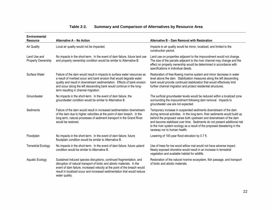
Table 2-2. Summary and Comparison of Alternatives by Resource Area
Environmental Resource Alternative A – No Action Alternative B – Dam Removal with Restoration
Air Quality Local air quality would not be impacted. Impacts to air quality would be minor, localized, and limited to the construction period.
Land Use and Property Ownership
No impacts in the short-term. In the event of dam failure, future land use and property ownership condition would be similar to Alternative B.
Land use on properties adjacent to the impoundment would not change. The size of the parcels adjacent to the river channel may change and the effect on property ownership would be determined in accordance with specifications in individual deeds.
Surface Water Failure of the dam would result in impacts to surface water resources as a result of riverbed scour and bank erosion that would degrade water quality and result in downstream sedimentation. Effects of bank erosion and scour along the left descending bank would continue in the long-term resulting in channel migration.
Restoration of free-flowing riverine system and minor decrease in water level above the dam. Stabilization measures along the left descending bank would provide continued stabilization that would effectively limit further channel migration and protect residential structures.
Groundwater No impacts in the short-term. In the event of dam failure, the groundwater condition would be similar to Alternative B.
The surficial groundwater levels would be reduced within a localized zone surrounding the impoundment following dam removal. Impacts to groundwater use are not expected.
Sediments Failure of the dam would result in increased sedimentation downstream of the dam due to higher velocities at the point of dam breach. In the long-term, natural processes of sediment transport in the Grand River would be restored.
Temporary increase in suspended sediments downstream of the dam during removal activities. In the long-term, finer sediments would build up behind the proposed vanes both upstream and downstream of the dam and become stabilized over time. Sediments do not present additional risk to the river system ecology as a result of the proposed dewatering in the raceway nor to human health.
Floodplain No impacts in the short-term. In the event of dam failure, future floodplain condition would be similar to Alternative B.
Lowering of 100-year flood elevation by 0.7 ft.
Terrestrial Ecology No impacts in the short-term. In the event of dam failure, future upland condition would be similar to Alternative B.
Use of trees for toe wood willow mat would not have adverse impact. Newly exposed shoreline would result in an increase in terrestrial vegetation and available habitat for wildlife.
Aquatic Ecology Sustained induced species disruptions, continued fragmentation, and disruption of natural transport of biotic and abiotic materials. In the event of dam failure, increased velocity at the point of the breach would result in localized scour and increased sedimentation that would reduce water quality.
Restoration of the natural riverine ecosystem, fish passage, and transport of biotic and abiotic materials.
23
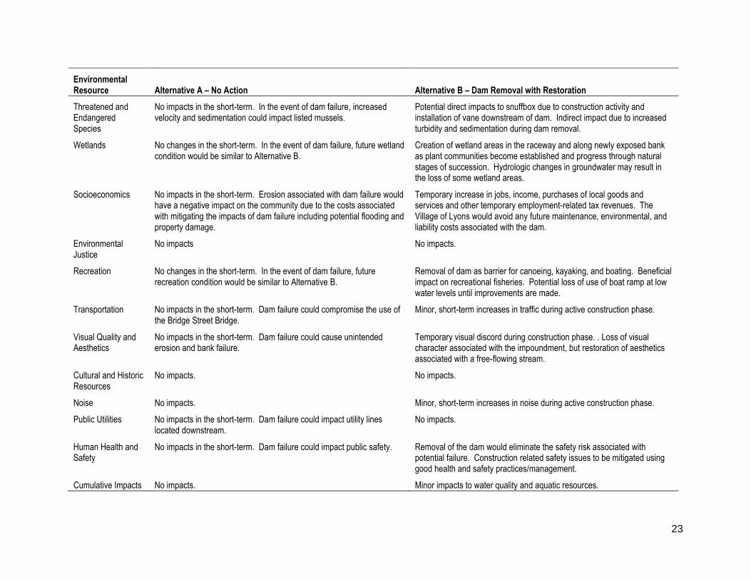
Environmental Resource Alternative A – No Action Alternative B – Dam Removal with Restoration
Threatened and Endangered Species
No impacts in the short-term. In the event of dam failure, increased velocity and sedimentation could impact listed mussels.
Potential direct impacts to snuffbox due to construction activity and installation of vane downstream of dam. Indirect impact due to increased turbidity and sedimentation during dam removal.
Wetlands No changes in the short-term. In the event of dam failure, future wetland condition would be similar to Alternative B.
Creation of wetland areas in the raceway and along newly exposed bank as plant communities become established and progress through natural stages of succession. Hydrologic changes in groundwater may result in the loss of some wetland areas.
Socioeconomics No impacts in the short-term. Erosion associated with dam failure would have a negative impact on the community due to the costs associated with mitigating the impacts of dam failure including potential flooding and property damage.
Temporary increase in jobs, income, purchases of local goods and services and other temporary employment-related tax revenues. The Village of Lyons would avoid any future maintenance, environmental, and liability costs associated with the dam.
Environmental Justice
No impacts No impacts.
Recreation No changes in the short-term. In the event of dam failure, future recreation condition would be similar to Alternative B.
Removal of dam as barrier for canoeing, kayaking, and boating. Beneficial impact on recreational fisheries. Potential loss of use of boat ramp at low water levels until improvements are made.
Transportation No impacts in the short-term. Dam failure could compromise the use of the Bridge Street Bridge.
Minor, short-term increases in traffic during active construction phase.
Visual Quality and Aesthetics
No impacts in the short-term. Dam failure could cause unintended erosion and bank failure.
Temporary visual discord during construction phase. . Loss of visual character associated with the impoundment, but restoration of aesthetics associated with a free-flowing stream.
Cultural and Historic Resources
No impacts. No impacts.
Noise No impacts. Minor, short-term increases in noise during active construction phase.
Public Utilities No impacts in the short-term. Dam failure could impact utility lines located downstream.
No impacts.
Human Health and Safety
No impacts in the short-term. Dam failure could impact public safety. Removal of the dam would eliminate the safety risk associated with potential failure. Construction related safety issues to be mitigated using good health and safety practices/management.
Cumulative Impacts No impacts. Minor impacts to water quality and aquatic resources.
24
3.0 Affected Environment and Environmental Consequences
This section describes the baseline environmental conditions potentially affected by the proposed removal of Lyons Dam and an assessment of impacts of the project on the environmental resources identified. The study area for determining impacts to most natural resources, noise and the physical environment studied in this Draft EA included the project site and resources within a 3-mi radius.
Where the effects of the proposed action extend beyond the 3-mi radius, a larger study area was used for that specific analysis. For example, the socioeconomic analysis considered data at the county level as this is the area where most of the construction workforce would be located. For impacts to cultural and historic resources, the Area of Potential Effects was limited to the project site and any historic properties within a half-mile radius.
The USFWS and Ionia Conservation District considered all appropriate environmental factors potentially influenced by the proposed project as part of this analysis. From this review, the EA was able to focus the environmental review on specific resources and eliminate others from further evaluation.
The Draft EA does not contain detailed discussions on resources not found in the study area, or that would not be impacted by any of the alternatives. These include:
Geology. The project area is located largely in a river and would not include any below ground disturbance that would impact geologic resources.
Prime Farmland. The project area is located largely in a river and any work in upland areas would be on previously disturbed lands, therefore no impacts to prime farmland soils are anticipated.
A discussion of resources retained for detailed analysis is provided in the following sections.
3.1 Air Quality
3.1.1 Affected Environment
The Clean Air Act regulates the emission of air pollutants and, through its implementing regulations, establishes standards (National Ambient Air Quality Standards [NAAQS]) for several criteria pollutants that are designed to protect the public health and welfare with an ample margin of safety. The criteria pollutants are ozone, particulate matter, carbon monoxide, nitrogen oxides, sulfur dioxide and lead. Specified geographic areas are designated as attainment, nonattainment or unclassifiable for specific NAAQS. Areas with ambient concentrations of criteria pollutants exceeding the NAAQS are designated as nonattainment areas, and new emissions sources to be located in or near these areas are subject to more stringent air permitting requirements.
Lyons Dam is located in Ionia County. According to the USEPA’s Green Book (USEPA 2016b) and MDEQ (MDEQ 2016) websites, this county is in attainment for all USEPA and state of Michigan criteria air pollutants, except lead. A small area (less than 1 mi2) located in the city of Belding in Ionia County does not meet the 2008 lead standard. The Lyons Dam project area is located over 20 mi to the southeast of Belding and is, therefore, not affected by the nonattainment status in the Belding area.
25
3.1.2 Environmental Consequences
3.1.2.1 Alternative A – No Action Alternative
There would be no change in the current conditions under this alternative, therefore there would be no impact to air quality.
3.1.2.2 Alternative B – Dam Removal with Restoration
The proposed project will have no long-term impacts on air quality. Construction of the project may cause a temporary reduction in local ambient air quality because of emissions generated by construction equipment. Equipment operating on the construction site would emit pollutants that contribute to temporary and localized increased levels of criteria pollutants such as carbon monoxide, nitrogen oxides, and ozone. Because equipment use is relatively limited (excavators, trucks, etc.) and of relatively short duration (up to four months), the emissions from construction vehicles and related equipment should have an insignificant, temporary impact to local air quality. No changes in local or regional air quality are likely to occur with the construction and operation of the proposed project.
3.2 Land Use and Property Ownership
3.2.1 Affected Environment
The Grand River runs through eight counties across Michigan, rising in Hillsdale County in the southern portion of the state and generally flows to the northwest to its outlet to Lake Michigan. The river connects rural, upstream agricultural communities with sprawling suburban areas, diverse, industry-dotted urban zones, and Lake Michigan. As shown in Figure 3-1, land use within the area surrounding Lyons Dam (3-mi radius) consists primarily of cultivated crops, forested areas, and developed open space. Within the study area, both banks of the river are tree-lined with agricultural, forested areas, and residential uses located inland of the riparian corridor. Property ownership along the water’s edge is mostly privately owned parcels with the exception of the parks. The Bridge Street Bridge is located just downstream of the dam and an abandoned industrial area and parking lot is situated just downstream of the bridge.
Lyons Dam, the encompassing lands, and the associated features are owned by the Village of Lyons with the exception of the fish ladder, which is owned by the MDNR. Hazel Devore Island and the park located within it are also owned by the Village of Lyons. Other land within the project area is primarily rural residential and privately-owned.
3.2.2 Environmental Consequences
3.2.2.1 Alternative A – No Action Alternative
Under the No Action Alternative, Lyons Dam is expected to remain in-place for some indeterminate short-term period. For that period land use and property ownership conditions would remain unchanged. However, because the dam continues to deteriorate and is in danger of failure, it is expected that the future land use and property ownership condition is similar to that described below for Alternative B.
26
Figure 3-1. Land Use Land Cover within the Vicinity of Lyons Dam
27
3.2.2.2 Alternative B – Dam Removal with Restoration
The proposed removal of Lyons Dam would result in the transformation of this river from impounded to free-flowing. Most of the activities associated with Alternative B would occur within the channel of the Grand River, and there would be no change in surrounding land use. However, as the impounded waters recede to the original contours of the river after dam removal, land formerly submerged under water would be converted to barren streambank consisting of open space. Because the lands adjacent to the impoundment are currently considered open space and would continue to be designated as such, there would be no change in land use. Properties adjacent to the impoundment would retain their current frontage, but it would be altered in character to a free-flowing stream and associated floodplain. The raceway pond would be filled with dam spoil material and covered with a 2-ft clay cover which would be covered with top soil and seeded. There are no plans for future development of this area, and it would remain as a greenspace for the Village of Lyons.
As the impoundment draws down, the resulting upland areas adjacent to the river channel would increase. The size of the parcels adjacent to the river channel may change and the effect on property ownership would be determined in accordance with specifications in individual deeds. However, as removal of the dam would drop bankfull elevation by 2.4 ft and lower summertime water levels by 4 to 5 ft, the impact on property ownership is expected to be minimal.
Property values for homes and other nearby structures are based on condition and age of structures, square footage, development trends, and other factors unrelated to the existence or non-existence of the dam. However, there is some evidence that indicates that shoreline frontage along small impoundments confers no increase in residential property value compared to frontage along free-flowing streams. Furthermore, residential property located in the vicinity of a free-flowing stream is more valuable than similar non-frontage property in the vicinity of small impoundment (American Rivers and Trout Unlimited 2002 and Provencher et al. 2008). Depending on the individual property owner’s perspective, the dam can be viewed as an asset or liability, and restoring the river to a free-flowing state can be viewed differently depending on individual perspectives.
The removal of the dam does not increase the risk of flooding for properties adjacent to the impoundment. Severe erosion of the banks of the river at the west end of the dam is threatening property located above the high bank and the west abutment of the Bridge Street Bridge. Restoration activities proposed under this alternative would reduce erosion in these areas and therefore have a long-term beneficial impact on these properties. The drop in bankfull water levels with removal of the dam would also have a positive impact on private lands located upstream, including those used for agriculture. Under current conditions flood waters remain trapped behind a natural levee that occurs on the right descending bank just upstream of the dam. Lowering of the bankfull elevation would remove the influence of this levee, therefore having a positive impact on the agricultural use of the adjoining land. Therefore, the proposed action is anticipated to result in an indirect beneficial impact to surrounding properties.
28
3.3 Water Resources
3.3.1 Surface Water
3.3.1.1 Affected Environment
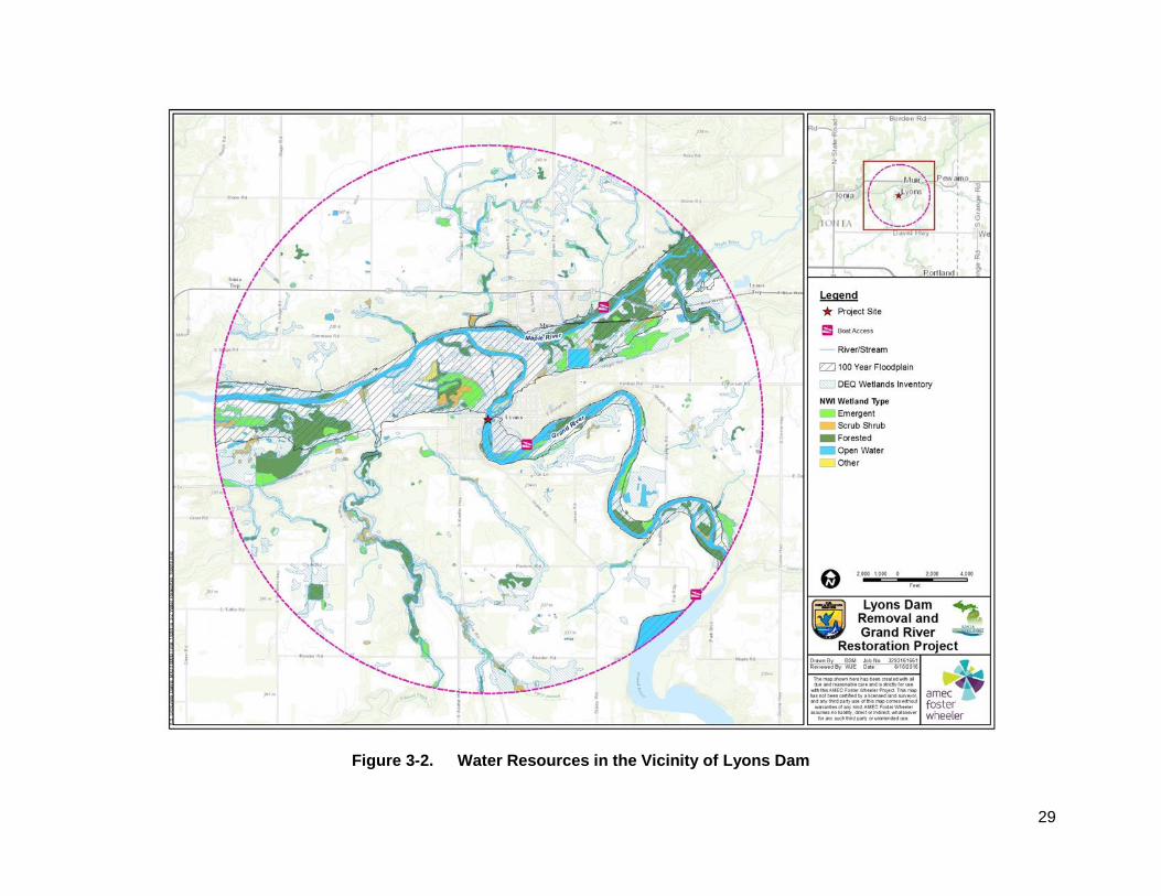
The Grand River is the longest river in Michigan and runs approximately 260 mi until it drains into Lake Michigan. Its watershed drains an area of 5,572 mi2 and the contributing drainage area to the Grand River at Lyons is 1,758 mi2. The river includes several dams along its length, with Lyons Dam being the second lowest. The next intact dam upstream of Lyons Dam is the Webber Dam in Portland, Michigan. The portion of the watershed upstream Webber Dam is approximately 33 mi2. The 6th Street Dam in downtown Grand Rapids is located approximately 54 mi downstream of Lyons Dam. Water resources in the vicinity of Lyons Dam are identified on Figure 3-2.
The potentially affected environment is considered to be the lentic environment of the impounded area behind the dam and the lotic (flowing water) sections of the Grand River upstream and downstream of the dam. The area upstream includes the full extent of the impoundment and river reach continuing upstream for 2.8 mi, at which point stream water velocities diminish in response to changes in stream gradient due to the Lyons Dam and associated deposited sediment (ERP 2016, Appendix B). The area downstream of the dam includes the extent of the river.
The federal Clean Water Act (CWA) Section 303(d) requires that states develop a list of the streams and lakes that need additional pollution controls because they are water quality limited or are expected to exceed water quality standards in the next two years. The portion of the Grand River upstream of Lyons Dam was listed by MDEQ in its 2014 303(d) report as not supporting fish consumption due to polychlorinated biphenyls (PCBs) in water column and both PCBs and mercury in fish tissue (MDEQ 2016a).
3.3.1.2 Environmental Consequences
3.3.1.2.1 Alternative A – No Action Alternative
Under this alternative, Lyons Dam would be subject to short-term stabilization measures and would remain in-place for some indeterminate short-term period of time. During this period, there would be no change in current conditions under this alternative. However, the dam continues to deteriorate and is in danger of failure. Failure of the dam would result in impacts to surface water resources as a result of riverbed scour and bank erosion that would degrade water quality and result in downstream sedimentation. A natural flow regime would become reestablished in the long-term as described for Alternative B. However, under this alternative no restoration efforts would be implemented to stabilize the left descending bank or to protect the downstream bridge abutment from erosion. As a result, long-term channel migration may be expected to occur under this alternative. Effects of bank erosion and scour along the left descending bank would, therefore, continue in the long-term.
29
Figure 3-2. Water Resources in the Vicinity of Lyons Dam
30
3.3.1.2.2 Alternative B – Dam Removal with Restoration
Under Alternative B, removal of the dam would restore this portion of the Grand River to a more free-flowing riverine system. The removal of the dam would effectively reconnect 15.5 mi of habitat upstream with 54 mi of habitat downstream and would provide passage for fish and other aquatic species. Long-term impacts include the lowering of bankfull water levels above the dam by 2.4 ft and summertime water levels by 4 to 5 ft. The proposed riffle structure at the dam location would provide hydrologic connections to support ecological communities (i.e., adjacent wetland community types), to maintain appropriate velocities and flow depths for fish passage, and limit erosion downstream. Additionally, stabilization measures along the left descending bank would result in the redirection of scouring flow away from the bank, thereby minimizing erosion, water quality degradation and continued bank failure. Such measures would provide continued stabilization that would effectively limit further channel migration to the west, thereby enhancing protection to residential structures located above the bank, west of the dam. Therefore, long-term impacts to surface waters and hydrology are predicted to be beneficial.
3.3.2 Groundwater
3.3.2.1 Affected Environment
Groundwater resources within the vicinity of the project area include the surficial aquifer and water bearing formations. Surficial aquifers are typically shallow, unconsolidated groundwater systems that are typically unproductive for water supply purposes. They consist chiefly of stratified sand and gravel, icecontact deposits, and alluvium. Water is withdrawn from easily installed shallow wells for domestic and stock-watering uses. The aquifer system stores water and transmits it either along short flow paths to streams, thus sustaining base flow, or downward to underlying aquifers, thus providing recharge to the underlying aquifers where they occur at the bedrock surface (U.S. Geological Survey [USGS] 1992).
Surficial aquifers in the project area also support wetland communities. In particular, it is expected that localized surficial groundwater is influenced by surface water elevations of the Grand River upstream of Lyons Dam. As such it is expected that some of the wetlands upstream of the dam are perpetuated by a hydrology that is in part, driven by the surficial aquifer.
More substantial water-bearing formations are represented by aquifers typically associated with sand and gravel deposits that can support public and domestic water supply. Groundwater for the Village of Lyons is obtained from two groundwater wells, each over 400-ft deep that draw water from the Saginaw Formation (Village of Lyons 2016). The Saginaw Formation is part of the Pennsylvanian aquifer which is present only in the central part of the Lower Peninsula of Michigan. This aquifer is the fourth largest source of groundwater in the region and consists primarily of sandstone and is the principal bedrock aquifer in the Lower Peninsula (USGS 1992). In addition to the Lyons public water supply wells, 11 additional wells were identified in the project vicinity that are designated for domestic use. Nine of these wells were located in deeper formations (139 ft below ground surface [bgs] to 360 ft bgs), whereas two wells were established at lower levels (33 and 55 ft bgs) (MDEQ 2016b).
Groundwater quality of water provided by the Village of Lyons is good. The Village of Lyons water system was put into service in 1972, and no lead service lines were installed. Routine sampling and analyses performed by the Village of Lyons has demonstrated that the groundwater system
31
had no violations and that the quality meets or exceeds all federal and state requirements (Village of Lyons 2016).
3.3.2.2 Environmental Consequences
3.3.2.2.1 Alternative A – No Action Alternative
Under the No Action Alternative, Lyons Dam is expected to remain in-place for some indeterminate short-term period. For that period, groundwater conditions would remain unchanged. However, because the dam continues to deteriorate and is in danger of failure, it is expected that the future groundwater condition is similar to that described below for Alternative B. As such, there may be narrow localized zones around the existing impoundment where the surficial water table is reduced that may influence the hydroperiod of adjacent dependent wetlands. However, no effects to groundwater users are expected to occur under this alternative.
3.3.2.2.2 Alternative B – Dam Removal with Restoration
Under this alternative, the dam would be removed and the impoundment behind Lyons Dam would be drained to a restored gradient of the Grand River. Because of the localized effect of the impoundment upstream of Lyons Dam on localized surficial groundwater, some reduction of the potentiometric surface may be expected in the areas immediately adjacent to the former impoundment. Consequently, this change in the near-surface hydrology (particularly which is due to backwater effect from the impoundment) is also expected to result in parallel changes in the hydroperiod of dependent wetlands. However, because the groundwater discharge patterns are complex and often dependent on local stratigraphy (e.g., the presence of clay lenses in the glacial till), the potential impact of dewatering on discharge from the valley walls is difficult to predict with certainty. Following dam removal it is expected that any surficial groundwater would re-establish a new equilibrium with the surface water of the restored river flowline. Therefore, the surficial groundwater levels are expected to be reduced within a localized zone surrounding the impoundment following dam removal.
As described above, public and domestic water supply wells in the vicinity of the project area are mostly developed at within deeper formations that are not influenced by surface water conditions. For the two wells established in shallower depths, depths are substantially below the proposed flow line of the restored Grand River and are not expected to be influenced or dewatered by elimination of the impoundment. Therefore, impacts to groundwater use are not expected under this alternative.
3.3.3 Sediments
3.3.3.1 Affected Environment
Information regarding sediment characteristics within the project area is summarized below and includes the results from two separate sampling events by MDEQ in 2009 as well as visual observations of the Grand River as summarized by ERP (2016, Appendix B). Supplemental sampling within backwater areas was also performed in 2016 as described below.
The river valley is characterized by a numerous gravel pits and unusually coarse gravel and cobble riffles. Both riffle and pool areas between Webber Dam and Lyons Dam are characterized by gravel, cobble and boulders in the riffles, and gravel and cobble in the pools. Using U.S. Army Corps of Engineers methods, it was estimated that the annual sediment transport on the Grand River is approximately 95,000 cubic yards. This would equate to a layer of sand approximately 0.7-ft deep throughout the reservoir bottom for 2.3 mi upstream (ERP 2016). However, surveys
32
of the channel upstream of Lyons Dam revealed very little sand or other fine sediments immediately above the dam or within the upstream impoundment. Gravel, cobble, and boulders were identified as the dominate river substrates. The reach of the Grand River between Webber Dam and Lyons Dam is considered to be supply-limited due to the upstream trapping of sediment behind the large Webber Dam and to a limited extent the partially breached Wagar Dam. Any fine sediment (fine sand) that carried over the dams during high water is suspended within the water column and is considered to be negligible. The only location sampled in 2009 that had finer sediment was immediately upstream of the dam on the far east side in a backwater area. Sieving of those samples found over 95 percent sand in that location (ERP 2016).
Supplemental sediment samples were collected in 2016 in response to public comments made at the scoping meeting in February 2016. The concern expressed at the meeting was that lands exposed by impoundment drawdown following dam removal may contain elevated levels of chemical constituents that may pose a risk or liability to property owners. In order to characterize sediments of potentially exposed backwater areas, shallow sediment samples were collected from five backwater areas (Backwater Areas 1 through 5) and the existing raceway (Figure 3-3). This sediment sampling was performed as a screening process to identify constituents of potential concern (COPCs) that may occur once the sediment is exposed and dewatered. Previous sediment characterization from samples collected at other locations within the impoundment reportedly did not identify any COPCs (MDEQ 1995 and Solutions through Science and Engineering Consultants, Inc. 2000).
Sample collection methodology and the analyses performed are presented in Appendix D, and the results are summarized below.
None of the samples contained volatile organic compounds, semi-volatile organic compounds, PCBs, pesticides or herbicides at concentrations above their respective laboratory method detection limits. For metals, no results were found to exceed the published soil Direct Contact Criteria. No results were found to exceed the probable effect concentration (PEC). The ecological screening levels for sediments (Eco-SSL) and threshold effect concentrations (TEC) set forth by USEPA were exceeded for cadmium and copper in two different locations (BW-01-Composite and RW-01-Composite, respectively):
Cadmium was detected at 1,400 micrograms per kilogram (µg/kg), slightly above both the Statewide Default Background Level of 1,200 µg/kg and the TEC Eco-SLL of 990 µg/kg, but was detected below the Statewide Default Background Level and the Eco-SSL/TEC in the duplicate sample collected from the BW-01-Composite location (790 µg/kg). The average concentration of cadmium detected in the seven sediment samples (including the duplicate) was 780 µg/kg.
Copper was detected in the raceway sediment sample (RW-01 Composite) at 91,000 µg/kg, which is above the Statewide Default Background Level of 32,000 µg/kg and the TEC Eco-SSL of 31,600 µg/kg. The average concentration of copper detected in the seven sediment samples was 28,486 µg/kg.
The average concentration of all Michigan-ten metals results, including cadmium and copper were below their respective Eco-SSL/TEC. It is likely that the levels of metals detected are representative of naturally occurring metals located throughout the river system, as concluded in March 1995 and May 2000 based on then available results.
3.3.3.2 Environmental Consequences
3.3.3.2.1 Alternative A – No Action Alternative
Under the No Action Alternative, Lyons Dam is expected to remain in-place for some indeterminate short-term period, during which the current sediment conditions would remain unchanged. However, the dam continues to deteriorate and is in danger of failure. Failure of the dam would result in increased scour and sedimentation downstream of the dam due to higher velocities at the point of dam breach. However, it is anticipated that the sediment condition described below for Alternative B would be re-established in the long-term. Specifically, as the impoundment sediments transported downstream, the total suspended solids and turbidity levels would gradually diminish with distance and would not be discernable from naturally occurring sediment beyond the area immediately downstream of the dam. The natural processes of sediment transport to the Grand River would be restored, resulting in the re-establishment of the equilibrium in natural sediment transport.
3.3.3.2.2 Alternative B – Dam Removal with Restoration
Removal of Lyons Dam would result in temporary disturbance of the sediments which have been deposited upstream of the dam. Sediment management activities are integrated in the proposed action, including performing work during low water and gradual drawdown of the impoundment.
Sediment suspension in the Grand River as a result of construction activities is anticipated to be less than 5 percent of bankfull flows because the Lyons reach of the Grand River is sediment limited by Webber Dam. Additional sedimentation caused by construction equipment in the river would be limited by the large amount of cobble, gravel, and boulder it would be operating on.
The amount of sediment in the water flowing downstream from the dam would possibly increase for a short duration immediately following dam removal and would depend on the rate of discharge and volume of water discharging. Because most of the substrate in the impoundment upstream of the dam has been determined to be coarse (gravel, cobble, boulders), downstream sediment transport is expected to be minimal. Nonetheless, some downstream transport of impounded sediments and substrates are expected as part of a normalization of sediment transport processes. Any elevation of total suspended solids and turbidity levels during construction would gradually diminish with distance and would not be discernable from naturally occurring sediment beyond the area immediately downstream of the dam. Eventually, the amount of sediment in river water would reach a stable condition with normal river flows. The first high water event following dam removal would likely flush additional sediment from the formerly impounded area to the downstream river channel, with subsequent high water events likely have decreasing sediment concentrations. The amount of sediment moving downstream in the future would in part depend on natural events such as weather, rainfall and snowmelt events.
After the removal of Lyons Dam, the channel immediately downstream from the dam would be expected to exhibit the greatest changes. Sediments transported below the dam would be expected to first go to the over-wide riffle where they would mix with the existing sand on the island side of the river. When bankfull flows occur, that sand would be picked up in the normal bankfull-flow transport sequence and be carried down river to the confluence of the Maple and
35
Grand rivers. Sediments may also accumulate at the point bar on the west side of the river just downstream of Hazel Devore Island (across from the existing vane and bench). The point bar is dynamically in balance due to the terrace on the east side of the river, however it would tend to move very slowly downstream over time with little change in its shape (ERP 2016).
Finer sediments would build up behind the proposed vanes both upstream and downstream of the dam (between the vane and the bank) and become stabilized over time as plant communities become established and progress through natural stages of succession.
Based on the supplemental sediment samples collected, they do not appear to present additional risk to the river system ecology as a result of the proposed dewatering in the raceway nor to human health due to exposure to sediment after dam removal. The concentration of cadmium and copper detected in two of the samples do not exceed the MDEQ’s Direct Contact Criteria. In addition, the sediment in the raceway is not intended to be disturbed or removed.
3.3.4 Floodplain
3.3.4.1 Affected Environment
As a federal agency, USFWS is subject to the requirements of Executive Order (EO) 11988, Floodplain Management. The objective of EO 11988 is “…to avoid to the extent possible the long- and short-term adverse impacts associated with the occupancy and modification of floodplains and to avoid direct and indirect support of floodplain development wherever there is a practicable alternative.” The EO is not intended to prohibit floodplain development in all cases, but rather to create a consistent government policy against such development under most circumstances. The EO requires that agencies avoid the 100-year floodplain unless there is no practicable alternative.
A review of the Federal Emergency Management Agency Flood Insurance Rate Map for the project area (Panel Number 26067C0202D), indicates that the entire project area is located within the 100-year floodplain of the Grand River (see Figure 3-2). This area is categorized as Zone A, which indicates that no base flood elevations have been determined. Within a 3-mi radius from the dam, there are a total of 2,985.6 ac within the 100-year floodplain.
3.3.4.2 Environmental Consequences
3.3.4.2.1 Alternative A – No Action Alternative
Under the No Action Alternative, Lyons Dam is expected to remain in-place for some indeterminate short-term period. During that period, current conditions would remain unchanged and both nuisance flooding and major flooding events would continue for businesses and residential properties along the project area. However, because the dam continues to deteriorate and is in danger of failure, it is expected that the future floodplain condition is similar to that described below for Alternative B.
3.3.4.2.2 Alternative B – Dam Removal with Restoration
Because the Grand River is large (300 ft across) with a 100-year discharge of 27,000 cfs, the proposed changes in channel geometry and fill material would have a small effect on flood elevation. Therefore, the proposed action, including removal of the dam and installation of the toe wood willow mat structure would lower the 100-year flood level by approximately 0.70 ft (ERP 2016). Alternative B would, therefore, not adversely affect regulatory floodplains.
36
The decrease in the floodplain elevation would provide some relief to the private lands upstream of the dam during high water events. Under existing conditions, high flow conditions result in the flooding of adjacent lands both upstream and downstream of Lyons Dam. Low natural levees along the right descending bank prevent the water from receding from the adjacent lands following flood events thereby extending the duration of flooding. Following dam removal however, it is expected that the frequency of flooding of these adjacent lands will be reduced for smaller flood events.
3.4 Terrestrial Ecology
3.4.1 Affected Environment
The project area is located in the Lansing Loamy Plain Level IV ecoregion, which covers a broad area in central Lower Michigan (USEPA 2010). This ecoregion consists of mostly gently rolling ground moraine; well-drained hills alternate with poorly-drained linear depressions. Prior to European settlement, the ground moraine supported broad areas of beech-sugar maple forest. Associated species included basswood, black maple, red oak, and white ash. Oak-hickory forests grew on the drier end moraine and outwash habitats. The poorly-drained depressions and riparian floodplains contained American elm, red ash, silver maple, tamarack, and swamp white oak as well as areas of wet prairie.
Land use/land cover based on the National Land Cover Database within a 3-mi radius of the dam is summarized in Table 3-1 and shown in Figure 3-1. Presently, the land cover of the region is dominated row crops and pasture, with smaller forested areas associated with isolated woodlots, riparian corridors and steeply sloping end moraines that still support patches of forest. Land cover within the radius consists of mostly cultivated crops (42.3 percent), deciduous forest (19.9 percent), and hay/pasture (15.1 percent).
Table 3-1. Land Use/Land Cover within a 3-Mile Radius
Land Cover Type Area (Ac) Percent of
Area
Developed, High Intensity 9.1 0.1
Shrub/Scrub 24.8 0.1
Developed, Medium Intensity 50.5 0.3
Emergent Herbaceous Wetlands 60.5 0.3
Evergreen Forest 85.8 0.5
Mixed Forest 93.0 0.5
Barren Land 124.3 0.7
Grassy/Herbaceous 129.8 0.7
Developed, Low Intensity 393.6 2.2
Open Water 514.1 2.8
Developed, Open Space 823.8 4.6
Woody Wetlands 1795.5 9.9
Hay/Pasture 2722.7 15.1
Deciduous Forest 3607.3 19.9
Cultivated Crops 7652.8 42.3
Grand Total 18,087.4 100.0
37
In the immediate vicinity of the project area, land cover includes wooded wetlands (associated with the Grand River valley), mixed forest and evergreen forest (associated with uplands), and cultivated crops. These habitats support a diverse wildlife community characterized by waterfowl (ducks, geese), swans, wading birds (sandpipers), shorebirds (herons), raptors (hawks, bald eagle), wild turkey, pheasant, various mammal species (whitetail deer, cottontail rabbit, and other rodents), and herpetofauna (snakes, frogs, toads, turtles, salamanders).
The upland communities in the vicinity of the Grand River also support a diversity of wildlife, but are characterized by fewer water-dependent species and more taxa that are typically associated with more mesic (moist) and drier habitats. Bird communities in these areas are dominated by species that frequent trees and shrubs such as songbirds, woodpeckers and other cavity-nesting species, as well as neotropical migratory birds (warblers) and upland game birds (wild turkey). Additionally, these uplands support a different assemblage of mammals including a variety of bat species, rodents (groundhog, squirrels, chipmunks, white-footed mouse, etc.), and carnivorous species (red and gray fox, raccoon, striped skunk, etc.).
EO 13112 (Invasive Species) defines an invasive species as one that is not native to the local ecosystem and whose introduction does or is likely to cause economic or environmental harm or harm to human health. Invasive plants can include trees, shrubs, vines, grasses, ferns and forbs. Invasive plants observed in the immediate project area include a Japanese smartweed population in the riparian area of the raceway pond. This species has the potential to affect the native plant communities adversely because of its ability to spread rapidly and displace native vegetation.
3.4.2 Environmental Consequences
3.4.2.1 Alternative A – No Action Alternative
There would be no change in the current conditions of terrestrial resources under this alternative in the short-term. However, as the dam continues to deteriorate and is in danger of failure, the lowering of the water level behind the dam after the dam fails would result in conditions similar to Alternative B. The exposure of backwater areas and new shoreline would likely re-vegetate and develop variously as transitional upland/riparian zones and as emergent or woody wetlands over time.
3.4.2.2 Alternative B – Dam Removal with Restoration
The proposed action would have limited impacts to terrestrial resources as most work would be performed within the river. Conservation measures incorporated into the project include the use of existing roads where possible to eliminate the need for vegetation clearing.
The proposed project would include the removal of 450 trees for the construction of the toe wood willow mat to prevent erosion along the west side of the river just above the dam. These trees would be obtained within a 2-mi radius, which would slightly decrease the overall amount of vegetation and forested habitat available within the vicinity of the project. However, relative to the amount of deciduous forest within the 3-mi radius (3,607.3 ac), the removal of 450 trees is not considered to be a notable impact to available resources.
The lowering of the pool elevation behind the dam by approximately 2.4 ft and by 4 to 5 ft in the summertime would result in the exposure of previously flooded/saturated backwater areas and new riverine shoreline. While the newly exposed land may be barren or sparsely vegetated in the
38
short-term, it would likely re-vegetate and develop variously as transitional upland/riparian zones and as emergent or woody wetlands over time. Upstream of the dam, the sediment remaining in-place behind the former dam and along the installed vanes is likely to be re-vegetated and stabilized, especially over time as plant communities become established and progress through natural stages of succession. Therefore, the proposed action would result in a slight increase in terrestrial vegetation and available habitat for wildlife in the long-term, resulting in a beneficial impact to terrestrial resources.
3.5 Aquatic Ecology
3.5.1 Affected Environment
The portion of the Grand River above Lyons Dam is a lentic aquatic habitat that is characterized by slow flow, greater depth, and the predominance of depositional substrates relative to the flowing environments of the Grand River. Habitat within this section of the river consists of the open water pelagic zone, benthic habitats, and the fringing zone of submersed aquatic vegetation. The submersed aquatic vegetation within the river above the dam provides useful habitat and structure that may be used by invertebrates and fish for feeding, spawning or nursery areas.
Within the project area, the Grand River is home to a variety of fish species, including many targeted for recreational fishing. Common species include smallmouth bass, largemouth bass, walleye, northern pike, white sucker, logperch, channel catfish, and rock bass. Other species found within this reach include bluntnose minnow, greater redhorse, greenside darter, brook silverside, Johnny darter, rosyface shiner, black crappie, greater redhorse, sand shiner, rainbow dater, bluegill, and river redhorse (MDNR 2005). In its current condition, the dam allows salmonids to ascend upstream through a fish ladder and ascend the river to the city of Lansing. However, native warmwater fish species do not use the ladder, effectively blocking them from upstream movement. Of additional concern is the limitation of movement of the logperch, which is a known host species to the larval form of the endangered snuffbox mussel. As a result of the limited distribution of the logperch, snuffbox distribution is also limited to downstream areas (see Section 3.6 for further discussion of snuffbox). The dam acts as an effective barrier for other species in a similar manner that cannot overcome the flow or vertical physical barrier that prevents their upstream movement.
The portion of the Grand River just below Lyons Dam was surveyed for unionid species in 2013, and almost 300 live specimens representing 20 different species were discovered (Woolnough and Barnett 2013). The most commonly encountered species included plain pocketbook, threeridge, and snuffbox. Other species found included elktoe, creek heelsplitter, mapleleaf, pimpleback, and creeper. The invasive aquatic species, Chinese mystery snail and Asiatic clam, were also found immediately below the dam. Overall the survey found that the density and species richness of live unionids increases significantly downstream of the dam.
3.5.2 Environmental Consequences
3.5.2.1 Alternative A – No Action Alternative
Under the No Action Alternative, the current conditions would continue to exist in the indeterminate short-term. In particular, the presence of Lyons Dam would continue to impede fish passage and the movement of reproductive propagules and food sources from upstream areas. However, the dam continues to deteriorate and is in danger of failure. In the event of a breach, increased velocity at the point of the dam breach would result in localized scour and
39
increased sedimentation which would have a negative impact on aquatic habitat and resident aquatic species. Re-suspension of sediments could increase turbidity and reduce water quality; deposition of silt could smother less mobile fish species (darters, etc.), mussels, benthic invertebrates and/or their habitats. However, in the long-term it is expected that the aquatic condition would be similar to that described below for Alternative B. While some in-stream habitat would be enhanced by the restoration of the natural riverbed, the indirect benefits as a result of additional riparian habitat and the stabilized left-descending bank created by the toe wood willow mat and vanes would be absent and would result in continued channel degradation and migration. Therefore, under this alternative, aquatic habitats would be degraded both in the short-term and long-term.
3.5.2.2 Alternative B – Dam Removal with Restoration
The proposed action would reconnect 15.5 mi of habitat upstream and 54 mi of habitat downstream along the Grand River, and provide passage for fish and other aquatic species, and a more naturalized condition in which reproductive propagules and food sources from upstream areas are transported downstream. Upstream aquatic communities would be reconnected to those downstream by virtue of a restoration of fish passage and continuity of similar aquatic ecosystems. In particular, the area above Lyons Dam has the highest potential for lake sturgeon spawning habitat in the watershed. The removal of the dam, along with the barriers in Grand Rapids as part of the Grand River Restoration Project, would allow for possible passage for lake sturgeon to upstream habitats.
This alternative would also result in restoration of a riverine ecosystem within the portion of the river above Lyons Dam. In-stream habitat will be enhanced by the restoration of natural riverbed substrates, and the establishment of riffle/run/pool complexes that should be directly beneficial to mussels, fish, and to the aquatic life stages of insects, which are the primary food sources for fish. Riparian habitat establishment and enhancement as a result of the exposed streambank and areas formed behind the installed toe wood willow mat and vanes would also be directly beneficial to the adult life stages of aquatic insects and thus indirectly beneficial to the fish species that feed upon them.
The removal of the dam would restore natural fish passage to upstream environments. The movement of fish upstream would restore a mechanism for reconnection of previously isolated populations of aquatic biota pathway for extension of mussel species via transport on host fish species. It would also restore the transport of woody debris and plant propagules critical to sustaining healthy populations of desirable fish and invertebrate species. Woody debris provides food, refuge, cover and channel diversity to fish and invertebrate species, and provides protection from excessive riverbank erosion.
3.6 Threatened and Endangered Species
3.6.1 Affected Environment
The Endangered Species Act of 1973 (ESA) provides broad protection for species of fish, wildlife, and plants that are listed as threatened or endangered in the United States or elsewhere. The ESA outlines procedures for federal agencies to follow when taking actions that may jeopardize federally listed species or their designated critical habitat. The list of federally protected species is developed and maintained by the USFWS and National Marine Fisheries Service (for most marine life).
40
The state of Michigan provides protection for species considered threatened and endangered under the Endangered Species Act of the State of Michigan (Part 365 of PA 451, 1994 Michigan Natural Resources and Environmental Protection Act). The list of state protected species is developed and maintained by MDNR. This list also includes species of special concern, which are not afforded legal protection but are of concern due to their declining or relict populations in the state. MDNR also identifies extirpated species, which are those that can no longer be found in the state of Michigan, but which can be found elsewhere in the world. Within Ionia County, MDNR has identified 67 protected plant and animal species (MDNR 2016a) (Table 3-2). Of these species, 29 are endangered, 11 are threatened, and 27 are species of special concern.
Table 3-2. State and Federally Listed Species within Ionia County
Common Name Scientific Name Federal Status State Status
Birds
Henslow's sparrow Ammodramus henslowii E Grasshopper sparrow Ammodramus savannarum SC Cerulean warbler Dendroica cerulea T Bald eagle Haliaeetus leucocephalus SC Osprey Pandion haliaetus SC Prothonotary warbler Protonotaria citrea SC Dickcissel Spiza americana SC Hooded warbler Wilsonia citrina SC
Mammals Northern long-eared bat Myotis septentrionalis LT SC Indiana bat Myotis sodalis LE -
Insects Persius dusky wing Erynnis persius T Karner blue Lycaeides melissa samuelis LE T
Mussels (Unionids) Elktoe Alasmidonta marginata SC Slippershell Alasmidonta viridis T Snuffbox Epioblasma triquetra LE E Black sandshell Ligumia recta E Round pigtoe Pleurobema sintoxia SC Paper pondshell Utterbackia imbecillis SC Ellipse Venustaconcha ellipsiformis SC Rainbow Villosa iris SC
Mollusks Flat dome Ventridens suppressus SC
Fish Spotted gar Lepisosteus oculatus SC River redhorse Moxostoma carinatum T Pugnose shiner Notropis anogenus E Bigmouth shiner Notropis dorsalis SC
Plants Missouri rock-cress Arabis missouriensis var. deamii SC Rock cress Arabis perstellata T Lake cress Armoracia lacustris T Cut-leaved water parsnip Berula erecta T Kitten-tails Besseya bullii E Swamp metalmark Calephelis mutica SC Eastern few-fruited sedge Carex oligocarpa T Richardson's sedge Carex richardsonii SC
41
Common Name Scientific Name Federal Status State Status
Cattail sedge Carex typhina T Purple wartyback Cyclonaias tuberculata T White lady slipper Cypripedium candidum T Mullein-foxglove Dasistoma macrophylla E Leiberg's panic grass Dichanthelium leibergii T Creeping whitlow grass Draba reptans T Flattened spike rush Eleocharis compressa T Dwarf spike-rush Eleocharis parvula E Wahoo Euonymus atropurpurea SC Showy orchis Galearis spectabilis T Stiff gentian Gentianella quinquefolia T Prairie smoke Geum triflorum T Green violet Hybanthus concolor SC Goldenseal Hydrastis canadensis T Henry's elfin Incisalia henrici T Twinleaf Jeffersonia diphylla SC Virginia flax Linum virginianum T Broad-leaved puccoon Lithospermum latifolium SC Red mulberry Morus rubra T Heart-leaved plantain Plantago cordata E Orange- or yellow-fringed orchid Platanthera ciliaris E Bog bluegrass Poa paludigena T Prairie buttercup Ranunculus rhomboideus T Three-square bulrush Schoenoplectus americanus E Clinton's bulrush Scirpus clintonii SC Small skullcap Scutellaria parvula T Fire pink Silene virginica E Virginia spiderwort Tradescantia virginiana SC Snow trillium Trillium nivale T Nodding pogonia Triphora trianthophora T Gooseft corn salad Valerianella chenopodiifolia T
Federal status: C = candidate species for listing; LE = listed endangered; LT = listed threatened State status: E = endangered; SC = species of special concern; T = threatened
Within the state of Michigan, the USFWS identified 25 federally threatened or endangered species, including 17 animal species and eight plant species. Of those species, only four are identified as potentially occurring in Ionia County (USFWS 2016) (Table 3-2). These species include the snuffbox mussel (Epioblasma triquetra), Karner blue butterfly (Lycaeides melissa samuelis), Indiana bat (Myotis sodalis), and northern long-eared bat (Myotis septentrionalis). In addition, the eastern massasauga (Sistrurus catenatus) is species proposed for listing as threatened. All of the federally listed species except the Indiana bat are also identified by MDNR for state protection. A description of the federally listed species and their preferred habitat is discussed below. It should be noted that no designated critical habitats for any listed species or ecologically sensitive areas have been documented within the project area.
In accordance with USFWS, ESA Section 7, a BA was prepared to provide support to the USFWS BO (Westerhof and Hanshue 2015). The BO issued by USFWS is included in Appendix E. These resource agency consultations form the basis of the development of the sensitive species considered in this EA.
42
Karner Blue Butterfly: This species is listed as federally endangered and state threatened. It is a small butterfly with a wingspan of only about 1 inch. Its preferred habitat includes landscapes composed of sandy soils, which supported oak or oak-pine savanna or barrens prior to European settlement. Since their historic habitat suffers from fire suppression efforts, the butterfly often occurs in openings, old fields, and right-of-ways surrounded by close-canopied oak forest. The larvae of this species feeds exclusively on wild lupine; however, the adults visit a wide variety of flowering plants for nectar. This species was last observed in Ionia County in 2012.
Indiana Bat: The Indiana bat is listed as federally endangered but is not listed for protection by MDNR. Indiana bats roost and form maternity colonies under loose bark or in hollows and cavities of mature trees in the floodplain forest. In Michigan, savanna habitats adjacent to riparian corridors may have been historically important for roost sites, as the bats are thought to prefer sun-exposed trees for maximum warmth at the northern limit of their range. In winter, Indiana bats primarily hibernate in caves in Kentucky, Indiana, and Missouri. However, a new hibernaculum has been found in northern Michigan at a hydroelectric facility.
Northern Long-Eared Bat: This bat species is listed as federally threatened and as a species of special concern in Michigan. In general, habitat use by northern long-eared bat is thought to be similar to that by Indiana bat, although northern long-eared bats appear to be more opportunistic in selection of summer habitat. Suitable winter habitat includes underground caves and cave-like structures (e.g., abandoned or active mines, railroad tunnels). During summer, this species roosts singly or in colonies in cavities, underneath bark, crevices, or hollows of both live and dead trees. The northern long-eared bat forages in upland and lowland woodlots, tree-lined corridors, and water surfaces, feeding on insects. This species was last observed in Ionia County in 2011.
Eastern Massasauga: This species is proposed for federal listing as threatened and is a species of special concern in Michigan. Populations in southern Michigan are typically associated with open wetlands, particularly prairie fens, while those in northern Michigan are known from open wetlands and lowland coniferous forests, such as cedar swamps. Massasauga habitats generally appear to be characterized by (1) open, sunny areas intermixed with shaded areas, presumably for thermoregulation; (2) presence of the water table near the surface for hibernation; and (3) variable elevations between adjoining lowland and upland habitats. This species was last observed in Ionia County in 1960.
Snuffbox: The snuffbox mussel is listed as endangered at both the federal and state levels. The snuffbox is a medium sized mussel (up to 2 inches) that is triangular in shape. Its preferred habitat includes sand, gravel, or cobble substrates in small to medium-sized rivers with a swift current. In Michigan, snuffbox distribution is confined to the southern Lower Peninsula and is correlated with July median stream temperatures (23.3°Celcius [C]) and median annual stream discharge (303 cfs). Snuffbox have been reported sporadically from the Grand River between the confluences of the Flat and Maple rivers.
Like other unionids, the snuffbox life cycle includes a brief, obligatory parasitic stage on fish. Eggs develop into microscopic larvae, called glochidia, within special gill chambers (marsupia) of the female mussel. The female expels the mature glochidia, which must attach to the gills or the fins of an appropriate fish host to complete development. Following successful infestation, glochidia encyst (enclose in a cyst-like structure) and drop off as newly transformed juveniles.
43
Although snuffbox have successfully transformed on different fish species, including blackside darter, banded sculpin, largemouth bass, and brook stickleback in laboratory tests (Barnhart 1998; Barnhart et al. 1998; Caldwell 2013; Hillegass and Hove 1997; Hove et al. 2000; McNichols and Mackie 2002, 2003, 2004; Sherman 1993; Mulcrone 2004; Yeager 1986; Yeager and Saylor 1995), the logperch is likely the obligate host for snuffbox due to the mussel's trapping behavior that can kill other fish (Barnhart et al. 1998). Consequently, snuffbox distribution is limited to areas downstream of the dam as logperch are unable to overcome the flow or vertical physical barrier of the dam.
Snuffbox were first reported near Lyons Dam in September 1942 and more recently during a timed mussel survey conducted in 2011. In 2013, a complete mussel survey in the vicinity of Lyons Dam was performed and the findings were included in the BA prepared for this project in 2015. Since that survey, and in response to the BO received from USFWS, most of the snuffbox within the construction area have been relocated to a region downstream of the project area that has suitable habitat conditions.
3.6.2 Environmental Consequences
3.6.2.1 Alternative A – No Action Alternative
Under the No Action Alternative, there would be no new impacts to threatened and endangered species. Current activities in the area, including recreation and the operation of the dam, could continue to have small impacts to listed species as a result of disturbance and habitat degradation (i.e., sedimentation). However, because the dam continues to deteriorate and is in danger of failure, in the event of a breach endangered unionid species downstream of the dam could be significantly impacted as a result of increased water velocity and sedimentation. In the long-term, as the river re-stabilizes to its natural flow, impacts to threatened and endangered species would be similar to those described for Alternative B.
3.6.2.2 Alternative B – Dam Removal with Restoration
Due to the lack of habitat within the project area, no impacts to the Karner blue butterfly or eastern massasauga are anticipated as a result of the proposed action. Additionally, there are no hibernaculum for the northern long-eared bat or the Indiana bat within Ionia County and the project area near the dam removal site does not contain any roosting habitat for either bat species. However potential roosting trees may be impacted as a result of harvesting the trees required to construct the toe wood willow mat. To minimize impacts, efforts would be taken to remove the trees during the non-roosting season or obtain previously trees previously felled. If the trees cannot be removed during the non-roosting season, then consultation with USFWS will be re-initiated per the conditions of the BO.
Most construction activities, including removal of the dam, filling of the fish ladder, construction of vanes, and placement of rip-rap, have the potential to impact resident aquatic biota located within the project area. To minimize impacts, snuffbox within the areas of direct impact below the dam were relocated as a management measure prior to commencement of any construction activities. The habitat conditions above the dam are characterized by slack water, muck substrate (in backwater areas) and rooted macrophytes, which do not support snuffbox. Therefore the drawdown of the impoundment would not result in individuals being stranded upstream of the dam. The proposed project would reconnect 15.5 mi upstream and 54 mi downstream of river habitat and restore more natural conditions to this reach of Grand River. These improved habitat
44
conditions would benefit snuffbox as well as logperch, its host fish, by expanding potential habitat for both species.
Those mussels remaining in the construction zones after relocation (i.e., snuffbox that could not be detected during relocation activities) would experience harm or mortality from crushing or displacement during dam removal and construction. These mussels were identified by USFWS as Incidental Take in the BO. Mussels could be crushed or smothered during placement of rock and cobble to build the rock vane and by material dropped during demolition of the dam. Localized scour at the point of the dam breach from higher water velocity during the drawdown could result in displacement of mussels; however, the controlled drawdown rate would prevent erosive scour and minimize displacement of snuffbox downstream of the breach.
Snuffbox below the dam but outside of the construction zones may also be indirectly affected by the dam removal. While there are no large deposits of fine sediments above the dam, removal of the dam may release some sediments stored above the dam. In addition, construction and heavy equipment may disturb and mobilize materials in the substrate. The coarse-grained particles (cobble, stones and larger gravel) are not expected to travel far downstream and would be quickly re-deposited. Fine-grained sediments (silt and sand) would settle in slower velocity areas, such as the inside of river bends and deep pools not considered snuffbox habitat, or travel downstream. Re-suspension of sediments could increase turbidity and reduce water quality; deposition of silt could smother mussels and/or habitat. Increased turbidity, siltation, and sedimentation may negatively affect respiration, feeding, and/or reproduction in mussels. However, mussels may be able to withstand such short-term stressors by closing their valves and entering a quiescent state (Sheldon and Walker 1989, Haag 2012).
The amount of affected area and severity of effects would be dependent upon rainfall and water flow as well as substrate type. Indirect effects would be avoided and minimized through use of best management practices (BMPs), such as turbidity curtains and cofferdams (where appropriate), and by avoiding construction during times of heavy water flow. These downstream effects are expected to be minimal and temporary. Because of the previously implemented management measures to relocate snuffbox specimens from the near dam area, the reduced footprint of the proposed construction site, and the restoration of habitats above the dam to free-flowing river, impacts to threatened and endangered species are considered to be temporarily adverse and minor, but in the long-term beneficial.
3.7 Wetlands
3.7.1 Affected Environment
Wetlands are those areas inundated by surface or groundwater such that vegetation adapted to saturated soil conditions is prevalent. Examples include swamps, marshes, bogs, and wet meadows. Wetland fringe areas are also found along the edges of most watercourses and impounded waters (both natural and man-made). Wetland habitat provides valuable public benefits including flood/erosion control, water quality improvement, wildlife habitat, and recreation opportunities.
In the state of Michigan, the MDEQ regulates the discharge of fill material into wetlands under Part 303, Wetlands Protection, of the Natural Resources and Environmental Policy Act, 1994 PA 451, as amended. In accordance with the rule, wetlands are regulated by the state of Michigan if they are:
45
Connected to one of the Great Lakes or Lake St. Clair.
Located within 1,000 ft of one of the Great Lakes or Lake St. Clair.
Connected to an inland lake, pond, river, or stream.
Located within 500 ft of an inland lake, pond, river or stream.
Not connected to one of the Great Lakes or Lake St. Clair, or an inland lake, pond, stream, or river, but are greater than 5-ac in size.
Not connected to one of the Great Lakes or Lake St. Clair, or an inland lake, pond, stream, or river, and less than 5-ac in size, but the MDEQ has determined that these wetlands are essential to the preservation of the state's natural resources and has notified the property owner.
In 1984, Michigan received authorization from the federal government to administer Section 404 of the federal CWA in most areas of the state. As such, wetlands in the project area are regulated at both the state and federal level by the MDEQ. Additionally, the purpose of EO 11990 (Protection of Wetlands) is to "minimize the destruction, loss or degradation of wetlands and to preserve and enhance the natural and beneficial values of wetlands." To meet these objectives, the Order requires federal agencies to consider alternatives to wetland sites and limit potential damage if an activity affecting a wetland cannot be avoided.
The MDEQ defines a wetland as “land characterized by the presence of water at a frequency and duration sufficient to support, and that under normal circumstances does support, wetland vegetation or aquatic life, and is commonly referred to as a bog, swamp, or marsh.” (Act 451 of 1994 Part 303 Section 324.30301). This protection and definition applies to both public and private lands regardless of zoning or ownership.
Within the project area, the banks of the Grand River include a mix of emergent, scrub shrub, and forested wetlands. The USFWS National Wetlands Inventory has mapped a total of 2,072 ac of wetlands within a 3-mi radius of Lyons Dam, most of which is either forested (900 ac) or open water (618 ac). The MDEQ wetland inventory includes 7,035 ac of wetlands within a 3-mi radius, although that does include areas that are identified as having soils that are wetland soils.
A survey of the existing wetland resources within the project area was conducted by personnel from MDEQ in May 2016 (Figure 3-4). In total, approximately 69.1 ac of wetlands were identified within the impounded reach upstream of Lyons Dam (Table 3-3).
Table 3-3. Wetland Communities Identified within the Impounded Reach above Lyons Dam
Palustrine Emergent PEM1A, PEM1B, PEM1C 29.9 TOTAL 69.1
46
Figure 3-4. Wetlands Identified within the Impounded Reach above Lyons Dam
47
The dominant plant species observed within the wetland areas are common wetland species generally found in riparian corridors and typical of disturbed landscapes, such as the bank of a river (Table 3-4). Based on the dominant species, wetlands within the project area are considered to be of low to moderate quality.
Table 3-4. Dominant Plants in Wetlands of Impounded Reach above Lyons Dam
Common Name Scientific Name Wetland Indicator Status*
Silver maple Acer saccharinum FACW Ash-leaf maple (box elder) Acer negundo FAC American elm Ulmus americana FACW Late goldenrod Solidago gigantea FACW Common nettle Urtica dioica FAC Reed canary grass Phalaris arundinacea FACW Creeping jenny Lysimachia nummularia FACW Skunk cabbage Symplocarpus foetidus OBL Eastern poison ivy Toxicodenron radicans FAC Hooded blue violet Viola sororia FAC
* Indicator status for the Northcentral Great Lakes subregion. FAC: facultative; FACW: facultative wet; OBL: obligate
Wetland communities within the project area are supported by direct rainfall and surface water runoff and in certain areas, surficial groundwater. In particular, it is expected that localized surficial groundwater levels are influenced by the impounded surface water elevations of the Grand River upstream of Lyons Dam. As such it is expected that some of the wetlands upstream of the dam may be perpetuated by a hydrology that is in part, driven by the surficial aquifer.
3.7.2 Environmental Consequences
3.7.2.1 Alternative A – No Action Alternative
Under the No Action Alternative, Lyons Dam is expected to remain in-place for some indeterminate short-term period. For that period, groundwater and surface water levels will remain unchanged, therefore maintaining the existing wetland areas. However, because the dam continues to deteriorate and is in danger of failure, in the event of a breach it is expected that the wetland condition would be similar to that described below for Alternative B. As such, the lowered surface water level and altered groundwater condition would alter the hydrologic conditions of existing adjacent wetland areas and expose new areas to hydrologic conditions that could support formation of new wetlands.
3.7.2.2 Alternative B – Dam Removal with Restoration
Under this alternative, staging areas and temporary access roads would be sited to avoid the dredging of or placement of fill material in existing wetlands (see Chapter 2). Additionally, accidental fuel/oil tank leaks and stormwater runoff that could enter wetlands and impair water quality and damage wetland plants and wildlife would be mitigated by implementation of appropriate BMPs and establishment of staging/refueling areas in uplands.
Removal of Lyons Dam would remove the impounded water behind it, lowering the active water level elevation resulting in the transition to a flowing riverine environment. Elimination of flow from the raceway pond will result in the transition of the raceway channel from flowing water to wetland habitat. Over time, this area would begin to resemble the existing floodplains and riparian zones
48
as it becomes re-vegetated as it progresses through natural stages of succession. Lowering of the pool elevation behind the dam would drop bankfull water levels by 2.4 ft and lower, summertime water levels by 4 to 5 ft exposing significant new wetland areas upstream of the dam in the former channel bottom. These would occur at the fringes of existing wetlands that border the channel. As a result, it is expected that the lowered surface water level would alter the hydrologic conditions of existing adjacent wetland areas and expose new areas to hydrologic conditions that could support formation of new wetlands. The most likely places for these wetlands to develop are current backwater areas located behind the existing spit formations where the muck bottom is 1 to 2 ft below the water surface. Additionally, the toe wood willow mat structure along the west side of the channel upstream of the dam site will be constructed as a scrub-scrub wetland; however, over many years, it may become forested. Therefore, the proposed action would result in an increase in wetland resources along the Grand River upstream of the dam.
However, because of the localized effect of the impoundment upstream of Lyons Dam on localized surficial groundwater, some reduction of the potentiometric surface may be expected in the areas immediately adjacent to the former impoundment. Consequently, this change in the near-surface hydrology (particularly which is due to backwater effect from the impoundment) is also expected to result in parallel changes in the hydroperiod of dependent wetlands that may result in a reduction in actual wetland area due to loss of wetland hydrology. However, because the groundwater discharge patterns are complex and often dependent on local stratigraphy, the potential impact of dewatering on discharge from the valley walls is difficult to predict with certainty. Following dam removal it is expected that any surficial groundwater would re-establish a new equilibrium with the surface water of the restored river flowline. Where the surficial groundwater levels are elevated due to the associated potentiometric influence of the existing impoundment, it is expected that the drainage of the impoundment would result in a corresponding de-watering of the associated wetlands and may result in the transition such areas to upland. In contrast, it is expected that additional wetlands would be created along the revealed river shoreline along the length of the former impoundment.
Alternative B would therefore, be expected to result in hydrologic changes to the impounded reach above Lyons Dam that would result in both losses and gains in wetland area. Overall improvements in ecosystem health, functionality and connectivity within the restored reaches of the Grand River are expected to provide overall improvements in wetland quality and function.
3.8 Socioeconomics
3.8.1 Affected Environment
Socioeconomic characteristics of resident populations are assessed using 2010 U.S. Census Bureau (USCB) and 2010-2014 American Community Survey 5-year Estimates. Data was accessed through the advanced search in American FactFinder available on the USCB website.
The appropriate geographic scale for the analysis of socioeconomic impacts is the Village of Lyons. This geographic area provides an appropriate context for analysis of the socioeconomic conditions in the vicinity of the proposed action. Additionally, Ionia County and the state of Michigan are included as appropriate secondary geographic areas of reference. Comparison at multiple scales provides a more effective definition for socioeconomic factors that may be affected by the proposed action including minority and low-income populations.
49
3.8.1.1 Demographics
Table 3-5 summarizes the demographic characteristics of the project area and project setting. The population of the Village of Lyons reported for 2010 through 2014 is 943 or approximately 1.4 percent of Ionia County. Minority groups make up approximately 4 percent of the population. The total number of housing units to support this population is 41,599. Median household income in 2009 was $49,076 with approximately 11 percent of the population below poverty level. Information on Ionia County and the state of Michigan is provided in Table 3-5 for comparison purposes.
Current USCB estimates indicate that population in the Village of Lyons has grown by 16 percent since 2010. During this same period, Ionia County and Michigan’s growth was relatively static with an increase of only 0.1 and 0.05 percent respectively. Most (over 90 percent) of the people in the Village of Lyons and Ionia County are white. Persons identifying as Hispanic or Latino comprise approximately 4 percent of the population and Black or African Americans and Hispanics comprise 2.5 and 3.9 percent of the population in the Village of Lyons and Ionia County respectively.
Table 3-5. Demographic Characteristics
Population Statistic Village of Lyons Ionia County Michigan
Population, 2014 estimate 943 63,976 9,889,024
Population, % change, 2010 to 2014 16.1% 0.1% 0.05%
Population, 2010* 789 63,905 9,883,640
Persons under 5 years 7.6% 6.1% 5.9%
Persons under 18 years 22.1% 24.5% 23.0%
Persons 65 years and over 12.3% 12.1% 14.6%
Racial Characteristics
White**, 2013 93.6% 90.9% 79.2%
Black or African American** 2.5% 3.9% 14. 0%
American Indian and Alaska Native 0.0% 0.4% 0.6%
Asian** 1.0% 0.3% 2.6%
Native Hawaiian and Other Pacific Islander** 0.0% 0.0% 0.0%
Two or More Races 1.5% 3.3% 2.6%
Hispanic or Latino‡ 4.5% 4.6% 4.6%
Economic Characteristics
Per capita income in past 12 months (2014 dollars)
$18,366 $20,549 $26,143
Median household income $42,011 $48,111 $49,087
Persons below poverty level 18.6% 15.4% 16.9%
Housing
Housing units 344 24,657 4,532,719
Occupied housing units 321 22,140 3,827,880
Median value of owner-occupied housing units
$62,900 $109,100 $120,200
Source USCB, 2016a *USCB, 2016b ** Includes persons reporting only one race ‡ Hispanics may be of any race, so also are included in applicable race categories
50
3.8.1.2 Economic Conditions
As shown in Table 3-5, median household income in the Village of Lyons is $42,011, which is roughly $6,000 less than median household income in Ionia County and $7,000 less than the state of Michigan. Per capita income for the Village of Lyons is $18,366 whereas the per capita incomes for Ionia County and Michigan are $20,549 and $26,143, respectively. Per capita poverty rates in the Village of Lyons (18.6 percent) are similar to Ionia County (15.4 percent) and Michigan (16.9 percent).
Employment characteristics are shown on Table 3-6. In the Village of Lyons, 436 persons are in the civilian labor force of which 338 are employed. This means unemployment in the study area is 12.8 percent of the eligible population and 22.5 percent of the civilian labor force. These unemployment rates are roughly 5 percent higher than unemployment rates of Ionia County and the state of Michigan.
Table 3-6. Employment Characteristics
Employment Status
Village of
Lyon Ionia County Michigan
Population >16 years 763 49,958 7,893,971
Civilian Labor Force
Employed 338 26,013 4,293,574
Unemployed 98 3,296 554,747
Subtotal 436 29,309 4,848,321
Unemployment
% of Population >16 12.8% 6.6% 7.0%
% of Civilian Labor Force 22.5% 11.2% 11.4%
Source: USCB 2016a
3.8.1.3 Community Facilities and Services
Community services and facilities refer to those services provided to support residential developments that include law enforcement, fire and emergency services, hospitals, cemeteries, churches and educational facilities. The Village of Lyons owns Lyons Dam and is responsible for the maintenance of the dam and ancillary structures. Other community facilities such as emergency services and educational facilities are found within the Village of Lyons and the surrounding area; however none of these facilities would be directly impacted by the proposed action.
3.8.2 Environmental Consequences
3.8.2.1 Alternative A – No Action Alternative
Under the No Action Alternative, there would be no change in the demographics, employment, and local economy within the vicinity of Lyons Dam. The Village of Lyons would continue to be financially liable for the dam. The impacts resulting from failure of an unsafe dam would have a notable negative impact on the community due to the costs associated with mitigating the impacts of dam failure including potential flooding and property damage. In addition, erosion associated with dam failure would compromise the Bridge Street Bridge approach which would have a notable negative impact on the delivery of emergency services if the bridge were damaged.
51
3.8.2.2 Alternative B – Dam Removal with Restoration
A relatively small labor force (less than 25 workers) would be required to remove Lyons Dam and implement the proposed restoration measures identified for Alternative B. The required labor force is expected to be available from the surrounding area and no changes to resident populations are expected. Therefore, local fire, police, medical services, or other community facilities would not be affected. The primary socioeconomic impacts are expected to be beneficial in the form of temporary increase in jobs, income, purchases of local goods and services and other temporary employment-related tax revenues. In addition, if the dam is removed the Village of Lyons would avoid any future maintenance, environmental, and liability costs associated with the dam.
3.9 Environmental Justice
On February 11, 1994, President Clinton signed EO 12898 Federal Actions to Address Environmental Justice (EJ) in Minority Populations and Low-income Populations. EO 12898 mandates some federal-executive agencies to consider EJ as part of the NEPA. EJ is the fair treatment and meaningful involvement of all people regardless of race, color, national origin, or income (USEPA 2014) and ensures that minority and low-income populations do not bear disproportionately high and adverse human health or environmental effects from federal programs, policies, and activities.
Guidance for addressing EJ is provided by the CEQ’s EJ Guidance under NEPA (CEQ 1997). The CEQ defines minority as any race and ethnicity, as classified by the USCB, as: Black or African American; American Indian or Alaska Native; Asian; Native Hawaiian and Other Pacific Islander; some other race (not mentioned above); two or more races; or a race whose ethnicity is Hispanic or Latino (CEQ 1997). Low-income populations are based on annual-statistical poverty thresholds also defined by the U.S. Census Bureau.
Identification of minority populations requires analysis of individual race and ethnicity classifications as well as comparisons of all minority populations in the region. Minority populations exist if either of the following conditions is met:
The minority population of the impacted area exceeds 50 percent of the total population.
The ratio of minority population is meaningfully greater (i.e., greater than or equal to 20 percent) than the minority population percentage in the general population or other appropriate unit of geographic analysis (CEQ 1997).
Low-income populations are those with incomes that are less than the poverty level (CEQ 1997). The 2014 Health and Human Services Poverty Guidelines states that, an annual household income of $23,850 for a family of four is the poverty threshold. For an individual, an annual income of $11,670 or less is below the poverty threshold. A low-income population is identified if either of the following two conditions are met.
The low-income population exceeds 50 percent of the total number of households.
The ratio of low-income population significantly exceeds (i.e., greater than or equal to 20 percent) the appropriate geographic area of analysis.
No low-income or minority populations are known to occur in the project vicinity. No changes to the population, income, or ethnic makeup of Ionia County would occur with either the No Action
52
Alternative or Alternative B. Neither of the alternatives would produce environmental pollution. Additionally, no minority or low-income populations would be displaced or negatively affected in any other way by the proposed action or any of the other alternatives. Consequently, no EJ impacts would occur with either of the alternatives under consideration. There are no housing units or resident population within project site. Additionally, populations within the Village of Lyons and Ionia County do not qualify as EJ (see Table 3-5). Therefore, no further EJ analysis is necessary.
3.10 Recreation
3.10.1 Affected Environment
According to the Ionia County Recreation Plan (2014), there are two established park sites maintained by the County: Bertha Brock Park, west of Ionia and Green View Point County Park, east of the Village of Lyons. Other recreation sites for future development within the county include: a 7-mi Rails-to-Trails multi-use path extending from Ionia east through Pewamo and a recently acquired 200-ac unnamed parcel south of West Main Street in Ionia, along the Grand River (Ionia County Recreation Plan 2014). Recreational facilities located in the project area include Green View Point Park and Hazel Devore Park (Figure 3-4). Green View Point Park extends from Bridge Street down to the right descending bank of the river on the east end of the project area. Hazel Devore Park is located approximately 500 ft downstream of the dam on Hazel Devore Island.
Recreational opportunities in the vicinity of Lyons Dam include fishing, canoeing/kayaking, and boating. Public boat access to the river is provided by a boat ramp accessed from South Tabor Street and located upstream of the dam on the right descending bank of the river. Other public boat launches on the Grand River in Ionia County near Lyons Dam include one located upstream above the Webber Dam in Lyons and a ramp below Lyons Dam in Ionia (MDNR 2016b) (Figure 3-2).
3.10.2 Environmental Consequences
3.10.2.1 Alternative A – No Action Alternative
There would be no change in current recreation use under this alternative. Currently local residents fish below and above the dam and some residents also utilize this stretch of the Grand River for canoeing and recreational boating. However, the dam continues to deteriorate and is in danger of failure. Therefore, in the long-term, the impact to recreation is expected to be similar to what is described below for Alternative B.
3.10.2.2 Alternative B – Dam Removal with Restoration
The types of recreational activities offered by impoundments behind dams and free flowing rivers are different from one another, and therefore the presence or absence of a dam would change the character of the recreational activities available at a particular site. Therefore, recreational uses on the Grand River near Lyons Dam are expected to change with removal of the dam.
The resulting transition from impoundment to river channel would change the recreational navigability of the impounded reach from a deeper water environment that supports pontoon boats, to one that is more favorable to canoes, kayaks and other shallow draft boats. Navigability of the river would also be enhanced for such craft by removing the obstacle that is currently presented by the dam. The character of the river would change from that of pool to a series of
53
riffles and pools. Canoeing and kayaking and the use of shallow draft boats such as a jon boat would continue to be supported on the river. Therefore, the removal of the barrier would positively impact canoeing, kayaking and other boating activities along this stretch of the river.
It is expected that lowering the pool elevation behind the dam would drop bankfull elevations by 2.4 ft and summertime elevations by 4 to 5 ft. The lower water level may limit the availability of the boat ramp at South Tabor Street. This would result in an impact to users of this facility that would be realized until the ramp is replaced, extended, or relocated. However, this impact would be minimized due to the availability of other proximate boat ramps both upstream and downstream of the dam.
Implementation of the erosion control measures downstream of the dam (see Figure 2-4) such as the toe wood willow mat and vanes would limit direct access to the river which would negatively impact those residents living adjacent to these structures. However over time these structures would silt in and the access restriction would be less apparent. In addition, access to the river would be still be possible at other nearby points.
The Grand River would continue to support many different sport fish species throughout its length. The removal of the dam would increase the distribution of warmwater fish species by removing the physical barrier to their movement upstream. This would have a beneficial impact on the fish species commonly targeted by recreational fisheries; therefore, providing a positive benefit to recreational opportunities.
3.11 Transportation
3.11.1 Affected Environment
The local transportation network in the vicinity of the project area consists of county and local roads that serve the local residents and communities. Bridge Street is the primary connector roadway in the area and serves to connect the east and west sides of the Village of Lyons. Collector roads within the village are constructed on a grid system that distributes traffic to Bridge Street. The Bridge Street Bridge is one of only five structures that cross the Grand River in Ionia County. Repairs to the Bridge Street Bridge are scheduled for 2016 and include repaving and patching, and guardrail upgrades. In-stream measures associated with the repair project include bank stabilization and pier improvements.
3.11.1.1 Alternative A – No Action Alternative
Under the No Action Alternative, there would be no impacts to transportation as the current conditions would remain. However, due to imminent failure of the dam, the approach to the Bridge Street Bridge could be compromised. This could have a negative impact for motorists in the county given the limited number of river bridge structures in the county. There would be an even greater impact to residents in the Village of Lyons as motorists on the west side of the bridge would have to travel approximately 5 mi west to cross the river on Cleveland Street and motorists on the east side of the bridge would have to travel east for approximately 1.5 mi to reach Highway 21 and then travel approximately 6 mi west to cross the river on Cleveland Street.
3.11.1.2 Alternative B – Dam Removal with Restoration
For Alternative B, construction activities would require the mobilization of construction equipment and workers to the project site. It is expected that this would entail the use of a small number of additional vehicles and would not result in congestion or the degradation of roadway levels of
54
service. Additionally, following the construction phase, it is expected that levels of use at the site and related traffic levels on adjacent roadways would return to existing levels. Consequently, adverse impacts to transportation are expected to be minor and temporary.
3.12 Visual Quality and Aesthetics
3.12.1 Affected Environment
The project area contains a combination of human created and natural features that contribute to the overall visual composition of the site. The installation of Lyons Dam and associated structures altered the flow of the Grand River creating an impoundment upstream, which reshaped the surrounding natural viewscape.
The dam was originally constructed to provide hydropower for the local community. Though it is no longer actively in use for electricity production, the dam and powerhouse add to the visual interest of the site, but detract from the natural aesthetics of the river. While aesthetics are subjective, it should be noted that long pools are visually pleasing to some individuals. It has been suggested that the presence of dams may even appear as waterfalls to some individuals.
3.12.2 Environmental Consequences
3.12.2.1.1 Alternative A – No Action Alternative
There would be no change in the current conditions under this alternative, therefore there would be no impact to the current aesthetics of the site. However, due to continued degradation of the dam, the risk of catastrophic failure of the dam increases under this alternative. Because bank stabilization measures upstream of the dam would not be implemented, this alternative would also likely result in additional erosion and bank failure that would negatively impact the aesthetics of the area.
3.12.2.1.2 Alternative B – Dam Removal with Restoration
Aesthetics are often very difficult to quantify and differentiate. While the aesthetics of flowing verses still water may be subjective, and based solely on the opinion of the observer, the change in the quality of the scenery and subsequent appeal will only slightly vary from one group to another. At Lyons and upstream of the dam location, the Grand River would revert back to a free-flowing stream and the associated natural aesthetics would be restored.
The construction equipment, staged materials and construction activities prior to and during dam removal would result in a short-term alteration in the visual quality of the site. Impacts from additional vehicular traffic are expected to be minor as the work would occur in phases. This increase in visual discord would be temporary and only last until construction is completed.
During and following the drawdown of the river, the majority of the land previously submerged along the banks would be exposed and is likely to be unsightly in the short-term. Early successional species from the seed bank and carried in by wind, water and wildlife will re-vegetate these exposed areas. Slowly over time these areas will begin to resemble the existing floodplains and riparian zones that presently exist upstream and downstream along the Grand River. Views from the town and upstream of the dam would transition over time as the exposed bottomland initially characterized as an herbaceous community, gives way to scrub shrub and eventually forested communities.
55
While the removal of the dam and subsequent lowering of the river level would diminish the visual quality of the project site for some visitors, the river corridor would in time be returned to near natural, pre-dam flow conditions and the natural scenic aesthetics of the river ecosystem would be restored.
3.13 Cultural and Historic Resources
3.13.1 Affected Environment
3.13.1.1 Historic Architecture
The Lyons Dam, associated millrace head structure, and powerhouse were reviewed for potential eligibility to the National Register of Historic Places (NRHP) and were not considered eligible for inclusion on the NRHP as it lacks the required level of integrity, design, materials, or association required to meet NRHP listing criteria. Concurrence regarding the ineligibility of the Lyons Dam NRHP listing is included in Appendix E.
3.13.1.2 Archaeological Resources
A review of the records by the Office of the State Archaeologist, SHPO as well as the extant professional and historical literature was conducted to identify any previously known cultural resources that may exist with the Grand River watershed and Lyons Dam project area that would be potentially affected by the proposed Lyons Dam removal.
Interest in the potential effects to undiscovered archaeological resources was also expressed by MDEQ, Water Resources Division Permit (dated December 18, 2015) under the Natural Resources and Environmental Protection Act, 1994 PA 451, as amended and by the SHPO in the June 8, 2016 letter to Mr. James Myster, USFWS. The USFWS must notify SHPO immediately, if the scope of work changes in any way, or if artifacts or bones are discovered. The identified sites are not considered archaeologically significant and is not eligible for the NRHP.
No previously recorded archaeological sites were identified in the immediate project area. The nearest Indian archaeological site is called Arthurburg Hill earthworks several miles downstream of the project area, on a high bluff near the town of Muir.
3.13.2 Environmental Consequences
3.13.2.1.1 Alternative A – No Action Alternative
There would be no change in the current conditions under this alternative, therefore there would be no impact to the cultural resources of the area.
3.13.2.1.2 Alternative B – Dam Removal with Restoration
In consideration of the absence of NRHP eligible archaeological sites in the project area and the prior determination that the Lyons Dam, associated millrace head structure, and powerhouse are not eligible for NRHP listing, no impacts to historic properties are expected with either alternative under consideration. Furthermore, in a letter dated June 8, 2016, Mr. Brian Grennell (SHPO), concurred that the removal of Lyons Dam and the associated ecosystem restoration activities would have no effect on historic properties (see Appendix E).
56
3.14 Noise
3.14.1 Affected Environment
The ambient noise environment in the vicinity of Lyons Dam is primarily characterized by natural ambient noise sources that include sounds from wildlife, wind, and water movement. Other sources of noise include the traffic on Bridge Street Bridge located just downstream of the dam and other surrounding roadways. However, as the area in the vicinity of the dam is primarily residential, traffic volume on these roadways would be low and therefore would not represent significant continuous sources of noise. The nearest residential areas are located approximately 150 ft to the west. Sensitive noise receptors within the study area include residents and visitors to Hazel Devore Park which is located on the northern tip of Hazel Devore Island approximately one quarter of a mile downstream of the dam.
3.14.2 Environmental Consequences
3.14.2.1 Alternative A – No Action Alternative
The No Action Alternative will not result in any increased noise emissions and consequently, will not impact noise levels in the vicinity of Lyons Dam.
3.14.2.2 Alternative B – Dam Removal with Restoration
Removal of Lyons Dam and the activities associated with restoration of the Grand River will result in the short-term increases in noise environment during the construction phase (up to four months). Noise emissions will be short-term and construction equipment use will be limited to daytime hours only. Following the construction phase, noise levels are expected to return to those similar to the baseline levels currently evident in the project vicinity. Consequently, impacts resulting from noise emissions are considered to be temporary and minor in nature.
3.15 Public Utilities
3.15.1 Affected Environment
The Village of Lyons provides water, natural gas and wastewater treatment to the surrounding community. Existing gas and water lines are buried under the river just downstream of Lyons Dam adjacent to the Bridge Street Bridge. Three sewer pipelines traverse Hazel Devore Park with one crossing the Grand River to the west and the other crossing the East Channel. A sewage lift station is located at the terminal end of the east pipeline.
3.15.2 Environmental Consequences
3.15.2.1 Alternative A – No Action Alternative
The No Action Alternative would have no short-term impact on public utilities. However, due to continued degradation of the dam, the risk of catastrophic failure of the dam increases under this alternative. This may cause scour that could impact the utility lines that are located downstream of the dam and would have a notable adverse impact.
3.15.2.2 Alternative B – Dam Removal with Restoration
Dam removal and restoration would not require any change to the existing utility lines or utility service. Additionally, controlled deconstruction and lowering of the water level within the impoundment would avoid the potential for a catastrophic release of water that would potentially
57
scour downstream areas and public utilities. No impacts to public utilities are therefore anticipated with this alternative.
3.16 Human Health and Safety
3.16.1 Affected Environment
Lyons Dam was constructed in 1857 for hydropower generation. It partially failed sometime between 1913 and 1919 and was subsequently repaired. A concrete wedge was constructed on the upstream side of the dam sometime after 1932. In addition to historical repairs to the dam described above, several recent emergency actions have been undertaken in the past to address safety issues either directly or indirectly related to the dam including installation of rip-rap at the western abutment, placement of cobble and small boulders along the bridge piers and others (See Section 1.1). A recent inspection of the dam conducted by the MDEQ on May 18, 2016 determined that the dam was in imminent risk of failure. On May 26, 2016 the MDEQ issued an emergency order to the Village of Lyons mandating that a contingency plan be developed in support of near-term actions to address the instability and risk issues associated with the dam (Appendix A).
Land uses in the project area do not produce hazardous materials. The industrial site located downstream of the dam that would be used for a material storage area is a former Chrysler Trim Plant. This property has been vacant since the early 1990s with the exception of small commercial businesses including a candle sales business and weekend warriors paint ball group. Currently one truck bay area is utilized by Sylvania for storage of light bulbs (EPA 2016a). A Phase I and Phase II Environmental Assessment of this site was performed in 2007; however, no additional details are known.
Sediments within the river and the raceway pond were sampled in 2009 and 2016 to identify COPCs that may occur once the sediment is exposed and dewatered (Figure 3-3). None of the samples contained volatile organic compounds, semi-volatile organic compounds, PCBs, pesticides or herbicides at concentrations above their respective laboratory MDLs. Cadmium and copper were detected in two of the samples collected as part of the 2016 supplemental analysis. The average concentration of these metals was below their respective Eco-SSL/TEC in the 2016 analysis concluded that it is likely that the levels of metals detected are representative of naturally occurring metals located throughout the river system and do not cause a threat to public health or safety. Additional detail regarding the analysis of sediments is found in Section 3.3.3 and Appendix C.
In addition to the concerns previously discussed, the dam is a barrier for recreational boaters and boaters downstream risk impingement on the dam. The aging dam and facilities are unsafe from both a dam safety and public safety perspective.
3.16.2 Environmental Consequences
3.16.2.1 Alternative A – No Action Alternative
Under the No Action Alternative there would be no change in existing conditions; therefore, there would be no impacts related to hazardous materials. However, under this alternative, the condition of the dam will deteriorate over time and the dam will ultimately fail with potentially catastrophic results which would have a negative impact on public safety.
58
3.16.2.2 Alternative B – Dam Removal with Restoration
The proposed action would primarily involve instream work and soil disturbance in the materials storage area would be minimal. Therefore no impacts to hazardous materials is anticipated. However, if contaminated soil is encountered during construction, proper disposal methods and construction procedures that minimize disturbance of contaminated soils will be utilized. Various hazardous wastes, such as fuels, lubricating oils, and other hazardous materials could be produced during construction. Oily wastes generated during servicing of heavy equipment would be managed by off-site vendors who service on-site equipment using appropriate self-contained used oil reservoirs. Appropriate spill prevention, containment and disposal requirements for hazardous wastes would be implemented to protect construction workers, the public and the environment.
The removal of Lyons Dam would eliminate the identified safety hazards at the site. The dam would no longer present a public safety risk. Similarly, the risk of the dam to boaters would be removed. The long-term risk of dam failure would also be abated.
Demolition activities could pose a short-term risk to public safety. These safety concerns would be addressed in a site-specific Health and Safety Plan prepared by the construction contractor in accordance with 20 CFR 1910.120 and applicable state and local regulations governing worker’s protection and health and safety. The Health and Safety Plan would identify known or suspected hazards associated with contamination and working conditions. The plan would include guidance for excavation, spill prevention, hearing and respiratory protection, and emergency response.
To protect public safety during the construction phase, warning signs and construction barriers will be used as appropriate. For example, warning and information signs and waterway markers will be posted at all at access points, at boat ramps, and the upstream and downstream ends of the work site for a period of at least three weeks before any activity or closure to alert boaters and other waterway users of the location and nature of the navigational changes made to the river.
Grand River side slopes adjacent to the impoundment and the river in the area of the former impoundment may initially be unstable due to dewatering during the drawdown period and an indeterminate relatively brief period afterwards (e.g. months to several years). There may be some slumping along steep slopes depending on soil makeup, rate of dewatering and vegetative cover. These areas are expected to become increasingly more stable with time after re-vegetation occurs. Due to the increased slope instabilities, there is a potential human health and safety concern for individuals traveling in these areas. Hikers, walkers or paddlers who go ashore may be at some risk if they walk across these areas. Potential collapse of the river bank, unconsolidated soils, or adjacent slopes, may cause falls or result in personal injury
Closing certain sections of the river (other than just the construction zone) for a period of time sufficient to allow stabilization may be necessary. Placement of signs and advertisement notifying river closure locations would be necessary, as well as warning of the new dangers associated with the changed river conditions until normal riverine stabilization is attained. It should, however, be noted that rivers by nature are dynamic systems.
The project design incorporates measures to limit sedimentation and impacts to water quality. Construction debris would be handled and disposed of in accordance with applicable regulations.
59
3.17 Cumulative Impacts
This section supplements analyses in preceding sections that either explicitly or implicitly considered cumulative impacts resulting from the removal of Lyons Dam and associated restoration activities. These analyses are based on baseline conditions, which reflect the impacts of past and present actions and how they have shaped the existing environment. The CEQ regulations (40 CFR §§ 1500-1508) implementing the procedural provisions of the NEPA of 1969, as amended (42 USC § 4321 et seq.) define cumulative impact as: “…the impact on the environment which results from the incremental impact of the action when added to other past, present and reasonably foreseeable future actions regardless of what agency (federal or non-federal) or person undertakes such other actions” (40 CFR § 1508.7). Therefore, this section will analyze the incremental impact of the proposed action and any cumulative effects when added to other identified past, present and reasonably foreseeable future actions.
There is only one known transportation and one utility improvement project in the vicinity of Lyons Dam that would contribute to potentially additive effects on environmental resources impacted by the project. Proposed improvements to the Bridge Street Bridge include replacement of the asphalt wearing surface, guardrail upgrades, miscellaneous patching, replacing the steel ice shields on the pier pilings, and slope paving repairs.
In addition, a new 10-inch diameter water line was installed across the Grand River approximately 55 ft north of the bridge center line. The line was installed using directional drilling under the river.
Cumulative impacts associated with these other identified actions are related to water quality, aquatic ecology, and threatened and endangered species. Potential cumulative impacts as a result of the bridge improvements include generation of construction debris, sedimentation, and direct impacts to snuffbox mussels. In order to protect water quality, a barrier would be installed to prevent asphalt from falling into the river. Care would be taken to prevent construction debris, from being dropped into the river. Bridge concrete patching would be restricted to above the waterline at the time of construction. Therefore cumulative effects to water quality as a result of the bridge improvements would be minor.
Placement of scour mitigation structures at the base of the each bridge pier could result in mussel death through dredging and/or being crushed during installation. Avoidance and minimization of these potential impacts have been achieved through the detection, removal, and relocation of some of the snuffbox within the project area.
Indirect impacts include the temporary reduction in water quality due to re-suspension of sediment. This could result in increased risk to downstream mussels and/or temporary loss of habitat through deposition and smothering of habitat. Finer-grained sediments (silt and sand) will either be carried downstream of the project area or settle in slower velocity areas (inside of river bends and deep pools) not considered snuffbox habitat. Indirect effects to aquatic resources, including the federally endangered snuffbox mussel, have been minimized by the relocation of mussels within this area. Therefore, cumulative effects to aquatic resources as a result of the bridge improvements combined with the proposed action would be minor.
Because the new water line was installed under the river using directional drilling, there was no instream work or disturbance to the aquatic environment. Therefore, there would be no cumulative effects as a result of this action.
This page left intentionally blank.
61
4.0 References
American Rivers and Trout Unlimited. 2002. Exploring Dam Removal, A Decision- Making Guide. August 2002.
Barnhart, M.C. 1998. Fish hosts and culture of mussel species of special concern. Missouri Department of Conservation, Jefferson City. 44 pp.
Barnhart, M.C., F.A. Riusech, and M.S. Baird. 1998. Hosts of salamander mussel, Simpsonaias ambigua, and snuffbox, Epioblasma triquetra, from the Meramec River system, Missouri. Triannual Unionid Report No. 16:34.
Caldwell, M.L. 2013. Host fish suitability tests and effects of invasive mollusks for snuffbox, Epioblasma triquetra, from Laurentian Great Lakes basins. M.S. Thesis, Central Michigan University, Mount Pleasant. 65 + viii pp.
Conyngham, J., J.C. Fischenich, and K.D. White. 2006. Ecological and engineering aspects of dam removal – An overview. EMRRP Technical Notes Collection (ERDCTN-EMRRP-SR-80), Vicksburg, MS: U.S. Army Engineer Research and Development Center. Available at: http://el.erdc.usace.army.mil/emrrp/. Accessed June 2016.
Council on Environmental Quality (CEQ). 1997. Environmental Justice: Guidance Under the National Environmental Policy Act. Available at http://www.epa.gov/oecaerth/environmentaljustice/resources/policy/ej_guidance_nepa_ceq1297.pdf (accessed December 2014).
Ellen River Partners (ERP). 2016. Sequence of work and narrative Lyons Dam Removal and Toewood Bench Construction at Lyons, MI for the Village of Lyons and the Ionia County Conservation District. June 14, 2016.
Haag, W.R. 2012. North American freshwater mussels: natural history, ecology, and conservation. Cambridge University Press, Cambridge and New York. 538 pp.
Hanshue, S. K. and A. H. Harrington. 2013. Draft Grand River Assessment. Michigan Department of Natural Resources, Special Report. Ann Arbor.
Hayes, Daniel B., Dodd, H., and Lessard, J. 2006. Effects of small dams on cold water stream fish communities. American Fisheries Society Symposium.
Hillegass, K.R., and M.C. Hove. 1997. Suitable fish hosts for glochidia of three freshwater mussels: strange floater, ellipse, and snuffbox. Triarumal Unionid Report No. 13:25.
Hove, M.C., K.R. Hillegass, J.E. Kurth, V.E. Pepi, C.J. Lee, K.A. Knudsen, A.R. Kapuscinski, P.A. Mahoney, and M.M. Bomier. 2000. Considerations for conducting host suitability studies. Pp. 27-34 in: R.A. Tankersley, D.I. Warmolts, G.T. Watters, and B.J. Armitage, eds. Part I. Proceedings of the conservation, captive care, and propagation of freshwater mussels symposium, March 1998, Columbus, Ohio. Ohio Biological Survey, Columbus.
Ionia County Recreation Plan. 2014. Ionia County Bertha Brock Park Advisory Board and the West Michigan Regional Planning Commission. 2014. Ionia County Recreation Plan, 2014-2018.
62
McNichols, K. and G.L. Mackie. 2002. Fish host determination of endangered freshwater mussels in the Sydenham River, Ontario, Canada. Endangered Species Recovery Fund 2002/2003 Final Report. 22 pp.
McNichols, K. and G.L. Mackie. 2003. Fish host determination of endangered freshwater mussels in the Sydenham River, Ontario, Canada. Endangered Species Recovery Fund 2003/2004 Final Report. 26 pp.
McNichols, K. and G.L. Mackie. 2004. Fish host determination of endangered freshwater mussels in the Sydenham River, Ontario, Canada. Endangered Species Recovery Fund 2004/2005 Final Report. 26 pp.
Michigan Department of Environmental Quality (MDEQ). 2009. Michigan NAAQS Attainment Status, Available at: http://www.michigan.gov/documents/deq/deq-aqd-aqe-mi_attainment_status_map_407842_7.pdf. Accessed March 2016.
__ 2016a. Water Quality and Pollution Control in Michigan 2014 Sections 303(d), 305(b), and 314 Integrated Report. Available at: http://www.michigan.gov/deqwater. Accessed: January 2016.
__ 2016b. MDEQ Well Record Retrieval System. Available at: http://www.deq.state.mi.us/well-logs/default.asp?Town=07N&Range=05W&Section=19&Qry=Select. Accessed: June 2016.
__ 1995. Lyons Dam sediment samples Grand River. Interoffice Communication from Mike Walterhouse, Great Lakes and Environmental Assessment Section Surface Water Quality Division, to James Truchan, Fisheries Division. Dated March 27, 1995.
Missouri Department of Natural Resources (MDNR) 2005. Fish collection system for the Grand River at Lyons. Survey date August 20, 2005. Data produced March 8, 2016.
__ 2016a. Michigan Natural Features Inventory County Element Data. Ionia County. Updated May 6, 2016. Available at: http://mnfi.anr.msu.edu/data/cnty_dat.cfm?county=34. Accessed: May 2016.
__ 2016b. MDNR boating information system. Available at: http://www.mcgi.state.mi.us/MRBIS/mapbasic.aspx. Accessed: May 2016.
Mulcrone, R. Sherman. 2004. Incorporating habitat characteristics and fish hosts to predict freshwater mussel (Bivalvia: Unionidae) distributions in the Lake Erie drainage, southeastern Michigan. Ph.D. dissertation, University of Michigan, Ann Arbor. 139 pp.
Provencher, B, Sarakinos H and Meyar T. 2008. Does Small Dam Removal Affect Local Property Values? An Empirical Analysis. Contemporary Economic Policy (ISSN 1074-3529) Vol. 26, No. 2, Aril 2008, 187-197.
Seelbach, P. W., M. J. Wiley, J. C. Kotanchik, and M. E. Baker. 1997. A Landscape-based ecological classification system for river valley segments in lower Michigan. Michigan Department of Natural Resources, Fisheries Research Report 2036, Ann Arbor.
Sheldon, F. and K. Walker. 1989. Effects of hypoxia on oxygen consumption by two species of freshwater mussel (Unionacea: Hyriidae) from the River Murray. Australian Journal of Marine & Freshwater Research 40(5): 491.
63
Sherman, R.A. 1993. Glochidial release and reproduction of the snuffbox mussel, Epioblasma triquetra: timing in southern Michigan. Abstract, North American Benthological Society Bulletin 10(1):197.
Solutions through Science and Engineering Consultants, Inc. 2000. Phase 100 Study for the Removal of Lyons Dam. Prepared by STS Consultants, Ltd. for the Department of Management and Budget and MDNR. May 8, 2000.
U.S. Census Bureau. 2016a. American Fact Finder. 2010 – 2014 American Community Survey 5-year Estimates. Available at: http://factfinder.census.gov/faces/nav/jsf/pages/community_facts.xhtml. Accessed: January 2016.
U.S. Census Bureau. 2016b. American Fact Finder. 2010 Demographic Profile Data. Available at: http://factfinder.census.gov/faces/nav/jsf/pages/community_facts.xhtml. Accessed: January 2016.
U.S. Environmental Protection Agency (USEPA). 2010. Level IV Ecoregions of Michigan. USEPA, Office of Research and Development, National Health and Environmental Effects Research Laboratory. Available at: https://archive.epa.gov/wed/ecoregions/web/html/mi_eco.html. Accessed: June 2016.
__2014. Environmental Justice: What is Environmental Justice? Available at: http://www.epa.gov/environmentaljustice/. Accessed December 2014.
__2016a. NEPAssist. Available at https://nepassisttool.epa.gov/nepassist/nepamap.aspx?wherestr=Village+of+Lyons+Michigan (accessed June 2016).
__2016b. The Green Book Nonattainment Areas for Criteria Pollutants. The Green Book Nonattainment Areas.
__2016c. Urban Waters Federal Partnership. Website: https://www.epa.gov/urbanwaterspartners. Accessed: June 2016.
US Fish & Wildlife Service (USFWS) 2012. National Fish Passage Program FY2012 Annual Report and Future Outlook. Available at: https://www.fws.gov/fisheries/whatwedo/nfpp/nfpp.html (accessed June 2016).
__2016. Species by County Report, Ionia, Michigan. Available at: http://ecos.fws.gov/ecp/. Accessed: January 2016.
US Geological Survey (USGS) 1992. Groundwater Atlas of the United States. Segment 9-Iowa, Michigan, Minnesota, Wisconsin. Available at http://pubs.usgs.gov/ha/730j/report.pdf (accessed June 2016).
Village of Lyons 2016. Annual Drinking Water Quality Report for the Year 2015. Available at http://www.lyonsvillage.org/Portals/54/lyonsccr2015website.pdf (accessed June 2016).
Westerhof, Rick and Scott Hanshue. 2015. Biological assessment for the removal of Lyons Dam. May 28, 2015.
64
Woolnough, D. A. and S. E. Barnett. 2013. Detection and Quantification of Snuffbox (Epioblasma triquetra) in Grand River Lyons, MI: Section 7 Permit Requirements.
Yeager, B.L. 1986. Epioblasma brevidens, Epioblasma capsaeformis and Epioblasma triquetra. Pp. 45-47 in: D.M. Hill, ed. Activity 3: identification offish hosts. Tennessee Valley Authority Cumberlandian Mollusk Conservation Program, Norris, Tennessee.
Yeager, B .L. and C.F. Saylor. 1995. Fish hosts for four species of freshwater mussels (Pelecypoda: Unionidae) in the upper Tennessee River drainage. American Midland Natura list 133:1-6.
Appendix A
MDEQ Emergency Order- Lyons Dam May 26, 2016
Appendix B
Sequence of Work and Narrative Lyons Dam Removal and Toewood Bench Construction Restoration of the Grand River at Lyons, Michigan for the Village of Lyons and the Ionia County
Conservation District. June 14, 2016
Appendix C
Lyons Dam Removal NEPA EA Public Scoping Meeting Summary and Comments Received
Appendix D
Letter Report: Sediment Sampling and Analytical Results, Lyons Dam Removal and Grand River Restoration Project