53
Draft National Strategy for Mitigating Vessel Strike of Marine Mega-fauna

Draft
National Strategy for Mitigating Vessel Strike of Marine Mega-fauna
2016

© Commonwealth of Australia, 2016
Draft National Strategy for Mitigating Vessel Strike of Marine Mega-fauna 2016 is licenced by the Commonwealth of Australia for use under a Creative Commons Attributions 4.0 International Licence with the exception of the Coat of Arms of the Commonwealth of Australia, the logo of the agency responsible for publishing the report, content supplied by third parties, and any images depicting people. For licence conditions see: http://creativecommons.org/licences/by/4.0/au/
This report should be attributed as ‘Draft National Strategy for Mitigating Vessel Strike of Marine Mega-fauna 2016, Commonwealth of Australia 2016.’
The Commonwealth of Australia has made all reasonable efforts to identify content supplied by third parties using the following format ‘© Copyright, [name of third party]’.
Disclaimer
The views and opinions expressed in this publication are those of the authors and do not necessarily reflect those of the Australian Government or the Minister for the Environment and Energy.
Images
Front cover: (Left) Cetacean with split fin © Copyright NPWS and Scott Filmer (right) Cetacean and large vessel © Copyright Department of the Environment and Energy and Dave Patton.
ii
iii
TABLE OF CONTENTS
Introduction........................................................................................................................................ 1
Strategic Framework for Minimising the Risk of Vessel Strike......................................................3
Objectives and actions....................................................................................................................... 3
Objective 1: Data acquisition – addressing information and knowledge gaps................................3
Objective 2: Data analysis - determine risk of vessel strike...........................................................6
Objective 3: Mitigation - reduce the likelihood and severity of mega-fauna vessel collision...........8
Objective 4: Communication - undertake clear and effective communication through all stages of the strategy.................................................................................................................................. 10
Duration, cost and evaluation..........................................................................................................11
Background...................................................................................................................................... 12
Data and Trends.............................................................................................................................. 12
International................................................................................................................................. 12
Australian waters......................................................................................................................... 12
Response to Vessel Collision..........................................................................................................13
Legal framework.............................................................................................................................. 14
National Legislation......................................................................................................................14
State and Territory Legislation.....................................................................................................14
What makes a species vulnerable to vessel collision?....................................................................15
Cetaceans.................................................................................................................................... 15
Dugong........................................................................................................................................ 15
Marine Turtle................................................................................................................................ 15
Whale Shark................................................................................................................................ 16
Impacts of Vessel strikes.................................................................................................................16
The influence of vessel speed on the incidence and severity of collision........................................17
Vessel Movements and Densities in Australian Waters...................................................................18
Commercial vessels.....................................................................................................................18
Recreational vessels....................................................................................................................19
Passenger ferry services.............................................................................................................20
Species of Concern in Australian waters.........................................................................................21
Whales......................................................................................................................................... 21
Dolphins, Dugong, Whale Shark and Turtle.................................................................................23
Potential Areas of Concern for Large Cetaceans.............................................................................24
References........................................................................................................................................ 29
iv

INTRODUCTION
Marine mega-fauna have a high public appeal in Australia, both for their ecological value as well as their economic, cultural and spiritual importance. Australian waters are home to 45 species of cetacean (whales, dolphins and porpoises), including permanent residents and occasional visitors. Dugongs and whale sharks occur in the waters of northern Australia and six species of marine turtle frequent Australian waters.
While the scale of the problem is not clearly understood, the risk of vessel collision is a known threat for Australia’s marine mega-fauna. Impacts to individual animals can be fatal or non-fatal, with non-fatal interactions potentially having welfare implications including suffering and reduced fitness.
The National Strategy for Mitigating Vessel Strike of Marine Mega-fauna (‘the Strategy’) is a guiding framework for identifying species most at risk of vessel collision, areas where these species are most at risk of vessel collision, and appropriate management measures to reduce the risk of vessel collisions with marine mega-fauna. The Strategy is not a statutory document and as such the objectives and action should not be considered binding or mandatory.
The overarching goal of the Strategy is to provide guidance on understanding and reducing the risk of vessel collisions and the impacts they may have on marine mega-fauna.
Vessel collisions are an international problem that requires an improved understanding of the distribution, densities and behaviour of both marine fauna and vessels. Increasing our understanding of the numbers and location of collisions, and the circumstances surrounding them is vital in understanding the scale of the problem in Australian waters, and where required, the appropriate implementation of management measures.
The Strategy addresses a range of marine mega-fauna including whales, dolphins, dugongs, turtles and whale sharks. This list is not exhaustive, and the objectives and key actions can also apply to other marine fauna, as required.
While the focus of the Strategy is to reduce the impacts of vessel collisions on the conservation status of marine species, it is recognised that doing this will also improve animal welfare and human safety, as well as reducing damage to vessels.
For the purpose of the Strategy a vessel includes any waterborne craft that could, if a collision with marine mega-fauna occurred, result in the injury or death of that individual. Examples can range from large ocean going commercial ships through to small recreational boats and jet skis.
The Strategy proposes a Strategic Framework that identifies objectives and key actions that will help to understand and reduce the risk of vessel collision. The objectives include:
- Collect information on vessel and marine mega-fauna occurrence and density.- Identify areas where the risk of vessel mega-fauna collision is high.- Develop, promote and implement mitigation measures to help reduce the likelihood and
severity of mega-fauna vessel collision.- Effectively communicate and liaise with all relevant stakeholders to maximise the
effectiveness of any actions undertaken.
The objectives can be approached on a case by case basis subject to the requirements of a location, however it is recommended that the implementation of mitigation measures is based on sound science and an appropriate risk assessment.
The target audiences of the Strategy includes relevant industries, individuals and organisations involved in policy development and implementation, and those undertaking Environmental Impact Assessments. In addition, the objectives and actions in the Strategy would also apply to other organisations that undertake or have a role in managing activities in the marine environment.
1

The achievement of the Strategy outcomes and the overarching goal will ultimately be determined by the level of resources that government authorities and stakeholders commit to identify and manage the problem. The quality of any risk assessment will be determined by the availability and adequacy of the data collected and used.
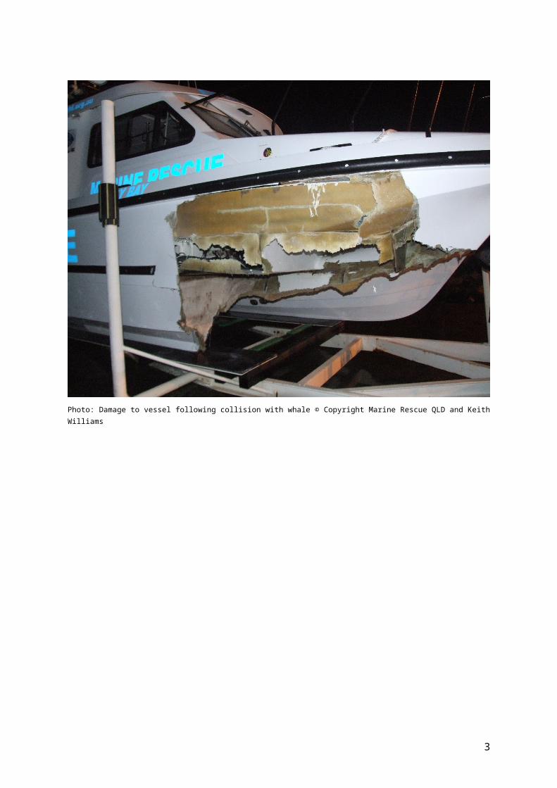
Photo: Damage to vessel following collision with whale © Copyright Marine Rescue QLD and Keith Williams
2

Strategic Framework Flowchart
STRATEGIC FRAMEWORK FOR MINIMISING THE RISK OF VESSEL STRIKE
Objectives and actions
Objective 1: Data acquisition – addressing information and knowledge gaps.
One of the main difficulties in approaching the issue of vessel strike is that available data is often patchy and does not necessarily reflect the actual distribution or occurrence of vessel strike incidents. The collection, collation and interpretation of data are the first critical steps in this process. This involves identifying species at risk; the spatial and temporal characteristics that make these species susceptible to vessel strike; species behaviour and interaction with vessels; vessel characteristics, including vessel type, patterns, densities and movements, and the impacts and injuries to mega-fauna that have been involved in a vessel collision.
At a minimum, information collected on vessels and marine mega-fauna needs to be adequate to understand the relative risk of mega-fauna vessel collision across Australia. To quantify relative risk, data on vessel and mega-fauna densities is required to identify where the co-occurrence of mega-fauna and vessels occur. Information might be collected from existing sources, modelling and projections. Following the identification of areas of higher relative risk, further targeted research may be required. Finer scale information including species habitat use and vessel characteristics and movements can be collected at local and regional scales, where there is existing information to suggest vessel strike may be a problem.
3
Key actions
- For large vessels (those mandated to be fitted with Automatic Identification System (AIS) Class A), identify areas of high use in Commonwealth and state/Territory waters. Examples may include international shipping lanes and ferry routes.
- For all other vessels not fitted with AIS Class A, such as recreational vessels and high speed sports vessels, identify areas of high use in near shore locations and confined bays.
- Where information is available, identify areas of projected growth in shipping and recreational vessel use in existing and emerging locations.
- Identify species suitable for a risk assessment based on known distribution, conservation status, vulnerability to vessel strike and feasibility.
- For areas identified as having high vessel use, define the distribution and abundance of suitable species in.
- Collect information on vessel strike using historical records, government records (including state databases such as the NSW Marine Fauna Event Database and QLDs StrandNet) and the National Ship Strike Database https://data.marinemammals.gov.au/report/shipstrike
- Undertake and document necropsies on stranded mega-fauna where evidence suggests vessel strike as the likely cause of death and where modelling can reasonably determine the location of the collision.
- Undertake and document necropsies on stranded fauna to determine if vessel collision was the likely cause of death.
- Better understand mega-fauna and vessel characteristics and behaviours, human behaviours and environmental factors that increase collision risk including:
o species habitat use such as for breeding, feeding, migrating and resting
o species behaviour such as speed and manoeuvrability, time spent at the surface, use of channels
o species awareness of risks posed by vessels
o vessel characteristics including shape, speed, manoeuvrability, predictability
o human behaviour and its influences collision risk
o level of, and effectiveness of enforcement
o season
o impact of noise on ability of mega-fauna to hear or detect the direction of approaching vessels
o water depths.
- Where outcomes of data assessment identify areas of high vessel strike risk, undertake targeted research to understand the nature of the interactions, which will in turn determine which mitigation and management measures are appropriate for locations, times and species.
4

Outcomes
- Maps and data of high use areas for vessels fitted with AIS Class A, including level of use, vessel type and speeds.
- Maps and data of near shore locations indicating level of use and vessel types.
- Maps and data describing reported vessel strikes.
- List of species rated according to their suitability for analysis.
- Maps of key species distribution, density and habitat use in areas of greater vessel density as shown by the case study provided below.
- Characteristics of the marine environment that are likely to contribute to the increased risk of vessel collision e.g. channels at low tide or location of seagrass beds.
- Data and data layers open access and easily available on a publicly accessible website.
CASE STUDY – Data Acquisition
Distribution patterns of Blue Whale (Balaenoptera musculus) and shipping off southern Sri Lanka (Priyadarshana et al. 2015)
Visual and acoustic surveys were undertaken off the southern coast of Sri Lanka to better understand blue whale distribution in relation to existing shipping lanes, with the data being used to model patterns of whale density. A high density of whales utilising this extremely busy shipping route suggests a severe risk of vessel collision.
Figure 1 shipping density according to scale measured as km-1 year-1. Red circles indicate all blue whale sightings from surveys and whale watch observations by Raja and the Whales. Red shaded area indicates possible alternative shipping route 15 nm to the south of the current Traffic Separation Scheme. Source: Priyadarshana et al. 2015.
5

Objective 2: Data analysis - determine risk of vessel strike
The primary aim of this objective is to use the data compiled under Objective 1 to determine the risk of mega-fauna colliding with vessels. This data can be used to determine the relative risk of vessel strike for species at the local, regional and national scale. This will allow the identification of potential areas of concern that require further detailed assessment and/or data collection. Relative risk can also be used to assess the change in risk due to possible future changes in shipping patterns/distribution. The outcomes of this risk assessment will also feed back into the previous objective concerning identifying information that is required to undertake a more detailed risk assessment at smaller scales.
Key Actions
- Develop methods to determine the relative risk of vessel strike for different species at an appropriate scale (local, regional or national).
- Undertake a national risk analysis for a range of marine taxa identified as suitable for analysis in the previous objective.
- Identify locations where there is a higher relative risk of mega-fauna vessel strike (‘hot spots’), as indicated in the case study provided below.
- Understand the nature of the interactions for areas identified as ‘hot spots’.
- Promote the use of risk assessments in planning facilities and activities in the marine environment to stakeholders, such as government agencies, tourism operators and port authorities.
- Provide outcome of risk assessments and analysis of further data required.
Outcomes
- Relative risk maps at an appropriate scale for key species.
- Stakeholders using appropriate risk assessments where a need is identified.
- Outcomes and risk maps are open access and easily available on a publicly accessible website.
6
CASE STUDY- Data Analysis
Quantitative assessment of the relative risk of ship strike to humpback whales in the Great Barrier reef (Peel et al. 2015) – On the east coast of Australia the main breeding ground for humpback whales is within the Great Barrier Reef World Heritage Area (GBRWHA). Both the east and west coast of Australia have also in the past decade experienced considerable coastal and port development and as a consequence an increase in shipping activity. Considering the rapid rate of increase of the east Australian population of humpback whales there is potential for increased interaction between humpback whales and shipping traffic and increased risk of ship strikes to the whales on their breeding ground.
To understand the risk of ship strike to humpbacks in the GBRWHA, it is necessary to understand the distribution and densities for both whales and shipping. This study used current knowledge on the distribution of humpback whales within the GBRWHA and contemporary shipping traffic data to provide estimates of relative risk of ship strike to humpback whales within the GBR.
The analysis shows that the areas of highest relative risk coincide with offshore areas around the two major ports on the Queensland coast spanning the offshore area between the Whitsundays to south of Mackay near Shoalwater Bay. One limitation of this risk assessment is that there are no results for the offshore areas to the south of Gladstone due to a lack of whale survey data in deeper waters. The full report can be found at:https://data.marinemammals.gov.au/common/documents/grants/2013/AMMC-15-FINAL_REPORT-Quantitative_assessment_of_the_relative_risk_of_ship_strike_to_humpback_whales_in_the%20GBR-v1.2.pdf
Figure 2 Co-occurrence risk for all whale groups and for all vessel type over the Southern extent of the GBR. Source: Peel et al., 2015.
7

Objective 3: Mitigation - reduce the likelihood and severity of mega-fauna vessel collision.
It is not always clear which mitigation measures are effective and where, how, and under what circumstances a measure for a particular location or species may be best employed. Consideration must be given to the time of year, species conservation status and behaviour, vessel characteristics and movement patterns, and the level of education and enforcement required to change human behaviour.
Data acquisition and analysis would generally precede the implementation of mitigation measures and should help to inform the development of mitigation measures.
Mitigation measures may take the form of guidance, where particular measures are encouraged to reduce impacts, or regulated such as permanent routing measures, speed restrictions and exclusion zones. The degree to which regulation is used will depend on the level of risk posed to a species and/or its conservation status. The use of regulation is most appropriate for threatened species that are at a higher risk of vessel collision. In the case of large cetaceans, measures can fall into three main categories - keeping vessels away from whales, slowing vessel speeds and avoidance manoeuvres.
It’s also important to note that the implementation of mitigation measures must not compromise navigational safety at sea.
Key actions:
- Identify best practice mitigation measures and emerging technologies.- Develop and improve mitigation measures.- Encourage innovation and collaboration between research organisations and industry.- Develop a mitigation measures toolkit that provides guidance to stakeholders and managers on
what measures are most suited to specific locations, species and vessel types.- Encourage the development and implementation of vessel strike management plans in locations
where the relative risk of vessel strike is high, as determined by a risk assessment, as shown by the case study below.
- Encourage the use of monitoring programs to measure the success of mitigation measures implemented and identify potential improvements.
- Evaluate and review mitigation measures on a regular basis.
Outcomes
- A mitigation measures toolkit accompanied by a set of criteria that provides guidance on measures to be used.
- New and innovative measures have been developed. - Where higher risk areas are identified, appropriate mitigation measures are considered and
applied.- The effectiveness of mitigation measures in reducing vessel collision is understood and reflected
in the mitigation measures toolkit. - The risk of vessel strike on marine mega-fauna in Australian waters is reduced.- Adaptive management of vessel strike.
8

CASE STUDY – Mitigation
Offshore example: The case of the endangered North Atlantic Right Whale - This species migrates along the east coast of the US and has been reduced to less than 500 individuals in the world. Collision with vessels is the leading human-caused source of mortality for the endangered North Atlantic right whale. To reduce ship strike the US government introduced seasonal speed restrictions (10 knots or less), areas to be avoided, recommended shipping routes and traffic separation schemes for certain areas of the US east coast. Further information can be found at http://www.nmfs.noaa.gov/pr/shipstrike/
Figure 3 Mid-Atlantic Seasonal Management Area (Source: NOAA)
Near shore example: Moreton Bay in Queensland – Moreton Bay is home to dugong, six species of marine turtle, dolphins as well as providing seasonal habitat for migrating whale. To protect dugong and turtles from boat strike the Queensland government has implemented go slow areas for certain areas of Moreton Bay http://www.nprsr.qld.gov.au/parks/moreton-bay/zoning/pdf/marine-park-user-guide.pdf . This includes:
- Go slow areas for turtles and dugong:
o All vessels must travel off-plane or in displacement mode, and in a way that minimises the chance of a turtle or dugong being struck.
o Motorised water sports are prohibited.
- Go slow areas for turtles and dugong (vessels >8m):
o Vessels >8m are restricted to 10 knots or less.
High speed vessel events in marine parks (Queensland): This operational policy outlines the circumstances under which a high speed vessel events may be permitted to occur within state marine parks http://www.nprsr.qld.gov.au/policies/pdf/op-pk-mp-high-speed-vessel-events.pdf
9

Objective 4: Communication - undertake clear and effective communication through all stages of the strategy.
Communication is a vital component of any strategy and is important for all stages, from collecting information on species and vessels, through to the development, implementation and evaluation of management measures to reduce vessel strike. Communication should occur between all stakeholders, including government agencies, scientists, industry, non-government organisations (NGOs), vessel owners and operators, and members of the general public.
Key actions:
- Identify key stakeholders and other groups with an interest in the Strategy including government, researchers, NGO’s, industry and the public.
- Seek input and cooperation from key stakeholders to collect data, undertake analysis and develop and implement mitigation, including:
o Seeking input from individuals and agencies that hold relevant data and information that can be used in undertaking risk assessments.
o Communicating results of national risk assessment to key stakeholders.o Implementing mitigation measures.
- Promote the Strategy, including:
o Promote the use of the National Vessel Strike Database in Commonwealth waters and encourage the states/Territory to support and promote its use in waters within their jurisdictions https://data.marinemammals.gov.au/report/shipstrike .
o Promote the use of risk assessment methodology where more detailed local research is required.
o Promote the application of management measures where risk assessment indicates a need, including the use of monitoring.
o Education and outreach programs. - Develop a communication plan.
Outcomes:
- Increased reporting of vessel collision.
- Stakeholders understand risks and how to reduce them.
- Mitigation measures are implemented.
- Stakeholders have had the opportunity to provide input.
- Stakeholders are aware of relevant vessel strike mitigation resources and are using them in decision making processes.
10

Marine Notice 15/2016 Minimising the risk of collisions with cetaceans:
Marine notices are published by the Australian Maritime Safety Authority and provide information to the shipping and broader maritime community on a range of issues.
The purpose of this Marine Notice is to provide guidance to shipowners and operators in reducing the risk of collision with cetaceans. It also provides information on the location and migration periods of threatened whale species that occur in Australian waters.
More information can be found at: https://apps.amsa.gov.au/MOReview/MarineNoticeExternal.html
Duration, cost and evaluation
Ongoing and effective monitoring and evaluation of the Strategy is critical to ensure that it continues to support best practice and that the actions are helping to achieve the Strategy goal of reducing vessel strike risk. The Strategy should be reviewed at intervals of no longer than 10 years.
Investment in many of the actions listed in the Strategy will be determined by the level of resources that government and stakeholders commit to manage the problem. As knowledge regarding the full extent of the problem in Australian waters is not known, the total cost of implementation cannot be quantified.
Projects currently funded or underway
- Quantification of risk from shipping to large marine fauna across Australia. Project summary - Tools and research are needed to spatially quantify the risk of ship strike to help develop management strategies. This work will use shipping density/speed data from the recent past, in parallel with species distribution/habitat models, to produce relative risk maps that can be used to identify areas and times where there is co-occurrence of at-risk marine fauna and shipping. http://www.nespmarine.edu.au/project/project-c5-quantification-national-ship-strike-risk
- Ship strike database – the Australian Government has developed a national ship strike database and associated web-based questionnaire. The data collected will inform other actions under this strategy and is compatible with the International Whaling Commission (IWC) ship strike database. https://data.marinemammals.gov.au/report/shipstrike
Strategy evaluation should identify knowledge gaps; evaluate the success of methods used to collect information and determining risk, the success of management measures and the effectiveness of communication.
11

BACKGROUND
Data and Trends
International
IWC data indicate that there has been an increase in reported cetacean vessel collisions over the last 50 years (IWC 2010) (Figure 4). This increase is likely to be a combined result of several factors including better reporting, increased conservation interest, increased vessel activity and increasing population size for some species.
Although the number of reported incidents globally per year remains relatively low, there continues to be a significant number of incidents that are not reported to the IWC. This lack of reporting is likely a result of ship personnel being inexperienced with reporting procedures, fear of penalties if incidents are reported and species interactions going undetected due to large vessel size or vessel speed (Laist et al. 2001). In the case of stranded fauna, vessel collision may not always be recognized as the cause of death due to absent or inconclusive post mortems. Early data is based on historic accounts rather than direct reports.
Figure 4 Number of vessel-strike incidents reported for the years 1903 to 2009 from the IWC global database (Data source: IWC 2010)
1903
1904
1905
1908
1910
1913
1926
1930
1935
1940
1943
1950
1952
1953
1954
1955
1958
1960
1961
1963
1965
1967
1970
1971
1972
1973
1974
1975
1976
1977
1979
1980
1981
1982
1983
1984
1985
1986
1987
1988
1989
1990
1991
1992
1993
1994
1995
1996
1997
1998
1999
2000
2001
2002
2003
2004
2005
2006
2007
2008
2009
05
10152025303540
Num
ber o
f shi
p st
rikes
International data on ship strikes collated in the IWC global database shows the vessel type in the vast majority of strikes has not been recorded or is listed as ‘unknown’ (Figure 5). From the records with listed vessels, whale-watching boats, naval ships and container ships were recorded in the higher number of collisions. Laist et al. (2001) notes that it is likely that greater passengers and crew awareness is reflected in the higher numbers of whale watching and naval vessels involved in collisions.
Australian waters
A recent paper by Peel et al. (2016) provides the most up to date analysis of whale vessel collisions in Australian waters. Following a detailed search of online archives the study found reports dating back to 1840, including 74 additional records not in the IWC database, bringing the number of reported vessel collisions in Australian waters to 109. While this increases Australia’s contribution to worldwide reports, the paper also notes that international vessel strike data will be influenced by reporting bias and unknown coverage, and as such Australian vessel strike numbers may not reflect Australia’s actual international contribution.
12

Figure 5 Proportion of vessel type involved in collisions with cetaceans in (a) international waters and (b) Australian waters (Data source: IWC 2010, Peel at al 2016)
SailRacing YachtSmallPassengerNavyTugFishingCargoTankerWhale-W
(a) (b)
Response to Vessel Collision
The IWC has been a key player in investigating the issue of ship strike through its Conservation and Scientific Committees. To gain further insight into this global problem and potential measures of mitigation a ‘Ship Strike Working Group’ (SSWG) was established in 2005, of which Australia is an active member. Focus was directed at improving ways to estimate the number of whales involved in vessel strike. In February 2016, the IWC submitted a paper summarising their work on ship strikes to the Maritime Environment Protection Committee of the International Maritime Organisation (IMO) (IWC 2016).
A global database incorporating information about cetaceans and vessels involved in collisions provides estimates of the incidence of ship strike, identifies trends and allow better understanding of risk factors. Currently there are over 300 international records of vessel collision dating back to 1982 (IWC 2010).
The International Maritime Organization (IMO) is the United Nations specialised agency that has responsibility for establishing standards for the safety, security and environmental performance of international shipping. The IMO has taken action to reduce the threat of ship strikes to large whales since first considering this issue in 1997. Since 1997, and based on submissions to the IMO, a range of IMO-adopted measures have been implemented by various countries where there are known ship strike impacts due to the overlap of high shipping traffic and whale occurrence. Measures can include ship reporting systems and voluntary or mandatory ship routeing systems, including traffic separation schemes and Areas to be Avoided, to reduce ship/whale interactions.
In 2009, the IMO’s Marine Environment Protection Committee (MEPC) approved a guidance document for minimising the risk of ship strikes to cetaceans and issued this document as an MEPC circular for the attention of interested parties and shipping companies. This document, while emphasising that maritime safety is paramount, sets forth important general principles and actions that may be taken to reduce the risk of ship strikes. These principles include the scientific assessment of shipping activity and co-occurring cetacean populations, evidence-based risk mitigation, monitoring the effectiveness of any mitigation measure, and seafarer education and outreach programs. Australian policy and principles has been informed by the guidance document endorsed by the IMO MEPC in 2009.
13
123456789

The Secretariat of the Pacific Regional Environment Programme (SPREP) is an intergovernmental agency represented predominantly by Pacific Island countries including Australia. The SPREP Marine Species Programme is a regional strategy for the conservation and management of dugongs, marine turtles, whales and dolphins (SPREP 2016). Vessel interaction is identified as a threat for all species in the program and specific actions to reduce vessel interaction are proposed in the Whale and Dolphin Action Plan 2013-2017(CMS 2015).
Legal framework
National Legislation
The Environment Protection and Biodiversity Conservation Act 1999 (EPBC) Act is the Australian Government’s key piece of environmental legislation. Under the Act approval is required for any proposed action, including projects, developments, activities, or alteration of these things, likely to have a significant impact on any of the identified matters of national environmental significance. Two of the matters protected by the Act are threatened species and migratory species. In the Commonwealth marine areas it is also an offence to kill or injure a member of a species listed threatened, migratory, marine or cetacean.
Under the EPBC Act, listed threatened species are required to have Conservation Advice or Recovery Plans. There are currently Conservation Management Plans (Recovery plans under the EPBC act) for the southern right whale and blue whale. Both of these Plans identify ‘minimising vessel collision’ as being high priority actions. Minimising vessel collision is also identified as a high priority action in the Conservation Advice for fin, sei and humpback whales.
In addition to the cetaceans mentioned above, the Recovery Plan for Marine Turtles in Australia (2003) identifies boat strike as being an issue in Queensland waters, with reference to Moreton Bay and Hervey Bay as being the principal areas of concern. Recovery actions in the Plan include identifying areas of high boat strike and determining the feasibility zoning boat speed restrictions in Queensland.
State and Territory Legislation
Coastal waters (up to 3 nm offshore) lie under state and Territory jurisdiction. Marine species present in this area are protected under legislation relevant to the adjacent state or Northern Territory. State and territory legislation relevant to the protection of marine fauna includes:
- Threatened Species Conservation Act 1995 (NSW).
- Wildlife Conservation Act 1950 (WA).
- Nature Conservation (Wildlife Management) Regulation 2006 (Qld).
- National Parks and Wildlife Act 1972 (SA).
- Threatened Species Protection Act 1995 (Tas).
- Whales Protection Act 1988 (Tas).
- Nature Conservation Act 2002 (Tas).
- Wildlife Act 1975 (Vic).
- Territory Parks and Wildlife Act 2000 (NT).
14

Photo: Recreational boat passing dugong mother and calf in Moreton Bay © Copyright Rachel Groom
What makes a species vulnerable to vessel collision?
Cetaceans
While factors such as vessel speed are known to affect the incidence and severity of a collision, understanding whale behaviour in the presence of vessels is less understood (McKenna et al. 2015). There are however a number of behaviours that make certain species more vulnerable to vessel strike, including swimming behaviour such as speed, distraction by other activities, failure to hear vessels and the habituation and general lack of awareness of vessel noise and danger posed by vessels.
Some species spend more time at the surface when resting, foraging or mating making them more vulnerable during these behaviours. Species that are known to spend more time at the surface include sperm whale, which have been observed sleeping at or just below the surface (Miller et al. 2008). Juvenile and unwell individuals may also spend more time at the surface (Koschinski 2003).
Laist et al. (2001) noted that individuals engaged in behaviours such feeding, mating or nursing may be more vulnerable to vessel collision, when distracted by these activities.
A study by McKenna et al. (2015) showed that blue whales demonstrated limited behavioural response when being approached by ships. While some individuals responded by undertaking shallow dives at a slow descent, none showed signs of horizontal movement away from the approaching ship.
Dugong
Studies in Queensland showed that dugongs spend around 47% of their time within 1.5 m of the surface including 3.5% resting at the surface (Hodgson 2004). This study also showed that calves spent 13% of their time travelling or resting on their mothers’ back.
There is evidence that dugongs fail to flee or evade the approach of fast approaching vessels until an impact is unavoidable (Groom et al. 2004). Hodgson (2004) believes that vessel speed is the primary factor affecting collision risk due to ‘the time available to flee being equal to the time the boat takes to travel the distance from the flee threshold to the dugong’. In shallow water with large intertidal areas, vessels and dugongs can be constrained to channels during low tide periods, increasing the probability of vessel interaction. Groom et al. (2004) also recorded dugongs responding to an approaching vessel by moving towards deeper water, which again may result in dugongs interacting with vessels in channels.
Marine Turtle
The effect of vessel speed and turtle flee response can be significant. A study by Hazel (2007) recorded 60% of green turtles (benthic and non-benthic) fleeing from vessels travelling at 4km h, while only 4% fled from vessels travelling 19 km h. When fleeing 75 % of turtles moved away from the vessel’s track, 8% swam along the vessel track and 18% crossed in front of the vessel. The study concluded that most turtles would be unlikely to avoid vessels travelling at greater then 4 km h.
15

The propagation characteristics of sound in the marine environment make it difficult for marine turtles to identify the direction of the source of vessel noise, and areas of high vessel use (and other anthropogenic noise) may mask individual noise (Hazel et al. 2009). This is likely to limit the ability of marine turtle to use sound to avoid approaching vessels.
The relatively small size of turtles and the significant time spent below the surface makes their observation by vessel operators extremely difficult or impossible. Green turtles observed by Hazel et al. (2009) generally only exposed the dorsal-anterior part of the head above the surface of the water and never for longer than 2 seconds.
Whale Shark
Whale sharks are known to spend considerable time close to the surface increasing their vulnerability to vessel strike. Whale shark tagged off Western Australia (Wilson et al. 2006, Gleiss et al. 2013) spent approximately 25% of their time less than 2 metres from the surface and greater than 40% of their time in the upper 15m of the water columns.
Whale sharks migrate large distances and can be found in coastal offshore waters. Spending such considerable time within the 15 m of the surface leaves them vulnerable to collision with smaller vessels as well has larger commercial vessels that have drafts that extend greater than 20 m below the surface.
Impacts of Vessel strikes
The consequence for a marine animal involved in a collision with a vessel can range from minor to extreme. An individual may show no sign of injury, have a survivable non-debilitating injury or it could be debilitating or even fatal. Vessel strike may include collisions with the bow or hull which can cause major cranial fractures, haemorrhaging, tissue and organ damage, bow draping (often only of large cetaceans) whereby a large animal becomes draped over the bow and dragged along at the front of the vessel over substantial distances, or being struck by the propellers, potentially causing loss of fins or flukes and severe lacerations to the body (van Waerebeek et al. 2006).
Whilst a major risk, these injuries are not always lethal. Jensen and Silber (2003) reported that in 292 incidents of vessel strike with large cetaceans, only seven individuals appeared to have no signs of injury, while Jefferson (2000) identified several dolphins with evidence of severe propeller injuries on the back of the animal and the dorsal fin. In
16
Photo: Mother and calf dugongs killed by boat strike © Rachel Groom

these cases, the loss of blood, possibility of infection and reduced swimming efficiency
would lead to an overall reduction in fitness of the individuals (van Waerebeek et al., 2006).
Impacts to an individual animal can have welfare implications as a result of suffering, reduced fitness and loss of life, or depending on the status of the species the impacts can be at a level. Defining a population will vary with species and management authorities. The EPBC Act defines a population of a species as an occurrence of a species in a particular area. In the case of whales and marine turtles, populations are defined genetically.
In the case of a species that is recovering, such as the east and west coast populations of humpback whales the loss of one individual would be unlikely to impact on either population. However, in the case of south-eastern Australian population of the southern right whale which is showing little evidence of recovery, the loss of a female individual would be considered significant.
The influence of vessel speed on the incidence and severity of collision
Speed is a concern when considering collision risk and the outcome. Vanderlaan and Taggart (2007) observed that an escalation in speed of the vessel caused an increase in the severity of injury to large cetaceans. Slower moving vessels provide greater opportunity for both fauna and vessel to avoid collision. Species detection depends on their profile on the surface and slower moving vessels would be afforded greater time to manoeuvre and predict their movements. Vessel speed may also result in
17
Photo: Impacts of vessel collision on whale © NPWS and Scott Filmer

animals, including large whales, being drawn laterally towards the hull of the vessel (Silber et al. 2010).
18

Collisions with large cetaceans involve a variety of vessel types including large ships such as tankers, cargo or cruise ships, but also navy ships, whale-watching vessels, yachts or hydrofoils (Laist et al ., 2001; Jensen and Silber 2003; van Waerebeek et al., 2007; Carrillo and Ritter 2010). Large, high-speed vessels, in particular, have become a major concern as they are capable of travelling at speeds of up to 35 to 40 knots, which correlates to an increase in collisions (Weinrich 2004; Ritter 2007). Many of these vessels also incorporate modern hull shapes which may be particularly hazardous to cetaceans (Carrillo and Ritter 2010). According to Laist et al., (2001), 89% of incidences where the whale was severely hurt or killed occurred at vessel travelling speeds greater than 14 knots and were most serious in large vessels (> 80 m). Furthermore, the chance of an injury being lethal increases significantly, as vessel speed increases up to 15 knots (Vanderlaan and Taggart 2007).
Similarly, Hazel et al., (2007) and Hodgson (2004) found speed to be a critical factor in determining a flee response in marine turtles and dugongs being approached by vessels. The proportion of flee responses decreased significantly with increasing speed, particularly with close encounters. While speed is a particularly important factor, so is the type of behaviour the vessel is displaying, i.e. whether a vessel is transiting a dedicated route or is a recreational boat that is moving erratically.
Vessel Movements and Densities in Australian Waters
Commercial vessels
Australia is geographically remote from major world suppliers and markets and therefore relies heavily on sea-borne trade. Over 98% of Australia’s trade by weight is carried by sea (BITRE 2014). Figure 6 shows the location of major Australian ports and the level of shipping activity associated with each of these ports.
Figure 6 National ports showing total number of commercial vessel calls for 2013/2014 (Note: Sydney includes Sydney Harbour and Port Botany) (Data source Ports Australia 2014)
19

Over 30 000 commercial vessels visited Australian ports for the year ending 2014. This included 11 000 dry bulk vessels, 5308 container vessels, 3225 bulk liquid vessels and 737 cruise vessels (Ports Australia 2014, Port of Melbourne 2016).
A report by BITRE (2014) forecasts containerised trade (20 foot equivalent units (TEU)) across Australian ports to increase by 5.1% per year until 2032, while non-containerised trade (tonnes) is forecast to increase by 3.9% per year. The report also forecasts sea passengers (inbound and outbound) to increase by 1.8 % per year over the same period. While factors such as increased vessel sizes may influence forecast vessel numbers, this level of increase in tonnage/units/passengers is likely to result in a significant increase in shipping activity in Australian waters in the future.
Recreational vessels
Prideaux (2012) undertook a review of relevant literature and found that there was approximately 832, 065 recreational boats registered in Australia. Table 1 provides the approximate number of registered recreational boats for each state and Territory. The review indicates that Queensland has the highest ownership of registered recreational vessels in Australia.
Table 1 Number of registered recreational boats in Australia (Data source: Prideaux 2012)
Approximate number of registered recreational boats (< 24m)
Approximate number of recreational ships (> 24m)
Approximate total
Queensland 233,600 1,727 235,327
New South Wales 228,643 1,862 230,505
Victoria 172,847 707 173,554
Western Australia 93,244 642 93,886
South Australia 51,844 284 52,128
Tasmania 29,370 287 29,657
Northern Territory 11,717 296 12,013
Australian Capital Territory 10,800 N/A 10,800
Australia wide 832,065 5,805 837,870
N.B. Actual number of boats may be higher as this statistic does not include non-powered boats. Findings should be interpreted with caution as not all boats require registration and therefore, the total number of boats may be much higher.
20

Recreational vessels trends in Queensland
In January 2016 there were approximately 256,000 registered recreational vessels in Queensland, with the highest number of registrations being in the Brisbane maritime region with 143,000 and the Gladstone maritime region (includes the coastal area from the Capricorn Coast to Hervey Bay) with 48,000. Over the last eight years the number of registered recreational vessels in Queensland has increased by approximately 16%. Over this period the Gladstone maritime region region had the highest percentage increase of approximately 23% (Maritime Safety Queensland 2016).
Figure 7 Growth of registered recreational vessels in Queensland between 1996 and 2014.
19961997
19981999
20002001
20022003
20042005
20062007
20082009
20102011
20122013
20140
50,000
100,000
150,000
200,000
250,000
300,000
Number of Registered Recreational Vessels in QLD 1996-2014
Data source: Maritime Safety Queensland 2016.
Australia’s population has grown by approximately 1.3% per year between 1992 and 2012 and is forecast to grow at approximately 1.5% per year until 2032. This is considered high by OECD average growth rates that have ranged from 0.5% and 0.7% per year over the same period (Commonwealth of Australia 2015).
A report by NSW Maritime (2010) states that boat ownership in New South Wales has generally mirrored population growth and that there has been little evidence of the effects of economic crises on Australian boat ownership. While there are likely to be other factors that influence vessel numbers, considering Australia’s high population growth it is considered likely that there will also be significant growth in the number of recreational vessels in Australia.
Passenger ferry services
Passenger ferry services within or close to large population areas can contribute to high vessel traffic. Significant ferry traffic occurs in Sydney Harbour in addition to the commercial and recreational vessels, water taxis, naval vessels and sea-going ships. Regular passenger and car ferries travel between mainland Australia and offshore islands such as Rottnest Island in Western Australia, Kangaroo Island in South Australia and Stradbroke Island in Queensland. Stradbroke Island Ferries alone make up to 25,000 crossings of Moreton Bay each year (http://www.stradbrokeferries.com.au/about/ ).
21

Species of Concern in Australian waters
Whales
Data on vessel strikes of large cetaceans in Australian waters to date are limited. What is known has been compiled from reports given to the IWC global database (IWC 2010) and a more recent report by Peel et al. (2016).
In Australian waters, records of vessel strike from 1997 to 2015 show that humpback whales, in particular, occur with the highest frequency (47%) followed by southern right whales with 12%. 25% of the records were recorded as unidentified large whale (Peel et al. 2016). Figure 8 shows the approximate locations of reported vessel collisions for whales in Australian waters between 1990 and 2015, and the locations of whales that were found at sea or washed up, where the cause of death was attributed to vessel strike. Figure 9 provides a breakdown of large cetaceans involved in vessel strikes in Australian waters in modern times.
Figure 8 Location of reported vessel collisions with whales, or other incidents such as strandings where cause of death is attributed to vessel collision. (Data source: Peel et al. 2016, Commonwealth of Australia (2014) ESRI Australia Pty Ltd (1992): ARCWORLD World Dataset 1:3 million, Geoscience Australia (2004): GEODATA TOPO 100K – Coastline, Geoscience Australia (2006): GEODATA TOPO 250K).
Documented vessel strikes in Australian waters listed in the global IWC database date back to 1988, but are sparse until after the year 2000. Peel et al. (2016) undertook a preliminary examination of vessel collision reports between 1840 and 2015. While the 2010 IWC ship strike database contained 35 records in Australian waters, the paper found additional records that increased the total to 109 records. It was also noted that further validation is needed for the additional reports.
22

Figure 9 Break down of large cetaceans involved in vessel strike in Australian waters from 1997 to 2015 (Data source: Peel et al. 2016)
Break down in large cetaceans involved in vessel strikes
Humpback whaleUnidentifiedSouthern right whaleSperm whalePygmy blue whaleBlue whalePygmy sperm whaleDwarf minke whalePygmy right whaleFin whaleAntarctic minke whale
Southern Right Whale (Eubalaena australis)
The southern right whale is currently listed as endangered under the Environment Protection and Biodiversity Conservation Act 1999. In Australian waters there is a south-west population and a south-east population.
Southern right whales generally migrate as far north as Sydney on the east coast and occasionally as far north as Hervey Bay. In coastal waters southern right whales generally occur within two kilometres off shore.
Southern right whales from the south-west population appear to be increasing at the maximum biological rate but there is limited evidence of increase in south-eastern waters. The most recent population estimates for the south-east population range from 224 – 257 and numbers of breeding females could be as low as 45.
Southern right whales are considered vulnerable to vessel strike due to their presence in near shore waters during critical life phases such as breeding, slow swimming behaviour and spending a lot of time on the surface.
Due to their extremely low population estimates, the loss of an individual from the south-east population would be considered an adverse impact to this population while the impact of losing one breeding female would be extremely adverse. Small populations are also more vulnerable to inbreeding and the impacts of stochastic events.
In recent times there have been at least three fatal vessel collisions and two non-fatal vessel collisions in Australian waters. In 2001 a ferry traveling between the mainland and Kangaroo Island struck and killed an adult southern right whale. In 2014 a sub adult female was hit and killed by a ferry while travelling between Cleveland and North Stradbroke Island, Queensland.
23

The major problem with records of collisions to date is the vast knowledge gaps, especially concerning true numbers of vessel interactions with different species. Even though there is the obligation to report any vessel collisions that may result in a cetacean being injured or killed (Section 232, EPBC Act), it’s likely that some vessel collisions go undetected and/or are not being reported (Laist et al. 2001).
The steady increase over the last decade in shipping activity in Australia and the predicted escalation in the future (Laist et al., 2001, BITRE 2014), coinciding with the growth in population size of both southern right whale (south west population) and humpback whale populations, suggests the probability of vessel interactions involving these species will also increase.
Dolphins, Dugong, Whale Shark and Turtle
As smaller taxa and vessels are often confined to significant intertidal areas or constrained to narrow channels during low tidal phases, there is a considerable increase in the risk of vessel strike. In coastal areas of Australia, inshore populations of dolphins, marine turtles and dugongs inhabit or migrate through some of the nation’s busiest waterways. The resulting interaction between inshore species and bathymetry is likely to be a major factor in the higher probability of vessel strikes in such areas. Small motorised, fast moving vessels have increased as a source of anthropogenic disturbance, be it noise or collision, in coastal waters due to their rise in popularity.
Whale sharks routinely feed at the surface making them vulnerable to vessel strike. This species is found in coastal and oceanic environments making them vulnerable to both collisions with smaller recreational vessels and large ships.
The IWC database has limited records of vessel strike with dolphins in Australian waters. Between 1988 and 2000 there were only three documented incidents involving small marine mammals, including a single Indo-Pacific Humpback Dolphin, a Common Bottlenose Dolphin and an unidentified dolphin.
In New South Wales, the National Parks and Wildlife Service (NPWS) maintain a Marine Fauna Event Database which records all marine fauna strandings. Within this database, there have been six recorded incidents of vessel strike involving Bottlenose and Common Dolphin species to date. Two of these incidents involved a Common Dolphin and occurred in Sydney harbour, four resulted in fatalities (NPWS 2013).
In Tasmania, the Marine Conservation Program within the Department of Primary Industries, Parks, Water and Environment (DPIPWE) maintains a database of cetacean sightings, strandings, entanglements and/or other injuries. Since 1999, ten incidents of vessel-strike have been reported and recorded, involving six species. Six events resulted in confirmed fatalities.
The Queensland Department of Environment and Heritage Protection (EHP) maintain a database of marine wildlife strandings and deaths (referred to as StrandNet). In 2011, StrandNet recorded 126 incidents involving marine turtle interactions with vessels, including propeller cuts and impact injuries from colliding with the hull. Of these occurrences, 116 were fatalities, making this interaction the greatest cause of anthropogenic mortality to marine turtles in this year. The vast majority of these records involved green turtles, with flatback, loggerhead and hawksbill species also involved in incidents of vessel strike. Of these records, it is also notable that an overwhelming number occurred in Moreton Bay, Gladstone and Townsville areas with 51, 36 and 13 respective records. Collectively between 1996 and 2011 there were 48 recorded stranding events of dugongs, with evidence of boat strike in Queensland (DEHP 2011).
24

Potential Areas of Concern for Large Cetaceans
Given the migratory nature of many large cetaceans, defined ‘areas of concern’ may only be relevant on a temporal or seasonal basis when whale movement through a region is high. Areas surrounding major Australian ports, primarily along the east and west coasts where shipping activity is highest may be cause for concern. Melbourne, Brisbane, Newcastle, Dampier, Sydney, Port Hedland, Fremantle, Darwin and Gladstone harbours or ports had the highest number of ship calls (during the 2013/14 period) and all, with the exception of Darwin, lie on migratory routes and/or close to areas that whales aggregate.
Figure 12 illustrates the migratory routes and aggregation areas for humpback whales along the west and eastern seaboard and the relevant shipping density data. It is evident that there is an overlap between humpback whale migratory paths and shipping activity, in particular the high number of port calls in known regions of cetacean distribution (e.g. Brisbane Harbour and Dampier Port). Figures 13 and 14 overlay blue whale and southern right whale core habitat and aggregation areas with AIS shipping point density data and provides a basic representation of where ships are likely to co-occur with these species.
Peel et al. (2016) looked at the spatial and temporal distribution of vessel collision reports in modern times and showed that the majority of records were from Queensland (Figure 11). The seasonal distribution of vessel strikes in all Australian waters showed that the majority of vessel collisions for humpback whales and southern right whales occurred in the month of August (Figure 10).
Figure 10 Seasonal distribution of reported vessel collision for humpback whales, southern right whale, sperm whale and all whales in Australian waters (Data source: Peel et al. 2016).
Jan Feb Mar Apr May Jun Jul Aug Sep Oct Nov Dec0
5
10
15
20
25
30
35
Seasonal distribution of vessel collisions in Australia
All whales
Humpback
Southern Right
Sperm
25

Figure 11 Reported whale vessel collisions for each state of Australia between 1995 and 2015 (Data source: Peel et al. 2016).
QLD NSW SA WA TAS VIC0
5
10
15
20
25
30
35
40
Figure 12 Humpback whale core range and aggregation areas with shipbourne Automatic Identification System point density. Data source: Department of the Environment (2012) Commonwealth of Australia (2014) ESRI Australia Pty Ltd (1992): ARCWORLD World Dataset 1:3 million, Geoscience Australia (2004): GEODATA TOPO 100K – Coastline, Geoscience Australia (2006): GEODATA TOPO 250K.
26

Figure 13 Pygmy blue whale areas of occurrence and known and potential foraging areas with shipbourne Automatic Identification System point density. Data source: Department of the Environment (2012) Commonwealth of Australia (2014) ESRI Australia Pty Ltd (1992): ARCWORLD World Dataset 1:3 million, Geoscience Australia (2004): GEODATA TOPO 100K – Coastline, Geoscience Australia (2006): GEODATA TOPO 250K.
Figure 14 Southern right whale species range and aggregation areas with shipbourne Automatic Identification System point density. Data source: Department of the Environment (2012) Commonwealth of Australia (2014) ESRI Australia Pty Ltd (1992): ARCWORLD World Dataset 1:3 million, Geoscience Australia (2004): GEODATA TOPO 100K – Coastline, Geoscience
Australia (2006): GEODATA TOPO 250K.
27

Potential Areas of Concern for Dolphin, Dugong and Turtle
There are several areas that may be classified as potential ‘areas of concern’ for vessel strike with small marine fauna. With the exception of New South Wales and Queensland however, there is a general lack of data on the incidents of vessel strike and where they occur. This preliminary assessment shows that many small fauna inhabit some of Australia’s busiest waterways with resident groups or local breeding populations often coinciding with a high density of boating activity. It is also evident that records in many of these areas are limited.
To date, records from NPWS and Queensland StrandNet suggest Port Stephens in New South Wales and Gladstone and Moreton Bay in Queensland are potential ‘areas of concern’ for vessel strike. NPWS records involving small marine taxa in New South Wales showed 14% of incidents occurred in Port Stephens. The steadily increasing tourism industry which is strongly based on dolphin watching, as well as consistently growing densities of recreational boat users makes this a region of concern. Within this region turtles have been involved in recorded incidents of vessel strike. Whilst there are no reports of collisions with dolphins in this area, the increasing density of recreational boats may become a greater threat to the small isolated population of Indo-Pacific Bottlenose Dolphins inhabiting this waterway.
In Moreton Bay in south eastern Queensland, there has been an ‘area of concern’ identified for dugongs killed by vessel strikes (Yeats and Limpus 2003). Prior to 2004, nine dugong deaths were attributed to boat strike within a few kilometres of a focal area within Moreton Bay. Figure 15 provides dugong density levels for the east coast of Queensland as well as the approximate number of registered recreational vessels for different maritime regions in Queensland. Moreton Bay has also been acknowledged as a potential ‘area of concern’ for marine turtles with relatively consistent records of vessel strike incidents since 2000. In 2011, almost half the number of mortalities attributed to vessel strike occurred in Moreton Bay. These incidents involve hawksbill, loggerhead, flatback and olive ridley turtles; however the vast majority involved green turtles.
Gladstone is another potential ‘area of concern’ of vessel strike on small marine fauna. In 2011, there was a significant spike in the mortality of marine turtles attributed to vessel strike, with nearly 30% of all injuries related to vessel strike in Queensland occurring in this region (DEHP 2011).
28

Figure 15 Dugong density for the Queensland coast and approximate registered recreational vessel numbers for each Maritime Safety Queensland region. Data source: Sobtzick et al. 2015, Queensland Government 2016.
29

REFERENCES
AMSA (2015), Marine Notice 12/2011 Minimising the risk of colliding with cetaceans. Australian Maritime Safety Authority, Canberra, ACT, [Online] https://apps.amsa.gov.au/MOReview/MarineNoticeExternal.html [Viewed 1 December 2015].
BITRE (2014), Containerised and non-containerised trade through Australian ports to 2032–33, Report 138, Bureau of Infrastructure, Transport and Regional Economics. Canberra ACT.
Carrillo, M. & Ritter, F. (2010) Increasing numbers of ship strikes in the Canary Islands: Proposals for immediate action to reduce risk of vessel-whale collisions. Journal of Cetacean Research and Management 11(2):131-138.
Commonwealth of Australia (2014): Automatic Identification System Shipping Summary 2014.
Commonwealth of Australia (2015) State of Australian Cities 2014-2015.
Convention on the Conservation of Migratory Species of Wild Animals (2015) Secretariat of the Pacific Regional Environment Programme, Whale and Dolphin Action Plan 2013-2017 http://www.cms.int/dugong/sites/default/files/document/PIC_ActionPlan_2013-2017_E.pdf
Department of the Environment (2012): Conservation Management Plan for the Southern Right Whale.
Department of the Environment (2013): Distribution, migration and recognised aggregation areas of the humpback whale.
Department of the Environment (2014): Collaborative Australian Protected Areas Database.
Department of the Environment (2015): Biologically Important Areas of Regionally Significant Marine Species.
Department of the Environment (2015): Conservation Management Plan for the Blue Whale.
DEHP (2011) Queensland StrandNet Database. Department of Environment and Heritage Protection [Accessed May 2013].
Environment Australia (2003) Recovery Plan for Marine Turtles in Australia. Canberra, Commonwealth of Australia. [Online] https://www.environment.gov.au/system/files/resources/6d26f4aa-751e-4b72-9ab0-984a1d6e0fea/files/marine-turtles.pdf
ESRI Australia Pty Ltd (1992): ARCWORLD World Dataset 1:3 million
Gleiss, A., Wright, S., Liebsch, N. & Wilson, R. (2013) Contrasting diel patterns in vertical movement and locomotor activity of whale sharks at Ningaloo Reef. Marine Biology.
Groom, R.A., Lawler, I.R. & Marsh, H. (2004) The risk to dugongs of vessel strike in the Southern Bay Islands area of Moreton Bay. Report to Queensland Parks and Wildlife Service.
Geoscience Australia (2004): GEODATA TOPO 100K – Coastline
Geoscience Australia (2006): GEODATA TOPO 250K
Hazel, J., Lawler, I.R., Marsh, H. & Robson, S. (2007) Vessel speed increases collision risk for the green turtle Chelonia mydas. Endangered Species Research 3:105-113.
Hazel, J. (2009) Turtles and vessels: threat evaluation and behavioural studies of green turtles in near-shore foraging grounds. PhD thesis, James Cook University.
30

Hodgson, A., J. (2004) Dugong behaviour and responses to human influences. Thesis submission November 2004, James Cook University.
IMO (2016) International Maritime Organization. [Online] http://www.imo.org/en/Pages/Default.aspx [Accessed January 2016].
IMO (2009) International Maritime Organization - Marine Environment Protection Committee, Guidance Document for Minimising the Risk of Ship Strikes with cetaceans. Available from: https://www.amsa.gov.au/navigation/documents/MEPC1-Circ674.pdf
IMO (2016) Particularly Sensitive Sea Areas. International Maritime Organization. Available at: http://pssa.imo.org/torres/torres.htm
International Whaling Commission Ship Strike Database (2010).https://iwc.int/ship-strikes
IWC (2015) Report of the Scientific Committee San Diego, CA, USA, 22 May-3 June 2015. International Whaling Commission, Cambridge, UK.
IWC(2016) Identification and Protection of Special Areas and PSSAs - information on recent outcomes regarding minimizing ship strikes to cetaceans. Submitted to the IMO 12 February 2016. International Whaling Commission, Cambridge, UK.
Jefferson, T.A. (2000) Hong Kong’s Dolphins. Ocean Park Conservation Foundation and Youth Literary Book Store. 32 pp.
Jensen, A.S. & Silber, G.K. (2003) Large Whale Ship Strike Database. For: U.S. Department of Commerce, NOAA Technical Memorandum. NMFS-OPR, pp. 37.
Koschinski, S. (2003) Ship collision with whales. Submitted by Germany to the 10th advisory Committee Meeting, Agreement on the Conservation of Small Cetaceans in the Baltic, North East Atlantic, Irish and North Seas.
Laist, D.W., Knowlton, A.R., Mead, J.G., Collet, A.S. & Podesta, M. (2001) Collisions between ships and whales. Marine Mammal Science 17(1): 35-75.
Maritime Safety Queensland (2016) Registered recreational vessel in Queensland. [Online] http://www.msq.qld.gov.au/About-us/Maritime-statistics-and-reports-library [Accessed January 2016].
McKenna M.F., Calambokidis, J., Oleson, E.M., Laist, D.W., and Goldbogen, J.A. (2015) Simultaneous tracking of blue whales and large ships demonstrates limited behavioural responses for avoiding collision. Endangered species Research 27: 219-232.
Miller, P., Aoki, K., Rendell, L., and Amano, M. (2008) Stereotypical resting behaviour of the sperm whale. Current Biology 18: 21-23.
NSW Maritime (2010) NSW Boat Ownership and Storage Growth Forecast to 2026.
National Oceanic and Atmospheric Administration, (2015). Mid-Atlantic seasonal Management Areas, National Oceanic and Atmospheric Administration, Washington USA Available from: http://www.nmfs.noaa.gov/pr/shipstrike/
National Parks and Wildlife Services (NPWS)(2013) Marine Fauna Event database, [Accessed May 2013].
Peel, D., N. Kelly, J. Smith, S. Childerhouse, T.J. Moore & J. Redfern (2015) Quantitative assessment of ship strike to humpbacks in the Great Barrier Reef. Final Report to the Australian Marine Mammal Centre Grants Programme (Project 13/46), Australian Antarctic Division, Australia.
Peel 2016Peel., D., Smith., J.N. and Childerhouse, S. (2016) Historical data on Australian whale vessel strikes. Presented to the IWC Scientific Committee. SC/66b/HIM/05.
31

Ports Australia (2014) Trade statistics for 2013/14 Accessed 2 February 2016. http://www.portsaustralia.com.au/aus-ports-industry/trade-statistics/
Port of Melbourne Corporation. Accessed 2016 http://www.portofmelbourne.com/about-the-port/quick-facts
Prideaux, M. (2012) The impact of recreational boats around whales and dolphins in their Australian habitats: A preliminary review for the International Fund for Animal Welfare (Revised 24th May 2012), International Fund for Animal Welfare, Sydney, Australia.
Priyadarshana, T., Randage, R., Alling, A., Calderan, S., Gordon, J., Leaper, R., & Porter, L. (2015) An update on work related to ship strike risk to Blue whales off southern Sri Lanka. Report to the Scientific Committee of the International Whaling Commission. SC66A
Queensland Government (2016): Maritime Safety Queensland Regional Limits
Ritter, F. (2007) A quantification of ferry traffic in the Canary Islands (Spain) and its significance for collisions with cetaceans. International Whaling Commission, Scientific Committee SC/59/BC7.
Silber, G. K., Slutsky, J., & Bettridge, S. (2010) Hydrodynamics of a ship/whale collision. Journal ofExperimental Marine Biology and Ecology 391(1): 10-19.
Sobtzick, S., Hagihara, R., Grech, A., Jones, R., Pollock, K., and Marsh, H. (2015) Improving the time series of estimates of dugong abundance and distribution by incorporating revised availability bias corrections. Final report to the Australian Marine Mammal Centre.
Vanderlaan, A.S.M. & Taggart C.T. (2007) Vessel collisions with whales: The probability y of lethal injury based on vessel speed. Marine Mammal Science 23(1): 144-156.
van Waerebeek, K., Baker, A.N., Felix, F., Gedamke, J., Iniguez, M., Sanino, G.P., Secchi, E., Sutaria, D., van Helden, A. & Wang, Y. (2006) Vessel collisions with small cetaceans worldwide and large whales in the Southern Hemisphere: building a standardized database. IWC 58th Annual Meeting, St. Kitts, May-June 2006. SC/58/BC6.
van Waerebeek, K., Baker, A.N., Felix, F., Gedamke, J., Iniguez, M., Sanino, G.P., Secchi, E., Sutaria, D., van Helden, A. & Wang, Y.(2007) Vessel collisions with small cetaceans worldwide and large whales in the Southern Hemisphere, An initial assessment. Latin American Journal of Aquatic Mammals 6(1):43-69.
Weinrich, M. (2004) A review of worldwide collisions between whales and fast ferries. Report to the Scientific Committee of the International Whaling Commission, SC/56/BC9.
Wilson, S.G., Polovina, J.J., Stewart, B.S. & Meekan, M.G (2006) Movements of whale sharks (Rhincodon typus) tagged at Ningaloo Reef, Western Australia. Marine Biology 148:1157-1166.
Yeates, M.A. & Limpus, C.J. (2003) Dugong mortality from boat strike in Queensland. In. Environmental Protection Agency, Brisbane, p 8.
32


