DRAFT REMEDIAL ALTERNATIVES EVALUATION AND SITE INVESTIGATION REPORT QDC OUTFALL 001 OPERABLE UNIT 10 FORMER NAVAL CONSTRUCTION BATTALION CENTER DAVISVILLE NORTH KINGSTOWN, RHODE ISLAND Revision: 0 Prepared for: Department of the Navy Naval Facilities Engineering Command BRAC Program Management Office, East 4911 South Broad Street Philadelphia, Pennsylvania 19112 Department of the Navy Naval Facilities Engineering Command, Mid Atlantic 9742 Maryland Avenue Norfolk, Virginia 23511-3095 March 2016
Transcript
DRAFT REMEDIAL ALTERNATIVES EVALUATION AND SITE INVESTIGATION REPORT
QDC OUTFALL 001 OPERABLE UNIT 10
FORMER NAVAL CONSTRUCTION BATTALION CENTER DAVISVILLE NORTH KINGSTOWN, RHODE ISLAND
Revision: 0
Prepared for:
Department of the Navy Naval Facilities Engineering Command
BRAC Program Management Office, East 4911 South Broad Street
Philadelphia, Pennsylvania 19112
Department of the Navy Naval Facilities Engineering Command, Mid Atlantic
9742 Maryland Avenue Norfolk, Virginia 23511-3095
March 2016
DRAFT REMEDIAL ALTERNATIVES EVALUATION AND SITE INVESTIGATION REPORT
QDC OUTFALL 001 OPERABLE UNIT 10
FORMER NAVAL CONSTRUCTION BATTALION CENTER DAVISVILLE NORTH KINGSTOWN, RHODE ISLAND
Revision: 0
Prepared for:
Department of the Navy
Naval Facilities Engineering Command BRAC Program Management Office, East
4911 South Broad Street Philadelphia, Pennsylvania 19112
Resolution Consultants A Joint Venture of AECOM & EnSafe
1500 Wells Fargo Building 440 Monticello Avenue
Norfolk, Virginia 23510
Contract Number: N62470-11-D-801 CTO: WE 23
March 2016
Robert Shoemaker Contract Task Order Manager
CERTIFICATION
In accordance with Section 7.05 of the Remediation Regulations, the certification expressed bellow shall apply to this Remedial Alternatives Evaluation and Site Investigation Report.
I hereby certify the completeness and accuracy of the information contained in this document to the best of my knowledge.
Robert Shoemaker Date CTO Manager Resolution Consultants
I hereby certify that this document is a complete and accurate representation of the contaminated site and the release, and contain all available facts surrounding the release to the best of my knowledge.
Jeffery Dale Date Navy Remedial Project Manager BRAC PMO East
Table of Contents
CERTIFICATION LIST OF ACRONYMS ................................................................................................................. VI EXECUTIVE SUMMARY ............................................................................................................. VII 1.0 INTRODUCTION AND BACKGROUND ................................................................................ 1
1.1 Background .......................................................................................................... 1 1.1.1 Site Description ......................................................................................... 2 1.1.2 Operational History .................................................................................... 2 1.1.3 Key Physical Features ................................................................................ 3 1.1.4 Previous Investigations .............................................................................. 4
2.0 CONCEPTUAL SITE MODEL .............................................................................................. 9
2.1 Fate and Transport Characteristics of Site Contaminants ....................................... 10 2.2 Risk Assessment Summary .................................................................................. 11 2.3 Contaminated Volume Estimates ......................................................................... 11
3.0 REMEDIAL OBJECTIVES ................................................................................................. 12 4.0 DEVELOPMENT AND EVALUATION OF REMEDIAL ALTERNATIVES .................................... 13
4.1 Development of Remedial Alternatives ................................................................. 13 4.1.1 Alternative 1 — No Action ........................................................................ 13 4.1.2 Alternative 2 — Excavation, Solid Waste Dewatering, and Disposal ............. 13 4.1.3 Alternative 3 — Dewatering, Excavation, Solid Waste Dewatering, and Disposal ............................................................................................................. 14
4.2 Evaluation of Each Alternative ............................................................................. 15 4.2.1 Alternative 1 — No Action ........................................................................ 15 4.2.2 Alternative 2 — Excavation, Solid Waste Dewatering, and Disposal ............. 16 4.2.3 Alternative 3 — Dewatering, Excavation, Solid Waste Dewatering, and Disposal ............................................................................................................. 20
5.0 COMPARISON OF ALTERNATIVES AND RECOMMENDED ALTERNATIVE ............................ 22 6.0 REFERENCES ................................................................................................................ 23
Figures
Figure 1-1 Regional Location ................................................................................................. 1 Figure 1-2 Site Layout .......................................................................................................... 2 Figure 2-1 Regional CSM ....................................................................................................... 3 Figure 2-2 Specific CSM ........................................................................................................ 4 Figure 2-3 TPH in Soil and Sediment ...................................................................................... 5 Figure 4-1 Alternative 2 and Alternative 3 Excavation Areas .................................................... 6
Tables
Table 2-1 Contaminated Volume Estimates ......................................................................... 11 Table 4-1 Potentially Applicable State, Local and Federal Regulations ................................... 19
Appendices
Appendix A Remedial Investigation Report Appendix B Remedial Cost Estimates Appendix C Site Investigation Report Checklist
vi
List of Acronyms BCT Base Realignment and Closure CED Construction Equipment Department CERCLA Comprehensive Environmental Response, Compensation, and Liability Act CSM Conceptual Site Model CVOCs Chlorinated volatile organic compounds CY cubic yards ERA Ecological Risk Assessment GRO Gasoline Range Organic HHRA Human Health Risk Assessment mg/kg Milligrams per kilogram NAVFAC Naval Facilities Engineering Command Navy United States Navy NCBC Naval Construction Battalion Center OU Operable Unit PAHs Polycyclic or Polynuclear Aromatic Hydrocarbons PCBs Polychlorinated Biphenyls PMO Program Management Office PSL Project screening levels QDC Quonset Development Corporation QSM Quality Systems Manual RAE Remedial Alternatives Evaluation R DEC RIDEM Residential Direct Exposure Criteria RI Remedial Investigation RI CRMC Rhode Island Coastal Resources Management Council RIDEM Rhode Island Department of Environmental Management SIR Site Investigation Report TPH Total Petroleum Hydrocarbons VOCs Volatile Organic Compounds
vii
EXECUTIVE SUMMARY
This Remedial Alternatives Evaluation (RAE) and Site Investigation Report is being submitted on behalf of the Naval Facilities Engineering Command (NAVFAC) Base Realignment and Closure (BRAC) Program Management Office (PMO) East. This RAE and Site Investigation Report is for Operable Unit 10, also known as the Quonset Development Corporation Outfall 001 (Site). In accordance with Comprehensive Environmental Response, Compensation, and Liability Act (CERCLA), the Navy completed a Remedial Investigation (RI) and summarized the findings in the RI Report (Resolution Consultants, 2015). On October 28, 2015, the Former Naval Construction Battalion Center (NCBC) Davisville Base Closure Team (BCT) agreed to remove the Total Petroleum Hydrocarbons (TPH) impacted soil and sediment where it exceeds the Rhode Island Department of Environmental Management (RIDEM) Residential Direct Exposure Criteria (R DEC) of 500 milligrams per kilogram as well as co-located CERCLA contaminants that pose marginal risk. It was also agreed that the remedial action will be conducted under the RIDEM Remediation Regulations. This decision was documented in the conclusions of the RI Report. As such, this report in combination with the RI Report will serve to fill the requirements of the Site Investigation Report described in Section 7.08 of the RIDEM Office of Waste Management Rules and Regulations for the Investigation and Remediation of Hazardous Material Releases, also known as the “Remediation Regulations” (RIDEM 2011). Remedial Objectives
Consistent with RIDEMs Remediation Regulations, the overall remedial objective is to provide protection of human health and the environment. The human health and ecological risk assessments completed as part of the RI determined that there is marginal risk to both human and ecological receptors from CERCLA-related contaminants in soil, sediment, groundwater, and surface water. However, TPH impacted soil and sediment that exceed the RIDEM Method 1 R DEC for soil are present at the Site. As such, the remedial objective identified for site sediment and soils is as follows: • Prevent human health and ecological exposure to soils and sediments impacted with
TPH concentrations that exceed the RIDEM Method 1 R DEC of 500 mg/Kg. Site groundwater and surface water are not considered media of concern.
viii
Development of Remedial Alternatives Three remedial alternatives have been developed and evaluated as part of this RAE. Alternative 1 — No Action As required by the Remediation Regulations, a no action alternative will be evaluated as part of this RAE. Under this alterative, no remedial action would be taken. Alternative 2 — Excavation, Solid Waste Dewatering, and Disposal Alternative 2 will achieve the remedial objective by excavating soil and sediment that exceeds TPH concentrations of 500 mg/Kg. Solid waste will be disposed of at an off-site landfill. Waste will be dewatered prior to disposal. Under this remedial alternative, excavation activities will be conducted “in the wet”, as dewatering would not be conducted. Storm water and potentially groundwater would be managed under a water management plan during the implementation of the remedial activities. The main components of this remedy include the following: Compliance sampling to confirm the extent of the excavation prior to mobilization. Sediment and erosion control. Management of storm water and potentially groundwater in accordance with a water
management plan. Excavation of approximately 4,270 cubic yards (CY) of impacted soils and sediments using
conventional excavation equipment. The excavation areas are shown on Figure 4-1. Dewatering of the solid waste stream. Onsite treatment and discharge of the aqueous waste stream. Disposal of excavated and dewatered soils and sediment at an off-site landfill. Connect the drainage ditch to the culvert at Former Westcott Road that drains to
Allen Harbor. Site backfill and restoration to grade. Wetland restoration The total cost for Alternative 2 is estimated to range from $1,468,000 to $1,762,000. A preliminary cost estimate is included as Appendix B. This range of total cost includes capital costs and contingency. Capital Cost — $1,468,000 Contingency (20%) — $294,000
ix
Alternative 3 — Dewatering, Excavation, Solid Waste Dewatering, and Disposal Alternative 3 will include the excavation of soil and sediment that exceeds TPH concentrations of 500 milligrams per kilogram. Solid waste will be disposed of at an off-site landfill. Waste will be dewatered prior to disposal. Under this remedial alternative, excavation activities will be conducted “in the dry”, as dewatering will be conducted. The aqueous waste stream will be treated and discharged onsite. Storm water would be managed under a water management plan during the implementation of the remedial activities. The main components of this remedy include the following: Compliance sampling to confirm the extent excavation prior to mobilization. Sediment and erosion control Management of storm water in accordance with a water management plan. Localized dewatering of the excavation area. Excavation of approximately 4,270 CY of impacted soils and sediments using
conventional excavation equipment. The excavation areas are shown on Figure 4-1. Dewatering of the solid waste stream. Onsite treatment and discharge of the aqueous waste stream. Disposal of excavated and dewatered soils and sediment at an off-site landfill. Connect the drainage ditch to the culvert at Former Westcott Road that drains to
Allen Harbor. Site backfill and restoration to grade. Wetland restoration. The total cost for Alternative 3 is estimated to range from $1,608,000 to $1,930,000. A preliminary cost estimate is included as Appendix B. This range of total cost includes capital costs and contingency. Capital Cost — $1,608,000 Contingency (20%) — $322,000 Recommended Alternative The Navy has selected Alternative 2 —Excavation, Solid Waste Dewatering, and Disposal, as the recommended alternative. Alternative 2 and Alternative 3 each meet the remedial objective by excavating soils and sediments that exceed TPH concentrations of 500 mg/Kg. Alternative 2 and Alternative 3 are equally protective of human health and the environment, and meet federal, state and local regulations.
x
Upon completion of the remedial action, each alternative will restore the Site to unrestricted use. However, Alternative 3 is less favorable due to the challenges related to dewatering the wetland in close proximity to Allen Harbor. Alternative 3 is also more costly. Upon approval of this RAE and SIR, the selected remedial alternative will be further developed within a Remedial Action Work Plan and a Phase 1 Northern Long-Eared Bat Summer Habitat Assessment will be submitted to the local office of the United States Fish and Wildlife Service. The Navy intends to complete this alternative during the dry season in an effort to limit the amount of water management and to avoid the active season of the northern long eared bat.
Remedial Alternatives Evaluation and Site Investigation Report Quonset Development Corporation, Operable Unit 10,
Former Naval Construction Battalion Center Davisville, North Kingstown, Rhode Island
March 2016
1
1.0 INTRODUCTION AND BACKGROUND This Remedial Alternatives Evaluation (RAE) and Site Investigation Report (SIR) is being submitted for the Quonset Development Corporation (QDC) Outfall 001 at Operable Unit (OU) 10 (Site) on behalf of the Naval Facilities Engineering Command (NAVFAC) Base Realignment and Closure (BRAC) Program Management Office (PMO) East. This report has been prepared by Resolution Consultants, under contract with the U.S. Department of the Navy (Navy) and NAVFAC, under Comprehensive Long-Term Environmental Action Navy Contract No. N62470-11-D-8013. 1.1 Background Environmental conditions of the Site have been investigated as part of the Navy’s BRAC program, which generally parallels the Comprehensive Environmental Response, Compensation, and Liability Act (CERCLA) process and follows the Navy’s Environmental Restoration Program Manual (DON, 2006). Site investigation and remediation activities are conducted by the Navy and overseen by the United States Environmental Protection Agency (EPA) and the Rhode Island Department of Environmental Management (RIDEM). In accordance with CERCLA, the Navy completed a Remedial Investigation (RI) and summarized the findings in the RI Report (Resolution Consultants, 2015) which is included in Appendix A. On October 28, 2015, the Former Naval Construction Battalion Center (NCBC) Davisville Base Closure Team (BCT) agreed to remove the Total Petroleum Hydrocarbons (TPH) impacted soil and sediment where it exceeds the RIDEM Residential Direct Exposure Criteria (R DEC) of 500 milligrams per kilogram (mg/kg) as well as co-located CERCLA contaminants that pose marginal risk. It was also agreed that the remedial action will be conducted under the RIDEM Remediation Regulations. This decision was documented in the conclusions of the RI Report. As such, this report in combination with the RI Report will serve to fill the requirements of the SIR described in Section 7.08 of the RIDEM Office of Waste Management Rules and Regulations for the Investigation and Remediation of Hazardous Material Releases, also known as the “Remediation Regulations” (RIDEM 2011). The R DEC was selected because the wetland is within a passive recreational area; and recreational areas fall within the definition of Residential Use in RIDEM Remediation Regulations.
Remedial Alternatives Evaluation and Site Investigation Report Quonset Development Corporation, Operable Unit 10,
Former Naval Construction Battalion Center Davisville, North Kingstown, Rhode Island
March 2016
2
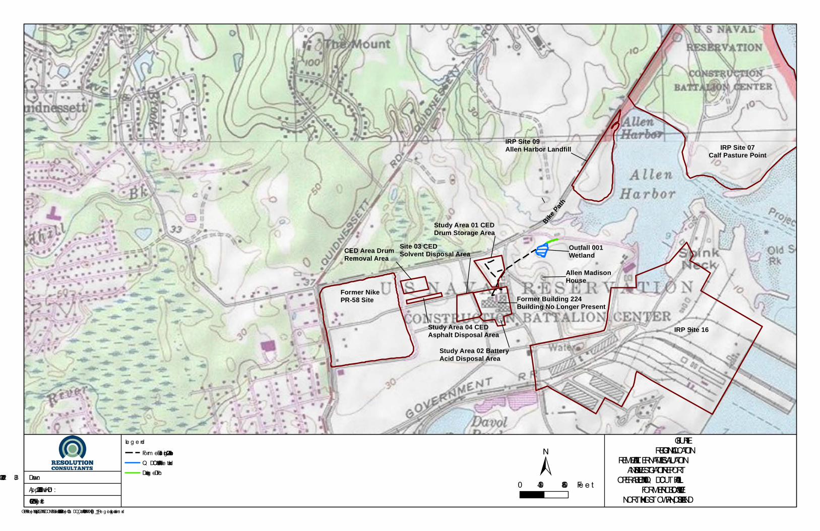
The RI Report presents a detailed site description and operational history; summarizes previous investigations; summarizes the scope of work completed in the RI; and presents the findings of the RI. This report will summarize the main findings presented in the RI; present remedial objectives; develop and screen remedial alternatives; and recommend the Navy’s preferred remedy. 1.1.1 Site Description QDC Outfall 001 is located in the central portion of the Former NCBC Davisville facility, to the west of Allen Harbor (Figure 1-1). QDC Outfall 001 is located near the parking lot at the end of Marine Road, behind a chain-link fence that surrounds the parking area for recreational users of parkland comprised of Calf Pasture Point and the former Allen Harbor Landfill. Undeveloped wetlands are present to the east of the outfall (Figure 1-2). Groundwater flow direction in the outfall area is toward the east. The Site, which consists of the outfall area, wetland, and downgradient drainage ditch, is currently undeveloped (Figure 1-2). Access to the QDC Outfall 001 area is currently impeded but not restricted by the chain link fence that surrounds the parking area located at the end of Marine Road. There are residential areas to the north of Marine Road. The closest residential property boundary is approximately 1,000 ft. northwest from the outfall; the closest residential property boundary due north is approximately 1,850 ft. from the outfall. The QDC reuse plan identifies the majority of the surrounding land as wetlands, with a future reuse as “open space/conservation”. Since the area is wetland contiguous to coastal features, any future activities in the area would be subject to the regulations of the Rhode Island Coastal Resource Management Council (RI CRMC). Some of the upland area adjacent to OU-10, such as the parking area for the bike trail, is proposed for “waterfront commercial” reuse (Quonset Development Corporation, 2008). 1.1.2 Operational History The Former NCBC Davisville was primarily used for training the Navy Construction Battalion “Seabees” in construction operations. The facility also served as freight yards and storage areas for construction materials. Based on a review of historical “as-built” drawings of drainage systems at the former NCBC, QDC Outfall 001 is the discharge point for an underground drainage pipeline that originates from the former Building 224 (see Figure 1-2). Building 224 was part of the Construction Equipment Department (CED) Area and was located approximately 1,000 feet
Remedial Alternatives Evaluation and Site Investigation Report Quonset Development Corporation, Operable Unit 10,
Former Naval Construction Battalion Center Davisville, North Kingstown, Rhode Island
March 2016
3
southwest of the outfall on land bounded by Seabee Avenue to the west, Perimeter Road to the north, Davisville Road to the south, and light wooded vegetation and the Allen Madison State Historic Site to the east. The former Building 224 and nearby truck wash pad and oil water separator are the presumed sources of contamination present in the outfall area. The building was used by the Navy as a vehicle-maintenance and truck-washing facility. Contaminants associated with materials used in these activities or in other historical activities conducted at the CED Area may have been disposed /released into the former Building 224 drainage system, discharging at QDC Outfall 001. 1.1.3 Key Physical Features This section summarizes the physical setting of the Site presented in the RI, including the surface features, geology, and hydrology. Surface Features Elevations in the general vicinity of the Site range from approximately 40 ft. above mean sea level in the former Building 224 area and Marine Road to approximately 10 ft. above mean sea level in the wetland area. Site topography generally slopes from west to east toward Allen Harbor and Narragansett Bay, with localized variations in the slope in the immediate vicinity of the outfall/wetland. The wetland area forms a localized topographic low where the ground surface dips from the west, the Quonset Bike Path parking area located to the north, and wooded areas located to the south. The wetland is covered by an organic mat of dead phragmites reeds, root mass, and other organic material (e.g., branches and other tree debris). The organic mat is thicker in the center of the wetland and tapers out near the edges. The forested wetland is approximately 1.5 acres in size. The downgradient ditch is approximately 300 feet long and 3 feet wide. Geology In the drainage ditch area, the shallow soil is dominated by silty sand (fine to medium/coarse), with gravel to varying degrees. A few RI borings exhibited a silt layer with thickness greater than 1 foot. Materials observed in the forested wetland area (i.e., where the drainage ditch is located) east of the QDC Outfall 001 emergent wetland ranged from silt to silty/fine sand, with little to some gravel. Upgradient locations west of Marine Road are characterized as having similar geologic conditions with varying layers of silt and silty fine sand.
Remedial Alternatives Evaluation and Site Investigation Report Quonset Development Corporation, Operable Unit 10,
Former Naval Construction Battalion Center Davisville, North Kingstown, Rhode Island
March 2016
4
Surface/Groundwater Hydrology The drainage system from the former Building 224 terminates to QDC Outfall 001 at the western end of the wetland area. The emergent wetland area is approximately 0.5 acre, with approximately 1.5 acres of surrounding forested wetland. Surface water levels in the wetland are a function of seasonal variation in precipitation and groundwater levels. Since the wetland accepts stormwater from a relatively large upgradient area, minor flooding may occur during high flow events. The wooden structure with the plugged culvert and the area of elevated land adjacent to it were removed by QDC in 2013 (see Drainage Ditch Modification in Section 1.1.4). The area exiting the northeast end of the wetland now forms a drainage ditch with a consistent grade towards the adjacent wetland and culvert that connects to Allen Harbor. When the water table is sufficiently high, surface water flows from the northeast corner of the wetland, down the drainage ditch to the adjacent wetland, and through the culvert directly to Allen Harbor. Shallow and intermediate groundwater generally flows from southwest to northeast, toward Allen Harbor and Narragansett Bay. The intermediate and deep groundwater flows at relatively high gradients (intermediate/deep — 0.15 ft. /ft., shallow — 0.013 ft. /ft.). Published values for hydraulic conductivity of silty sands range from 10-5 to 10-3 cm/s, while silt ranges from 10-6 to 10 4 cm/s (Fetter, 2001). Based on the materials and gradients present at the Site (assuming 30% porosity), the groundwater seepage velocity ranges between: • Silt seepage velocity = 1.42x10⁻⁴ ft. /day to 1.23x10⁻² ft. /day • Silty sand seepage velocity = 1.42x10⁻³ ft. /day to 1.23x10⁻¹ ft. /day 1.1.4 Previous Investigations Prior to the RI, the previous site related investigations and actions included the following: • Annual Groundwater Sampling (2001-2007) — The Navy conducted annual
groundwater monitoring of the deep overburden and bedrock aquifers at IRP Site 03 — CED Solvent Disposal Area to evaluate concentrations of chlorinated volatile organic compounds (CVOCs). The results of the sampling indicated that the majority of the CVOCs in groundwater beneath the CED Area are believed to be present as a result of a release from an upgradient property, the Former NIKE PR-58 US Army Corps of Engineers Formerly Utilized Defense Site. In addition, based on data from groundwater monitoring
Remedial Alternatives Evaluation and Site Investigation Report Quonset Development Corporation, Operable Unit 10,
Former Naval Construction Battalion Center Davisville, North Kingstown, Rhode Island
March 2016
5
wells in the area of QDC Outfall 001, the extent of CVOCs in the deep and bedrock aquifers does not extend beneath the QDC Outfall 001 wetland area (Johnson, 2011).
• 2008 QDC Maintenance Excavation - QDC excavated soils from the mouth of the QDC Outfall 001 during the summer of 2008 as part of storm water outfall maintenance activities. Since the soil removal was part of routine outfall maintenance activities conducted at the request of the Rhode Island Coastal Resource Management Council, QDC did not pre-notify EPA, RIDEM or the Navy. During the excavation of the soils, QDC noted staining and odor in the soils. The Navy was contacted and the soils were stockpiled. The Navy characterized and disposed of the stockpiled soils. A composite sample was collected from the soil stockpile and analyzed for waste characterization. Analytical results indicated the presence of TPH (>10,000 mg/kg), VOCs (primarily methyl-, chloro-, and propyl-benzenes), PCBs (0.3 mg/kg Aroclor-1260), PAHs, and metals (420 mg/kg lead). Based on the measurements of the open excavation, it is estimated that the 2008 excavation measured approximately 10 ft. wide by 23 ft. long by 2 ft. deep, yielding an estimated 17 cubic yards of excavated soil.
• NIKE PR-58 RI — Historic information is available in the NIKE PR-58 RI report
(Johnson, 2011). Incidental to their investigation of a CVOC plume, environmental samples were collected from two locations in the vicinity of the QDC outfall 001: groundwater well PGU-Z3-03D located to the north east of the outfall and pore water location PW-17/surface water location PWS-17 co-located at the end of the outfall. Low concentrations (estimated below the reporting limit) of benzene, toluene, ethylbenzene, and xylenes, and trimethylbenzene were detected in groundwater from PGU-Z3-03D. Samples PW-17 and PWS-17, co-located at the end of the QDC-001 outfall, were collected prior to the QDC excavation in 2008. Analytical results for the surface and pore water are consistent with analytical results of wetland sediment in the Drain Line Investigation Report.
• Drain Line Investigation (2010) — Tetra Tech NUS Inc. (Tetra Tech) conducted a
Drain Line Investigation (Tetra Tech, 2012) and Study Area Screening Evaluation. The investigation concluded the following:
Remedial Alternatives Evaluation and Site Investigation Report Quonset Development Corporation, Operable Unit 10,
Former Naval Construction Battalion Center Davisville, North Kingstown, Rhode Island
March 2016
6
— Remote video inspection of the drain line was conducted to document the condition of the pipeline along its length and to identify connections to other underground pipelines. The video investigation indicated that the drain pipeline is constructed of five-foot sections of pre-cast concrete pipe. The sections are cemented together around the male end of the pipe, where it is inserted into the “bell” or female end of the pipe. Overall, the underground drain pipeline appeared to be in very good condition, with very little evidence of damage. The system appears to have accepted drainage from nine catch basins along the approximate 1,100 feet of inspected drain line pipe. In addition, there are two lateral drain lines that connect to main drain line at Catch Basins CB-03 and CB-09 that accepted drainage from an additional six catch basins in Study Area 1 of the CED Area. These lateral drain lines did not undergo the remote video inspection, but were included in the Maintenance Cleaning described below.
— One test pit was excavated approximately 100 feet upstream of catch basin
CB-05 where remote video inspection of the drain line had shown evidence of water infiltration at a drain line joint. The results of the test pit and analytical sampling suggest that a release of contamination from the drain line did not occur at this location.
— Residual material samples were collected from the bottom of four
catch basins along the drain line and one residual material sample was collected from the end of the drain line approximately two feet in from QDC Outfall 001. The results of the sampling indicated that residual material primarily contained elevated concentrations (relative to the soil/sediment Project screening levels [PSLs]) of the volatile organic compounds (VOCs), Polycyclic or Polynuclear Aromatic Hydrocarbons (PAHs), Polychlorinated Biphenyls (PCBs), extractable total petroleum hydrocarbons, and metals.
— Five confirmatory soil samples were collected from the footprint of the
2008 excavation near the outlet of QDC Outfall 001. Confirmatory soil samples contained several petroleum constituents at concentrations exceeding the PSLs, including trimethylbenzene, Gasoline Range Organics
Remedial Alternatives Evaluation and Site Investigation Report Quonset Development Corporation, Operable Unit 10,
Former Naval Construction Battalion Center Davisville, North Kingstown, Rhode Island
March 2016
7
(GRO), extractable total petroleum hydrocarbons, and several PAHs. PCBs and metals were also detected in select soil samples at levels exceeding the PSLs. These sample locations and associated soils were removed when the 2008 excavation footprint was shaped in order to construct the containment basin during the 2012 maintenance cleaning (Resolution Consultants, 2014).
— Nine sediment samples were collected from the area of the wetland
immediately downstream of QDC Outfall 001. In select sediment samples, PAHs, PCBs and metals were detected above PSLs.
• EBS Review Item 53 — A former leach field that was addressed as EBS review item 53 is
present to the north and slightly downgradient of the wetland. Three test pits were excavated in the sludge beds of the leach field and samples were collected for TPH, GRO, VOCs, SVOCs, pesticides, PCBs, and Resource Conservation and Recovery Act eight metals. The detected VOCs, metals, and pesticides were below United States Environmental Protection Agency and RIDEM industrial/commercial screening criteria. TPH, GRO, VOCs, SVOCs, and PCBs were not detected (EA, 1995; EA, 1998). Since the former leach field is slightly downgradient of the wetland, impacts to the wetland would not be expected.
• Wetland Hand Auger Field Investigation (2013) — In January 2013,
Resolution Consultants advanced hand augers at three locations in an effort to investigate the composition (i.e., fill material or wetland sediment) and depth of the material in the wetland. The augers were advanced to depths ranging from 2.2 to 5 feet. The material observed in all three hand auger locations was organic freshwater wetland sediment, there was no fill layer observed. A total depth of the wetland sediment could not be determined using the hand augers, as the auger either hit refusal or the holes collapsed at their terminal depths. Elevated photoionization detector readings ranging from 20 — 100 parts per million and a petroleum odor were observed.
• Maintenance Cleaning — In December 2013, Resolution Consultants performed
maintenance cleaning of the drain line and associated catch basins that lead to QDC Outfall 001. All associated catch basins were cleaned with high pressure water and vacuumed out. The drain lines were then cleaned via high pressure water jetting and vacuuming. Details regarding the maintenance cleaning can be found in the
Remedial Alternatives Evaluation and Site Investigation Report Quonset Development Corporation, Operable Unit 10,
Former Naval Construction Battalion Center Davisville, North Kingstown, Rhode Island
March 2016
8
Maintenance Cleaning of the QDC Outfall 001 Drain Line and Associated Catch Basins Summary Report (Resolution Consultants, 2014).
• Drainage Ditch Modification — In July 2013 QDC, in coordination with the RI CRMC,
removed the wooden structure and plugged culvert and grubbed the Drainage Ditch creating a consistent grade from the northeast corner of the wetland to the adjacent wetland to the east (Tetra Tech EC, 2014).
Remedial Investigation - In accordance with CERCLA, the Navy completed a Remedial Investigation (RI) and summarized the findings in the RI Report (Resolution Consultants, 2015) which is included in Appendix A. The RI delineated the nature and extent of impacts to sediment and soil downgradient of the QDC Outfall 001. As part of the RI, a Human Health Risk Assessment (HHRA) and Ecological Risk Assessment (ERA) were completed. The RI concluded that based on the HHRA and ERA, there is marginal risk to receptors. However, there are TPH impacts to soil and sediment at OU-10 that exceed the R DEC for soil.
Remedial Alternatives Evaluation and Site Investigation Report Quonset Development Corporation, Operable Unit 10,
Former Naval Construction Battalion Center Davisville, North Kingstown, Rhode Island
March 2016
9
2.0 CONCEPTUAL SITE MODEL The primary contaminants identified during the RI consisted of metals, PAHs and pesticides. TPH while not a CERCLA contaminant, was also evaluated due to levels exceeding RIDEM standards. As stated in the RI, these constituents are likely present in the wetland soil and sediment due to the vehicle maintenance activities associated with former Building 224 and the truck wash pad. These contaminants likely entered the catch basin network at the former Building 224 area and discharged to the wetland and drainage ditch through QDC Outfall 001. Pesticides such as trans-chlordane, also present in the wetland, may have originated from other sources (e.g., routine use by the Navy). Remaining residual material was removed from the drainage network during the Maintenance Cleaning in December 2013. Remaining impacts to soil, sediment, and groundwater are described below. The Regional conceptual site model (CSM) is presented on Figure 2-1. The Site specific CSM is presented on Figure 2-2. Metals in Soil and Sediment The distribution of metals in soil in the vicinity of the outfall and wetland sediment was generally higher in surficial horizons with concentrations decreasing in the wetland sediments with depth and distance from the outfall. In the drainage ditch, concentrations generally decreased with distance from the wetland, and higher concentrations were often seen in deeper (1-2 and 2-4 ft. bgs) horizons of the samples, particularly in the samples collected upstream and downstream of the former wooden structure and plugged culvert. The wooden structure and plugged culvert were removed by QDC in July 2013. PAHs in Soil and Sediment The distribution of PAHs in soil in the vicinity of the outfall and wetland sediment was generally higher in surficial horizons with concentrations decreasing with depth and distance from the outfall. In the drainage ditch, higher concentrations were often seen in deeper horizons of the samples collected upstream of the former wooden structure and plugged culvert. At the end of the drainage ditch past the former wooden structure and plugged culvert, concentrations of PAHs were higher in the surficial horizon. The highest concentrations of PAHs were found near the former wooden structure and plugged culvert, indicating potential historical deposition. PAH concentrations were much lower downgradient of the former wooden structure and plugged culvert.
Remedial Alternatives Evaluation and Site Investigation Report Quonset Development Corporation, Operable Unit 10,
Former Naval Construction Battalion Center Davisville, North Kingstown, Rhode Island
March 2016
10
TPH in Soil and Sediment TPH generally follows a pattern similar to PAHs. Highest concentrations were found in the area near the outfall within the limits of the 2008 excavation. In the vicinity of the former wooden structure and plugged culvert, concentrations were higher in the deeper horizons and highest near the former wooden structure and plugged culvert. Downgradient of the former wooden structure and plugged culvert, concentrations decreased. TPH concentrations in the wetland sediment are generally higher in the surficial horizons, with concentrations decreasing with depth and distance from the outfall. Concentrations of TPH in soil and sediment are shown on Figure 2-3. Trans-chlordane in Soil and Sediment Trans-chlordane concentrations are generally higher in shallow sediment and soil samples than the deeper intervals. Concentrations in the shallow sediments are highest in the samples collected in east and south of the QDC Outfall 001 and in the shallow soil samples collected immediately outside the 2008 excavation area. With distance from the outfall, concentrations decrease. At the wetland discharge to the drainage ditch, the concentrations of trans-chlordane are non-detect in the shallow sediments, but detected in the 1-2 ft. interval. In the drainage ditch, concentrations of trans-chlordane were highest in the most downgradient sample. This anomaly may be the result of the reworking of soil in this area as part of the demolition of the former structures within the area and/or the grubbing of the drainage ditch by QDC in 2013. Metals in Groundwater Based on risk assessment results, the two primary metals of interest in groundwater at QDC Outfall 001 are iron and arsenic. As stated in the HHRA, a qualitative background evaluation using upgradient monitoring wells indicates that both metals may be regional and not related to site activities. Both arsenic and iron are commonly detected in regional groundwater. 2.1 Fate and Transport Characteristics of Site Contaminants The fate and transport of constituents in the QDC Outfall 001 wetland and surrounding area is driven by physical processes, such as seasonal variations in the water table and increased flows related to the high rain events and chemical processes such as sorption. The distribution of constituents generally reflects these processes, with concentrations higher near QDC Outfall 001 or in areas of suspected deposition, consistent with the CSM.
Remedial Alternatives Evaluation and Site Investigation Report Quonset Development Corporation, Operable Unit 10,
Former Naval Construction Battalion Center Davisville, North Kingstown, Rhode Island
March 2016
11
While leaching may be a secondary transport mechanism, the CSM is consistent in that the key constituents present in soil or sediment (metals, PAHs, and pesticides) do not appear to be leaching into groundwater to levels that would cause potential for human health risk, and do not appear to be migrating off-site. Overall, the low levels of iron and arsenic observed are not part of a systematic pattern and the groundwater quality is considered good. 2.2 Risk Assessment Summary Human health and ecological risk assessments completed as part of the RI determined that there is marginal risk to receptors from CERCLA contaminants (Resolution Consultants, 2015). However, the Navy recognizes that there are TPH impacts to soil and sediment at OU-10 that exceed the RIDEM R DEC for soil. On October 28, 2015, the Former NCBC Davisville BCT reached an agreement to remove the TPH impacted soil and sediment where it exceeds the RIDEM R DEC of 500 mg/kg. This action would also remove the co-located CERCLA contaminants that pose marginal risk. 2.3 Contaminated Volume Estimates Approximately 4,270 Cubic Yards (CY) of TPH impacted soil and sediment that exceeds the RIDEM R EC of 500 mg/kg is present on site. This estimate is based off of the areas presented on the RI figures and Figure 4-1 of this report. Table 2-1 below presents contaminated volumes by specific area and depth.
Table 2-1 Contaminated Volume Estimates
Area Excavation Depth (FT) Area (FT2) Volume (CY) Wetland Phragmites and Sediment 0-2 Feet 30,836 2,284
Remedial Alternatives Evaluation and Site Investigation Report Quonset Development Corporation, Operable Unit 10,
Former Naval Construction Battalion Center Davisville, North Kingstown, Rhode Island
March 2016
12
3.0 REMEDIAL OBJECTIVES Consistent with the RIDEM Remediation Regulations, the overall remedial objective is to provide protection of human health and the environment. The human health and ecological risk assessments completed as part of the RI determined that there is marginal risk to both human and ecological receptors from CERCLA-related contaminants in soil, sediment, groundwater, and surface water. However, TPH impacted soil and sediment that exceed the RIDEM Method 1 R DEC for soil are present at the Site. As such, the remedial objective identified for site sediment and soils are as follows: • Prevent human health and ecological exposure to soils and sediments impacted with
TPH concentrations that exceed the RIDEM Method 1 R DEC of 500 mg/Kg. Site groundwater and surface water are not considered media of concern. Concentrations of contaminants in groundwater did not exceeded MCLs or RIDEM GA groundwater classification standards. The HHRA and environmental risk assessment determined that concentrations of metals in surface water posed a marginal risk to potential receptors. The area where marginal risk was identified is co-located with sediments that exhibit TPH concentrations in excess of 500 mg/Kg and will be mitigated in conjunction with the remedial action.
Remedial Alternatives Evaluation and Site Investigation Report Quonset Development Corporation, Operable Unit 10,
Former Naval Construction Battalion Center Davisville, North Kingstown, Rhode Island
March 2016
13
4.0 DEVELOPMENT AND EVALUATION OF REMEDIAL ALTERNATIVES This section presents the remedial alternatives for the Site and evaluates them against the evaluation criteria in accordance with the RIDEM Remediation Regulations. As indicated in the conclusion of the RI, a remedial approach was agreed to by the Former NCBC Davisville BCT which included the removal of TPH impacted soil and sediment that exceeds the RIDEM R DEC of 500 mg/kg. Co-located CERCLA contaminants identified in the HHRA and ERA that pose marginal risk will also be removed. 4.1 Development of Remedial Alternatives Three remedial alternatives will be developed and evaluated as part of this RAE: • Alternative 1 — No Action • Alternative 2 — Excavation, Solid Waste Dewatering, and Solid Waste Disposal • Alternative 3 — Dewatering, Excavation, Solid Waste Dewatering, and Solid Waste Disposal Each of these remedial alternatives are developed further in the sections below. 4.1.1 Alternative 1 — No Action As required by the RIDEM Remediation Regulations, a no action alternative will be evaluated as part of this RAE. Under this alterative, no remedial action would be taken. 4.1.2 Alternative 2 — Excavation, Solid Waste Dewatering, and Disposal Alternative 2 will achieve the remedial objective by excavating soil and sediment that exceeds TPH concentrations of 500 mg/Kg. Solid waste will be disposed of at an off-site landfill. Waste will be dewatered or solidified with a drying agent such as Turface® MVP®prior to disposal. Under this remedial alternative, excavation activities will be conducted “in the wet”, as dewatering would not be conducted. Storm water and potentially groundwater would be managed under a water management plan during the implementation of the remedial activities. The main components of this remedy include the following: • Compliance sampling to confirm the extent of excavation prior to mobilization. • Sediment and erosion control.
Remedial Alternatives Evaluation and Site Investigation Report Quonset Development Corporation, Operable Unit 10,
Former Naval Construction Battalion Center Davisville, North Kingstown, Rhode Island
March 2016
14
• Management of storm water and potentially groundwater in accordance with a water management plan.
• Excavation of approximately 4,270 CY of impacted soils and sediments using conventional
excavation equipment. The excavation areas are shown on Figure 4-1. • Dewatering of the solid waste stream. • Onsite treatment and discharge of the aqueous waste stream. • Disposal of excavated and dewatered soils and sediment at an off-site landfill. • Connect the drainage ditch to the culvert at Former Westcott Road that drains to
Allen Harbor. • Site backfill and restoration to grade. • Wetland restoration. 4.1.3 Alternative 3 — Dewatering, Excavation, Solid Waste Dewatering, and Disposal Similar to Alternative 2, Alternative 3 will include the excavation of soil and sediment that exceeds TPH concentrations of 500 mg/kg. Solid waste will be disposed of at an off-site landfill. Waste will be dewatered or solidified with a drying agent such as Turface® MVP® prior to disposal. Under this remedial alternative, excavation activities will be conducted “in the dry”, as dewatering will be conducted. The aqueous waste stream will be treated and discharged onsite. Storm water would be managed under a water management plan during the implementation of the remedial activities. The main components of this remedy include the following: • Compliance sampling to confirm the extent of excavation prior to mobilization. • Sediment and erosion control. • Management of storm water in accordance with a water management plan.
Remedial Alternatives Evaluation and Site Investigation Report Quonset Development Corporation, Operable Unit 10,
Former Naval Construction Battalion Center Davisville, North Kingstown, Rhode Island
March 2016
15
• Localized dewatering of the excavation area. • Excavation of approximately 4,270 CY of impacted soils and sediments using conventional
excavation equipment. The excavation areas are shown on Figure 4-1. • Dewatering of the solid waste stream. • Onsite treatment and discharge of the aqueous waste stream. • Disposal of excavated and dewatered soils and sediment at an off-site landfill • Connect the drainage ditch to the culvert at Former Westcott Road that drains to
Allen Harbor. • Site backfill and restoration to grade. • Wetland restoration. 4.2 Evaluation of Each Alternative This section includes an evaluation of each alternative. Each alternative is evaluated against the criteria described in the RIDEM Remediation Regulations. • Protection of human health and the environment • Long-term effectiveness and permanence • Implement ability • Cost • Compliance with State laws, local laws, and regulations 4.2.1 Alternative 1 — No Action Alternative 1 consists of a no action alternative. Under this alternative, no remedial action will be taken and the Site would remain as is. This alternative provides a baseline for comparison to other alternatives.
Remedial Alternatives Evaluation and Site Investigation Report Quonset Development Corporation, Operable Unit 10,
Former Naval Construction Battalion Center Davisville, North Kingstown, Rhode Island
March 2016
16
Protection of Human Health and the Environment Alternative 1 is not protective of human health and the environment. TPH impacted and soil and sediment (and co-located CERCLA contaminants) will remain above the RIDEM R DEC of 500 mg/Kg and could present an exposure risk under current and future land uses. Long-Term Effectiveness and Permanence Alternative 1 is not effective or permanent as no action will be taken. TPH impacted and soil and sediment will remain above the RIDEM R DEC of 500 mg/Kg. These impacted media could be encountered during current and future land uses. Implementability This criterion does not apply to Alternative 1 as no remedial action will be taken. Cost The cost of Alternative 1 is assumed to be $0 as no remedial action will be taken. Compliance with State laws, local laws, and regulations Alternative 1 does not comply with State laws as TPH impacted soil and sediment will remain above the RIDEM R DEC of 500 mg/Kg. 4.2.2 Alternative 2 — Excavation, Solid Waste Dewatering, and Disposal Alternative 2 consists of excavating soil and sediment that exceeds TPH concentrations of 500 mg/Kg, dewatering and disposal of solid waste at an offsite landfill, storm water and groundwater management, onsite treatment and discharge of the aqueous waste stream from dewatering the excavated sediment, backfilling, and restoring the wetland and drainage ditch. Approximately 4,670 CY of sediment/soil will be removed. Compliance sampling will be completed prior to mobilization to confirm the extent of the excavation. In addition, the origin of a recently discovered outfall to the drainage ditch will be investigated to trace the location of this pipe to its origin. The outfall is located along the northern sidewall of the drainage ditch, approximately 50 feet downgradient of the wetland, in the vicinity of soil boring QF-SO10 (Figure 4-1). Excavation activities will be conducted in the wet as no dewatering would take place. Excavation activities will proceed cautiously to ensure that impacted soil and sediment do not get suspended into surface water/groundwater and redistributed outside of the wetland and
Remedial Alternatives Evaluation and Site Investigation Report Quonset Development Corporation, Operable Unit 10,
Former Naval Construction Battalion Center Davisville, North Kingstown, Rhode Island
March 2016
17
drainage ditch excavation areas. To mitigate this potential, excavation activities will be conducted in small cells and backfilled immediately upon completion. Additional measures such as a silt fence will be implemented at the drainage ditch, downgradient from the wetland excavation to prevent any suspended solids from leaving the wetland area during excavation activities. Sediment control measures will also be implemented. Storm water and potentially groundwater will be managed in accordance with a water management plan. Water management activities would include diverting any storm water discharged at QDC Outfall 001 around the wetland and drainage ditch to the culvert located at Former Westcott Road. The water management plan would provide provisions for the management of groundwater under a high water table condition and during backfill operations. Upon conclusion of the remedial activities, the wetland and drainage ditch will be restored. In addition, the end of the drainage ditch will be connected to the culvert at Former Westcott Road that drains to Allen Harbor by excavating an approximately 224 foot long ditch that is 2 feet deep by 3 feet wide. Approximately 50 CY of sediment will be removed from this section of the drainage ditch. This will allow for consistent drainage of the wetland and drainage ditch to Allen Harbor. Upon conclusion of the remedial action, the land usage will provide for unrestricted use. As such, institutional controls and subsequent monitoring will not be required. Overall Protection of Human Health and the Environment Alternative 2 is protective of human health and the environment. This alternative will meet the remedial objective by excavating soil and sediment that exceeds TPH concentrations of 500 mg/Kg, providing for unrestricted use upon conclusion of the remedial action. Long-Term Effectiveness and Permanence Alternative 2 will be effective at meeting the remedial objective as it will provide for unrestricted use upon conclusion of the remedial action. Alternative 2 is a permanent solution as the removal of TPH impacted soils and sediments will provide for unrestricted land use. Implementability Alternative 2 is easily implemented using common construction equipment. Excavation activities will proceed cautiously to ensure that impacted soils do not get suspended into surface water/groundwater and redistributed outside of the excavation area.
Remedial Alternatives Evaluation and Site Investigation Report Quonset Development Corporation, Operable Unit 10,
Former Naval Construction Battalion Center Davisville, North Kingstown, Rhode Island
March 2016
19
Cost The total cost for Alternative 2 is estimated to range from $1,468,000 to $1,762,000. A preliminary cost estimate is included as Appendix B. This range of total cost includes capital costs and contingency. Capital Cost — $1,468,000 Contingency (20%) — $294,000 Compliance with State laws, local laws, and regulations Alternative 2 will comply with State laws, local laws, and regulations associated with the remedial activity including but not limited to the Remediation Regulations, applicable wetland regulations, and applicable waste treatment and disposal regulations. Table 4-1 presents the likely State and Federal Laws that will apply to the implementation of this alternative.
Requirement Requirement Synopsis Action to be taken
State of Rhode Island Rules and Regulations for the Investigation and Remediation of Hazardous Material Releases (Short Title: Remediation Regulations)
These regulations set direct contact and leachability remediation standards for soil and also provide guidnance and requirementsfrom investigation through the remedy implementation.
Soil Residential Direct Exposure Criteria (R DEC) for TPH were used in the development of the remedy. Remedial implementation will be developed using the Remediation Regulations.
The State of Rhode Island Coastal Resources Management Program (RIGL 46-23-1 et seq) Sets standards for management and protection of coastal resources. The entire site is located in a coastal resource management area; therefore, applicable coastal resource management requirements need to be addressed. Excavation will be performed according to these requirements.
Water Pollution Control, Water Quality Regulations RIGL 42-16 et seq. ; CRIR 12-190-001 Provides water classification for surface waters in Rhode Island and sets ambient water quality criteria for toxic substances and governs water quality impacts associated with Site activities. The remedial action must be conducted so that there are no exceedances of water quality standards.
RI Air Pollution Control Regulation No. 7: Emissions of Air Detrimental to Persons or Property, RIGL 23-23e t seq. ; CRIR 12-31-07
Prohibits emissions of contaminants that may be injurious to human, plant, or animal life or cause damage to property or which unreasonably interfere with the enjoyment of life and property. Remediation activities may result in emissions. Appropriate measure would need to be taken to comply with these regulations.
RI Air Pollution Control Regulation No. 22: Air Toxics Guidelines and Air Modeling Guidelines, RIGL 23-23 et seq. ; CRIR 12-31-22
Prohibits emissions of specified contaminants that result in ground level concentrations greater than ambient level concentrations.
Remediation activities may result in emissions of toxics to the atmosphere if these contaminants are present in soil. Appropriate measures would need to be taken to comply with these regulations.
Protection of Wetlands (Executive Order 11990), 44 C.F.R. Part 9 Federal agencies are required to avoid adversely impacting wetlands unless there is no practicable alternative and the proposed action includes all practicable measures to minimize harm to wetlands that may result from such use.
Action to be taken will minimize alterations to protected resource areas. Mitigation measures, as required, will be taken to compensate for the resource areas altered by this alternative.
44 CFR Part 9 - Executive Order 11988 RE: Floodplain Management The Order requires Federal agencies to evaluate the potential effects of actions it may take within a designated 100-year floodplain of a waterway to avoid adversely impacting floodplains wherever possible. Floodplain impacts will be minimized and mitigated as appropriate.
Coastal Zone Management Act (16 USC Parts 1451 et. Seq) Requires that any actions must be conducted in a manner consistent with state approved management programs. The entire site is located in a coastal zone management area; therefore, applicable coastal zone management requirements need to be addressed. Soil excavation will be performed according to these requirements.
Management of Undesirable Plants on Federal Lands (7 USC 2814) Requires federal agencies to establish integrated management systems to control or contain undesirable plant species on federal lands under the agency’s jurisdiction.
Measures will be taken to control the establishment of Phragmites, or other invasive plants within all remediated areas. An invasive species control plan will be developed as part of the long-term O&M for this site.
Endangered Species Act (87 Stat. 884, as amended: 16 U.S.C. 1531, et seq.) Requires action to avoid jeopardizing the continued existence of listed endangered or threatened species or modification of their habitat. Conduct a habitat assessment for the northern long-eared bat.
Table 4-1Potentially, Applicable State, Local, and Federal Regulations
Establishes the specifications for discharging pollutants from any point source into the waters of the U.S. Also, includes stormwater standards for activities disturbing more than one acre.
Any water discharged to surface water bodies during remedial activities such as dewatering will comply with this regulation. Best management practices will be used to meet stormwater standards during the remedial action. Clean Water Act – National Pollutant Discharge Elimination System (NPDES), 40 C.F.R. Parts 122 and 125
Defines and establishes provisions for the protection of swamps, marshes, 100-year floodplain and other fresh water wetland resource areas in the state. Actions are required to prevent the undesirable drainage, excavation, filling, alteration, encroachment or any other form of disturbance or destruction of a wetland. Also establishes standards for land within 50 feet of the edge of state-regulated wetlands.
The remedy will be implemented in compliance with this requirement.
Requires action to take into account effects on properties included on or eligible for the National Register of Historic Places and minimizes harm to National Historic Landmarks.
Features with potential historical/cultural significance will be evaluated during the remedial design phase and activities will be coordinated with the State Agency, as required.
Requires Federal agencies involved in actions that will result in the control of structural modification of any stream or other federal waters for any purpose to take action to protect fish and wildlife resources that may be affected by the action.
Measures to mitigate or compensate adverse project related impacts to fish and wildlife resources will be taken, if determined necessary.
National Historical Preservation Act, U.S.C. 469 et seq. ; 36 C.F.R. Part 65When a federal agency finds, or is notified, that its activities in connection with a federal construction project may cause irreparable loss or destruction of significant scientific, pre-historical, historical, or archeological data, the substantive standards under the Act will be met.
If, during the remedial design or remedial action, it is determined that this alternative may cause irreparable loss or destruction of significant scientific, pre-historical, historical, or archaeological data, substantive standards under the Act will be met.
Requires that reasonable measures be taken to prevent particulate matter from becoming airborne. Remediation activities could potentially result in fugitive dust. Appropriate measures would need to be taken to prevent particulate matter from becoming airborne.
Federal Requirements
RI Air Pollution Control Regulation No. 5: Fugitive Dust, RIGL 23-23 et seq.; CRIR 12- 31-05
Fish and Wildlife Coordination Act, 16 U.S.C. §661 et seq.
State Requirements
Rhode Island Fresh Water Wetlands Act, RIGL 2-1, Sections 2-1-18 through 2-1-20.2; DEM Rules And Regulations Governing the Administration And Enforcement of the Fresh Water Wetlands Act (Dec 2010), Rules 4.00 and 5.00
Rhode Island Historic Preservation Act, RIGL 42-45 et seq.
Rules and Regulations for Dredging and Management of Dredge Materials, DEM-OWR-DR-203
Water Pollution Control - Pollution Discharge Elimination Systems, RIGL 42-16 et seq. ; CRIR 12-190-003 Rule 31
Addresses dredging activities and disposal of dredge spoils. Any excavation of sediment, dewatering, and disposal of sediments will comply with the requirements of these standards.
Sets requirements for discharges to surface waters and to protect waters from discharges of pollutants. Includes storm water requirements for construction projects that disturb over one acre.
Any water discharged to surface water bodies during remedial activities such as sediment dewatering will comply with this regulation. Best management practices will be used to meet stormwater standards during the remedial action.
Remedial Alternatives Evaluation and Site Investigation Report Quonset Development Corporation, Operable Unit 10,
Former Naval Construction Battalion Center Davisville, North Kingstown, Rhode Island
March 2016
20
4.2.3 Alternative 3 — Dewatering, Excavation, Solid Waste Dewatering, and Disposal Alternative 3 consists of excavating soil and sediment that exceeds TPH concentrations of 500 mg/Kg, dewatering and disposal of solid waste at an offsite landfill, storm water management, onsite treatment and discharge of the aqueous waste stream from dewatering, backfilling, and restoring the wetland and drainage ditch excavation areas. Approximately 4,670 CY of sediment/soil will be removed. Compliance sampling will be completed prior to mobilization to confirm the extent of the excavation. In addition, the origin of a recently discovered outfall to the drainage ditch will be investigated to trace the location of this pipe to its origin. The outfall is located along the northern sidewall of the drainage ditch, approximately 50 feet downgradient of the wetland, in the vicinity of soil boring QF-SO10 (Figure 4-1). Excavation activities will be conducted in the dry as localized dewatering would take place. Excavation activities will be conducted in small cells and backfilled immediately upon completion. Surface water/groundwater will be collected in sumps and/or drains within each of the cells. The surface water/groundwater will be pumped through onsite treatment and discharged to the culvert at Former Westcott Road (Figure 4-1) that leads to Allen Harbor downgradient of the drainage ditch. The groundwater treatment system will likely consist of a sedimentation tank, particulate filters, and carbon treatment to remove suspended solids, metals, and potential contaminants that may desorb from soil and sediment during excavation. Sediment control measures will also be implemented. Storm water will be managed in accordance with a water management plan. Water management activities would include diverting any storm water discharged at QDC Outfall 001 around the wetland and drainage ditch to the culvert located at Former Westcott Road. Upon conclusion of the remedial activities, the wetland and drainage ditch will be restored. In addition, the end of the drainage ditch will be connected to the culvert at Former Westcott Road that drains to Allen Harbor by excavating and approximately 224 foot long ditch that is 2 feet deep by 3 feet wide. Approximately 50 CY of sediment will be removed from this section of the drainage ditch. This will allow for consistent drainage of the wetland and drainage ditch to Allen Harbor. Upon conclusion of the remedial action, the land usage will provide for unrestricted use. As such, institutional controls and subsequent monitoring will not be required.
Remedial Alternatives Evaluation and Site Investigation Report Quonset Development Corporation, Operable Unit 10,
Former Naval Construction Battalion Center Davisville, North Kingstown, Rhode Island
March 2016
22
Overall Protection of Human Health and the Environment Alternative 3 is protective of human health and the environment. This alternative will meet the remedial objective by excavating soil and sediment that exceeds TPH concentrations of 500 mg/Kg and providing for unrestricted use upon conclusion of the remedial activities. Surface water/groundwater will be controlled during excavation activities using localized dewatering, mitigating the potential to re-distribute contaminates through surface water/ groundwater transport. Long-Term Effectiveness and Permanence Alternative 3 will be effective at meeting the remedial objective as it would provide for unrestricted use upon conclusion of the remedial action. Alternative 3 is a permanent solution as the removal of TPH impacted soils and sediments will provide for unrestricted land use. Implementability Alternative 3 is can be implemented using common construction and dewatering equipment. The implementation of the dewatering component could be challenging due to the hydraulics of the wetland that is in close proximity to Allen Harbor. Dewatering activity has the potential to be extensive and may need to account for a substantial volume of water. Cost The total cost for Alternative 3 is estimated to range from $1,608,000 to $1,930,000. A preliminary cost estimate is included as Appendix B. This range of total cost includes capital costs and contingency. Capital Cost — $1,608,000 Contingency (20%) — $322,000 Compliance with State laws, local laws, and regulations Alternative 3 will comply with State laws, local laws, and regulations associated with the remedial activity including but not limited to the Remediation Regulations, applicable wetland regulations, applicable dewatering regulations, and applicable waste treatment and disposal regulations. Table 4-1 presents the likely State and Federal Laws that will apply to the implementation of this alternative.
Remedial Alternatives Evaluation and Site Investigation Report Quonset Development Corporation, Operable Unit 10,
Former Naval Construction Battalion Center Davisville, North Kingstown, Rhode Island
March 2016
22
5.0 COMPARISON OF ALTERNATIVES AND RECOMMENDED ALTERNATIVE Three alternatives were developed in Section 4 and evaluated against the evaluation criteria. The Navy does not consider Alternative 1 — No Action, a viable alternative as it is not protective of human health and the environment and does not meet the remedial objective or the evaluation criteria. Alternative 2 and Alternative 3 each meet the remedial objective by excavating soils and sediments that exceed TPH concentrations of 500 mg/Kg. Alternative 2 and Alternative 3 are equally protective of human health and the environment and meet federal, state and local regulations. Upon completion of the remedial action, each alternative will restore the Site to unrestricted use. Alternative 3 is less favorable due to the challenges related to dewatering the wetland in close proximity to Allen Harbor. Alternative 3 is also more costly. Alternative 2 is more favorable as storm water and groundwater will be managed during remedial activity and not fully dewatering the excavation areas. As such, Alternative 2 — Excavation, Solid Waste Dewatering, and Disposal, is the Navy’s preferred alternative. Upon approval of this RAE and SIR, the selected remedial alternative will be further developed within a Remedial Action Work Plan and a Phase 1 Northern Long-Eared Bat Summer Habitat Assessment will be submitted to the local office of the United States Fish and Wildlife Service. The Navy intends to complete this alternative during the dry season in an effort to limit the amount of water management and to avoid the active season of the northern long eared bat.
Remedial Alternatives Evaluation and Site Investigation Report Quonset Development Corporation, Operable Unit 10,
Former Naval Construction Battalion Center Davisville, North Kingstown, Rhode Island
March 2016
23
6.0 REFERENCES Department of Navy Environmental Restoration Program Manual. August 2006. EA Engineering, Science, and Technology. Final Base wide Environmental Baseline Survey,
Naval Construction Battalion Center (NCBC) Davisville, North Kingstown, Rhode Island. October 1995.
EBS Review Item 53 Investigation. June 1998.
Fetter, C.W., Applied Hydrogeology (4th ed.), Prentice-Hall, Upper Saddle River, New Jersey. 2001 The Johnson Company, Inc. Draft Remedial Investigation Report, Former Nike Battery PR-58 Site,
North Kingstown, Rhode Island. October 2011. Quonset Development Corporation. Quonset Business Park Master Land Use and Development Plan.
Adopted October 2008. Resolution Consultants. Final Summary Report, Maintenance Cleaning of the QDC Outfall 001
Drain Line and Associated Catch Basins, Former Naval Construction Battalion Center Davisville, North Kingstown, Rhode Island. March 2014.
Former Naval Construction Battalion Center Davisville, North Kingstown, Rhode Island. November 2015.
State of Rhode Island and Providence Plantations. Department of Environmental Management.
Office of Waste Management. Rules and Regulations for the Investigation and Remediation of Hazardous Material Releases. November 2011. “Remediation Regulations”
Tetra Tech. Drain Line Investigation and Data Report for Former CED Area/QDC Outfall 001,
Former Naval Construction Battalion Center Davisville, North Kingstown, Rhode Island. Revision 1. November 2012.
Draft Remedial Action Completion Report for the Time Critical Removal Action at
Site 3, Former Naval Construction Battalion Center Davisville, North Kingstown, Rhode Island. June 2014.
Figures
FIGURE 1-1REGIONAL LOCATION
REMEDIAL ALTERNATIVES EVALUATIONAND SITE INVESTIGATION REPORT
OPERABLE UNIT 10 – Q DC OUTFALL 001FORMER NCBC DAVISVILLE
NORTH KINGSTOWN, RHODE ISLANDProje ct #: 60273164P:\Govt\Projects\NavyCLEAN AECOM-EnSafe JV\Davisville\GIS\Proje cts\Q DC_Outfall001\RAA\MXD\Fig _1_1_Re g ional_Location.m xd
Drawn: JB 02/23/2016Approve d : KD 02/23/2016
IRP Site 09 Allen Harbor Landfill IRP Site 07
Calf Pasture Point
IRP Site 16
Outfall 001Wetland
Le g e ndForm e r Build ing 224 DrainlineQ DC Outfall 001 We tlandDrainag e Ditch
Allen Madison House
Bike Path
Former Building 224Building No Longer Present
0 860430 Fe e t
Former Nike PR-58 Site
CED Area Drum Removal Area
Study Area 04 CEDAsphalt Disposal Area
Study Area 02 BatteryAcid Disposal Area
Study Area 01 CEDDrum Storage Area
Site 03 CEDSolvent Disposal Area
Alle n Mad ison House
CB-08CB-01
CB-02 CB-07CB-06
CB-03
CB-09CB-04CB-09-01
CB-09-02CB-03-01
CB-03-03 CB-03-03CB-03-04
0 200100Scale in Fe e t
FIGURE 1-2SITE LAYOUT
REMEDIAL ALTERNATIVES EVALUATIONAND SITE INVESTIGATION REPORT
OPERABLE UNIT 10 – Q DC OUTFALL 001FORMER NCBC DAVISVILLE
R EMEDIAL ALTER NATIVES EVALUATIONAND SITE INVESTIGATION R EPOR T
OPER ABLE UNIT 10 – QDC OUTFALL 001FOR MER NCBC DAVISVILLE
NOR TH KINGSTOWN, R HODE ISLAND
QF-SD30
QF-SD10
QF-SD11
QF-SD13
QF-SD12
QF-SD14
QF-SD18
QF-SD15
QF-SD19
QF-SD20
QF-SD31
QF-SD16
QF-SD23
QF-SD21
QF-SD17
QF-SD26
QF-SD24
QF-SD22
QF-SD27
QF-SD25
QF-SD29
QF-SD28
QF-SO06
QF-SO14
QF-SO09
QF-SO11
QF-SO12
QF-SO07
QF-SO18
QF-SO19
QF-SO16
QF-SO17
QF-SO21
QF-SO20
QF-SO22
QF-SO23
QF-SO24
QF-S010
QF-SO13
QF-SO15
QF-SO08
0 4020Sca le in Feet
FIGU RE 2-3TPH IN SOIL AND SEDIM ENT
REM EDIAL ALTERNATIV ES EVALU ATIONAND SITE INV ESTIGATION REPORT
OPERABLE U NIT 10 – QDC OU TFALL 001FORM ER NCBC DAV ISV ILLE
NORTH KINGSTOWN, RHODE ISLANDProject #: 60273164
Dra wn: JB 01/27/2016Approved: KD 01/27/2016
Pa th: P:\Govt\Projects\Na vyCLEAN AECOM -EnSa fe JV \Da visville\GIS\Projects\QDC_ Outfa ll001\RAA\M XD\Fig_2_ 3_TPH_ DRO_Soil_Sedim ent.m xd
LegendQDC Outfa ll 001
Form er Wooden Structure a nd Plugged Culvert
QDC Outfa ll 001 Wetla ndDra ina ge Ditch2008 Exca va tion Area
Form er Building 224 Dra in LineNoteScreening b enchm a rks presented for inform a tion only.Exceeda nce of a b enchm a rk does not indica te risk.See the risk a ssessm ents in Appendices C a nd D foreva lua tion of potentia l risks.Benchm a rk = (RIDEM R/DEC).
Depth Interva ls (feet)0-0.51-22-44-66-8
0.5-1
Not Sa m pledNot Detected
Detect Over 100X Screening Benchm a rk (50,000 m g/kg)Detect Over 10X Screening Benchm a rk (5,000 m g/kg)Detect Over 1X Screening Benchm a rk (500 m g/kg)Detect Below Screening Benchm a rk (500 m g/kg)
Culvert toAllen Ha rb or
U nknownOutfa ll
QF-SD30
QF-SD10
QF-SD11
QF-SD13
QF-SD12
QF-SD14
QF-SD18
QF-SD15
QF-SD19
QF-SD20
QF-SD31
QF-SD16
QF-SD23
QF-SD21
QF-SD17
QF-SD26
QF-SD24
QF-SD22
QF-SD27
QF-SD25
QF-SD29
QF-SD28
QF-SO06
QF-SO14
QF-SO09
QF-SO11
QF-SO12
QF-SO07
QF-SO18
QF-SO19
QF-SO16
QF-SO17
QF-SO21
QF-SO20
QF-SO22
QF-SO23
QF-SO24
QF-S010
QF-SO13
QF-SO15
QF-SO08
0 5025Sca le in Feet
FIGU RE 4-1ALTERNATIV E 2 AND ALTERNATIV E 3 SOILAND SEDIM ENT EXCAV ATION AREAS REM EDIAL ALTERNATIV ES EVALU ATIONAND SITE INV ESTIGATION REPORT
OPERABLE U NIT 10 – QDC OU TFALL 001FORM ER NCBC DAV ISV ILLE
NORTH KINGSTOWN, RHODE ISLANDProject #: 60273164
Dra wn: JB 05/02/2016Approved: KD 05/02/2016
Pa th: P:\Govt\Projects\Na vyCLEAN AECOM -EnSa fe JV \Da visville\GIS\Projects\QDC_ Outfa ll001\RAA\M XD\Fig_4_ 1_TPH_ DRO_Soil_Sedim ent_ Ex_Area s_ 20160502.m xd
QDC Outfa ll 001
Form er Wooden Structurea nd Plugged Culvert
QDC Outfa ll 001 Wetla ndDra ina ge DitchNew Dra ina ge Ditch2008 Exca va tion Area
Form er Building 224 Dra in LineProposed Excavation Boundary
Exca va te to 4 feetExca va te to 2 feetHa b ita t Restora tion
NoteScreening b enchm a rks presented for inform a tion only.Exceeda nce of a b enchm a rk does not indica te risk.See the risk a ssessm ents in Appendices C a nd D foreva lua tion of potentia l risks.Benchm a rk = (RIDEM R/DEC).
Depth Interva ls (feet)0-0.51-22-44-66-8
0.5-1
Not Sa m pledNot Detected
Detect Over 100X Screening Benchm a rk (50,000 m g/kg)Detect Over 10X Screening Benchm a rk (5,000 m g/kg)Detect Over 1X Screening Benchm a rk (500 m g/kg)Detect Below Screening Benchm a rk (500 m g/kg)
Appendix A Remedial Investigation Report
(Provided Electronically)
Appendix B Remedial Cost Estimates
Item No. Description Unit Cost Unit Estimated Quantity Estimated Cost
001 PRECHARATERIZATION (ANALYTICAL & DRILLING SUBCONTRACTOR) 40,000.00$ LS 1 40,000.00$
002 MOBILIZATION 140,000.00$ LS 1 140,000.00$
003 SITE SETUP AND CLEARING 100,000.00$ LS 1 100,000.00$ 004 EXCAVATION AND SEDIMENT DEWATERING 80.00$ CY 4,267 341,360.00$
005 WATER MANAGEMENT 20,000.00$ Month 2 40,000.00$
006 TRANSPORTATION AND DIPOSAL 40.00$ Ton 6,827 273,080.00$
007 BACKFILL 70.00$ CY 4,267 298,690.00$
008 SITE AND HABITAT RESTORATION 105,000.00$ LS 1 105,000.00$
009 DEMOBILIZATION 120,000.00$ LS 1 120,000.00$
010 ANALYTICAL COST (SOLID WATE DISPOSAL) 10,000.00$ LS 1 10,000.00$
1,468,130.00$ 1,761,756.00$
One CY is equal to 1.6 Ton.CY = Cubic YardLS = Lump Sum
Remedial Cost Estimate for Alternative 2 — Excavation, Solid Waste Dewatering, and Disposal
Notes:
TotalContingency + 20%
This is a feasibility study level cost estimate, based upon available information. Staging area is within close proximity to the work area (no more than 1,000 yards)Ample area to construct 2 sediment dewatering areas near the work area approx. 200' x 200' eachSite restoration is based on available information, revegetation is based on limited planting of tree saplings and native vegetation
Item No. Description Unit Cost Unit Estimated Quantity Estimated Cost
001 PRECHARATERIZATION (ANALYTICAL & DRILLING SUBCONTRACTOR) 40,000.00$ LS 1 40,000.00$
002 MOBILIZATION 150,000.00$ LS 1 150,000.00$
003 SITE SETUP AND CLEARING 100,000.00$ LS 1 100,000.00$
004 EXCAVATION AND SEDIMENT DEWATERING 80.00$ CY 4,267 341,360.00$
005 DEWATERING & WATER MANAGEMENT 75,000.00$ Month 2 150,000.00$
006 TRANSPORTATION AND DIPOSAL 40.00$ Ton 6,827 273,080.00$
007 BACKFILL 70.00$ CY 4,267 298,690.00$
008 SITE AND HABITAT RESTORATION 105,000.00$ LS 1 105,000.00$
009 DEMOBILIZATION 120,000.00$ LS 1 120,000.00$
010 ANALYTICAL COST (SOLID WASTE DISPOSAL AND DEWATERING COMPLIANCE) 30,000.00$ LS 1 30,000.00$
1,608,130.00$ 1,929,756.00$
This is a feasibility study level cost estimate, based upon available information. Staging area is within close proximity to the work area (no more than 1,000 yards)
One CY is equal to 1.6 Ton.CY = Cubic YardLS = Lump Sum
Remedial Cost Estimate for Alternative 3 — Dewatering, Excavation, Solid Waste Dewatering, and Disposal
Ample area to construct 2 sediment dewatering areas near the work area approx. 200' x 200' eachSite restoration is based on available information, revegetation is based on limited planting of tree saplings and native vegetation
Notes:
TotalContingency + 20%
Appendix C Site Investigation Report Checklist
Last Update: 1/31/2014
APPENDIX “I”
Section 7 of the "Remediation Regulations" Site Investigation Report (SIR) Checklist
(The following information shall be completed and submitted with the SIR) Contact Name: Contact Address: Contact Telephone: Site Name: Site Address:
DIRECTIONS: The box to the left of each item listed below is for the administrative review of the SIR submission and is for RIDEM USE ONLY. Under each item listed below, cross-reference the specific sections and pages in the SIR that provide detailed information that addresses each stated requirement. Failure to include cross-references shall delay review and approval. If an item is not applicable, simply state that it is not applicable and provide an explanation in the SIR.
� 7.03.A. List specific objectives of the SIR related to characterization of the Release, impacts of the Release and remedy.
� 7.03.B. Include information reported in the Notification Of Release. A copy of the Release notification
form should be included in the SIR. Include information relating to short-term response, if applicable.
� 7.03.C. Include documentation of any past incidents, releases, or investigations.
� 7.03.D. Include list of prior property Owners and Operators including past uses of the property, sequencing of property transfers and time periods of occupancy. Include supporting documentation.
� 7.03.E. Include previously existing environmental information which characterizes the Contaminated-Site and all information that led to the discovery of the Contaminated-Site.
� 7.03.F. Include current uses and zoning of the Contaminated-Site, including brief statements of
operations, processes employed, waste generated, Hazardous Materials handled, and any residential activities on the site, if applicable. (This section should be linked to the specific objectives section demonstrating how the compounds of concern in the investigation are those that are used or may have been used on the site or are those that may have impacted the site from an off-site source.)
� 7.03.G. Include a locus map showing the location of the site using US Geological Survey 7.5-min
OFFICE USE ONLY SITE INVESTIGATION REPORT (SIR) SITE: PROJECT CODE: SIR SUBMITTAL DATE: CHECKLIST SUBMITTAL DATE:
jparillo
Typewritten Text
jparillo
Typewritten Text
Operable Unit 10, QDC Outfall 001
jparillo
Typewritten Text
Former Naval Construction Battalion Center Davisville
jparillo
Typewritten Text
jparillo
Typewritten Text
Objectives are discussed in Section 1.1 of the Remedial Investigation Report (RIR) included as Appendix A of the Remedial Alternatives Evaluation (RAE) and SIR. Remedial Objectives are provided in Section 3 of the RAE and SIR.
jparillo
Typewritten Text
jparillo
Typewritten Text
jparillo
Typewritten Text
Not Applicable. Previously the Site investigation and remedial activity was conducted under the Navy's BRAC Program which follows CERCLA.
jparillo
Typewritten Text
jparillo
Typewritten Text
jparillo
Typewritten Text
jparillo
Typewritten Text
jparillo
Typewritten Text
jparillo
Typewritten Text
Previous Site history is documented in Section 1.4 of the RIR (Appendix A).
jparillo
Typewritten Text
jparillo
Typewritten Text
Base history is presented in Section 1.3 of the RIR (Appendix A). Sanborn Maps and Aerial Photos have not been provided due to the Site being a former Naval base.
jparillo
Typewritten Text
Environmental history is presented in Section 1.4 of the RIR (Appendix A).
jparillo
Typewritten Text
jparillo
Typewritten Text
jparillo
Typewritten Text
jparillo
Typewritten Text
Section 3 of the RIR (Appendix A) presents current land uses and site characteristics. Section 4 presents the nature and extent of contamination, and Section 5 presents the chemical fate and transport.
jparillo
Typewritten Text
jparillo
Typewritten Text
jparillo
Typewritten Text
jparillo
Typewritten Text
jparillo
Typewritten Text
Jeffrey Dale, NAVFAC BRAC PMO East
jparillo
Typewritten Text
4911 South Broad Street, Philadelphia, PA 19112
jparillo
Typewritten Text
215-897-4914
jparillo
Typewritten Text
jparillo
Typewritten Text
Last Update: 1/31/2014
quadrangle map or a copy of a section of that USGS map.
� 7.03.H. Include a site plan, to scale, showing:
� Buildings � Activities � Structures � North Arrow � Drinking Water Wells � Monitoring Wells � UIC Systems, septic tanks, USTs (former and current), piping and other underground structures � Groundwater Flow Direction � Outdoor Hazardous Materials storage and handling areas � Extent of paved areas � Location of environmental samples taken with analytical results, including soil borings, test pits, and
groundwater monitoring wells, highlighting any exceedences with the corresponding sample depth and medium listed
� Waste management and disposal areas � Lot Lines � Property Lines
� 7.03.I. Include a general characterization of the property surrounding the area including, but not limited
to:
� Location and distance to any surface water bodies within 500 ft of the site � Location and distance to any Environmentally Sensitive Areas within 500 ft of the site � Actual sources of potable water for all properties immediately abutting the site � Location and distance to all public water supplies, which have been active within the previous 2
years and within one mile of the site � Determination as to whether the Release impacts any off-site area utilized for residential or
industrial/commercial property or both � Determination of the underlying groundwater classification and, if the classification is GB, the
jparillo
Typewritten Text
See Figure 1-1 of the RAE and SIR and Figure 1-1 of the RI (Appendix A).
jparillo
Typewritten Text
The items below are presented on various figures in the RIR (Appendix A) and Figure the RAE & SIR.
jparillo
Typewritten Text
jparillo
Typewritten Text
jparillo
Typewritten Text
jparillo
Typewritten Text
jparillo
Typewritten Text
jparillo
Typewritten Text
jparillo
Typewritten Text
jparillo
Typewritten Text
jparillo
Typewritten Text
jparillo
Typewritten Text
jparillo
Typewritten Text
jparillo
Typewritten Text
jparillo
Typewritten Text
jparillo
Typewritten Text
RIR Figure 1-2
jparillo
Typewritten Text
jparillo
Typewritten Text
RIR Figure 2-1, 2-2, 2-3, 2-4, 2-5a-d, and 2-6 presents boring, surface water and sediment, groundwater sample, and temporary locations.
jparillo
Typewritten Text
jparillo
Typewritten Text
RIR Figure 1-2
jparillo
Typewritten Text
Various
jparillo
Typewritten Text
Not Applicable as drinking water wells are not located in the vicinity of the site.
jparillo
Typewritten Text
RIR Figure 2-3 and 2-4
jparillo
Typewritten Text
jparillo
Typewritten Text
jparillo
Typewritten Text
Groundwater flow information is presented RIR Figures 2-5a, b, c, and d.
jparillo
Typewritten Text
jparillo
Typewritten Text
jparillo
Typewritten Text
jparillo
Typewritten Text
jparillo
Typewritten Text
RIR Figure 1-2.
jparillo
Typewritten Text
RIR Figure 1-2.
jparillo
Typewritten Text
jparillo
Typewritten Text
jparillo
Typewritten Text
RIR Figure 1-2.
jparillo
Typewritten Text
RIR FIgure
jparillo
Typewritten Text
s 4-1 through 4-25.
jparillo
Typewritten Text
jparillo
Typewritten Text
Not Applicable, waste was drummed and disposed of offsite.
jparillo
Typewritten Text
RIR Figure 1-1 and 1-2.
jparillo
Typewritten Text
jparillo
Typewritten Text
jparillo
Typewritten Text
jparillo
Typewritten Text
RIR Figure 1-1 and 1-2.
jparillo
Typewritten Text
Included in Section 3 of the RIR.
Last Update: 1/31/2014
distance to the nearest GA area
� 7.03.J. Include classifications of surface and ground water at and surrounding the site that could be impacted by a Release.
� 7.03.K. Include a description of the contamination from the Release, including:
� Free liquids on the surface � LNAPL and DNAPL � Concentrations of Hazardous Substances which can be shown to present an actual or potential threat
to human health and any concentrations in excess of any of the remedial objectives; (reference Section 12 for requirements related to arsenic in soil).
� Impact to Environmentally Sensitive Areas � Contamination of man-made structures � Odors or stained soil � Stressed vegetation � Presence of excavated or stockpiled material and an estimate of its total volume � Environmental sampling locations, procedures and copies of the results of any analytical testing at
the site � List of Hazardous Substances at the site � Indicate if the site has previously been or is currently under the jurisdiction or any program within
the Department or Environmental Protection Agency � Discuss if the contamination falls outside of the jurisdiction of the Remediation Regulations,
including but not limited to USTs, UICs, and wetlands.
� 7.03.L. Include the concentration gradients of Hazardous Substances throughout the site for each medium impacted by the Release.
� 7.03.M. Include the methodology and results of any investigation conducted to determine background
concentrations of Hazardous Substances identified at the Contaminated-Site (see Section 12 for Special Requirements for Managing Arsenic in Soil).
� 7.03.N. Include a listing and evaluation of the site specific hydrogeological properties which could
influence the migration of Hazardous Substances throughout and away from the site, including but not limited to, where appropriate:
� Depth to groundwater and elevation of groundwater above mean sea level � Presence and effects of both the natural and man-made barriers to and conduits for contaminant
jparillo
Typewritten Text
Presented in Section 3 of the RIR.
jparillo
Typewritten Text
Presented in Section 4 of the RIR.
jparillo
Typewritten Text
Presented on Figures 4-1 through 4-25 and in Section 4 of the RIR.
jparillo
Typewritten Text
jparillo
Typewritten Text
A background data evaluation is presented in Appendix E of the RIR.
jparillo
Typewritten Text
Presented in Section 3, 5, and 6 of the RIR.
Last Update: 1/31/2014
migration � Characterization of bedrock and depth of bedrock below ground surface, if available � Groundwater contours, flow rates and gradients throughout the site, and location of groundwater
monitoring wells depicted on a site figure drawn to scale. (a minimum of three (3) groundwater wells is required)
� 7.03.O. Include a characterization of the topography, surface water and run-off flow patterns, including
the flooding potential, of the site.
� 7.03.P. Include the potential for Hazardous Substances from the site to volatilize and any and all potential impacts of the volatilization to structures within the site. Indoor air and/or soil gas analysis is required if appropriate.
� 7.03.Q. Include the potential for entrainment of Hazardous Substances from the site by wind or erosion
actions.
� 7.03.R. Include detailed protocols for all fate and transport models used in the Site Investigation.
� 7.03.S. Include a complete list of all samples taken, the location of all samples, parameters tested for and analytical methods used during the Site Investigation. Be sure to include the sample locations and analytical results on a site figure as required in Rule 7.03.H. Please note that a representative number of soil samples taken should be analyzed for Priority Pollutant Metals, Volatile Organic Compounds (VOCs), Semi-Volatile Organic Compounds (SVOCs), Total Petroleum Hydrocarbons (TPH), and Polychlorinated Biphenyls (PCBs). All analytical results shall be summarized in a tabular format. Include justification for all sample locations, depths, and parameters analyzed.
� 7.03.T. Include construction plans and development procedures for all monitoring wells. Well
construction shall be consistent with the requirements of Appendix 1 of the Groundwater Quality Rules. Include boring logs for monitoring wells and soil borings in an appendix of the SIR.
� 7.03.U. Include procedures for the handling, storage and disposal of wastes derived from and during the
investigation.
� 7.03.V. Include a quality assurance and quality control evaluation summary report for sample handling and analytical procedures, including, but not limited to, chain-of-custody procedures and sample preservation techniques.
� 7.03.W. Include any other site-specific factor, that the Director believes, is necessary to make an
accurate decision as to the appropriate Remedial Action to be taken at the site.
� Include Remedial Alternatives. The Site Investigation Report shall contain a minimum of 2 remedial alternatives other than no action/natural attenuation alternative, unless this requirement is waived by the Department. It should be clear which of these alternatives is most preferable. All alternatives shall be supported by relevant data contained in the Site Investigation Report and consistent with the current and reasonably foreseeable land usage, and documentation of the following:
� Compliance with Section 8 (RISK MANGEMENT); � Technical feasibility of the preferred remedial alternative;
jparillo
Typewritten Text
Presented in Section 3 of the RIR.
jparillo
Typewritten Text
This information is presented in Section 4 and 5 of the RIR.
jparillo
Typewritten Text
This information is presented in Section 4 and 5 of the RIR.
jparillo
Typewritten Text
Fate and transport is presented in Section 5 of the RIR.
jparillo
Typewritten Text
jparillo
Typewritten Text
Tables are provided in the RIR that contain the sample rational and schedule (Table 1-1, 2-1, 2-2, 2-3, 2-4, 2-5) and analytical results (Table 4-1, 4-2, 4-3, 4-4, 4-5, and 4-6). Stack charts of TPH concentrations by depth are shone on RIR Figures 2-3 and 4-1.
jparillo
Typewritten Text
jparillo
Typewritten Text
Well construction and development information is presented in Section 2.5 and Table 2-4 of the RIR.
jparillo
Typewritten Text
jparillo
Typewritten Text
jparillo
Typewritten Text
Presented in Section 2.9 of the RIR.
jparillo
Typewritten Text
Presented in Section 2.11 and Appendix B of the RIR.
jparillo
Typewritten Text
jparillo
Typewritten Text
See discussions in Section 7.4 of the RIR which summarizes decisions made during the October 28, 2015 BCT team meeting.
jparillo
Typewritten Text
See Section 4 of the RAE and SIR.
jparillo
Typewritten Text
Presented in Section 3 of the RAE and SIR.
jparillo
Typewritten Text
Presented in Section 4.2 of the RAE and SIR.
jparillo
Typewritten Text
jparillo
Typewritten Text
jparillo
Typewritten Text
jparillo
Typewritten Text
jparillo
Typewritten Text
Last Update: 1/31/2014
� Compliance with Federal, State and local laws or other public concerns; and � The ability of the Performing Party to perform the preferred remedial alternative
� 7.05 Certification Requirements: The Site Investigation Report and all associated progress reports
shall include the following statements signed by an authorized representative of the party specified:
� A statement signed by an authorized representative of the Person who prepared the Site Investigation Report certifying the completeness and accuracy of the information contained in that report to the best of their knowledge; and
� A statement signed by the Performing Party responsible for the submittal of the Site Investigation
Report certifying that the report is a complete and accurate representation of the site and the Release and contains all known facts surrounding the Release to the best of their knowledge
� Progress Reports: If the Site Investigation is not complete, include a schedule for the submission of
periodic progress reports on the status of the investigation and interim reports on any milestones achieved in the project
� Public Involvement and Notice: Be prepared to implement public notice requirements per
Section 7.07 and 7.09 of the Remediation Regulations when the Department deems the Site Investigation Report to be complete.
� Indicate if the site falls within an Environmental Justice (EJ) area and, if applicable, include all EJ public notice documentation issued, and the list of recipients.
jparillo
Typewritten Text
jparillo
Typewritten Text
Presented in Section 4.2 of the RAE and SIR.
jparillo
Typewritten Text
Presented in Section 4.2 and Section 5 of the RAE and SIR.
jparillo
Typewritten Text
See Certification page the precedes the Executive Summary.
jparillo
Typewritten Text
jparillo
Typewritten Text
Not Applicable. The Site investigation is complete.
jparillo
Typewritten Text
The Navy will implement the required public notices upon completion. The requirement for the public meeting at the start of the investigation per Section 7.07 (A)(i) was met by the March 27, 2014 RAB meeting. The notification to abutting property owners under 7.07(A)(ii) will be done by the Navy after RIDEM sends the Navy a letter stating the Site Inspection Report is complete. A second public meeting per Section 7.07(A)(iii) will take place at the April 2016 RAB meeting. The sign required by Section 7.07(B) will be the same sign that is currently posted at Site 16; the sign will be moved to OU-10 once restoration at Site 16 is complete.