44
Draft Scenic Rim Planning Scheme Delivering a shared vision for our region PUBLIC CONSULTATION INFORMATION SESSION

Draft Scenic Rim Planning Scheme
Delivering a shared vision for our region
PUBLIC CONSULTATION INFORMATION SESSION

Purpose of the
Information Sessions
- Raise awareness about the public consultation of the draft planning scheme
- Help the community understand the role of the planning scheme in shaping future development in the region
- Outline the drafting principles that underpin the structure and the way policy is articulated in the planning scheme
- Outline the strategic vision for the region and your local area
- Provide the opportunity to discuss the draft planning scheme one-on-one with a planner

Agenda for Information Session
• Overview of the Queensland Planning System
• What is a planning scheme – what does it do/what can’t it do?
• Planning terminology – breakdown the jargon
• Introduction to the Draft Planning Scheme
• Some key policy of the Planning Scheme
• How find out more information and make a submission
Please save your questions for the Talk to a Planner session after the
presentation
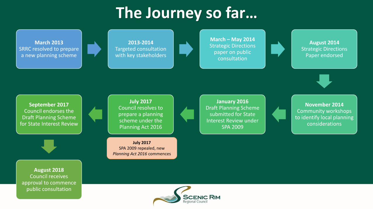
The Journey so far…
March 2013SRRC resolved to prepare a new planning scheme
2013-2014Targeted consultation with key stakeholders
March – May 2014Strategic Directions
paper on public consultation
August 2014Strategic Directions
Paper endorsed
November 2014Community workshops
to identify local planning considerations
January 2016Draft Planning Scheme
submitted for State Interest Review under
SPA 2009
July 2017Council resolves to prepare a planning scheme under the Planning Act 2016
September 2017Council endorses the
Draft Planning Scheme for State Interest Review
August 2018Council receives
approval to commence public consultation
July 2017SPA 2009 repealed, new
Planning Act 2016 commences
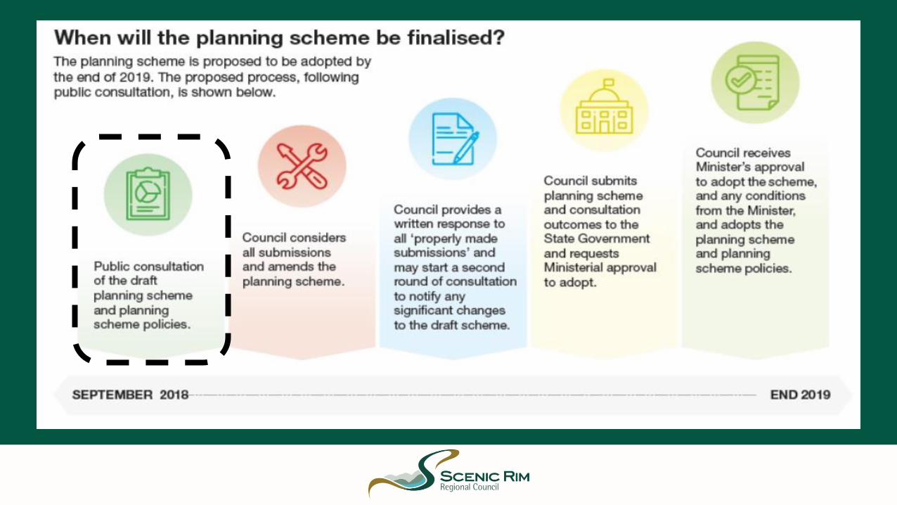
Timeframes / Process
WHAT IS A PLANNING SCHEME?

PLANNING SCHEMES Regulates how land can be used and
developed
Prescribes when a development application is
‘accepted’ (exempt) or
assessable development and required to be submitted
to Council
Help Council plan for infrastructure
to support future growth
Outline the vision for the
local government area and
sets the policy direction and strategic intent for
the region
Sets the assessment benchmarks (criteria)
which development must be assessed against
Identifies the land use zones, precincts and
overlays applicable to
every property

Regulate the way land, buildings and structures are used
Outline the vision for land use and development in the
region
Manage and guide future growth
Plan for Infrastructure to support the community
Identify areas and places to be protected
State when a development application is required and the
Category of Assessment
Outline the desired standards for new development
(building heights, car parking, noise levels, landscaping,
minimum lot size)
× Change or remove existing development that
has been lawfully created
× Deal with matters that are not development
related (animal registration, overgrown
allotments, boundary fences, social gatherings)
× Change the requirements, decisions or decision
making processes of the State Government
× Conflict with the Regional Plan or the State
Planning Policy
What can planning schemes do?

Key Components of a Planning
Scheme
• State Planning Provisions
• Strategic Framework
• Local Government Infrastructure Plan
• Tables of Assessment
• Zones
• Overlays
• Development Codes
• Other Plans (Bromelton State Development Area)
• Definitions
• Maps
• Designated Premises for development of Infrastructure
• Planning Scheme Policies

ZonesEvery property in the region is mapped and included within a Zone.
The zones prescribe the purpose, intent and type of development envisaged for that area.
Zones can also contain zone precincts which outline specific planning outcomes for geographic locations (e.g. Commercial Industrial Precinct)

OverlaysOverlays reflect state and local level interests and identify:
- Areas that are sensitive to development
- Constrained land
- Valuable resources
- Opportunities for development
Overlays can affect where or what type of development occurs on a property and can elevate the assessment or development requirements.

Tables of AssessmentThe planning scheme identifies the category of assessment for development proposals. The category of assessmentcan vary, depending on:
The category of assessment means
the way the application will be
assessed.
Important to know if your proposed development requires Town Planning Approval!
The type of development; (Reconfiguring a Lot, Material Change of Use, Operational Works, Building Works)
the definition of the use proposed;(Office, Shopping Centre, High Impact Industry)
The zone the site is located; OR(Rural Zone, Centre Zone, Low Density Residential Zone)
The overlays mapped over the site.(Flood Hazard Overlay, Landslide and Slope Stability Hazard Overlay)

Category of Development / Assessment
Prohibited Development
Assessable Development
Accepted Development
Accepted (with requirements)must comply with specific criteria
Accepted (exempt)No Development
application required
Code Assessable
• An application that assessed against the applicable codes of the planning scheme.
• Does not require public notification.
Impact Assessable
• An application that is assessed against the whole planning scheme
• Requires Public Notification
A Development Application may not be made and only the Planning Regulation can prohibit development.
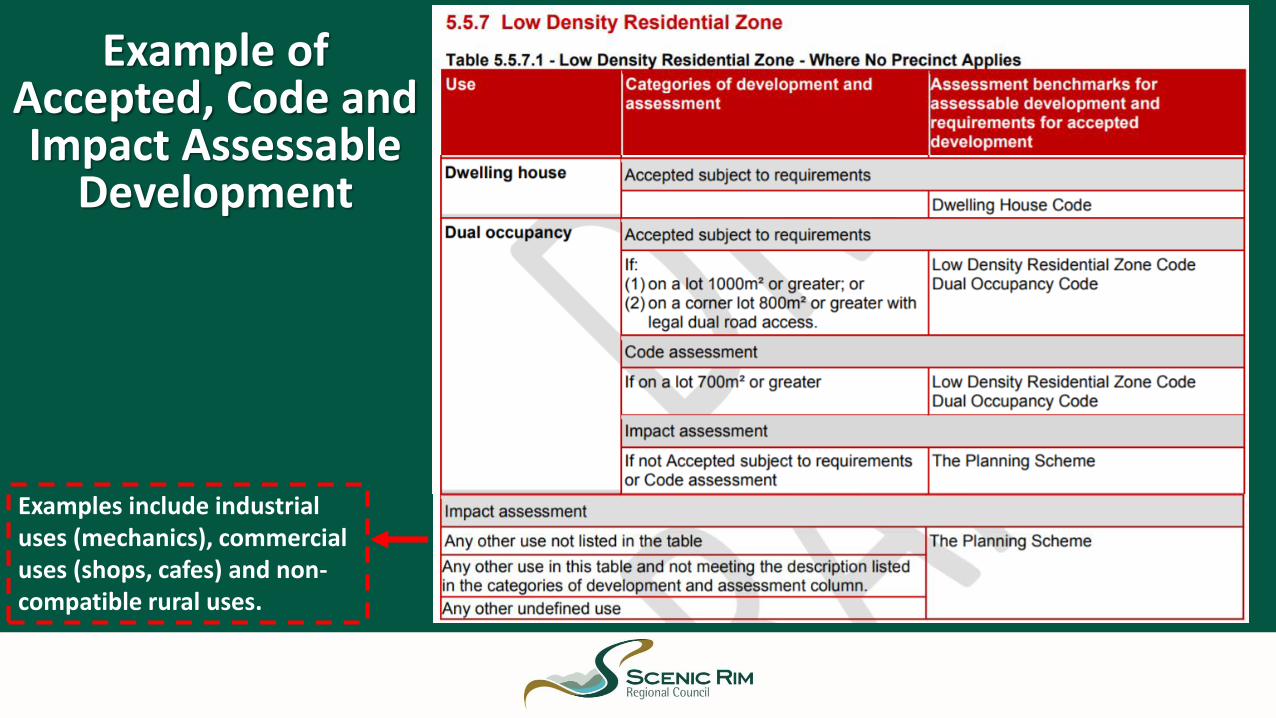
Example of Accepted, Code and Impact Assessable
Development
Examples include industrial uses (mechanics), commercial uses (shops, cafes) and non-compatible rural uses.
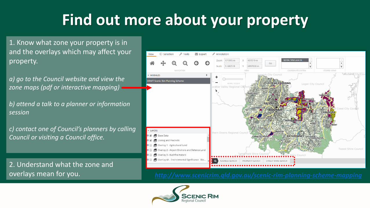
Find out more about your property1. Know what zone your property is in and the overlays which may affect your property.
a) go to the Council website and view the zone maps (pdf or interactive mapping)
b) attend a talk to a planner or information session
c) contact one of Council’s planners by calling Council or visiting a Council office.
2. Understand what the zone and overlays mean for you. http://www.scenicrim.qld.gov.au/scenic-rim-planning-scheme-mapping

Draft Scenic Rim Planning
Scheme

Add map of the region
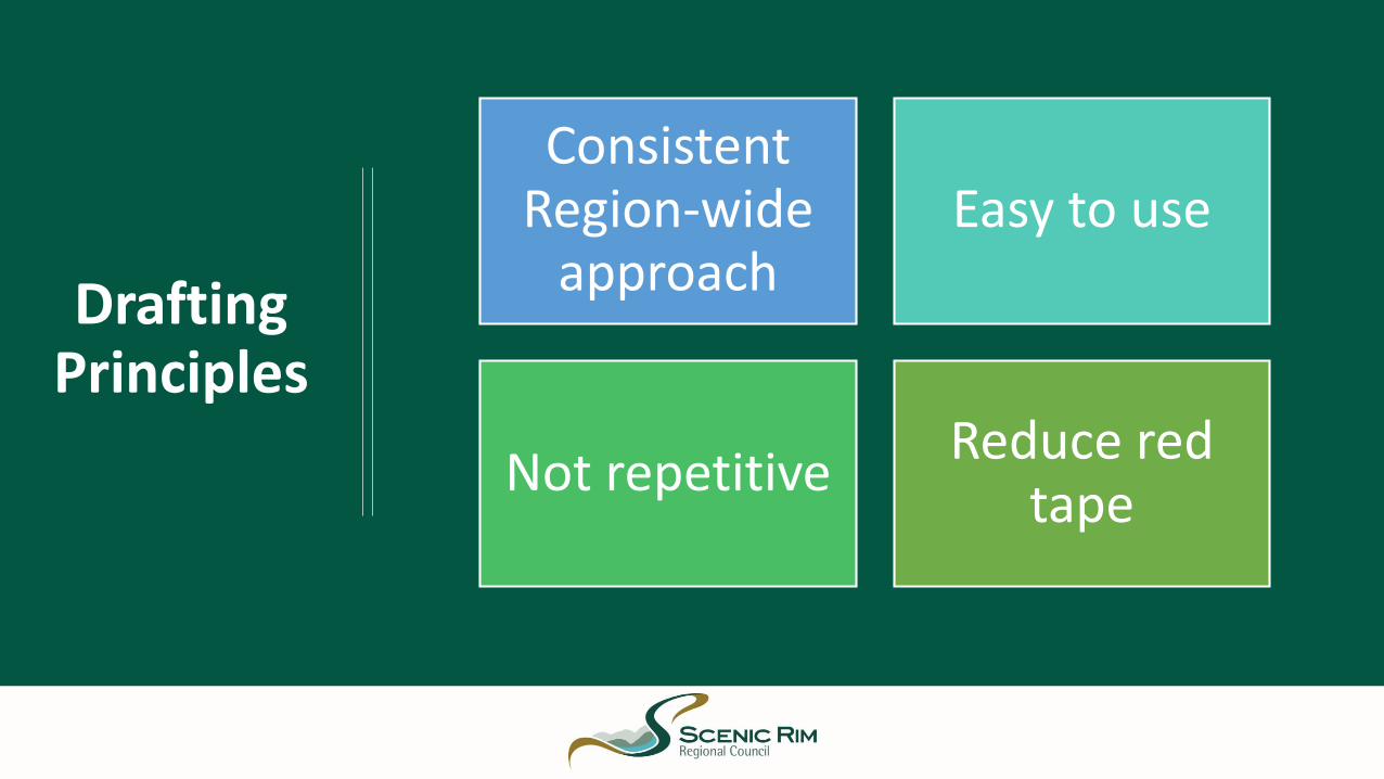
Drafting Principles
Consistent Region-wide
approachEasy to use
Not repetitiveReduce red
tape
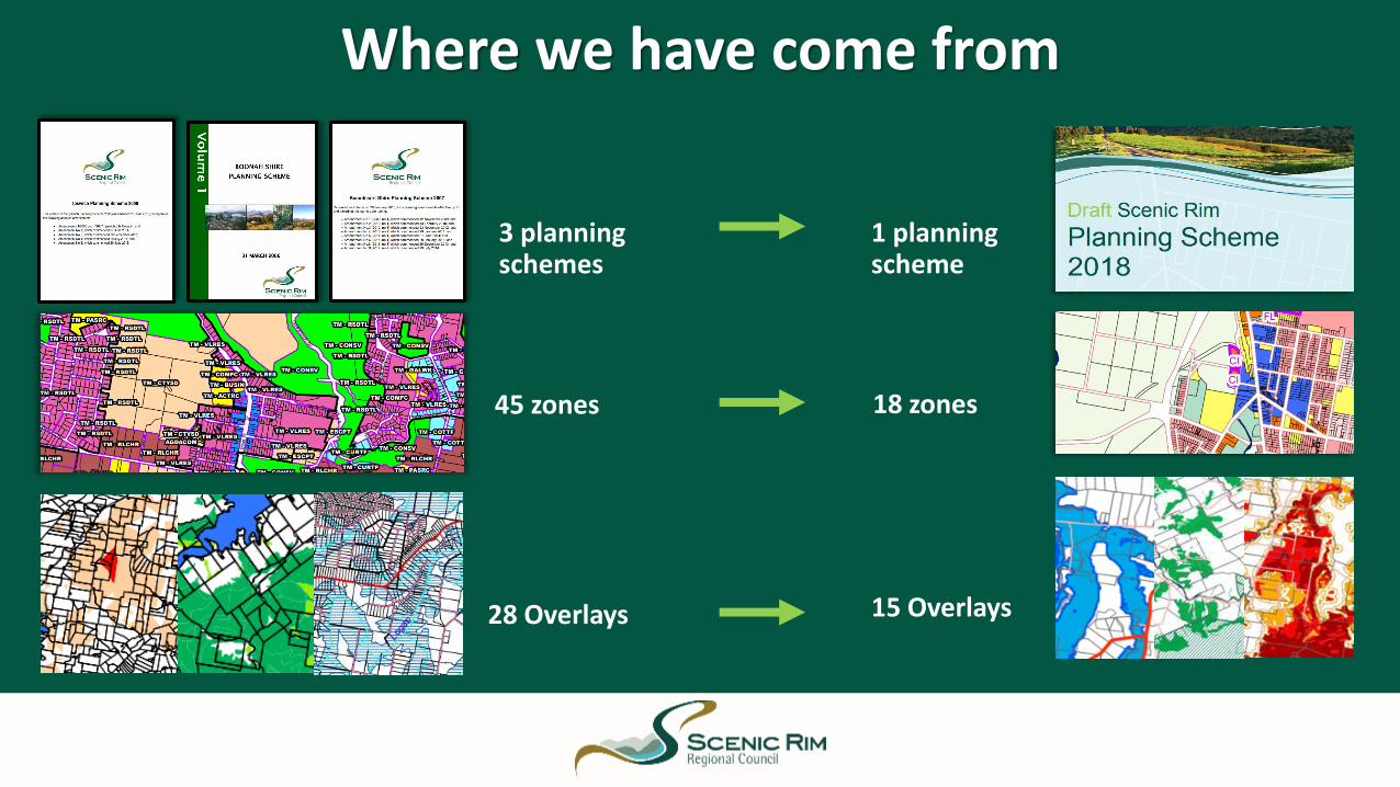
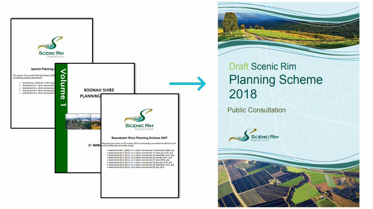
Where we have come from
45 zones
3 planning schemes
28 Overlays
18 zones
1 planning scheme
15 Overlays
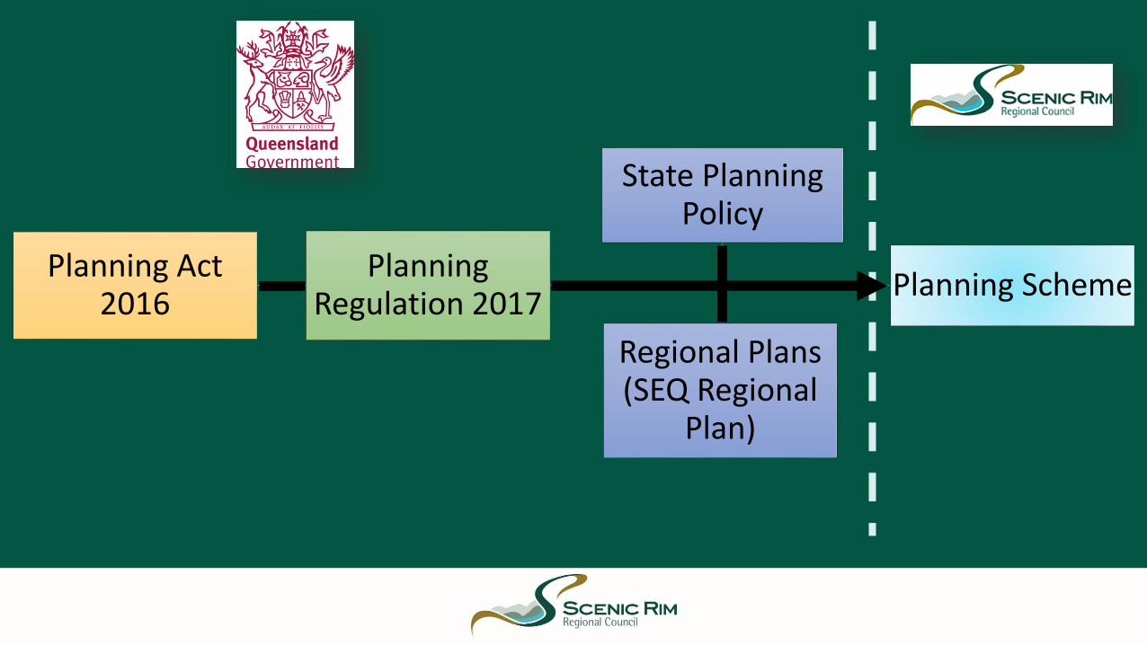
Planning Act 2016
Planning Regulation 2017
Planning Scheme
State Planning Policy
Regional Plans (SEQ Regional
Plan)
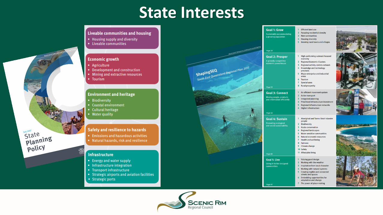
State Interests

KEY REGION WIDE POLICY

Strategic Vision
Retain the lifestyles of the diverse urban, rural,
acreage, townships and mountain communities
Maintain rural production and
protect the region's natural assets and
rural amenity
Protect and enhance the natural
beauty, environment,
natural resources and rural landscapes
Retain and strengthen the
heritage character and community
pride
Provide a range of additional housing
options
Facilitate local employment, better
services and infrastructure and promote economic
development opportunities
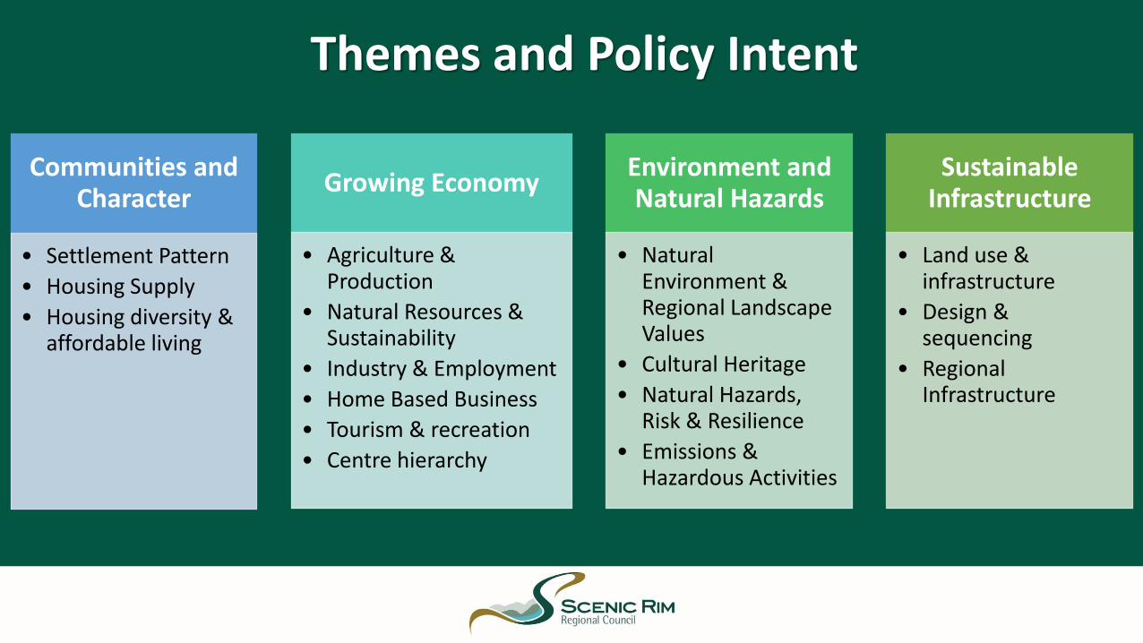
Themes and Policy Intent
Communities and Character
• Settlement Pattern
• Housing Supply
• Housing diversity & affordable living
Growing Economy
• Agriculture & Production
• Natural Resources & Sustainability
• Industry & Employment
• Home Based Business
• Tourism & recreation
• Centre hierarchy
Environment and Natural Hazards
• Natural Environment & Regional Landscape Values
• Cultural Heritage
• Natural Hazards, Risk & Resilience
• Emissions & Hazardous Activities
Sustainable Infrastructure
• Land use & infrastructure
• Design & sequencing
• Regional Infrastructure
Snapshot of key planning scheme policy
for TamborineMountain

Tamborine Mountain in the Future
Tamborine Canungra Statistical Area (SA2) population by 2036: 15,950
(currently approx. 14,689 (QGSO, 2015)
Scenic Rim Local Government population by 2036: 63,000
(currently approx. 41,000) (QGSO, 2015)

Tamborine Mountain – Extract of Strategic Vision
• is sustained by a district centre and two neighbourhood centres that provide for a wide range of local services;
• mix of rural production, tourism and rural enterprise opportunities of a scale and intensity consistent with the area's semi-rural and natural landscape setting and character;
• limited additional low-density acreage lots through the consolidation of the existing rural residential development pattern whilst conserving the landscape and natural values of the area;
• ecological and landscape values conserved and enhanced.
28
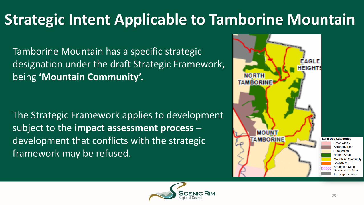
Strategic Intent Applicable to Tamborine Mountain
29
Tamborine Mountain has a specific strategic designation under the draft Strategic Framework, being ‘Mountain Community’.
The Strategic Framework applies to development subject to the impact assessment process –development that conflicts with the strategic framework may be refused.

Zones Proposed for Tamborine Mountain
30

Where in the Rural Residential Zone, limited subdivision opportunities will be permitted only where consistent with the minimum lot size and dimensions (i.e. lot width, access width) shown on the Minimum .
Minimum Rural residential lot sizes:• Where in the Rural Residential A Precinct: 1 hectare• Otherwise: 3,000m²
No additional lots are proposed for land on Tamborine Mountain contained in the Low Density Residential Zone.
The minimum lot size and dimensions are upheld as policyin the Strategic Framework.
Subdivision on Tamborine Mountain
31
Minimum Lot Size Overlay Map for the
Rural Residential Zone

Tourism in Tamborine Mountain
Minor Tourism Zoned areas at Tamborine Mountain facilitate the establishment and ongoing operation of small-scale tourist hubs.
A mix of rural tourism opportunities will continue to be facilitated where they are of a scale and intensity consistent with the area's existing semi-rural and natural landscape setting.
Opportunities for small-scale tourism opportunities outside of these zoned areas may be supported where:
• consistent with the existing natural environment;
• landscape setting and character of the areas; and
• located on appropriately sized properties to avoid impacts on the residential amenity and privacy of nearby properties.
32

Commercial groundwater extraction
Groundwater extraction for commercial purposes is notsupported in the Mountain Community.
• The activity detracts from the amenity of thesensitive residential and nature-based tourismareas;
• The volume of heavy vehicle traffic generated bythe use is inconsistent with the amenity andcharacter expectations of the area.
33
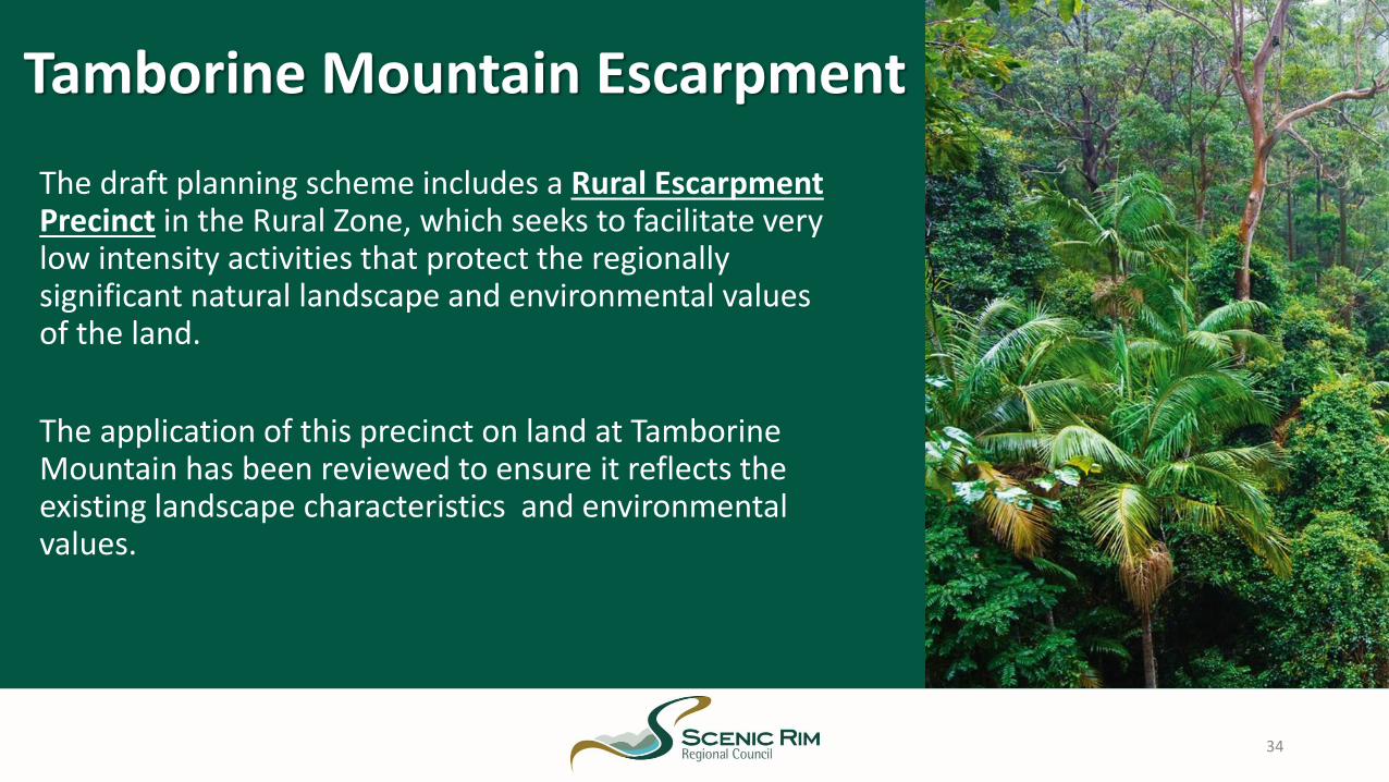
Tamborine Mountain Escarpment
The draft planning scheme includes a Rural Escarpment Precinct in the Rural Zone, which seeks to facilitate very low intensity activities that protect the regionally significant natural landscape and environmental values of the land.
The application of this precinct on land at TamborineMountain has been reviewed to ensure it reflects the existing landscape characteristics and environmental values.
34

OverlaysThe draft planning scheme has taken a region-wide approach to the development of the overlays in the planning scheme. The overlays reflecting constraints or opportunities that apply to Tamborine Mountain are:
• Airport Environs and Defence Land
• Bushfire Hazard
• Environmental Significance (Matters of State Environmental Significance and Matters of Local Environmental Significance)
• Landslide Hazard and Steep Slope
• Local Heritage
• Regional Infrastructure (33kv transmission line)
• Minimum Lot Size
• Transport Noise Corridor
35

Applying the Draft Environmental Significance Overlay to Tamborine Mountain
36
The draft Environmental Significance Overlay applies a region-wide approach across the Scenic Rim in seeking to protect mapped Matters of Environmental Significance. The Matters of Environmental Significance include:
• Protected Areas;• Regulated Vegetation;• State Significant Species;• High Ecological Value Waters (Watercourse and Wetland);• High Ecological Significance Wetlands;• Local Biodiversity;• Koala Habitat;• Local Watercourses (and buffer areas).

Snapshot of key planning scheme policy
for Tamborine

Subdivision of rural zoned land which results in lots less than 100ha in area is not supported.
This provision is set by the State Government within the SEQ Regional Plan.
Settlement Pattern in Tamborine
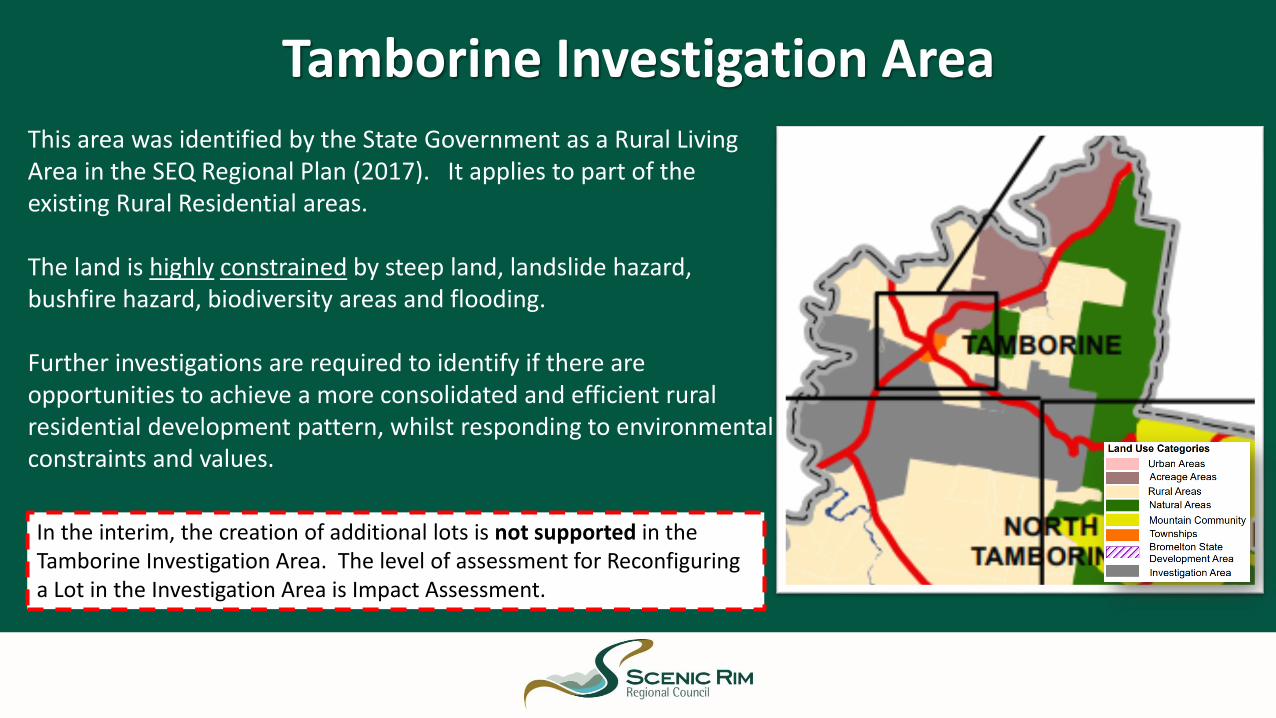
Tamborine Investigation AreaThis area was identified by the State Government as a Rural Living Area in the SEQ Regional Plan (2017). It applies to part of the existing Rural Residential areas.
The land is highly constrained by steep land, landslide hazard, bushfire hazard, biodiversity areas and flooding.
Further investigations are required to identify if there are opportunities to achieve a more consolidated and efficient rural residential development pattern, whilst responding to environmental constraints and values.
In the interim, the creation of additional lots is not supported in the Tamborine Investigation Area. The level of assessment for Reconfiguring a Lot in the Investigation Area is Impact Assessment.

Lodging a Submission

be in writing and signed by each person making the submission
(if the submission is not
lodged electronically)
state the name and residential or business address of each person
making the submission
be received on or before
4:30pm Friday 14 December 2018
state the grounds of the
submission and facts and
circumstances relied on in
support of these grounds
state one postal or electronic address for service relating to the submission for all submission
makers
When preparing a submission, ensure it meets the statutory requirements, to be considered a properly madesubmission:
Have your say
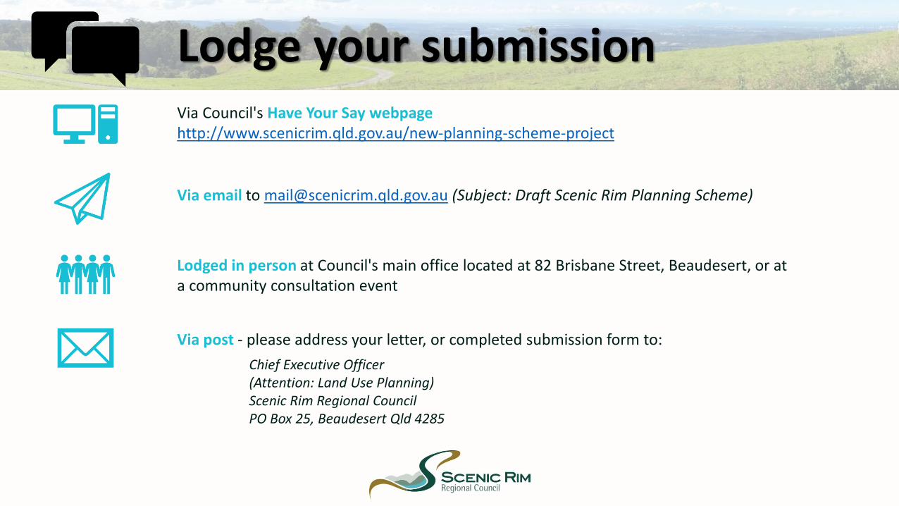
Via post - please address your letter, or completed submission form to:
Via Council's Have Your Say webpagehttp://www.scenicrim.qld.gov.au/new-planning-scheme-project
Via email to [email protected] (Subject: Draft Scenic Rim Planning Scheme)
Lodged in person at Council's main office located at 82 Brisbane Street, Beaudesert, or at a community consultation event
Lodge your submission
Chief Executive Officer (Attention: Land Use Planning)Scenic Rim Regional CouncilPO Box 25, Beaudesert Qld 4285

Information Sheets
• How to make a submission• How to read the Draft Planning Scheme• Draft Planning Scheme Levels of Assessment• Zoning of the Draft Planning Scheme• Overlays of the Draft Planning Scheme• Planning for the risk of Riverine flooding in the Region• Planning for the risk of Bushfire hazard in the region• Planning for the risk of Landslide hazard and Steep Slope in
the Region• Advertising devices
• Domestic Sheds• Dual Occupancy• Dwelling Houses and Secondary Dwellings• Home Based Business• Markets• Pets and Animals• Keeping of Poultry• Protecting Agricultural Land• Roadside Stall• Tamborine Rural Living Area

Thank you!
Council Officers are available to answer questions and discuss the Draft Planning Scheme.


