41


Contact Details:
Web site: www.elmbridge.gov.uk/planningEmail: [email protected]: 01372 474787Address: Planning Services
Planning PolicyElmbridge Borough CouncilCivic CentreHigh StreetEsherSurreyKT10 9SD
elm
bri
dg
e

Summary
What is this consultation all about?
“Early and meaningful engagement and collaboration with neighbourhoods, localorganisations and businesses is essential. A wide section of the community should beproactively engaged, so that local plans, as far as possible, reflect a collective visionand a set of agreed priorities for the sustainable development of an area”
Paragraph 155- National Planning Policy Framework
There have been many changes to the planning system over recent years. TheGovernment is now promoting the production of a Local Plan, a single document thatdeals with all matters relating to the management and planning of development.However, Local Authorities do have the option to develop their Local Plan through aseries of separate related documents. Given that the Council’s Core Strategy is up todate, compatible with the Government’s planning framework 1 , and has its own locallyassessed housing requirement, continuing to develop the Local Plan as a portfolio ofdocuments is the most sensible way forward. In completing our Local Plan portfolio wewant to work closely with the community in order to reflect local needs and aspirationsas far as possible, with the aim of providing clarity and certainty for those who wish todevelop within the Borough. The delivery of our strategy will only be successful if weengage with all those who are affected by new development, infrastructure andservices, and all those who provide it. The Council is committed to taking a strongleadership role, co-ordinating skills, resources and knowledge. We will adopt aproactive approach to the planning and management of development in order to ensurethat the aims of the Core Strategy are delivered where, when and how we intend.
The aim of Settlement Investment and Development (ID) Plans is simply to plan forinvestment and development within local areas in partnership with the local community.Elmbridge has 8 distinct settlements, which have very different characters andcommunities. Recognising these differences, and working together, drawing on theopportunities that arise and addressing the challenges that new development maybring, is key to maintaining local choice, control and ownership. It is the Council’s viewthat to ‘do nothing’ and sit back and wait for development to happen is a poor way toplan for the future of the Borough. Settlement ‘ID’ Plans will make a significantcontribution to the delivery and management of development that provides for the levelof growth set out in the Core Strategy, supported by improved infrastructure andservices.
1.[National Planning Policy Framework (NPPF)]
elm
brid
ge

How you can tell us your views
Settlement ID Plans identify;
• Open spaces that need to be protected and some earmarked for enhancement• Employment land that should remain as such because of its strategic
importance• Schools and colleges where there are opportunities for expansion• Key sites for the delivery of housing, commercial and community development• Pitches for Gypsies and Travellers• Infrastructure improvements and priorities
This document is for consultation purposes only. The Council has already directed asignificant amount of resources into holding workshops with the local community,landowners, businesses and potential developers. They have provided useful forums toopenly discuss needs, aspirations and intentions, but these were just the start of theprocess. The document presented here is for wider consultation. The aim is that thefinal version of the plans will truly reflect local aspirations, while acknowledging thatlandowners and developers are key to delivery.
We are consulting on this document for a 6-week period between 8 April 2013and 20 May 2013. Please let us know what you like, what you don’t like, and whereimprovements can be made. Changes are inevitable and we hope that consultationresponses can add a greater element of local distinctiveness to each plan.
Within this period, planning officers will be visiting your local area, giving you moreopportunity to provide input, and influence future development and infrastructureprovision. Visit our web site to see when we will be in your area. We strongly encourageyou to use our new on line consultation portal. This is easy to use and the most efficientway of dealing with comments. Log on to our website and, if you need help, justtelephone the number below and we will be happy to assist.
Web site: www.elmbridge.gov.uk/planningEmail: [email protected]: 01372 474787Address: Planning Services
Planning PolicyElmbridge Borough CouncilCivic CentreHigh StreetEsherSurreyKT10 9SD
elm
bri
dg
e

What are we planning to do next?
Once we have received your comments, we will give consideration to all of them anddecide what changes should be made in order to better reflect the views of thecommunity whilst being mindful that we do need to plan for growth and be realisticabout delivery.
You will be able to see what difference your comments have made in the ConsultationStatement which will set out how and why the comments made during the consultationhave either been taken on board and influenced the final document, or have not beenconsidered appropriate for inclusion. The Consultation Statement will be available onthe Council’s website.
If significant changes are considered necessary, either due to the nature of responsesor the submission of new information, we will re-consult and everyone will have afurther opportunity to comment. In the event that only minor changes are necessary, theplans will be submitted to the Secretary of State for examination by an independentinspector in the att the start of 2014. At this point, you still have an opportunity tocomment on the plans if you so wish. However, it is hoped that by adopting acollaborative approach to drawing up these plans, they will benefit from a significantamount of support from the local community and objections will be kept to a minimum.
Stage in process Date Re-consultation necessary(alternative dates)
Publication November 2013 Summer 2014Publication for independentexamination
December 2013 Autumn 2014
Adoption Autumn 2014 End of 2014
elm
brid
ge

Table of Contents1 Introduction ...................................................................................................... 1
The Planning Strategy for Elmbridge ..................................................... 1Progress so far ....................................................................................... 1Supporting new development that's right for local areas ........................ 3Why is it good to have a plan? ............................................................... 4What if you don't like the plan for your area? ......................................... 4What will Settlement ID Plans do? ......................................................... 5Protecting land for existing uses ............................................................ 5Promoting the right development in the right places .............................. 7Investing in infrastructure ....................................................................... 9Local Plans for local communities ........................................................ 10
2 East and West Molesey Development Plan .................................................. 12About the area ...................................................................................... 12The Core Strategy ................................................................................ 13Purpose of this ID plan ......................................................................... 13What does the East and West Molesey ID Plan propose? ................... 14What you have told us so far ................................................................ 15
3 Sites to be protected ..................................................................................... 18Open Space ......................................................................................... 18Strategic Employment Land ................................................................. 20
4 Potential development sites .......................................................................... 23Opportunity sites .................................................................................. 25Other Possible Sites ............................................................................. 31Sites with Planning Permission ............................................................ 32
5 Priorities for investment ................................................................................. 33Education ............................................................................................. 33Transport and Highways improvements ............................................... 34Other infrastructure .............................................................................. 35Workshop feedback .............................................................................. 35
elm
bri
dg
e

1 Introduction
The Planning Strategy for Elmbridge
Progress so far
1.1 The Elmbridge Core Strategy, adopted in July 2011, sets the overarchingstrategy for the Borough. It adopts a local approach to the promotion of sustainablegrowth, directing the right sort of development to the right places, whilst protecting theenvironment and providing community infrastructure.
1.2 In considering the soundness of this planning strategy, the independentplanning inspector wrote;
“In terms of housing, employment and other development, the plan provides for growth,reflecting the Government’s agenda, and generally it strikes the right balance betweenneeds and demands”.
‘In its approach to the Green Belt the plan is also consistent with the Government’sPlanning for growth agenda. This makes clear that wherever possible the answer toproposals should be yes, while ensuring the key sustainable development principles setout in national policy would not be compromised’
1.3 Since the adoption of the Core Strategy, the Government has published a newplanning framework. The Council considers that its Core Strategy is compatible withthis planning framework.2
1.4 However, the Core Strategy forms only part of the Elmbridge Local Plan and acommitment has been made to prepare further documents to direct and shape futuregrowth. The diagram overleaf illustrates the family of documents that will make up theCouncil’s Local Plan and how they relate to each other.
1.5 In response to local concerns about the impact of new development on localcharacter and infrastructure, the Council prioritised the production of two documentswhich were adopted in April 2012;
• Design and Character Supplementary Planning Document• Developer Contributions Supplementary Planning Document.
1.6 In addition, a Community Infrastructure Levy Charging Schedule, the first inSurrey, which was adopted in April 20133 . This sets a charge of £125 per square metrefor new residential development and £50 per square metre for retail development. The
2.[The compatibility checklist can be found at www.elmbridge.gov.uk/planning]
1
elm
brid
ge

aim is to provide clarity about expectations prior to buying land, and ensure that newdevelopment contributes to the creation of an environment where growth is not stifledthrough lack of infrastructure and investment. It is estimated that this charge will raise inthe region of £24 million over a 10 year period which will go towards funding acomprehensive package of infrastructure improvements across the Borough.
1.7 The Council is now producing the remaining documents that will complete itsLocal Plan;
• The Development Management Plan• Settlement ID (Investment and Development) Plans
1.8 These two documents are being produced concurrently and are both subject toconsultation now.
3.[CIL is a new levy that will be charged on new developments.The money raised can be pooled and used tofund infrastructure that the councill and the local community wants - for example, new or safer road schemes,school expansion or improvements to leisure facilities.Further details of CIL including a summary can befound on the Communities and Local Government website and the Council’s website www.elmbridge.gov.uk/planning ]
2
elm
bri
dg
e

Supporting new development that's right for local areas
1.9 The Council will adopt a positive approach to the consideration of developmentproposals. We will work with the local community as well as developers to findsolutions, which means that appropriate sites will be allocated for developmentwherever possible, in order to provide a clear and coherent plan that improves theeconomic, social and environmental conditions of the Borough. Whilst promoting theright sort of development in the right places, we are committed to making sure that the
3
elm
brid
ge

Why is it good to have a plan?
What if you don't like the plan for your area?
key sustainable development principles set out in the Government’s planningframework are not compromised.
1.10 With or without a plan, development will happen anyway. Adopting a plan ledapproach allows the Council to take a strong leadership role that will steer developmentwithin the Borough, protecting valued open spaces, directing investment in improvedinfrastructure where it is needed most, and delivering development of a type and withinlocations that are considered to be most appropriate. Such an approach means that theCouncil has to make difficult decisions, but it allows us to manage and plan fordevelopment, taking account of the potential impact on local areas.
1.11 The Core Strategy commits to the delivery of approximately 3,375 new homesbetween 2011- 2026. This equates to 225 units each year. In the first 2 years, weanticipate that 550 units will have been completed , 100 above the requirement. Whilstthis puts the Council in a strong position with regards to retaining decision making at alocal level, this supply needs to continue, and in a manner that the Council chooses,rather than decisions being made by the Planning Inspectorate or the Secretary ofState.
1.12 By taking a proactive approach the Council can plan ahead, ensuring that theright infrastructure comes forward at the right time. Only through the identification ofwhere and how growth is likely to happen can effective infrastructure planning takeplace.
1.13 ID Plans, prepared for each of the 8 individual settlements within Elmbridge,will make a significant contribution to supporting the delivery and management ofdevelopment that;
• Protects land from development where appropriate,• Provides the required level of growth set out in the Core Strategy, and• Improves infrastructure and services to support this growth.
1.14 Through encouraging the local community to take part in this process, it ishoped that these Settlement ID Plans, will reflect local opinion as far as possible. Wewill do all that we can to take on board your views but we are duty bound to plan withinthe context of the Government’s wider growth agenda. We think our approach willachieve the best results for local communities, achieving the right blend of localknowledge and professional expertise. Nevertheless, there are alternatives.
1.15 Tell us. Nothing is set in stone but we do have to start somewhere, and if wedon't ask we won't know. However, if you really want to take control and make the
4
elm
bri
dg
e

What will Settlement ID Plans do?
Protecting land for existing uses
Open Spaces
decisions yourself, you can. Local communities do have the option of preparing theirown neighbourhood plans. These can set planning policies to determine decisions onplanning applications, but they do need to be prepared in the overall context of the CoreStrategy and the Government’s planning framework.
1.16 Importantly, neighbourhood plans cannot be used to restrictdevelopment. They can steer development and set out plans for moredevelopment than set out in the Core Strategy but not less.
1.17 Whilst there have been some expressions of interest by local communitygroups, no proposals for a neighbourhood plan have been progressed. This doesremain an option should community groups decide they wish to prepare their own localneighbourhood plan for growth.
1.18 Another alternative is to sit back and wait for development to come, notknowing where, when or how much - a sure way to create uncertainty and ‘lag’ withregards to infrastructure provision. It is an alternative that avoids making difficultdecisions but fails to plan properly for the future of our local areas. As a responsibleCouncil, we will make the difficult decisions and plan for the future.
1.19 The Settlement ID Plans have 3 distinct roles;
i. Protecting sites in their current use –these are designated to ensure that theyare not lost to other uses.
ii. Identifying key sites for new development – these are allocated and will act asa framework within which the Council can plan and manage growth in the future
iii. Assessing infrastructure needs- these will need to be prioritised in line with thedelivery of new development in an area, together with an assessment of itsimpact and the aspirations of the local community.
1.20 Each ID Plan will differ dependant on its local character, the capacity ofexisting infrastructure to accommodate growth and the opportunities available for newdevelopment and environmental enhancement.
1.21 Overall, open spaces within the urban area will be given greater protectionthan before through Development Management policy- DM5.4 This sets out that existingopen spaces should not be built on unless:
4.[The Council’s Draft Development Management is also being consulted on at the moment. Please visit ourweb site to take part in this consultation and consider the new policies we propose to protect our open spaces]
5
elm
brid
ge

Employment land
- “An assessment has been undertaken which has clearly shown the open space,buildings or land to be surplus to requirements; or
- The loss resulting from the proposed development would be replaced by equivalent orbetter provision in terms of quantity and quality in a suitable location; or
- The development is for alternative sports or recreational provision the needs of whichclearly outweigh the loss”.
1.22 In addition the Government’s planning framework5 sets out an additionalprotection that can be given to green spaces of particular importance to localcommunities. These can be designated as ‘Local Green Space’ and will benefit fromthe same level of protection as Green Belt. However, in considering the designation ofLocal Green Space, the framework states that:
“The Local Green Space designation will not be appropriate for most green areas oropen space. The designation should only be used:
- Where the green space is in reasonably close proximity to the community it serves;
- Where the green area is demonstrably special to the local community and holds aparticular local significance, for example because of its beauty, historic significance,recreational value (including as a playing field), tranquillity or richness of its wildlife; and
- Where the green area concerned is local in character and is not an extensive tract ofland”
1.23 As open space is afforded a higher level of protection than has previously beenthe case it is considered that the existing Strategic Open Urban Land designation is nolonger relevant.
1.24 In line with Core Strategy policy CS23 Employment Land Provision, thedesignation of Strategic Employment Land will seek to ensure an adequate, yet flexible,supply of employment land. In considering the designation of sites, paragraph 22 of theNational Planning Policy Framework needs to be taken into account;
“Planning policies should avoid the long-term protection of sites allocated foremployment use where there is no reasonable prospect of a site being used for thatpurpose. Land allocations should be regularly reviewed. When there is no reasonableprospect of a site being used for the allocated employment use, applications foralternative uses of land or buildings should be treated on their merits having regard to
5.[Paragraphs 76, 77 and 78 of the National Planning Policy Framework]
6
elm
bri
dg
e

Gypsy and Traveller sites
Promoting the right development in the right places
market signals and the relative need for different land uses to support sustainablecommunities”
1.25 The Council regularly monitors the demand for employment floorspace as wellas employment land projections for the Borough. The need for certain types ofemployment land is changing. Currently, there is a high level of vacant office floorspaceand the need for industrial land is declining. However, we need to take a long-term viewof what we may need in the future and balance this against the need for other uses,specifically the continual demand for housing and in particular affordable housing.
1.26 Careful consideration will need to be given to designating areas as StrategicEmployment Land. The balance needs to be struck between maintaining a sufficientsupply that addresses employment growth projections, whilst ensuring that there is adegree of flexibility when considering the future use of other employment sites. CoreStrategy policy CS23 Employment Land Provision will ensure that sites will continue tobe protected and redevelopment only supported where it can be shown that itsemployment use is redundant and that its change of use will benefit the community.
1.27 Given the above, it is proposed that the number of sites currently designatedas Strategic Employment Land is reduced. Those that are proposed to retain adesignation are considered to be significant to the delivery of economic growth, not onlywithin the Borough, but also across the wider M3 Local Economic Partnership (LEP)area. Factors such as the current use, future demand, levels of employment, size andsub regional impact have been assessed in the consideration of strategic designation.
1.28 Whilst the number of pitches to be provided for Gypsies and Travellers issignificantly lower than the Borough’s overall housing need, suitable sites are oftendifficult to deliver. The ID Plans propose new sites to address the additional need, butthis assumes that existing provision is not lost to alternative uses. As such existing,permanent and legal Gypsy and Traveller sites, as well as Travelling Showpeople sites,have been designated for continued protection.
1.29 Through ID Plans, the Council is encouraging the most effective use of landthrough promoting development on allocated sites and improvements to open spaces.Uses vary but include;
• Housing• New Gypsy and Traveller pitches.• Mixed use sites in town centres• Community, social and education provision
7
elm
brid
ge

How do we judge what is the best use of a site?
• Major open space improvements to provide alternative visitor destinations forpeople who would otherwise visit the Thames Basin Heaths, an area protectedfor its high ecological value.
1.30 Local character, design and density are key factors that need to be taken intoaccount when considering the acceptability of any new development, regardless of itsuse. The Council already has policies in place that aim to make the most effective useof land whilst delivering high quality design that takes account of the different roles andcharacter of different areas across the Borough6 .
1.31 It’s not easy and there are often competing uses for a site that we need toconsider. The allocation process has been developed to ensure that only reasonablealternatives for development will go through to the consultation stage. Reasonablealternatives will be judged against the following criteria which essentially act as a ‘sift’.
1.32 The assessment process has been divided into a number of stages (Figure 1).
• Stage A – Initial Assessment – this eliminates sites that are not in line with theCouncil’s Core Strategy or are considered too small for inclusion.
• Stage B – Deliverability Assessment – eliminates any sites that are notgenuinely developable and available to be delivered.
• Stage C – Detailed Assessment – assesses the social, economic andenvironmental effects of the proposed development (incorporating SustainabilityAppraisal)
Further details can be found at www.elmbridge.gov.uk/planning
1.33 In addition, where a site has been discussed at the local workshops, the levelof community support has been taken into account. In most cases this has influenced
6.[Policy CS17 - Local Character, Density and Design. Elmbridge Core Strategy, July 2011. Design andCharacter Supplementary Planning Document. Elmbridge Local Plan, April 2012. Core planning principles,paragraph 17, National Planning Policy Framework, March 2012]
8
elm
bri
dg
e

Do we really have room for more development?
Is an allocation the same as planning permission?
Investing in infrastructure
whether a site has been put forward as an ‘opportunity site’ or an ‘other possible site’for consultation purposes.
1.34 The intention is not to allocate all sites that could potentially be developed overthe lifetime of the plan. This would be impossible and an approach riddled withuncertainty. Only key sites, of particular significance to the area will be allocated. TheID Plans present a range of site for consultation. The threshold for inclusion differsbetween areas, the minimum being 6 units.
1.35 It is inevitable that some sites will fall out, and others come forward during thelifetime of the plan. The Council’s Strategic Housing and Employment Land AvailabilityAssessment therefore continues to be an important document. Through rigorousmonitoring and annual review of this land availability assessment, the Council willalways have up to date evidence of potential future land supply in order to ensure thedelivery of our overall housing target, and potential capacity for employmentfloorspace.
1.36 Yes we do. The Strategic Housing and Employment Land AvailabilityAssessment provides a key tool to assess potential capacity for all sites above 6 units.This is updated annually. It is designed to reflect, and take account of, the turnover and‘churn’ of sites in the Borough and provide an up to date picture on potential capacity.Importantly, it does not allocate sites for development but acts as a guide to whetherhousing requirements are likely to be met. The Strategic Housing and EmploymentLand Availability Assessment will continue to play an important role in providing aflexible and up to date response to potential housing capacity but it does not representCouncil policy nor does it reflect any views of the local community.
1.37 No it’s not. An allocation in a Settlement ID Plan provides much greatercertainty as to the future development of a site. These sites are all subject to publicconsultation, sustainability appraisal, viability assessment and ultimately, agreement bythe Council. An allocation does not grant planning permission. However, it does showthat the Council agrees with the general principle of development but all proposals willstill be subject to detailed consideration against relevant planning policies should anapplication be submitted.
1.38 New development will inevitability put increasing pressure on existinginfrastructure, so we have made sure that new development ‘pays its way’ through theCommunity Infrastructure Levy.
9
elm
brid
ge

Local Plans for local communities
1.39 Investment in infrastructure will be dependent on;
• Existing commitments by service providers (such as Surrey County Council,Network Rail etc),
• The level of growth within an area and the consequent impact on infrastructure• Priorities identified by the local community.
1.40 The Council has recently appointed an Infrastructure Delivery Officer who willbe responsible for ensuring the timely delivery of infrastructure and producing atransparent spending programme that prioritises the money that will be raised throughthe Community Infrastructure Levy. A key objective of the post is to work closely withother delivery agencies, co-ordinating spend with other spending programmes,including existing funds already collected from developments, and other availablefinance such as the New Homes Bonus7
1.41 Where improvements can be identified, such as the potential expansion of aschool, then these have been included for consultation. However, in many cases it willnot be possible to identify the specific improvement in infrastructure. In these cases, thematter to be dealt with has been identified generically eg. Improvements to tacklecongestion, improvements to open spaces etc. Schemes will then be drawn up as andwhen sufficient finances become available. Local people will be asked to assist insetting spending priorities.
1.42 This Settlement ID Plan sets out a range of potential improvements that couldbe made within the area. Many of the infrastructure needs for the Borough have alreadybeen identified in the Council’s Infrastructure Delivery Plan, prepared in support of theCore Strategy and subsequently updated for the preparation of the CommunityInfrastructure Levy. In addition suggestions put forward in the local workshops havealso been included as appropriate.
1.43 Investment and Development Plans have been produced for the 8 individualsettlements identified within the Core Strategy. They all follow a standard format forinitial consultation with local communities and others that have interests within theBorough. They are based on information that the Council believes to be correct, butinevitably this will change as a consequence of consultation and, of course, thepassage of time. If the information is wrong-please tell us! It is hoped that, throughengaging local communities, each ID Plan will develop in a locally distinctive way thatreflects the wishes of the community. As such, we encourage you to become involvedin the development of these plans.
7.[https://www.gov.uk/government/publications/new-homes-bonus-final-scheme-design--2]
10
elm
bri
dg
e

These Settlement ID Plans are exactly what they say they are-Initial drafts for public consultation.
It is for you to tell us your views so that we can shape them into the documents thatyou would choose in order to plan and manage development within your local area.No decisions have been made at this stage. Consider the options. Are there
any others?
1.44 In doing so, choices must be made within the wider context set out in thisintroduction. They must accord with national planning policy and help to deliver theoverall strategy for the Borough set out in the Core Strategy. Meeting our housingobjectives is key to the Council maintaining local control over decision making. As such,the anticipated level of new housing to be provided within each settlement area isreproduced for convenience below.
Settlement Anticipated housingdistribution
Walton 675-725Weybridge 625-675Hersham 350-400East and West Molesey 475-525Thames Ditton, Long Ditton, Hinchley Wood andWeston Green
375-425
Esher 250-300Cobham, Oxshott, Stoke D'Abernon and Downside 575-625Claygate 50-100
1.45 Whilst delivery may be higher in some areas and lower in others, overalldelivery must at least meet the minimum overall housing target of 3,375 set out in theCore Strategy. Given the market attractiveness of the Borough, coupled with theCouncil’s commitment to retain local control and adopt a sensible approach to planningfor sustainable growth, it is considered that this target will be achieved, and potentiallyexceeded, without resulting in unacceptable consequences on the local environment orthe economic health of the Borough.
The following sections of this Settlement ID Plan sets out the initial draftplans for consultation for your local area.
We would like to hear your views.
11
elm
brid
ge

2 East and West Molesey Development Plan
About the area
2.1 The settlement area of East and West Molesey is in the northeast of theBorough bordering the London Boroughs of Richmond and Kingston, which lie on theopposite side of the River Thames. Its role within the settlement hierarchy is as asuburban settlement area, and whilst it is primarily residential in character there are twosubstantial areas currently designated as Strategic Employment Land – MoleseyIndustrial Estate and Imber Court Trading Estate both of which support a range of lightindustrial, storage, distribution and service industries.
2.2 The general character of the residential area is varied, ranging frompredominantly Victorian houses in the east to 1960s housing in the west. In total thereare 5355 dwellings8 and a population approaching 13,0009 . A particular feature of thearea is the amount of social housing and ex-local authority owned properties in WestMolesey. This area has significantly higher proportions of social housing than otherparts of the Borough containing 18% of all social housing in Elmbridge10 .
2.3 The settlement has 5 individual shopping areas each with distinctly differentroles with regards to the nature of the shops and services they provide. These includea District Centre at East Molesey, a Local Centre at Bridge Road and small parades/local shops at West Molesey, Central Avenue and Pool Road. East Molesey DistrictCentre supports a good range of shops and services (88 units), 48% in retail use. 4%of floorspace is vacant11 Hampton Court Palace is located opposite Bridge Road LocalCentre and has a significant influence on the character and mix of uses in this area.
2.4 The area is almost entirely surrounded by water with the River Thames to thenorth, River Ember to the east, and a series of reservoirs and gravel pits to the westand south. Bridges over the River Thames and Ember form key gateways to the area.
2.5 It contains a number of important open spaces such as Hurst Park, the largestpark in the Borough. These are considered to be a vital part of the urban area providinggreen space in what is a relatively densely developed area.
2.6 Between 2006 and 2011 190 new dwellings were delivered in the settlementarea, of which 26 (14%) were delivered in either a town or village centre. 69% of alldwellings built were flats with 31% houses. The majority of dwellings were 1 or 2bedroom units (70%) and the average densities of completed dwellings during thisperiod was 50 dwellings per hectare 12
8.[Dwelling stock by Council Tax Band (VOA) ]9.[Resident Population Estimates 2010 (ONS) ]
10.[Based on the 2001 census and includes both social rented and shared ownership tenures. Figures will beupdated when 2011 census data becomes available]
11.[Elmbridge Town and Village Centre Audit (2012) ]
12
elm
bri
dg
e
The Core Strategy
Purpose of this ID plan
2.7 The Core Strategy provides the overarching context for the future developmentof the Borough. Policy CS7 sets out a specific strategy for East and West Molesey to2026 and the Settlement Investment and Development Schedules contained inAppendix 2 of the Core Strategy provide an outline of the delivery of development andinvestment expected within the settlement area. In summary the Core Strategy setsout:
• An anticipated level of housing provision in the area between 475 and 525 unitsbetween 2011 and 2026.
• The potential for an additional 11,000 sqm of floorspace on vacant land inMolesey Industrial Estate.
• Capacity to deliver 2000 sqm of additional office floorspace.• 1 to 2 additional forms of entry at primary school level.• A commitment to consider parking issues through a local parking strategy and a
local management plan.• Enhancements to play equipment in local open spaces.
2.8 The Core Strategy makes it clear that the delivery of development andinfrastructure will change over time. Up-to-date information will be included within theCouncil’s Infrastructure Delivery Plan, Authority’s Monitoring Report and StrategicHousing and Employment Land Availability Assessment13 .
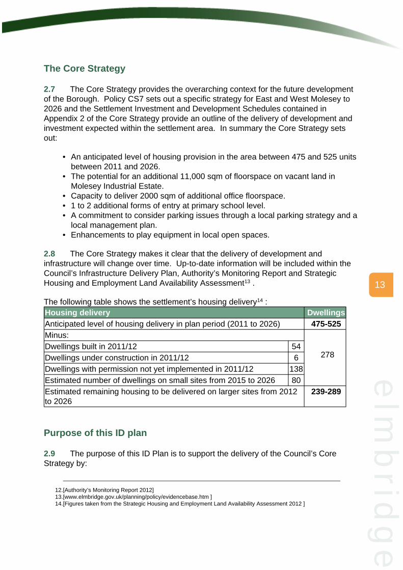
The following table shows the settlement’s housing delivery14 :Housing delivery DwellingsAnticipated level of housing delivery in plan period (2011 to 2026) 475-525Minus:Dwellings built in 2011/12 54Dwellings under construction in 2011/12 6Dwellings with permission not yet implemented in 2011/12 138Estimated number of dwellings on small sites from 2015 to 2026 80
278
Estimated remaining housing to be delivered on larger sites from 2012to 2026
239-289
2.9 The purpose of this ID Plan is to support the delivery of the Council’s CoreStrategy by:
12.[Authority’s Monitoring Report 2012]13.[www.elmbridge.gov.uk/planning/policy/evidencebase.htm ]14.[Figures taken from the Strategic Housing and Employment Land Availability Assessment 2012 ]
13
elm
brid
ge

What does the East and West Molesey ID Plan propose?
• Allocating key sites with potential for development in the urban area in order todeliver the requirement set out within the Core Strategy and enable thecontinued protection of the Borough’s Green Belt and urban open spaces. Thisincludes employment land, housing, mixed use and gypsy and traveller pitches.
• Designating open space within the urban area for continued protection.• Reviewing the designation of Strategic Employment Land.• Identifying priorities for future investment in infrastructure e.g. schools,
transport, highways etc.
2.10 The ID Plan for East and West Molesey includes the following proposals forconsultation:
• 8 sites that may have potential to be allocated for development.• 26 areas of urban open space for designation as well as 4 areas of Local Green
Space• Strategic Employment Land at Molesey Industrial Estate for long-term protection
and removal of this designation at Imber Court.• 3 school sites where there is potential for future expansion to accommodate an
increase in pupil numbers including options to deliver a new school.• Priorities for investment in other forms on infrastructure including schools,
transport, highways etc.
2.11 The map below gives an overview of the potential development sites to beallocated and open spaces and Strategic Employment Land to be designated.Sections 3-5 set out these in further detail.
14
elm
bri
dg
e

What you have told us so far
2.12 In August 2012 we held a ‘Managing Development’ workshop at Mole Hall,West Molesey. This was a key part of our early engagement to inform the preparationof the ID Plan for East and West Molesey. The workshop was attended by a widerange of organisations and individuals including representatives from the localcommunity, landowners, agents etc. This provided an excellent forum for discussionand debate and highlighted areas of both agreement and disagreement between thoseattending.
15
elm
brid
ge

2.13 This was the first stage of engagement in the preparation of the ID Plan andprovides a snapshot of views from those people who attended the workshop. It doesnot represent views across the whole community but provides a starting point for thepreparation of the Plan and future engagement.
2.14 The key issues discussed at the workshop included15 :
Sites to be protected:
• The importance of retaining green spaces due to the relatively high densitiesfound in the area. In particular open spaces with an existing designation shouldcontinue to be protected.
• Maintaining existing Strategic Employment Land at Molesey Industrial Estatewas considered to be important.
• Some suggested the protection of the Former Sewage Works16 site as an openspace or including it within the Green Belt. The site is currently allocated forresidential development.
Potential development sites:
• Many of those attending expressed concern that Molesey had been overdeveloped in the past and cannot take much more development.
• The potential redevelopment of Imber Court Trading Estate was discussed -there was a mixed response with regard to maintaining Imber Court TradingEstate as Strategic Employment Land. Some felt it would be appropriate toredevelop the site for housing should the site be brought forward.
• Residential development on the former John Nightingale School site wasdiscussed. There was a mixed response from those attending which reflectedconcerns that the majority of people had regarding further residentialdevelopment in the area. Other proposals for the site included a new greenspace or an education use, either primary or secondary.
• Some considered the former Molesey Sewage Works site to be suitable forresidential development or Gypsy and Traveller pitches.
Priorities for investment
• The potential for developing some community assets, such as Mole Hall, forhousing was raised but it was stressed that the Council would need to ensurethat there are still sufficient high quality community spaces within the area.
• It was considered that there was a need for increases in school places withsome of those attending proposing that a secondary school in Molesey.
• The impact of development on congestion in the area was a concern and theneed to improve road safety and support other modes of transport such ascycling, walking and public transport was raised.
15.[A summary of the workshops can be found at -www.elmbridge.gov.uk/planning/policy/mdw.htm ]16.[This site is in Walton settlement area]
16
elm
bri
dg
e

2.15 Further reference to issues discussed at the workshop is made throughout thePlan.
17
elm
brid
ge

3 Sites to be protected
Open Space
3.1 In order to deliver the overarching strategy for East and West Molesey as setout in the Core Strategy this section sets out those sites that could be designated forcontinued protection in their existing use.
3.2 Included within this section are those areas of open space and employment landthat are considered important for the long-term sustainability of the settlement area andthe Borough as a whole and which will be protected from redevelopment for anotheruse. Further details of proposed designations can be found below and are indicated onthe map in East and West Molesey - Appendix 1.
3.3 All sites have been subject to a rigorous assessment process, incorporating therequirements of Sustainability Appraisal/ Strategic Environmental Assessment, in orderto determine the appropriateness of their designation. Details can be found in the SiteAssessment Methodology documents17
Policy DM5 – Open Space and Views of the Development Management Plan sets outthe policies for the management of open spaces. The current Strategic Open UrbanLand designation in the Replacement Elmbridge Borough Local Plan 2000 is notconsidered to be required any longer given the high level of protection given to openspace in the Government’s planning framework18 . The Council has identified thefollowing options for the designation of open space and selected a Preferred Option.
Option A – Designate all existing open space as ‘open space in the urban area’Option B – Designate some existing open space as ‘open space in the urban area’and designate those sites important to the local community as Local Green Space
Preferred Option: Designate some existing open space as ‘open space in theurban area’ and designate those sites important to the local community asLocal Green Space
Commentary: The preferred option will ensure that areas of open space that areimportant to the local community are designated and receive a greater level ofprotection that other areas of urban open space.
3.4 The Council welcomes comments on the options and Preferred Option proposedwhich has been used in identifying the following open space designations:
17.[Site Assessment Methodology documents – www.elmbridge.gov.uk]18.[National Planning Policy Framework – www.communities.gov.uk ]
18
elm
bri
dg
e

Open space in the urban area
3.5 All open spaces identified on the map in East and West Molesey - Appendix 1and noted below will be considered as open space and the criteria in Policy DM5 of theDevelopment Management Plan will apply. This policy provides a higher level ofprotection than the existing Strategic Open Urban Land designation and will apply to allthose open spaces within the urban area shown below. It outlines that all existing openspace should not be built on unless it can be shown they are surplus to requirements;the loss would be replaced by open space of equivalent quality and quantity; or thedevelopment is for an alternative sports and recreation use, the needs for which clearlyoutweighs the loss19 .
Open space in the urban area20
Open space name Size (ha) Existing designationKings Chase 0.03 NONESt Peter's Church 0.12 NONEOdard Road 0.21 NONETonbridge Road 0.21 NONEPalmers Grove 0.23 NONESt Mary's Church 0.24 NONEPool Road 0.31 NONEGraburn Recreation Ground 0.34 NONEMountwood 0.34 NONEHurst Park Primary School playing field 0.45 NONEBrende Gardens 0.54 NONEThe Forum 0.56 SOULHurst Road Allotments 0.6 NONEParkway 0.6 NONESt Albans Catholic Primary School playing field 0.61 NONERay Road Allotments 1.01 NONESt Pauls Primary School playing fields 1.14 NONEWeldon Drive 1.2 NONEMolesey Football Ground 1.64 NONEWest Molesey Recreation Ground 2.11 NONEWest Molesey Cemetery 2.71 NONEPavilion Sports Club 2.87 NONEBeauchamp Road Allotments 2.91 NONEChandlers Field School playing fields 3.03 NONE
19.[Paragraph 74 of the National Planning Policy Framework – www.communities.gov.uk ]20.[Open spaces as identified in the Green Space, Sports and Recreation Study (March 2006) -
www.elmbridge.gov.uk/planning/]
19
elm
brid
ge

Strategic Employment Land
Hampton Court Way Allotments & sports field 14.37 SOULHurst Meadows & Hurst Park open space 26.38 SOUL
Core Strategy links CS14-Green InfrastructureFramework paragraphs 73-78Development Management Plan DM5-Open space and viewsOther documents or guidance Green Space, Sport & Recreation Study 2006
Local Green Space
3.6 There is the opportunity for some sites to be designated as Local Green Space.These sites must be of significant local importance and meet the criteria set out in theGovernment’s planning framework21 (see Section 1).
3.7 It clearly states that a Local Green Space designation will not be appropriate formost green areas and this will be an important consideration in the designation of suchsites. A number of sites were put forward at the community workshop and these areset out below and indicated on the map in East and West Molesey - Appendix 1.Should you wish to suggest a site for designation as a Local Green Space it isimportant that you consider the criteria mentioned in Section 1 and include reasons asto why it is important to the local community. Once designated these sites will have alevel of protection equivalent to the Green Belt as set out in Policy DM5 – Open Spaceand Views of the Development Management Plan.
Local Green SpaceOpen space name Size (ha) Existing designationCigarette Island 2.03 SOULMolesey Hurst Recreation Ground 5.16 SOULGrovelands Recreation Ground 2.25 SOULWalton Rd opposite Police station 0.29 SOUL
Core Strategy links CS14-Green InfrastructureFramework paragraphs 73-78Development Management Plan DM5-Open space and viewsOther documents or guidance Green Space, Sport & Recreation Study 2006
3.8 The Government’s planning framework highlights the importance of taking aflexible approach to the management of employment land including the need to avoid
21.[Paragraph 77 of the National Planning Policy Framework – www.communities.gov.uk ]
20
elm
bri
dg
e

the long-term protection of sites where there is no reasonable prospect of a site beingused for that purpose22 . It also states that land allocations should be regularlyreviewed. This section therefore seeks to review the Strategic Employment Landdesignation included within the Replacement Elmbridge Local Plan 2000 and the CoreStrategy (Policy CS23 – Employment Land).
3.9 All sites outside of town centres and included in the Employment Land Review23
were assessed for their potential to be designated as Strategic Employment Land. Fulldetails of this assessment, including how we define ‘strategic’, are included within theSite Assessment Methodology documents. The Council has identified the followingoptions for the designation of Strategic Employment Land and selected a PreferredOption.
Option A – Designate Strategic Employment Land based on the criteria set out in theSite Assessment Methodology documentsOption B – Designate Strategic Employment Land based on alternative criteria
Preferred Option: Designate Strategic Employment Land based on the criteriaset out in the Site Assessment Methodology documents
Commentary: The preferred option will ensure a flexible approach to themanagement of employment land protecting them where necessary but avoiding thelong-term protection of sites where this can be justified and in the event that there isno reasonable prospect of a site being used for that purpose.
3.10 The Council welcomes comments on the options and Preferred Optionproposed which has been used in identifying key areas to be designated as StrategicEmployment Land.
3.11 We are proposing to maintain Molesey Industrial Estate as StrategicEmployment Land. This is a large area of employment land within the Boroughcontaining mainly warehousing and industrial uses for which there is ongoing demand.Despite the need to improve the quality of the environment within the estate, it is stillconsidered to be of strategic importance. The size of the site in particular means it hasthe potential to accommodate an increase in warehousing to meet expected demandand indeed there is an outstanding planning permission for the redevelopment of someplots for industrial and warehousing uses. In addition, by securing this site asemployment land in the future it ensures a locally important source of employment forthe Borough is maintained. Although a number of plots within the estate have been putforward by the owners as potential sites for housing the majority of these are located inthe centre of the site and it is considered that releasing them for housing would result ina somewhat fragmented pattern of development.
22.[Paragraphs 21 and 22 of the National Planning Policy Framework – www.communities.gov.uk]23.[Employment Land Review & Addendums – www.elmbridge.gov.uk]
21
elm
brid
ge

3.12 However, it is proposed to make a minor amendment to the boundary of theStrategic Employment Land removing the building currently used as a snooker hall onthe junction between Molesey Avenue and Walton Road. This alteration will allow forgreater flexibility for the redevelopment and improvement of this small site withoutcompromising the strategic nature of the estate as a whole.
3.13 The Council is proposing to remove the Strategic Employment Landdesignation from Imber Court Trading Estate due to its size, the level of employment onthe site, the limitations of the site’s location and its limited function in relation to otheremployment sites within the Borough. Further information on this site is set out inschedule DEV/EWM14 in Section 3. Sites to be designated as Strategic EmploymentLand are shown below and on the map in East and West Molesey - Appendix 1. Anychanges to existing designation are indicated below.
Strategic Employment LandRef Name Area
(ha)Existing
DesignationProposed designation
EMP/EWM1
Molesey IndustrialEstate
14.96 StrategicEmploymentLand
Retain Strategic EmploymentLand designation with amendedboundary
EMP/EWM2
Imber Court TradingEstate, OrchardLane
3.08 StrategicEmploymentLand
Remove Strategic EmploymentLand designation
Core Strategy links CS23-Employment land provisionFramework paragraphs 18-22Development Management Plan DM10-EmploymentOther documents or guidance Employment Land Review, Town Centre Audit
22
elm
bri
dg
e

4 Potential development sites
4.1 This section sets out those sites that could be potentially allocated fordevelopment.
4.2 All sites have been through a rigorous assessment process, incorporating therequirements of Strategic Environmental Assessment/Sustainability Appraisal. Detailscan be found in the Site Assessment Methodology documents24 .Reasonablealternatives for the development of sites have been considered.
4.3 For some of the sites below we have outlined what we consider to be thepreferred option based on our assessments of the options and taking into accountcommunity comments so far. However, for others we are seeking your opinion on thedifferent options proposed. For these sites no preferred option has been selected.Potential development sites have been subdivided into 3 categories that reflect theircurrent status:
• Opportunity sites – these are sites that have been promoted by their agents orowners for allocation within the ID Plan or where the Council considers there isreasonable certainty that the site will come forward for the nature ofdevelopment proposed. Reasonable alternatives for the development of thesesites have been considered where possible.
• Other possible sites – these are other sites that may have potential fordevelopment but where further work is being undertaken to determine whetherthere is support for these sites to be allocated. Whilst other sites contained inthe Strategic Housing and Employment Land Availability Assessment may comeforward, some people favour the flexibility offered by the Strategic Housing andEmployment Land Availability Assessment in the consideration of futuredevelopment potential. Reasonable alternatives for the development of thesesites have been considered where possible.
• Sites with planning permission not yet implemented - those sites with anexisting unimplemented planning permission that will be allocated fordevelopment as set out in the approved application. This is factual informationand therefore not subject to consultation. Reasonable alternatives havetherefore not been considered.
Opportunity sitesImber Court Trading Estate, Orchard LaneMole Hall, Bishop Fox WayRadnor House and Molesey Centre for the Community, Hansler GroveOther possible sites
24.[Further detail of the assessment process is set out in the Introduction to the ID Plans and the SiteAssessment Methodology documents - www.elmbridge.gov.uk/planning/policy/IDPlans.htm ]
23
elm
brid
ge

Hurst Park Primary School, Hurst RoadSites with planning permission not yet implementedHampton Court Station and the Jolly Boatman, Hampton Court WayThe Surveyor, Island Farm RoadLand at Molesey Football Club30-32 Central Avenue
4.4 At the workshop the potential redevelopment of the Pavilion Sports and FitnessClub was discussed. However, there continue to be uncertainties regarding the currentplanning application for this and as such it has not been included at this stage. Othersites discussed at the workshop but not taken forward included Tescos on WaltonRoad, Hurst Park garages and Graburn Way open space. The development of thesesites was not considered to be either reasonable or deliverable. Further details of thesites included can be found below within the detailed site schedules. They are alsoindicated on the map included in East and West Molesey - Appendix 1.
24
elm
bri
dg
e

Opportunity sites
Imber Court Trading Estate
Site Ref AddressDEV/EWM14 Imber Court Trading Estate, Orchard LaneSettlement area Existing use Site
area(ha)
East and West Molesey Industrial estate with a range ofgeneral industrial and storage (B2/B8)uses
2.88
Planning constraints Ownership DeliveryFlood Zone 2; currently StrategicEmployment Land; adjacent to GreenBelt
Private 1-5years
DescriptionThe site currently has 7 units (178,872sq ft) in use as industrial and warehousing/storage. Green Belt surrounds the site to the east, west and south. Imber Court SportsGround adjoins the site to the east (within the Green Belt) with residential dwellings tothe north. It is located approximately 800m from East Molesey District Centre. TheRiver Ember passes close to the western boundary and a very small part of the sitefalls within flood zone 2. It is currently designated as Strategic Employment Land.BackgroundThe site has been putforward through the ‘Callfor Sites’ process byWhite Young Green onbehalf of the owners,Wates Developments.The submission includesdetailed evidence tosupport the proposedallocation of the site forbetween 80-100dwellings.
OptionsOption A – Allocate for development with the potential to deliver up to 80-100dwellings
25
elm
brid
ge

Option B – Allocate for a mixed-use development with the potential to deliver up to 50dwellings with the remainder of the site retained as commercialOption C – Do not allocatePreferred optionAt this stage we have not identified a Preferred Option and would like your viewson the most appropriate development of this siteCommentsImber Court Trading Estate is no longer considered to be a strategic location foremployment land being located adjacent to residential uses and with relatively pooraccess to road networks and other local services (see Section 2, ref EMP/EWM2)
Even without the Strategic Employment Land designation any loss of employment landwould need to be fully justified in accordance with Core Strategy policy CS23Employment Land Provision. The owners of the site have confirmed in their submissionthrough the Call for Sites process that 50% of the units continue to remain unlet evenfollowing a reduction of the starting rent of these units to £3 per square foot.
Subject to policy CS23 and a sequential test for flooding this site would be consideredsuitable for housing or a mixed-use scheme. Any development would need to besensitive to the adjoining Green Belt land and achieve a density of at least 30 dwellingsper hectare.What you have told us so farWhilst some felt that this was an attractive employment site, there was generalrecognition that its location is better suited to residential uses and that there are othersites within the Borough more suitable for employment uses. There is some supportfrom local residents for releasing this site for housing as it will address problems withHGV traffic and offer an opportunity to improve the environmental quality of the localarea. Some considered it should be allocated for a new secondary school. This hasnot been included as an option as there is capacity for expansion at existing secondaryschool sites in the Borough and therefore the County are not looking to provide anadditional secondary school.
26
elm
bri
dg
e

Mole Hall, Bishop Fox Way
Site Ref AddressDEV/EWM8 Mole Hall, Bishop Fox WaySettlement area Existing use Site area (ha)East and West Molesey Community hall with car park 0.37Planning constraints Ownership DeliveryFlood Zone 2 Public - Elmbridge Borough Council 6-10 yearsDescriptionThe site includes the two-storey community building (part of first floor within roofspace)and extensive hardstanding for car parking. It is on the edge of the Bishop Fox Wayhousing estate within a predominantly residential area. The site is in a reasonablysustainable location within walking distance of West Molesey shops and facilities,1.5km from East Molesey District Centre, and bus routes to Walton Road. The land isdesignated as flood zone 2.BackgroundThe site is included withinthe Strategic Housing andEmployment LandAvailability Assessmentand is considered to havepotential for development
OptionsOption A – Allocate for a mixed use development with the potential to deliver up to 18dwellings including the re-provision of the community use on-siteOption B – Allocate for development with the potential to deliver up to 30 unitsincluding the re-provision of the community use on siteOption C – Allocate for development with the potential to deliver up to 7 Gypsy andTraveller pitches with a community use either being provided off-site or demonstratedas surplus.Option D – Allocate for development with the potential to deliver up to 27 dwellingswith a community use either being provided off-site or demonstrated as surplus.Option E – Retain the whole site in a community use (as existing)
27
elm
brid
ge

Preferred optionAt this stage we have not identified a Preferred Option and would like your viewson the most appropriate way to develop this site.CommentsThe site is considered to be appropriate for a mixed-use, housing or a gypsy andtraveller site. If the site is developed wholly for housing or as a gypsy and traveller sitethe previous community use would need to be properly assessed to establishredundancy or alternative provision or otherwise suitability for an alternative social andcommunity use. Appropriate mitigation to address flood risk would also be required.Option B has the potential to deliver sheltered accommodation which is considered tobe the same use as all other residential development. Off site provision of communityfloorspace could be achieved through improvements at Molesey Centre for theCommunity at Hansler Grove (DEV/EWM16).What you have told us so farThis site was not discussed at the community workshop.
28
elm
bri
dg
e

Radnor House and Molesey Centre for the Community
Site Ref AddressDEV/EWM16 Radnor House and Molesey Centre for the
Community, Hansler GroveSettlement area Existing use Site
area(ha)
East and West Molesey Sheltered housing and acommunity centre
0.5(0.3+0.2)
Planning constraints Ownership DeliveryFlood zone 2 / Area of HighArchaeological Potential; adjacent toConservation Area.
Public - Elmbridge Borough Council/ Paragon Community HousingGroup
6-10years
DescriptionRadnor House is a 2-storey block of sheltered flats built in the 1970s with MoleseyCentre for the Community located to the rear, accessed from School Road. They arelocated just outside East Molesey District Centre boundary and the ConservationArea. The site is within flood zone 2 and an area of High Archaeological Potential.Surrounding properties are predominantly two/three storey detached residentialdwellings with some mixed use with retail on the ground floor on the opposite side ofWalton Road.BackgroundRadnor House is ownedby Paragon CommunityHousing Group andMolesey Centre for theCommunity is owned byElmbridge BoroughCouncil. The potentialdevelopment opportunityat Radnor House and thelocation of the communitycentre means it is sensibleto consider the future ofthe two sites together witha view to making the bestuse of land and publicmoney throughcomprehensive redevelopment of the both sites.Options
29
elm
brid
ge

Option A – Allocate for development with the potential to deliver up to 12 dwellingsincluding re-provision of the community use on-siteOption B – Allocate for development with the potential to deliver up to 20 dwellingswith a community use either being provided off-site or demonstrated as surplusOption C – Allocate Radnor House only for development with the potential to deliverup to12 dwellingsOption D – Do not allocate (as existing)Preferred optionAt this stage we have not identified a Preferred Option and would like your viewson the most appropriate way to develop this site.CommentsThe site is considered to be appropriate for housing and could be developed eitherwholly for housing or as mixed-use development retaining a community facility on-site.If the site is developed wholly for housing the redundancy of previous community usewould need to be established or an alternative social and community use identified.Flooding issues would need to be addressed. Any scheme would need to take accountof its location in an Area of High Archaeological Potential and the nearby ConservationArea and listed buildings fronting onto Walton Road. Development here would alsooffer an opportunity to resolve access issues to the community centre from SchoolRoad. Off site provision of community floorspace could be achieved throughimprovements at Mole Hall, Bishop Fox Way (DEV/EWM8).What you have told us so farMany felt that Radnor House was considered to be suitable for housing development atthe community workshop.
30
elm
bri
dg
e

Other Possible Sites
Hurst Park Primary School, Hurst RoadRef Size
(ha)Current use Planning
constraintsDEV/EWM3 1.21 Primary School Partially within
Flood Zone 2The site is owned by Surrey County Council and recent discussions have raised thepossibility redeveloping this site for housing through provision of a new school on theformer John Nightingale site (DEV/EWM11).CommentaryAny redevelopment of this could only happen if sufficient places were provided in anew school on the Former John Nightingale School site and provision at Hurst Park isno longer required. At present there is an under provision of school places in thesettlement area. To address this shortfall the County are proposing to develop theformer John Nightingale School site, which has been vacant for some time, and coulddeliver a 2 form of entry Primary School. Should such a development happen there isthe possibility that existing provision at Hurst Park School will no longer be requiredenabling its redevelopment in order to offset the costs of delivering a new school. Withpublic finances being restricted it is important to consider all possible sources offunding. If sufficient finances are not available from existing funding streams housingdevelopment will be required on one of these sites to deliver the proposedimprovements to school provision. In addition, any development should help to addresshousing need in the local area and deliver affordable housing. Whilst recentGovernment announcements have identified new capital funds for schools there isinsufficient information as to how this will be allocated across the country.
31
elm
brid
ge

Sites with Planning Permission
4.5 The following sites have an existing planning permission and will be allocatedfor development as set out in the approved application. These can be viewed online at– www.elmbridge.gov.uk/planning
Sites with planning permission not yet implementedRef Application
No.Site address Current use Proposal
DEV/EWM1 2008/1600 Hampton CourtStation and theJolly Boatman,Hampton CourtWay, EastMolesey
Station plusvacant land
66 dwellings, retailand commercialspace (603sqm), 46bedroom hotel, 61bedroom care home,refurbished railwaystation, newtransportinterchange andpublic open space.
DEV/EWM18 2011/7242 The Surveyor,Island FarmRoad, WestMolesey
Public house 20 flats
DEV/EWM19 2011/7916 Land at MoleseyFootball Club
Part of footballpitch
20 units including 12semi-detachedhouses, 4 terracedhouses and 4 flats
DEV/EMW23 2009/1091 30-32 CentralAvenue, WestMolesey
Industrial units(3,643 sqm)
12 light industrialunits (4,163 sqm) 9with first floor offices
32
elm
bri
dg
e

5 Priorities for investment
Education
5.1 Outlined below are the priorities for investment in infrastructure within thesettlement area to address the increasing population resulting from new development.Whilst these were originally outlined in the Core Strategy (see Section 1) it wasacknowledged that these may change over time and this section provides an update tothis. Any improvements made will depend on the resources available to deliver theseimprovements. Set out below are the priorities for improvement that will provide aframework for allocating a range of funds aimed at addressing the impacts of newdevelopment such as the Community Infrastructure Levy and the New Homes Bonus.This information will continue to be reviewed and updated regularly through theInfrastructure Delivery Plan to prioritise spend.
5.2 It is expected that demand for school places in East and West Molesey willincrease due to both new development and the changing demographics in theBorough. Over the next ten years between one and two additional forms of entry will berequired at primary level in the settlement area and 5 forms of entry at secondary levelacross the whole Borough. Working with Surrey County Council, we have identified anumber of options as to where investment could take place in schools in East and WestMolesey in order to meet the growing need for school places.
5.3 Our preferred option is to identify those educational establishments where thereis capacity for permanent expansion to accommodate an increase in pupil numbers as‘Education Opportunity Areas’. This will ensure that such sites are safeguarded toensure that sufficient land is available to accommodate future need. Assessments ofcapacity are based on the findings of the Education Provision Assessment25 that wasprepared in partnership with Surrey County Council or on additional evidence provided.The aim of this Settlement ID Plan is to only identify where there is physicalcapacity for expansion. It is the responsibility of Surrey County Council and localschools to agree the nature of provision (such as the balance between infant,junior and primary schools) and whether that provision addresses other factorssuch the preferences expressed by parents and the geographic spread ofdemand across an area.
Option A – Allocate existing school sites 26 for potential expansion to accommodatean increase in pupil numbersOption B – Do not allocate existing schools for expansion
25.[Education Provision Assessment – www.elmbridge.gov.uk/planning ]26.[Includes sites formerly in education use ]
33
elm
brid
ge

Transport and Highways improvements
Preferred Option: Allocate existing school sites for potential expansion toaccommodate an increase in pupil numbers
Commentary:The preferred option will ensure that the schools identified aresafeguarded for education expansion to ensure that sufficient land is availableto accommodate future need.
5.4 There is potential to deliver an increase in school places by providing a newlarger school on the site of the former John Nightingale School. Alongside this option,further expansion is also possible at two other school sites within the area.
5.5 As there are no secondary schools in this area the table below outlines thoseprimary, infant and junior schools where there is potential capacity for expansion. Itdoes not indicate the potential decision that will be made by Surrey County Council. Inaddition to capacity the County Council will take into account the preferencesexpressed by parents. Whilst the need for a secondary school was mentioned in theworkshops there is sufficient capacity on existing secondary sites in the Borough tomeet future demand and as such no interest from the County Council to deliver a newsecondary school in this area.
Potential education opportunity areasRef School Size
(ha)Capacity
DEV/EWM11 Former John NightingaleSchool
1.81 Delivery of a new 2 form of entryprimary school. Also see HurstPark Primary School (Section 3,DEV/EWM3)
DEV/EWM4 Chandlers Field PrimarySchool
4.57 Potential capacity to expand.
DEV/EWM7 St Albans Catholic PrimarySchool
1.23 Potential to expand, however, thisshould be considered as the finaloption due to the confined natureof the site.
5.6 Transport studies commissioned by the Council have shown that there are anumber of areas that should be the focus of future investment in order to managecongestion by offering sustainable alternatives, improvements to junctions and traffic/parking management. Options put forward by the County Council and the community ashaving potential to alleviate the impacts of congestion are:
34
elm
bri
dg
e

Other infrastructure
Workshop feedback
• Support improvements to road safety specifically around schools• Improvements to cycle and pedestrian routes throughout the area• Junction improvements around Hampton Court Station (some improvements will
occur if the Jolly Boatman application is implemented – 2008/1600)• Introduce a programme of parking controls
5.7 There are a number of other infrastructure priorities that were set out within theCore Strategy that are still relevant and these are set out below:
• A commitment to consider parking issues through a local parking strategy and alocal management plan
• Enhancements to play equipment in local open spaces
5.8 Discussions at the workshop raised a number of additional areas where it wasconsidered important to focus future investment.
• Schools including a secondary school• Flood protection• Healthcare facilities• Improve public transport, in particular increasing integration between bus and
rail networks• Provision of new River Thames pedestrian/cycle crossings and improved cycle
access along river• Bicycle parking facilities• Partial pedestrianisation of Bridge Road from Palace Road to Riverbank
roundabout
35
elm
brid
ge


