7.4.1 Definition .................................................................................................................................... 15 7.4.2 Calibration with Flood History ................................................................................................... 15 7.4.3 Calibration without Flood History .............................................................................................. 15
Hydrology is defined as the science dealing with the interrelationship between water on and under the earth and in the atmosphere. For the purpose of this manual, hydrology will deal with estimating flood magnitudes as the result of precipitation. In the design of highway drainage structures, floods are usually considered in terms of peak runoff or discharge in cubic feet per second and hydrographs as discharge per time. If structures are designed to control volume of runoff, like detention storage facilities, or if flood routing through culverts is used, then the entire discharge hydrograph will be of interest.
Photo 7.1 Drainage basin along a highway (Berthoud Pass).
The analysis of the peak rate of runoff, volume of runoff, and time distribution of flow is fundamental to the design of drainage facilities. Errors in the estimates will result in a structure that is either undersized and causes more drainage problems or oversized and costs more than necessary. The relationship between the amount of precipitation on a drainage basin and the volume of runoff from the basin is complex.
This chapter will discuss basic hydrologic concepts and provide recommendations for design frequency on CDOT projects. Hydrologic methods are also discussed and referenced but original publications should be utilized to ensure correct application of computational procedures.
7.1.2 Factors Affecting Floods
In the hydrologic analysis for a drainage structure, it must be recognized that there are many factors that affect floods. Factors which need to be recognized and considered on a site by site basis are:
• Stream channel characteristics including: geometry and configuration, slope, roughness, natural and artificial controls, and channel modification.
CDOT Drainage Design Manual Hydrology
7-3
• Floodplain characteristics including: vegetal cover and channel storage.
• Meteorological characteristics including: precipitation amounts and type (rain, snow, hail, or combinations thereof), storm cell size and distribution characteristics, storm direction, orographic factors and time rate of precipitation (hyetograph).
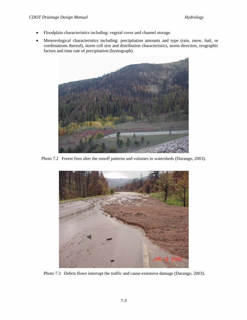
Photo 7.2 Forest fires alter the runoff patterns and volumes in watersheds (Durango, 2003).
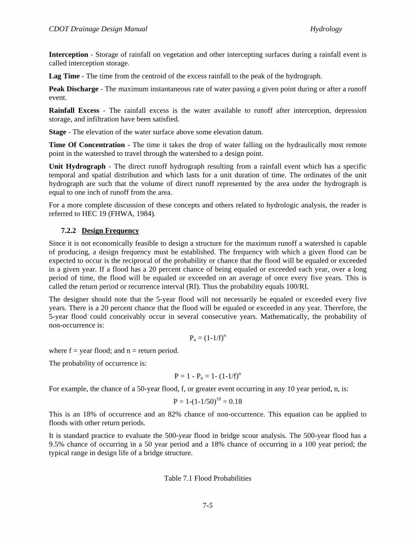
Photo 7.3 Debris flows interrupt the traffic and cause extensive damage (Durango, 2003).
CDOT Drainage Design Manual Hydrology
7-4
Photo 7.4 Vegetation and landuse significantly affect watershed hydrology.
7.2 DEFINITION OF CONCEPTS
7.2.1 Overview
The following are discussions of concepts which are important in hydrologic analysis. These concepts will be used throughout this chapter in dealing with different aspects of hydrologic studies.
Antecedent Moisture Conditions - A qualitative estimate of moisture in the soil and plants at the beginning of the storm. These conditions affect the volume of runoff generated by a particular storm event. As storm magnitudes increase, antecedent moisture has a rapidly decreasing influence on runoff because the soils become saturated.
Depression Storage - The natural depressions within a watershed that store runoff. Generally after the depression storage is filled runoff will commence.
Frequency - The number of times a flood of a given magnitude can be expected to occur on an average over a long period of time. Frequency analysis is then the estimation of peak discharges for various recurrence intervals. Another way to express frequency is with probability. Probability analysis seeks to define the flood flow with a probability of being equaled or exceeded in any year.
Hydraulic Roughness - A composite of the physical characteristics which influence the flow of water across the earth's surface, whether natural or channelized. It affects both the time response of a watershed and drainage channel as well as the channel storage characteristics.
Hydrograph - A graph of the time distribution of runoff from a watershed.
Hyetographs - A graph of the time distribution of rainfall at a point.
Infiltration - A complex process of runoff penetrating the ground surface and flowing through the upper soil layer. The infiltration curve is a graph of the time distribution at which this occurs.
CDOT Drainage Design Manual Hydrology
7-5
Interception - Storage of rainfall on vegetation and other intercepting surfaces during a rainfall event is called interception storage.
Lag Time - The time from the centroid of the excess rainfall to the peak of the hydrograph.
Peak Discharge - The maximum instantaneous rate of water passing a given point during or after a runoff event.
Rainfall Excess - The rainfall excess is the water available to runoff after interception, depression storage, and infiltration have been satisfied.
Stage - The elevation of the water surface above some elevation datum.
Time Of Concentration - The time it takes the drop of water falling on the hydraulically most remote point in the watershed to travel through the watershed to a design point.
Unit Hydrograph - The direct runoff hydrograph resulting from a rainfall event which has a specific temporal and spatial distribution and which lasts for a unit duration of time. The ordinates of the unit hydrograph are such that the volume of direct runoff represented by the area under the hydrograph is equal to one inch of runoff from the area.
For a more complete discussion of these concepts and others related to hydrologic analysis, the reader is referred to HEC 19 (FHWA, 1984).
7.2.2 Design Frequency
Since it is not economically feasible to design a structure for the maximum runoff a watershed is capable of producing, a design frequency must be established. The frequency with which a given flood can be expected to occur is the reciprocal of the probability or chance that the flood will be equaled or exceeded in a given year. If a flood has a 20 percent chance of being equaled or exceeded each year, over a long period of time, the flood will be equaled or exceeded on an average of once every five years. This is called the return period or recurrence interval (RI). Thus the probability equals 100/RI.
The designer should note that the 5-year flood will not necessarily be equaled or exceeded every five years. There is a 20 percent chance that the flood will be equaled or exceeded in any year. Therefore, the 5-year flood could conceivably occur in several consecutive years. Mathematically, the probability of non-occurrence is:
Pn = (1-1/f)n
where f = year flood; and n = return period.
The probability of occurrence is:
P = 1 - Pn = 1- (1-1/f)n
For example, the chance of a 50-year flood, f, or greater event occurring in any 10 year period, n, is:
P = 1-(1-1/50)10 = 0.18
This is an 18% of occurrence and an 82% chance of non-occurrence. This equation can be applied to floods with other return periods.
It is standard practice to evaluate the 500-year flood in bridge scour analysis. The 500-year flood has a 9.5% chance of occurring in a 50 year period and a 18% chance of occurring in a 100 year period; the typical range in design life of a bridge structure.
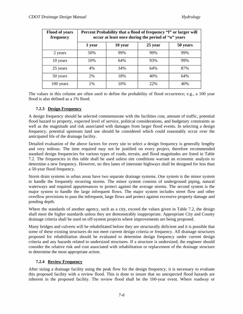
Table 7.1 Flood Probabilities
CDOT Drainage Design Manual Hydrology
7-6
Percent Probability that a flood of frequency “f” or larger will occur at least once during the period of “n” years
Flood of years frequency
1 year 10 year 25 year 50 years
2 years 50% 99% 99% 99%
10 years 10% 64% 93% 99%
25 years 4% 34% 64% 87%
50 years 2% 18% 40% 64%
100 years 1% 10% 22% 40%
The values in this column are often used to define the probability of flood occurrence; e.g., a 100 year flood is also defined as a 1% flood.
7.2.3 Design Frequency
A design frequency should be selected commensurate with the facilities cost, amount of traffic, potential flood hazard to property, expected level of service, political considerations, and budgetary constraints as well as the magnitude and risk associated with damages from larger flood events. In selecting a design frequency, potential upstream land use should be considered which could reasonably occur over the anticipated life of the drainage facility.
Detailed evaluation of the above factors for every site to select a design frequency is generally lengthy and very tedious. The time required may not be justified on every project, therefore recommended standard design frequencies for various types of roads, terrain, and flood magnitudes are listed in Table 7.2. The frequencies in this table shall be used unless site conditions warrant an economic analysis to determine a new frequency. However, no thru lanes of interstate highways shall be designed for less than a 50-year flood frequency.
Storm drain systems in urban areas have two separate drainage systems. One system is the minor system to handle the frequently recurring storms. The minor system consists of underground piping, natural waterways and required appurtenances to protect against the average storms. The second system is the major system to handle the large infrequent flows. The major system includes street flow and other overflow provisions to pass the infrequent, large flows and protect against excessive property damage and ponding depth.
Where the standards of another agency, such as a city, exceed the values given in Table 7.2, the design shall meet the higher standards unless they are demonstrably inappropriate. Appropriate City and County drainage criteria shall be used on off-system projects where improvements are being proposed.
Many bridges and culverts will be rehabilitated before they are structurally deficient and it is possible that some of these existing structures do not meet current design criteria or frequency. All drainage structures proposed for rehabilitation should be evaluated to determine design frequency under current design criteria and any hazards related to undersized structures. If a structure is undersized, the engineer should consider the relative risk and cost associated with rehabilitation or replacement of the drainage structure to determine the most appropriate action.
7.2.4 Review Frequency
After sizing a drainage facility using the peak flow for the design frequency, it is necessary to evaluate this proposed facility with a review flood. This is done to insure that no unexpected flood hazards are inherent in the proposed facility. The review flood shall be the 100-year event. Where roadway or
CDOT Drainage Design Manual Hydrology
7-7
property inundation and associated damage is judged to be severe, a higher design frequency should be considered. The design discharge used in an area that has FEMA mapped floodplain shall be the 100-year discharge.
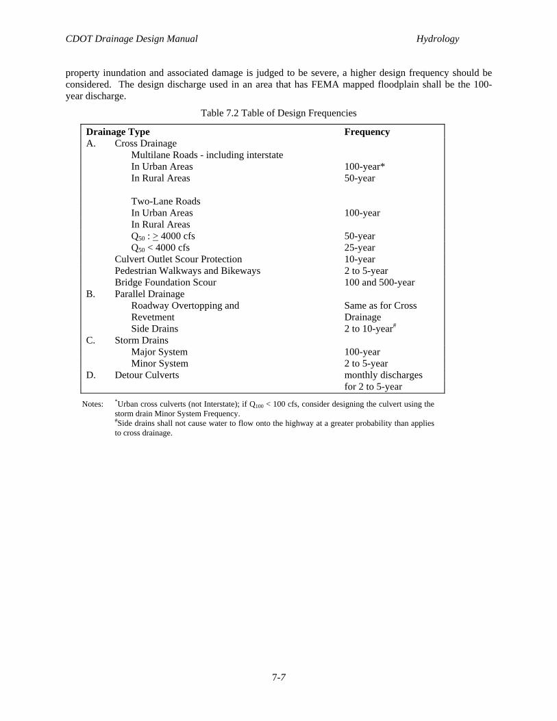
Table 7.2 Table of Design Frequencies
Drainage Type Frequency A. Cross Drainage Multilane Roads - including interstate In Urban Areas 100-year* In Rural Areas 50-year Two-Lane Roads In Urban Areas 100-year In Rural Areas Q50 : > 4000 cfs 50-year Q50 < 4000 cfs 25-year Culvert Outlet Scour Protection 10-year Pedestrian Walkways and Bikeways 2 to 5-year Bridge Foundation Scour 100 and 500-year B. Parallel Drainage Roadway Overtopping and Same as for Cross Revetment Drainage Side Drains 2 to 10-year# C. Storm Drains Major System 100-year Minor System 2 to 5-year D. Detour Culverts monthly discharges for 2 to 5-year
Notes: *Urban cross culverts (not Interstate); if Q100 < 100 cfs, consider designing the culvert using the storm drain Minor System Frequency. #Side drains shall not cause water to flow onto the highway at a greater probability than applies to cross drainage.
CDOT Drainage Design Manual Hydrology
7-8
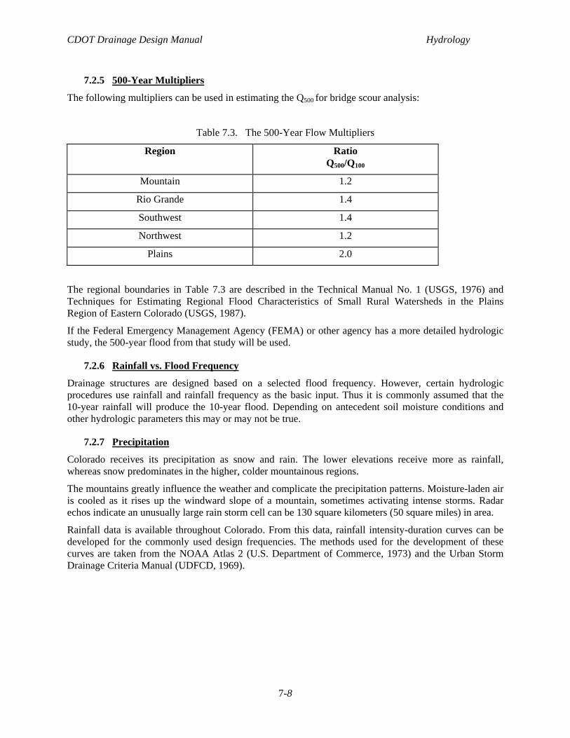
7.2.5 500-Year Multipliers
The following multipliers can be used in estimating the Q500 for bridge scour analysis:
Table 7.3. The 500-Year Flow Multipliers
Region Ratio Q500/Q100
Mountain 1.2
Rio Grande 1.4
Southwest 1.4
Northwest 1.2
Plains 2.0
The regional boundaries in Table 7.3 are described in the Technical Manual No. 1 (USGS, 1976) and Techniques for Estimating Regional Flood Characteristics of Small Rural Watersheds in the Plains Region of Eastern Colorado (USGS, 1987).
If the Federal Emergency Management Agency (FEMA) or other agency has a more detailed hydrologic study, the 500-year flood from that study will be used.
7.2.6 Rainfall vs. Flood Frequency
Drainage structures are designed based on a selected flood frequency. However, certain hydrologic procedures use rainfall and rainfall frequency as the basic input. Thus it is commonly assumed that the 10-year rainfall will produce the 10-year flood. Depending on antecedent soil moisture conditions and other hydrologic parameters this may or may not be true.
7.2.7 Precipitation
Colorado receives its precipitation as snow and rain. The lower elevations receive more as rainfall, whereas snow predominates in the higher, colder mountainous regions.
The mountains greatly influence the weather and complicate the precipitation patterns. Moisture-laden air is cooled as it rises up the windward slope of a mountain, sometimes activating intense storms. Radar echos indicate an unusually large rain storm cell can be 130 square kilometers (50 square miles) in area.
Rainfall data is available throughout Colorado. From this data, rainfall intensity-duration curves can be developed for the commonly used design frequencies. The methods used for the development of these curves are taken from the NOAA Atlas 2 (U.S. Department of Commerce, 1973) and the Urban Storm Drainage Criteria Manual (UDFCD, 1969).
CDOT Drainage Design Manual Hydrology
7-9
7.2.8 Discharge Determination
Estimating peak discharges for various recurrence intervals is one of the most common engineering challenges faced by drainage facility designers. The problem can be divided into two general categories:
• Gaged sites - the site is at or near a gaging station and the streamflow record is of sufficient length to be used to allow statistical estimates of peak discharges.
• Ungaged sites - the site is not near a gaging station and no streamflow record is available.
The following section will address hydrologic procedures that can be used for both categories.
7.3 HYDROLOGIC PROCEDURE SELECTION
7.3.1 Overview
Streamflow measurements for determining a flood frequency relationship at or near a site are usually unavailable. In such cases, it is accepted practice to estimate peak runoff rates and hydrographs using statistical or empirical methods. In general, results from using several methods should be compared, not averaged. The discharge that best reflects local project conditions, with the reasons documented, will be used.
7.3.2 Peak Flow Rates or Hydrographs
A consideration of peak runoff rates for design conditions is generally adequate for conveyance systems such as storm drains or open channels. However, if the design must include flood routing, a hydrograph is required. Although hydrograph development (more complex than estimating peak runoff rates) is often accomplished using computer programs, some methods are adaptable to desktop procedures (see the AASHTO Model Drainage Manual, Chapter 7, Appendix for more details).
7.3.3 Time of Concentration
The time of concentration, Tc, is defined as the time it takes a drop of rain falling on the hydraulically most remote point in the watershed to travel through the watershed to the first design point. It is a very important parameter at which the entire drainage basin is contributing runoff to the design point. The time of concentration usually has two components. The first is the initial time, Ti. which is the time runoff is sheet flowing. The travel time, Tt, is the time runoff is in a channel.
Tc = Ti + Tt,
For overland flow in a small basin:
Ti = 1.8(1.1 -C)D0.5' SO.33
where: Tj = minutes; C = runoff coefficient as defined in the rational equation; D = distance of flow path in feet (500 ft maximum for non-urban areas, 300 ft maximum for urban areas); S = average slope of basin in percent (see Figure 7.1).
For channel flow:
Tt = (11.9 L3/H) 0.385
where: Tt = hours; L = distance of flow path in miles; H = elevation difference from beginning of defined channel flow to the site in feet.
Or, when a channel velocity is known:
Tt= L/(60 V)
CDOT Drainage Design Manual Hydrology
7-10
Where: Tt = minutes; V = channel velocity in feet per second; L = distance in feet (see Figure 7-2).
In urban watersheds, the time of concentration at the first design point (including both channel and overland flow), shall not exceed the following:
Tc = (L/180) + 10
where: Tc = time of concentration, in minutes, at the first design point; and L =basin length in feet.
A minimum Tc is to be 5 minutes in urban areas and 10 minutes in rural areas.
Figure 7.1 Time of Concentration for Overland Flow
CDOT Drainage Design Manual Hydrology
7-11
Figure 7.2 Velocities for Estimation of Time of Concentration
CDOT Drainage Design Manual Hydrology
7-12
7.3.4 Hydrologic Peak Prediction Procedures
Many hydrologic methods are available to predict peak discharges. Each method has a range of application and limitations which the engineer should clearly understand prior to using. Basin size, hydrologic and geographic region, dominant precipitation type, elevation, and level of development are all important factors. The engineer must ensure that the selected hydrologic method is appropriate for the basin conditions and that sufficient data is available to perform the required calculations. If possible, the method should be calibrated to local conditions and flood history as described in section 7.4. Several methods will be appropriate for predicting peak flood rates and volumes at most sites. Comparison of hydrologic prediction methods on recurrence interval curves should be performed in selection of peak flow rates for design.
The following methods and sources can be used in determining peak flood magnitudes for design of CDOT drainage structures.
Analysis of Stream Gage Data - Where stream gage data are available, stream gage data can be used to develop peak discharges. The U.S. Geological Survey publishes annual stream gage data. The method used for determining the peak discharges is usually a Log-Pearson Type III distribution. A Log-Normal distribution or Gumbel Extreme Value distribution could also be used.
Log-Pearson III Flood Frequengy - Log-Pearson Type III Flood Frequency analysis shall be used for all routine designs provided there is at least 10 years of continuous or synthesized record for 10-year peak discharge estimates and 25 years for 100-year peak discharge estimates. See U.S. Water Resources Council, Bulletin 17B, (WRC, 1981).
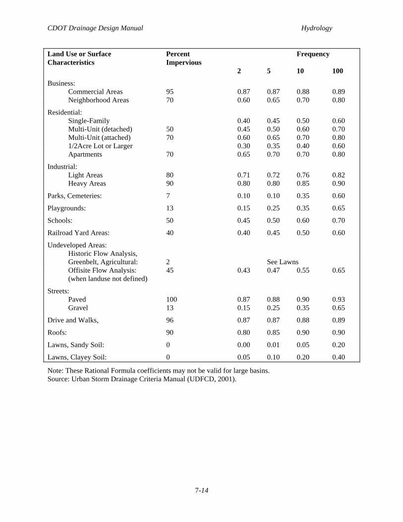
Rational Method - This empirical procedure provides peak runoff rates for small urban and rural watersheds less than 160 acres, but is best suited to urban drainage basins. Rainfall is a necessary input. The Rational Method assumes constant rainfall intensity across the entire basin and that the rainfall duration exceeds the time of concentration.
Q = C i A
Where: Q = Rate of runoff in cubic meters per second (cubic feet per second) corresponding to the rainfall frequency; C = Runoff coefficient of the area (see Table 7.4); i = Average rainfall intensity in inches per hour for a duration equal to the time of concentration; A = Area of contributing watershed in acres. A more detailed derivation of runoff coefficients based on the soil category and the percent imperviousness can be found in the Urban Storm Drainage Criteria Manual, (UDFCD, 2001).
The use of the rational method for hydrograph generation is not recommended because it underestimates the volume of runoff. The volume under the hydrograph should equal the amount of excess rainfall. A more detailed explanation of the Rational Method and an example on its use are provided in the AASHTO's, Model Drainage Manual, Chapter 7.
USGS Water Supply Papers No. 1680 - 1683 - Developed by the USGS and based on gaging station records which were regionalized to cover non-gaged basins.
Regression Equations - Peak flow can be calculated by using regression equations developed for specific geographic regions. The equations are in the form of a log-log formula, where the dependent variable would be the peak flow for a given frequency, and the independent variables may include drainage area, slope, channel geometry, and other meteorological, physical or site specific data. USGS has published regression equations for the specific geographic regions of Colorado. Currently, the publications presenting regression equations are as follows:
Technical Manual No. 1 - TM 1 was developed by the USGS in 1978. The plains regression equations are currently used for basins larger than 15 square miles. A method is presented for transferring gage data up and downstream of the gage site.
CDOT Drainage Design Manual Hydrology
7-13
Small Rural Watersheds in the Plains Region - This study was developed by the USGS in 1987. The drainage basin limits for these regression equations is 0.3 to 15 square miles.
Streamflow Characteristics in Western Colorado - developed by the USGS in 1985. The basin size limits are determined using the applicable geographical region.
Arid Watershed Study - This study was developed by the USGS in 1993 to predict peak flood magnitudes for various geographic regions in the southwestern United States. Four of these regions are in Western Colorado. Basin size limitations will vary for each geographic region but in general this method will be applicable for basins between 10 and 100 square miles
Technical Release No. 55 - Developed by the Natural Resources Conservation Service (NRCS), formerly Soil Conservation Service (SCS), for small basins. Rainfall, landuse, and the NRCS basin soil types and conditions are the required input. This method tends to over predict frequently occurring events and under predict rare events.
Paleohydrology - Developed specifically for the foothills region of the plains below 8000 feet in elevation. Information from the 1976 Big Thompson flood was used to generate regression equations.
Channel Geometry - This method uses the active channel width, stream type, and terrain to predict discharge. Channel geometry method is most accurate when applied to perennial streams with stable banks. Field procedures and regression equations are given. See USGS, Streamflow Characteristics Related to Channel Geometry of Streams in Western United States - Water Supply Paper 2193.
Flood Insurance Study - The 100-year discharges specified in the FEMA flood insurance study shall be used to analyze impacts of a proposed crossing on a regulatory floodway. However, if these discharges are deemed to be outdated, the discharges based on current methods may be used subject to receipt of necessary regulatory approvals.
Colorado Urban Hydrograph Procedure - This method was developed by Urban Drainage and Flood Control District of Denver (UDFCD) for urban basins with areas greater than 90 acres. This method can be used for peak flows and hydrographs. Snyder's Unit Hydrograph method is the basis for this procedure. The equations, coefficients and procedures are available in the Urban Storm Drainage Criteria Manual (UDFCD, 2001).
Snyder's Unit Hydrograph - This method, developed in 1938, has been used extensively by the Corps of Engineers and provides a means of generating a synthetic unit hydrograph. Rainfall is a necessary input. Further explanation and examples are presented in the AASHTO's Model Drainage Manual, Chapter 7.
SCS Synthetic Unit Hydrograph - The Soil Conservation Service has developed a synthetic unit hydrograph procedure which has been widely used for developing rural and urban hydrographs. The unit hydrograph used by the NRCS method is based upon an analysis of a large number of natural unit hydrographs from a broad cross section of geographic locations and hydrologic regions. Rainfall is a necessary input. Further explanation and example are presented in the AASHTO's Model Drainage Manual, Chapter 7.
Several of these methods are available in the computer program Hydrain Drainage Design System. The hydrologic model within the Hydrain system is called Hydro and this model allows the user to select among several hydrologic procedures. HEC-HMS, HEC 1, SWMM and TR-20 are also available and may be used to facilitate tedious hydrologic calculations.
Table 7.4 Recommended Runoff Coefficients for Use in Rational Equation as a function of Percent Impervious Area and Landuse Types.
CDOT Drainage Design Manual Hydrology
7-14
Land Use or Surface Percent Frequency Characteristics Impervious 2 5 10 100
Business: Commercial Areas 95 0.87 0.87 0.88 0.89 Neighborhood Areas 70 0.60 0.65 0.70 0.80
Note: These Rational Formula coefficients may not be valid for large basins. Source: Urban Storm Drainage Criteria Manual (UDFCD, 2001).
CDOT Drainage Design Manual Hydrology
7-15
7.4 CALIBRATION
7.4.1 Definition
Calibration is a process of varying the parameters, coefficients or recurrence interval curve of a hydrologic method so that it will estimate peak discharges and hydrographs consistent with local rainfall, basin characteristics, streamflow data and flood history. When it becomes necessary to use unreasonable values for parameters or coefficients in order for the model to produce reasonable results, then the model should be considered suspect and its use carefully considered (e.g., having to use terrain variables that are obviously dissimilar to the geographic area in order to calibrate to measured discharges or hydrographs).
7.4.2 Calibration with Flood History
Flood history for highway crossings can often be obtained from the highway maintenance personnel. Staff Hydraulics has a flood history program, in which flood history forms are completed by CDOT maintenance forces. Long time, local residents can also be a source of flood history. Flood history must be used with caution as any extreme flood or a long period of below normal runoff may unduly influence the predicted peak flow.
The discussion given in 7.2.1 can be used to determine the frequency of a given flood history event (i.e. overtopping).
7.4.3 Calibration without Flood History
Calibration done with little or no flood history is based on the physical characteristics of the basin. Sound hydrologic principles should be employed for this type of calibration. An example of calibration with little flood history, would be increasing the time of concentration to account for an unusually long and narrow basin or decreasing the time of concentration for a steep basin,
7.5 RISK ANALYSIS
7.5.1 Definition
Risk is defined as the consequences associated with the probability of flooding attributable to a given structure. There is a level of risk associated with every structure.
Risk analysis is a method to select a design which will result in the Least Total Expected Cost (LTEC) to the traveling public. Risk analysis involves analyzing the losses incurred to various design options due to possible flooding. The product of the risk analysis is the annual economic risk associated with each design option.
The sum of the annual economic risk and the annual capital costs, the total construction costs multiplied by a capital recovery factor, results in the Total Expected Cost (TEC) for each design option. Comparison of the TEC's for all the design options allows the designer to select the option with the least total expected cost.
7.5.2 Usage
Risk analysis is used when the initial costs of a conventional design appear to produce either too much risk or excessive costs for a given site or if requested by the Region.
CDOT Drainage Design Manual Hydrology
7-16
7.5.3 Factors
The following list of items shall be assessed in performing a risk analysis:
• Construction costs;
• Probable property and highway damage;
• Traffic delays;
• Availability of alternate routes; and
• Intangible considerations including loss of emergency supply and evacuation routes, legal costs and the potential loss of life require a qualitative assessment.
The items to be used for a site-specific risk analysis may not be limited to this list but may include additional items.
For each design option, the costs derived from the above list should be annualized over the design life of the facility before comparison with other design options.
Federal Highway Administration's HEC 17 provides a more comprehensive source of information and methods for performing a risk analysis.
CDOT Drainage Design Manual Hydrology
7-17
REFERENCES American Association of State Highway and Transportation Officials, “Model Drainage Manual,” 2003.
Colorado Department of Transportation, “Roadway Design Manual,” 1990.
Colorado Water Conservation Board, “Colorado Flood Hydrology Manual,” 1994 and 2004 (draft).
Urban Drainage and Flood Control District, “Urban Storm Drainage Criteria Manual,” 1969 and 2001.
U.S. Department of Agriculture, Soil Conservation Service, “Procedures for Determining Peak Flows in Colorado,” Technical Release 55, 1984.
U.S. Department of Commerce, National Oceanic and Atmospheric Administration, National Weather Service, “NOAA Atlas 2, Volume III, Colorado,” 1973.
U.S. Department of Transportation, Federal Highway Administration, “Hydrology,” Hydraulic Engineering Circular No. 19, October 1984.
U.S. Department of Transportation, Federal Highway Administration, “The Design of Encroachments on Flood Plans Using Risk Analysis, Hydraulic Engineering Circular No. 17,” April 1981.
U.S. Geological Survey, “Manual for Estimating Flood Characteristics of Natural Flow Streams in Colorado,” Technical Manual No. 1, 1976.
U. S. Geological Survey, “Estimation of Natural Streamflow Characteristics in Western Colorado,” Water Resources Investigations Report 85-4086, 1985..
U. S. Geological Survey, “Techniques for Estimating Regional Flood Characteristics of Small Rural Watersheds in the Plains Region of Eastern Colorado,” Water Resources Investigation Report 87-4094, 1987.
U. S. Geological Survey, “Streamflow Characteristics Related to Channel Geometry of Streams in Western United States,” Water Supply Paper 2193, 1982.
U.S. Geological Survey, “Methods for Estimating Magnitude and Frequency of Floods in the Southwestern United States,” Open File Report 93 -419, 1993.
Water Resources Council, “Guidelines for Determining Flood Flow Frequency,” Bulletin 17B, Revised September 1981.