58
AN UPDATE TO THE 2016 PENDER COUNTY COLLECTOR STREET PLAN DRAFT

AN UPDATE TO THE 2016 PENDER COUNTY COLLECTOR STREET PLAN
DRAFT

DRAFT

i
ACKNOWLEDGEMENTSPENDER COUNTY BOARD OF COMMISSIONERS
George Brown, ChairmanFred McCoy, Vice-ChairmanJackie NewtonDavid PiepmeyerDavid Williams
PENDER COUNTY PLANNING BOARD
Theo McClammy, ChairpersonDelva Jordan, Vice-ChairpersonJeffrey PittsDamien BuchananJohn R. GruntfestNorman K. TeacheyJeff Beaudoin Commissioner David Piepmeyer (Alternate)
PENDER COUNTY PLANNING & COMMUNITY DEVELOPMENT
Travis Henley, MPA, CFM, DirectorVanessa Lacer, MPA, Long Range Planner
WILMINGTON URBAN AREA METROPOLITAN PLANNING ORGANIZATION
Mike Kozlosky, Executive DirectorAbby Lorenzo, Deputy DirectorRachel McIntyre, PLA, Associate Transportation Planner
CONSULTANT TEAM
Will Letchworth, PEShivang Shelat, AICPKatharine Mather, AICPSarah Parkins, AICP
DRAFT

ii
This page intentionally left blank.
DRAFT

iii
TABLE OF CONTENTSINTRODUCTION.............................1
Study AreaWhat are Collector Streets?Collector Streets in the Functional Classification SystemVision and Goals
EXISTING CONDITIONS................5
2016 Pender County Collector Street PlanRegional Planning DocumentsNatural and Built EnvironmentTraffic ConditionsTraffic Modeling
PUBLIC OUTREACH AND STAKEHOLDER ENGAGEMENT...13
Phase I (March/April 2021)Phase II (May/June 2021)
METHODOLOGY...........................17
Development of Collector Street Recommendations
RECOMMENDATIONS................25
RoadwayBicycle and PedestrianStreet Cross SectionsPolicy RecommendationsPolicy StrategiesConclusion
12345
DRAFT

iv
This page intentionally left blank.
DRAFT

INTRODUCTION | PAGE 1
PENDER COUNTY STREETS PLAN 2021
The Wilmington Urban Area Metropolitan Planning Organization (WMPO), by request and in partnership with the Pender County Planning and Community Development Department (Planning Department), has commissioned an update to the 2016 Pender County Collector Street Plan (the 2016 Plan) to determine future transportation needs in southeastern Pender County.
The 2016 Plan developed recommendations for new collector street alignments and bicycle and pedestrian facilities. Upon implementation of the 2016 Plan, the rigidity and specificity of the collector street recommendations, as well as the lack of consideration for natural resources, North Carolina Department of Transportation (NCDOT) design requirements, and the realities of development in a coastal county, have created multiple requests for variances and pushback from the development community. Southeastern Pender County has seen high growth rates since 2016 and changes in regional plans and projects such as the adoption of the WMPO’s 2045 Metropolitan
INTRODUCTION
Transportation Plan (MTP), the NCDOT 2020-2029 State Transportation Improvement Program (STIP), an update to Pender County’s land use plan in 2018, and the progression of the US 17/Hampstead Bypass, necessitates an update to the 2016 Plan that addresses future transportation needs while affording flexibility in implementation.
This report details the planning process undertaken between January 2021 and June 2021 to update the 2016 Plan and the resulting recommendations.
STUDY AREA
This 2021 Plan Update (the Update) maintains the same study area used in the 2016 Plan. The study area is bordered by NC 210 to the north, the Pender/New Hanover County boundary to the east and south, and Black River to the west. Figure 1-1 on the following page shows the study area.
DRAFT

PAGE 2 | INTRODUCTION
PENDER COUNTY STREETS PLAN 2021
Figure 1-1 | Collector Street Plan Study Area
WHAT ARE COLLECTOR STREETS?
Collector streets are defined as streets that connect local roads and neighborhoods to arterial roadways. Examples of collector streets in the study area include Country Club Drive, Sloop Point Loop Road, NC-133, and Hoover Road. Collector streets are typically two lanes, two to three miles in length, have speed limits between 25 and 45 miles per hour, and accommodate lower volumes of traffic.
Collector streets serve a number of important functions within the street network. They are very important in reducing congestion on arterial roads by equitably distributing the traffic burden so that shorter, local trips use the collector street system and long-distance trips remain on the arterial streets. Another important benefit is providing enhanced mobility opportunities for all roadway users, including emergency service providers, pedestrians, bicyclists, and municipal services.*
*There are no municipalities within the study area.Existing Collector Street, Sloop Point Loop Road
DRAFT

INTRODUCTION | PAGE 3
COLLECTOR STREETS IN THE FUNCTIONAL CLASSIFICATION SYSTEM
Roadways serve two primary functions: mobility, the ability to move from one place to another; and access, opportunities for entry to/exit from specific locations (driveways) along a route. Most roadways provide a combination of mobility and access. In terms of function, there are three general categories of roadways:
Arterials
Arterial roadways provide a high level of mobility and are used mostly for long-distance travel. Some arterials are designed as controlled access or partially controlled access facilities. These facilities, which include Interstates, freeways, and expressways, limit the number of locations where vehicles can enter or exit. Examples in the study area include I-40 and I-140. Other arterials are designed with signalized
intersections to control traffic flow. In these cases, the arterial roadway receives most of the green time. Examples in the study area include US 421 and US 17.
Collectors
Collector streets provide a balance between mobility and access. For more information on collector streets, refer to the previous section on page 2.
Local Streets
Local streets provide a high level of access. With many driveways providing direct access to adjacent land uses, local streets are not designed to carry through traffic. According to the Federal Highway Administration (FHWA), often, after all arterials and collector streets have been identified, the remaining roadways are classified as Local Streets by default.
Figure 1-2 above illustrates the hierarchy of and differences between the roadway classifications.
ARTERIALS
LOCAL STREETS
COLLECTORS
High
Low
MO
BILI
TY(S
peed
)
Low
Low Low
Low
High
High High
High
ACCE
SS(#
Driv
eway
s)
DIS
TAN
CES T
RAVE
LED
AVER
AGE
AN
NU
AL
DA
ILY
TRA
FFIC
MIL
ES O
F RO
ADW
AY
Source: https://www.fhwa.dot.gov/planning/processes/statewide/related/highway_functional_classifications/section02.cfm
Figure 1-2 | Functional Classification of Roadways
DRAFT

PAGE 4 | INTRODUCTION
PENDER COUNTY STREETS PLAN 2021
VISION AND GOALS
This Update builds upon the 2016 Plan. The analysis and recommendations incorporate new data and analysis techniques to provide better direction for obtaining the vision and goals of the 2016 Plan.
The vision for this Update, carried forward from the 2016 Pender County Collector Street Plan, is as follows:
The purpose of a collector street plan for Pender County is to guide investment in new collector streets to improve connectivity, inform land development, maintain acceptable levels-of-service on existing roadways, ensure conservation of natural areas, and provide a safe and high-quality transportation network for residents, businesses, and visitors using all modes of travel.
In order to achieve this vision, the 2016 Plan established the following goals, which remain in place for this Update:
1 Develop a realistic and feasible network of collector streets that support the local street and arterial system
2 Work with the development community to ensure proper connectivity and collector street design
3 Be sensitive to environmental issues and “build-in” context-sensitive design approaches where applicable
4 Integrate multimodal design features into the street design that support walkability and bikability
“To improve connectivity, inform land development, maintain acceptable levels-of-service
on existing roadways, ensure conservation of natural areas, and
provide a safe and high-quality transportation network for residents,
businesses, and visitors using all modes of travel. ”
-2016 Pender County Collector Street Plan Vision
DRAFT

EXISTING CONDITIONS | PAGE 5
2016 PENDER COUNTY COLLECTOR STREET PLAN
The 2016 Pender County Collector Street Plan (the 2016 Plan) surveyed existing conditions, conducted public outreach, developed recommendations, and identified design requirements and policy strategies. New and existing collector street recommendations were developed based on analysis of existing land use and trip generation into a “Preferred Scenario.” This “Preferred Scenario” is presented in Figure 2-1 on the following pages. Nine typical sections were identified and categorized into five groups for implementation. Each collector street recommendation was assigned to one of these five groups. The typical sections in each group vary in the multimodal facilities provided to allow flexibility in implementation.
Additionally, the 2016 Plan proposed eleven supporting policy recommendations that addressed
EXISTINGCONDITIONS
stormwater integration, street spacing and access, multimodal facility integration, traffic impact analyses, environmental conservation, and maintenance.
The 2016 Plan was used as the basis to begin the analysis for this 2021 Plan Update (the Update), though new data was used when available.
EXISTINGCONDITIONS
DRAFT

PAGE 6 | EXISTING CONDITIONS
PENDER COUNTY STREETS PLAN 2021
MAT
CH L
INE
| See
Pag
e 7 M
ATCH LINE | See Page 6
PAGE 6 | EXISTING CONDITIONS
PENDER COUNTY STREETS PLAN 2021
LAND USE INTENSITY/TYPE OF COLLECTOR STREET INTENSITY ACCESS
FUNCTIONAPPROX. STREET
SPACINGNo Collector Streets (Environmental
Conservation) Little to No Development N/A N/A
Lowest Intensity (Rural Agricultural) Less than 2 Dwelling Units per Acre Highest 3,000 to 6,000 feet
apartMedium Intensity (General Business,
General Industrial, Industrial Transition, Manufactured Housing Community,
Residential Performance)
2 to 4 Dwelling Units per Acre High 1,500 to 3,000 feet
apart
High Intensity (Residential Mixed, Office Institutional, Planned Development)
More than 4 Dwelling Units per Acre/Activity
NodesMedium 750 to 1,500 feet
apart
MAT
CH L
INE
| See
Pag
e 7 M
ATCH LINE | See Page 6
NOTE: Table included as part of Figure 2-1
DRAFT

EXISTING CONDITIONS | PAGE 7
REGIONAL PLANNING DOCUMENTS
Cape Fear Moving Forward 2045 Metropolitan Transportation Plan
The WMPO’s adopted Metropolitan Transportation Plan (MTP), Cape Fear Moving Forward 2045, provides a multimodal transportation framework to guide future transportation investment within the WMPO’s boundary. MTPs are fiscally constrained,
meaning only projects that can be constructed with expected funding are included. This differs from a collector street plan, where recommendations are made in advance of known funding and, therefore, the plan can guide future transportation projects as funding becomes available. As most collector streets will be funded and constructed as part of new developments, these streets are typically funded from private sources.
Table 2-1 on the following page presents the roadway projects identified in the 2045 MTP that are within
Figure 2-1 | ”Preferred Scenario” from the 2016 Pender County Collector Street Plan
MATCH LINE | See Page 6
DRAFT

PAGE 8 | EXISTING CONDITIONS
PENDER COUNTY STREETS PLAN 2021
MTP PROJECT NUMBER
PROPOSED PROJECT
PROPOSED PROJECT LIMITS
HORIZON YEAR
RW-6 Hoover Road Widening Hoover Road from US 17 to Blue Clay Road 2030
RW-13 Godfrey Creek Road Extension
Godfrey Creek Road from Godfrey Creek to Saint Johns Church Road 2035
RW-18 Sloop Point Road Widening Sloop Point Road from US 17 to road terminus 2040
RW-23 Sidbury Road Widening Sidbury Road from Blue Clay Road to US 17 2045
RW-29, 30, & 31 Center Drive ExtensionCenter Drive from about 600' east of US 17
along Whitebridge Road to roughly 1,000' east of US 17 along Scotts Hill Lopp Road
2045
RW-35 Harrison Creek Road Extension
Harrison Creek Road from an extension of Holliday Dr to Realigned intersection of US 17
and Washington Acres Rd2045
RW-166 Future NC417/Hampstead Bypass & Sidbury Road Interchange* 2035
Table 2-1 | 2045 MTP Projects within the Study Area
STIP PROJECT NUMBER
PROPOSED PROJECT
PROPOSED PROJECT LIMITS
CONSTRUCTION FISCAL YEAR (FY)
R-3300 Hampstead Bypass US 17 at Long Leaf Drive to I-140 FY 2022**
U-5732 US 17 Conversion to Superstreet
Washington Acres Road to Sloop Point Road FY 2029**
Table 2-2 | 2020-2029 STIP Projects within the Study Area
the study area. The recommendations made in this Update assume the implementation of these projects.
NCDOT 2020-2029 STIP
The NCDOT 2020-2029 State Transportation Improvement Program (STIP) identifies the schedule and funding of all transportation projects to be conducted by NCDOT over the next ten years. Table 2-2 below presents the roadway projects identified in the 2020-2029 STIP that are within the study area. The recommendations made in this Update assume the implementation of these projects.
Pender 2.0: Comprehensive Land Use Plan
Pender 2.0: Comprehensive Land Use Plan (Land Use Plan) was adopted in August 2018 to guide the future growth of Pender County by addressing needs related to environmental protection, community facilities and services, and future land use. The Land Use Plan identifies 12 land use classifications for parcels located in unincorporated parts of the county. (There are no incorporated areas within the study area.) These land use classifications are presented in Figure 2-2 on the opposite page.
*Project located in New Hanover County but significant for the study area**Construction Fiscal Years taken from the May 2021 STIP
DRAFT

EXISTING CONDITIONS | PAGE 9
The majority of future land use classifications within the study area are residential. Mixed-use classifications are concentrated along US 17 and in isolated pockets along US 117 and NC 210. Rural agriculture classifications are located adjacent to US 421 and along the Northeast Cape Fear River. The only industrial classifications within the study area are located east of I-40 and along US 421 near the southern edge of the study area boundary.
Land use classifications within the study area are notably denser than in other unincorporated areas of Pender County—almost all residential and mixed-use classifications are concentrated within the study area. This is reflective of the influence of urban growth from New Hanover County. Within the study area, the densest classifications are adjacent to the arterial roadways that directly connect Pender and New Hanover Counties including US 17, US 117, the southern portion of US 421, and NC 133.
These land use classifications were used as the basis for the development of recommendations prepared in this Update.
Figure 2-2 | Pender County Future Land Use Map
NATURAL AND BUILT ENVIRONMENT
A review of the natural and built environment was conducted through desktop analysis and WMPO GIS shapefile data. This review was not intended to serve as a formal environmental review, but rather to guide the development of recommendations. Implementation of the recommendations made in this Update is subject to compliance with all necessary environmental reviews and/or permitting requirements.
The high-level review revealed that protected lands, including Natural Heritage Areas and state-owned lands, are located throughout the study area but concentrated west of US 421, south of NC 133 between US 421 and US 117, and west and east of the Northeast Cape Fear River (see Figure 2-3 on the following page). Data from the National Wetland Inventory and the North Carolina Flood Risk Information System were used as wetland and floodplain sources, respectively. These sources indicated that potential wetlands and 100-year floodplains are scattered throughout the study area
0 1 2 Miles
DRAFT

PAGE 10 | EXISTING CONDITIONS
PENDER COUNTY STREETS PLAN 2021
but are concentrated at the previously identified protected lands and between US 117 and I-40 and south of NC 210/Island Creek Road between the study area boundary and US 17. These natural resources were combined with future land use data to serve as the basis for the recommendations made in this Update.
Excluding the existing built areas east of US 17, the study area is mostly undeveloped. Concentrations of existing development include residential development between Clarks Landing Road and US 117, and small-scale residential developments along NC 210 between the Northeast Cape Fear River and US 17. Considering the extent of future residential classifications from the Land Use Plan, there is high potential for future development within the study area.
TRAFFIC CONDITIONS
Existing traffic patterns and volumes were derived from StreetLight Data and Average Annual Daily Traffic (AADT) data from NCDOT. One key difference between these two datasets is that AADT presents the traffic volumes of an average day in 2019, without accounting for seasonal or daily fluctuations. The StreetLight Data extracted for this analysis
presents traffic volumes on an average day in the months of March and October of 2019, when traffic volumes are typically representative of normal traffic patterns. The chosen analysis year was 2019 due to abnormal travel patterns in 2020 related to the COVID-19 pandemic.
NCDOT AADT data indicates that the average daily traffic volume along US 17 is approximately 36,000 vehicles per day (vpd) north of Belvedere Drive; 43,500 vpd between NC 210 and Belvedere Drive; and 40,000 vpd south of NC 210. The daily traffic volume along NC 210 averages 9,300 vpd near the intersection with US 17; 2,100 vpd near the intersection with NC 133; and 15,000 vpd between I-40 and US 117. Along US 117, daily traffic volume ranges between 7,000 and 14,000 vpd. Daily traffic on NC 133 averages from 11,000 vpd at US 117 to 2,300 vpd at US 421. Average daily traffic on US 421 varies from 5,700 vpd at NC 133 to 7,600 vpd near the Pender/New Hanover County border.
As NCDOT AADT data does not indicate the distribution of traffic, StreetLight Data was used to provide this information. Figure 2-4 on the opposite page presents the study area, divided in two halves by the Northeast Cape Fear River. Based on the StreetLight Data analysis, the western and eastern
0 1 2 Miles
Figure 2-3 | Natural Resources in the Study Area
DRAFT

EXISTING CONDITIONS | PAGE 11
halves generated 21,710 and 74,850 daily trips in 2019, respectively. See Appendix A for StreetLight Data outputs.
In the western half, 24% of trips remained within this half of the study area; 60% of trips were to or from New Hanover and Brunswick Counties; and only 15% of trips traveled to and from north of the study area. There was a high volume of pass-through traffic, 38,250 vpd, in the western half due to the presence of multiple north-south routes including I-40, US 421, and US 117. In the eastern half, 38% of the trips remained within this half of the study area; 38% of trips traveled to and from New Hanover County; and 23% of trips traveled north of the study area. In addition to those trips, there were about 16,200 daily trips that traveled through the eastern half of the study area. Approximately 900 daily trips are made between the eastern and western halves of the study area, which accounts for the remaining 1% of total trips in each half.
NCDOT AADT data was used to develop future traffic projections along existing arterial roads. The historical AADT values at various locations along these roads were tabulated and projected to future year 2045 using a straight-line projection method. These values
0 1 2 Miles
Figure 2-4 | StreetLight Data Traffic Distribution
were compared to the roadway capacity and Travel Demand Model-based travel projections, which are discussed in the Methodology section of this Update.
TRAFFIC MODELING
The latest update to the WMPO’s adopted Travel Demand Model (TDM) occurred in November 2020. The TDM projects travel demand based on projected population and employment levels in 2045 while assuming the infrastructure improvements in the MTP. The TDM has been an appropriate tool for forecasting needs in more urban New Hanover County, but analysis performed during this Update indicates that the population and employment projections for Pender County may not be reflective of development patterns as the rate of development is typically higher. This difference is further distorted due to the adoption of the Land Use Plan, which dedicates more land for higher density development than what was assigned in the previous land use plan and TDM. As the TDM only features major arterial roads within the study area, the TDM is unable to provide a sufficient basis for the development of collector streets.
DRAFT

PAGE 12 | EXISTING CONDITIONS
PENDER COUNTY STREETS PLAN 2021
For the development of this Update, the TDM was used to determine the daily vehicle carrying capacities of each roadway classification. These capacities were compared with the traffic projections based off of AADT values and those from the TDM to determine which roadway segments may be over capacity in the future on a daily volume basis and peak-hour basis. Appendix B presents the calculations used for this comparison. The analysis suggested the daily traffic volumes on almost all arterial roads will be lower than their daily carrying capacity. However, during peak hours, many portions of US 17 and NC 210 may experience significant congestion. The AADT projections for
US 17 were highly overestimated because they did not consider the distribution of traffic related to the future Hampstead Bypass. However, even after adjusting the volumes to consider the future bypass, US 17 may still experience congestion at certain locations during peak hours. This conclusion, combined with the earlier observation that there is a significant volume of intra-zonal trips in the region, indicates collector streets parallel to US 17 may be required to address local traffic needs and alleviate congestion on US 17.
DRAFT

PUBLIC OUTREACH AND STAKEHOLDER ENGAGEMENT | PAGE 13
PUBLIC OUTREACH AND STAKEHOLDER
ENGAGEMENT
Two periods of public outreach and stakeholder engagement were held during the development of the 2021 Plan Update (the Update). Key takeaways from the engagement periods are highlighted below. Detailed summaries and findings from each engagement period are presented in Appendix C.
PHASE I (MARCH/APRIL 2021)
The first round of public engagement was held in March and April 2021 to seek feedback on the 2016 Pender County Collector Street Plan (the 2016 Plan), identify conditions that have changed since 2016, and understand current transportation and development needs and concerns. An online survey provided the opportunity for public comments and 440 responses were received. Members of the development and real estate community were included through a parallel online survey and a Stakeholder Steering Committee meeting.
Responses and feedback received during this engagement period were used in the development of the draft recommendations.
PHASE I PUBLIC SURVEY RESULTS
Results of the public survey indicated most respondents experience delays during their daily travel during peak times and that seasonal travel impacts related to tourism often lead to considerable delays. Responses further indicated delayed travel times are typically experienced along US 17, specifically at the intersections of NC 210, County Club Road, Topsail Schools, Sloop Point Road, and Washington Acres Road. Seventy-seven percent of respondents also noted US 17 as a concern through a separate comment.
When asked if respondents would walk or bike more often within the study area if better, safer facilities were available, 58% of respondents answered yes, 22% answered no, and 20% answered maybe.
DRAFT

PAGE 14 | PUBLIC OUTREACH AND STAKEHOLDER ENGAGEMENT
PENDER COUNTY STREETS PLAN 2021
Finally, respondents were asked to select their top three transportation priorities from a list of eight options. Responses to this question are shown in Figure 3-1 above.
DEVELOPER SURVEY AND STAKEHOLDER MEETING I RESULTS
The developers survey received three responses, which are recorded in Appendix C.
Stakeholder meeting participants indicated the 2016 Plan was generally not helpful for guiding development and site plan design. Further, participants indicated general infrastructure needs, such as utilities and schools, were barriers to future development in addition to transportation and traffic needs. Figure 3-2 on page 15 presents the selection of transportation elements participants saw as important for future development.
PHASE II (MAY/JUNE 2021)
In order to present the draft recommendations to the public and collect feedback on various elements of the recommendations, an ESRI Storymap website was developed. The website was available
16
Responses and feedback received in this engagement period were used in the development of the draft recommendations.
Public Survey Results
Results of the public survey indicated most respondents experience delays during their daily travel during peak times and that seasonal travel impacts related to tourism often lead to considerable delays. Responses further indicated delayed travel times are typically experienced along US 17, specifically at the intersections of NC 210, County Club Road, Topsail Schools, Sloop Point Road, and Washington Acres Road. 77% of respondents also noted US 17 as a concern through a separate comment. When asked if respondents would walk or bike more often within the study area if better, safer facilities were available, 58% of respondents said yes, 22% said no, and 20% said maybe. Finally, respondents were asked their top three transportation priorities from a list of eight options. Responses to this question are shown in Figure 14. Figure 14 – Transportation Priorities Identified in the First Public Survey
Developer Survey and Stakeholder Meeting Results
The developers survey received three responses; these responses are recorded in Appendix C. Meeting participants indicated the 2016 Plan was generally not helpful for the guiding development and site plans. Further, participants indicated general infrastructure needs, such as utilities and schools, were barriers to future development in addition to transportation and traffic needs. Figure 15 presents the selection of transportation elements participants saw as important for future development.
6.33%
15.30%
14.51%
33.51%
34.83%
35.36%
40.37%
53.83%
64.64%
Other (please specify)
Lighting and landscaping
Availability of marked/signalized crosswalks
Availability of sidewalks
Availability of bike lanes or multi-use paths
Avoiding environmental sensitive areas, such…
More connections between neighborhoods
Safety for all travelers
Faster, more direct connections to destinations
0% 10% 20% 30% 40% 50% 60% 70%
Select your top three priorities to be addressed when new collector streets are being constructed.
Figure 3-1 | Transportation Priorities Identified in the First Public Survey
from May 17th until June 21st 2021. The website, made available at www.tinyurl.com/PenderStreets, included four sections: Overview, Methodology, Draft Recommendations, and Next Steps. An interactive map of the draft recommendations was available for users to see the recommendations in detail. Survey questions were asked throughout the website using ESRI’s Survey123 tool. Eight questions were asked, in addition to 11 optional demographic questions. In total, there were 639 unique visitors to the website, and 22 individuals completed at least one survey question.
PHASE II PUBLIC SURVEY RESULTS
Questions asked respondents to rate how they felt about the proposed collector street recommendations, broken up by region, on a scale from strongly disagree to strongly agree. There was a total of 13 responses for each of the three questions. Figure 3-3 on page 15 shows the results for each region. It can be inferred from the results that most respondents agree with the collector street alignment recommendations. Another question asked respondents to rate their opinion of the proposed bicycle and pedestrian recommendations. A total of 12 responses were received, shown in Figure 3-4 on page 15. A majority of the respondents strongly agreed with the proposed recommendations.
DRAFT

PUBLIC OUTREACH AND STAKEHOLDER ENGAGEMENT | PAGE 15
17
Figure 15 – Development Preferences Identified in the First Stakeholder Meeting
May/June 2021 Engagement In order to present the draft recommendations to the public and collect feedback on various elements of the recommendations, an ESRI Storymap website was developed. The website was available from May 17th until June 21st 2021. The website, made available at www.tinyurl.com/PenderStreets, included four sections: an Update overview, methodology, draft recommendations, and next steps. An interactive map of the draft recommendations was available for users to see the recommendations in detail. Survey questions were asked throughout the website using ESRI’s Survey123 tool. There was a total of eight questions asked, as well as 11 optional demographic questions. In total, there were 639 unique visitors to the website, and 22 individuals completed at least one survey question. Public Survey Results
Questions were asked respondents to rate how the felt about the proposed collect street recommendations, broken up by region, on a scale from strongly disagree to strongly agree. There was a total of 13 responses for
0%
0%
20%
20%
20%
13%
20%
7%
0% 5% 10% 15% 20% 25%
Lighting and landscaping
Availability of marked/signalized crosswalks
Availability of sidewalks
Availability of bike lanes or multi-use paths
Avoiding environmental sensitive areas, such as…
More connections between neighborhoods
Safety for all travelers
Faster, more direct connections to destinations
1 1 11
0 0
1
3
2
3
1 1
5
6 6
1 1
3
0
1
2
3
4
5
6
7
South Eastern North Eastern Western
Strongly Disagree Disagree Neutral Agree Strongly Agree No Opinion
Figure 16: Survey Results – Respondent opinions on Collector Street Recommendations
18
each of the three questions. Figure 16 shows the results for each region. It can be inferred from the results that most respondents agree with the collector street alignment recommendations. Another question asked respondents to rate their opinion on the proposed bicycle and pedestrian recommendations. A total of 12 responses were received, shown in Figure 17. A majority of the respondents strongly agreed with these proposed recommendations.
Stakeholder Meeting
A stakeholder meeting was held on May 20, 2021 to share the draft recommendations and collect feedback from stakeholders in the land development and real estate community. The purpose the meeting was to present data collected on current travel patterns, the methodology to determine future collect street needs, the geographies of proposed collector streets, and recommendations for bicycle and pedestrian facilities and street sections. The meeting was held at the City of Wilmington municipal building at 305 Chestnut Avenue and via Zoom. There were a total of six stakeholders who attended in-person and four stakeholders who attended virtually. The stakeholders included mostly representatives of development organizations and real estate agencies, as well as a Pender County planning board member. The meeting minutes are included in Appendix C. The format of the meeting included a presentation, followed by an open discussion. Maps of the draft recommendations were also available to the attendees who attended the in-person meeting. The presentation was given by the study team including Abby Lorenzo with the WMPO, Travis Henley with Pender County, and Will Letchworth, Shivang Shelat, and Sarah Parkins with WSP. The presentation is included in Appendix C.
Figure 17: Survey Results – Respondent opinions on Bicycle and Pedestrian recommendations
01
01
10
00
2
4
6
8
10
12
Strongly Disagree Disagree Neutral Agree Strongly Agree No Opinion
17
Figure 15 – Development Preferences Identified in the First Stakeholder Meeting
May/June 2021 Engagement In order to present the draft recommendations to the public and collect feedback on various elements of the recommendations, an ESRI Storymap website was developed. The website was available from May 17th until June 21st 2021. The website, made available at www.tinyurl.com/PenderStreets, included four sections: an Update overview, methodology, draft recommendations, and next steps. An interactive map of the draft recommendations was available for users to see the recommendations in detail. Survey questions were asked throughout the website using ESRI’s Survey123 tool. There was a total of eight questions asked, as well as 11 optional demographic questions. In total, there were 639 unique visitors to the website, and 22 individuals completed at least one survey question. Public Survey Results
Questions were asked respondents to rate how the felt about the proposed collect street recommendations, broken up by region, on a scale from strongly disagree to strongly agree. There was a total of 13 responses for
0%
0%
20%
20%
20%
13%
20%
7%
0% 5% 10% 15% 20% 25%
Lighting and landscaping
Availability of marked/signalized crosswalks
Availability of sidewalks
Availability of bike lanes or multi-use paths
Avoiding environmental sensitive areas, such as…
More connections between neighborhoods
Safety for all travelers
Faster, more direct connections to destinations
1 1 11
0 0
1
3
2
3
1 1
5
6 6
1 1
3
0
1
2
3
4
5
6
7
South Eastern North Eastern Western
Strongly Disagree Disagree Neutral Agree Strongly Agree No Opinion
Figure 16: Survey Results – Respondent opinions on Collector Street Recommendations
Figure 3-2 | Development Preferences Identified in the First Stakeholder Meeting
Figure 3-3 | Survey Results – Respondent Opinions on Collector Street Recommendations
Figure 3-4 | Survey Results – Respondent Opinions on Bicycle and Pedestrian Recommendations
DRAFT

PAGE 16 | PUBLIC OUTREACH AND STAKEHOLDER ENGAGEMENT
PENDER COUNTY STREETS PLAN 2021
STAKEHOLDER MEETING II RESULTS
A second stakeholder meeting was held on May 20, 2021 to review and discuss the draft recommendations and collect feedback from the Stakeholder Steering Committee. The purpose of the meeting was to present data collected on current travel patterns, the methodology developed to determine future collect street needs, the geographies of proposed collector streets, and recommendations for street cross sections, with multimodal facilities.
There was some concern from attendees that the cross sections presented were too limiting and that the Update should establish design minimums rather than prescribe exact cross sections. It was voiced that the decision to use a clear zone versus a curb and gutter should be left up to the developer based on site conditions and constraints. It was also noted that bicycle and pedestrian network contiguity should be taken into consideration as far as the types of facilities provided in the cross section. Finally, there was a discussion regarding the need for Pender County Planning and Community Development (Panning Department) staff to work with developers to ensure that collector streets are designed to stub out to developable and feasible locations on adjacent parcels to avoid any uncrossable environmental features regardless of the gap in time between developments.
DRAFT

METHODOLOGY | PAGE 17
METHODOLOGY
DEVELOPMENT OF COLLECTOR STREET RECOMMENDATIONS
WMPO’s Travel Demand Model (TDM) was compared against the future land use classifications identified in Pender County’s 2018 future land use plan, Pender 2.0: Comprehensive Land Use Plan (Land Use Plan). As discussed in the previous section, this comparison indicated the TDM projections likely underestimate future growth, and therefore projections would need to be revised as part of this 2021 Plan Update (the Update).
Collector street recommendations were developed by calculating potential future travel demand and from input received during public outreach and stakeholder engagement. The process for developing these projections is outlined on the following pages.
DRAFT

PAGE 18 | METHODOLOGY
PENDER COUNTY STREETS PLAN 2021
0 1 2 Miles
MAT
CH L
INE
| See
Pag
e 19
DRAFT

METHODOLOGY | PAGE 19
Identify Travel Demand Zones
Since new trip projections were needed, the study area was subdivided into smaller areas to mimic how Traffic Analysis Zones (TAZs) are used in the TDM. The boundaries of the modified TAZs were identified through the existing arterial street network, parcel boundaries, and physical boundaries, such as the Northeast Cape Fear River. Trips within each modified TAZ typically feed onto a single arterial road. Using this method, 24 modified TAZs were identified within the study area and are presented in Figure 4-1 below.
STEP 1
Figure 4-1 | Modified Traffic Analysis Zones
MATCH LINE | See Page 18
DRAFT

PAGE 20 | METHODOLOGY
PENDER COUNTY STREETS PLAN 2021
Figure 4-2 | Residential and Mixed Land Uses Figure 4-3 | Developable Residential Zones
Project Future Development and Density
Residential and mixed-use classifications identified in the Land Use Plan were selected as the basis of analysis since most travel is generated from homes and typically requires the use of a collector street. Non-home-based travel is typically routed along arterials where workplaces and commercial development are usually located. Figure 4-2 shows the residential and mixed-use zones in the southeastern part of the study area.
From these residential and mixed-use areas, undeveloped or underdeveloped areas were identified for further analysis. These areas were further refined by removing natural resources likely to inhibit development such as wetlands, 100-year floodplains, and protected lands. The areas remaining (see Figure 4-3) represent the areas that could be developed in the future and would be the primary sources of new traffic.
STEP 2NOTE
While this methodology was applied across the entire study area, the corresponding images represent the analysis done in the southeast portion only.
STEP 2
Study Area
Southeast Portion Highlighted for the Purpose of Describing the
Methodology
DRAFT

METHODOLOGY | PAGE 21
Figure 4-4 | Modified Traffic Analysis Zones Figure 4-5 | Daily Trips Generated from Each 10-acre Subunit
These areas were subdivided into 10-acre subunits to assign projected household density. Density was expressed as the number of households within each 10-acre subunit and was assigned based on the specific residential classification from the Land Use Plan and the corresponding allowable units per acre specified in Pender County’s Unified Development Ordinance (UDO). These subunits and associated densities are presented in Figure 4-4. The density assignment allowed for the potential future number of households to be projected.
Project Future Travel Demand and Develop Recommendations
The WMPO TDM uses various household characteristics such as household size, income, and number of vehicles to determine the number of daily trips that a given household will generate. These factors average to each household generating approximately 6.67 trips per day (see Appendix B for calculations). Although this rate pertains to the entire WMPO jurisdiction, the project team determined this rate was the most accurate local representation of travel demand. The potential daily trips from each 10-acre subunit were aggregated to determine the daily trips generated from each modified TAZ, as depicted in Figure 4-5.
A variety of factors influence the rate and pattern of development. While high rates of growth are anticipated in the study area in the upcoming decades, a full buildout would be an unrealistic expectation and could disproportionately
STEP 3STEP 3
DRAFT

PAGE 22 | METHODOLOGY
PENDER COUNTY STREETS PLAN 2021
influence growth needs. Additionally, development requirements such as setbacks, open space requirements, and public infrastructure limit the buildable area of any parcel. For example, a 25-acre parcel where the Land Use Plan allows 4 units per acre can theoretically build 100 houses. But 20% of this parcel is designated wetland and the developer will need to build 5 units per acre in the remaining 20-acre land to achieve full buildout. Moreover, after adding requisite roadways, setbacks, green spaces, etc., the developer loses an additional 4 acres, which means the remaining 16 acres will need 6.25 units per acre to come up with 100 houses. However, development and real estate market research shows that, in this area, quarter-acre parcels are most in demand and will yield the highest profit. Applying this industry knowledge to the example parcel would yield only 64 homes out of the maximum permissible 100 homes, leading to 36% unrealized real estate and by extension, unrealized trip generation.
Similar situations can occur at varying degrees across all parcels in the study area, where the range of unrealized real estate can vary from 5% to 60% depending on the parcel. A cursory analysis and discussions with Pender County led to the conclusion that, overall, these land and market inefficiencies will result in approximately 25% fewer households than that permitted by the Land Use Plan. Fewer households will collectively produce 25% fewer daily trips and the collector streets plan should account for this reduction. Therefore, trip projections were reduced by 25% to take this into account. This would mean that for a TAZ where daily additional trips were calculated to be 10,000, the number of trips would be reduced to 7,500. The daily travel demand numbers shown in Figure 4-6 reflect these reductions.
STEP 3STEP 3, continued
Figure 4-6 | Daily Trips Aggregated to Traffic Analysis Zones
DRAFT

METHODOLOGY | PAGE 23
Identify Location of Future Collector Streets
A two-lane road posted at 35 miles per hour can carry approximately 18,000 vehicles per day (2012 FDOT Quality/Level of Service Handbook). The projected number of trips within each modified TAZ can be compared to this benchmark to determine the number of collector streets necessary for each modified TAZ. For several TAZs, the existing collector street network is sufficient to carry additional traffic, whereas the geometry of some TAZs made the addition of a collector street infeasible. Figure 4-7 shows potential alignment options in the southeastern portion of the study area.
For modified TAZs where new collector streets were warranted, parcel boundaries, natural resources, potential traffic volumes, and intersection density along arterials influenced the recommended locations of new collector streets. Additionally, several arterials warranted parallel collector streets to provide sufficient capacity. Figure 4-8 shows how the potential alignments were further refined to form polygons which denote areas with the highest probability to align a collector street.
To understand the effect that recommended collector streets would have on the existing roadway network, projected trips were assigned onto the existing network based on travel demand generation. While full analysis would require changes to the WMPO TDM, this preliminary analysis suggests existing roads perform well based on daily traffic volume. However, several sections of US 17 and NC 210 may experience significant congestion.
STEP 4
Figure 4-7 Potential Alignment Options Showing Collector Street Connectivity Intent
Figure 4-8 Polygons Showing Probable Collector Street Locations
DRAFT

PAGE 24 | METHODOLOGY
PENDER COUNTY STREETS PLAN 2021
This page intentionally left blank.
DRAFT

RECOMMENDATIONS | PAGE 25
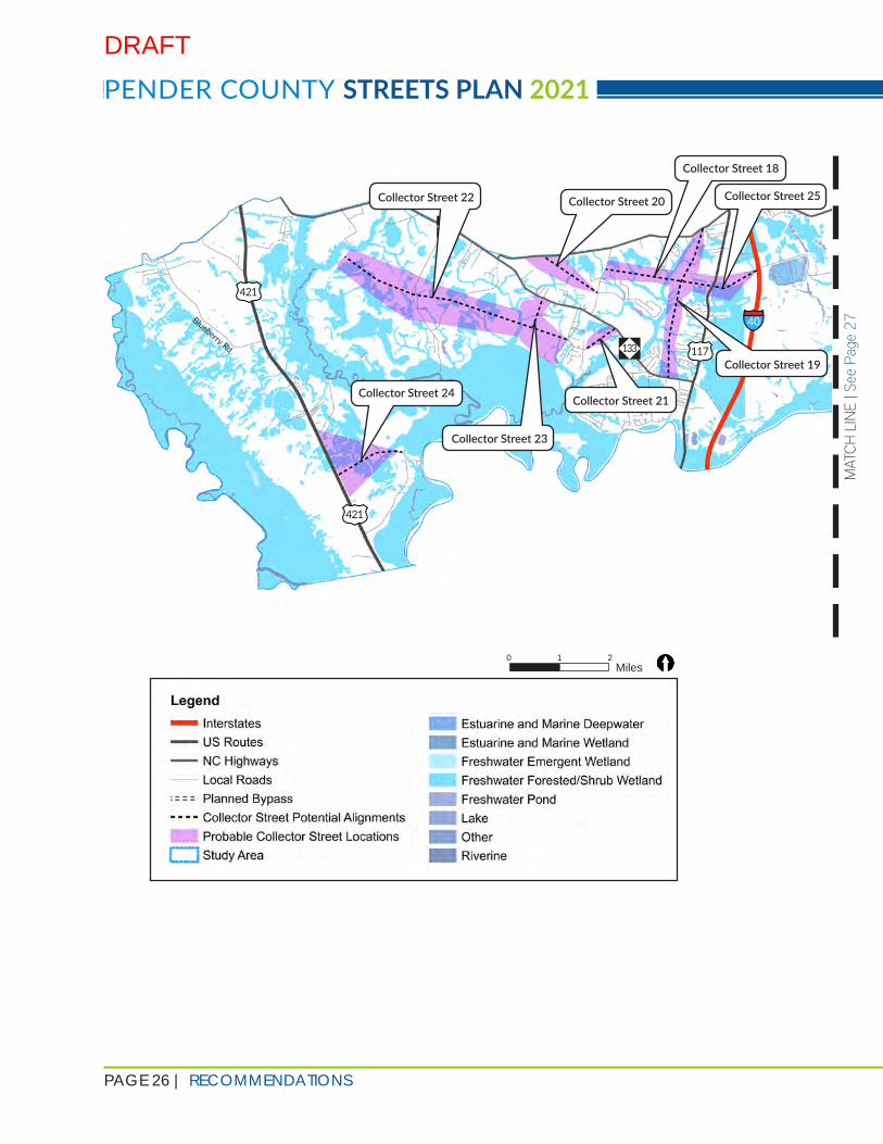
ROADWAY
The proposed updated collector street network consists of 25 collector street recommendations within the study area. In addition to the methodology detailed in the previous section, feedback from the public; input from Pender County Planning and Community Development (Planning Department) and WMPO staffs; and comments and suggestions from stakeholders informed the selection of the proposed collector streets.
An alignment was proposed for each of the recommended collector streets, as well as a general boundary in which the collector street could be aligned. Depending on other constraints and development plans, having a proposed alignment that can then be adjusted inside a certain area provides flexibility when planning for a collector street. All proposed alignments and collector street boundaries were planned so that they
avoided smaller parcels, disruptions to established neighborhoods and communities, major wetland areas, natural areas, and preserved areas. The final set of recommendations is shown in Figure 5-1 on the following pages. Details for individual collector streets are shown in Appendix D.
RECOMMENDATIONS
DRAFT
PAGE 26 | RECOMMENDATIONS
PENDER COUNTY STREETS PLAN 2021
MAT
CH L
INE
| See
Pag
e 27
0 1 2 Miles
40
117
210
421
421
Blueberry Rd. 133
Collector Street 22
Collector Street 18
Collector Street 20 Collector Street 25
Collector Street 19
Collector Street 21
Collector Street 23
Collector Street 24
DRAFT

RECOMMENDATIONS | PAGE 27
These recommendations represent a significant reduction in the mileage of collector streets from the 2016 Pender County Collector Streets Plan (the 2016 Plan), shown in Figure 2-1. The 2016 Plan recommended 245 miles of collector streets while this 2021 Plan Update (the Update) recommends 63 miles of collector streets, which is a reduction of approximately 74%. This was achieved by simplification of tiers, consolidating redundant collector streets, and retaining only the most necessary collector streets based on mathematical calculation of travel demand requirements.
The polygons corresponding to the collector street boundaries are dynamic and their geometries are likely to become more limited as more and more segments of a collector street are constructed. The scenarios on the following pages outline the method of interpretation of the collector street boundaries.
Figure 5-1 | Collector Streets Alignment Recommendations
MAT
CH L
INE
| See
Pag
e 27
MATCH LINE | See Page 26
210
210
Hoover Rd.
17
17
Sloop Point Loop Rd.
Sloop Point Rd.
Collector Street 17
Collector Street 16
Collector Street 2
Collector Street 9
Collector Street 10
Collector Street 11
Collector Street 14
Collector Street 13
Collector Street 15
Collector Street 5 Collector Street 12
Collector Street 8
Collector Street 6
Collector Street 7
Collector Street 4
Collector Street 1
Collector Street 3
DRAFT

PAGE 28 | RECOMMENDATIONS
PENDER COUNTY STREETS PLAN 2021
SCENARIO 2
Figure 5-2 | Polygon Scenario 1 Figure 5-3 | Polygon Scenario 2
The developer of Parcel A has decided to align the collector street in a certain way. Parcel A has confirmed with the Parcel B owner and the Planning Department that the extension of this street into Parcel B would NOT impact an environmental feature that could preclude the construction of the collector street in Parcel B.
Parcel B and C now have a reduced number of alignment options to locate the collector street on their respective parcels since the street will eventually have to connect to the alignment in Parcel A. This is determined by design speeds and local buildability conditions. This results in the shrinking of the polygon as one approaches Parcel A.
A general area has been identified for where a collector street should be aligned. This is represented by the polygon showing all possible alignment options for a particular collector street. Parcels A, B and C represent the parcels through which the collector street needs to be aligned.
In this scenario, no part of the collector street has been constructed in parcels A, B, or C. Whichever parcel develops first can construct the collector street on its parcel with significant leeway in alignment selection as long as it falls within the polygon and it can be extended to the adjacent parcel where the same polygon passes through.
The other parcels will have to tie it into this determined alignment.
SCENARIO 1
DRAFT

RECOMMENDATIONS | PAGE 29
Figure 5-4 | Polygon Scenario 3
During implementation, developers should not be allowed to stub out the collector street in such a way that its extension would be burdensome to the adjacent parcels due to environmental conditions. Additional language strengthening this clause was added to the policy recommendations empowering the Planning Department to ensure overall connectivity can be achieved without disproportionate adverse impacts on any parcel.
Construction of collector streets will necessitate further strengthening of the arterial street network so that the overall roadway network will function at acceptable standards. The travel demand calculations carried out in this Update indicate the improvements listed below would be necessary to maintain acceptable levels of traffic. Detailed evaluation of these improvements should occur in a separate planning effort. Appendix E shows detailed calculations of traffic growth at key locations based on historic Average Annual Daily Traffic (AADT) data from NCDOT and a comparison with the traffic volumes in the Travel Demand Model (TDM).
1. Widening US 17 from 4 lanes to 6 lanes between I-140 and NC 210
2. Widening US 17 from 4 lanes to 6 lanes between NC 50 and US 17 Bypass
3. Widening NC 210 from 2 lanes to 4 lanes between US 17 and Island Creek Road
4. Realigning NC 210 such that it forms a T-junction with Island Creek Road*
5. Constructing an interchange on US 17 Bypass at Sidbury Road*
6. Widening Sidbury Road from 2 lanes to 4 lanes between US 17 and US 17 Bypass
7. Widening NC 210 from 2 lanes to 4 lanes between US 117 and I-40 interchange
*projects included in the WMPO’s adopted Metropolitan Transportation Plan (MTP), Cape Fear Moving Forward 2045
In this scenario, both Parcel A and Parcel C have decided to align the collector street in a certain way within their respective parcels and the collector street polygon. The parcel owners have confirmed that extension of this street into Parcel B would not impact an environmental feature that could preclude the construction of the collector street in Parcel B.
Now Parcel B has two fixed endpoints to honor when aligning the collector street. The developer is still free to determine the internal alignment through Parcel B as long as design standards and road geometries are maintained, and the street eventually connects to the stub-outs in Parcels A and C.
Note: A stub-out is a temporary termination of a street that is intended to be extended through adjacent property in the future. Stub-outs are generally required when it is anticipated that adjacent property will need to extend the street to accommodate future development.
SCENARIO 3
DRAFT
PAGE 30 | RECOMMENDATIONS
PENDER COUNTY STREETS PLAN 2021
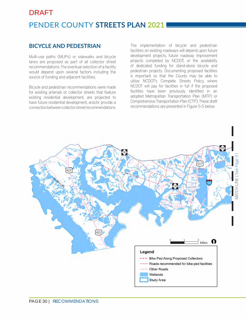
BICYCLE AND PEDESTRIAN
Multi-use paths (MUPs) or sidewalks and bicycle lanes are proposed as part of all collector street recommendations. The eventual selection of a facility would depend upon several factors including the source of funding and adjacent facilities.
Bicycle and pedestrian recommendations were made for existing arterials or collector streets that feature existing residential development, are projected to have future residential development, and/or provide a connection between collector street recommendations.
The implementation of bicycle and pedestrian facilities on existing roadways will depend upon future development projects, future roadway improvement projects completed by NCDOT, or the availability of dedicated funding for stand-alone bicycle and pedestrian projects. Documenting proposed facilities is important so that the County may be able to utilize NCDOT’s Complete Streets Policy, where NCDOT will pay for facilities in full if the proposed facilities have been previously identified in an adopted Metropolitan Transportation Plan (MTP) or Comprehensive Transportation Plan (CTP). These draft recommendations are presented in Figure 5-5 below.
0 1 2 Miles
MAT
CH L
INE
| See
Pag
e 31
MATCH LINE | See Page 30
40
210
117
210
421
421
Blueberry Rd. 133
DRAFT

RECOMMENDATIONS | PAGE 31
Figure 5-5 | Bicycle and Pedestrian Recommendations
MATCH LINE | See Page 30
Island Creek Rd.
210
210
Hoover Rd.
17
17
Count
ry Club
Dr. Sloop Point L
oop Rd.
Sloop Point Rd.
DRAFT

PAGE 32 | RECOMMENDATIONS
PENDER COUNTY STREETS PLAN 2021
TYPE 1A
Collector streets without curb and gutter with an MUP must have a minimum of:
1. Two (2) 11’-wide (minimum) travel lanes going in opposite directions2. Two (2) 4’-wide (minimum) paved shoulders on the far sides of the travel lanes3. 10’-wide (minimum) multi-use path (MUP) on one side of the roadway with additional 2’-wide paved
shoulders on each side of the MUP (resulting in a minimum of 14’ paved surface)4. A minimum clear zone of 20’ between the edge of vehicular travel lane and the interior edge of MUP
This equates to a minimum clear zone of 14’ between the edges of roadway pavement (including paved shoulders) and the interior edge of MUP (including paved buffer)
5. Additional minimum dimensions as shown in Figure 5-6
Figure 5-6 | Street Type 1A: 2-Lane Road with MUP (without Curb and Gutter)
A. WITH MULTI-USE PATH (MUP)
B. WITH SIDEWALK AND BIKE LANES
1. WITHOUT CURB AND GUTTER 1A 1B2. WITH CURB AND GUTTER 2A 2B
Table 5-1 | Types of Street Cross Sections
STREET CROSS SECTIONS
This Update recommends four types of street sections to guide the design of the collector streets in southeastern Pender County. These cross-sections are not intended to be prescriptive, but provide the minimum design standards in accordance with NCDOT design criteria while affording developers flexibility in design aesthetics.
All collector streets recommended in this Update are divided into four main categories. These categories are based on NCDOT Typical Section 2F and should be designed at a minimum of 40 mph design speed (35 mph posted speed). Developers must select one of the types outlined in Table 5-1 below as a starting point which can then be expanded upon. The minimum requirements of each street cross section type are described in the sections following the table.
DRAFT

RECOMMENDATIONS | PAGE 33
TYPE 1B
Collector streets without curb and gutter with bike lanes and sidewalks must have a minimum of:
1. Two (2) 11’-wide (minimum) travel lanes going in opposite directions2. 6’-wide (minimum) bike lanes on both sides of the travel lanes3. 6’-wide (minimum) sidewalks on both sides of the roadway4. A minimum clear zone of 20’ between the edge of vehicular travel lane and the interior edge of
sidewalk. This equates to a minimum clear zone of 14’ between the edges of roadway pavement (including bike lanes) and the interior edge of sidewalk
5. Additional minimum dimensions as shown in Figure 5-7
Developers can add medians, provide wider lanes, wider sidewalks, wider distances between the roadway and the sidewalk or MUP, transit bulb-outs and shelters, and other aesthetic and functional features to these base roadway cross sections. These enhancements are subject to NCDOT review.
Two out of 25 collector streets in this Update (#9 and #10) are recommended to be 4-lane based on the traffic projections. Converting any other roads to 4-lane roads is at the discretion of the developer and the Planning Department. Converting any of the four street cross section types to a 4-lane cross section will necessitate the additional features listed below and must adhere to NCDOT design criteria.
1. For Types 1A and 1B: adding a minimum 23’-wide clear zone in the median with appropriate drainage ditch and a minimum 2’-wide paved shoulder between the innermost lane and the median.
2. For Types 2A and 2B: adding a minimum 18’-wide raised median (with additional 2 ½’ curbs on each side of the median)
NOTE
Figure 5-7 | Street Type 1B: 2-Lane Road with Sidewalks and Bike Lanes (without Curb and Gutter)
DRAFT

PAGE 34 | RECOMMENDATIONS
PENDER COUNTY STREETS PLAN 2021
TYPE 2A
Collector streets with curb and gutter with an MUP must have a minimum of:
1. Two (2) 12’-wide (minimum) travel lanes going in opposite directions2. 2 ½’-wide (minimum) curb and gutter on both sides of paved roadway3. 10’-wide (minimum) multi-use path (MUP) on one side of the roadway with additional 2’-wide paved
shoulders on each side of the MUP (making the total width of the paved surface a minimum of 14’) 4. 8’-wide (minimum) planting area between the curb and the MUP (including paved buffer)5. 8’-wide (minimum) clear zone beyond the curb on the side of the roadway opposite the MUP6. Additional minimum dimensions as shown in Figure 5-8
Figure 5-8 | Street Type 2A: 2-Lane Road with MUP (with Curb and Gutter)
DRAFT

RECOMMENDATIONS | PAGE 35
TYPE 2B
Collector streets with curb and gutter with bike lanes and sidewalks must have a minimum of:
1. Two (2) 11’-wide (minimum) travel lanes going in opposite directions2. 6’-wide (minimum) bike lanes on both sides of the travel lanes3. 2 ½’-wide (minimum) curb and gutter on both sides of paved roadway4. 6’-wide (minimum) sidewalks on both sides of the roadway5. 6’-wide (minimum) planting area between the curbs and the sidewalks6. Additional minimum dimensions as shown in Figure 5-9
Figure 5-9 | Street Type 2B: 2-Lane Road with Sidewalks and Bike Lanes (with Curb and Gutter)
DRAFT

PAGE 36 | RECOMMENDATIONS
PENDER COUNTY STREETS PLAN 2021
POLICY RECOMMENDATIONS
The 2016 Pender County Collector Street Plan (the 2016 Plan) included nine recommendations to be added to the Unified Development Ordinance (UDO) to ensure proper implementation of the Plan. These recommendations were evaluated in order to assess whether they should be retained, modified, or removed from this 2021 Plan Update (the Update).
1| STORMWATER RUNOFF MANAGEMENT
Recommendation: Stormwater BMPs and Green Streets Policies are essential in mitigating pollution and maintaining water quality, particularly in sensitive natural areas. Pender County is home to significant natural resources, which can be negatively impacted by stormwater runoff. To avoid this type of environmental degradation, stormwater BMPs are recommended to be implemented as appropriate to local conditions.
Action: To be carried forward in the Update.
Reason: This recommendation is essential for the preservation of water quality in Pender County.
Additional Notes: Two broad categories of street sections have been developed: one with curb and gutter, and one with a ditch section to provide flexibility to the developers based on availability of water and sewer infrastructure.
2| STREET SPACING STANDARDS
Recommendation: Enact a policy that creates street spacing standards for collector streets to ensure adequate cross access between land uses.
Action: To be removed as a policy recommendation.
Reason: This recommendation was a result of the methodology by which the 2016 Plan was created. The methodology used in this Update does not include standard street spacing criteria, thereby rendering this policy recommendation unnecessary.
Additional Notes: The text of the policy recommendation does not differentiate between local and collector streets. This text should also be removed from the UDO.
DRAFT

RECOMMENDATIONS | PAGE 37
3| TRAFFIC IMPACT ASSESSMENT
Recommendation: A Traffic Impact Assessment (TIA) shall be required if one of the following applies to a specific site plan:
• The development generates 1,000 vehicle trips per day; or• 100 vehicles in the AM or PM peak hour.
Action: To be carried forward in the Update.
Reason: The basis of this policy recommendation was that this requirement already exists in Pender County’s current UDO.
Additional Notes: This threshold is largely consistent with other counties and municipalities throughout North Carolina.
4| NCDOT COMPLETE STREETS
Recommendation: Proposed collector streets as defined by the Collector Street Plan will adhere to the NCDOT Roadway Design Manual, including the design of multimodal facilities – i.e., proposed pedestrian and bicycle facilities must be designed and constructed to the applicable standard.
Action: To be carried over from the 2016 Plan and merged with bicycle and pedestrian facility recommendations. Bicycle and pedestrian facility design criteria will be incorporated into the updated NCDOT Roadway Design Manual anticipated to be released in Summer 2021.
Reason: This Update intends to strengthen the non-motorized network along with the collector street network and this recommendation would help to achieve that goal.
Additional Notes: Additional language added to ascertain transition between two different types of bicycle and pedestrian facilities.
5| ENVIRONMENTAL CONSERVATION POLICY
Recommendation: In order to preserve the unique natural environment in Pender County, any new development that would require the construction of a collector street as defined by the Collector Street Plan, would avoid or minimize impacts to sensitive natural areas, such as wetlands, floodplains, and areas with endangered flora/fauna.
Action: To be carried forward in the Update.
Reason: This recommendation furthers environmental protection, which is in line with the goals of this Update.
Additional Notes: Additional language added to ensure alignment of collector streets on one parcel does not encroach onto environmentally sensitive areas in adjacent parcels when the street could be extended in the future.
DRAFT

PAGE 38 | RECOMMENDATIONS
PENDER COUNTY STREETS PLAN 2021
6| TRI-PARTY AGREEMENT
Recommendation: The Tri-Party agreement is a framework for the construction and maintenance of new pedestrian and bicycle facilities along collector streets.
Action: To be carried forward in the Update.
Reason: Although this recommendation has not yet been implemented, the inclusion of this recommendation provides a pathway for it to be included in future updates of the UDO.
Additional Notes: The inclusion of this recommendation was discussed with Pender County.
7| GENERAL CONNECTIVITY OF COLLECTOR STREETS
Recommendation: Connectivity requires that private entities coordinate across different properties to anticipate future connections between adjacent properties. Providing connectivity to nearby amenities and to the arterial system is important to avoid congestion across the transportation system. This policy requires that new collector roadways be constructed to provide connections between the collector and arterial systems.
Action: To be carried forward in the Update with additional language describing the situations and conditions.
Reason: The basis of this Update is to improve connectivity and this recommendation promotes this.
Additional Notes: This recommendation should be moved further up the list of policy recommendations.
8| BICYCLE AND PEDESTRIAN ACCOMMODATION
Recommendation: All proposed collector streets, as defined by the Collector Street Plan, shall have accommodations for bicycle or pedestrian facilities.
Action: To be carried forward in the Update.
Reason: This Update looks to strengthen the non-motorized network along with the collector street network and this recommendation would help to achieve that goal.
Additional Notes: NCDOT Complete Streets recommendation merged into this recommendation. Additional language added to ascertain transition between two different types of bicycle and pedestrian facilities within one development and across adjacent developments.
DRAFT

RECOMMENDATIONS | PAGE 39
9| REDUCED PAPER STREETS
Recommendation: Encourage the construction of paper streets to the greatest extent possible; reduce the number and extent of paper streets.
Action: To be carried forward in the Update.
Reason: There are a few paper streets in the study area which need to be honored by new developments.
Additional Notes: Retention of this recommendation and the strengthening of it may result in developers planning subdivisions that take paper streets into consideration.
POLICY STRATEGIES
The following tables provide information for the policy measures recommended by this Update.
NOTE: The Planning Department should consult with the County’s attorney before any or all of the sample language on the following pages is added to the UDO.
CONNECTIVITY AND CONTIGUITY OF COLLECTOR STREETS
Description/Purpose
Connectivity requires that private entities coordinate across different properties to anticipate future connections between adjacent properties. Providing connectivity to nearby amenities and to the arterial system is important to avoid congestion across the transportation system. This policy requires that new collector streets be constructed to provide connections between the collector and arterial systems.
As new development is programmed, this policy would require that collector streets are not closed off, but are “stubbed out” to ensure that future roadway construction can tie back into the public roadway network. Essentially, this policy stipulates that no collector street can dead end.
In addition to the contiguity of collector streets, this policy is also designed to ensure contiguity of bicycle and pedestrian infrastructure.
Target Performance
Measure
Each new development needs to provide connections to another collectoror arterial, or shall provide a signed stub-out to allow future connections as new development occurs. All practical connections must be included.
No collector street should be discontinued without signage (i.e., Future Connection)
DRAFT

PAGE 40 | RECOMMENDATIONS
PENDER COUNTY STREETS PLAN 2021
CONNECTIVITY AND CONTIGUITY OF COLLECTOR STREETS
Sample Language All recommended collector streets have been designed in anticipation of future growth and connectivity requirements of the area. For each collector street recommendation, there is a corresponding polygon representing the boundaries of possible alignments.
All new developments in the parcels that contain the collector street polygons are required to build collector streets unless the requirement has been waived by Pender County Planning and Community Development (Planning Department). The Planning Department shall evaluate the proposals of waiver and shall provide waivers based on their assessment keeping in mind the following criteria:
1. Redundancy: A collector street segment located on adjacent parcel has fulfilled the connectivity intent in such a way that constructing it on the parcel in question will create a parallel redundant collector street.
2. Discontinuity: An adjacent parcel has constructed a collector street that does not stub-out to the parcel in question and hence constructing it on the parcel in question will create a discontinuous segment of the collector street.
3. Futility: There is no possibility of a future connection between the parcel in question and another discrete segment of the same collector street even with a bridge, or other structure and hence constructing it on the parcel in question will be futile.
4. Impossibility: If a large portion of the parcel is unbuildable because of local environmental features, it may not be possible to appropriately route the collector street in that parcel.
In cases where a section of the collector street polygon passes through multiple parcels of land in such a way that the collector street can be aligned on any of those parcels without compromising the overall connectivity intent, the Planning Department shall decide which parcel is most appropriate to route that collector street. The following criteria must be kept in mind while making that decision:
1. Road geometry. 2. Local environmental and buildability conditions.3. Relative parcel sizes and assessment of undue disadvantage to smaller parcels.
A collector street shall be located within the corresponding polygon and shall connect to any one of the following:
1. Adjacent land at a location that allows the continuation of the collector street onto the adjacent property as a temporary stub-out.
2. Another collector street or another, higher-level (e.g., arterial) street.3. At least two local streets in case a collector street ends in a property without a
recommended connection to either adjacent property or a higher-level street. This connection can be made using an intersection or a roundabout with 3 local streets, a Y-junction, T-junction, or a roundabout with two local streets. Collector streets cannot transition into only one local street.
DRAFT

RECOMMENDATIONS | PAGE 41
CONNECTIVITY AND CONTIGUITY OF COLLECTOR STREETS
Sample Language, continued
In instances where the collector street cannot be constructed in its entirety, a temporary turnaround at the end of the street, which shall be reviewed and approved by NCDOT, is required.
Stub-outs shall be adequately signed at the time of final plat recordation, with an easement recorded to the adjacent parcel, and their existence shall be noted on all subdivision plats and deed documents.
The alignment of a collector street shall be such that its continuation to the adjacent parcel does not encounter environmental features (floodplains, wetlands etc.) that can create a barrier for the continuation of the street in future. The Planning Department shall be empowered to disallow any collector street alignment that can cause an avoidable undue burden to the adjacent parcel (stream crossing, environmental mitigation, etc.). This may require coordination with owners of adjacent parcels and the Planning Department.
All plat drawings shall indicate the extents of the collector street polygons if any part of a polygon is located on any of the parcels for which the plat drawings are prepared.
Additional Notes The Planning Department should weigh the burden on each parcel against the overall goal of connectivity and make the appropriate decision. While it is easy to prescribe a roadway alignment for an area, it is impossible to evaluate each parcel at a planning level to determine exact alignment and hence, a case-by-case analysis becomes important. It is equally important to achieve connectivity goals while avoiding undue burden to small, more vulnerable parcels. This does not mean that all smaller parcels get a waiver from the requirement that collector streets be routed through them, but that all options should be evaluated before a decision is made.
DRAFT

PAGE 42 | RECOMMENDATIONS
PENDER COUNTY STREETS PLAN 2021
CONNECTIVITY AND CONTIGUITY OF LOCAL STREETS
Description/Purpose
When neighborhoods lack sufficient local street connectivity to adjacent parcels in all directions, they increase travel distances and force all trips through collector streets. These artificially inflated travel distances increase traffic while making it impractical to walk or bike. Higher connectivity also reduces emergency response times.
The most effective way to improve local connectivity is to encourage smaller block sizes, which in turn can be achieved by minimizing cul-de-sacs and encouraging street connections to adjacent parcels. Cut-through traffic can be discouraged by traffic-calming and slowing measures. Cul-de-sacs must be required to provide through connections for bicycles and pedestrians.
Current regulations stipulate that for a development with more than 30 units, at-least two access roads are required. This requirement should be expanded in such a way that for single family residential, each additional number of units of a certain multiple requires one additional access road be provided.
Contiguity of the local streets will also ensure contiguity of bicycle and pedestrian infrastructure. Based on local conditions, if a two-way local street is not feasible, a minimum connection should be provided to ensure bicycle and pedestrian network contiguity.
Target Performance
Measure
Each new development needs to provide local street connections to all adjacent parcels wherever feasible or shall provide a signed stub-out to allow future connections as new development occurs. All practical connections must be included.
Local street connections to adjacent properties shall be provided such that a block length of 1500 feet in low density areas, 1000 feet in medium density areas and 500 feet in high density areas is maintained.
No local street should be discontinued without signage (i.e., Future Connection)
Sample Language A network of interconnected streets providing both external and internal connectivity is required for all types of new development. This network can be constructed with either public streets or private streets as allowed.
All existing street stub-outs from adjacent developments shall be extended into the development with proper road geometry. Continuation of such streets through the development is encouraged, and ending these streets with a T-junction or a T-junction with a cul-de-sac across is discouraged.
DRAFT

RECOMMENDATIONS | PAGE 43
CONNECTIVITY AND CONTIGUITY OF LOCAL STREETS
Sample Language, continued
A block is defined as a piece of land bounded by roads on all sides. Recommended block length for residential land uses is as follows:
≤1 dwelling unit per acre 1,500 feet>1 and ≤4 dwelling units per acre 1,000 feet>4 dwelling units per acre 600 feet
Additional new local street connections shall be required to ensure that the overall block dimensions of the region adhere to the dimensions listed above.
Measure the length of each property boundary and divide by the appropriate preferred block length spacing to determine the overall number of blocks required along that boundary. Round down to the nearest whole number. This is the required number of block faces along that boundary. Where the result is less than two but the property line length exceeds the recommended block length, one street is required.
Where an odd-shaped parcel has a series of boundary segments shorter than the preferred block length, but separate blocks would be required if the site is measured across (as opposed to along the boundary segments), then a local street shall be required. Where the extension of non-local and adjacent local streets creates a street network that meets the required number of blocks, no additional new streets are required. If the distance from the nearest adjacent street to the parcel boundary exceeds the maximum block length, then a street may be required.
If any property boundary abuts an environmental feature where any connection to the adjacent parcel is not feasible, the block length requirements may be relaxed by explicit consent of the Planning Department.
Construct new local streets where additional streets are required to create the blocks calculated above, including any required stub streets or half streets. When the property abuts a local street, begin by aligning, where possible, with streets or driveways across the local street to create four-way intersections.
DRAFT

PAGE 44 | RECOMMENDATIONS
PENDER COUNTY STREETS PLAN 2021
CONNECTIVITY AND CONTIGUITY OF LOCAL STREETS
Sample Language, continued
Stub-outs shall be adequately signed at the time of final plat recordation, with an easement recorded to the adjacent parcel, and their existence shall be noted on all subdivision plats and deed documents.
In cases where the existing development in an adjacent parcel completed construction before financial year 2021, and a planned stub-out was not constructed up to the property line of the adjacent parcel, the developer must build the portion of the stub-out in the adjacent parcel up to the common parcel boundary so that there is no gap between the previous stub-out and its extension to the proposed development. The street connecting to the stub-out in the adjacent parcel should be constructed such that vehicles, and non-motorized modes, do not experience a gap in pavement while going from one development to another using the said street.
Once the external streets are created, they should be connected internally, and a network should be created in a way that the average of the block lengths for the entire site does not exceed the recommended block length listed above.
Cul-de-sacs should be discouraged since they increase the overall block length. The maximum permissible length of a cul-de-sac is 500 feet.
The alignment of the local streets shall be such that its continuation to the adjacent parcel does not encounter environmental features (floodplains, wetlands etc.) that can create a barrier for the continuation of the street in future. The Planning Department shall be empowered to disallow any local street alignment that can cause an avoidable undue burden to the adjacent parcel (stream crossing, environmental mitigation, etc.). This may require coordination with owners of adjacent parcels and the Planning Department.
Additional Notes If a collector street passes through a parcel, some of these requirements may be relaxed by the Planning Department after assessing the overall impacts to connectivity in the area.
TRAFFIC IMPACT ASSESSMENT REQUIREMENT
Description/Purpose
NCDOT requires that Traffic Impact Assessments (TIAs) be conducted for developments forecast to generate 3,000 vehicle trips per day (vpd). Pender County requires a lower threshold, 100 vehicle trips during the AM or PM peak hour or 1,000 vpd. This policy ensures that the arterial system in Pender County is not unduly burdened without understanding the impacts of the proposed development to the existing system.
DRAFT

RECOMMENDATIONS | PAGE 45
TRAFFIC IMPACT ASSESSMENT REQUIREMENT
Target Performance
Measure
Require new developments forecasted to generate over 100 trips during the AM or PM Peak hour or 1,000 vpd to conduct a TIA.
The TIA is a useful assessment tool that can have an expanded range and different levels of considerations to make it more suitable for use on collector streets. TIA reports are a critical part of the development review and approval process, as they are the primary tool for identifying the potential net effects from a development proposal. The standard 1,000 vpd threshold that can trigger a TIA represents a significant fraction (8%- 10%) of the total capacity of a collector street. A significant increase in traffic on a collector street can reduce functional integrity and public purpose. A traffic study should consider all modes of travel including vehicles, transit, bicyclists, and pedestrians.
Sample Language A Traffic Impact Assessment (TIA) shall be required if one of the following applies to a specific site plan:
1. The development generates 1,000 vehicle trips per day (vpd); or2. 100 vehicles in the AM or PM peak hour.
This requirement applies to all phases of a proposed development. Other stipulations regarding internal capture, trip generation, trip distribution, and peak hour factors will be part of the basic requirements of the TIA. It is recommended to assess and quantify the cumulative impact to the roadway network and establish processes to address additional traffic created as a result of additional development.
Additional Notes With substantial development likely to occur in the study area in the next decades, establishing robust measures to ensure that back access is created to new developments along US 17 is of paramount concern. Traffic is already high on US 17 and the provision of multiple developments without adequate cross-access to other roadways in the area will only worsen existing traffic issues. This measure is a requirement.
DRAFT
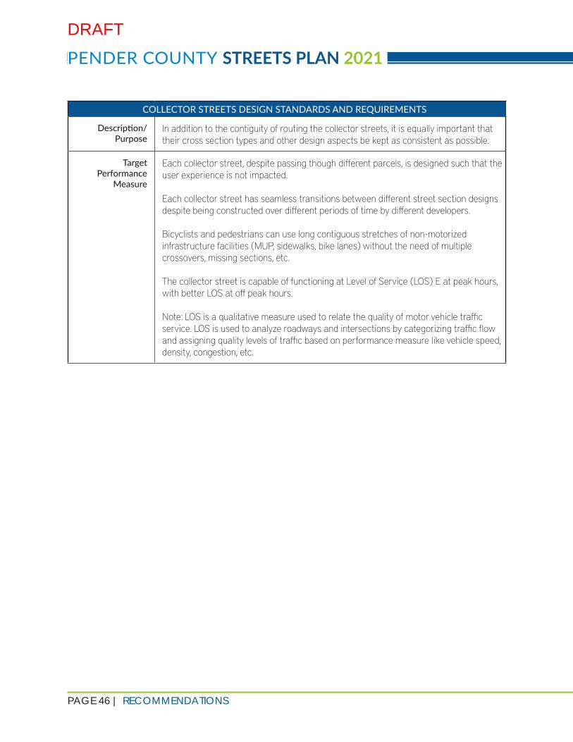
PAGE 46 | RECOMMENDATIONS
PENDER COUNTY STREETS PLAN 2021
COLLECTOR STREETS DESIGN STANDARDS AND REQUIREMENTS
Description/Purpose
In addition to the contiguity of routing the collector streets, it is equally important that their cross section types and other design aspects be kept as consistent as possible.
Target Performance
Measure
Each collector street, despite passing though different parcels, is designed such that the user experience is not impacted.
Each collector street has seamless transitions between different street section designs despite being constructed over different periods of time by different developers.
Bicyclists and pedestrians can use long contiguous stretches of non-motorized infrastructure facilities (MUP, sidewalks, bike lanes) without the need of multiple crossovers, missing sections, etc. The collector street is capable of functioning at Level of Service (LOS) E at peak hours, with better LOS at off peak hours.
Note: LOS is a qualitative measure used to relate the quality of motor vehicle traffic service. LOS is used to analyze roadways and intersections by categorizing traffic flow and assigning quality levels of traffic based on performance measure like vehicle speed, density, congestion, etc.
DRAFT

RECOMMENDATIONS | PAGE 47
COLLECTOR STREETS DESIGN STANDARDS AND REQUIREMENTS
Sample Language All collector streets must be designed at a minimum of 40mph design speed (35 mph posted speed). This includes curvatures, signage distances, lane tapers and all other engineering requirements as required by NCDOT. Additional traffic studies may be required to determine whether auxiliary turning lanes should be provided at the intersections with local, collector, or arterial roads.
Driveways and intersections should be no less than 500 feet apart unless there is/are parcel(s) that will not have feasible access to another roadway besides the collector street. The Planning Department will review these instances on a case-by-case basis and will work with developers to ensure that the majority of driveways will primarily be accessed by local streets.
All collector streets must meet the minimum design standards of at least one of the four street cross section types detailed in the Collector Street Plan. Should the developer choose to go beyond the minimum street cross section design criteria, the street cross sections should appropriately transition back to the minimum design standards (of the appropriate street cross section type) at the stub-outs to avoid undue burden to the adjacent parcels.
The collector streets shall be continued from stub-outs of adjacent parcels using the same cross section design as the stub-out, which shall not deviate from one of the four street cross section types shown in the “Street Cross Sections” portion of the Collector Street Plan.
For any collector street, the street cross section changes that necessitate transitions between MUP on one side and sidewalks and bicycle lanes on both sides shall be kept to a minimum to provide seamless access to cyclists and pedestrians with minimal crossovers. Such transitions, if required, shall be encouraged at collector-collector and collector-arterial intersections. Such transitions shall be avoided at collector-local intersections.
High-visibility crosswalks built to NCDOT standards with proper Americans with Disabilities (ADA) accommodations shall be provided at all collector-local, collector-collector, and collector-arterial intersections.
Additional Notes Strengthening the non-motorized infrastructure may result in people switching from cars to other modes for short trips. The key is well-maintained, seamless, and safe pedestrian and bicycle infrastructure.
DRAFT

PAGE 48 | RECOMMENDATIONS
PENDER COUNTY STREETS PLAN 2021
BICYCLE AND PEDESTRIAN ACCOMMODATION WITH NCDOT COMPLETE STREETS GUIDELINES
Description/Purpose
As Pender County develops, the demand for safe, comfortable bicycle and pedestrian facilities will continue to increase. This policy requires the accommodation of non-motorized users along collector streets, particularly in areas close to residential developments, schools, or parks. The network of facilities for pedestrians and bicyclists will become a high-quality amenity in the County. Beyond health- and mobility-related benefits, one additional advantage of accommodations for bikes/pedestrians is preservation of capacity along the roadways with reduced vehicular use (active modes of transportation).
The NCDOT Roadway Design Manual (anticipated summer 2021 release) provides guidance on the design and construction of streets that accommodate all users of the transportation system, including bicyclists, pedestrians, transit users, and motorists. This policy would require implementing a Complete Streets approach in new street design and construction in areas where bicycle and pedestrian amenities are programmed in the adopted Collector Street Plan.
Target Performance
Measure
Connect key destinations, including schools, parks, commercial centers, and residential developments with pedestrian and bicycle amenities.
Proposed collector streets should be designed to Complete Streets standards to accommodate pedestrians and bicyclists when these facilities are recommended in the adopted Collector Street Plan.
Sample Language All recommended collector streets, as defined in the adopted Collector Street Plan, shall have accommodations for bicycle or pedestrian facilities.
Requirements for bicycle or pedestrian facilities will be made in accordance with the design criteria outlined in the Collector Street Plan. Any deviation from the aforementioned designs shall adhere to the minimum bicycle and pedestrian infrastructure design standards specified by NCDOT. Other bicycle and pedestrian facilities will be considered if required by existing planning documents.
Proposed collector streets as defined by the Collector Street Plan will adhere to the NCDOT Roadway Design Manual, including the design of multimodal facilities – i.e., proposed pedestrian and bicycle facilities must be designed and constructed to the applicable standard.
The contiguity of the type of bicycle and pedestrian facilities shall be maintained in accordance to the requirements outlined in the “Connectivity and Contiguity of Collector Streets” section of the policy recommendations.
DRAFT

RECOMMENDATIONS | PAGE 49
BICYCLE AND PEDESTRIAN ACCOMMODATION WITH NCDOT COMPLETE STREETS GUIDELINES
Additional Notes The inclusion of sidewalks/pedestrian paths/bikeways on all collector streets should be viewed as a required minimum standard.
This measure is based on a stated desire from the public and other adopted plans in the County to include more pedestrian and bicycle facilities along roads in the Collector Street Plan study area. Construction of new roadways or upgrades to existing roadways should be to the standards indicated in the NCDOT Roadway Design Manual and in this Update.
STORMWATER/GREEN STREETS POLICY REQUIREMENT
Description/Purpose
Stormwater and Green Streets Policies can help ensure stormwater Best Management Practices (BMPs) are implemented, safeguarding precious natural resources, ensuring water quality, and preventing infrastructure maintenance issues. Both NCDOT and the North Carolina Department of Natural and Cultural Resources (DNCR) provide guidance regarding stormwater BMPs. In Pender County, shellfish habitat can be negatively affected as nutrient rich runoff from roads and other impervious surfaces enters streams, rivers, and wetlands. Safely treating stormwater runoff is important in terms of maintaining critical wildlife habitats and ensuring water quality for plant, animal, and human uses.
Target Performance
Measure
Pender County will implement a community education campaign regarding the importance of stormwater mitigation; develop a stormwater management master plan with a focus on the reduction of runoff volumes (as stated in Pender 2.0: Comprehensive Land Use Plan); and explore the possibility of providing incentives to developers for providing stormwater BMPs which will enhance the standard level of treatment. All provisions should be developed and articulated in the Stormwater Management Master Plan.
Sample Language Stormwater BMPs and Green Streets Policies are essential in mitigating pollution and maintaining water quality, particularly in sensitive natural areas. Pender County is home to notable natural resources, which can be negatively impacted by stormwater runoff. To avoid this type of environmental degradation, the implementation of stormwater BMPs is recommended to be implemented as appropriate.
Additional Notes This measure ensures a rigorous implementation of stormwater BMPs and establishes a regulatory framework to require stormwater BMPs where appropriate. Providing stormwater BMPs around critical surface waters and watershed areas can help mitigate water quality issues.
DRAFT

PAGE 50 | RECOMMENDATIONS
PENDER COUNTY STREETS PLAN 2021
ENVIRONMENTAL CONSERVATION POLICY
Description/Purpose
Extending outward from the need to create interconnected populations (streets and greenways) and a reduced footprint from water quality/quantity impacts is the desire to create interconnected ecologies. This practice is called “landscape ecology,” a subset of conservation biology which requires the consideration of green space interconnectivity to provide habitat for species, green spaces for people, and the preservation of the rural character that is valued in Pender County. Large, protected areas like parks and preservation zones need to be connected with “stepping stone” areas that allow the movement of wildlife and promotion of biodiversity.
It is recommended to develop a “Greenprint” that shows areas that would be preserved based on utility (or lack thereof) to private development; linkages to large, protected areas; and biologically diverse habitat (e.g., streams, older-growth forests).
Future developments would incorporate these green areas into their plans as part of open space requirements; additional space provisions could be rewarded through clustering bonuses that allow a higher intensity of development elsewhere on the site.
Target Performance
Measure
Avoid sensitive natural areas to the degree possible when programming new development or reserving road right-of-way (ROW).
Sample Language In order to preserve the unique natural environment of Pender County, any new development that would require the construction of collector streets as defined by the adopted Collector Street Plan, shall avoid or minimize impacts to sensitive natural areas, such as wetlands, floodplain, and areas with endangered flora/fauna. Additional justification (i.e., Corps Delineation, etc.) or other additional resources may be necessary.
Additional Notes In some cases, development will necessarily encroach into sensitive natural areas. Avoiding these areas is strongly recommended, but may not always be feasible or even desirable to do so.
TRI-PARTY AGREEMENT
Description/Purpose
The Tri-Party agreement is a framework for the construction and maintenance of new pedestrian and bicycle facilities along collector streets. While NCDOT would ultimately maintain the street, all maintenance and liability costs for the construction and maintenance of pedestrian and bicycle facilities would be borne by Pender County or the Homeowner’s Association (HOA) until construction was complete. At that point, maintenance would be transferred to the HOA or other qualified party, absolving both NCDOT and Pender County from any liability or maintenance relating to the pedestrian and bicycle amenity.
DRAFT

RECOMMENDATIONS | PAGE 51
TRI-PARTY AGREEMENT
Target Performance
Measure
Negotiate and implement the Tri-Party agreement with NCDOT. (See Appendix F)
Inform affected development community/HOA that this agreement may be warranted for specific situations related to the implementation of bicycle or pedestrian facilities.
Sample Language NCDOT may maintain the multimodal (bicycle and pedestrian) facilities if the following conditions are met:
1. NCDOT’s local Division agrees on the facility design to ensure that they are able to maintain it after construction.
2. It is located in an unincorporated area 3. Developer is turning the ownership of the road with multimodal facilities over to
NCDOT 4. Multimodal facilities are within the NCDOT ROW post handover. These conditions were inferred from the NCDOT Complete Streets Implementation Guide and conversations with NCDOT. Multimodal facility maintenance on collector streets will need to be decided on a case by case basis.
For facilities that do not meet these conditions, details of the tri-party agreement can be seen Appendix F.
Additional Notes The Tri-Party Agreement is fundamental to constructing and maintainingpedestrian and bicycle amenities in the study area. Implementing and abiding by this agreement would be a requirement in situations where bicycle and pedestrian amenities are planned to be constructed.
REDUCED PAPER STREETS
Description/Purpose
A paper street is a “street shown on a recorded plan but never built on the ground” (Shapiro v. Burton, 23 Mass. App. Ct. 327, 328, 1987). These anticipated roads are shown in planning documents or on plats currently on record.
This policy requires that platted ROW becomes built to NCDOT standards to ensure connectivity is implemented.
Target Performance
Measure
Encourage the construction of existing paper streets to the greatest extent possible; reduce the number and extent of new paper streets.
DRAFT

PAGE 52 | RECOMMENDATIONS
PENDER COUNTY STREETS PLAN 2021
REDUCED PAPER STREETS
Sample Language All platted site plans must honor paper streets, reserving ROW and ensuring that streets can be constructed to NCDOT standards. Paper streets must be preserved until such time as they are constructed.
Changing or realigning paper streets will require the developer to obtain all required permissions from the owners of all the parcels that are affected by the changes proposed by the developer.
Additional Notes Proper ROW preservation/width is needed to ensure implementation of an adequate street system with the appropriate non-motorized facilities.
CONCLUSION
The recommendations presented in this document are based on a thorough analysis of Pender 2.0: Comprehensive Land Use Plan, the existing built and natural environment, and stakeholder and public input. These recommendations are purposefully developed to provide flexibility to both Pender County and the development community to build a safe and efficient multimodal transportation network while recognizing the constraints present within individual parcels, adjacent development, and natural resources.
DRAFT


![Heidelberg Road Corridor...2020/02/04 · HIDLBRG ROAD CRRIDR LCAL ARA PLAN DRAT] 5 DRAT Contents Acknowledgement 2 Glossary and Acronyms 3 Contents 5 What is the Heidelberg Road](https://static.documents.pub/doc/80x56/610f2e6123c6e06c336dc1b9/heidelberg-road-corridor-20200204-hidlbrg-road-crridr-lcal-ara-plan-drat.jpg)