17 June 2020 DRILLING RETURNS WIDE HIGH-GRADE GOLD EXTENSIONS AT DIAMBA SUD Chesser Resources Limited (“Chesser” or “the Company”; ASX:CHZ) is pleased to provide the following drilling results from its flagship Diamba Sud Gold Project in Senegal, west Africa. HIGHLIGHTS AREA A • Two high-grade gold structures identified and confirmed over 250m strike length. Significant results include: Eastern Structure: ▪ 23m at 3.50 g/t gold from 96m, including ▪ 6m at 5.44 g/t gold from 96m, and ▪ 6m at 5.60 g/t gold from 110m Western Structure: ▪ 15m at 3.39 g/t gold from 117m and ending in mineralisation • Additional high-grade intercepts from within the existing Area A footprint include: ▪ 8m at 2.90 g/t gold from 0m (oxide) ▪ 12m at 3.86 g/t gold from 14m (oxide), including ▪ 4m at 10.67 g/t gold ▪ 15m at 2.98 g/t gold from 72m, including ▪ 4m at 7.35 g/t gold from 80m ▪ 24m at 3.29 g/t gold from 94m, including ▪ 8m at 6.81 g/t gold from 95m • Two drill lines testing the southeast extension of Area A intersected alteration and sulphides in the host structure trending towards Barrick’s adjoining Bambadji JV area. • 12 holes (for 1,185m) of the 4,000m Phase 4 drill program reported to date with an estimated 2,800m of drilling expected to be completed by the end of June. “We are delighted to report that the first batch of drilling results have confirmed and extended two high-grade mineralised structures at Area A within our Diamba Sud Gold Project. These new results continue to grow the scale and improve our understanding of the structural controls of this significant gold discovery. We look forward to updating the market on our progress for the remainder of the program as results become available.” commented Mike Brown, Managing Director and CEO of Chesser Resources. For personal use only
Transcript
17 June 2020
DRILLING RETURNS WIDE HIGH-GRADE GOLD EXTENSIONS AT DIAMBA SUD
Chesser Resources Limited (“Chesser” or “the Company”; ASX:CHZ) is pleased to provide the
following drilling results from its flagship Diamba Sud Gold Project in Senegal, west Africa.
HIGHLIGHTS
AREA A
• Two high-grade gold structures identified and confirmed over 250m strike length.
Significant results include:
Eastern Structure:
▪ 23m at 3.50 g/t gold from 96m, including
▪ 6m at 5.44 g/t gold from 96m, and
▪ 6m at 5.60 g/t gold from 110m
Western Structure:
▪ 15m at 3.39 g/t gold from 117m and ending in mineralisation
• Additional high-grade intercepts from within the existing Area A footprint include:
▪ 8m at 2.90 g/t gold from 0m (oxide)
▪ 12m at 3.86 g/t gold from 14m (oxide), including
▪ 4m at 10.67 g/t gold
▪ 15m at 2.98 g/t gold from 72m, including
▪ 4m at 7.35 g/t gold from 80m
▪ 24m at 3.29 g/t gold from 94m, including
▪ 8m at 6.81 g/t gold from 95m
• Two drill lines testing the southeast extension of Area A intersected alteration and
sulphides in the host structure trending towards Barrick’s adjoining Bambadji JV area.
• 12 holes (for 1,185m) of the 4,000m Phase 4 drill program reported to date with an
estimated 2,800m of drilling expected to be completed by the end of June.
“We are delighted to report that the first batch of drilling results have confirmed and extended two high-grade
mineralised structures at Area A within our Diamba Sud Gold Project. These new results continue to grow the
scale and improve our understanding of the structural controls of this significant gold discovery. We look forward
to updating the market on our progress for the remainder of the program as results become available.”
commented Mike Brown, Managing Director and CEO of Chesser Resources.
For
per
sona
l use
onl
y
Page 2 of 15
March 2019
17 June 2020
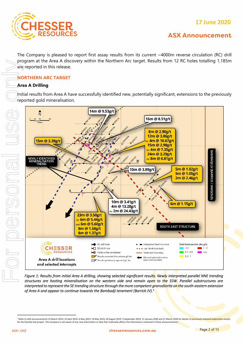
The Company is pleased to report first assay results from its current ~4000m reverse circulation (RC) drill
program at the Area A discovery within the Northern Arc target. Results from 12 RC holes totalling 1,185m
are reported in this release.
NORTHERN ARC TARGET
Area A Drilling
Initial results from Area A have successfully identified new, potentially significant, extensions to the previously
reported gold mineralisation.
Figure 1: Results from initial Area A drilling, showing selected significant results. Newly interpreted parallel NNE trending structures are hosting mineralisation on the western side and remain open to the SSW. Parallel substructures are interpreted to represent the SE trending structure through the more competent granodiorite on the south-eastern extension of Area A and appear to continue towards the Bambadji tenement (Barrick JV).1
1 Refer to ASX announcements 25 March 2019, 10 April 2019, 6 May 2019, 14 May 2019, 26 August 2019, 3 September 2019, 21 January 2020 and 21 March 2020 for details of previously released exploration results for the Diamba Sud project. The Company is not aware of any new information or data that materially affects the information contained in those announcements.
For
per
sona
l use
onl
y
Page 3 of 15
March 2019
17 June 2020
New NNE Mineralised Structural Trend
Drilling has confirmed the presence of a potentially significant structural trend. Hole DSR144 intersected a
wide zone of gold mineralisation along an interpreted north-northeast trend previously reported to the north
in holes DSR115 (10m at 3.41 g/t and 4m at 13.28 g/t gold)2 and DSR127 (10m at 3.89 g/t gold)3 (Figure
1).
Figure 2: Section 360N looking north, showing mineralised zone (the Eastern NNE structure) within altered sedimentary breccia underlying a felsic intrusive.
Gold mineralisation is hosted within altered sedimentary breccias underlying a felsic intrusive (Figure 2) and
is characterised by pyrite mineralisation associated with albite-carbonate-hematite alteration, typical of the
assemblages found associated with other tier 1 gold deposits along the SMSZ orogenic gold belt. Significant
intersections include:
2 Refer to ASX announcement 21 January 2020. The Company is not aware of any new information or data that materially affects the information contained in those announcements. 3 Refer to ASX announcement 2 March 2020. The Company is not aware of any new information or data that materially affects the information contained in those announcements.
For
per
sona
l use
onl
y
Page 4 of 15
March 2019
17 June 2020
• 23m at 3.50 g/t gold from 96m, including
o 6m at 5.44 g/t gold from 96m, and
o 6m at 5.60 g/t gold from 110m
• 8m at 1.58 g/t gold from 127m
• 8m at 1.37 g/t gold from 147m
The host structure and associated gold mineralisation remains open to the south-southwest and is a priority
target for follow-up drilling.
Hole DSR138 was drilled under and potentially down-dip of the gold mineralisation previously reported in
hole DSR112 (10m at 1.90 g/t gold from 78m and 9m at 1.84 g/t gold from 90m)4 within the felsic intrusive
(Figures 1 and 3). The hole successfully intersected 15m at 3.39 g/t gold from 117m within an altered
sedimentary breccia, with the hole ending in mineralisation.
Figure 3: Section 510N, showing mineralised zone representing the western NNE structure intersected in DSR138 (ending in mineralisation). Hole DSR135, drilled to the SW and passing through the section, confirmed the alteration and high-grade mineralisation encountered in previous drilling.5
4 Refer to ASX announcement 21 January 2020. The Company is not aware of any new information or data that materially affects the information contained in those announcements. 5 Refer to ASX announcements 26 August 2019 and 21 January 2020 for details of previously released exploration results for the Diamba Sud project. The Company is not aware of any new information or data that materially affects the information contained in those announcements.
For
per
sona
l use
onl
y
Page 5 of 15
March 2019
17 June 2020
The gold mineralisation appears related to a potential steep, east-dipping structure trending sub-parallel to
the interpreted north-northeast structure intersected in holes DSR144, DSR115 and DSR127 to the immediate
east. Further drilling is required to confirm the potential of this new mineralised structure.
Area A
Two further holes (DSR135 & 136) were drilled within the existing Area A footprint perpendicular to the
interpreted southeast-trending structure hosting the previously reported high-grade mineralisation (Figure
1). Hole DSR135 intersected altered sedimentary breccias and minor carbonates within a wide alteration zone
extending from a downhole depth of 70m to 117m (Figure 3). Significant intersections include:
• 8m at 2.90 g/t gold from 0m (oxide)
• 12m at 3.86 g/t gold from 14m (oxide), including
o 4m at 10.67 g/t gold
• 15m at 2.98 g/t gold from 72m, including
o 4m at 7.35 g/t gold from 80m
• 24m at 3.29 g/t gold from 94m, including
o 8m at 6.81 g/t gold from 95m
Hole DSR136 drilled ~50m along strike to the northwest intersected two alteration zones from downhole
depths of 77m to 85m and 109m to 124m hosted in sedimentary breccia. Neither zone returned any significant
gold mineralisation with a detailed review of the geology being undertaken to better understand potential
controls to the high-grade gold mineralisation.
Southeast Extension Zone
Two lines were completed to the southeast of Area A testing for extensions of the interpreted southeast-
trending structure at Area A (Figure 1). A number of altered zones with sulphides (pyrite) were intersected
within a granodiorite intrusive confirming the continuation of this mineralised structure. Hole DSR134
intersected a broad zones of moderate pyrite mineralisation, which included:
• 5m at 1.02 g/t gold from 64m
• 5m at 1.05 g/t gold from 70m
• 2m at 2.46 g/t gold from 78m
Hole DSR143 intersected 6m at 1.15 g/t gold from 34m indicating potential for multiple sub-parallel
structures (Figure 1). This trend is interpreted to continue towards and correlate with the structure identified
by Barrick with the Bambadji JV to the immediate east of Diamba Sud (Figure 4).
Four additional holes are planned as part of the current drill program, targeting the area between the
Southeast Extension Zone and the Area A footprint, to further test the potential of the interpreted southeast-
trending structure and the eastern extension of the sedimentary breccias.
For
per
sona
l use
onl
y
Page 6 of 15
March 2019
17 June 2020
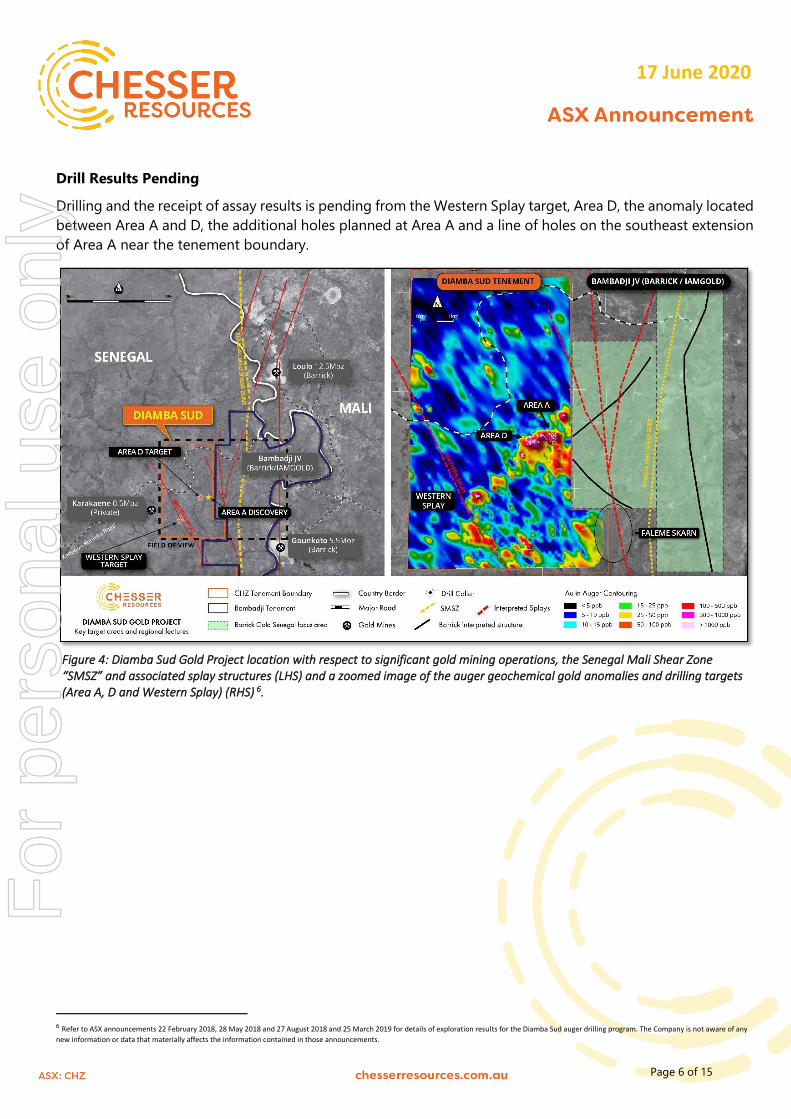
Drill Results Pending
Drilling and the receipt of assay results is pending from the Western Splay target, Area D, the anomaly located
between Area A and D, the additional holes planned at Area A and a line of holes on the southeast extension
of Area A near the tenement boundary.
Figure 4: Diamba Sud Gold Project location with respect to significant gold mining operations, the Senegal Mali Shear Zone “SMSZ” and associated splay structures (LHS) and a zoomed image of the auger geochemical gold anomalies and drilling targets (Area A, D and Western Splay) (RHS) 6.
6 Refer to ASX announcements 22 February 2018, 28 May 2018 and 27 August 2018 and 25 March 2019 for details of exploration results for the Diamba Sud auger drilling program. The Company is not aware of any
new information or data that materially affects the information contained in those announcements.
For
per
sona
l use
onl
y
Page 7 of 15
March 2019
17 June 2020
TABLE 1: SUMMARY OF SIGNIFICANT GOLD INTERSECTIONS FROM DIAMBA SUD
Hole ID From
(m)
To
(m)
Interval
(m)
Gold
(g/t Au)
DSR134 64 69 5 1.02
70 75 5 1.05
78 80 2 2.46
DSR135 0 8 8 2.90
14 26 12 3.86
incl 14 18 4 10.67
72 87 15 2.98
incl 80 84 4 7.35
94 118 24 3.29
incl 95 103 8 6.81
124 125 1 1.34
DSR138 117 132 15 3.39
incl 117 122 5 5.78
DSR140 64 66 2 1.59
DSR143 34 40 6 1.15
DSR144 30 32 2 1.09
96 119 23 3.50
incl 96 102 6 5.44
110 116 6 5.60
127 135 8 1.58
147 155 8 1.37
Intervals are reported using a threshold of 1g/t Au or greater average over the interval equal or greater to 1m and selects all material greater
than 0.35g/t Au with a maximum internal dilution of 2m. Intervals are interpreted as being 70-90% of true width based on current
interpretation of the orientation of the mineralised zones. Holes not included in this Table were not considered to have intersected significant
gold mineralisation.
This release was authorised by the Board of Directors of Chesser Resources Limited.
Figure 5: Schematic regional geology of eastern Senegal, showing the Diamba Sud Project and its proximity to both the SMSZ, and the major gold operations and projects on or adjacent to splays off the SMSZ.
For
per
sona
l use
onl
y
Page 9 of 15
March 2019
17 June 2020
ABOUT CHESSER RESOURCES
Chesser Resources is an ASX listed gold exploration company with projects located in Senegal, West Africa.
Chesser has announced a high-grade gold discovery at its Northern Arc target on its flagship Diamba Sud
project. The Company currently holds ~300km2 of highly prospective ground in this underexplored world-
class gold region. The Company has a corporate office located in Brisbane, Australia and a corporate and
technical team based in Dakar, Senegal.
Diamba Sud is the Company’s flagship project, covering 53.2km2 over the gold-bearing Kedougou-Kenieba
Inlier, Diamba Sud consists of two blocks referred to as DS1 in the north and DS2 in the south.
The Project is located ~2km to the west of the Senegal Mali Shear Zone (SMSZ), a major regional structure
and host to numerous multimillion-ounce gold deposits including; B2Gold’s 7.6Moz Fekola mine, Barrick’s
18Moz Loulo-Gounkoto complex and AngloGold Ashanti/IAMGold’s Sadiola and Yatela mines. DS1 lies 7km
to the west of the 5.5Moz Gounkoto mine and to the immediate east of the privately owned 0.5Moz Karakaene
mine.
Competent Person’s Declaration
The information in this report that relates to the Diamba Sud and Diamba Nord exploration results, Mineral Resources and Exploration Targets is based on information compiled by Mr Gareth O’Donovan, Ba Hons, MSc, FGS FIOM3, CEng, who is employed as Exploration Manager for Chesser Resources Ltd. Mr O’Donovan has sufficient experience which is relevant to the style of mineralisation and type of deposits under consideration and to the activity which he is undertaking to qualify as a Competent Person as defined in the 2012 Edition of the ‘Australasian Code for Reporting of Exploration Results, Mineral Resources and Ore Reserves.’ Mr O’Donovan consents to the inclusion in the announcement of the matters based on his information in the form and context that the information appears.
For
per
sona
l use
onl
y
Page 10 of 15
March 2019
17 June 2020
Forward looking statements
Statements relating to the estimated or expected future production, operating results, cash flows and costs and financial condition of
Chesser Resources Limited’s planned work at the Company’s projects and the expected results of such work are forward-looking
statements. Forward-looking statements are statements that are not historical facts and are generally, but not always, identified by
words such as the following: expects, plans, anticipates, forecasts, believes, intends, estimates, projects, assumes, potential and
similar expressions. Forward-looking statements also include reference to events or conditions that will, would, may, could or should
occur. Information concerning exploration results and mineral reserve and resource estimates may also be deemed to be forward-
looking statements, as it constitutes a prediction of what might be found to be present when and if a project is developed.
These forward-looking statements are necessarily based upon a number of estimates and assumptions that, while considered
reasonable at the time they are made, are inherently subject to a variety of risks and uncertainties which could cause actual events
or results to differ materially from those reflected in the forward-looking statements, including, without limitation: uncertainties related
to raising sufficient financing to fund the planned work in a timely manner and on acceptable terms; changes in planned work resulting
from logistical, technical or other factors; the possibility that results of work will not fulfil projections/expectations and realize the
perceived potential of the Company’s projects; uncertainties involved in the interpretation of drilling results and other tests and the
estimation of gold reserves and resources; risk of accidents, equipment breakdowns and labour disputes or other unanticipated
difficulties or interruptions; the possibility of environmental issues at the Company’s projects; the possibility of cost overruns or
unanticipated expenses in work programs; the need to obtain permits and comply with environmental laws and regulations and other
government requirements; fluctuations in the price of gold and other risks and uncertainties.
ATTACHMENT 1
TABLE 1: LOCATION OF RC DRILLING REPORTED
Hole ID Easting Northing RL (m) Azimuth Dip Depth (m)
DSR130 233281 1429602 154 225 -60 78
DSR132 233567 1429424 151 220 -60 78
DSR133 233588 1429452 151 220 -60 78
DSR134 233536 1429397 151 220 -60 84
DSR135 233346 1429550 151 225 -60 126
DSR136 233280 1429599 154 225 -60 126
DSR138 233250 1429510 157 270 -60 132
DSR140 233510 1429373 150 220 -60 75
DSR141 233575 1429363 150 220 -60 78
DSR142 233548 1429328 150 220 -60 78
DSR143 233597 1429393 150 220 -60 78
DSR144 233260 1429360 149 270 -60 174
Azimuths taken from the top of the down hole survey
For
per
sona
l use
onl
y
Page 11 of 15
March 2019
17 June 2020
ATTACHMENT 2
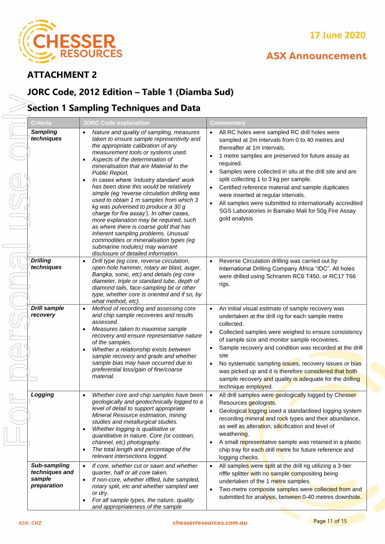
JORC Code, 2012 Edition – Table 1 (Diamba Sud)
Section 1 Sampling Techniques and Data
Criteria JORC Code explanation Commentary
Sampling techniques
• Nature and quality of sampling, measures taken to ensure sample representivity and the appropriate calibration of any measurement tools or systems used.
• Aspects of the determination of mineralisation that are Material to the Public Report.
• In cases where ‘industry standard’ work has been done this would be relatively simple (eg ‘reverse circulation drilling was used to obtain 1 m samples from which 3 kg was pulverised to produce a 30 g charge for fire assay’). In other cases, more explanation may be required, such as where there is coarse gold that has inherent sampling problems. Unusual commodities or mineralisation types (eg submarine nodules) may warrant disclosure of detailed information.
• All RC holes were sampled RC drill holes were
sampled at 2m intervals from 0 to 40 metres and
thereafter at 1m intervals.
• 1 metre samples are preserved for future assay as
required.
• Samples were collected in situ at the drill site and are
split collecting 1 to 3 kg per sample.
• Certified reference material and sample duplicates
were inserted at regular intervals.
• All samples were submitted to internationally accredited
SGS Laboratories in Bamako Mali for 50g Fire Assay
gold analysis
Drilling techniques
• Drill type (eg core, reverse circulation, open-hole hammer, rotary air blast, auger, Bangka, sonic, etc) and details (eg core diameter, triple or standard tube, depth of diamond tails, face-sampling bit or other type, whether core is oriented and if so, by what method, etc).
• Reverse Circulation drilling was carried out by
International Drilling Company Africa “IDC”. All holes
were drilled using Schramm RC6 T450, or RC17 T66
rigs.
Drill sample recovery
• Method of recording and assessing core and chip sample recoveries and results assessed.
• Measures taken to maximise sample recovery and ensure representative nature of the samples.
• Whether a relationship exists between sample recovery and grade and whether sample bias may have occurred due to preferential loss/gain of fine/coarse material.
• An initial visual estimate of sample recovery was
undertaken at the drill rig for each sample metre
collected.
• Collected samples were weighed to ensure consistency
of sample size and monitor sample recoveries.
• Sample recovery and condition was recorded at the drill
site
• No systematic sampling issues, recovery issues or bias
was picked up and it is therefore considered that both
sample recovery and quality is adequate for the drilling
technique employed.
Logging • Whether core and chip samples have been geologically and geotechnically logged to a level of detail to support appropriate Mineral Resource estimation, mining studies and metallurgical studies.
• Whether logging is qualitative or quantitative in nature. Core (or costean, channel, etc) photography.
• The total length and percentage of the relevant intersections logged.
• All drill samples were geologically logged by Chesser
Resources geologists.
• Geological logging used a standardised logging system
recording mineral and rock types and their abundance,
as well as alteration, silicification and level of
weathering.
• A small representative sample was retained in a plastic
chip tray for each drill metre for future reference and
logging checks.
Sub-sampling techniques and sample preparation
• If core, whether cut or sawn and whether quarter, half or all core taken.
• If non-core, whether riffled, tube sampled, rotary split, etc and whether sampled wet or dry.
• For all sample types, the nature, quality and appropriateness of the sample
• All samples were split at the drill rig utilizing a 3-tier
riffle splitter with no sample compositing being
undertaken of the 1 metre samples.
• Two-metre composite samples were collected from and
submitted for analysis, between 0-40 metres downhole.
For
per
sona
l use
onl
y
Page 12 of 15
March 2019
17 June 2020
Criteria JORC Code explanation Commentary
preparation technique.
• Quality control procedures adopted for all sub-sampling stages to maximise representivity of samples.
• Measures taken to ensure that the sampling is representative of the in-situ material collected, including for instance results for field duplicate/second-half sampling.
• Whether sample sizes are appropriate to the grain size of the material being sampled.
From 40 metres to EOH 1metres samples were
submitted for analysis.
• Duplicates were taken to evaluate representativeness
• Further sample preparation was undertaken at the SGS
laboratories by SGS laboratory staff
• At the laboratory, samples were weighed, dried and
crushed to 75% <2mm (jaw crusher), pulverized and
split to 85 %< 75 um. Gold is assayed by fire assay
(50g charge) with an AAS Finish.
• The crushed sample was split and 1.5kg sample was
collected using a single stage riffle splitter
• The 1.5kg split samples were pulverised in a an LM2 to
95% passing 200 meshes
• Barren sand wash was required at the start of each
batch and between samples
• Sample pulps are retained at the SGS laboratory under
secure ''chain of custody'' procedure for possible future
analysis.
• Sample sizes and laboratory preparation techniques
are considered to be appropriate for this early stage
exploration and the commodity being targeted.
Quality of assay data and laboratory tests
• The nature, quality and appropriateness of the assaying and laboratory procedures used and whether the technique is considered partial or total.
• For geophysical tools, spectrometers, handheld XRF instruments, etc, the parameters used in determining the analysis including instrument make and model, reading times, calibrations factors applied and their derivation, etc.
• Nature of quality control procedures adopted (eg standards, blanks, duplicates, external laboratory checks) and whether acceptable levels of accuracy (ie lack of bias) and precision have been established.
• Analysis for gold is undertaken at SGS Mali by 50g Fire
Assay with an AAS finish to a lower detection limit of
0.01ppm Au.
• The fire assay method used has an upper limit of
100g/t.
• Fire assay is considered a “total” assay technique.
• No field non assay analysis instruments were used in
the analyses reported.
• A review of certified reference material and sample
blanks inserted by the Company indicated no significant
analytical bias or preparation errors in the reported
analyses.
• Results of analyses for field sample duplicates are
consistent with the style of mineralisation evaluated and
considered to be representative of the geological zones
which were sampled.
• Internal laboratory QAQC checks are reported by the
laboratory and a review of the QAQC reports suggests
the laboratory is performing within acceptable limits
Verification of sampling and assaying
• The verification of significant intersections by either independent or alternative company personnel.
• The use of twinned holes.
• Documentation of primary data, data entry procedures, data verification, data storage (physical and electronic) protocols.
• Discuss any adjustment to assay data.
• All drill hole data is paper logged at the drill site and
then digitally entered by Company geologists at the site
office.
• All digital data is verified and validated before loading
into the drill hole database.
• No twinning of holes was undertaken in this program
which is early stage exploration in nature.
• Reported drill results were compiled by the company’s
geologists, verified by the Company’s exploration
manager.
• No adjustments to assay data were made.
Location of data points
• Accuracy and quality of surveys used to locate drill holes (collar and down-hole surveys), trenches, mine workings and other locations used in Mineral Resource
• Drill hole collars were located using GPS averaging.
• Accuracy of the averaging of the GPS < +/- 2m and is
considered appropriate for this level of early exploration
For
per
sona
l use
onl
y
Page 13 of 15
March 2019
17 June 2020
Criteria JORC Code explanation Commentary
estimation.
• Specification of the grid system used.
• Quality and adequacy of topographic control.
• The grid system is UTM Zone 29N
Data spacing and distribution
• Data spacing for reporting of Exploration Results.
• Whether the data spacing, and distribution is sufficient to establish the degree of geological and grade continuity appropriate for the Mineral Resource and Ore Reserve estimation procedure(s) and classifications applied.
• Whether sample compositing has been applied.
• RC holes were located on an irregularly spaced pattern
with between 20 and 50m between various collars
along the line.
• Drilling reported in this program is of an early
exploration nature has not been used to estimate any
mineral resources or reserves.
Orientation of data in relation to geological structure
• Whether the orientation of sampling achieves unbiased sampling of possible structures and the extent to which this is known, considering the deposit type.
• If the relationship between the drilling orientation and the orientation of key mineralised structures is considered to have introduced a sampling bias, this should be assessed and reported if material.
• Exploration is at an early stage and, as such,
knowledge on exact location of mineralisation and its
relation to lithological and structural boundaries is not
accurately known. However, the current drill hole
orientation is considered appropriate for the program to
reasonably assess the prospectivity of known
structures interpreted from other data sources.
Sample security • The measures taken to ensure sample security.
• RC samples were collected and taken to the SGS
laboratory in Mali under secure ''chain of custody''
procedure by SGS Mali staff.
• Sample pulps remain at the SGS laboratory under
secure ''chain of custody''
• The RC samples remaining were removed from the site
and stored at the company’s field camp in Saraya.
Audits or reviews
• The results of any audits or reviews of sampling techniques and data.
• There has been no external audit or review of the
Company’s sampling techniques or data at this early
exploration stage.
For
per
sona
l use
onl
y
Page 14 of 15
March 2019
17 June 2020
Section 2 Reporting of Exploration Results
Criteria JORC Code explanation Commentary
Mineral tenement and land tenure status
• Type, reference name/number, location and ownership including agreements or material issues with third parties such as joint ventures, partnerships, overriding royalties, native title interests, historical sites, wilderness or national park and environmental settings.
• The security of the tenure held at the time of reporting along with any known impediments to obtaining a licence to operate in the area.
• The results reported in this report are all
contained within The Diamba Sud permit which
is held 100% by Boya S.A., a wholly owned
subsidiary of Chesser Resources.
• The Diamba Sud permit is in good standing,
with an expiry date of 08/6/2021.
Exploration done by other parties
• Acknowledgment and appraisal of exploration by other parties.
• The area that is presently covered by the
Diamba Sud was explored intermittently by
several companies prior to 2015.
• Exploration consisted of a government backed
regional aeromagnetic survey, gridding, soil
sampling and minor auger and exploration
drilling.
• IAM Gold undertook minor RAB and Auger
drilling at the project (Bembala Prospect)
during 2012. The results of which are not
known by Chesser Resources Ltd
Geology • Deposit type, geological setting and style of mineralisation.
• The deposit style targeted for exploration is
orogenic lode gold.
• This style of mineralisation can occur as veins
or disseminations in altered (often silicified)
host rock or as pervasive alteration over a
broad zone.
• Deposits are often found in close proximity to
linear geological structures (faults & shears)
often associated with deep-seated structures.
• Lateritic weathering is common within the
project area. The depth to fresh rock is variable
and may extend up to 50m below surface.
Drill hole Information
• A summary of all information material to the understanding of the exploration results including a tabulation of the following information for all Material drill holes: o easting and northing of the drill hole collar o elevation or RL (Reduced Level – elevation
above sea level in metres) of the drill hole collar
o dip and azimuth of the hole o down hole length and interception depth o drill hole length.
• If the exclusion of this information is justified on the basis that the information is not Material and this exclusion does not detract from the understanding of the report, the Competent Person should clearly explain why this is the case.
• Reported results are summarised in Table 1
and within the main body of the announcement
• Drill collar elevation is defined as height above
sea level in metres (RL)
• RC holes were drilled at an angle deemed
appropriate to the local structure as understood
at the time of drilling.
• Down hole length of the hole is the distance
from the surface to the end of the hole, as
measured along the drill trace
Data aggregation methods
• In reporting Exploration Results, weighting averaging techniques, maximum and/or minimum grade truncations (eg cutting of high grades) and cut-off grades are usually Material and should be stated.
• Where aggregate intercepts incorporate short lengths of high-grade results and longer lengths of low grade results, the procedure used for such
• Intervals are reported using a threshold where
the interval has a 1.00 g/t Au average or
greater over the sample interval and selects all
material greater than 0.35 g/t Au, with
maximum of 2m of internal dilution.
• No grade top cut off has been applied to full
results presented in Attachment 1.
For
per
sona
l use
onl
y
Page 15 of 15
March 2019
17 June 2020
Criteria JORC Code explanation Commentary
aggregation should be stated and some typical examples of such aggregations should be shown in detail.
• The assumptions used for any reporting of metal equivalent values should be clearly stated.
• No metal equivalent reporting is used or
applied
Relationship between mineralisation widths and intercept lengths
• These relationships are particularly important in the reporting of Exploration Results.
• If the geometry of the mineralisation with respect to the drill hole angle is known, its nature should be reported.
• If it is not known and only the down hole lengths are reported, there should be a clear statement to this effect (eg ‘down hole length, true width not known’).
• The results reported in this announcement are
considered to be of an early stage in the
exploration of the project.
• Mineralisation geometry is not accurately
known as the exact orientation and extent of
known mineralised structures are not yet
determined.
• Mineralisation results are reported as
“downhole” widths as true widths are not yet
known
Diagrams • Appropriate maps and sections (with scales) and tabulations of intercepts should be included for any significant discovery being reported These should include, but not be limited to a plan view of drill hole collar locations and appropriate sectional views.
• Drill hole location plans are provided in Figure
2.
Balanced reporting
• Where comprehensive reporting of all Exploration Results is not practicable, representative reporting of both low and high grades and/or widths should be practiced to avoid misleading reporting of Exploration Results.
• The drilling programme is ongoing, but all drill
holes completed with assay results as of the
reported date have been included herein -refer
Table 1.
• No completed surveyed holes are omitted for
which complete results have been received.
Other substantive exploration data
• Other exploration data, if meaningful and material, should be reported including (but not limited to): geological observations; geophysical survey results; geochemical survey results; bulk samples – size and method of treatment; metallurgical test results; bulk density, groundwater, geotechnical and rock characteristics; potential deleterious or contaminating substances.
• No other exploration data that is considered
meaningful and material has been omitted from
this report
Further work • The nature and scale of planned further work (eg tests for lateral extensions or depth extensions or large-scale step-out drilling).
• Diagrams clearly highlighting the areas of possible extensions, including the main geological interpretations and future drilling areas, provided this information is not commercially sensitive.