Drinking Water Source Assessment for the City of Newton Falls SUMMARY Source Water Assessment and Protection. The following report for the City of Newton Falls was compiled as part of the Source Water Assessment and Protection Program for Ohio. This program is intended to identify drinking water protection areas and provide information on how to reduce the risk of contamination of the waters within those areas. The goal of the program is to ensure the long term availability of abundant and safe drinking water for the present and future citizens of Ohio. The Safe Drinking Water Act Amendments of 1996 established the national Source Water Assessment and Protection Program, targeting drinking water sources for all public water systems in the United States. A public water system is a facility that provides drinking water to 15 or more service connections or that regularly serves at least 25 people a day for at least 60 days a year, whether from an underground well or spring, or from an above ground stream, lake, or reservoir. The requirement does not address residential wells or cisterns. In Ohio there are approximately 5,800 public water systems. Background. The City of Newton Falls operates a community public water system that serves a population of approximately 6,260 people through 2,500 metered service connections. The source is surface water taken from the mainstem of the Mahoning River. The system’s treatment capacity is approximately 1.5 million gallons per day, but current average production is about 0.6 million gallons per day. Protection Areas. The drinking water source protection area for the surface water source is shown in the following figure. This report includes the results of an inventory of all known or identified potential contaminant sources within the drinking water source protection area. The inventory was conducted by Ohio EPA with the assistance of the City of Newton Falls Public Water System staff. Possible threats to the surface water source include agricultural runoff from row crop agriculture, oil and gas wells, failing home and commercial septic systems, spills and releases from recreational boating on public reservoirs, new housing and commercial development, numerous road crossings over the Mahoning River and its tributaries, and discharges from wastewater treatment facilities upstream of the intake. Protective Strategies. The ultimate goal of source water assessment is implementation of protective strategies that will better protect the drinking water source. Strategies for protecting the Mahoning River include controlling home and commercial septic discharges and runoff from agricultural and animal feedlot areas, controlling runoff from housing/commercial development construction sites, increasing public awareness of drinking water protection in recreational areas, and coordinating with local emergency response agencies. The City is also encouraged to continue investigation of utilizing the West Branch of the Mahoning River as an additional or alternate source of drinking water. The City of Newton Falls and other jurisdictions within the protection areas are encouraged to develop a local protection plan to protect the source of drinking water or to update current emergency management plans as applicable. Local
Transcript
Drinking Water Source Assessmentfor the City of Newton FallsSUMMARY
Source Water Assessment andProtection. The following report for theCity of Newton Falls was compiled as partof the Source Water Assessment andProtection Program for Ohio. This programis intended to identify drinking waterprotection areas and provide information onhow to reduce the risk of contamination ofthe waters within those areas. The goal ofthe program is to ensure the long termavailability of abundant and safe drinkingwater for the present and future citizens ofOhio.
The Safe Drinking Water Act Amendmentsof 1996 established the national SourceWater Assessment and Protection Program,targeting drinking water sources for allpublic water systems in the United States. A public water system is a facility thatprovides drinking water to 15 or moreservice connections or that regularly servesat least 25 people a day for at least 60 daysa year, whether from an underground wellor spring, or from an above ground stream,lake, or reservoir. The requirement doesnot address residential wells or cisterns. InOhio there are approximately 5,800 publicwater systems.
Background. The City of Newton Fallsoperates a community public water systemthat serves a population of approximately6,260 people through 2,500 metered serviceconnections. The source is surface watertaken from the mainstem of the MahoningRiver. The system’s treatment capacity isapproximately 1.5 million gallons per day,but current average production is about 0.6million gallons per day.
Protection Areas. The drinking watersource protection area for the surface watersource is shown in the following figure. This
reportincludes the results of an inventory of allknown or identified potential contaminantsources within the drinking water sourceprotection area. The inventory wasconducted by Ohio EPA with the assistanceof the City of Newton Falls Public WaterSystem staff. Possible threats to thesurface water source include agriculturalrunoff from row crop agriculture, oil and gaswells, failing home and commercial septicsystems, spills and releases fromrecreational boating on public reservoirs,new housing and commercial development,numerous road crossings over theMahoning River and its tributaries, anddischarges from wastewater treatmentfacilities upstream of the intake.
Protective Strategies. The ultimate goal ofsource water assessment is implementationof protective strategies that will betterprotect the drinking water source. Strategies for protecting the Mahoning Riverinclude controlling home and commercialseptic discharges and runoff fromagricultural and animal feedlot areas,controlling runoff from housing/commercialdevelopment construction sites, increasingpublic awareness of drinking waterprotection in recreational areas, andcoordinating with local emergency responseagencies. The City is also encouraged tocontinue investigation of utilizing the WestBranch of the Mahoning River as anadditional or alternate source of drinkingwater.
The City of Newton Falls and otherjurisdictions within the protection areas areencouraged to develop a local protectionplan to protect the source of drinking wateror to update current emergencymanagement plans as applicable. Local
watershed planning efforts may also beunderway to guide stream restoration andprotection activities. These efforts can alsoserve to benefit the protection of drinkingwater sources. Guidance on how to form aDrinking Water Protection Team andprotection plan is available from the OhioEPA by calling (614) 644-2752.
For More Information. Additionalinformation on protective strategies and howthis assessment was completed is includedin the detailed Drinking Water SourceAssessment Report for the City of NewtonFalls. For information on how to obtain acopy of this report, please visit Ohio EPA’sSource Water Assessment and Protection
Program Web page athttp://www.epa.state.oh.us/ddagw/pdu/swap.html or contact the City of NewtonFalls for a copy.
Current information on the quality of thetreated water supplied by theNewton Falls Public Water System isavailable in the Consumer ConfidenceReport (CCR) for the Newton Falls PublicWater System. The CCR is distributedannually and it reports on detectedcontaminants and any associated healthrisks from data collected during the past fiveyears. Consumer Confidence Reports areavailable from the City of Newton Falls.
Summary Figure - City of Newton Falls Drinking Water Source Protection Area
Drinking Water Source Assessment
for the City of Newton Falls
Public Water System # 7802311
Trumbull County
Prepared by:Ohio Environmental Protection Agency
Division of Surface WaterDivision of Drinking and Ground Waters
Northeast District Office
February, 2003
1
How to Use this Assessment
Clean and safe drinking water is essential to everyone. Protecting the source of drinking wateris a wise and cost effective investment. The purpose of this drinking water source assessmentis to provide information your community can use to develop a local Drinking Water ProtectionProgram. The Drinking Water Source Assessment benefits your community by providing thefollowing:
A basis for focusing limited resources within the community to protect the drinking watersource(s).
The assessment provides your community with information regarding activities within theDrinking Water Source Protection Area that directly affect your water supply sourcearea. It is within this area that a release of contaminants, from a spill or improper usage,may travel through the watershed and reach the surface water intake. By examiningwhere the source waters are most sensitive to contaminants, and where potentialcontaminants are located, the assessment identifies the potential risks that should beaddressed first.
A basis for informed decision-making regarding land use within the community.The assessment provides your community with a significant amount of informationregarding where your drinking water comes from (the source) and what the risks are tothe quality of that source. This information allows your community planning authoritiesto make informed decisions regarding proposed land uses within the protection area thatare compatible with both your drinking water resource and the vision of growthembraced by your community.
A start to a comprehensive plan for the watershed and source water area.This assessment can be the beginning of a comprehensive plan for the water resource,one that addresses all of the uses the water resource provides. An ecologically healthylake, stream and watershed will provide a stable, high quality resource for drinkingwater.
For information about developing a local Drinking Water Source Protection Program, pleasecontact the Ohio EPA Division of Drinking and Ground Waters at (614)644-2752 or visit theDivision’s web site at http://www.epa.state.oh.us/ddagw/pdu/swap.html.
2
1.0 INTRODUCTION
The 1996 Amendments to the Safe Drinking Water Act established a program for states toassess the drinking water source for all public water systems. The Source Water Assessmentand Protection (SWAP) Program is designed to help Ohio’s public water systems protect theirsources of drinking water from becoming contaminated.
The purpose of this assessment is to identify where and how the City of Newton Falls' sourcewaters are at risk of contamination. The report• identifies the drinking water source protection area,• examines the characteristics of the watershed and the water quality,• inventories the potential contaminant sources within that area, and discusses the
susceptibility of the system to contamination.
Finally, the report suggests actions that the public water supplier and local community may taketo reduce the risk of contaminating their source of drinking water and ensure the long termavailability of abundant and safe drinking water resources.
Results and recommendations presented in this report are based on the information available atthe time of publication. Ohio EPA recognizes that additional information may become availablein the future that could be used to more accurately determine the drinking water sourceprotection area. Also, changes in land use may occur after Ohio EPA completes the potentialcontaminant source inventory. This report should be used as a starting point to develop a planto protect drinking water resources.
This report was written by Kelvin Rogers, Ohio EPA, Division of Surface Water, NortheastDistrict Office. The City of Newton Falls Water Treatment Plant Superintendent, Jeff Hawkins,assisted in development of this report.
2.0 PUBLIC WATER SYSTEM DESCRIPTION
The City of Newton Falls operates a community public water system that serves a population ofapproximately 6,260 people through 2,500 metered service connections. A community publicwater system is a system that regularly supplies drinking water from its own sources to at least15 service connections used by year-round residents of the area or regularly serves 25 or morepeople throughout the entire year. The water treatment plant obtains its water from themainstem of the Mahoning River. The treatment capacity is approximately 1.5 million gallonsper day, but current average production is about 0.6 million gallons per day.
The Newton Falls public water system consists of a conventional filtration water treatmentsystem with one elevated standpipe storage tower in the distribution system. The system has astorage capacity of 730,000 gallons. The intake was built in 1958. The intake is visuallyinspected twice a day, with intake screens cleaned as needed.
3.0 DRINKING WATER SOURCE PROTECTION AREA
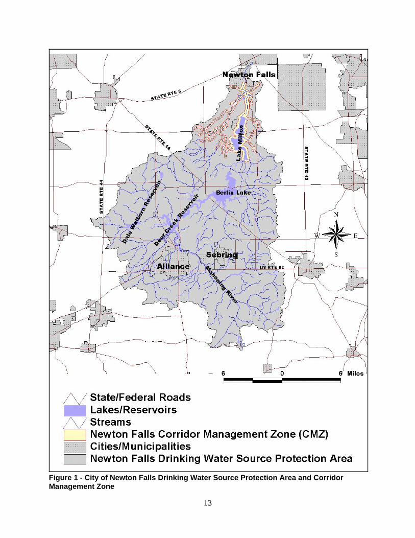
The Drinking Water Source Protection Area (protection area) for an inland stream is definedas the drainage area upstream of the point where the water is withdrawn from a surface watersource such as a stream, lake or reservoir. The protection area for the City of Newton Falls isfan-shaped and encompasses approximately 305 square miles. The protection area issubdivided into corridor and emergency management zones. An illustration of the northern
3
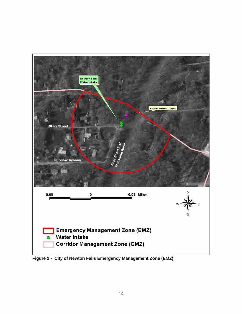
portion of the protection area and corridor management zone for the City of Newton Falls publicwater system is shown in Figure 1. The emergency management zone is shown in Figure 2.
The Corridor Management Zone, (CMZ), is the area within 1,000 feet of each bank of theMahoning River, starting from the intake and extending to the inlet to Lake Milton, a distance of approximately 10.9 miles. The corridor management zone also includes tributaries of theMahoning River. On tributaries the width of the corridor management zone is 500 feet fromeach bank. The length of the corridor management zone on a tributary is 10 stream miles fromthe intake. For example, a tributary four miles in length that enters the Mahoning River six milesupstream of the intake would be completely within the corridor management zone. A tributarystream entering eight miles from the intake would have only two miles of its stream length withinthe corridor management zone.
The Emergency Management Zone, (EMZ), is defined as an area in the immediate vicinity ofthe surface water intake in which the public water system operator has little or no time torespond to a spill. The boundary of the emergency management zone is delineated incooperation with the water supplier. Figure 2 shows the boundary of the emergencymanagement zone for the Newton Falls Public Water System.
The corridor and emergency management zones are the focus of field and windshield surveysto inventory potential contaminant sources.
4.0 RESOURCE CHARACTERIZATION
The main stem of the Mahoning River serves as the surface water source for the Newton FallsPublic Water System. The Mahoning River is approximately 108 miles in length with a drainagearea of 1,133 square miles, and combines with the Shenango River to form the Beaver Rivernear New Castle, Pennsylvania. The water system intake is located slightly more than 58 milesfrom the mouth. The average fall of the Mahoning River from the headwaters to the intake is7.4 feet per mile. Annual average precipitation in the protection area is approximately 36inches, of which 14 inches becomes surface runoff.
According to the 1996 Ohio EPA Biological and Water Quality Study of the Mahoning RiverBasin, the topography of the Mahoning River drainage area encompasses most of MahoningCounty and portions of Columbiana, Stark, Portage, Geauga, and Trumbull Counties in Ohio,plus the western portion of Lawrence County in Pennsylvania. Natural stream flows of theMahoning River have been altered by an extensive reservoir system constructed for low flowaugmentation, temperature and flood control, and water supply. Nine low head dams along thelower main stem have altered natural stream morphology to create sufficient pool depth forindustrial water intakes. In the lower main stem, stream flow regulation results in highersummer minimum flows than winter minimum flows, opposite that of most natural streams inOhio.
Lake Milton was constructed by the City of Youngstown in 1917 to provide low flowaugmentation for steel production during World War I. The Army Corps of Engineers operates
this reservoir in conjunction with the Berlin and Kirwan Reservoirs to maintain the flowregulation schedule at Leavittsburg.
The Mahoning River watershed lies within the gently rolling dissected glacial plateau of theErie/Ontario Lake Plain ecoregion. Most of the streams in this area are perennial and shallow
4
cutting. Varying thicknesses of glacial drift were deposited over Pennsylvanian shales andMississippian sandstones during the Pleistocene era. The preglacial valleys within theunderlying bedrock shales and sandstone were also buried by glacial clays, sands, and gravels. The watershed exhibits a mosaic of cropland, pasture, woodland and urban development.
Figure 3 shows the land use for the entire protection area. The predominant land use isagricultural, with pasture/hay farms in 33% of the area. Deciduous forests (30%) and row crops(22%) account for the majority of the remaining protection area.
Soils in the northern part of the protection area around the Corridor Management Zone includethose in the Chili-Jimtown-Oshteno, Fitchville-Haskins-Sebring, Remsen-Geeburg-Trumbull andMahoning Ellsworth associations. These consist of nearly level to very steep soils, somewhatpoorly drained to moderately well drained, formed in glacial till and outwash or lacustrinematerials.
Stream flow and time of travelThe quality of the water in a stream can change under different precipitation and flowconditions. Both high flow or low flow conditions can result in water quality problems andimpacts to the source water. Typically heavy rains and high flows result in more materialsdissolved and suspended in the runoff or re-suspended from the stream bottom and banks. Thehigher flows result in faster travel times for any contaminant plume, however the greater volumeof water results in a lower concentration (given the same amount of material) relative to low flowconditions. Conversely, low flow conditions in a stream result in slow travel times and moreconcentrated contaminant plumes, and can exacerbate problems such as low dissolved oxygenand algal blooms. In addition, the inflow of ground water to the stream will bring with it anydissolved contaminants.
It is recommended that the water treatment plant operator develop estimates of the expectedand fastest probable travel times of the leading edge of a contaminant plume through thecorridor management zone to the public water system intake. These estimates may be basedon procedures for estimating travel times that were developed by the U.S. Geological Survey. The water treatment plant operator can use the estimates to help determine how long after aspill to continue drawing water from the Mahoning River. Use of such estimates requiresknowing or estimating the flow level in the Mahoning River near the drinking water intake. Thebest estimate of flow for the Mahoning River intake is the USGS flow gage which is located onthe Mahoning River at Pricetown. Current flow levels for this and other USGS gages can beaccessed via the Internet at the following address: http://waterdata.usgs.gov/nwis-w/OH/. Thestation number for the USGS gage on the Mahoning River is 03091500. Other USGS flowgages that may aid in determining flow levels include those located at Milton Reservoir nearPricetown (station number 03091000) and on Kale Creek near Pricetown (station number03092000).
Drinking Water Quality Monitoring SummaryAvailable chemical and biological water quality data collected from the streams in the protectionarea, and sampling results from finished water reported to Ohio EPA by the public watersupplier were evaluated to characterize water quality. A review of the City of Newton Fallscompliance monitoring data from 1991-2002 revealed that the system had no health based ormaximum contaminant level (MCLs) violations. Table 1 lists contaminants where at least oneresult was above the level of detection and does not include all contaminants tested for by thepublic water system. The table also includes data from the City of Newton Fall’s participation in
5
Ohio EPA’s Pesticide Special Study (1995-1999).
Newton Falls monitors raw water daily for pH, alkalinity, hardness, turbidity, and fluoride. Samples for common Synthetic Organic Compounds (SOCs) are collected as often asbimonthly from May to August. Volatile Organic Compounds (VOCs) are monitored every sixmonths and Total Organic Carbon (TOC) is monitored every quarter. In addition, raw riverwater samples are collected weekly on the mainstem (2 sites), West Branch, Kale Creek andPricetown Bridge. These are monitored for pH, alkalinity, hardness, turbidity, and fluoride.
Water treatment plant personnel report significant raw water turbidity increases following stormevents, especially noticeable in Kale Creek upstream of the intake. These appear to be due toagricultural activities and soil erosion in the upstream areas. Atrazine (a common herbicideSOC) levels are typically higher in raw water samples during the corn growing season (May -June), particularly after storm events. In addition, attached algae are visually observed aroundthe intake structure during the summer months. Low stream flows combined with elevatedlevels of organic compounds and algae are believed to contribute to taste and odor problemsduring the summer months. The plant utilizes carbon filtration to reduce or eliminate these inthe finished drinking water, as well as to meet current trihalomethane (THM) standards.
The treatment plant will be upgrading its facilities in order to meet 2004 drinking waterregulations and beyond. The plant processes will be modified to increase its capacity slightly,and to provide more consistency in meeting THM and haloacetic acid (HAA) requirements infinished water. The new facility is expected to be constructed in 2003 and online in 2004.
It should be recognized that sampling results presented in this report can only provideinformation on the quality of the water at the time the sample was collected. Water quality maychange over time due to a number of reasons. Therefore, it is recommended that the readeralso consult the most recent Consumer Confidence Report (CCR) for the City of Newton Fallspublic water system. All public water systems are required to annually prepare and distributethe CCR to their customers. The report is a good source of information of health effectsassociated with detected contaminants and contains information on the community's drinkingwater, including the source of the water, contaminants detected, the likely sources of detectedcontaminants, and the potential health effects of contaminants at levels above the drinkingwater standards.
Biological and Chemical Monitoring in the Mahoning River and its TributariesIn 1994, Ohio EPA conducted a biological and water quality study of the Mahoning Riverwatershed. No exceedences of chemical water quality standards were noted within the corridormanagement zone. Fish and aquatic macroinvertebrate communities within the CMZ werefound to be in PARTIAL attainment (downstream of Lake Milton at river mile 62.7 - 63.6) or NONattainment (downstream of Kale Creek, upstream of Newton Falls at river mile 57.8 - 59.1) withwarmwater habitat biocriteria. This failure to meet the standards was attributed to theimpounded nature of the Mahoning River in this area below Lake Milton and resulting loss of afree-flowing riverine habitat.
5.0 POTENTIAL CONTAMINANT SOURCES
A review of available regulated facility databases and a field survey of the corridor managementzone indicate that 28 contaminant sources and 71 oil and gas wells are present in the corridormanagement zone. Only one potential contaminant source, a storm sewer outlet, is locatedwithin the emergency management zone just downstream of the intake structure (See Figure 2).
6
Table 2 provides a list of the identified potential contaminant sources in the vicinity of thecorridor management zone. The location of potential contaminant sources in the corridormanagement zone is shown in Figure 4. A map showing the locations of oil and wells andpipelines within the northern portion of the protection area and corridor management zone ispresented in Figure 5.
It is important to note that this inventory represents potential contaminant sources, and includesany source that has the potential to release a contaminant to surface or ground waters in theprotection area. It is beyond the scope of this study to determine whether any specific potentialsource is actually releasing a contaminant, or to what extent any potential source(s) may becontributing to the overall pollutant load. The information derived from these databases shouldbe verified and updated before initiating control or abatement efforts for a specific contaminantsource.
The transportation network is a potential source of contamination through vehicular accidentsthat release hazardous materials. Approximately 48 miles of roads traverse the City of NewtonFalls corridor management zone (CMZ), creating a total of 59 road crossings of Lake Milton, theMahoning River or its tributaries within the CMZ. No rail lines are currently present within theCMZ. Approximately 3.6 miles of roads are within 100 feet of a stream in the CMZ. Approximately 5.5 miles of oil and gas pipeline traverse the City of Newton Falls CMZ, withapproximately 0.8 miles of pipeline within 100 feet of a stream.
6.0 SUSCEPTIBILITY ANALYSIS
For the purposes of source water assessments, all surface waters are considered to besusceptible to contamination. By their nature surface waters are accessible and can be readilycontaminated by chemicals and pathogens with relatively short travel times from source to theintake. Based on the information compiled for this assessment, the Newton Falls protectionarea is susceptible to agricultural runoff from row crop agriculture, oil and gas wells, failinghome and commercial septic systems, spills and releases from recreational boating on publicreservoirs, new housing and commercial development that could increase runoff from roads andparking lots, numerous road crossings over the Mahoning River and its tributaries, anddischarges from wastewater treatment facilities upstream of the intake.
It is important to note that this assessment is based on available data, and therefore may notreflect current conditions in all cases. Water quality, land uses and other activities that arepotential sources of contamination may change with time. While the source water for the City ofNewton Falls Public Water System is considered susceptible to contamination, historically, theNewton Falls Public Water System has effectively treated this source water to meet drinkingwater quality standards.
7.0 PROTECTIVE STRATEGIES
Source water protection efforts for City of Newton Falls should focus on controlling agriculturalrunoff and runoff from cattle grazing pastures, with particular attention to sources of pesticides,nitrates, phosphorus, and microorganisms such as fecal coliform bacteria. This can beaccomplished via educational efforts and implementation of best management practices. County Extension agents are an excellent resource for assisting the agricultural community withcontrolling agricultural runoff, and staff from local and County health offices can instructhomeowners in proper maintenance of their septic systems. In addition, the City of NewtonFalls is encouraged to continue its investigations into utilization of the West Branch of theMahoning River as an additional or alternate source of drinking water.
7
Other source water protection efforts may include:
Education and Outreach: Informing people who live, work, or own property within theprotection area about the benefits of drinking water protection is very important. Although somecommunities develop their own educational outreach resources, assistance is available at nocost from various agencies. For example, staff from Ohio EPA’s Office of Pollution Preventioncan visit businesses (free of charge) and provide recommendations on how they can modifytheir processes, materials and practices to generate less pollution in a cost-effective andtechnically feasible manner. An effort should be made to educate homeowners and businessesof the potential threat their activities can pose to the water supply. Education could also focuson increasing public awareness of illegal dumping and drinking water protection, particularly inrecreational boating areas.
Coordination with Existing Activities: Many local groups are engaged in programs thatcomplement a public water system’s drinking water source protection efforts. Working withgroups such as the Natural Resources Conservation Service, the Soil and Water ConservationService, the Farm Bureau, or a local watershed planning organization ensures coordination oftheir respective programs. The Mahoning River Consortium is an active group working withinthe Mahoning River Watershed and information is available on their website at http://mahoningriver.co.trumbull.oh.us/.
Oil and Gas Production: Education could be provided (material/meetings) to owners and landowners on proper operation and maintenance. A early warning system for accidental spills andreleases could be developed.
Transportation Routes: There is a potential for spills along roads within the protection area.The City of Newton Falls may want to consider contacting the local fire department and localemergency planning agency about the location of the drinking water source protection area, sothat strategies can be developed to prevent spilled materials from impacting the MahoningRiver.
Emergency Response Planning: The City of Newton Falls should prepare a plan that includesearly warning of spills and coordination of response and remediation activities for spills that mayenter the Mahoning River. This plan should include emergency response actions for the river,such as the placement of absorbent booms to control oil spills, or the ability to mechanically addoxygen to oxidize chemicals with a high oxygen demand. Different response plans could bedeveloped for different types of contamination. The emergency response plan may also containstrategies for dealing with unexpected levels of runoff containing chemicals such as fertilizersand pesticides from adjacent land uses. Though it may be less catastrophic than a major spill,this kind of contamination is more prevalent and is harder to detect and contain.
Zoning Ordinances: A water protection zoning ordinance is a regulatory control that typicallyplaces some restrictions or standards on activities conducted within a specified zone (such asthe corridor management zone and/or the emergency management zone). Such ordinancesenable the municipality to require people who live or work in this area to avoid contaminating thesource of the municipality’s drinking water. Ordinances can help ensure best managementpractices are being employed at local businesses and can help reduce the volume ofcontaminants stored within the protection area. The City of Newton Falls may want to considerworking with the counties, townships, and municipalities in the protection area to develop zoningoverlays that require specific standards for chemical storage, handling of waste materials, andother source control strategies. Several communities in Ohio have enacted very successful
8
drinking water source protection ordinances. Copies can be obtained by contacting Craig Smithat (614) 644-2752.
Regulatory Compliance: Where possible, the City of Newton Falls can monitor thecompliance of potential contaminant sources with existing regulations through inspectionsand/or contact with regulatory agencies. If routine inspections are a regulatory requirement,they provide an excellent opportunity to educate an important segment of the community aboutthe importance of drinking water source protection. Inspections also provide an opportunity toencourage improved materials handling procedures, hazardous materials training, waste anddisposal assessments, facility spill/contingency planning, and pollution prevention initiatives.
The City of Newton Falls and stakeholders within the protection area are encouraged to developa local program to protect the source waters. A local program is capable of responding tochanging conditions within the watershed and can bring together the local governments andstakeholders needed for an effective protection effort. Source water protection efforts couldbenefit the community by allowing the Newton Falls water treatment plant to more fully use itssurface water resource. Protecting the source water can also benefit those in the protectionarea who are not using the Mahoning River for drinking water. A high quality source waterenhances other uses such as fishing, recreation, and water supply for agriculture or industry.
Ohio EPA encourages the City of Newton Falls to incorporate the types of protective strategieslisted above into a drinking water source protection plan. Two guidance documents areavailable from Ohio EPA to assist with development of a Drinking Water Source Protection andManagement Plan. A Guide to Developing Local Watershed Action Plans in Ohio” is availableon the internet at www.epa.state.oh.us/dsw/hps/wsguide.pdf and “Developing Local DrinkingWater Source Protection Plans in Ohio” at www.epa.state.oh.us/ddagw/pdu/ swap_psdoc.pdf.For more information on drinking water source protection please contact the Drinking WaterProtection staff at (614) 644-2752.
9
References
Biological and Water Quality Study of the Mahoning River Basin, Volume 1. OEPA TechnicalReport MAS/1995-12-14, State of Ohio Environmental Protection Agency, 1996.
Soil Survey, Mahoning County, Ohio. USDA Soil Conservation Service, 1971.
Soil Survey of Portage County, Ohio. USDA Soil Conservation Service, 1978.
Soil Survey of Trumbull County, Ohio. USDA Soil Conservation Service, 1992.
10
Table 1 - Water Quality Monitoring Summary of Treated Water City of Newton Falls Public Water System
Ohio EPA Public Water System Compliance Monitoring Database (1991- 2002)Ohio EPA Pesticide Special Study (May 1995 - March 1999)
Contaminant(units)
LevelsFound
PrimaryMCL
ExceedsMCL 1 Typical Source
Inorganic Contaminants
Arsenic (µg/l) 4.0 50 NoErosion of natural deposits; Runoff fromorchards; Runoff from glass and electronicsproduction wastes
Barium (mg/l) 0.027 - 0.055 2 No Discharge of drilling wastes; Discharge frommetal refineries; Erosion of natural deposits
Fluoride (mg/l) 0.18 - 1.49 4 No Erosion of natural deposits; Water additivewhich promotes strong teeth;
Nitrate (mg/l) 0.06 - 2.4 10 No Runoff from fertilizer use; Leaching from septictanks, sewage; Erosion of natural deposits
Phosphorus (mg/l) 0.06 - 1.12 none NARunoff from fertilizer use; Leaching from septictanks, sewage; Erosion of natural deposits;Discharge of industrial waste
Sulfate (mg/l) 42.0 - 140.0 none NA2
Erosion of natural deposits; decompositionproduct of organic matter; discharge frommining and industrial waters; detergents insewage; component of precipitation inmetropolitan areas
Radioactive Contaminants Beta/photon emitters (pCi/L) 4.19 - 11.6 AL=50 No Decay of natural and man-made depositsSynthetic Organic Contaminants including Pesticides and Herbicides
Alachlor 3 (µg/l) 0.05 - 0.39 2 No Herbicide runoff
Atrazine 3 (µg/l) 0.27 - 1.0 3 No Herbicide runoff
Metolachlor 3 (µg/l) 0.06 - 3.03 none NA Pesticide runoff
Metribuzin 3 (µg/l) 0.05 none NA Pesticide runoff
Simazine 3 (µg/l) 0.01 - 0.05 4 No Herbicide runoff
Cyanazine 3 (µg/l) 0.06 - 0.61 none NA Pesticide runoff
Volatile Organic Contaminants TTHMs [TotalTrihalomethanes] (µg/l) 61.2 - 120.0 80 No4 By-product of drinking water chlorination
Bromodichloromethane (µg/l) 8.2 - 27.0 none NA4 By-product of drinking water chlorination
Chloroform (µg/l) 14.0 - 110.0 none NA4 By-product of drinking water chlorinationBromoform (µg/l) 0.5 none NA4 By-product of drinking water chlorinationDibromochloromethane(µg/l) 1.8 - 5.7 none NA4 By-product of drinking water chlorination
Dibromoacetic Acid (µg/l) 1.0 none NA4 By-product of drinking water chlorination
Table 1 - Water Quality Monitoring Summary of Treated Water City of Newton Falls Public Water System
Ohio EPA Public Water System Compliance Monitoring Database (1991- 2002)Ohio EPA Pesticide Special Study (May 1995 - March 1999)
Contaminant(units)
LevelsFound
PrimaryMCL
ExceedsMCL 1 Typical Source
11
Dichloroacetic Acid (µg/l) 22.7 - 57.0 none NA4 By-product of drinking water chlorination
Trichloroacetic Acid (µg/l) 13.4 - 33.6 none NA4 By-product of drinking water chlorination
MCL = Maximum Contaminant Level (AL = Action Level).
1 MCL set by federal or state drinking water standards. A sampling result that exceeds the MCL value does notnecessarily indicate a violation by the public water system. MCL violations for many contaminants are based on arunning annual average.
2 Secondary Maximum Contaminant Level (SMCL) for this parameter. SMCLs are non-health-related limits.
3 Data includes Ohio EPA Pesticide Special Study results (1995-1999). For the study, samples were analyzed usingan immunoassay (IA) method and by USEPA Method 507, a gas chromatograph (GC) method. The immunoassayresults are only estimations of the actual concentration values. The IA test kits tend to overestimate concentrations,due to cross reactivity of chemically similar pesticides (e.g. atrazine and simazine).
4 Total Trihalomethanes (TTHMs): (MCL = 80 g/l) calculated as the sum of the concentrations ofBromodichloromethane, Dibromochloromethane, Bromoform, and Chloroform. Five Haloacetic Acids (HAA5): (MCL =60 µg/l) calculated as the sum of the concentrations of Monochloroacetic acid, Dichloroacetic acid, Trichloroaceticacid, Monobromoacetic acid, and Dibromoacetic acid.
Table 2 - Potential Contaminant Source Inventory for the City of Newton Falls Corridor Management Zone
Map ID(Figure 4) Unique ID Facility Description/
Comments Data Source
1 LUST500245800 Gas station (former) BUSTR: LUST Database (geocoded)
2 D7802311 Cemetery field survey
3 D7802311 Golf courses field survey
4 D7802311 Auto repair shops/body shops field survey
AFS Airborne Emissions (AIRS) Facilities report releases of pollutants into the air. Airbornepollutants can be deposited in surface waters.
LUST Facilities that have reported a leaking underground storage tank (LUSTs) to Ohio’sBureau of Underground Storage Tank Regulations (BUSTR). Leaking undergroundstorage tanks have been associated with soil and water contamination related to leaksand spills of gasoline and other petroleum products. Unused underground storage tanksmay be used for the improper disposal of wastes.
PCS Facilities that hold a National Pollutant Discharge Elimination System (NPDES) permit. The NPDES permit program controls water pollution by regulating point sources such aspipes or man-made ditches that discharge pollutants into waters of the United States.
RCRIS Facilities regulated by U.S. EPA under the Resource Conservation and Recovery Act(RCRA) as hazardous waste generators or handlers. These types of facilities may beassociated with potential releases of hazardous materials.
13
Figure 1 - City of Newton Falls Drinking Water Source Protection Area and CorridorManagement Zone
14
Figure 2 - City of Newton Falls Emergency Management Zone (EMZ)
15
Figure 3 - Land Use within the Newton Falls Protection Area
16
Figure 4 - Potential Contaminant Sources in the Corridor Management Zone
17
Figure 5 - Oil & Gas Production in Drinking Water Source Protection Area