Archéotech SA Chemin des Croisettes 23 1066 Epalinges / Lausanne ( Switzerland ) Tel. : + 41 ( 0 ) 21 657 20 60 Fax : + 41 ( 0 ) 21 657 20 65 [email protected]www.archeotech.ch Drones and Supercalculators : A New Field of Investigation in Photogrammetry. The Rise in Popularity of Applications and Performances. Introduction ............................................................. p. 2 Archeology ............................................................... p. 3 National Heritage Sites in Danger ................................................. p. 4 Historical Monuments .......................... p. 6 Site topography ............................................... p. 7 Museography ....................................................... p. 8 Explorers in Survey Technology
Transcript
1
Archéotech SAChemin des Croisettes 231066 Epalinges / Lausanne( Switzerland )
Drones and Supercalculators :A New Field of Investigationin Photogrammetry.
The Rise in Popularity of Applications and Performances.
Introduction ............................................................. p. 2
Archeology ............................................................... p. 3
National HeritageSites in Danger ................................................. p. 4
Historical Monuments .......................... p. 6
Site topography ............................................... p. 7
Museography ....................................................... p. 8
Explorers in Survey Technology
2
Photogrammetry ServiceOn Line
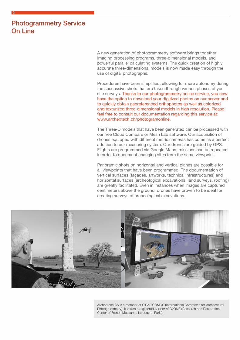
A new generation of photogrammetry software brings together imaging processing programs, three-dimensional models, and powerful parallel calculating systems. The quick creation of highly accurate three-dimensional models is now made easy through the use of digital photographs.
Procedures have been simplified, allowing for more autonomy during the successive shots that are taken through various phases of you site surveys. Thanks to our photogrammetry online service, you now have the option to download your digitized photos on our server and to quickly obtain georeferenced orthophotos as well as colorized and texturized three-dimensional models in high resolution. Please feel free to consult our documentation regarding this service at : www.archeotech.ch / photogramonline.
The Three-D models that have been generated can be processed with our free Cloud Compare or Mesh Lab software. Our acquisition of drones equipped with different metric cameras has come as a perfect addition to our measuring system. Our drones are guided by GPS. Flights are programmed via Google Maps ; missions can be repeated in order to document changing sites from the same viewpoint.
Panoramic shots on horizontal and vertical planes are possible for all viewpoints that have been programmed. The documentation of vertical surfaces ( façades, artworks, technical infrastructures ) and horizontal surfaces ( archeological excavations, land surveys, roofing ) are greatly facilitated. Even in instances when images are captured centimeters above the ground, drones have proven to be ideal for creating surveys of archeological excavations.
Archéotech SA is a member of CIPA/ ICOMOS ( International Committee for Architectural Photogrammetry ). It is also a registered partner of C2RMF ( Research and Restoration Center of French Museums, Le Louvre, Paris ).
3
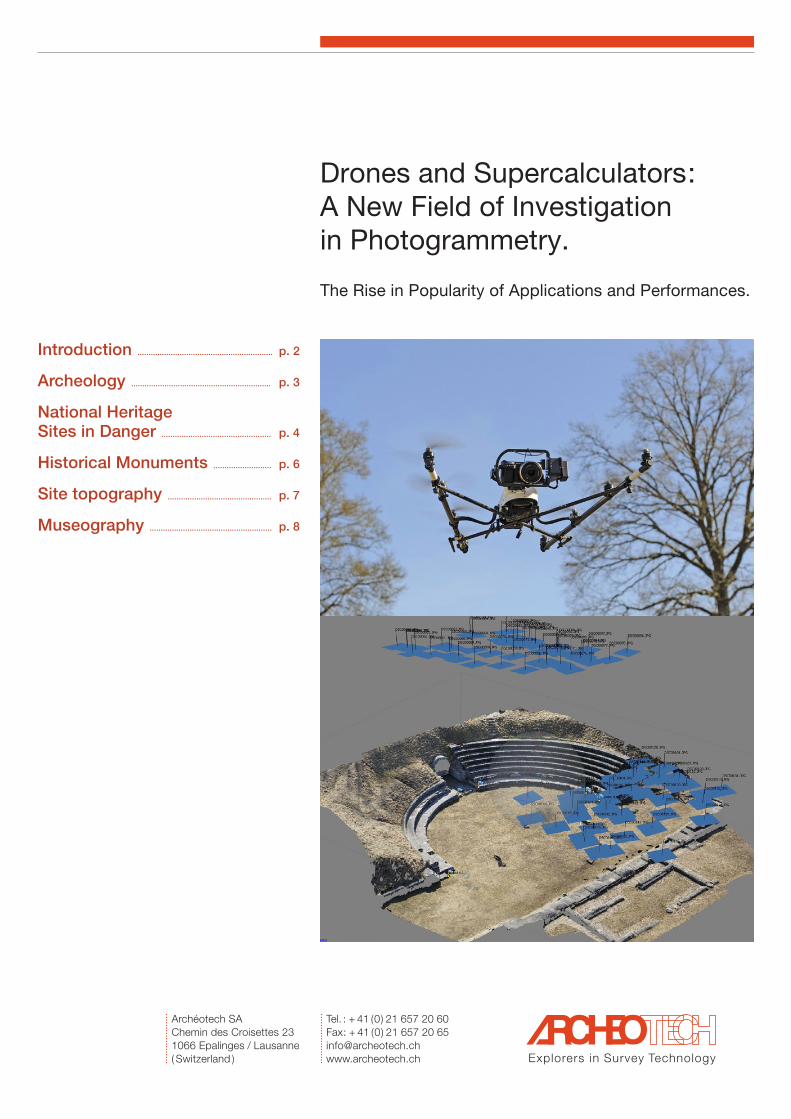
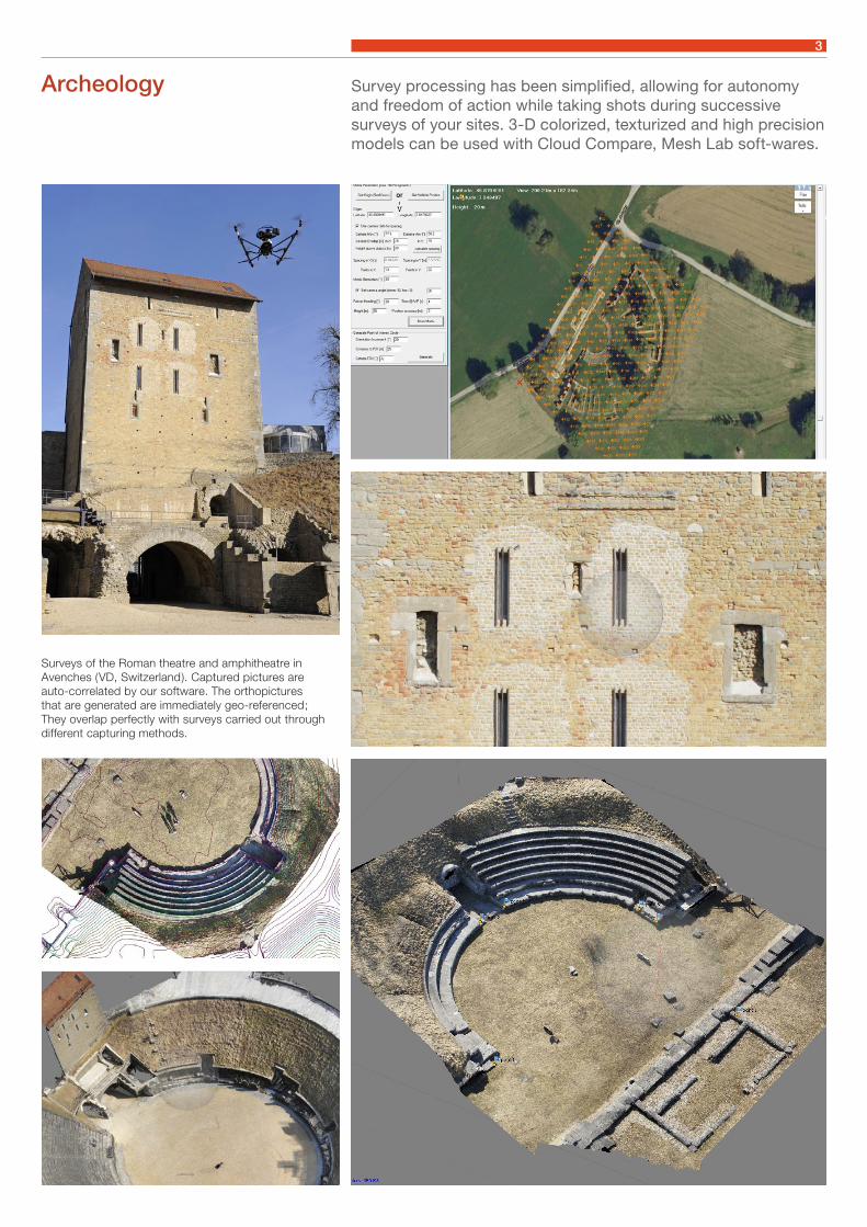
Archeology Survey processing has been simplified, allowing for autonomy and freedom of action while taking shots during successive surveys of your sites. 3-D colorized, texturized and high precision models can be used with Cloud Compare, Mesh Lab soft-wares.
Surveys of the Roman theatre and amphitheatre in Avenches ( VD, Switzerland ). Captured pictures are auto-correlated by our software. The orthopictures that are generated are immediately geo-referenced ; They overlap perfectly with surveys carried out through different capturing methods.
4
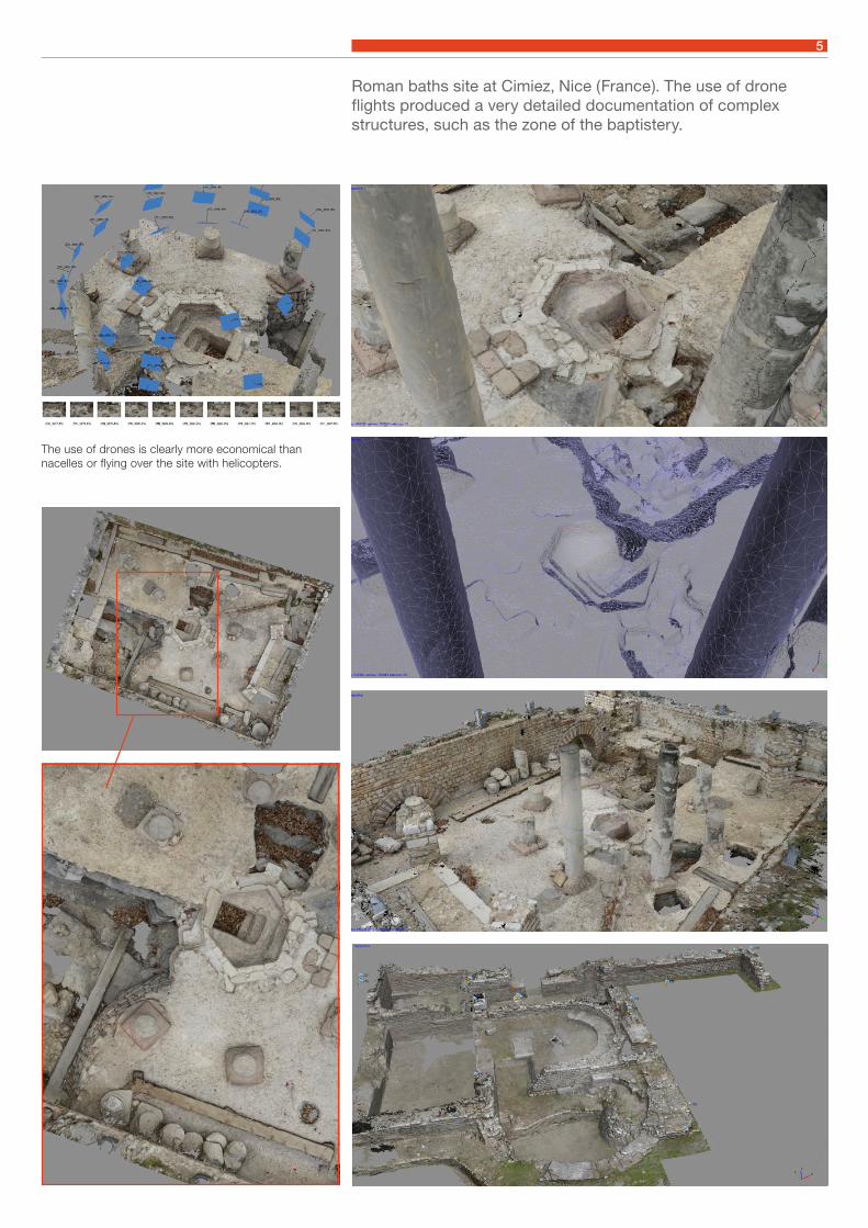
A site as extensive as the Roman baths at Cimiez, Nice ( France ), was surveyed in its entirety in just a few days. Tens of thousands of photographs were taken at ground level, using a drone.
National Heritage Sitesin Danger
Processed at our Parallel Data Calculations Center, the orthophoto plans, the elevation and the 3-D model of all the walls were generated with global infra-symmetric precision.
5
Roman baths site at Cimiez, Nice ( France ). The use of drone flights produced a very detailed documentation of complex structures, such as the zone of the baptistery.
The use of drones is clearly more economical thannacelles or flying over the site with helicopters.
6
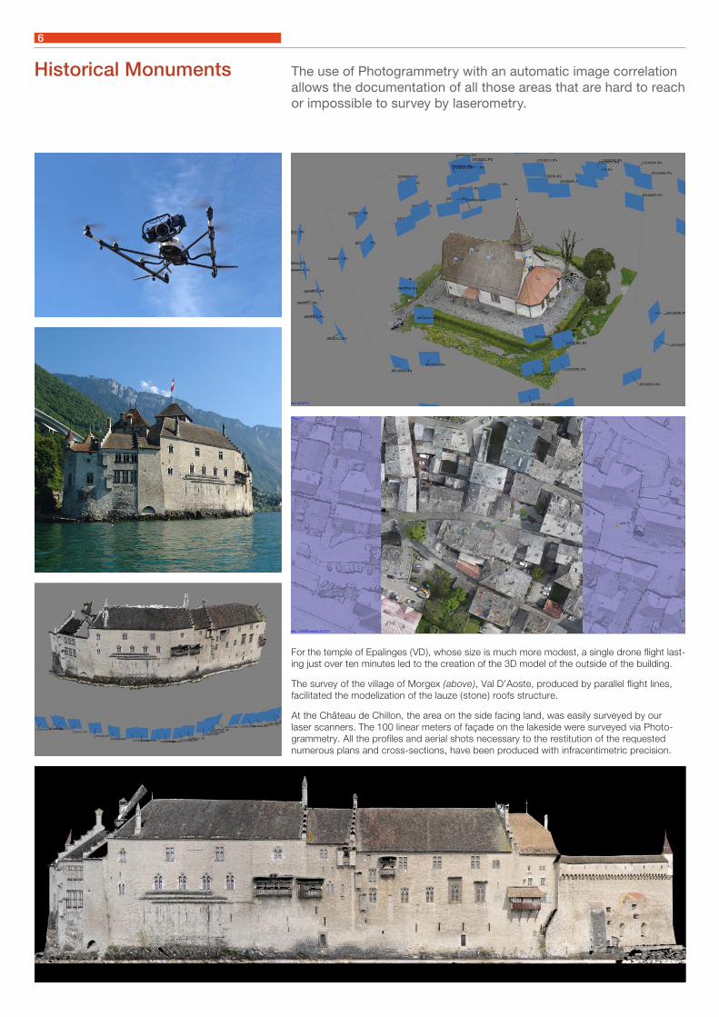
The use of Photogrammetry with an automatic image correlation allows the documentation of all those areas that are hard to reach or impossible to survey by laserometry.
For the temple of Epalinges ( VD ), whose size is much more modest, a single drone flight last-ing just over ten minutes led to the creation of the 3D model of the outside of the building.
The survey of the village of Morgex ( above ), Val D’Aoste, produced by parallel flight lines, facilitated the modelization of the lauze ( stone ) roofs structure.
At the Château de Chillon, the area on the side facing land, was easily surveyed by ourlaser scanners. The 100 linear meters of façade on the lakeside were surveyed via Photo-grammetry. All the profiles and aerial shots necessary to the restitution of the requested numerous plans and cross-sections, have been produced with infracentimetric precision.
Historical Monuments
7
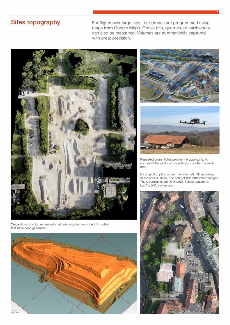
For flights over large sites, our drones are programmed using maps from Google Maps. Gravel pits, quarries, or earthworkscan also be measured. Volumes are automatically capturedwith great precision.
Calculations of volumes are automatically acquired from the 3D modelsthat have been generated.
Repeated drone flights provide the opportunity to document the evolution, over time, of a site or a work area.
By projecting photos over the automatic 3D modelingof the area of study, one can get true orthophoto images. Thus, parallaxes are eliminated. Below: Lausanne,La Cité ( VD, Switzerland ).
Sites topography
8
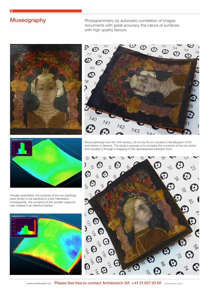
Museography Photogrammetry by automatic correlation of imagesdocuments with great accuracy the nature of surfaces,with high quality texture.
Wood paintings from the 15 th century, 35 cm by 40 cm, housed in the Museum of Artand History in Geneva. The study’s purpose is to compare the curvature of two art works and visualize it through a mapping of the discrepancies between them.
Virtually assembled, the surfaces of the two paintings were shown to be identical to a few millimeters ; consequently, the curvature of the wooden supportswas created in an identical fashion.