Page 1
OpenEarth
components in Data Science
some examples
Gerrit Hendriksen
Willem Stolte, Frank Keppel, Maarten Pronk, Dave de Koning,
Matthijs Schaap, Joan Sala, Anna van Gils, Kees den Heijer, Fedor
Baart, Johan Beekhuizen, Giorgio Santinelli, Almar Joling, Rens van
de Bergh, Amrit Cado van der Lelij, André Speelmans, Arthur van
Rooij, ….
Page 2
A small survey to start with
Go to Kahoot.it with your smartphone!
Page 3
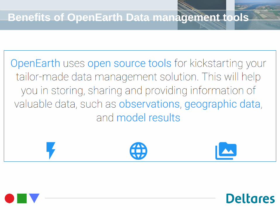
What is OpenEarth?
OpenEarth consists of Open Source tools to transform and
store your data in a standardized format. This enables you to
easily:
• Show the data in online viewers
• Help others find your data in online catalogues
• Share the data through an online download
• Store the changes in the data (version control)
Page 4
Benefits of OpenEarth Data management tools
Page 5
Data Stages
tailored
data
> WCS
> WFS
> SOS
> SOAP > netCDF-CF-
OPeNDAP
> ISO SQL–
PostGIS > SVN
> GIT
> http
> ftp
> KML
> WMS
> WFS
> CSW graphics
of data
standard
data
raw
data
catalogue
of data
work done
on server
work done
on client
what
where
when
who
why
how
…
data URLs
smart phone & tablet users scientists professionals
Page 6
Techniques - Basics
Page 7
Techniques - Basics
• OpenEarth:
• Open standards (OGC WxS)
• Open data
• Open source
• Web technology:
• Dissemination
• Interface between users and data
• Geoserver (OGC WxS)
• WPS
• Geonetwork (data discovery)
storage
(geo)database
OGC WxS services
dissemination
THREDDS netCDF
Page 8
Some examples
Where:
- Data management is unified
- Reuse of information
- Reuse of tools
Side information:
- Target audience
- Which data is used
- Which protocols
Page 10
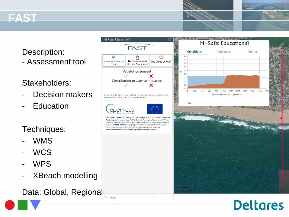
FAST
Description:
- Assessment tool
Stakeholders:
- Decision makers
- Education
Techniques:
- WMS
- WCS
- WPS
- XBeach modelling
Data: Global, Regional
Page 11
Expert version with regional data
Page 12
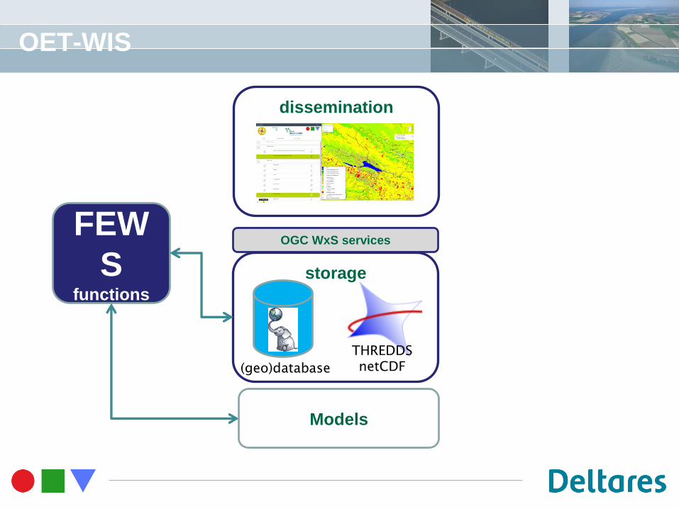
OET-WIS
Description:
Data management system for data intensive projects with:
- Time series (models, loggers, …)
- Geo data in various kinds
Stakeholders:
- Researchers, Clients
Data:
- Global, regional, local
Techniques:
- OGC services, FEWS, statistics, Mobile Apps
Page 13
OET-WIS
storage
(geo)database
OGC WxS services
dissemination
THREDDS netCDF
FEW
S functions
Models
Page 14
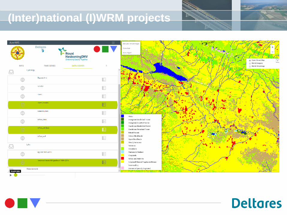
(Inter)national (I)WRM projects
Page 15
WIS animated results
Page 16
Waterviewer + NO3-app
Page 17
Hydrological Statistical Functions
Description:
- Hydrological statistical functions enabled by WPS builder
Stakeholders:
- Researchers, end users
Data
- Timeseries, geospatial
Techniques:
- WPS, OGC-WxS, Statistics
Page 18
Hydrological Statistical Functions
Page 19
Hydrological Statistical Functions
Page 20
Subsurface data handling
storage
(geo)database
OGC WxS services
THREDDS netCDF
dissemination
OGC WxS services
OGC WxS services (WPS)
Page 21
Subsurface Data Handling
Description:
- Central place for national (ground) water modelling data
Stakeholders:
- Researchers, Modellers, Waterboards, National government
Data
- National data for groundwater modelling and model results
Techniques:
- WPS, OGC-WxS
Page 22
Subsurface data handling
Page 23
Subsurface Examples - Infoline
Page 24
Subsurface Examples - Infoline
Page 25
Subsurface Examples - Infoline
dissemination
TNO - REGIS
THREDDS netCDF
OGC WxS services
OGC WxS services (WPS)
LHM/NHI
(GMDB)
THREDDS netCDF
OGC WxS services
Page 26
Subsurface Examples - Watersoils
Description:
- Risk assessment tool for water infrastructure
- Quick access to sub surface data
Stakeholders:
- Governmental researchers/engineers
Techniques:
- OPeNDAP
- WPS
Data:
- national, regional data
Page 27
Subsurface Examples - Watersoils
Page 28
Subsurface Examples - Watersoils
Page 29
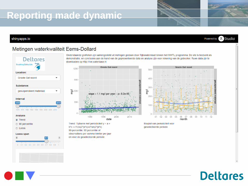
Dynamic Reporting
Description:
- Quick access to high level information on trends in …
Stakeholders:
- End users at governmental level
Techniques:
- (spatial)database
- R-shiny
Data:
- National, regional data
Page 30
Reporting made dynamic
Page 31
Reporting made dynamic
Page 32
Future work
Extensions:
- Reporting functions
- Statistical functions
- Running models
- Data entry modules
Attention to:
- User management
- security
Page 33
Message
Data acquisition
• Standardisation of data and metadata
• Standardised Processes to ‘create’/reuse data
• 3 clicks …
• Easy information dissemination
Main components of OpenEarth data systems:
• Central storage
• Knowledge exchange (i.e. statistical tools, Infoline)
• Highly standardised data formats
• Meta data
• Information and viewing services