31
DSR- AMRAVATI 1 A Detailed District Survey Report of Amravati Collector office; Amravati.

DSR- AMRAVATI
1
A Detailed
District Survey
Report of
Amravati
Collector office;
Amravati.
DSR- AMRAVATI
2
Index
Preface
1. Introduction
2. Overview of mining activity in the district
3. List of the Mining Leases in the district
4. Details of Royalty or Revenue received in last three
years
5. Details of Production of sand or minor mineral in last
three years
6. Deposition of sediments in the rivers of the district
7. General profile of the district
8. Land utilization pattern in the district
9. Physiography of the district
10. Rainfall
11. Geology and Mineral wealth
12. Major and Minor Rivers of the District
13. General recommendation
DSR- AMRAVATI
3
Preface
In Compliance to the Notification Issued by the Ministry Of
Environment, Forest and Climate change Dated 15.01.2016, the preparation
of District survey report of River bed mining and other minor minerals is in
accordance appendix 10 of the notification. It is also mentioned here that the
procedure of preparation of District Survey Report is as per notification
guidelines. Every efforts have been made to cover sand mining locations,
area & overview of mining activity in the district with all its relevant
features pertaining to geology & mineral wealth in replenish able and non-
replenish able areas of rivers, stream and other sand sources. This report will
be a model and guiding document which is a compendium of available
mineral resources, geographical set up, environmental and ecological set up
of the district and is based on data of various departments, published reports,
and websites. The data may vary due to floods, heavy rains and other natural
calamities. Therefore, it is recommended that Sub divisional Level
Committee may take into consideration all its relevant aspects/data while
scrutinizing and recommending the application for EC to the concerned
authority.
DSR- AMRAVATI
4
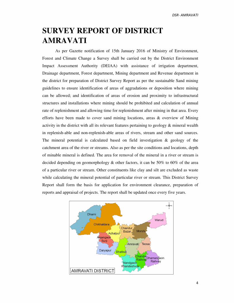
SURVEY REPORT OF DISTRICT
AMRAVATI
As per Gazette notification of 15th January 2016 of Ministry of Environment,
Forest and Climate Change a Survey shall be carried out by the District Environment
Impact Assessment Authority (DEIAA) with assistance of irrigation department,
Drainage department, Forest department, Mining department and Revenue department in
the district for preparation of District Survey Report as per the sustainable Sand mining
guidelines to ensure identification of areas of aggradations or deposition where mining
can be allowed; and identification of areas of erosion and proximity to infrastructural
structures and installations where mining should be prohibited and calculation of annual
rate of replenishment and allowing time for replenishment after mining in that area. Every
efforts have been made to cover sand mining locations, areas & overview of Mining
activity in the district with all its relevant features pertaining to geology & mineral wealth
in replenish-able and non-replenish-able areas of rivers, stream and other sand sources.
The mineral potential is calculated based on field investigation & geology of the
catchment area of the river or streams. Also as per the site conditions and locations, depth
of minable mineral is defined. The area for removal of the mineral in a river or stream is
decided depending on geomorphology & other factors, it can be 50% to 60% of the area
of a particular river or stream. Other constituents like clay and silt are excluded as waste
while calculating the mineral potential of particular river or stream. This District Survey
Report shall form the basis for application for environment clearance, preparation of
reports and appraisal of projects. The report shall be updated once every five years.
DSR- AMRAVATI
5
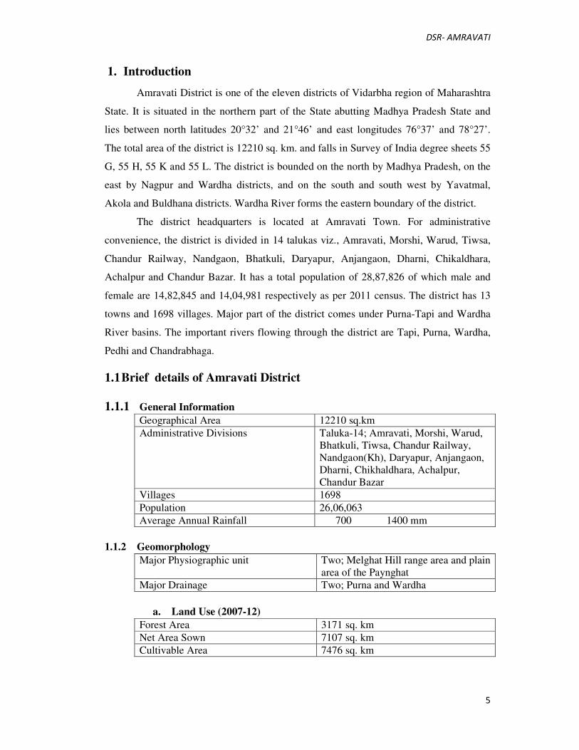
1. Introduction
Amravati District is one of the eleven districts of Vidarbha region of Maharashtra
State. It is situated in the northern part of the State abutting Madhya Pradesh State and
lies between north latitudes 20°32’ and 21°46’ and east longitudes 76°37’ and 78°27’.
The total area of the district is 12210 sq. km. and falls in Survey of India degree sheets 55
G, 55 H, 55 K and 55 L. The district is bounded on the north by Madhya Pradesh, on the
east by Nagpur and Wardha districts, and on the south and south west by Yavatmal,
Akola and Buldhana districts. Wardha River forms the eastern boundary of the district.
The district headquarters is located at Amravati Town. For administrative
convenience, the district is divided in 14 talukas viz., Amravati, Morshi, Warud, Tiwsa,
Chandur Railway, Nandgaon, Bhatkuli, Daryapur, Anjangaon, Dharni, Chikaldhara,
Achalpur and Chandur Bazar. It has a total population of 28,87,826 of which male and
female are 14,82,845 and 14,04,981 respectively as per 2011 census. The district has 13
towns and 1698 villages. Major part of the district comes under Purna-Tapi and Wardha
River basins. The important rivers flowing through the district are Tapi, Purna, Wardha,
Pedhi and Chandrabhaga.
1.1 Brief details of Amravati District
1.1.1 General Information
Geographical Area 12210 sq.km
Administrative Divisions Taluka-14; Amravati, Morshi, Warud,
Bhatkuli, Tiwsa, Chandur Railway,
Nandgaon(Kh), Daryapur, Anjangaon,
Dharni, Chikhaldhara, Achalpur,
Chandur Bazar
Villages 1698
Population 26,06,063
Average Annual Rainfall 700 1400 mm
1.1.2 Geomorphology
Major Physiographic unit Two; Melghat Hill range area and plain
area of the Paynghat
Major Drainage Two; Purna and Wardha
a. Land Use (2007-12)
Forest Area 3171 sq. km
Net Area Sown 7107 sq. km
Cultivable Area 7476 sq. km

DSR- AMRAVATI
6
b. Soil Type
Medium to deep black soil and deep brown to red soil (Regular).
c. Principal Crops (2007-12)
Cotton 3279.01 sq.km
Jowar 1181.00 sq.km
Oil seeds 1872.97 sq.km
Pulses 2188.00 sq.km
d. Irrigation by different sources (2007-12)
Nos/Potential Created (ha)
Dugwells 63791/147528
Tubewells/Borewells 691/1771
Tanks/Ponds 313/4603
Other Surface Sources 476/1465
Net Irrigated Area 65892 ha
e. Ground Water Monitoring Wells (As on 31/05/2016) source-GSDA
Dugwells 170
Piezometers 6
f. Geology
Recent Alluvium
Upper Cretaceous-Lower Ecocene Basalt (Deccan Traps)
Turonian Lameta Beds
Upper Carboniferous-Permian Gondwana
Archean Metamorphics (Gneisses/Granites)
g. Hydrogeology
Water Bearing Formation Basalt-weathered/fractured/jointed
Vesicular/massive, under phreatic and
semi-confined to confined conditions.
Alluvium-Sand and Gravel, under semi-
confined to confined conditions.
Premonsoon Depth to Water Level 8.5 to 26.90 m bgl
Postmonsoon Depth to Water Level 7.5 to 18.40 m bgl
h. Nature of Aquifers in Amravati District as per CGWB with potential
yield
S.No Taluka Main Aquifer Yield Potential Type of wells Remarks
Suiitable
1 Amravati Basalt Medium to
High
Dugwells
Borewells
2 Dharni Basalt Poor Dugwells Hilly Areas
3 Morshi Basalt Low to
Medium
Dugwells
Borewells

DSR- AMRAVATI
7
1.2 Location & Geographical Area:
The total geographical area of Amravati District is 12212 sq. km. and its only 3.97
% of Maharashtra. 75% of Amravati district covered by Deccan Trap while 25% area
covered by Purna alluvium. The global location of the district extends between 21.30' to
21.50' north latitude and 76.35' to 78.27' east longitude.
Amravati district is located in the Vidharbha region on the north eastern side of
the State of Maharashtra. It is bounded by the Khandwa and Betul districts of Madhya
Pradesh State on the north and by the Maharashtra districts of Nagpur on the northeast,
Wardha on the east, Yavatmal on the south, Washim on the southwest and Akola and
Buldhana districts on the west.
Connectivity: Railway
The Mumbai-Bhusaval-Nagpur-Kolkata broad gauge rail line, Murtijapur-
Achalpur, Khandwa-Akola-Purna and Badnera-Amravati meter gauge rail line run
through the district. These connect Amravati to the bigger cities of Mumbai, Jalgaon,
Nagpur, Delhi and Chennai.
Roadways
The National Highway 6 that runs between Hazira-Dhule-Kolkata passes through
the district, thus making markets accessible and helping trade and business in the district.
2 Overview of mining activity in the district
2.1 Mineral in Maharashtra
Maharashtra is the second largest producer of kyanite and the second largest
producer of manganese ore. The principal mineral-bearing belts in Maharashtra are
Vidarbha area in the east and konkan area in the west. Important mineral occurrences are:
bauxite in Kolhapur, Raigad, Ratnagiri, Satara, Sindhudurg & Thane districts; Chromite
in Bhandara, Chandrapur, Nagpur &Sindhudurg districts; coal in Nagpur, Chandrapur &
Yavatmal districts; fireclay in Amravati, Chandrapur, Nagpur & Ratnagiri districts;
fluorite & Shale in Chandrapur district; iron ore (haemtite) in Chandrapur, Ghadchiroli
and Sindhudurg districts; iron ore (magnetite) in Gondia district; kynaite in Bhandara&
Nagpur districts; laterite in Kolhapur district; limestone in Ahmednagar, Chandrapur,
Dhule, Gadchiroli, Nagpur, Nanded, Pune, Sangli & Yavatmal districts; manganese ore in
Bhandara, Nagpur & Ratnagiri districts; corundum & pyrophyllite in Bhandara district;
DSR- AMRAVATI
8
quartz & silica sand in Bhandara, Chandrapur, Gadchiroli, Gondia, Kolhapur, Nagpur,
Ratnagiri & Sindhudurg districts; and sillimanite in Bhandara and Chandrapur district.
Other minerals that occur in the state are: barytes in Chandrapur & Gadchiroli
districts; copper in Bhandara, Chandrapur, Gadchiroli& Nagpur districts; feldspar in
Sindhudurg district; gold in Bhandara, Chandrapur, Dhule, Gadchiroli, Nagpur, Nanded,
Nashik, Sindhudurg & Thane districts; graphite & mica in Sindhudurg district; lead-zinc
& tungsten in Nagpur district; marble in Bhandara& Nagpur districts; ochre in
chandrapur& Nagpur districts; silver & vanadium in Bhandara district; stealite in
Bhandara, Ratnagiri & Sindhudurg districts; and titanium minerals in Gondia & Ratnagiri
districts.
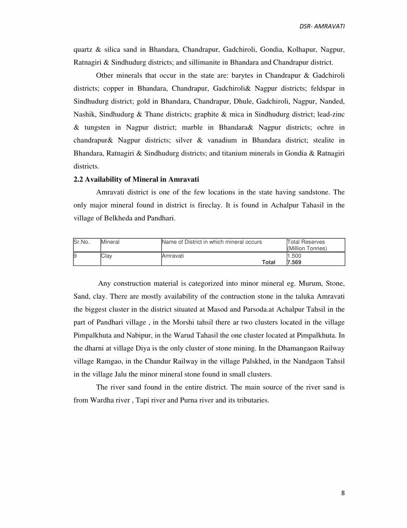
2.2 Availability of Mineral in Amravati
Amravati district is one of the few locations in the state having sandstone. The
only major mineral found in district is fireclay. It is found in Achalpur Tahasil in the
village of Belkheda and Pandhari.
Any construction material is categorized into minor mineral eg. Murum, Stone,
Sand, clay. There are mostly availability of the contruction stone in the taluka Amravati
the biggest cluster in the district situated at Masod and Parsoda.at Achalpur Tahsil in the
part of Pandhari village , in the Morshi tahsil there ar two clusters located in the village
Pimpalkhuta and Nabipur, in the Warud Tahasil the one cluster located at Pimpalkhuta. In
the dharni at village Diya is the only cluster of stone mining. In the Dhamangaon Railway
village Ramgao, in the Chandur Railway in the village Palskhed, in the Nandgaon Tahsil
in the village Jalu the minor mineral stone found in small clusters.
The river sand found in the entire district. The main source of the river sand is
from Wardha river , Tapi river and Purna river and its tributaries.
Sr.No. Mineral Name of District in which mineral occurs Total Reserves (Million Tonnes)
9 Clay Amravati Total
1.500 7.569
DSR- AMRAVATI
9
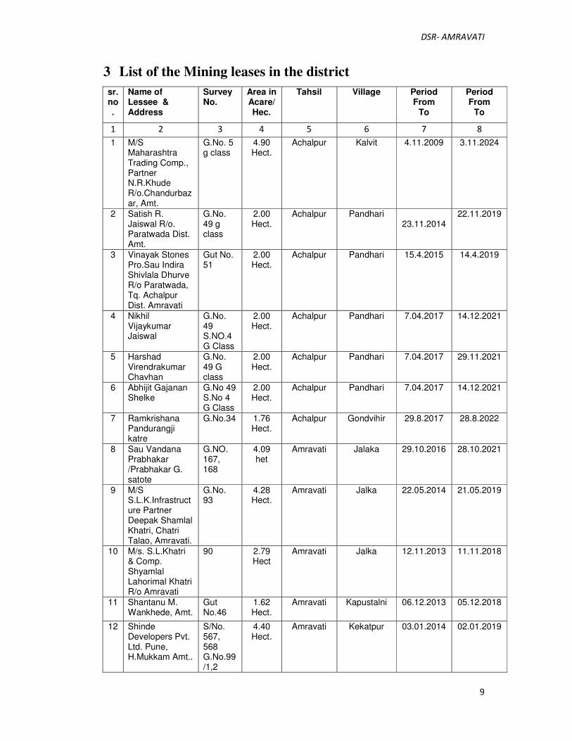
3 List of the Mining leases in the district
sr.no.
Name of Lessee & Address
Survey No.
Area in Acare/Hec.
Tahsil Village Period From
To
Period From
To
1 2 3 4 5 6 7 8
1 M/S Maharashtra Trading Comp., Partner N.R.Khude R/o.Chandurbazar, Amt.
G.No. 5 g class
4.90 Hect.
Achalpur Kalvit 4.11.2009 3.11.2024
2 Satish R. Jaiswal R/o. Paratwada Dist. Amt.
G.No. 49 g class
2.00 Hect.
Achalpur Pandhari 23.11.2014
22.11.2019
3 Vinayak Stones Pro.Sau Indira Shivlala Dhurve R/o Paratwada, Tq. Achalpur Dist. Amravati
Gut No. 51
2.00 Hect.
Achalpur Pandhari 15.4.2015 14.4.2019
4 Nikhil Vijaykumar Jaiswal
G.No. 49 S.NO.4 G Class
2.00 Hect.
Achalpur Pandhari 7.04.2017 14.12.2021
5 Harshad Virendrakumar Chavhan
G.No. 49 G class
2.00 Hect.
Achalpur Pandhari 7.04.2017 29.11.2021
6 Abhijit Gajanan Shelke
G.No 49 S.No 4 G Class
2.00 Hect.
Achalpur Pandhari 7.04.2017 14.12.2021
7 Ramkrishana Pandurangji katre
G.No.34 1.76 Hect.
Achalpur Gondvihir 29.8.2017 28.8.2022
8 Sau Vandana Prabhakar /Prabhakar G. satote
G.NO. 167, 168
4.09 het
Amravati Jalaka 29.10.2016 28.10.2021
9 M/S S.L.K.Infrastructure Partner Deepak Shamlal Khatri, Chatri Talao, Amravati.
G.No. 93
4.28 Hect.
Amravati Jalka 22.05.2014 21.05.2019
10 M/s. S.L.Khatri & Comp. Shyamlal Lahorimal Khatri R/o Amravati
90 2.79 Hect
Amravati Jalka 12.11.2013 11.11.2018
11 Shantanu M. Wankhede, Amt.
Gut No.46
1.62 Hect.
Amravati Kapustalni 06.12.2013 05.12.2018
12 Shinde Developers Pvt. Ltd. Pune, H.Mukkam Amt..
S/No. 567, 568 G.No.99/1,2
4.40 Hect.
Amravati Kekatpur 03.01.2014 02.01.2019
DSR- AMRAVATI
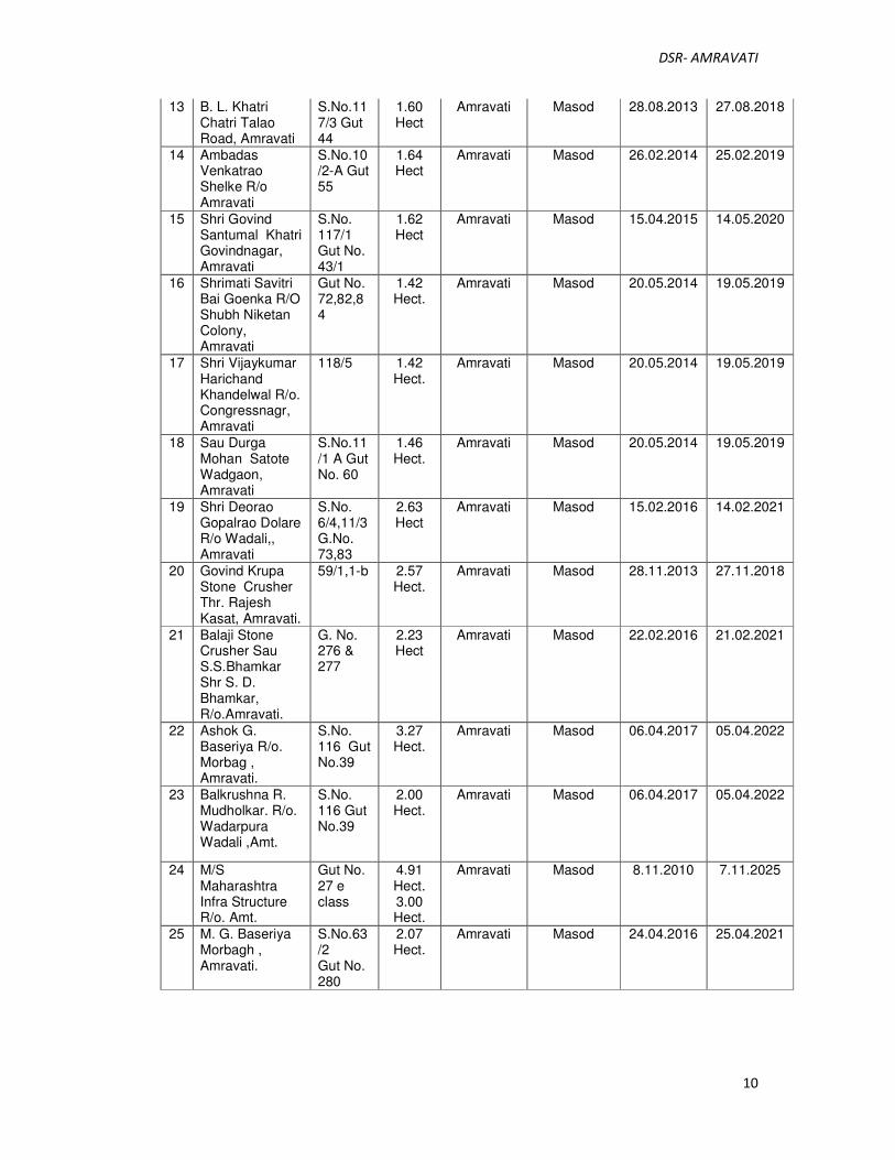
10
13 B. L. Khatri Chatri Talao Road, Amravati
S.No.117/3 Gut 44
1.60 Hect
Amravati Masod 28.08.2013 27.08.2018
14 Ambadas Venkatrao Shelke R/o Amravati
S.No.10/2-A Gut 55
1.64 Hect
Amravati Masod 26.02.2014 25.02.2019
15 Shri Govind Santumal Khatri Govindnagar, Amravati
S.No. 117/1 Gut No. 43/1
1.62 Hect
Amravati Masod 15.04.2015 14.05.2020
16 Shrimati Savitri Bai Goenka R/O Shubh Niketan Colony, Amravati
Gut No. 72,82,84
1.42 Hect.
Amravati Masod 20.05.2014 19.05.2019
17 Shri Vijaykumar Harichand Khandelwal R/o. Congressnagr, Amravati
118/5 1.42 Hect.
Amravati Masod 20.05.2014 19.05.2019
18 Sau Durga Mohan Satote Wadgaon, Amravati
S.No.11/1 A Gut No. 60
1.46 Hect.
Amravati Masod 20.05.2014 19.05.2019
19 Shri Deorao Gopalrao Dolare R/o Wadali,, Amravati
S.No. 6/4,11/3 G.No. 73,83
2.63 Hect
Amravati Masod 15.02.2016 14.02.2021
20 Govind Krupa Stone Crusher Thr. Rajesh Kasat, Amravati.
59/1,1-b 2.57 Hect.
Amravati Masod 28.11.2013 27.11.2018
21 Balaji Stone Crusher Sau S.S.Bhamkar Shr S. D. Bhamkar, R/o.Amravati.
G. No. 276 & 277
2.23 Hect
Amravati Masod 22.02.2016 21.02.2021
22 Ashok G. Baseriya R/o. Morbag , Amravati.
S.No. 116 Gut No.39
3.27 Hect.
Amravati Masod 06.04.2017 05.04.2022
23 Balkrushna R. Mudholkar. R/o. Wadarpura Wadali ,Amt.
S.No. 116 Gut No.39
2.00 Hect.
Amravati Masod 06.04.2017 05.04.2022
24 M/S Maharashtra Infra Structure R/o. Amt.
Gut No. 27 e class
4.91 Hect. 3.00 Hect.
Amravati Masod 8.11.2010 7.11.2025
25 M. G. Baseriya Morbagh , Amravati.
S.No.63/2 Gut No. 280
2.07 Hect.
Amravati Masod 24.04.2016 25.04.2021
DSR- AMRAVATI
11
26 Vinod Kaluram Mudholkar. R/o. Wadarpura Wadali ,Amt.
S.No. 10/2 Gut No.56
0.96 Hect.
Amravati Masod 24.04.2016 25.04.2021
27 Roshan Kishore Baseriya Morbagh , Amravati.
117/1 A Gutno. 43/2
3.48 Hect. .
Amravati Masod 13.05.216
12.05.2021
28 Sau. Sarala Arun Padole R/o Wadgaon Mahore, Tq.Dist. Amravati
S.No. 11/1 Gut No. 59
0.81 Hect.
Amravati Masod 31.3.2015 30.3.2019
29 Indrapal Panditrao Chaudhary
S.No. 61/5 Gut No. 272, 275
3.21 Hect.
Amravati Masod 31.3.2015 30.3.2019
30 Bipin Ghanshayamdasji Kasat
S.No 256
4.90 Hect.
Amravati Masod 04.03.2016 03.03.2021
31 Rajesh Ghanshyamdas Kasat
S.No 66/3, 68/1 G/NO 264
3.10 hect
Amravati Masod 04.03.2016 03.03.2021
32 Govind Santumal Khatri
G.No 44 Sno. 117/3 G.No 45 S.No 117/2
2.27 Hect
Amravati Masod 06.05.2016 05.05.2021
33 Sau Sarla Arun Padole
G No. 268 S.No 129/3
1.60 Hect
Amravati Masod 08.08.2016 07.08.2021
34 Sau Sunita K. Baseriya R/o. Morbag, Amravati.
G.No. 282 & 284
2.59 Hect.
Amravati Masod 12.7.2011 11.7.2016
35 Chaurasia Stone Industries Nilesh D. Chaurasia Chaprashipura, Amravati.
S.No.49/2 Gat No. 17 & 18
4.77 Hect.
Amravati Parsoda 13.06.2013 112.06.2018
36 Sau Rima. J. Malani Gatthani Compound, Amravati.
53 G.45 2.97 Hect.
Amravati Parsoda 15.1.2014 14.1.2019
37 Sau Dipali Vilas Pande Ambapeth, Amravati.
G.No. 71, 74
2.43 Hect.
Amravati Parsoda 20.01.2015 19.01.2020
38 Sau. Archana P. Bhende. R/o. Amravati
Gut No. 44, 53
1.87 Hect.
Amravati Parsoda 12.7.2016 11.7.2021
DSR- AMRAVATI
12
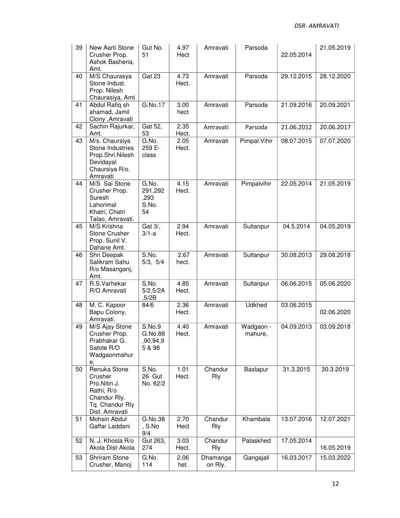
39 New Aarti Stone Crusher Prop. Ashok Basheria, Amt.
Gut No. 51
4.97 Hect
Amravati Parsoda 22.05.2014
21.05.2019
40 M/S Chaurasya Stone Indust. Prop. Nilesh Chaurasiya, Amt
Gat 23 4.73 Hect.
Amravati Parsoda 29.12.2015 28.12.2020
41 Abdul Rafiq sh ahamad, Jamil Clony ,Amravati
G.No.17 3.00 hect
Amravati Parsoda 21.09.2016 20.09.2021
42 Sachin Rajurkar, Amt.
Gat 52, 53
2.35 Hect.
Amravati Parsoda 21.06.2012 20.06.2017
43 M/s. Chaursiya Stone Industries Prop.Shri.Nilesh Devidayal Chaursiya R/o. Amravati
G.No. 259 E-class
2.05 Hect.
Amravati Pimpal Vihir 08.07.2015 07.07.2020
44 M/S Sai Stone Crusher Prop. Suresh Lahorimal Khatri, Chatri Talao, Amravati.
G.No. 291,292,293 S.No. 54
4.15 Hect.
Amravati Pimpalvihir 22.05.2014 21.05.2019
45 M/S Krishna Stone Crusher Prop. Sunil V. Dahane Amt.
Gat 3/, 3/1-a
2.94 Hect.
Amravati Sultanpur 04.5.2014 04.05.2019
46 Shri Deepak Salikram Sahu R/o Masanganj, Amt.
S.No. 5/3, 5/4
2.67 hect.
Amravati Sultanpur 30.08.2013 29.08.2018
47 R.S.Varhekar R/O Amravati
S.No. 5/2,5/2A ,5/2B
4.85 Hect.
Amravati Sultanpur 06.06.2015 05.06.2020
48 M. C. Kapoor Bapu Colony, Amravati.
84/6 2.36 Hect.
Amravati Udkhed 03.06.2015 02.06.2020
49 M/S Ajay Stone Crusher Prop. Prabhakar G. Satote R/O Wadgaonmahure,
S.No.9 G.No.88,90,94,95 & 98
4.40 Hect.
Amravati Wadgaon -mahure,
04.09.2013 03.09.2018
50 Renuka Stone Crusher Pro.Nitin J. Rathi, R/o Chandur Rly. Tq. Chandur Rly Dist. Amravati
S.No. 26 Gut No. 62/2
1.01 Hect.
Chandur Rly
Baslapur 31.3.2015 30.3.2019
51 Mohsin Abdul Gaffar Laddani
G.No.38, S.No 9/4
2.70 Hect
Chandur Rly
Khambala 13.07.2016 12.07.2021
52 N. J. Khosla R/o Akola Dist-Akola
Gut 263, 274
3.03 Hect.
Chandur Rly
Palaskhed 17.05.2014 16.05.2019
53 Shriram Stone Crusher, Manoj
G.No. 114
2.06 het.
Dhamangaon Rly.
Gangajali 16.03.2017 15.03.2022
DSR- AMRAVATI
13
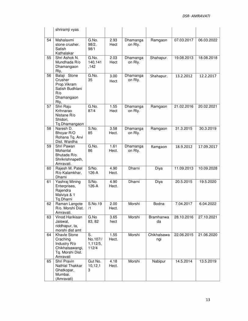
shriramji vyas
54 Mahalaxmi stone crusher. Satish Kathalakar
G.No. 98/2, 98/1
2.93 Hect
Dhamangaon Rly.
Ramgaon 07.03.2017 06.03.2022
55 Shri Ashok N. Mundhada R/o Dhamangaon Rly,
G.No. 140,141,142
2.03 Hect
Dhamangaon Rly.
Shahapur. 19.08.2013 18.08.2018
56 Balaji Stone Crusher Prop.Vikram Satish Budhlani R/o Dhamangaon Rly,
G.No. 35
3.00
Hect
Dhamangaon Rly.
Shahapur. 13.2.2012 12.2.2017
57 Shri Raju Krihnarao Nistane R/o Shidori, Tq.Dhamangaon
G.No. 87/4
1.55 Hect
Dhamangaon Rly.
Ramgaon 21.02.2016 20.02.2021
58 Naresh D. Bhoyar R/O Rohana Tq. Arvi Dist. Wardha
S.No. 85
3.58 Hect.
Dhamangaon Rly.
Ramgaon 31.3.2015 30.3.2019
59 Shri Pawan Mohanlal Bhutada R/o. Shrikrishnapeth, Amravati.
G.No. 86
1.61 Hect.
Dhamangaon Rly.
Ramgaon 18.9.2012 17.09.2017
60 Rajesh M. Patel R/o Kalamkhar, Dharni
S/No. 126-A
4.90 Hect.
Dharni Diya 11.09.2013 10.09.2028
61 Yashraj Mining Enterprises, Rajendra Malviya & 1 Tq.Dharni
S/No. 126-A
4.90 Hect.
Dharni Diya 20.5.2015 19.5.2020
62 Raman Langote R/o. Morshi Dist. Amravati.
S.No.19/1
2.00 Hect.
Morshi Bodna 7.04.2017 6.04.2022
63 Vinod Harikisan Jaiswal, riddhapur, ta, morshi dist amt
G.No 83, 82
3.65 hect
Morshi Bramhanwada
28.10.2016 27.10.2021
64 Khavle Stone Craching Industry R/o Chikhalsawangi, Tq. Morshi Dist. Amravati
S. No.107//1,112/5,112/4
1.55 Hect.
Morshi Chikhalsawangi
22.06.2015 21.06.2020
65 Shri Pravin Nathlal Thakkar Ghatkopar, Mumbai. (Amravati)
Gut No. 10,12,13
4.18 Hect.
Morshi Nabipur 14.5.2014 13.5.2019

DSR- AMRAVATI
14
66 Shri Jitendra Marotirao Bhawte R/o. Morshi, Dist-Amravati.
127/1 1.12 Hect.
Morshi Talni 17.02.2015
16.02.2020
67 Shri. Virendra Uttam Bhatkule R/o. Morshi Ta. Morshi
S. No. 127/1-B
1.01 Hect.
Morshi Talni 08.12.2014 07.12.2019
68 Shri. Umesh R. Mantri R/o. Morshi Ta. Morshi
S. No. 126/1,2,3
4.00 Hect.
Morshi Talni 24.5.2012 23.5.2017
69 Aditi Stone Crusher, Prakash Harikisan Rathi
G.No. 55/1
1.62 Hect.
Nand. kh Dahiagaon 6.04.2017 05.4.2022
70 Shri N V. Patel R/o Badnera Dist. Amravati.
43/3 2.50 Hect.
Nand. kh Jalu 22.04.2016 21.04.2021
71 Smt.Jayaben Ratilal Patel R/o Badnera, Amravati
S.No. 44/2
2.38 Hect
Nand. kh Jalu 31.10.2014 30.10.2019
72 Chirag Stone Crusher.. pp Raju Wanlhade At Amla ta Chandur Rly
S.No 77 3.00 Hect
Tiosa Vishnora 21.01.2015 20.01.2020
73 Shri. Abdul rafique Shaikh Ahmed R/o. Kurha Ta. Tiwsai
S. No. 13/4
1.80 Hect.
Tiwsa Kurha 7.09.2013 06.09.2018
74 Shri Girish R. Karale R/o. Warud Dist. Amravati.
G.No. 244 & 245
1.42
Hect.
Warud Ganeshpur 7.08.2011 6.08.2016
75 Laxman S. Belsare. R/o. Warud Dist. Amravati.
G.No. 97
1.00 Hect.
Warud Pimpalkhuta 07.04.2017 06.04.2022
76 Shri Ajay N. Watke R/o. Warud Dist. Amravati.
G.No. 97 f class
1.00 Hect.
Warud Pimpalkhuta 04.12.2016 03.12.2021

DSR- AMRAVATI
15
4 Details of Revenue received in last three years
Sr.No District Year Total Revenue received
(Rs. In Lakh)
1 Amravati 2015-16 8029.32
2 2016-17 7692.00
3 2017-18 7190.13
5 Details of Production of minor mineral in last three years
Sr.No District Year Production of Minor Mineral (in Brass)
1 Amravati 2015-16 2007330
2 2016-17 1923000
3 2017-18 1797500
6 Deposition of sediments in the rivers of the district
The deposition in a river bed is more pronounced during rainy season although the
quantum of deposition varies from stream to stream depending upon numbers of factors
such as catchment, lithology, discharge, river profile and geomorphology of the river
course. where annual deposition is much more even two to three meters, but it is noticed
that during flood season whole of the pit so excavated is completely filled up and as such
the excavated area is replenished with new harvest of minerals.
In order to calculate the mineral deposits in the stream beds, the mineral
constituents have been categorized as clay, silt, sand, bajri and boulder. However during
present calculation, the waste material i,e silt which vary from 10 to 20% in different
streams has also been included in the total production. Further the Survey of India Topo-
Sheets are used as base map to know the extent of river course. The mineral reserves have
been calculated only upto 2.50 meter depth although there are some portions in the river
beds such as channel bars, point bars and central islands where the annual deposition is
raising the level of river bed thus causing shifting of the rivers towards banks resulting in
to cutting of banks and at such locations, removal of this material upto the bed level is
DSR- AMRAVATI
16
essential to control the river flow in its central part to check the bank cutting. While
calculating the mineral potentials, the mineral deposits lying in the sub-tributaries of that
particular stream/river has not been taken into consideration. Since these mineral deposits
are adding annually to the main river, the mineral deposits will be much more.
7 General profile of the district
7.2 Flaura and Fauna
7.1.1 Forest
The district exhibits two distinct geographical regions, viz., the plain regions in
the east and south-east and the hilly regions of the Satpuda ranges in north and north-
west. The plain region is extensively cultivated and forests appear only in dotted,
scattered patches. The hilly region is an extensive block of compact forests called
Melghat and contains an abundance of rich teak trees. The percentage of the forest
area to total area in the district is 30.43, and is unevenly distributed.
Tree Forests.
These include the forests of Melghat capable of producing big-size teak and timber of
other type.
Minor Forests.
These include the forests in the outskirts of Melghat and those in the plain regions,
which are capable of producing small-size timber poles of teak, etc. These forests
also supply fire-wood, thorns and grass and serve as good pastures for grazing the
cattle.
7.1.2 Wild Animals
The physical features of the district arc distinguished into two marked tracts. In the
east and south are the intensively cultivated plain tracts, with scattered blocks of
forests. The portion in the north and north-west, called Melghat, comprises the hilly
terrain of the Gawilgad ranges of the Satpudas. The plain tracts contain open type of
forest, as a result of the biotic influences. The hilly region is a well-preserved
compact block of forest. The existence of the fauna has a direct relation with the
condition of the vegetation and the biotic influences. The plain tract is thus poor in
fauna, while the well-preserved forest of the hilly region is richly stocked with
different kinds of wild animals.
DSR- AMRAVATI
17
7.1.3 BIRDS
The birds of the district include most of the gaily plumaged varieties common
elsewhere, such as the golden orioles, the blue roller, the king-fisher and the little
green fly-catchers. They also include the painted and rock sand grouses, the peacock,
the jungle quail, the grey partridge, jungle fowl, green pigeon, crow, the large grey
and rain quail and the button quail. Pea fowls and jungle fowls are particularly
abundant in the Melghat forests in the valley of the Sipna river. Of the water birds the
ordinary varieties of duck and teal, as well as the varied assortment of cranes and
other shore birds are found.
In Melghat many rare birds like the black and orange fly catcher
(Ochromela nigrorufa),otherwise found in the Nilgiris and in Ceylon, are
seen. Cyornis Tickellia, Tickell's blue redbreast common in Central India are also
found here. Myio-phonus Horsfieldii - the Malbar whistling thrush is found near
Chikhaldara.
7.2 Agriculture
Agriculture is a key sector in the Amravati taluka. There are three harvesting
seasons for crop farming, namely kharif, rabi and summer. Kharif is the main
seasonal crop in the taluka. The kharif season commences from mid Juneupto the end
of November. The major kharif crops are cereals likejowar, bajari (millet), maka
(maize), pulses like tur, mug, udid, oilseeds like soybeans, bhuimug, til, suryaful
(sunflower) and cash crops like cotton. The average of cereal, pulses, oilseeds and
cotton is 7587, 12688 , 18122 and 18778 hectares respectively. The average kharip
crops cuttivation in Amravati taluka is 57175 hectares. Rabi season commences from
October and its major crops are wheat, harbhara (gram) and kardai (saf-flower). The
average rabi crops farming is 6853 hectares. Besides this orange orchards are
predominantly grown in the taluka. The average orange orchard farming are 2400
hectares.
7.3 Industry
In Amravati taluka there are three industrial areas, namely Satuma, new MIDC at
Gopal Nagar and adjacent areas and third ongoing Special Economic Zone (SEZ) at
Nandgaon peth. MIDC has developed large, medium and small-scale industries viz.
ginning and pressing, weaving and spinning, edible oils, chemicals, fertilizers, pulse
mills, pharmaceuticals, clay ware, woodcutting, paper, cement, silver jewellery, pans,

DSR- AMRAVATI
18
cement pipes, medicines, offset, printing, toffees, nylon ropes, wooden toys, stainless
steel, cashew nut, orange processing, honey collection, fruit and fish canning, metal
works.
Cottage Industry: Cleaning of cotton, making of seed oil of various kinds and
weaving are the important cottage industries in Amravati taluka.
Mining: Open cast quarry mining produced minor mineral such as gitti on large
scale by number of stone crushers at the village Rahatgaon, Masod and Wadgaon near
Amravati. This is one of the important industries catering the need of civil works.
Energy Sector: With actual ongoing work of thermal power plant in
NandgaonPeth SEZ significant development in energy sector in Amravati taluka took
place. The capacity of power plant is 550 MW.
7.4 DEMOGRAPHY
7.4.1 Population Profile
The study area comprises of 1997 villages of Amravati District. The total
population of the Amravati District is 2,888,445 accommodating in households 644,922
with an average households size of approx. 4 members per family.
7.4.2 Gender Distribution in the Buffer Zone
The males in Amravati District constitute 51.26% and females constitute 48.74%.
The gender ratio of the study area is 951.63 per thousand male.
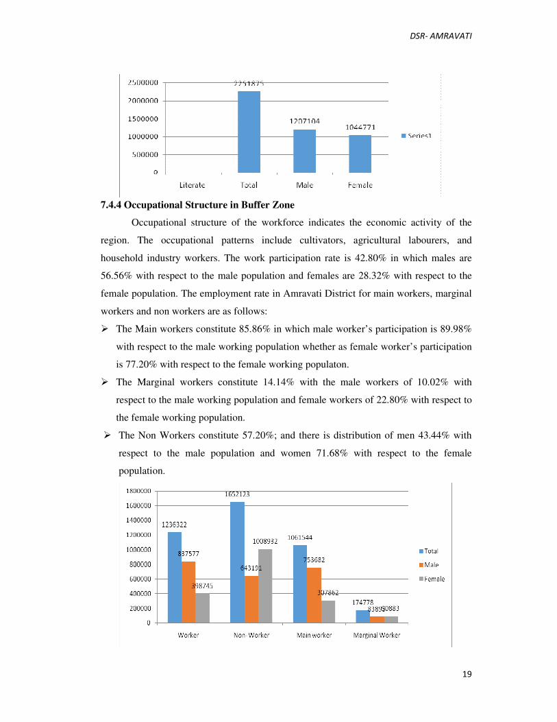
7.4.3 Literacy Profile in Buffer Zone
The average literacy rate of Amravati District is 77.96% as per Census of India,
2011. The male literacy is 81.51% with respect to male population and the female literacy
is 74.21% with respect to female population. The literacy gap between male & female is
approx. 7.3%. There are 22.04% people in our study area is illiterate.
DSR- AMRAVATI
19
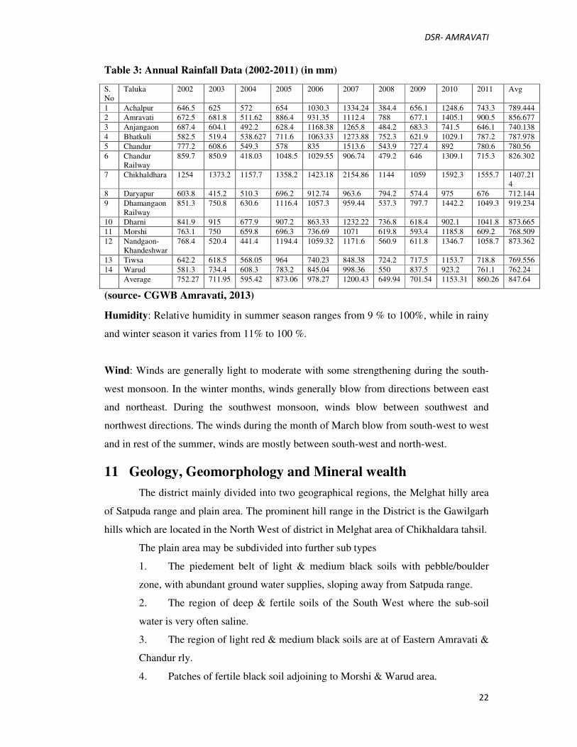
7.4.4 Occupational Structure in Buffer Zone
Occupational structure of the workforce indicates the economic activity of the
region. The occupational patterns include cultivators, agricultural labourers, and
household industry workers. The work participation rate is 42.80% in which males are
56.56% with respect to the male population and females are 28.32% with respect to the
female population. The employment rate in Amravati District for main workers, marginal
workers and non workers are as follows:
� The Main workers constitute 85.86% in which male worker’s participation is 89.98%
with respect to the male working population whether as female worker’s participation
is 77.20% with respect to the female working populaton.
� The Marginal workers constitute 14.14% with the male workers of 10.02% with
respect to the male working population and female workers of 22.80% with respect to
the female working population.
� The Non Workers constitute 57.20%; and there is distribution of men 43.44% with
respect to the male population and women 71.68% with respect to the female
population.

DSR- AMRAVATI
20
7.4.5 Demographic Profile of SC & ST in the Study Area
The total population of Schedule Caste in Amravati District is 506,374(17.53%) in
which 51.22% is male and 48.78% is female. The total population of Schedule Tribes in
Amravati District is 404,128 (13.99%) in which 50.93% is male and 49.07% is female.
8 Land utilization pattern in the district
The land use / land cover pattern of any region is an outcome of natural and socio
- economic factors and their utilization by man in time and space. Land is becoming a
limited resource due to immense agricultural and demographic pressure. Hence,
information on land use land cover and possibilities for their most advantageous use is
essential for the selection, planning and implementation of land use schemes to meet the
increasing demands for basic human needs and welfare. This information also assists in
monitoring the dynamics of land use resulting out of changing demands of increasing
population.
The present land use land cover pattern of Amravati taluka is as under urban
residential built up - 33.31 sq.km., villages (rural) built up - 9.62 sq.km., agriculture land-
591 .96 sq.km., forest- 99.83 sq .km., land with and without scrub - 154.99 sq.km., water
bodies mask - 8.10 sq.km. and river island- 0.19 sq.km.

DSR- AMRAVATI
21
9 Physiography of the district
The total geographical area of Amravati District is 12212 sq. km.and its only 3.97
% of Maharashtras. 75% of Amravati district covered by Deccan Trap while 25% area
covered by Purna alluvium. The total area of Purna alluvium is 3053 sq.kms. out of which
1562 sq.kms area belongs to saline zone which is Quality affected area. The ground water
in this area is not used for Irrigation and Drinking water purposes, where as North East
part of district there is high irrigation activity mainly orange fruit crop which develop
imbalance in ground water.
Physiography: Physiographically the taluka has been divided in two units. The
first drained by the Wardha and the second by Puma river basin marking the water divide.
Wardha basin gets separated through the Pohra hill range and the plain area of the
Pedhiriver. The Pohra hills forms part of the Sahyadri hill ranges are made up of Deccan
Trap Basalts. The eastern part of taluka falls under the Wardha River basin, whereas the
western and north western part falls in the Puma basin. The Purna basin consists of the
Pedhi river sub-basin. The valley is almost uniform in characteristics. Except the low
range of stony and barren hills which crop up in the immediate vicinity of Amravati
camp, which extends over the eastern border of the taluka. The Eastern and South eastern
part of taluka is covered by Pohra hill ranges and a fair jungle, and the North-East part of
taluka is covered by NerPinglai hills with scrub forest.
10 Rainfall
The Climate of the district is characterised by a hot summer and general dryness
throughout the year except during the south-west monsoon season, i.e., June to
September. The mean minimum temperature is 15.1°C and means maximum temperature
is 42.2°C.
The normal annual rainfall over the district varies from 700 mm to about 1700
mm. It is the minimum in the south western parts of the district around Daryapur (709
mm). This increases towards north and reaches a maximum in the northern part around
Chikaldhara (1647 mm). The average rainfall for the last ten years ranges from 712 mm
(Daryapur) to 1407 mm (Chikhaldhara). The average annual rainfall for the last ten years
when compared with the normal annual rainfall, it is observed that the average annual
rainfall for the last ten years of the district is much less than the normal annual rainfall.
Thus the rainfall has definitely decreased in the district over the period of time.
DSR- AMRAVATI
22
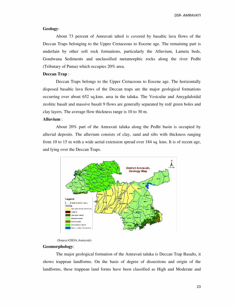
Table 3: Annual Rainfall Data (2002-2011) (in mm)
S.
No
Taluka 2002 2003 2004 2005 2006 2007 2008 2009 2010 2011 Avg
1 Achalpur 646.5 625 572 654 1030.3 1334.24 384.4 656.1 1248.6 743.3 789.444
2 Amravati 672.5 681.8 511.62 886.4 931.35 1112.4 788 677.1 1405.1 900.5 856.677
3 Anjangaon 687.4 604.1 492.2 628.4 1168.38 1265.8 484.2 683.3 741.5 646.1 740.138
4 Bhatkuli 582.5 519.4 538.627 711.6 1063.33 1273.88 752.3 621.9 1029.1 787.2 787.978
5 Chandur 777.2 608.6 549.3 578 835 1513.6 543.9 727.4 892 780.6 780.56
6 Chandur
Railway
859.7 850.9 418.03 1048.5 1029.55 906.74 479.2 646 1309.1 715.3 826.302
7 Chikhaldhara 1254 1373.2 1157.7 1358.2 1423.18 2154.86 1144 1059 1592.3 1555.7 1407.21
4
8 Daryapur 603.8 415.2 510.3 696.2 912.74 963.6 794.2 574.4 975 676 712.144
9 Dhamangaon
Railway
851.3 750.8 630.6 1116.4 1057.3 959.44 537.3 797.7 1442.2 1049.3 919.234
10 Dharni 841.9 915 677.9 907.2 863.33 1232.22 736.8 618.4 902.1 1041.8 873.665
11 Morshi 763.1 750 659.8 696.3 736.69 1071 619.8 593.4 1185.8 609.2 768.509
12 Nandgaon-
Khandeshwar
768.4 520.4 441.4 1194.4 1059.32 1171.6 560.9 611.8 1346.7 1058.7 873.362
13 Tiwsa 642.2 618.5 568.05 964 740.23 848.38 724.2 717.5 1153.7 718.8 769.556
14 Warud 581.3 734.4 608.3 783.2 845.04 998.36 550 837.5 923.2 761.1 762.24
Average 752.27 711.95 595.42 873.06 978.27 1200.43 649.94 701.54 1153.31 860.26 847.64
(source- CGWB Amravati, 2013)
Humidity: Relative humidity in summer season ranges from 9 % to 100%, while in rainy
and winter season it varies from 11% to 100 %.
Wind: Winds are generally light to moderate with some strengthening during the south-
west monsoon. In the winter months, winds generally blow from directions between east
and northeast. During the southwest monsoon, winds blow between southwest and
northwest directions. The winds during the month of March blow from south-west to west
and in rest of the summer, winds are mostly between south-west and north-west.
11 Geology, Geomorphology and Mineral wealth
The district mainly divided into two geographical regions, the Melghat hilly area
of Satpuda range and plain area. The prominent hill range in the District is the Gawilgarh
hills which are located in the North West of district in Melghat area of Chikhaldara tahsil.
The plain area may be subdivided into further sub types
1. The piedement belt of light & medium black soils with pebble/boulder
zone, with abundant ground water supplies, sloping away from Satpuda range.
2. The region of deep & fertile soils of the South West where the sub-soil
water is very often saline.
3. The region of light red & medium black soils are at of Eastern Amravati &
Chandur rly.
4. Patches of fertile black soil adjoining to Morshi & Warud area.
DSR- AMRAVATI
23
Geology:
About 73 percent of Amravati tahsil is covered by basaltic lava flows of the
Deccan Traps belonging to the Upper Cretaceous to Eocene age. The remaining part is
underlain by other soft rock formations, particularly the Alluvium, Lameta beds,
Gondwana Sediments and unclassified metamorphic rocks along the river Pedhi
(Tributary of Puma) which occupies 20% area.
Deccan Trap :
Deccan Traps belongs to the Upper Cretaceous to Eocene age. The horizontally
disposed basaltic lava flows of the Deccan traps are the major geological formations
occurring over about 652 sq.kms. area in the taluka. The Vesicular and Amygdaloidal
zeolitic basalt and massive basalt 9 flows are generally separated by red/ green boles and
clay layers. The average flow thickness range is 10 to 30 m.
Alluvium :
About 20% part of the Amravati taluka along the Pedhi basin is occupied by
alluvial deposits. The alluvium consists of clay, sand and silts with thickness ranging
from 10 to 15 m with a wide aerial extension spread over 184 sq. kms. It is of recent age,
and lying over the Deccan Traps.
(Source:GSDA,Amravati)
Geomorphology:
The major geological formation of the Amravati taluka is Deccan Trap Basalts, it
shows trappean landforms. On the basis of degree of dissections and origin of the
landforms, these trappean land forms have been classified as High and Moderate and
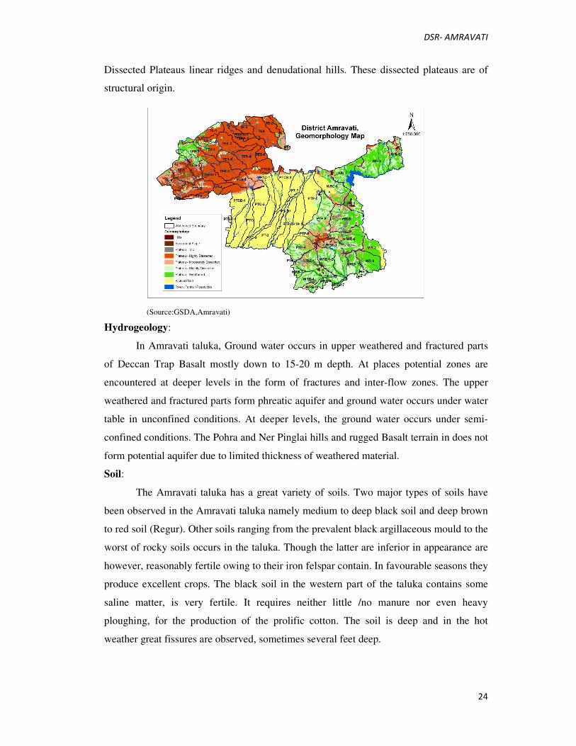
DSR- AMRAVATI
24
Dissected Plateaus linear ridges and denudational hills. These dissected plateaus are of
structural origin.
(Source:GSDA,Amravati)
Hydrogeology:
In Amravati taluka, Ground water occurs in upper weathered and fractured parts
of Deccan Trap Basalt mostly down to 15-20 m depth. At places potential zones are
encountered at deeper levels in the form of fractures and inter-flow zones. The upper
weathered and fractured parts form phreatic aquifer and ground water occurs under water
table in unconfined conditions. At deeper levels, the ground water occurs under semi-
confined conditions. The Pohra and Ner Pinglai hills and rugged Basalt terrain in does not
form potential aquifer due to limited thickness of weathered material.
Soil:
The Amravati taluka has a great variety of soils. Two major types of soils have
been observed in the Amravati taluka namely medium to deep black soil and deep brown
to red soil (Regur). Other soils ranging from the prevalent black argillaceous mould to the
worst of rocky soils occurs in the taluka. Though the latter are inferior in appearance are
however, reasonably fertile owing to their iron felspar contain. In favourable seasons they
produce excellent crops. The black soil in the western part of the taluka contains some
saline matter, is very fertile. It requires neither little /no manure nor even heavy
ploughing, for the production of the prolific cotton. The soil is deep and in the hot
weather great fissures are observed, sometimes several feet deep.

DSR- AMRAVATI
25
12 Details of Major and Minor Rivers in the District
Large rivers like Purna, Wardha, Tapi, Sipna and smaller rivers like Kapra,
Gadga, Chudaman and Kholat flow through the district. Wardha River marks the eastern
boundary of the district and the Tapi River its northern boundary.
The Wardha River forms the eastern boundary of the district, and the eastern
portion of the district lies within its watershed. The Purna River drains the southwestern
portion of the district, while the northwest is drained by the Tapti River. Other important
rivers are Shahanoor and Chandrabhaga.
The Purna rises near Bhainsdehi in Betul district of Madhya Pradesh in the
Satpudas. After flowing for about 50 km in a general southerly and south-easterly
direction enters the district. It travels across the district in a south-westerly direction
dividing it into two halves, first through the Achalpur taluka and then along the boundary
between the Amravati and Daryapurtalukas. Finally, it turns due westwards forming the
boundary of the district and continues further to join the Tapti
near Muktainagar in Jalgaon district. The only significant left bank tributary of the Purna
is the Pedhi. The first of the principal right bank tributaries is the Arna. The next is a
small river known as the Bodi. The next tributary, the Chandrabhaga is a very important
one, flowing in a general south-westerly direction to join the Purna. The principal right
bank affluent of the Chandrabhaga is the Bhuleshwari. The westernmost tributary of the
Purna of some significance within the district is the Shahanur, with its tributary, the
Bordi.
Purna.
The Purna, the largest of them rises near Bhainsdehi in Betul district of Madhya
Pradesh at a height of just over 760 metres in the Satpudas and after flowing for some 50
kilometres in a general southerly and south-easterly direction through the hills enters the
district emerging into the plains, as the district boundary here lies along the base of the
hills. It traverses across the plains of the district in a south-westerly direction dividing it
into two halves, first through the Achalpur tahsil and then along the boundary between
the Amravati and Daryapur tahsils. Then it turns due westwards forming the boundary of
the district and continues further to join the Tapi in Nimar district. On the banks of the
Purna are found a string of villages beginning from Vishroli near the foot of the Satpudas
and at close intervals of less than 3 kilometres lower down from Deurwada, situated near

DSR- AMRAVATI
26
the confluence with the Arna. The chief among them are Assegaon, Thugaon and
Kholapur.
Pedhi.
The only important left bank tributary of the Purna is the Pedhi. It rises in the low
hills near Rithpur and receives a number of small affluents both from the east and the
west, the chief on the west being the Naghirariver. The Pedhi flows in a general south-
easterly course passing by Walgaon and Bhat-kuli. After crossing the district boundary it
turns and flows westwards and north-westwards to join the Purna at the point where the
latter makes a very short sojourn outside the Amravati district into Akola.
Arna.
The first of the principal right bank affluents of the Purna is the Arna which
emerges from the Satpuda hills in Betul district and flows in a south and south-easterly
direction passing by Sirasgaon to join the Purna just below Deurwada.
Bodi.
The next affluent is a small river known as the Bodiriver, which after passing by
Talegaon joins the Purna at Rajna.
Chandrabhaga.
With its affluents, the Pili or Bahramkasand on which is situated the village of
Karasgaon, the Bichan river passing through Paratwada, the Sapan river passing through
Achalpur, the Chandrabhaga river is a very important tributary flowing in a general south-
westerly direction past Wasni, Khallar and Daryapur to join the Purna about a kilometre
and a half below Dhamodi. The river rises just below the Vairat plateau and after
receiving a number of small streams draining the southern slopes of the Chikhaldara
plateau and the slopes of the Gawilgad plateau, flows in an easterly direction in a valley
which forms a cultivated tract of about 2 kilometres in width breaking the continuity of
the forested areas on either side. About 2½ km. south-west of Dhamangaon it turns
southwards. The principal right bank affluent of the Chandrabhaga is the
Bhuleshwaririver which itself receives the Gangadari river, another Satpuda stream. The
Bhuleshwari passes by ShindiBuzrug and Kokarda and meets the Chandrabhaga near
Daryapur east of Babli.
Shahanur.
The westernmost tributary of the Purna of some importance within the district is
the Shahanurriver with its affluent, the Bordi. The Shahanur river rises in the Gawilgad
hills near Jhiraghat and after a fairly long and winding course first eastwards and then

DSR- AMRAVATI
27
south-westwards enters the plains near Malkapur and flows southwards passing by
Anjangaon and turns south- westwards at Umri and continues in this direction to join the
Purna beyond the border of the district.
Bordi.
Though the river Bordi flows for a major part of its course outside the district, it
is joined by the combined waters of the Chansuri river and the Gaimuk which have their
plain courses within the district.
Wardha.
The Wardha river rises to the east of Multai in Madhya Pradesh and has a long
and tortuous course along the Satpuda hills. It forms the eastern boundary of the district
and receives a number of short tributaries on its right flowing within the district. The
Saktiriver rises in Shendari reserved forest area in the Satpudas, and passing by Jarud and
flowing southwards joins the Wardha. The Dhawagiri river rises in the Dabka reserved
forest area and flows past Benoda and Loni before joining the Wardha.
Pak Nala.
The Pak Nala rises in the same Dabka forest area and receives, besides the
Satpudaaffluents, the drainage of the northern slopes of Lakhara hills, a detached mass
south of the Satpudas. Hiwarkhed is situated on the banks of this river. The Pak Nala
Project on this river provides irrigation facilities to the area on the northern side of the
Morshi-Warud road. The Kobi drains the southern slopes of the Lakhara hills into the
Wardha.
Maru.
The Maru river rises south of Atner in Betul district and after a winding course in
the Satpudas enters the district and flows in a general south-easterly course to join the
Wardha, where the latter makes an abrupt right angular turn to continue the course of the
Maru.
Narha.
The Narha river is a much smaller but important tributary of the Wardha. Morshi,
the tahsil headquarters, is situated on its western bank.
Chargar.
The westernmost tributary of some size flowing from the Satpudas is the Chargar
river having its source just east of the Wardha-Purna watershed, and flows past
GhatLarki, Khed, and Udkhed with a general south-easterly direction parallel to the water
divide and joins the Wardha at Bhambor. The river Chargar receives the Kasiriver, a

DSR- AMRAVATI
28
smaller stream flowing somewhat parallel to it on its western side from the north, and also
the combined waters of the Dhaula, the Lendi and the Bharan-takia from the Ner hills in
the south-west. NerPingalai village is situated between the Lendi and the Bharantakia.
Minor Rivers.
There are several small streams flowing eastwards from the Wardha-Purna water
divide into the Wardhariver. Among them is the river NerPingalai on which are located
Talegaon, Thakur and Tivsa. The Borriver passing by Kurha and Idarba river passing by
Temburni, Virul and Anjansinghi river join together and flow into the Wardha. The
Kolad-Dhangarriver flowing roughly parallel to the Wardha on its western side passes by
Mangrul and joins it at Borgaon in the south-east corner of the district. The
Chandrabhagariver (this should not be confused with the much larger one of the same
name flowing by Daryapur) flows by Dattapur in an easterly direction and then turns
southwards to join the Wardha outside the district. The last of the tributaries of the
Wardha in the district is the Bemla which has only its middle course in the extreme
southern part of the district, but is important as receiving a number of affluents flowing
from the north, such as the Kholad and the Chandrabhaga (the third one in the district
with the same name) flowing by Chandur Railway and the Kalamali.
Purna-Wardha Water Divide.
The water divide between the Purna and the Wardha system of rivers (in fact this
is the water divide between the Tapi flowing into the Arabian Sea and the Godavari
flowing into the Bay of Bengal as the former two are only tributaries of the latter) begins
in the district at the foot hills of the Satpudas and runs as a low divide of a little more than
360 metres in elevation in a general south-easterly direction with peaks on it rising to 404
metres east of Pohenkheda and to 435 metres in Ner hills. From the Ner hills it turns and
runs in a south-westerly direction somewhat parallel to the Morshi-Amravati road with
peak heights of 387 metres and 392 metres, and in the hills east of Amravati with peaks
over 460 metres. The water divide continues in the south-westerly direction with a lower
height (350 metres at Loni) and passes outside the district. By comparing the levels of the
beds of the Purna and the Wardha it is seen that the maximum relative relief is not
generally more than 100 metres, indicative of post-mature stage of dissection. It may be
mentioned here that the initial south-easterly course of the divide changing into a south-
westerly trend is also reflected in the courses of the several tributaries of the Purna system
within the district.

DSR- AMRAVATI
29
Tapi Tributaries.
As the highest hills of the Melghat are in its southern part the water divide
between the south flowing tributaries of the Purna and the north flowing tributaries of the
Tapi lies towards the southern part of the Melghat hills, so that the greater part of Melghat
is drained northwards and northeastwards towards the Tapi river. The more important
among them are the Khursi, the Khandu, the Sipna, the Garga, the Dewal and the
Dhulghat. The Khursiriver takes its source on the eastern slopes of Katkumbh plateau and
after a brief sojourn into the Betul district re-enters the district and flows in a north-
westerly direction flowing close to the district boundary for some distance and then
follows it for a while till it leaves it to flow northwards to join the Tapi. The Khandu
rising near Khamla in Betul district enters the district to flow west of the Katkumbh
plateau and has a fairly long and winding course in a general north-westerly direction
cutting its bed deeply through the several ranges of hills, before joining the Tapi just
outside the district. The Khapra has its source just outside the district on the northern
slopes of the Antarmal plateau of Betul district and has a similar winding course through
the hills to join the Tapi outside the district. The Sipna rises very close to the source of
the Khapra and has a similar long winding but westerly course towards the Tapi. But
unlike the aforesaid rivers the Sipna has several flat stretches of land adjoining its middle
and lower courses useful for the purposes of cultivation supporting such villages as
Harisal, Chakarda and Duni. The Garga rises on the northern slopes of the Gawilgad ridge
west of the Vairat plateau and is joined by the Kutumbi at Koha and has a general
westerly and northwesterly course passing by Kalamkhar and Dhulghat to join the Tapi.
This river is even more important than the Sipna, for the lower valley below GargaMalur
is an extensive level area, richly cultivated, forming the Dharni plain which reaches up to
Sipna on the north at Diwa. The Dewal and Dhulghat rivers are two smaller streams
which have their sources in the Gawilgad ridge farther to the west of the others and have
their lower plain courses near the Tapi.
13 General Recommendations/Conclusions
During the preparation of the present report prominent rivers/ streams has been
studied in detail, as the rest of the streams/rivers either have very insignificant annual
replenishment/ approachability problem or are very narrow at most of the places and as
such are not fit for grant of mineral concession for mineral based industries, however it is
DSR- AMRAVATI
30
also important to mention here that because of the regular demand of sand, stone and bajri
for the developmental activities in the respective areas, such streams are prone to illegal
mining, It is suggested that the auctions of quarries be done regularly to meet out the local
demand subject to the approval from the joint Inspection Committee as per New Sand
mining guidelines, Maharashtra (03/01/2018) .These mineral concessions shall also
reduce demand load and will be helpful to minimize illegal extraction of minerals, failure
of which may result in to illegal mining at odd hours and shall be haphazard and more
detrimental to the local ecology. Irrespective of it following geo-scientific considerations
are also suggested to be taken into account during the river bed mining in a particular
area:
1. Abandoned stream channels or terrace and inactive floodplains may be preferred
rather than active channels and their deltas and floodplains.
2. Stream should not be diverted to form inactive channel.
3. Mining below subterranean water level should be avoided as a safeguard against
environmental contamination and over exploitation of resources.
4. Large rivers and streams whose periodic sediment replenishment capacities are
larger, may be preferred than smaller rivers.
5. Segments of braided river system should be used preferably falling within the
lateral migration area of the river regime that enhances the feasibility of sediment
replenishment.
6. Mining at the concave side of the river channel should be avoided to prevent bank
erosion. Similarly meandering segment of a river should be selected for mining in
such a way as to avoid natural eroding banks and to promote mining on naturally
building (aggrading) meander components.
7. Continued riverbed material mining in a given segment of the river will induce
seasonal scouring and intensify the erosion activity within the channel. This will have
an adverse effect not only within the mining area but also both in upstream and
downstream of the river course. Hazardous effects of such scouring and enhanced
erosion due to riverbed mining should be evaluated periodically and avoided for
sustainable mining activities.
8. Mining area should be demarcated on the ground with Pucca pillars so as to avoid
illegal unscientific mining.

DSR- AMRAVATI
31
9. It is recommended that Sub Divisional Level Committee may take into
consideration all its relevant aspects / data while scrutinizing and recommending the
application for EC to the concerned Authority.


