187
• • •
Durham E-Theses
The Residences of the Bishop's of Durham:
Archaeological and Historical Perspectives
SMITH, CAROLINE,ELIZABETH,HARRIE
How to cite:
SMITH, CAROLINE,ELIZABETH,HARRIE (2016) The Residences of the Bishop's of Durham:
Archaeological and Historical Perspectives, Durham theses, Durham University. Available at DurhamE-Theses Online: http://etheses.dur.ac.uk/11902/
Use policy
The full-text may be used and/or reproduced, and given to third parties in any format or medium, without prior permission orcharge, for personal research or study, educational, or not-for-pro�t purposes provided that:
• a full bibliographic reference is made to the original source
• a link is made to the metadata record in Durham E-Theses
• the full-text is not changed in any way
The full-text must not be sold in any format or medium without the formal permission of the copyright holders.
Please consult the full Durham E-Theses policy for further details.

Academic Support O�ce, Durham University, University O�ce, Old Elvet, Durham DH1 3HPe-mail: [email protected] Tel: +44 0191 334 6107
http://etheses.dur.ac.uk
2

The Residences of the Bishops of Durham
Archaeological and Historical Perspectives
Submitted in full requirement of an MA by Research in Archaeology
Caroline E.H Smith
Department of Archaeology, Durham University

2
Caroline E.H. Smith.
The Residences of the Bishops of Durham: Archaeological and
Historical Perspectives
Abstract
Bishops were amongst the wealthiest and most influential people in medieval England and
Wales. They held a dual role as both spiritual leaders and secular lords, and their residences
provided the infrastructure from which they enacted their duties. Therefore, understanding these
buildings offers unique insights into the lives and duties of these people. In the case of the
bishops of Durham, their residences were numerous and diverse, with only a few having
received significant scholarly attention.
This thesis adopts a multifaceted approach to understanding these buildings. Using sources
ranging from episcopal registers and itineraries, archaeological evidence and standing building
reports, this thesis aims to be a holistic and wide-ranging study of the episcopal residences of
the bishops of Durham with a consideration of how these buildings relate socially to the
episcopal role.
3
Acknowledgements
Firstly, I would like to thank my supervisors Professor Chris Gerrard and Dr Pam Graves for
their endless guidance, support and patience. I would also like to thank Professor David
Rollason and Dr Lynda Rollason for their guidance on the historic material and also for
allowing me the opportunity to discuss my research with them. In addition, I would like to thank
Dr Michael Stansfield and Dr Alejandra Gutierrez for helping me learn some of the new skills
required for this thesis and to all those that helped me negotiate their archives or helped me
source material at Durham County Council Historic Environment Record, Archaeological
Services University of Durham and Palace Green Library. Lastly, I would like to specially thank
my parents and family for their unwavering support over the past year and to E.R. Treasure for
endless proof reading, cups of coffee and kind words.

4
Contents
Abstract ......................................................................................................................................... 2
Acknowledgements ....................................................................................................................... 3
List of Figures................................................................................................................................ 7
List of Tables ............................................................................................................................... 10
List of Abbreviations ................................................................................................................... 11
Chapter One: Introduction .......................................................................................... 13
Research Context ................................................................................................................... 13
Review of Historical Research ................................................................................................ 13
Review of Archaeological Research .................................................................................... 14
Discussion ........................................................................................................................... 16
Why study the residences of the bishops of Durham?........................................................ 16
Research Aims and Objectives ............................................................................................. 17
Thesis Structure ..................................................................................................................... 18
Chapter Two: Sources and Methodology ............................................................. 20
Methodology ........................................................................................................................... 20
Archaeological Sources ......................................................................................................... 21
Aerial Photography .............................................................................................................. 21
Artefacts and Ecofacts ......................................................................................................... 22
Excavation Data ................................................................................................................... 23
Geophysical Evidence ......................................................................................................... 24
Standing Building Records .................................................................................................. 25
Maps and Illustrations ......................................................................................................... 26
Historical Sources .................................................................................................................. 27
Bishop’s Registers and acta ................................................................................................ 27
Travellers and diarists – contemporary accounts ................................................................. 28
Contemporary Surveys ........................................................................................................ 30
Antiquarian accounts and secondary literature .................................................................... 30
Chapter Three: The Travels of the Bishop .......................................................... 32
Popularity of Sites and Frequency of Occupation .............................................................. 33
Elite Parallels ....................................................................................................................... 37
Extended Stays and Repeated Stays – What do they mean? ............................................. 43

5
Situation of Sites – Some observations ................................................................................ 44
Discussion........................................................................................................................... 52
Conclusion ............................................................................................................................. 53
Chapter Four: The Residences .................................................................................. 55
Sites with substantial standing remains .............................................................................. 56
Auckland Castle .................................................................................................................. 56
Seaton Holme – Easington, Co. Durham ............................................................................ 62
Howden Manor – Howden, Humberside ............................................................................ 66
Crayke Castle – Crayke, N. Yorkshire. ............................................................................... 67
Norham Castle – Norham, Northumberland. ...................................................................... 72
Durham Castle – Durham, Co. Durham .............................................................................. 75
Sites with few or no standing remains. ................................................................................ 80
Darlington Manor – Darlington, Co. Durham ..................................................................... 80
Bishop Middleham Castle - Bishop Middleham, Co. Durham ........................................... 83
Stockton Castle – Stockton, Co. Durham ........................................................................... 89
‘Chapel Walls’ – Wolsingham, Co. Durham ...................................................................... 91
Westgate Castle – Stanhope, Co. Durham .......................................................................... 93
Northallerton Manor – Northallerton, N. Yorkshire. .......................................................... 95
Durham Place – The Strand, London. ................................................................................. 99
Part two – the buildings: form and meaning .................................................................... 102
Conclusion ........................................................................................................................... 107
Chapter Five: Landscapes ......................................................................................... 108
Topographic Setting – placement of residences within the natural landscape .............. 109
‘Watery locations’ – rivers, marshes and carr land .............. Error! Bookmark not defined.
Hills and Mottes – residences placed in an elevated position ............ Error! Bookmark not
defined.
Discussion ............................................................................ Error! Bookmark not defined.
Productive Land – Parks and Forests adjacent to bishop’s residences ......................... 113
Auckland Castle Park ........................................................................................................ 113
Crayke Park ....................................................................................................................... 115
Bishop Middleham Park.................................................................................................... 116
Darlington Manor Park ..................................................................................................... 118
Stanhope Park ................................................................................................................... 119
Stockton Park .................................................................................................................... 120
Discussion – Designed, productive or opportunistic landscapes? ................................... 120
Conclusion ........................................................................................................................... 122
Chapter Six: Discussion ............................................................................................... 123

6
Research summary .............................................................................................................. 123
These findings in the context of national medieval episcopacy ....................................... 125
Points for progression – future research avenue .............................................................. 126
Conclusion ............................................................................................................................ 127
Appendix One ............................................................................................................................ 129
The Itineraries of the Bishops of Durham ................................................................................. 129
Appendix Two ......................................................................... Error! Bookmark not defined.
Landscape Maps of the Residences of the Bishops of Durham .......... Error! Bookmark not
defined.
Bibliography .............................................................................................................................. 170
7
List of Figures Figure 1. Distribution map of the residences of the bishops of Durham .................................... 12
Figure 2. Duration of use of these residences. ............................................................................ 36
Figure 3. Chart showing the proportion of documents recorded from different locations for
Bishop Nicholas Farnham (1241 - 1249). ................................................................................... 38
Figure 4. Chart showing the proportion of documents recorded from different locations for
Bishop Richard Poore (1209-1213). ........................................................................................... 38
Figure 5. Chart showing the proportion of documents issued from individual residences for the
episcopacy of Bishop Walter Kirkham (1249-1260). ................................................................. 39
Figure 6. Chart showing the proportion of documents issued from particular locations during the
episcopacy of Bishop Robert Stichill (1260 – 1274). ................................................................. 39
Figure 7. Chart showinn the proportion of documents issued from individual residences during
the episcopacy of Bishop Robert of Holy Island (1274-1283) ................................................... 40
Figure 8. Chart showing the proportion of documents issued from particular locations during the
episcopacy of Bishop Antony Bek (1260 - 1274). ...................................................................... 40
Figure 9. Chart showing the proportion of documents issued from individual residences during
the episopacy of bishop Thomas Langley (1406 – 1437). .......................................................... 41
Figure 10. An example of Thomas Langley's itineration during 1436........................................ 46
Figure 11. Map showing Langley's journey from Bishop Auckland to London via Leicester in
1414. ........................................................................................................................................... 48
Figure 12. Journey made by Langley via Selby in 1408. ............................................................ 49
Figure 13. Journey made by Langley to London via Selby in 1408. .......................................... 49
Figure 14. Journey made by Langley via Grantham in 1409 ...................................................... 50
Figure 15. Journey made by Langley in 1408. ............................................................................ 51
Figure 16. Aerial photograph of Auckland Castle (Photograph is by Auckland Castle Trust)
........................................................................................................ Error! Bookmark not defined.
Figure 17. An example of the ornate, Norman stonework still on display at Auckland Castle.
(Ryder 2005). .................................................................................. Error! Bookmark not defined.
Figure 18. Cropped engraving by S. Buck 1726. Housed in Palace Green Library. .................. 58
Figure 19. Image dating from c. 1680. Currently dislayed in Auckland Castle. Bishop Bek’s
Chapel occupies the immediate foreground against the backdrop of Bek’s Chamber and
accommodation wing. ................................................................................................................. 59
Figure 20. Silver Street Tower. Photograph taken from the western approach. Photographed by
author. ......................................................................................................................................... 60
Figure 21. Proposed first phase of Auckland Castle. Figure based on Drury 2012 and ASUD
2014. ........................................................................................................................................... 61
Figure 22. Proposed second phase of Auckland Castle development. Image based on Drury
2012 and ASUD 2014. ................................................................................................................ 61
Figure 23. Phase Three Auckland Castle development. Image based on Drury 2012 and ASUD
2014 ............................................................................................................................................ 62
Figure 24. 1864 OS map of Easington. Buildings circled in red are the two demolished
associated structures while the buildings comprising the Seaton Holme accommodation
complex are highlighted in blue. ................................................................................................. 64
Figure 25. Plan of Seaton Holme Phase 1. Based on Emery 1996:67) ....................................... 65

8
Figure 26. Proposed plan of Seaton Holme Phase 2. Based on Emery 1996: 67. ....................... 65
Figure 27. View of the western face of the hall. Clearly visible are the medieval doorways
linking the hall to the service ranges. Source: CastleUk.net. ......... Error! Bookmark not defined.
Figure 28. Plan of Howden Manor. Based on plan from Whitwell, 1984. .................................. 67
Figure 29. Aerial photograph of Crayke Castle. The Main Range can be seen centrally, with the
ruined New Tower to the east. (Source: Hull Daily Mail, 2009). .. Error! Bookmark not defined.
Figure 30. Plan of Crayke Castle with the site of now demolished rooms outlined in dashed
lines. Presently, it is impossible to determine a chronology for the site so the buildings cannot
be accurately phased. Image based on Emery 1996: 325). .......................................................... 71
Figure 31. Plan of Norham Castle. Drawn by author based on Salter (2009) and Saunders
(1998:28). .................................................................................................................................... 72
Figure 32. Reconstruction of Norham Castle donjon in its first phase. (Dixon and Marshall
1993: 428) ....................................................................................... Error! Bookmark not defined.
Figure 33. Reconstruction of Norham Castle donjon following the rebuilding of the 12th
century. (Dixon and Marshall 1993: 429). ..................................... Error! Bookmark not defined.
Figure 34. Leyland’s suggestion for the earliest building phases at Durham Castle during the
episcopacy of Bishop Waltham (1071-1080). ............................................................................. 76
Figure 35. Leyland's suggestion for the building phases conducted by Bishop St Calais (1080-
1096). Base image after Page, 1908, plan after Leyland, 1993. .................................................. 76
Figure 36. Image depicting the building work of Bishop Flambard (1099 - 1128). Base map
after Page, 1908 and plan after Leyland, 1993. ........................................................................... 77
Figure 37. Image depicting the building work of Bishop Puiset (1153 - 95). Base map after
Page, 1908 and plan after Leyland, 1993. ................................................................................... 77
Figure 38. Phase plan of Durham Castle. While Phase One has been discussed and depicted in
detail, due to the lack of surviving material from Phase Two combined with the fact that it
occupied the same structural footprint, these two phases have been illustrated on the same plan.
Based on Page, 1908. ................................................................................................................... 78
Figure 39. Suggested reconstruction of the North Hall during the episcopate of Puiset (Leyland
1994: 422). ...................................................................................... Error! Bookmark not defined.
Figure 40. 1'st Edition OS Map, clearly showng the bishops residence adjoined to later
workhouse features ...................................................................................................................... 81
Figure 41. Plan of the bishops residence drawn by architect H.D. Pritchett. Copy found in
Durham County Council HER. ................................................................................................... 81
Figure 42. Sketch from Darlington Local Library Collections entitled 'Bishops Palace' 1813.
Cited in Hammond 2013. This a view of the buildings western approach. ... Error! Bookmark not
defined.
Figure 43. Painting dated 1764 and signed Norman Crosse. Cited in Hammond, 2013. Original
in Darlington Local Studies Library (acc. no. PH5067 L566A). .... Error! Bookmark not defined.
Figure 44. Image of an example of the stonework recovered during the excavation. This is a
particularly high-quality example (ASUD 2014). .......................... Error! Bookmark not defined.
Figure 45. In blue is the outline of the bishops residence alongside the excavation area. The red
squares represent the trenches excavated during this study. Drawn by the author using
information from (ASUD 2014) and 1st Edition OS map (1858). .............................................. 83
Figure 46. Earthwork survey conducted as part of a training exercise at Durham University,
1999. The letters correspond to those in Figure 50. .................................................................... 84
Figure 47. Magenetometer survey conducted by students of Durham University, 1999. The
letters correspond to those in Figure 49. This image has had the identified features traced in red
by the author. ............................................................................................................................... 85
9
Figure 48. Picture showing Feature F. The walls are clearly composed of rubble and is not
thought to be an original medieval feature. It could possibly be a post-medieval agricultural
feature. ........................................................................................................................................ 89
Figure 49. Photograph of the north wall of Feature D. In contrast with Feature F, this wall is
mortared with evidence of a window or doorway. This feature is therefore a probable in situ
wall. Photographed by author, 2015. .......................................................................................... 89
Figure 50. 1897 2nd Edition OS Map. The earthworks and some encroachment from building
developments can be seen alongside the earthworks. This map provides the clearest record of
the earthworks. ............................................................................................................................ 93
Figure 51. Reconstruction of Westgate Castle. Randerson after Ryder 2012 in ASUD 2013. .. 94
Figure 52. Possible reconstruction of Westgate Castle by Randerson after Ryder 2012. (ASUD
2013:53). ..................................................................................................................................... 94
Figure 53. 1991 National Grid 1:2500 map showing the earthworks associated with
Northallerton Manor centrally. ....................................................... Error! Bookmark not defined.
Figure 54. 1851 1st Edition OS Map depicting the site of Wheel Hall and the Prebandary manor
of the archbishops of York. ......................................................................................................... 98
Figure 55. 2015 aerial view of Wheel Hall. From this view there is hardly any archaeological
deposits visible. (GE) .................................................................................................................. 99
Figure 56. Plan of Durham Place drawn in 1626 in response to a legal dispute. This source is
our only depicted plan of Durham Place. Printed in Gater and Wheeler 1937
[http://www.british-history.ac.uk/survey-london/vol18/pt2/pp84-98], original in Calendar of
State Papers, Domestic, 1626. ......................................................... Error! Bookmark not defined.
Figure 57. Line drawing based on drawing of 1662. This image provides some indication of the
layout and arrangement of room at Durham place. ................................................................... 101
Figure 58. Schematic plans of the suggested first phases of different bishops residences
alongside an access diagram that broadly outlines the access routes of these residences in the
11th and 12th centuries. ............................................................................................................ 105
Figure 59. Schematic plan of Auckland Castle Phase 3 and associated access diagram .......... 106
Figure 60. Schematic Plan of Durham Castle in Phase three and associated access diagram .. 106
Figure 61. Map edited to show the potential appearance of the landscape when completely
flooded. Areas of land of the same height, or higher, than Bishop Middleham Castle top have
been interpreted to have stood out as islands if and when the landscape completely flooded. . 112
Figure 62. Saxton's 1577 map of Durham. it is noticeable how the parks are closely situated to
elite residences, particularly those owned by the bishops of Durham. ......... Error! Bookmark not
defined.
Figure 63. Engraving by Samuel Buck, 1729. Copy held by Palace Green Library. ............. Error!
Bookmark not defined.
Figure 64. 1859 1st edition OS map of Auckland Park. Auckland Castle is highlighted in blue.
.................................................................................................................................................. 114
Figure 65. Aerial view of Auckland Castle Park outlined in red. GE 2015. ............................. 114
Figure 66. Aerial photograph of Crayke Park. Crayke Castle is highlighted as the pink dot in the
centre while the inner and outer parks are outlined in green and red respectively. Image: GE. 116
Figure 67. Aerial photograph of Bishop Middleham Castle and Park. The park has been outlined
in red with areas of existing park walling highlighted. (Image: GE) ........................................ 117
Figure 68. Image of Darlington bishop's residence (building on the left of the image) from the
park. (Wilkinson, 1780). ................................................................ Error! Bookmark not defined.
Figure 69. Later map showing the footprints of the high and low parks fossilised in the later
industrialised landscape. (OS 3rd Edition: 1938). .................................................................... 118

10
Figure 70. Map edited to showi the high and low parks of the bishops of Durham still fossilised
in the mid-19th century landscape. (OS 1st Edition: 1857). ...................................................... 118
List of Tables
Table 1 An excerpt of the itinerary of Thomas Langley in 1436. ............................................... 47
Table 2. Different topographic characteristics displayed at different residence sites. .............. 109

11
List of Abbreviations
ASUD Archaeological Services University of Durham
CWGC Commonwealth War Graves Commission
DCC Durham County Council
EH English Heritage
HE Historic England
GE Google Earth
HER Historic Environment Record
PAS Portable Antiquities Scheme

12
Figure 1. Distribution map of the residences of the bishops of Durham

13
Chapter One
Introduction
‘We shape our buildings; thereafter they shape us’
(Churchill 1944)
In this quote, Churchill perfectly captures the relationship between buildings and their
occupiers. On the one hand, buildings are created for a purpose and to best suit the needs of its
residents, and yet once this is achieved their continued existence moulds later generations. As
people’s needs and wants change over time, buildings remain as a constant fixture throughout,
though often become adapted to suit modern requirements. In this way, they serve as a valuable
resource for understanding the wider world in which they inhabit and as indicators of the
contemporary social climate. This study extends this metaphor to incorporate the
anthropogenically exploited landscapes in which residences are situated. The residences of the
Bishops of Durham existed within a politically and socially unique entity: ‘The Palatinate’. As
‘Prince Bishops’, their role merged the two social classes of bishop and royalty. They were
afforded the spiritual rights of a bishop alongside the landowning, legal and military
responsibilities of a monarch. The buildings that make up this grouping represent a building
class designed for and by a rare collection of men within an unusual setting. If we accept that
buildings can act as a gauge of social change and atmosphere, then understanding them is a
crucial tool in helping to understand much wider concepts relating to the nature of episcopacy
for the bishops of Durham. So far, there has been no systematic study of these residences. This
thesis aims to redress this imbalance, through an archaeological and historical analysis of these
buildings and their associated landscapes.
Research Context
Review of Historical Research
Approximately 150 bishop’s residences were lived in during the medieval period1. Of these,
only a handful have received serious scholarly attention. Historical interest in bishops’
residences has been ongoing since early antiquarian studies. Bishoprics for which considerable
historical documentation has survived relating to the mechanisms of episcopal estate
management, has provided a focus for academic and antiquarian scrutiny. Unusually detailed
manorial accounts, such as the Winchester Pipe Rolls (Britnell 2003) or well preserved series of
1 Payne (2003) and Thompson (1998) have both compiled lists of all episcopal residences in England and
Wales. These lists vary slightly, but approximately the number of residences hovers around 150.
14
acta or registers, were attractive to scholars and inspired early discussions of episcopal
residences from an economic viewpoint. These datasets have remained an essential part of
medieval episcopal studies today, with many high-quality document-based contributions
emerging in recent years (Barrow 2015; Burger 2014).
In the case of the bishops of Durham, the extensive surviving medieval collections retained by
the Durham Cathedral College Community have provided an exemplary dataset with which to
understand the bishops of Durham. The Surtees Society2 was founded in 1834 with the aim to
publish and transcribe unpublished historical manuscripts, in so doing making these texts widely
accessible for research purposes (Thompson 1939). These works provide a valuable
contribution to the study of medieval Durham, including the study of bishops and their
residences and serve as an important dataset.
Christian Liddy (2008) has most recently continued this vein of research in his book entitled
The Bishopric of Durham in the Late Middle Ages: Lordship, Community and the Cult of St
Cuthbert. His work looks in detail at the social and economic makeup of the bishopric, and
reinterprets the political identity of the palatinate of Durham as a socially exceptional region
(Liddy 2008: 174-236). Liddy argues that socially the bishopric maintained an individual
cultural identity born from the cult of St Cuthbert and the first settlers in the region
(Haliwerfolc) that reinforced the physical, economic and political separation between Durham
and the wider realm (Liddy 2008: 174-236). Although not primarily concerned with the
residences of the bishops of Durham, Liddy’s theories have implications for how we interpret
the residences of the bishops of Durham and the role they played in episcopacy.
Review of Archaeological Research
Although not often credited in historical work, the archaeological study of bishops’ residences
has developed alongside historical recreations of episcopal lifestyle and the role residences
played in that. For example, Sherborne Old Castle, Old Sarum Bishop’s Palace and Norwich
Bishop’s Palace were assessed archaeologically in the late 19th and early 20th centuries (White
and Clark 2015: 34-43; Montague 2006; Blomefield 1806; Calthrop 1910). Developing from
these early studies, these residences have all become foci for later archaeological investigation
(White and Clark 2015; Biddle 1964 -1972; Colvin 1963: 824-828; Gilchrist 2005). In addition,
the bishops’ palace at Wells can be added to this canon (Dunning 2010). Notably, these large-
scale excavations have all been conducted at high-status and historically important ‘see palaces’
or residences beside cathedrals. These buildings are known for being the most highly invested at
residences in the medieval period because of their inherent symbolic connection to bishopric
identity (Thompson 1998: 29-33). Because of this, they are not representative of most bishops’
residences as the vast majority of residences comprised smaller manors distributed throughout
the bishopric. While some archaeological studies of smaller episcopal manors have been
2 http://www.surteessociety.org.uk/
15
conducted (Allen and Hiller 2002), they have not been as numerous or well-received as
excavated palace sites. Therefore, the majority of large scale archaeological investigation
undertaken at bishops’ residences has been centred on a non-representative selection of
buildings. In effect, the study of bishops’ residences has become dominated by the study of
episcopal palaces.
Thompson’s 1998 work Medieval Bishops’ Houses in England and Wales provided an
alternative perspective to these buildings. Thompson’s book is a synoptic overview of the
different types of buildings that comprise bishops’ residences (Thompson 1998). Thompson
provides a valuable guide to bishops’ residences and is among the first to consider residences as
a collective, interconnected network of houses offering different functions (Thompson 1998).
Published alongside this work were several other general studies of palaces and high-status
houses in England and Wales. Woolgar’s (1999) The Great Household in Late Medieval
England explored the role and form of the episcopal household and its relationship to
architecture of the time. In addition, Emery’s (2006) Greater Medieval Houses of England and
Wales series provided an overview of all medieval houses, including episcopal residences. In
Volume I, which was focussed on the north of England, Emery briefly discussed the residences
of the bishops of Durham and provided more detailed accounts of the buildings elsewhere.
These books are a valuable resource for understanding medieval buildings on a general level
and the accessibility of the information within these books mean that it is easy to compare and
contrast examples accordingly. Overall however, while there has been much study on high-
status medieval architecture and their occupants, little of this has been directly devoted to the
study of episcopal residences.
Naomi Payne’s 2003 doctoral study The Medieval Residences of the Bishops of Bath and Wells,
and Salisbury sought to rectify this imbalance. Payne built on the growing momentum of palace
studies to explore the residences of these two bishoprics through a synthesis of archaeological,
historical and topographical approaches. Through this holistic approach, Payne also explored
the landscapes associated with medieval episcopality and the relationship these had with the
residences. This approach drew from the trend for landscape-based studies aimed at
understanding buildings in the context of their surroundings (Payne 2003: 12-14). Ultimately
through the synthesis of many different datasets, a comprehensive impression of the nature of
bishopric and the role of the buildings within it has been achieved. Unlike previous studies, this
wide scale, holistic approach is particularly attuned for answering bigger questions relating to
the episcopal connections with the landscape, use of residences and how they shaped or were
shaped by the episcopal role as well as viewing episcopal buildings as a barometer of change
alongside complementary historical methods.
Since Payne’s thesis, bishops’ residences have remained a distinctly understudied subject. Few
studies have sought to view episcopacy from the perspective of bishop’s residences, and even

16
fewer have implemented multidisciplinary approaches to do this. John Hare in his study of the
evolution of the medieval Wiltshire landscape adopted different approaches, including the
distribution and placement of episcopal residences, to understand the effect of episcopal
landowners on the landscape more generally (Hare 2011). This is one example where a
multifaceted approach to episcopal studies has been implemented within a more general subject
area – in this case the evolution of archaeological landscapes.
There are however, signs of change and development in regard to episcopal studies. The 2015
‘Princes of the Church and their Palaces’ international conference explored bishops’ residences
from a variety of different perspectives, drawing together insights from historians, medievalists,
archaeologists, economic historians and landscape historians3. The forthcoming publication of
papers presented at this conference will, when considered together, offer a multidisciplinary
understanding of bishops’ residences for the first time.
Discussion
Overall, the study of bishops’ residences has fallen into three groups: historical, archaeological
and multidisciplinary. Arguably, it is the multidisciplinary approach that has proved the most
innovative. Through the integration of multiple sources, notions developed through either
history or archaeology have been challenged. In addition, the multidisciplinary approaches to
episcopal buildings have been combined with landscape-studies that when synthesised with
more traditional archaeological and historical approaches revealed new and innovative
understandings to episcopacy. This holistic approach allows for bishop’s residences to be
understood as a whole, ultimately furthering our understanding of these buildings, the role they
played as a cohort, their connection with the landscape and consequently their relationship with
their occupants.
Why study the residences of the bishops of Durham?
The historical and archaeological overview provided above reveals that there has been little
synthesis of historical and archaeological datasets in conjunction with a consideration of
bishop’s residences from a broad, multifaceted perspective. Historical analysis alone has
focussed on the social and economic conditions within the bishopric whilst archaeological
research targeted at episcopal residences has predominantly sought to understand only the most
prestigious examples. Payne (2006) was among the first to adopt an integrated approach to this
topic. Through the amalgamation of historical, archaeological and topographical datasets
together with a landscape-based perspective, she provided an alternative and more cohesive
narrative of episcopacy in the region.
In the case of the bishops of Durham, there has been no systematic study of their residences.
Individual residences (mostly palaces) have been investigated archaeologically and historically,
3 http://aucklandcastle.org/conferences

17
but there has been no attempt to synthesise these findings within the wider context of the other
episcopal residences. A study using a similar approach to Payne’s thesis is therefore necessary
to significantly improve the current state of knowledge of the residences of the bishops of
Durham. This is of particular relevance given Durham’s unique status as a County Palatine. It is
well-known that Durham enjoyed an unparalleled level of autonomy compared to other
bishoprics (Liddy 2006: 243) in addition to supreme wealth (Heal 1980: 40). Liddy’s (2006)
findings have suggested that socially, Durham was also distinct. Therefore, we have reason to
believe that Durham was an entity unto itself both in terms of its administration and social
identity.
If we accept Churchill’s (1944) assertions about the nature of buildings, then the study of
buildings and, I argue the anthropogenic landscapes created around them can provide valuable
insights into the nature of society and political administration. Nowhere is this more deserving
or applicable than in the case of the bishopric of Durham. For the reasons discussed above,
Durham was a unique social, regional and political microcosm with the bishops as the rulers.
Therefore, the bishops held two distinct roles: spiritual leader and secular ruler. While other
bishops also held land and managed vast estates, the bishops of Durham were held at an
elevated status. They existed within and managed a unique liberty and as a result exist in their
own social category.
Research Aims and Objectives
In order to answer the research questions proposed, this thesis adopts a multidisciplinary
approach, utilising many key datasets. The primary aims and objectives of this work can be
summarised into six key points:
1) To collate developer-funded, unpublished ‘grey literature’ together with
published archaeological evidence into a broad synthetic overview. This
evidence will then be used to provide detailed examinations and reconstructions
of these residences.
2) To create a select database of itineraries for some of the bishops of Durham.
These sources will be used to inform interpretations of how these residences
were used. This is dependent on available resources.
3) To place sites in their wider geographical contexts. Using earthwork analyses,
aerial photography and regressional map analysis, the landscapes in which
residences were located will be analysed.

18
4) To understand how bishops’ residences interacted as a group and existed
individually.
5) To understand how these buildings adapted and changed to meet modern
requirements.
6) To understand whether in light of the unique situation of the palatinate of
Durham, their residences were different from those of other bishops.
Thesis Structure
This thesis has been grouped into 6 chapters. Chapter One is the introduction and review of the
literature relating to this study area. Chapter Two looks more in depth at the sources and
methodologies employed throughout this thesis. Strengths and weaknesses of the different
datasets will be assessed and the strengths, difficulties and merits of using a multidisciplinary
approach to this study will be reviewed.
Chapter Three is a detailed review of the itineraries of the bishops of Durham. Itineraries
compiled from episcopal registers have been synthesised in Appendix 1. This chapter will look
in detail at the movements of the bishops, comparing and contrasting their movements from
different periods across the High Medieval period to better understand precisely how these
buildings were used in relation to one another.
Chapter Four is a very detailed look at the buildings that made up the residences of the bishops
of Durham. This chapter is divided into two sections: section one presents the data for each
residence, and section two analyses these buildings in terms of access analysis to better
understand the social meaning of the spaces and how this changes over time. This chapter will
draw on textual sources alongside archaeological sources such as excavation, standing buildings
analysis and earthwork techniques.
Chapter Five reviews the landscapes and topography relating to these buildings. This chapter is
also divided into two parts: section one discusses obvious topographical trends common across
residences, while section two looks at the managed landscapes associated with episcopal
residences. This chapter draws on a variety of datasets including: archaeozoological deposits,
textual resources, maps and illustrations and earthwork analyses.
Chapter Six presents a discussion of the evidence presented in chapters Three, Four and Five.
This chapter will critically examine to what extent the evidence presented in Chapters Three,
Four and Five is useful in revealing the precise nature of the residences of the bishops of
19
Durham, and how relevant this information is in constructing ideas relating the use, function
and purpose of these buildings. A central theme to this chapter is the question ‘to what extent
are the residences of the bishops of Durham indicators of the changing role of episcopacy in late
medieval Durham?’.
20
Chapter Two
Sources and Methodology
Methodology
Numerous lists of bishop’s residences have been compiled for England and Wales though each
feature a slightly different arrangement of sites (Thompson 1998; Payne 2006). Therefore, for
this thesis the sites have been selected and compiled by the author based on a series of
characteristics. Firstly, only residences that were built, or were significantly altered by the
bishops of Durham are covered. Part of this study is aimed at understanding the motivations
behind their buildings regimes. This can only be achieved at residences they were influential in
creating. This thesis therefore discounts Barnard Castle (Austin 2007 (a and b)) (which was
intermittently resided in by the bishops) and The Manor on the More, Rickmansworth (Biddle et
al 1959) (which came into the possession of the bishops of Durham for a short period in the 15th
century). Similarly, the bishop’s houses at Evenwood and Bedlington similarly do not feature
prominently. Neither residence has been firmly located, and there are few textual sources which
offer insight into the buildings development. Therefore, the available data provides us with no
clear avenues with which to progress knowledge at this point in time.
Data collection on the residences of the bishops of Durham was conducted in two ways. Firstly,
secondary literature was consulted. These included general books and articles on the history of
County Durham and the towns therein, often produced and compiled by local history societies.
In addition, Victoria County History publications were consulted where editions were available.
From there, the sources were compiled and researched with attempts made to collect hitherto
unpublished data. From these, historical profiles of the residences and landscapes were
compiled. County Historic Environment Record Office (HER’s) and county archive collections
were consulted. Archaeological reports were also requested from commercial archaeology units.
For historical sources, transcribed documents were primarily used. Volumes of transcribed
medieval manuscripts produced by The Surtees Society and others formed the basis for much of
the historical research. In addition, the Palace Green Special Collections catalogue was
consulted for transcriptions and summaries of their collections.
The sources used in this research have been summarised below for the strengths and
weaknesses.

21
Archaeological Sources
Aerial Photography
Aerial photography has been used to better understand every site included in this thesis. It has
been a particularly valuable resource for understanding the extent and morphology of
earthworks relating to both the buildings and wider landscapes that comprise these sites. It is a
relevant technique for understanding sites where little or no standing remains exist. In these
instances, aerial photography has proven beneficial in identifying and locating earthworks
associated with residence sites, particularly those with no standing remains such as Bishop
Middleham, and Riccall. Moreover, it has been used extensively as a primary resource in
Chapter Five, where the ‘birds-eye’ perspective has allowed for full assessments of the wider
landscapes associated with these episcopal residences.
This study has used aerial photography from two sources. Firstly, images from Google Earth
(GE) have been used. Its widespread coverage and ease of access mean that it is an extremely
versatile resource that is now an established tool within the discipline of archaeology (Myers
2011; Beck 2006; Ullman and Gorokhovich 2006). GE images are of mixed resolution, with
some areas recorded at a substantially lower quality than others. In addition, the photographs
not taken obliquely limit contrast making it harder to identify subtle earthwork features.
The second source is oblique aerial photography from Historic England’s archive collection.
These are compiled from a range of sources and dates and were commissioned either to directly
survey the archaeology or are other images that have now become of archaeological
significance as a result of their content. These photographs range in date from the immediate
post-war period (1940s) to the modern day. Furthermore, they are also of varying quality. Most
are of a higher quality than GE images, though many are not in colour. The oblique angle in
these pictures serves to enhance details in the picture through the exaggeration of shadows.
This feature renders this type of photography more effective in depicting earthworks than the
vertical view captured through GE imaging. Oblique photography can be detrimental to our
viewing of the data in examples where the focus of archaeological interest does not lie centrally
within the photograph. The result is that the focus can be distorted for peripheral objects due to
the photographic angulation. Despite this, the resolution and level of detail is far higher in
oblique aerial photography than the satellite images produced through GE.
Oblique aerial photography is therefore the preferred aerial photographic method. However, for
many sites oblique aerial photography remains absent. GE therefore remains an essential data
source for producing aerial photographic images with which to understand both detailed
earthworks and broader landscapes.

22
Artefacts and Ecofacts
Assemblages of artefacts and ecofacts have been compiled at Auckland Castle, Darlington
Manor and, less comprehensively, at Westgate Castle and Wolsingham. Artefacts provide a
valuable contribution to our understanding of the occupants ‘needs, capabilities, and aspirations’
(Hurcombe 2007: 3). In relation to architecture, their discovery is indicative of the buildings
uses and function. Alongside, ecofacts provide a clear record of consumption at sites, with the
animal remains recovered largely suggestive of hunting and farming in the immediate
landscape, with ‘exotic’ substances indicators of trade and prestige (Ashby 2002). As a result,
these datasets have been heavily applied in Chapters’ 5 and 6 to illustrate building purposes and
the wider exploitation of the landscape.
Large assemblages of artefacts and ecofacts relating to the medieval occupational phases are
only available at Auckland Castle and Darlington Manor due to recent wide-scale excavations at
these two sites (ASUD 2015; ASUD 2014). These assemblages consist of: pottery, metalwork,
glass, textiles and leather, worked stone, archaeobotanical remains, animal bone and other
archaeozoological remains (notably the remains of shellfish and molluscs). The scale and
breadth of these assemblages is due primarily to the environmental conditions at both sites that
enabled the exceptional survival of organic matter. Darlington Manor in particular was
waterlogged and yielded large quantities of leather and animal bone.
Smaller assemblages were recovered at Wolsingham, Westgate Castle and Crayke Castle
excavations. In these instances, the sites were subject to multiple small-scale excavations which
yielded mostly artefactual assemblages. At Westgate Castle the finds included: pottery and
metalwork (coins) (ASUD 2013). These small assemblages are limited in their use but can be
used successfully as a dating method (i.e. pottery recovered from beside a kiln at Crayke
Castle). Occasionally, finds listed by the Portable Antiquities Scheme (PAS) have been used to
identify and locate potential areas of elite medieval activity4. This resource is of limited use as it
the location of finds is recorded as a general area. In addition, these finds are normally
recovered as surface-finds by members of the public (PAS 2015). As a result, it is impossible to
confirm the source of these artefacts and the context that they belong to. Despite this, finds
recorded by the PAS remain a useful for identifying areas of elite medieval activity.
The irregular rates of recovery for artefact and ecofacts assemblages are also indicative of
different sampling and recording strategies across different excavations. The recovery of large
quantities of ecofacts, particularly archaeobotanical material, is restricted to recently excavated
sites, and is largely representative of the modern approach to data recording and the changing
perceptions of organic material as an informative resource (Campbell, Moffett and Straker
2011). As a result, we have no available organic remains from sites excavated in the 19th and
4 https://finds.org.uk/
23
early 20th centuries, and only meaningfully large assemblages from sites excavated in the 21st
century.
Therefore, artefacts and ecofacts remain a worthwhile resource for understanding the buildings
and landscapes through their use. Aside from textual sources, no other dataset can provide this
personal perspective. At sites where large and comprehensive assemblages have survived and
been effectively recovered, this resource is particularly illuminating. At sites where the artefact
and ecofact assemblages are scarce, this resource can, at best, prove the existence of high-
medieval activity. While these assemblages may not shed light on the precise nature of use, and
therefore the form these buildings and landscapes adopted, they are beneficial at sites where
little other information is known or available.
Excavation Data
Six sites have been excavated in this study. Excavation remains the best technique for
understanding historic remains, revealing information where the ‘documents are silent’ (Barker
1993: 13). Where almost every other dataset fails, excavation can provide a way of collecting
tangible evidence relating to the past. At sites for which there are no standing remains,
excavation remains the foremost technique for understanding that archaeology; both to better
inform impressions of the structural remnants and to retrieve dateable and informative material
culture.
The excavations conducted between 2013 and 2014 at Auckland Castle were part of a larger
privately funded research project ahead of upcoming development at the site to make it fit for
purpose as a heritage visitor attraction (ASUD 2014). The excavators opened 8 trenches and 20
test pits in strategically located positions with clear research objectives, namely to date specific
features and test hypotheses generated from standing buildings analysis and geophysical
prospection (ASUD 2014: 1-3). The result was a question-led investigation designed at
furthering the current state of knowledge of Auckland Castle. This project was the most
informative series of excavations used in this study, with excavations significantly furthering
the body of research at this site.
Recent excavations conducted ahead of development of the Darlington Manor site similarly
yielded informative results (ASUD 2014c). This excavation uncovered a substantial assemblage
of medieval and post-medieval artefacts and ecofacts, in addition to large quantities of medieval
stonework reused in post-medieval structures. However, as a ‘rescue’ excavation, the focus of
the work was centred on the development region, meaning that the majority of the trenches
targeted post-medieval aspects of the building. The result is that much of the known surviving
medieval fabric was untouched, potentially meaning that there is unexplored medieval fabric
that might be of academic interest.

24
Westgate Castle excavation was run jointly by a local voluntary archaeological group
(Altogether Archaeology) and ASUD (2014d). The result is that a previously very poorly
understood site archaeologically is well represented in the archaeological record. Prior to
excavations, little was known about the form and appearance of the building, with no surviving
images depicting it. Through excavation the first impression of its physical appearance was
understood.
Excavations at Seaton Holme (2000), Crayke Castle (1984), Stockton Castle (1988), were less
wide-reaching in their scope and success. At all these sites, the excavations were conducted as
part of ‘rescue’ archaeology projects. As at Darlington, the objectives of these excavations were
to excavate the at-risk parts of the site, which has not always meant the most profitable areas for
academic interest in the residences of the bishops of Durham. The result at these sites is that
some new knowledge was gathered, but there are likely more archaeological deposits that, if
excavated, would improve the state of knowledge at these sites. At Stockton Castle in particular,
the site was excavated only partially and in a very short period of time that meant that much of
the suspected archaeological remains were likely missed (Aberg and Smith 1988).
The most accessible format for understanding excavation data are excavation reports. Well
synthesised and detailed excavation reports were created at Darlington Manor and Auckland
Castle (ASUD 2015 and ASUD 2014c). These included detailed lists of finds, contexts together
with Harris matrices and dating evidence. The older excavations are generally not recorded in
such a detailed format. Antiquarian reports are typically recorded even less effectively, with
contexts entirely absent. The variation in recording quality can make understanding the broad
picture of residences a challenge.
Geophysical Evidence
Two sites included in this thesis have been surveyed using techniques of geophysical
prospection. Geophysical survey is a tool for understanding below-ground deposits in an
unobtrusive manner (EH 2008). Where applied, this resource has produced detailed and
effective images of below-ground remains that have, in some cases, been clear enough to
identify buildings and rooms (i.e. Bishop Middleham Castle). In this study, two types have
geophysical prospection have been employed: electrical resistivity and magnetic gradiometry.
The latter has been employed most frequently among surveyed sites due to its quick surveying
time and relatively low cost compared to other techniques. This method measures magnetic
variations in the soil and is adept at identifying areas of high magnetic response (i.e. metalwork
or areas of burning/brick walls) and low magnetic response (i.e. ditches). Because of this, it has
not been used in urban areas (i.e. Durham and Darlington) because of response interference.
Using this technique, some notable features have been identified which are of archaeological
interest in this study.

25
Electrical resistivity has been employed less often but to great effect at Auckland Castle (ASUD
2013) where both geophysical prospection techniques were used conjunctionally to provide the
fullest record of the below-ground deposits. This was particularly effective as this technique
identifies different features to magnetic gradiometry. By measuring the resistance encountered
by specially emitted electrical charges, this technique can adeptly identify stone features, which
are not so easily measured through magnetic gradiometry (EH 2008). Therefore, this is a
preferable technique for understanding episcopal residences.
Geophysical prospection, where it has been used, has produced an informative dataset for
understanding residences with subterranean deposits. The general absence of electrical
resistivity surveys has resulted in a reliance on magnetic gradiometry surveys in this study. As
both sources identify different features, there is significant scope to correct this imbalance with
further surveying. For this study, these sources have been informative and provide an indicator
of the below-ground deposits available for research.
Geophysical prospection remains a valuable technique for understanding the below-ground
deposits at the residences of the bishops of Durham. Where viable (i.e. not in urban settings)
this technique has produced usable and informative evidence of the form, layout and design of
residences. In most cases however, magnetic resistivity has been preferred over electrical
resistivity. The latter produces plans most suited to the known building materials at these sites,
meaning that the adoption of only magnetometry does not produce the fullest record of the
remains at this site. Auckland Castle is the only site that employs both techniques, resulting in a
comprehensive record of the site.
Standing Building Records
Six sites incorporate standing buildings remains. Of these only four have been recorded using
standing building analysis techniques. While there are many tools available in the study of
standing buildings (EH 2006), drawn elevations, photographic records and descriptions of
building features are the three techniques employed in this study.
Drawn elevations are the most common and thorough technique of standing building recording
in this study. These are essential to our understanding of the buildings development as they
provide a clear record of the stonework unobscured by external influences, such as light and
shadow, that are present in photography (EH 2006: 8). These measured elevations therefore
provide an easy and accessible resource for understanding patterns within the building that
relate to its phasing and development. At Seaton Holme and Auckland Castle, measured
elevations have been an essential resource in understanding the phasing and dating of the
buildings.
At sites where measured elevations are not available, written descriptive records of the
development and phasing of the buildings are available. These reports consist of a written

26
account of the building fabric which dates and phases the different portions of the building with
photographs and drawings of interesting features. These are generally thorough and informative
guides to the age and development of a building. While they lack the precision of drawn
elevations, they are nevertheless informative guides for understanding the development and
phasing of a building.
Lastly, photographs of standing building features have been used as an illustrative resource in
this study. Although drawn elevations are typically preferred over photographs as a permanent
way of recording historic building material (EH 2006), they remain a useful and accessible
resource in this study for understanding the historic character of a building. At Auckland Castle,
Durham Castle, Seaton Holme, Howden Manor and Crayke Castle individual features have been
recorded photographically in their current state of preservation. These images have been used
alongside other standing building recording techniques, and offer a detailed way of recording
important features. Although photographs are not often at sufficient resolution to be used as a
way of documenting large bodies of masonry (EH 2006: 14), they offer accurate and non-biased
records of a feature. While a drawn record confers the interpretation of the illustrator, a
photograph does not, therefore leaving the interpretation of the image to the viewer not the
creator. Therefore, for small, dateable and diagnostic features, photographs remain a valuable
technique.
The most useful standing buildings records remain those that incorporate many different
recording techniques. Seaton Holme, Durham Castle, and Auckland Castle stand out as
examples of this. Through the integration of drawn elevations, photographs and descriptions the
fullest impression of the nature of the standing remains is realised. Standing buildings can be
understood on both a stone-by-stone level alongside a broader classification. Through the
synthesis of many different techniques, the best and fullest impression of these buildings can be
realised.
Maps and Illustrations
Maps and illustrations have been used as an abundant resource in this thesis, particularly where
buildings or residences continued to remain standing into post-medieval and modern periods.
Firstly, cartographic sources have been used to identify building and landscape changes in
successive periods. From the 19th century, Ordnance Survey maps have been a plentiful resource
that provides detail to a scale of 6 inches. These are useful for understanding landscape change
on a small and detailed scale, but do not date back far enough to be of great use in
understanding medieval landscape change.
Some medieval maps have been located that show the county of Durham generally. While these
lack the precision and detail of later maps, they do offer a good general guide to the landscape
and identify key features such as parks, rivers, castles and manors. The oldest map consulted in

27
this thesis dates from 1577, and although after the study period can still highlight aspects of the
landscape lost today (Saxton 1577).
The quality and availability of illustrations relating to the residences of the bishops of Durham
is variable. Auckland Castle and Durham Castle are unique among the residences of the bishops
of Durham because there are contemporary post-medieval images available for consultation.
Darlington Bishop’s Manor has some later images of the still standing bishops’ residences that
offer a valuable insight into the standing building before it was demolished.
These resources have been very helpful in improving our understanding of the buildings. In
cases where they exist they have been used to ground-truth observations highlighted in textual
sources. However, caution should be established over using them. In Buck’s 1727 engraving of
Auckland Castle, windows in the Scotland Wing appear differently than today. Archaeological
research has discovered the wall to be an original medieval feature and probably not rebuilt.
Therefore, it is probable that these windows are not an accurate representation of the actual
windows in Auckland Castle.
Historical Sources
Bishop’s Registers and acta
Episcopal registers comprise the primary data source for the itineraries of the bishops of
Durham (Appendix 1) that form the basis for the discussion in Chapter 3. Episcopal registers are
the core documents relating the episcopacy of an individual bishop (Smith 1981). They were
compiled as an administrative resource to document the affairs of the bishops in an easily
accessible format (Smith 1981: ix).
Registers have been located and suggested according to David Smith’s 1981 A Guide to
Bishop’s Registers in England and Wales. Only published transcribed registers have been used
in this thesis. The unpublished and incomplete register of Bishop Hatfield for example, has not
been included. Given the vast number of bishops in the high medieval period, a selection of
registers has been chosen from across the time period, in order to provide a broad and
comparative dataset.
Registers are a useful resource because they primarily contain a complete record of documents
issued by the bishop during their episcopacy. For some bishops these are very thorough and
lengthy, while for others fewer documents were written or survive. Enclosed within the charters,
receipts and memoranda that comprise the bishops’ registers are typically a record of the date
and place it was recorded. Although this information is periodically omitted, it is present in the
vast majority of cases. It is from these records that an itinerary for the bishops’ movements can
be composed. The majority of texts are recorded according to the Gregorian Calendar. In

28
instances where they feature the Roman dating system, Cheney and Jones (2000) A Handbook
of Dates has been consulted.
It is not possible to fully verify whether or not a bishop was actually present in the signing of a
document. It is known that the bishops’ seal was used by episcopal officials, and this might
account for some of the most distant locations recorded in the registers (Post 1964: 46). With a
few exceptions, there are no duplicate records with different dates, which might prove
definitively that this practice had occurred. Despite this, registers are still a very valuable
resource for understanding general patterns of episcopal travel.
In addition, in cases where the itinerary appears like this:
Richard Kellawe
1311 July 4th Riccall
July 9th Riccall
speculation must be made for the intervening period between July 4th and July 9th. In the
instance outlined above, it could be reasonably presumed that the bishop remained at Riccall for
the unrecorded days. In cases where the time between recorded documents is longer, then it
must be accepted that we cannot know with certainty where the bishop was in that period.
Smith (1981) notes that the keeping of registers is a primarily a post-1300 phenomenon. In the
case of the bishops of Durham, there are many volumes of acta which survive. These acta
document the earliest periods and are less complete than later medieval registers. The main
differences between acta and registers is the intention behind their production. Acta are charters
which have been compiled into volumes according to bishop, whereas registers are a
compilation of documents relating to the bishops formed during the medieval period. For some,
the distinction between the earlier and later high medieval period can be drawn by the date at
which registers were introduced (Brooke 2005:4). As a result, registers are more detailed and
can provide a better impression of the movements of the bishops. While acta are less detailed
and unable to reveal journeys made by bishops, they are nevertheless helpful at showing the
places where the bishop resided.
Travellers and diarists – contemporary accounts
Four of the sites in this study were documented by medieval diarists William de Chambre (fl.
1365?) and the well-known antiquarian John Leland (c. 1503 - 1552). Leland wrote an itinerary
of his travels through the British Isles and Europe (Chandler 1998) and his evidence is
especially interesting. For example, the terminology Leland uses regarding the ‘Old Hall’ and
‘New Tower’ at Crayke Castle offer a relative chronology for this building. For the purposes of
this study, Toulmin-Smith’s (1909) transcription of Leland’s itinerary has been used in
29
preference to other resources as it is widely regarded as the most accurate transcription of
Leland’s original itinerary (Rippon 2012: 35). John Chandler’s (1998) modern English edition
was also consulted as a reference aid in this study.
William de Chambre (c.1365) features briefly as a chronicler of Durham episcopal affairs. He
was widely reputed to have been marshal of the Guest Hall at Durham Priory and probably part
of Bishop de Bury’s household (Piper 2004) who continued the work of chronicler Robert de
Graystanes (Archer 1887). Although not as prolific in his recording of the residences of the
bishops of Durham, de Chambre’s accounts provide a valuable insight into the 14th century
bishops residences. Although his testimony is only of use in understanding two residences
(Durham Place and Howden Manor), de Chambre’s records provide a sense of the dating and
patrimony of these buildings as it was understood in the 14th century. In both these cases, de
Chambre’s records are the only indication of the date of these buildings from this time. As a
dating source, these are valuable. However, these sources are not descriptive and cannot provide
the same level of detail and depth that Leland does. Therefore, de Chambre’s accounts are of
limited value.
Contemporary accounts from diarists and travellers are a valuable resource for understanding
these buildings and adjoining landscapes from the point of view of the audience for which they
were created. This insight into the mind of the observer provides a unique perspective with
which to understand these buildings. Leland’s use of terminology challenges our perceptions of
the phasing and dating of specific buildings at Crayke Castle, while de Chambre provides a
dateable resource in cases where there are no structural remains. Caution should be observed
however, when using multiple strands of written evidence. At Howden Manor and Durham
Place, multiple diarists record different dates for the founding of these buildings. Although these
have been interpreted to mean the different dates for the extension and development of the
buildings, these instances highlight a weakness arising from this resource. Being personal
testimonies, their accuracy cannot be verified and overreliance on them as the only source of
evidence is unreliable. In cases where they are the only source of dating evidence, their use
alongside testable archaeological dating methods is preferable. At Howden this has been
achieved, although due to the lack of archaeological remains at Durham Place, this cannot be
conducted.
In conclusion therefore, personal testimonies from diarists and travel writers are an important
and valuable resource. They offer a unique perspective with which to understand these buildings
and landscapes. Ultimately however, they are an unreliable source when used in isolation that
should be used with caution or in conjunction with more secure dating methods.
30
Contemporary Surveys
Study of the residences of the bishops of Durham can be dissected by the three principal surveys
that were conducted during this time: The Boldon Book (1183), Bishop Hatfield’s Survey (1377
– 1385) and a post-medieval Parliamentary Survey (1646). These surveys are a compilation of
the records for the pertinences of the bishops of Durham at different points throughout the High
Medieval Period. In effect, they serve as a detailed record of the state of episcopal holdings at
crucial moments through the history of the bishopric of Durham. These are therefore extremely
important guides for understanding the development of the residences of the bishops of
Durham, both individually and as a whole.
Commissioned by Bishop Hugh de Puiset (1153 – 1195), the Boldon Book was created in 1183
as a record of the rents and dues owed by tenants in land owned by the bishop (Austin 1983).
As a result, any residence that fell in towns, vills and manors owned by the bishopric were
recorded in this survey. The detail with which they were recorded does vary and offers varying
levels of use. For example, Auckland Castle is descriptively mentioned as being a ‘hunting
lodge’ adjacent to hunting parks, whereas others are merely mentioned as a manor within
episcopal lands (Austin 1985: 87). David Austin’s 1982 transcription and translation have been
used in this study.
Hatfield’s Survey is a manuscript of compiled documents commissioned by Bishop Hatfield
between 1377 and 1385 as a survey of episcopal owned land and holdings (Greenwell 1857).
This document at times offers a very detailed and comprehensive record of the precise
possessions owned by the see of Durham. However, not every residence known to be inhabited
at during this period is included in this survey. Therefore, it is of intermittent and variable use.
Greenwell’s transcription from 1857 is the copy consulted in this study.
Some residences were subject to Parliamentary Surveys in the early modern period to assess
their value and chattels. For the most part these surveys are very detailed and are comprehensive
enough to provide clear reconstructions of estate size, layout and contents. Stockton Castle,
Crayke Castle and Howden Manor were all subject to a parliamentary survey. In each of these
cases, these surveys have been transcribed, translated and discussed in later antiquarian works
(Raine 1876; Sowler 1976; Raine 1869).
Antiquarian accounts and secondary literature
Owing to Durham’s rich and well-documented history, there have been many attempts to tell the
history of the Bishops of Durham. The most famous of these historians was James Raine (1791-
1858) (Bell 2004). He published histories of many medieval buildings in County Durham in
addition to broader volumes on this history of Durham. In this thesis his work on Auckland
Castle (1852) has been used. In this work, Raine recorded the history of the building and
attempted to date and phase parts of it. In addition, he included hand drawn elevations of the
building and specific architectural features (1852). Until recently (ASUD 2015), Raine’s work
31
was the most recent detailed study of this building. Raine’s son, also named James Raine (1839-
1896) was also a prolific historian of Durham. His work on Crayke Castle (1869) and Stockton
Castle (1876) also provided the most detailed accounts of these buildings until recently. Though
more recent archaeological work has in some cases cast doubt on their assertions (i.e. Raine’s
date for the Scotland Wing at Auckland Castle has since been disproven with modern
archaeological investigation), these works are still valuable.
Work by other antiquarian researchers have been consulted for this study. Notably, topographer
William Hutchinson (1794) and Fordyce and Joicey (1857) both produced broad geographic and
historical overviews of Cumberland and County Durham respectively. These works were very
thorough and their observations have been useful in this study. More recent local history works
have provided further insights. For example, Sowler’s history of Stockton-on-Tees features
transcriptions of medieval documents (1978) as does Chapman’s work on Darlington (1975). In
some places, unpublished local history resources have also proved useful, though their
reliability has variable and have been used sparingly and in conjunction with other resource.
Overall, these resources have been very useful in identifying key themes and for providing more
detail on the towns and landscapes in which these residences were situated. In many cases, these
studies are the first of their kind and as a result offer an unrivalled resource.

32
Chapter Three
The Travels of the Bishop: interconnection of
residences revealed through episcopal itineraries
For a medieval bishop travel was a necessity. To perform judicial and administrative
responsibilities, a bishop had to visit their subordinates. Similarly, the bishop fell under the
command of the King and Pope and was obliged to attend Church Councils and Royal
Assemblies in London, York and Rome (Woolgar 1999). Therefore, their episcopal role was
inherently mobile requiring an administrative and material infrastructure (Thompson 1997).
This chapter will examine more closely the role of residences in their mobile life. In so doing,
the movements of the bishop will be analysed to reveal how these residences were used as a
whole. To achieve this, episcopal itineraries compiled from transcribed registers have been used
to reveal the residences occupied by individual bishops throughout their episcopacy. Therefore,
allowing us greater insight into the time spent at different locations and the resulting
relationship between these sites.
Substantial work has been conducted on the value of itineraries in medieval studies although
this has primarily focussed on royal journeying (Barrow 2012). The study of episcopal travel is
a growing field of research with recent transcriptions of episcopal acta5 reigniting a popular vein
of research from the late 19th and early 20th centuries (Smith 1981; Fraser 1957; Hinde 1952;
Peers Howden 1932). Nevertheless, little literature has concentrated on the value of these
documents and their impact to our understanding of medieval buildings and archaeology more
widely. Where itineraries have been employed alongside archaeological research, this has
tended to focus on understanding medieval route-ways, with little attention concentrated on the
residences specifically (Hindle 1976; Edwards and Hindle 1991). Julia Barrow’s recent article
(2012) on the identification and nature of episcopal way-stations therefore provides an
important piece of research. This chapter will adopt a similar stance, using episcopal itineraries
as tools to indicate the pattern of occupation at individual locations. This will be conducted
through looking at two distinct areas of episcopal travel: ambulation within their diocese and
extended journeys beyond the see of Durham. Analysis from the itineraries highlights the
different approaches adopted by bishops when travelling in these different spheres. In the
5 The English Episcopal Acta Project conducted by the British Academy for the Humanities and Social
Sciences have published 44 Volumes to date of episcopal acta. The series began in 1980 with their latest
volume published in 2014.
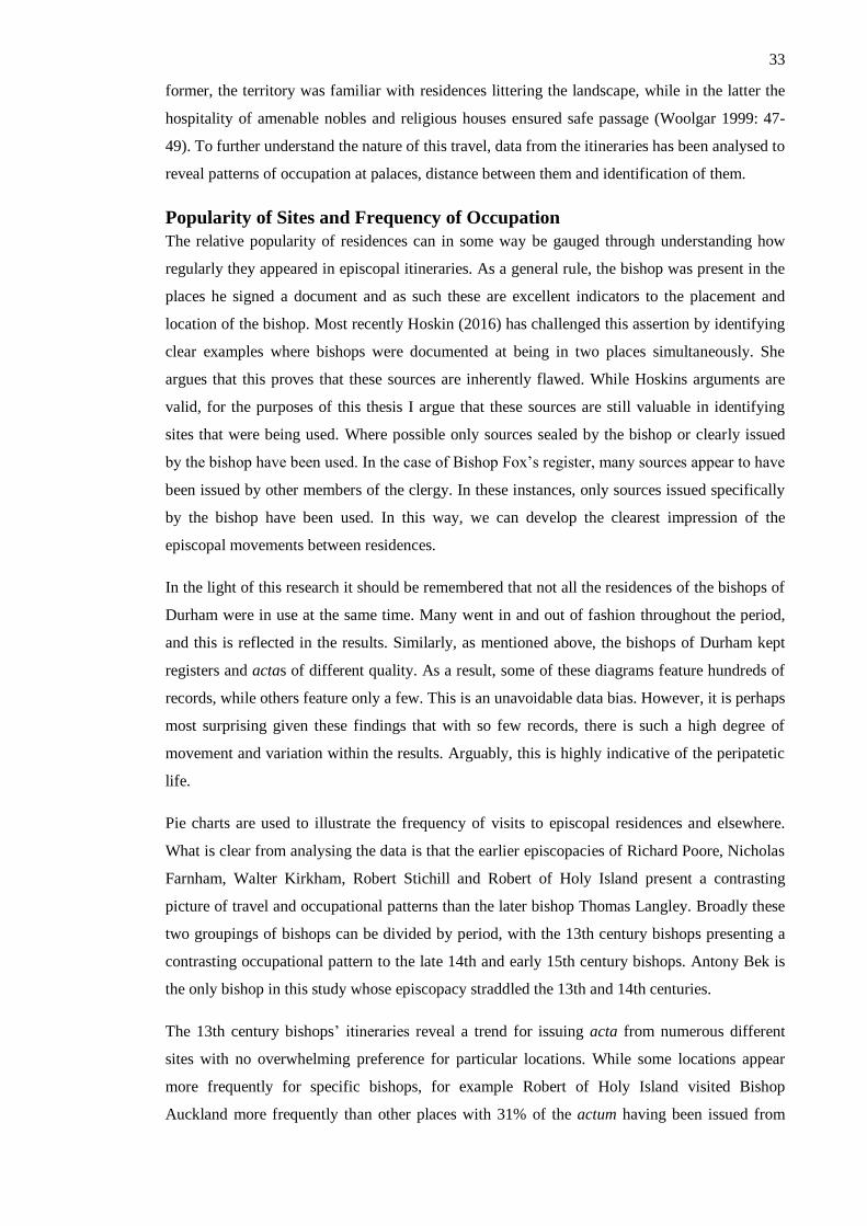
33
former, the territory was familiar with residences littering the landscape, while in the latter the
hospitality of amenable nobles and religious houses ensured safe passage (Woolgar 1999: 47-
49). To further understand the nature of this travel, data from the itineraries has been analysed to
reveal patterns of occupation at palaces, distance between them and identification of them.
Popularity of Sites and Frequency of Occupation
The relative popularity of residences can in some way be gauged through understanding how
regularly they appeared in episcopal itineraries. As a general rule, the bishop was present in the
places he signed a document and as such these are excellent indicators to the placement and
location of the bishop. Most recently Hoskin (2016) has challenged this assertion by identifying
clear examples where bishops were documented at being in two places simultaneously. She
argues that this proves that these sources are inherently flawed. While Hoskins arguments are
valid, for the purposes of this thesis I argue that these sources are still valuable in identifying
sites that were being used. Where possible only sources sealed by the bishop or clearly issued
by the bishop have been used. In the case of Bishop Fox’s register, many sources appear to have
been issued by other members of the clergy. In these instances, only sources issued specifically
by the bishop have been used. In this way, we can develop the clearest impression of the
episcopal movements between residences.
In the light of this research it should be remembered that not all the residences of the bishops of
Durham were in use at the same time. Many went in and out of fashion throughout the period,
and this is reflected in the results. Similarly, as mentioned above, the bishops of Durham kept
registers and actas of different quality. As a result, some of these diagrams feature hundreds of
records, while others feature only a few. This is an unavoidable data bias. However, it is perhaps
most surprising given these findings that with so few records, there is such a high degree of
movement and variation within the results. Arguably, this is highly indicative of the peripatetic
life.
Pie charts are used to illustrate the frequency of visits to episcopal residences and elsewhere.
What is clear from analysing the data is that the earlier episcopacies of Richard Poore, Nicholas
Farnham, Walter Kirkham, Robert Stichill and Robert of Holy Island present a contrasting
picture of travel and occupational patterns than the later bishop Thomas Langley. Broadly these
two groupings of bishops can be divided by period, with the 13th century bishops presenting a
contrasting occupational pattern to the late 14th and early 15th century bishops. Antony Bek is
the only bishop in this study whose episcopacy straddled the 13th and 14th centuries.
The 13th century bishops’ itineraries reveal a trend for issuing acta from numerous different
sites with no overwhelming preference for particular locations. While some locations appear
more frequently for specific bishops, for example Robert of Holy Island visited Bishop
Auckland more frequently than other places with 31% of the actum having been issued from

34
there; no location can be confidently asserted to have been a ‘favoured’ estate, with none issuing
over 50% of actum form a singular location. Instead numerous locations had actum issued from
them, suggesting that multiple locations were visited often. This is especially clear from the
itinerary of Robert Stichill who records having visited 7 locations within the bishopric of
Durham regularly, with none of these locations exceeding 23 per cent with five no less than 10
per cent of the time. It can therefore be suggested that these results indicate a highly
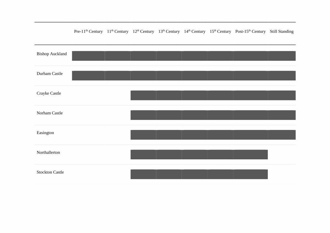
Pre-11th Century 11th Century 12th Century 13th Century 14th Century 15th Century Post-15th Century Still Standing
Bishop Auckland
Durham Castle
Crayke Castle
Norham Castle
Easington
Northallerton
Stockton Castle

36
Darlington
Bishop Middleham
Durham House
Wheel Hall
Howden Castle
Chapel Walls
Westgate Castle
Figure 2. Duration of use of these residences.

mobile episcopacy, visiting residences at an equal rate.
In contrast, the late 14th and 15th century itineraries reveal fewer sites where documents were
issued suggesting the adoption of a more sedentary lifestyle and the development of ‘favoured’
residence. In each of the pie charts relating to the itineraries of, Thomas Langley and, between
63 per cent and 76 per cent of acta issued came from a singular location. This is an evident
increase from the 39 per cent of acta issued from a singular location by Walter Kirkham in the
13th Century. Thomas Langley records from a broad spectrum of locations but the other two
(Skirlaw and Neville) record from three and four locations within the Durham bishopric
respectively. This suggests that bishops were travelling not only less, but to fewer locations.
However, this may instead result from a data collection bias insofar as we have fewer surviving
acta from these episcopacies. Nevertheless, from analysing Langley’s register it is clear that
there was a trend toward the establishment of ‘favoured’ estates.
The itinerary of Antony Bek from the late 12th/early 13th centuries reveals a bishop that moved
extensively around the bishopric, visiting numerous locations, with the early development of a
favoured estate in Bishop Auckland, issuing 46 per cent of actum from there. Although not as a
convincing as the more regularly visited ‘favoured’ palaces of Langley, Bishop Auckland is
visited more by Bek than other singular location from any earlier bishops. Arguably, what we
are seeing an emerging pattern for the development of ‘favoured’ estates beginning with Bek in
the late 12th and 13th centuries that, by the 15th century has developed further with bishops
spending the vast majority of their time in a singular location.
Elite Parallels
The evidence presented through the itineraries echoes a wider phenomenon repeated throughout
British nobility, both ecclesiastic and lay. Academic discussion of other English episcopal
itineraries has favoured the stance that bishops enjoyed an actively mobile life within their own
dioceses initially, with the development of ‘preferred’ estates from the late 14th/15th centuries
onwards (Woolgar 1999:46-47). Examples from across Britain substantiate this claim. After AD
1400 bishops from Salisbury regularly spent in excess of 200 consecutive days in a singular
location (Woolgar 1999:47). In addition, the Bishops of London regularly visited only 5 main
palaces, choosing not to inhabit a range of previously used domiciles (Woolgar 1999:47). This
trend was not confined to bishops and clergymen solely with royalty developing a similar trend
toward itinerancy. The most complete itineraries of Kings John (1199-1216), Edward I (1272-
1307), Edward II (1307-1327) and Edward III (1327-1377) exhibit a similar trend for the
development of sedentariness (Hindle 1976: 213-214). For example, Kings John and Edward I
accomplished 1,378 and 2, 891 moves respectively within their reigns, averaging 81 and 83
moves individually per annum (Hindle 1976: 213-214). In contrast, Edward II’s itinerary from
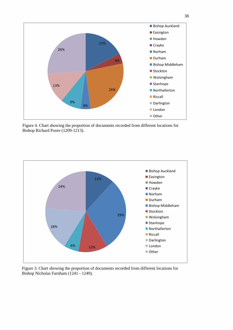
38
17%
4%
26%
4%9%
13%
26%
Bishop Auckland
Easington
Howden
Crayke
Norham
Durham
Bishop Middleham
Stockton
Wolsingham
Stanhope
Northallerton
Riccall
Darlington
London
Other
12%
29%
12%6%
18%
24%
Bishop Auckland
Easington
Howden
Crayke
Norham
Durham
Bishop Middleham
Stockton
Wolsingham
Stanhope
Northallerton
Riccall
Darlington
London
Other
Figure 4. Chart showing the proportion of documents recorded from different locations for
Bishop Richard Poore (1209-1213).
Figure 3. Chart showing the proportion of documents recorded from different locations for
Bishop Nicholas Farnham (1241 - 1249).
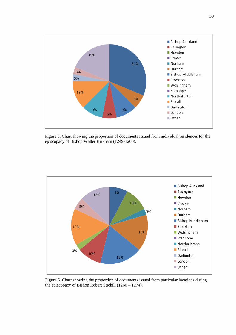
39
Figure 5. Chart showing the proportion of documents issued from individual residences for the
episcopacy of Bishop Walter Kirkham (1249-1260).
8%
10%
3%
15%
18%10%
3%
15%
5%
13%
Bishop Auckland
Easington
Howden
Crayke
Norham
Durham
Bishop Middleham
Stockton
Wolsingham
Stanhope
Northallerton
Riccall
Darlington
London
Other
Figure 6. Chart showing the proportion of documents issued from particular locations during
the episcopacy of Bishop Robert Stichill (1260 – 1274).
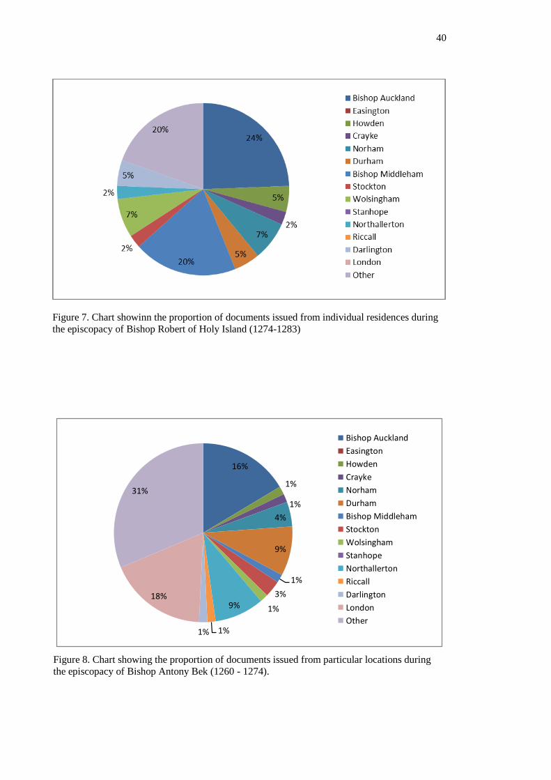
40
Figure 7. Chart showinn the proportion of documents issued from individual residences during
the episcopacy of Bishop Robert of Holy Island (1274-1283)
16%
1%
1%
4%
9%
1%
3%
1%9%
1%1%
18%
31%
Bishop Auckland
Easington
Howden
Crayke
Norham
Durham
Bishop Middleham
Stockton
Wolsingham
Stanhope
Northallerton
Riccall
Darlington
London
Other
Figure 8. Chart showing the proportion of documents issued from particular locations during
the episcopacy of Bishop Antony Bek (1260 - 1274).

41
Figure 9. Chart showing the proportion of documents issued from individual residences during
the episopacy of bishop Thomas Langley (1406 – 1437).
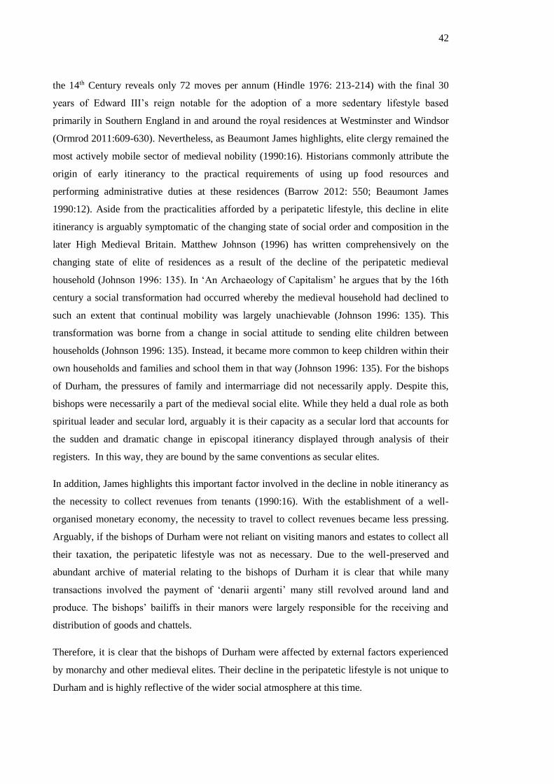
42
the 14th Century reveals only 72 moves per annum (Hindle 1976: 213-214) with the final 30
years of Edward III’s reign notable for the adoption of a more sedentary lifestyle based
primarily in Southern England in and around the royal residences at Westminster and Windsor
(Ormrod 2011:609-630). Nevertheless, as Beaumont James highlights, elite clergy remained the
most actively mobile sector of medieval nobility (1990:16). Historians commonly attribute the
origin of early itinerancy to the practical requirements of using up food resources and
performing administrative duties at these residences (Barrow 2012: 550; Beaumont James
1990:12). Aside from the practicalities afforded by a peripatetic lifestyle, this decline in elite
itinerancy is arguably symptomatic of the changing state of social order and composition in the
later High Medieval Britain. Matthew Johnson (1996) has written comprehensively on the
changing state of elite of residences as a result of the decline of the peripatetic medieval
household (Johnson 1996: 135). In ‘An Archaeology of Capitalism’ he argues that by the 16th
century a social transformation had occurred whereby the medieval household had declined to
such an extent that continual mobility was largely unachievable (Johnson 1996: 135). This
transformation was borne from a change in social attitude to sending elite children between
households (Johnson 1996: 135). Instead, it became more common to keep children within their
own households and families and school them in that way (Johnson 1996: 135). For the bishops
of Durham, the pressures of family and intermarriage did not necessarily apply. Despite this,
bishops were necessarily a part of the medieval social elite. While they held a dual role as both
spiritual leader and secular lord, arguably it is their capacity as a secular lord that accounts for
the sudden and dramatic change in episcopal itinerancy displayed through analysis of their
registers. In this way, they are bound by the same conventions as secular elites.
In addition, James highlights this important factor involved in the decline in noble itinerancy as
the necessity to collect revenues from tenants (1990:16). With the establishment of a well-
organised monetary economy, the necessity to travel to collect revenues became less pressing.
Arguably, if the bishops of Durham were not reliant on visiting manors and estates to collect all
their taxation, the peripatetic lifestyle was not as necessary. Due to the well-preserved and
abundant archive of material relating to the bishops of Durham it is clear that while many
transactions involved the payment of ‘denarii argenti’ many still revolved around land and
produce. The bishops’ bailiffs in their manors were largely responsible for the receiving and
distribution of goods and chattels.
Therefore, it is clear that the bishops of Durham were affected by external factors experienced
by monarchy and other medieval elites. Their decline in the peripatetic lifestyle is not unique to
Durham and is highly reflective of the wider social atmosphere at this time.

43
Extended Stays and Repeated Stays – What do they mean?
What this chapter has revealed so far is that the travel habits of the bishops of Durham reflected
a far greater atmosphere of change occurring in medieval elite groups as a result of political
revolution. Religious and political transformations resulted in the overall move away from
peripatetic episcopality and kingship across Britain by the 15th Century. The implications of this
are visible in the bishop’s palaces. Chapters Four and Five will tackle in more depth the material
remains of the buildings and the wider landscape to identify whether it is possible to
archaeologically identify any physical alterations made to accommodate this new lifestyle. From
the itineraries alone some features of sedentary episcopal life can be discerned.
For example, Thomas Langley (1406-1437) regularly spent the winter period at Auckland
Castle, Bishop Auckland. From his 31 year episcopacy, 16 lengthy wintertime stays at Bishop
Auckland have were recorded. While this may be a sign of his personal preference for this site,
as we see bishops favour different locations; arguably this could have been a result of the
amenities available at Bishop Auckland. The winter time periods he resided in Bishop Auckland
correspond strongly with known deer hunting seasons (Richardson 2005). This suggests an
attraction to the site that is directly unrelated to the spiritual and judicial roles of the bishop.
Hunting was an elite activity, popular as a communal sporting activity partaken by numerous
elites for the intention of strengthening social bonds and displaying wealth in a chivalrous
manner (Judkins 2013). In the case of Thomas Langley, the itineraries suggest that this was an
important aspect of his episcopacy to warrant annual two or three month winter habitation at
Auckland Castle. From this we can surmise that hunting was important either as a personal
endeavour of the bishop or as an important elite activity to strengthen interpersonal relationships
therefore embedding the bishop among the ranks of other medieval social elite and, as a result,
ensuring the perpetuity of the interests of the bishopric.
Another place highlighted as a frequently occupied site is the palace in London. Nearly all
bishoprics held an estate in London as a place to stay when conducting affairs there (Jenkinson
2009). From the itineraries it is clear that for some bishops this was a popular location,
suggesting other factors influencing the decision to occupy this site. One causative factor is the
personal political ambition of individual bishops. Antony Bek, for example, was a prominent
figure in the court of Edward II, assuming political roles, such as Investigator of the Templars,
in addition to being the Bishop of Durham (Fraser 1957). Thomas Langley, similarly held
political roles beign Lord Chancellor England to three kings and acting as the longest serving
medieval chancellor (Sharman 1999)
In some instances sites are listed within registers with little relation to known episcopal affairs.
One such example is the repeatedly visited site of Tarrant by Richard Poore (1209-1213). This
site probably relates to Tarrant Abbey and Cistercian Monastery in Dorset (Emery 2006: 596).
There is no known link between this religious institution and the bishopric of Durham.
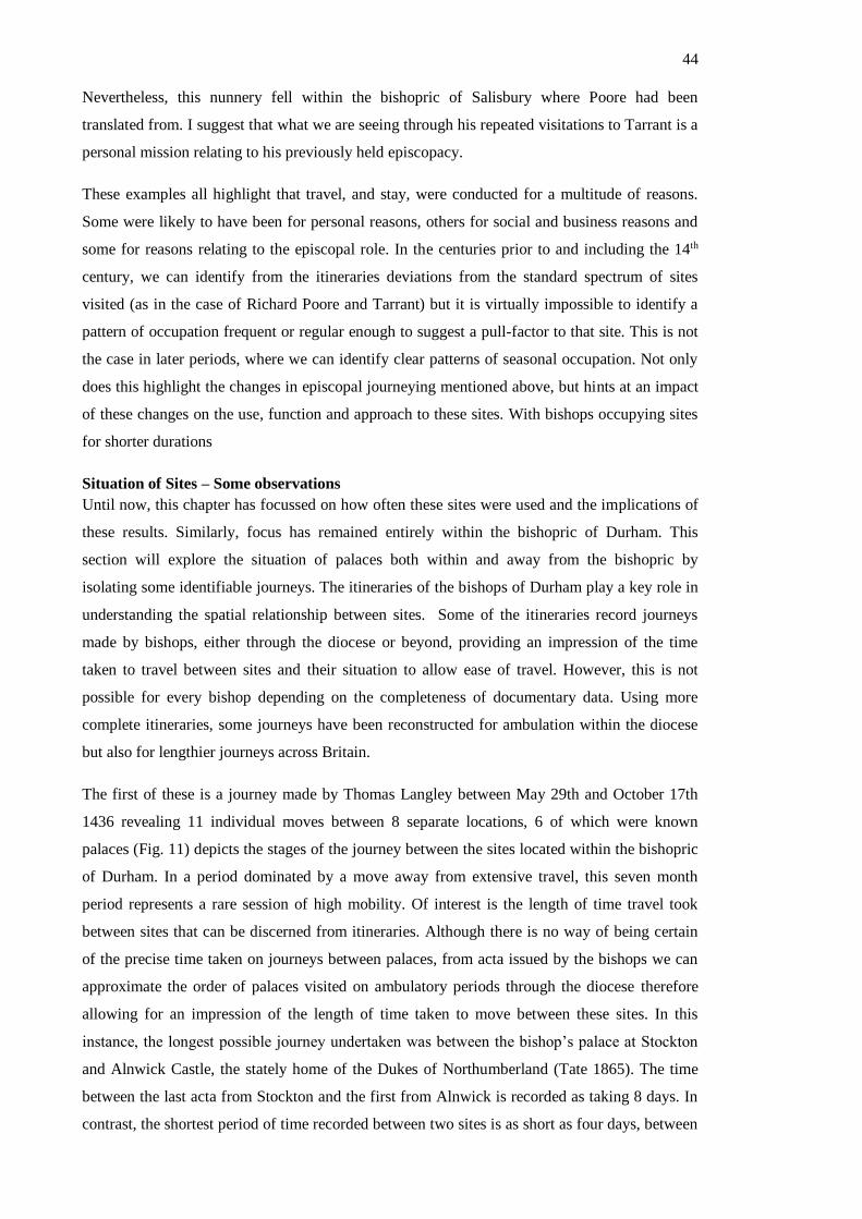
44
Nevertheless, this nunnery fell within the bishopric of Salisbury where Poore had been
translated from. I suggest that what we are seeing through his repeated visitations to Tarrant is a
personal mission relating to his previously held episcopacy.
These examples all highlight that travel, and stay, were conducted for a multitude of reasons.
Some were likely to have been for personal reasons, others for social and business reasons and
some for reasons relating to the episcopal role. In the centuries prior to and including the 14th
century, we can identify from the itineraries deviations from the standard spectrum of sites
visited (as in the case of Richard Poore and Tarrant) but it is virtually impossible to identify a
pattern of occupation frequent or regular enough to suggest a pull-factor to that site. This is not
the case in later periods, where we can identify clear patterns of seasonal occupation. Not only
does this highlight the changes in episcopal journeying mentioned above, but hints at an impact
of these changes on the use, function and approach to these sites. With bishops occupying sites
for shorter durations
Situation of Sites – Some observations
Until now, this chapter has focussed on how often these sites were used and the implications of
these results. Similarly, focus has remained entirely within the bishopric of Durham. This
section will explore the situation of palaces both within and away from the bishopric by
isolating some identifiable journeys. The itineraries of the bishops of Durham play a key role in
understanding the spatial relationship between sites. Some of the itineraries record journeys
made by bishops, either through the diocese or beyond, providing an impression of the time
taken to travel between sites and their situation to allow ease of travel. However, this is not
possible for every bishop depending on the completeness of documentary data. Using more
complete itineraries, some journeys have been reconstructed for ambulation within the diocese
but also for lengthier journeys across Britain.
The first of these is a journey made by Thomas Langley between May 29th and October 17th
1436 revealing 11 individual moves between 8 separate locations, 6 of which were known
palaces (Fig. 11) depicts the stages of the journey between the sites located within the bishopric
of Durham. In a period dominated by a move away from extensive travel, this seven month
period represents a rare session of high mobility. Of interest is the length of time travel took
between sites that can be discerned from itineraries. Although there is no way of being certain
of the precise time taken on journeys between palaces, from acta issued by the bishops we can
approximate the order of palaces visited on ambulatory periods through the diocese therefore
allowing for an impression of the length of time taken to move between these sites. In this
instance, the longest possible journey undertaken was between the bishop’s palace at Stockton
and Alnwick Castle, the stately home of the Dukes of Northumberland (Tate 1865). The time
between the last acta from Stockton and the first from Alnwick is recorded as taking 8 days. In
contrast, the shortest period of time recorded between two sites is as short as four days, between

45
Alnwick and Durham and Bishop Auckland and Stockton. Taken together, it is clear that the
journeys between palaces and other stately homes within the bishopric could be rapid. Aside
from ‘Heywod’, an unknown location from which acta were recorded on September 12th,
movement appears to be restricted to only episcopal palaces and elite residences, with any way-
stations or overnight stopover locations not recorded. Therefore, the impression from this
evidence is that travel between palaces and elite residences could be done swiftly, with most
primary palaces (such as those at Bishop Auckland, Durham, Darlington and Stockton) no more
than a four day journey apart. Even locations at the peripheries of the bishopric required longer
journeys (of no more than 8 days journey from the nearest primary palace) but these were
limited due to the close proximity of palace sites that were scattered through the diocese. Even
Alnwick, the furthermost locations, was no more than four days from Durham. For example, no
journey was undertaken across the whole diocese, with intermittent locations instead occupied.
This indicates an appreciation of the necessity to place sites accordingly so as to limit extensive
travel between sites and facilitate a peripatetic lifestyle.
Contrastingly, on journeys beyond the bishopric, episcopal palaces of Durham were sparse, with
travel instead conducted through a likely series of way-stations and other elite residences
(Barrow 2012). The most common place visited outside of the bishopric is London. For bishops
of Durham, answerable only to the King and Pope, London represented a place of significant
importance as a focus for monarchic rule and a communal centre for bishops and secular elites
nationwide (Williams 2007).The bishops of Durham, like other bishops, held a residence in
London used for lengthy stays in the capital city.

46
Figure 10. An example of Thomas Langley's itineration during 1436.
Thomas Langley
1436
May 29th Bishop
Auckland
June 5th Darlington
9th Crayke

47
25th Bishop
Auckland
27th Bishop
Auckland
August 1st Stockton
7th Stockton
8th Stockton
12th Stockton
20th Alnwick
24th Durham
September 10th Stockton
12th Heywod?
14th Stockton
23rd Stockton
October 4th Stockton
16th Bishop
Auckland
Table 1 An excerpt of the itinerary of Thomas Langley in 1436.
No recorded residences exist on the stretch of land between the historic county of Durham and
London. Logically, therefore, when conducting journeys between these places, way-stations
and other elite residences were used as overnight shelters and as places to acquire food and
warmth (Barrow 2012). Documentary sources from other bishoprics indicate this practice, with
precise routes constructed using this geographic information (Barrow 2012). In the case of the
bishops of Durham, using itineraries alone, few connecting locations can be identified. Often
the only trace of this journey is a conspicuous gap in recorded locations. This is especially
apparent with earlier bishops, with some later bishops recording occasional intercessional
locations
Figure 12 shows the journey made by Langley between 1414 and 1415. With the start and end
places recorded as Bishop Auckland, Langley embarked on a journey southwards to London
stopping for an estimated 3 weeks in Leicester followed by a journey onwards to the ‘manerio
nostro’ in London (‘our manor in London’) taking no longer than 15 days. Leicester presents a
logical stopping place as a sizeable and well situated medieval town featuring the palace of the

48
Bishops of Lincoln (Thompson 1998:179). This route conducted by Langley hint at what can be
expected to be a typical travel pattern, revealing lengthy stops at places of episcopal activity
with periods of rapid travel across the landscape between these sites.
We see this pattern replicated with stops instead reported at Grantham (Lincolnshire),
Swineshead (Lincolnshire), Selby (‘capella sancti Germani de Selby juxta ripam fluvii de Ouse
Eboracensis’ – The Chapel of St Germain of Selby beside the river Ouse of York). Each of
these examples is ideally located on the route toward London, making them desired stopover
locations. Moreover, these sites share similar features. Grantham has a long history of royal and
episcopal ownership with all castles and manors in Grantham granted to the 1st Duke of York in
1363 (Start and Stocker 2011). Similarly, nearby Swineshead is the site of a medieval moated
manor, Swinehead Abbey and a substantial 12th Century motte castle with visible earthworks
(Page 1906). Continuing the theme, Selby, as recorded in the register, features the chapel of St.
Germain with accompanying abbey (Farrar and Abbey 1979). All these sites, in accordance with
Leicester discussed above, are prominent elite and/or religious centres. Therefore, the pattern of
travel across country is a journey spanning approximately 15 days (suggested from the
itineraries) intersected by a visitation to a prominent elite residence part-way through the jurney.
Any other residences used en route, which presumably happened as it did elsewhere (Barrow
2012; Woolgar 1999) are not recorded in actas representing a symptom of the inherent data
bias accompanying the use of episcopal registers.
Figure 11. Map showing Langley's
journey from Bishop Auckland to
London via Leicester in 1414.
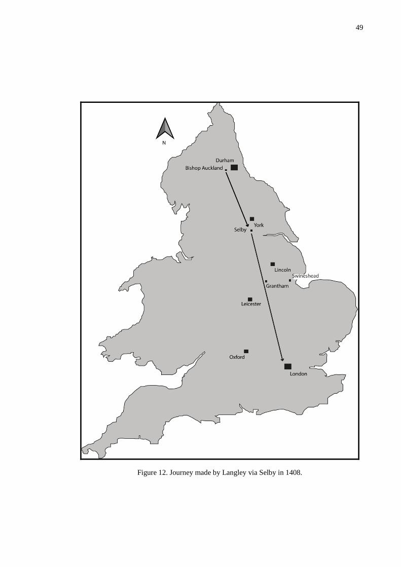
49
Figure 12. Journey made by Langley via Selby in 1408.

50
Figure 14. Journey made by Langley via Grantham in 1409
.
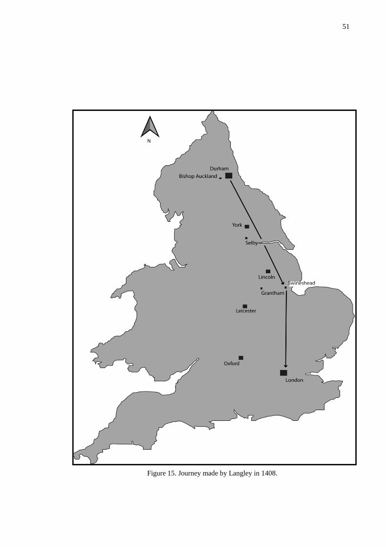
51
Figure 15. Journey made by Langley in 1408.

52
Lastly, the focal point of the journeys discussed reveals a further aspect of episcopal itinerancy.
From reading the itineraries it is clear that Durham House, the bishop’s palace in London,
served as a satellite point for activity in the city. A wide range of locations in and near London
were visited by bishops from every period including: Westminster, Fulham (residence of the
Bishops of London with adjoining park), Charing Cross, Waltham (described as being near
London – probably Waltham Abbey, Essex), Aldenham (historic settlement near Watford,
North London), Oldford, Suthwik/Southwark, Tottenham, Duresmesyn (described as being
close to Charing Cross), Eltham (probably Eltham Palace, south of the Thames) and Istelworth
(probably Isleworth, London) despite Durham House not being built until 1345 (Schofield
2003). All these locations are now considered either within the City of London or existing in
present day suburbs. Durham House is situated on the modern day Strand, beneath the Adelphi
Theatre (Schofield 2003) on the banks of the Thames. This central location therefore enabled
travel to city-centre residences, such as those of Charing Cross, Westminster , Eltham Palace
and Fulham in addition to travel further afield to the likes of Aldenham and Waltham Abbey.
No long stays at these sites have been recorded, which may be a symptom of a data bias but
equally may suggest that these sites were visited for daily durations. The impression this gives
therefore is that Durham House, recorded more regularly than any other location, remains a
permanent dwelling from which other sites were visited. This mimics the function of the royal
palaces of Westminster, suggesting that the pattern of increased sedentariness visible within the
bishopric of Durham extends to the bishops London lives.
Discussion
Using itineraries, the movements of the bishops have been analysed in both local and national
settings across the broad high medieval period. The results show three important things. Firstly,
that the nature of intradiocesenal travel varied from a state of high mobility to one of
predominant sedentariness by the end of the High Medieval Period, with a combination of
social, political and religious factors plausibly accountable for this. Secondly, that movement
across Britain can be identified in itineraries as featuring a universal characteristic for bisecting
the journey with a lengthy stay at an elite residence or religious house mid-way from County
Durham to London. Lastly, the situation of Durham House in London allowed for the easy and
convenient visitation to sites of interest from its central location. These observations drawn
from itineraries presents a very clear impression of precisely how these habitations were used
both in geographic and chronological frames.
On the one hand, we see the use of residences vary hugely over time. As discussed above, the
beginning of the High Medieval Period is characterised by high mobility that ceases by the
14th/15th centuries favouring the adoption of ‘preferred estates’ (Woolgar 1999). This is a pattern
we see repeated across England with the turbulent political and social backdrop of the early

53
High Medieval Period a possible cause. This is especially clear in County Durham, where
aggressive political measures were enacted to ensure compliance to the new Norman rule. It has
been argued that episcopal itinerancy was both a symptom of these times but equally an active
measure in ensuring stability in the face of much upheaval. The increased visibility of the
bishop by both the public and other elites allowed for control to be strictly enforced.
Nevertheless, by the 14th and more noticeably within the 15th century, the adoption of
‘preferred’ estates is noticeable, arguably resulting from the increase in episcopal powers during
the formation of the ‘County Palatine’ in 1293 (Fraser 1957). This moment bestowed upon the
bishop a greater degree of autonomy within the bishopric in exchange for fortifying Durham
against invading Scots. In turn, we see a pattern of travel emerge fitting more closely to that of
many contemporary monarchs. In accordance with greater monarchical stability following the
signing of the Magna Carta, many kings ceased active travel. Arguably, the bishops, who by the
14th century wielded great power and influence in royal spheres (Schofield 1999), adopted a
lifestyle akin to that.
The implications of this lifestyle meant that people had to travel to see the bishop. This meant
that palaces for regular habitation could be chosen on the basis of useful amenities for this
emerging lifestyle rather than for purely geographic convenience. Although we see palaces
within the diocese positioned conveniently to limit lengthy travels between sites, suggesting
awareness for a peripatetic episcopacy in their placement within the landscape, the timing of
recorded visits allow us a more precise idea of attraction to individual locations. For example,
regular winter habitation at Bishop Auckland matches conveniently with deer hunting seasons
(Richardson 2005), indicating that hunting may have been a pull-factor at that site.
While the use of residences change over time in County Durham reflecting a change in the
episcopal role, the bishops of Durham were concerned with different pursuits when in London.
Instead of managing the bishopric both spiritually and judicially, in London business was more
concerned with national and international politics and affairs with the bishops sometimes
embroiled in affairs relating to their own political ambitions (Sharman 1999). Evidence from the
itineraries indicates that Durham House, was used as a primary residence when in London and
that visitations to London increased in the later periods. Arguably, this pattern of use is more
reminiscent of a secular monarch, echoing the way Westminster was used as a primary London
residence of medieval kings (Sharman 1999).
Conclusion
Therefore, the itineraries present a contrasting image of episcopacy with their use of residences
serving as an indicator for these. As social attitudes to elite life changed, their residences were
similarly used differently with the emergence of permanent residences emerged This mimicked
transformations elsewhere, most notably among monarchy from the same period. Using
54
itineraries alone it is possible to reconstruct the way that these palaces were used over the
medieval period. This is an unachievable feat using traditional archaeological methods alone.
The rest of this thesis will focus on the archaeological evidence for the buildings and landscapes
of the bishop’s palaces to further inform traditional narratives of how they were used, how they
changed over time to accommodate changing requirements and how they influenced and were
influenced by the landscape in which they inhabited. These are all themes touched upon in this
chapter which can be further examined using archaeological datasets.

55
Chapter Four
The Residences: A study in form, function and
meaning
For medieval bishops, their residence represented more than a home. They offered a combined
set of uses that reflected the multiplicitous duties entailed with episcopacy. From being arenas
for both stately affairs and religious jurisdiction to providing a domestic dwelling, the buildings
had to accommodate a wide range of different, and sometimes opposed requirements. Chapter
Three revealed how the situation of residences facilitated the lives of the bishops by allowing
them to move with ease through the landscape resulting in the irregular and intermittent use of
particular sites based on the continually evolving role of the bishops. Their relative placement
within the landscape reflected their function at different chronological periods and building
upon this evidence, the function of these buildings will be explored to reveal the form they took,
and how this changed alongside the role of the bishops.
Miller expresses the ‘fundamental relationship’ (2000:13) between form and function of a
building as inextricably linked. While function refers to the utility of the space, form is the
manifestation of this architecturally. Miller argues that function undeniably advises the form,
and that in turn the form conveys and inspires meaning (Miller 2000). The principles of access
analysis adhere to a similar concept. Hillier and Hanson (1984) were among the first to attempt
to understand created space through the interconnected dimensions of function, style and the
social meaning. They argue, effectively, that social meaning can be interpreted from the relative
permeability of different spaces. Gilchrist (1999), Richardson (2003) and Johnson (2002) have
all analysed access routes through medieval buildings to better understand the social factors that
affected and motivated those who created these spaces, and those who used them. A recurring
theme through these studies is the continually evolving nature of these buildings. It is through
the identification and study of the changing aspects that provide a comparative point of
examination with which to understand the social and functional factors involved. These changes
through which meaning can be inferred has been termed ‘transformational grammar’: a concept
that notionally accepts buildings and artefacts as transmitting the thoughts of the builders and
architects as a decipherable ‘language’. This chapter will attempt to decipher this ‘language’
(Richardson 2003).
56
Part One provides an in-depth review of available archaeological and historical evidence that
relates to the physical remains of the residences of the bishops of Durham. This includes a
consideration of both standing and below-ground remains that relate to an understanding of the
form, layout and structure of these buildings. From this, the chronological phasing and building
plans have been composed in examples where the evidence permits this. The residences have
been categorised according to the nature and quality of their standing remains. Part Two
analyses this data using the philosophical principles of access analysis. Through this approach,
the social meaning and contexts of the buildings have been suggested in relation to how they
reflect and challenge our understanding of the changing role of the bishops.
Sites with substantial standing remains
Auckland Castle
Until recent years, Auckland Castle was the principal residence of the bishops of Durham in the
post-medieval period (Howse 2011). Due to its continued ecclesiastical role, Auckland Castle
has been well preserved as a rare example of an active bishop’s palace. Most recently, Auckland
Castle has been a popular heritage visitor attraction. Current plans are in place to develop this
aspect of Auckland Castle with a significant extension attached to the ‘Scotland Wing’6. As a
result, there has been an extensive archaeological investigation of this site that incorporates data
from excavations, geophysical prospection and standing building analysis (ASUD 2013, ASUD
2014 a and b). This builds on a strong legacy of textual and archaeological investigation at
Auckland Castle, beginning with Raine in 1852 that helps to uncover the design of Auckland
Castle through its development.
Phase 1 – pre-13th century
There are some clear indicators to suggest that there had been a residence at the site of
Auckland Castle prior to the Boldon Book (1183) having been written. Descriptors in it suggest
that this manor, and an episcopal residence within it, were already established. For example,
‘the hall of the Bishop in the forest’ is described as having posts 16 ft apart and comprising a
complex featuring a chapel ‘40 feet in length’ as well as a chamber and a privy (Austin 1982:
37). Gill et al (1976) have highlighted the term ‘weardsetle’ might be indicative of this earlier
phase of occupation. As the earliest fabric at Auckland Castle dates from Puiset’s episcopacy
(1154 - 1198) (Cunningham 1980), it is likely that any buildings before this date were probably
constructed of timber that has not survived through the later stone phases of Auckland Castle.
6 Current plans are in place by the Auckland Castle Trust and are described in detail at
http://aucklandcastle.org/community/plans.

57
St Peter’s Chapel, formally le Puiset’s hall, is the only part of Auckland Castle to retain 12th
century fabric. The north wall of this space incorporates in situ ashlar masonry, while internally
some high-quality 12th century decorative moulding is present (Ryder 2005). Notably, there are
four bay arcades in a cruciform arrangement displaying Romanesque waterleaf embellishment
on some piers (Ryder 2005). In addition, the embellishment on some of the piers is of typical
12th Century design (Ryder 2005) and of unusually high-quality craftsmanship while in
comparison the north and south shafts are constructed from Frosterley marble, parallels of
which exist at Durham Cathedral (Blair 1991: 49). Ryder highlights that the highest-quality
stonework is focused at the western end of the space, hinting at its earlier function as a 12th
century hall (Ryder 2005). This interpretation therefore places the head table at the western end.
Drury (2012) has suggested a possible building phasing based on standard medieval vernacular
design. These assertions are informed by contemporary documentary sources that record the
underpinning of the parlour walls and ‘my lords chamber’ in 1387-8 (cited in Drury 2012). This
extract locates these rooms ‘north of the small garden’, thus also placing them west of the hall
and corroborating Ryder’s interpretation of the arrangement of high-quality stonework in St.
Peter’s Chapel.
In addition, excavation beneath the current floor surface (a raised floor laid by Bishop Cosin) of
St. Peter’s Chapel provides insight into the development of the hall. Two trial trenches
excavated within the hall as a response to damp uncovered a possible early floor surface
(mentioned in ASUD 2014b). Beneath Cosin’s floor, a relaid earlier stone floor was uncovered
atop of a beaten earth surface with distinct areas of burning visible, consistent with a hearth,
though the lack of available datable remains means this cannot be firmly dated to the early 12th
century occupational phases. However, the floor surface and position of the possible ‘hearth’
corroborates the spatial understanding of the hall realised from others sources.
Phase Two (13th - 14th Centuries)
The second structural phase falls mainly within the bishopric of Antony Bek (1284-1311). It
was at this time that Auckland Castle took on its characteristic L-Shaped configuration, through
Bek’s construction of a second accommodation range. Receipts from 1307-1308 record Bek’s
construction of a chamber, undercroft and chapel (cited in Drury 2012), Bek’s first floor
chamber now forms the modern ‘Throne Room’. This space features an original wooden floor
throughout, and the original arrangement of rooms is thought to have altered little (ASUD 2014
(b)). Adjacent to the ‘Throne Room’ on the northern extent is a small antechamber that served
as a holding space for visitors.
Adjacent to the Bek’s Chamber on the southern extent was a chapel, known only through
documentary sources and an image from c.1680 (see Fig 20). Given its location in the image, it
appears to have only been accessed through Bek’s Chamber, it is probable that this was a
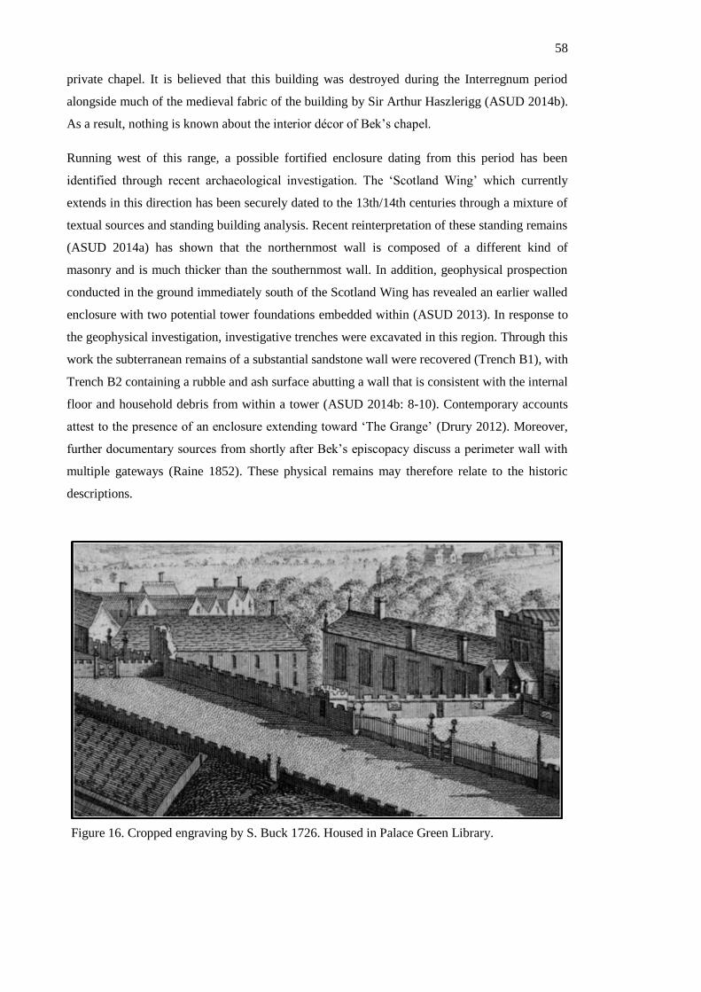
58
private chapel. It is believed that this building was destroyed during the Interregnum period
alongside much of the medieval fabric of the building by Sir Arthur Haszlerigg (ASUD 2014b).
As a result, nothing is known about the interior décor of Bek’s chapel.
Running west of this range, a possible fortified enclosure dating from this period has been
identified through recent archaeological investigation. The ‘Scotland Wing’ which currently
extends in this direction has been securely dated to the 13th/14th centuries through a mixture of
textual sources and standing building analysis. Recent reinterpretation of these standing remains
(ASUD 2014a) has shown that the northernmost wall is composed of a different kind of
masonry and is much thicker than the southernmost wall. In addition, geophysical prospection
conducted in the ground immediately south of the Scotland Wing has revealed an earlier walled
enclosure with two potential tower foundations embedded within (ASUD 2013). In response to
the geophysical investigation, investigative trenches were excavated in this region. Through this
work the subterranean remains of a substantial sandstone wall were recovered (Trench B1), with
Trench B2 containing a rubble and ash surface abutting a wall that is consistent with the internal
floor and household debris from within a tower (ASUD 2014b: 8-10). Contemporary accounts
attest to the presence of an enclosure extending toward ‘The Grange’ (Drury 2012). Moreover,
further documentary sources from shortly after Bek’s episcopacy discuss a perimeter wall with
multiple gateways (Raine 1852). These physical remains may therefore relate to the historic
descriptions.
Figure 16. Cropped engraving by S. Buck 1726. Housed in Palace Green Library.

59
Phase Three (1311 – 1550)
Following Bek’s building achievements, a sequence of other later medieval bishops
commissioned additions to Auckland Castle. Among these was the creation of a curtain wall
encircling the complex. The account rolls for Bishop de Bury (1338) record structural work to
this as well as spaces built by Bek (Ryder 2005/6). Embedded within this curtain wall, a
gateway was created by Bishop Skirlaw (1388 – 1406) (Ryder 2005/6). This building has since
been entirely replaced by a later gateway under Bishop Booth (1476-1480) and then again by
Bishop Trevor in 1760 (Colvin 1978: 703). The resulting building does not contain any original
medieval fabric but is thought to follow the footprint of the earlier buildings (Ryder 2005/6).
North of this building, a further tower set into the wall and backing onto Silver Street has been
dated to the 15th century (Ryder and Degnan 1998). Adjacent to this tower appears to be an old,
and now unused, entrance to the complex. The walls extending from this are probably
contemporary with the tower due to consistencies in the nature of their fabric. Due to the
proximity of the tower and the entrance, it is highly probable that the tower was built to serve as
a gatehouse. It is unlikely however, that this was ever the primary entrance into the complex, as
it would have resulted in a complicated and impractical route for carriages and horses to
navigate to reach the entrance (Ryder and Degnan 1998). Raine (1852) proposed that this was
the entrance to the College. This interpretation implies that the College remained detached from
Auckland Castle in some respects.
Figure 17. Image dating from c. 1680. Currently dislayed in Auckland Castle. Bishop
Bek’s Chapel occupies the immediate foreground against the backdrop of Bek’s
Chamber and accommodation wing.
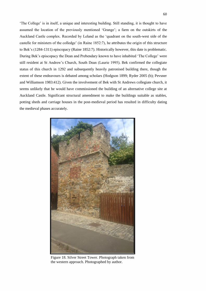
60
‘The College’ is in itself, a unique and interesting building. Still standing, it is thought to have
assumed the location of the previously mentioned ‘Grange’; a farm on the outskirts of the
Auckland Castle complex. Recorded by Leland as the ‘quadrant on the south-west side of the
castelle for ministers of the colledge’ (in Raine 1852:7), he attributes the origin of this structure
to Bek’s (1284-1311) episcopacy (Raine 1852:7). Historically however, this date is problematic.
During Bek’s episcopacy the Dean and Prebendary known to have inhabited ‘The College’ were
still resident at St Andrew’s Church, South Dean (Laurie 1995). Bek confirmed the collegiate
status of this church in 1292 and subsequently heavily patronised building there, though the
extent of these endeavours is debated among scholars (Hodgson 1899; Ryder 2005 (b); Pevsner
and Williamson 1983:412). Given the involvement of Bek with St Andrews collegiate church, it
seems unlikely that he would have commissioned the building of an alternative college site at
Auckland Castle. Significant structural amendment to make the buildings suitable as stables,
potting sheds and carriage houses in the post-medieval period has resulted in difficulty dating
the medieval phases accurately.
Figure 18. Silver Street Tower. Photograph taken from
the western approach. Photographed by author.
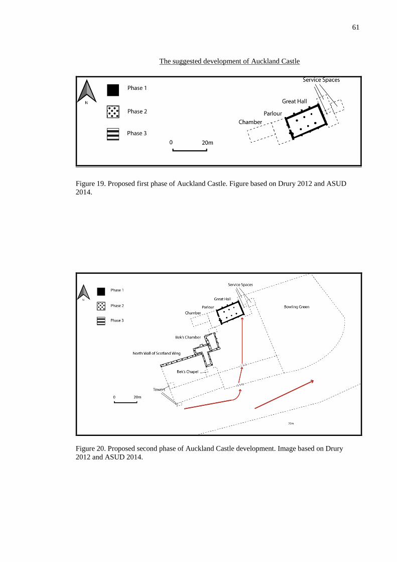
61
The suggested development of Auckland Castle
Figure 19. Proposed first phase of Auckland Castle. Figure based on Drury 2012 and ASUD
2014.
Figure 20. Proposed second phase of Auckland Castle development. Image based on Drury
2012 and ASUD 2014.

62
Figure 21. Phase Three Auckland Castle development. Image based on Drury 2012 and ASUD
2014
Seaton Holme – Easington, Co. Durham
Built as a residence for the bishops of Durham and used latterly as a base for the archidiaconate
of Durham, the site of Seaton Holme comprises three ranges, the Main Range, ‘Oratory’ and
North Range (Surtees 1816). In the Main Range and ‘oratory’, a vast majority of the original
medieval fabric is thought to have survived alongside more recent alterations (Ryder 1960).
Conversely, the North Range has been demolished and as a result any impression of it has been
drawn from archaeological investigation. Additionally, much of the historical documentation
has been lost following its sale in 1921 (ASUD 2000). Therefore, the archaeological record has
proved a vital resource in understanding the complicated evolution of this building. Unlike other
residences of the bishops of Durham however, Seaton Holme adopted a dual role as the seat of
the archdiaconate of Durham from 1378 (Dickens 1774). It is unclear to what extent this has
influenced the form, shape and style of the residence.
Phase 1 (13th - 14th Century)
The residence at Seaton Holme is universally recorded in antiquarian literature as having been
built for Bishop Farnham’s retirement in 1248 (Ryder 1960). Despite this, evidence from
itineraries suggests that bishops had been frequenting Easington earlier than this date, with
documents issued from this place as early as 1236. This could indicate that the bishops had been
visiting Easington without possessing a formal residence there, or that the assumed 1248 date is
unreliable.
Due to later medieval renovation of the site, substantial quantities of original fabric has been
lost. Despite this, an impression of the arrangement of rooms from this period can be understood
63
though careful analysis of the architecture. For example, although the current hall is of
predominantly 15th century date (Emery 1996), windows and wall scars in the interior of the
building allude to an earlier and smaller hall having sat at the site. Emery has suggested that
initially an aisled hall existed that was enlarged in the 15th century, to create a wider, unaisled
space. This would explain the lack of 12th century fabric within the interior of the building and
also explain the building scars and remnants of earlier architectural detailing.
The east-wing, entered through a series of three arches from within the hall, has been dated to
the mid-13th century also (Emery 1996:87). Both architectural assessments (ASUD 1998; Emery
1996:87) and dendrochronological dates taken from roof timbers (Arnold 2008) support this
assessment. These spaces are consistent with our understanding of service spaces that normally
lay adjacent to the hall in standard medieval manor house construction.
Dated to this same period are aspects of the ‘oratory’ or north range. Through standing building
analysis conducted before its conversion into office space in the late 1990s, a complex building
sequence was uncovered. The northern end appeared to be more consistent with 15th century
construction whereas the southern end featured aspects of 13th century fabric (ASUD 1998). It is
likely, therefore, that this building reveals aspects of two distinct building phases. Also
identified through the standing building elevations is clear evidence of blocked doorways and
elements of ornamental, high-status stonework (ASUD 1998). This contrasts with evidence
from excavations within the building that revealed no floor surface consistent with its use as
hall. Instead, the lack of any distinct surface is more indicative of its use as a barn or agricultural
building. This aligns with a description of a ‘tithe barn’ associated with the manor (ASUD
1998). Alternatively, it has been suggested (ASUD 1998) that the building had a second-storey
entrance that might have reflected its use as a potential accommodation range.
Historic maps depict two further building close to Seaton Holme manor site, immediately west
of the ‘Oratory’. Although these have since been demolished, testimony from a local farmer
suggests these buildings had similar architectural detailing to that from the Seaton Holme site
(ASUD 1998). It is therefore highly likely that these were associated with the bishop’s residence
and might have played an important role within the complex. Excavation of the corner of one
these buildings did not produce any dateable evidence however, from the descriptions from the
farmer it seems likely these could have been 13th century in date (ASUD 1998). Because of the
unreliability of this evidence, these buildings have not been included in reconstructions of the
site.
Moreover, historic maps also allude to an eastern range extending between the ‘Oratory’ and
Main Range. Today, only part of the northernmost wall stands. Although no clearly identifiable
architectural features are present, archaeologists from the 1998 excavation of the north wall
highlighted the similarity in construction style between this wall and the earliest 13th century

64
phases of the ‘oratory’ (ASUD 1998). Based on this, it seems plausible that this building is part
of the earliest building at the site and represents a third range. Through the inclusion of this
building, the earliest 13th century building appears to have been arranged in a horseshoe-shaped
complex around a central courtyard with the southern extent unenclosed. However, it should not
be assumed that there has never been a fourth range at the site, as this possibility has not been
investigated archaeologically.
Phase Two (15th Century)
The second major structural phase is predominantly confined to the 15th century. As mentioned
previously, the enlargement of the hall in the Main Range is the most characteristic building
addition from this period. Emery (1996: 87) has highlighted that scarring on the northern
exterior wall of the hall might allude to the presence of a porch that now no longer stands.
Emery (1996: 87) further suggests that there might have been an identical porch in a mirrored
position on the other side of the hall, although there is no archaeological evidence to corroborate
this.
The west-wing of the Main Range appears contemporary with the enlargement of the hall in 15th
century. Although the exterior facade has been obscured by 19th century gothick design, this
space has been stylistically dated to the 15th century from internal design elements (Ryder
Figure 22. 1864 OS map of Easington. Buildings circled in red are the two demolished
associated structures while the buildings comprising the Seaton Holme accommodation
complex are highlighted in blue.
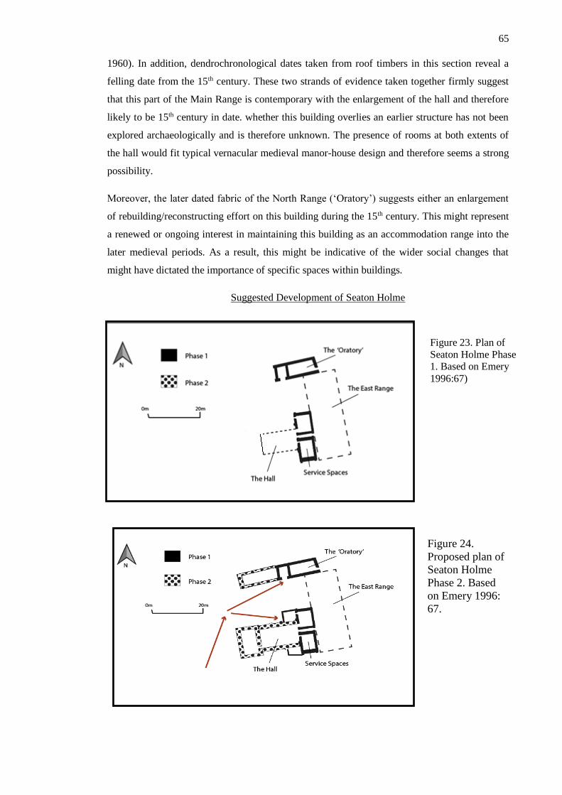
65
1960). In addition, dendrochronological dates taken from roof timbers in this section reveal a
felling date from the 15th century. These two strands of evidence taken together firmly suggest
that this part of the Main Range is contemporary with the enlargement of the hall and therefore
likely to be 15th century in date. whether this building overlies an earlier structure has not been
explored archaeologically and is therefore unknown. The presence of rooms at both extents of
the hall would fit typical vernacular medieval manor-house design and therefore seems a strong
possibility.
Moreover, the later dated fabric of the North Range (‘Oratory’) suggests either an enlargement
of rebuilding/reconstructing effort on this building during the 15th century. This might represent
a renewed or ongoing interest in maintaining this building as an accommodation range into the
later medieval periods. As a result, this might be indicative of the wider social changes that
might have dictated the importance of specific spaces within buildings.
Suggested Development of Seaton Holme
Figure 23. Plan of
Seaton Holme Phase
1. Based on Emery
1996:67)
Figure 24.
Proposed plan of
Seaton Holme
Phase 2. Based
on Emery 1996:
67.
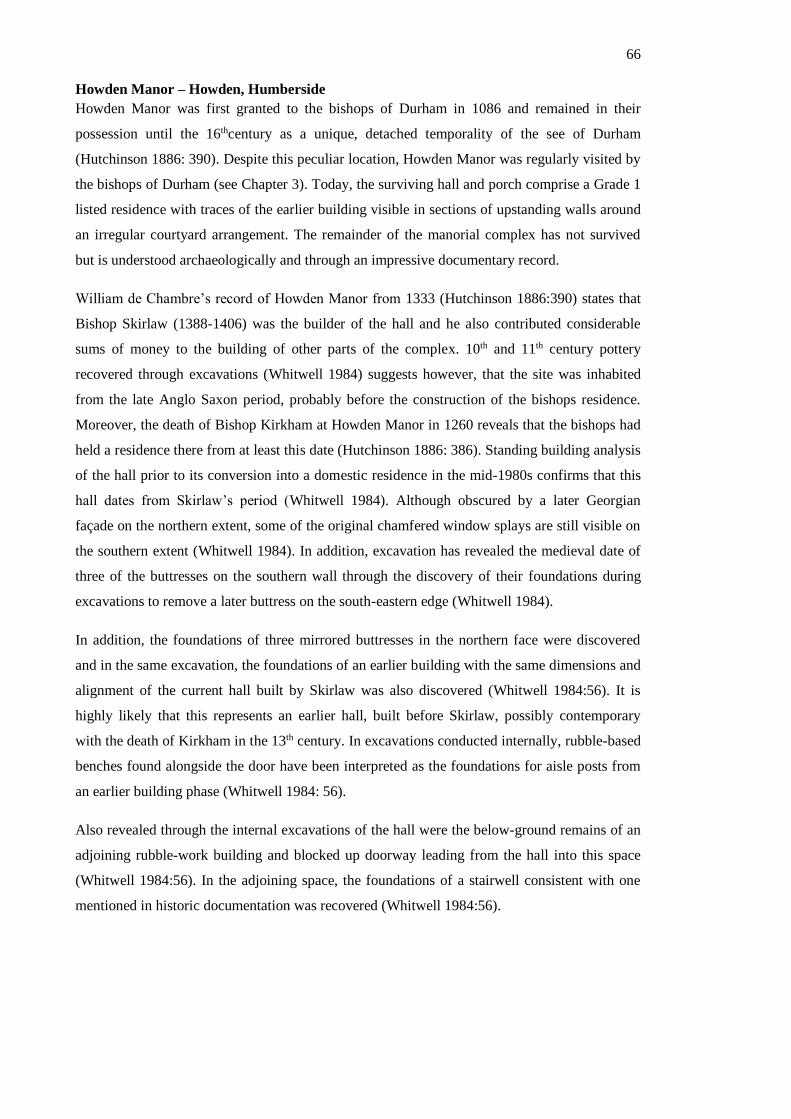
66
Howden Manor – Howden, Humberside
Howden Manor was first granted to the bishops of Durham in 1086 and remained in their
possession until the 16thcentury as a unique, detached temporality of the see of Durham
(Hutchinson 1886: 390). Despite this peculiar location, Howden Manor was regularly visited by
the bishops of Durham (see Chapter 3). Today, the surviving hall and porch comprise a Grade 1
listed residence with traces of the earlier building visible in sections of upstanding walls around
an irregular courtyard arrangement. The remainder of the manorial complex has not survived
but is understood archaeologically and through an impressive documentary record.
William de Chambre’s record of Howden Manor from 1333 (Hutchinson 1886:390) states that
Bishop Skirlaw (1388-1406) was the builder of the hall and he also contributed considerable
sums of money to the building of other parts of the complex. 10th and 11th century pottery
recovered through excavations (Whitwell 1984) suggests however, that the site was inhabited
from the late Anglo Saxon period, probably before the construction of the bishops residence.
Moreover, the death of Bishop Kirkham at Howden Manor in 1260 reveals that the bishops had
held a residence there from at least this date (Hutchinson 1886: 386). Standing building analysis
of the hall prior to its conversion into a domestic residence in the mid-1980s confirms that this
hall dates from Skirlaw’s period (Whitwell 1984). Although obscured by a later Georgian
façade on the northern extent, some of the original chamfered window splays are still visible on
the southern extent (Whitwell 1984). In addition, excavation has revealed the medieval date of
three of the buttresses on the southern wall through the discovery of their foundations during
excavations to remove a later buttress on the south-eastern edge (Whitwell 1984).
In addition, the foundations of three mirrored buttresses in the northern face were discovered
and in the same excavation, the foundations of an earlier building with the same dimensions and
alignment of the current hall built by Skirlaw was also discovered (Whitwell 1984:56). It is
highly likely that this represents an earlier hall, built before Skirlaw, possibly contemporary
with the death of Kirkham in the 13th century. In excavations conducted internally, rubble-based
benches found alongside the door have been interpreted as the foundations for aisle posts from
an earlier building phase (Whitwell 1984: 56).
Also revealed through the internal excavations of the hall were the below-ground remains of an
adjoining rubble-work building and blocked up doorway leading from the hall into this space
(Whitwell 1984:56). In the adjoining space, the foundations of a stairwell consistent with one
mentioned in historic documentation was recovered (Whitwell 1984:56).

67
Two surveys taken in 1561 and 1577 provide illuminating glimpses into the spatial arrangement
of Howden Manor. Similar in nature to the Stockton survey, these surveys have also been
transcribed the antiquarian researcher Hutchinson (1886). These list the dimensions and state of
dilapidation of the buildings comprising Howden Manor. Thanks in part to particular surviving
spaces, such as the hall and porch, it is possible to reconstruct the arrangement of the original
medieval layout from this. This was a task undertaken by J.B. Whitwell. The first survey was
undertaken in 1561 by Bishop Pilkington upon his appointment to bishop. It describes the
buildings arranged around a courtyard extending 186ft (e-w) and 126ft (n-s) with the hall and
porch occupying the easternmost extent (Hutchinson 1886:389). The western range is said to
have incorporated the domestic spaces, notably the kitchen, pantry, buttery and offices
(Hutchinson 1886:389). The western range is said to have been used as stables, separated from
the south range by a gateway, named after its creator Langley (1966 Listing Text). The
remainder of the western range featured five houses and the opposite eastern range featured the
private bishop’s spaces. This survey reveals the precise layout of these rooms in relation to one
another (Hutchinson 1886:390). Interestingly, stylistic details are similarly included. Notably,
the presence of a bell-turret on the eastern range together with assessments of its ‘loftiness’ and
‘poorly made second storey’ adjoining the ‘battlemented’ hall provide an impression of its
aesthetic form and the reception of this by contemporary viewers.
Crayke Castle – Crayke, N. Yorkshire.
Crayke Castle is today a private residence sat atop a commanding hill at the northern edge of
Crayke village, beside a church of Anglo-Saxon origin (Pevsner 1966:130). The site is
popularly referred to as a motte-and-bailey castle with two distinct building ranges - ‘The Old
Hall’ and ‘New Tower’- comprising the majority of the castle structures, with other medieval
Figure 25. Plan of
Howden Manor.
Based on plan from
Whitwell, 1984.

68
structures discovered within the outer and inner baileys encircling the hilltop. However, the
exact development and form of this castle has been subject to debate by scholars, notably Raine
(1869) and Emery (1996). This study draws heavily on the work of these two scholars while
incorporating recent archaeological investigations and observations, to provide a comprehensive
interpretation of this site.
Crayke village was owned by the bishops of Durham since St Cuthbert and his Community
were granted the land by the Early Medieval Northumbrian King Egfrid (Churton 1840: 201).
Various researchers (Raine 1869; Page 1923) have suggested that Crayke Castle was built by
Bishop le Puiset (1154-1195) though no textual reference confirms this. Le Puiset is known to
have fatally stayed at Crayke the night before he died in 1195 (Scammell 1956: 60). Given le
Puiset’s prolific construction endeavours (notably Auckland Castle, Bishop Middleham Castle)
it is plausible that he would have also founded a residence at Crayke.
The site appears to have been resided at until the transition into the post-medieval period, when
a Parliamentary Order in 1646 called for its destruction (Page 1926), though this was prevented
through its private sale two years later (Page 1926). The ‘Old Hall’ is now entirely demolished,
while the kitchen appears to have fallen into disrepair during this period. Today only the
undercroft remains and was reportedly used as a cattle shed in the post-medieval period (Hester
2006). Luckily, the ‘Great Chamber’ was converted for use as a farmhouse and has survived
today (Laycock 2008). Today, the ‘New Tower’ has fallen into ruin and has become an
ornamental garden feature. Other buildings within the wider complex have nearly entirely
disappeared from the landscape, with only some earthworks revealing their location.
Phase One – Motte-and-Bailey? (11th - 12th centuries)
The topographic position of the site has led scholars to suggest that Crayke Castle was initially a
12th century timber motte-and-bailey style castle that evolved latterly into the high-status
masonry dwelling that exists today (Hester 2006). This theory takes into consideration the lack
of physical remains indicative of this kind of building, as timber castle construction was a
method confined to the immediate post-Conquest period and has typically left little surviving
imprint in the archaeological record due to the ephemeral building materials used, combined
with a general trend for replacing wooden defences with stone (Liddiard 2005: 17-18).
Apparent post-holes discovered during 2004 excavations might relate to this phase, but without
dateable evidence from these this cannot be proven (Dennison 2004). An alternative evaluation
of the site concluded that there were no artificial earthworks and that the appearance of such is a
result of terracing on a natural hill (Field Investigators Comments 1973). Both these
interpretations assume that the earliest phases adopted the motte-and-bailey style castle, though
without physical evidence to confirm this cannot be proven.

69
The positioning of this castle and its limits likely relates to the nearby Anglo-Saxon burials and
possible monastery (Page 1923: 122). Excavations in 1956 and 1983 uncovered multiple
inhumations buried in a Christian manner (east-west aligned) and radiocarbon dated to 630-860
AD (Hildyard 1959; Adams 1990). In addition, Roman pottery and remains of a possible
hypocaust system attest to prior Roman settlement in Crayke. Contemporary documentary
evidence, notably Symeon of Durham, records that the monks of Durham established a
monastery in Crayke for which tentative layouts were produced following the excavations of
1983 (Adams 1990). The boundary of Crayke Castle bailey appears to lie adjacent, and partially
truncate, this cemetery. This evidence suggests an awareness of the history and legacy of the
place by its builders, which affects our understanding of the motivations of the builders and the
perceived significance of this place.
Phase Two – ‘Old Hall’ and castle baileys (13th - 14th centuries)
The earliest reference to any act of construction at the site is 1441-1442. An account of Robert
Ingelard, Surveyor of Works, reveals that Bishop Neville ordered the construction of a kitchen
and larder adjoining the ‘Old Hall’ (Church Commissioners Box, Durham University Special
Collections CCB B/110/1 (189881) 20-21 Henry VI [1441-42]). These building accounts are
informative as they describe the kitchen as lying between the ‘Great Chamber’ and ‘Old Hall’,
thus providing a relative spatial plan. Interestingly, this textual source refers to this site as ‘Old
Hall’ implying that it was of a considerable age by this point, suggesting a relative chronology
for this building.
Unfortunately, the ‘Old Hall’ no longer exists and it is believed that the remains sit beneath later
development on the site. Without any standing remains or recovered archaeological deposits, the
date of this building remains unknown. Despite this, it has been suggested that the ‘New Tower’
might include stonework from the earlier ‘Old Hall’. Dennison (2004) cites the Caenarvon arch
and external shouldered window heads as stylistically 13th century, while features such as the
2nd storey entrance is more typically associated with later medieval construction, with 15th
century parallels found at Harsley Castle (Emery 1996:325) and Seaton Holme, another
residence of the bishops of Durham. With this in mind, two theories have been proposed:
(1) The first theory centres on the New Tower being constructed in the 15th Century
incorporating some reused masonry, possibly from the ‘Old Hall’. This scenario suggests that
the ‘Old Hall’ featured high-status stone fabric of 13th century date. Given that the building was
occupied from at least Puiset’s episcopacy, this could indicate that the hall was initially wooden
and latterly refaced in stone in the 13th Century (l’Anson 1913:343). This interpretation dictates
that the ‘New Tower’ must have been constructed after the demolition of the ‘Old Hall’
meaning that the two never existed simultaneously.

70
(2) Alternatively, the ‘New Tower’ is actually of primarily 13th century origin with 15th
century amendment. This would render the ‘Old Hall’ and ‘New Tower’ as existing
contemporaneously. This theory is preferred by Emery (1996) though the failure of the ‘New
Tower’ to appear in the records before the 16th century casts doubt on this idea. Furthermore,
Leland’s assertion that this is a ‘New’ tower would have also been entirely erroneous.
Without further evidence, neither of these theories can be proved. However, given Leland’s
testimony that the tower is ‘New’ it seems probable that l’Anson’s theory is more applicable.
Through this interpretation we can assert that the ‘Old Hall’ was probably built sometime in the
13th century, possibly replacing an earlier timber hall that would have likely been in residence
from at least the 12th century.
Probably contemporary with the ‘Old Hall’, a medieval pottery kiln was discovered through
excavation in 1983 within the inner bailey. Dated using pottery evidence to the late 13th/early
14th centuries (Adams 1984), this kiln represents one of the earliest known features at the site.
In addition, the remains of an excavated gatehouse (probably that mentioned in the report of
1560) as well as a tower platform, barn and outer curtain wall identified through earthwork
analysis, are likely to be of equally medieval origin (Dennison 2004). These buildings reveal
that throughout the periods leading up to the 15th century, Crayke Castle was a productive
centre of activity.
Phase Three – The Great Chamber, Kitchen and ‘New Tower’(15th - 16thcenturies)
Mentioned in Ingelard’s accounts of 1441, the ‘Great Chamber’ and kitchen represent the next
structural phase in the life of Crayke Castle. Archaeologically, these buildings are consistent
with the dates proposed in the documentation. The stepped stonework visible in both
antiquarian (Raine 1869:62 and 70) and modern images of the exterior façade of the chamber is
suggestive of high-status craftsmanship and visually echoes Neville’s other architectural
endeavour at Raby Castle (Dennison 2004). Although the internal arrangement of rooms has
been altered to meet modern requirements (Hester 2006), views of this façade reveal that it has
not been significantly altered in modern times, although Emery (1996) notes that the original
doorway has been replaced, and the wooden stairway exterior access to the second floor has
been removed (Emery 1996:327)
Moreover, Emery observed that the surviving undercroft of the kitchen would have undoubtedly
supported a significant superstructure (1996:327). Supposing that the kitchen assumed the same
dimensions as the undercroft, this room would have assumed a significant proportion of the
known space that made up this building. In itself, this might provide an indicator of the size of
the ‘Old Hall’ in addition to emphasising the role of the domestic spaces. Arguably therefore,
through the inclusion of such a large kitchen in 1441, Neville alters the space to create a
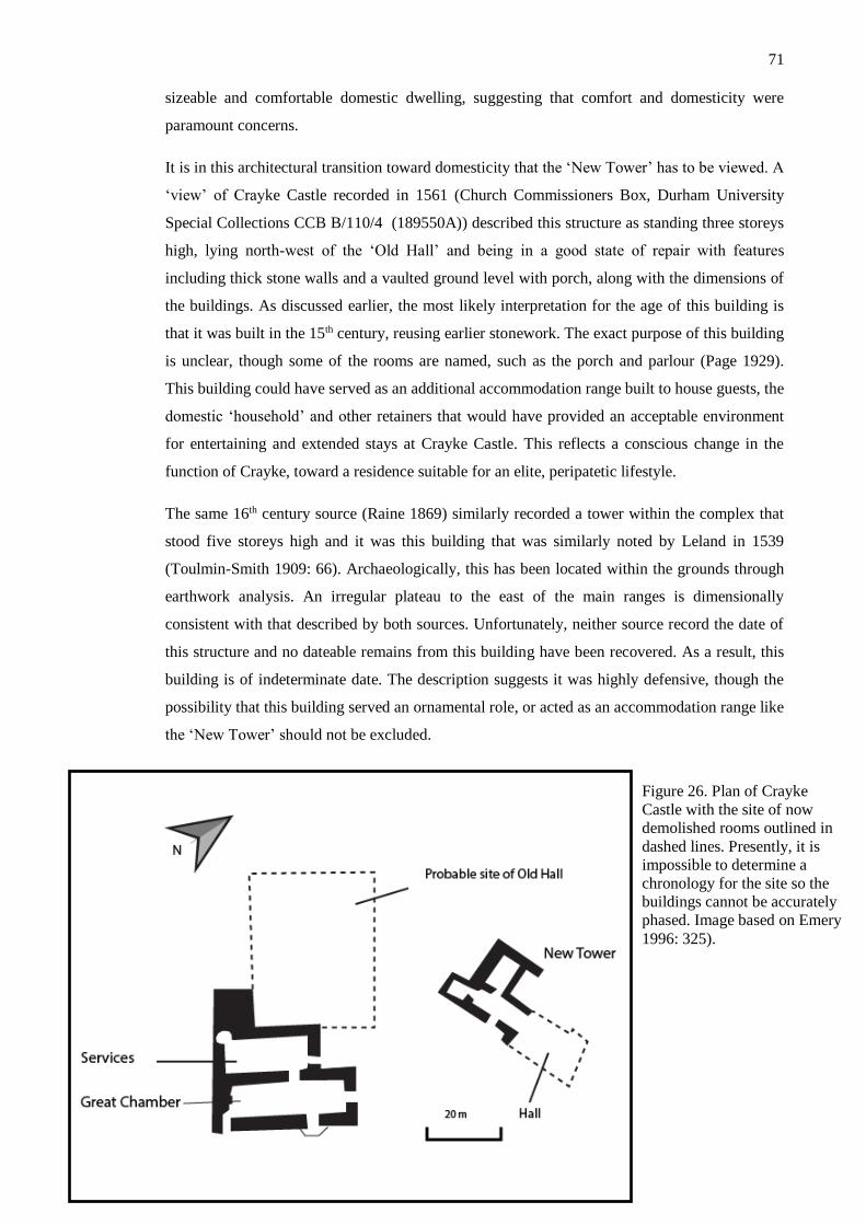
71
sizeable and comfortable domestic dwelling, suggesting that comfort and domesticity were
paramount concerns.
It is in this architectural transition toward domesticity that the ‘New Tower’ has to be viewed. A
‘view’ of Crayke Castle recorded in 1561 (Church Commissioners Box, Durham University
Special Collections CCB B/110/4 (189550A)) described this structure as standing three storeys
high, lying north-west of the ‘Old Hall’ and being in a good state of repair with features
including thick stone walls and a vaulted ground level with porch, along with the dimensions of
the buildings. As discussed earlier, the most likely interpretation for the age of this building is
that it was built in the 15th century, reusing earlier stonework. The exact purpose of this building
is unclear, though some of the rooms are named, such as the porch and parlour (Page 1929).
This building could have served as an additional accommodation range built to house guests, the
domestic ‘household’ and other retainers that would have provided an acceptable environment
for entertaining and extended stays at Crayke Castle. This reflects a conscious change in the
function of Crayke, toward a residence suitable for an elite, peripatetic lifestyle.
The same 16th century source (Raine 1869) similarly recorded a tower within the complex that
stood five storeys high and it was this building that was similarly noted by Leland in 1539
(Toulmin-Smith 1909: 66). Archaeologically, this has been located within the grounds through
earthwork analysis. An irregular plateau to the east of the main ranges is dimensionally
consistent with that described by both sources. Unfortunately, neither source record the date of
this structure and no dateable remains from this building have been recovered. As a result, this
building is of indeterminate date. The description suggests it was highly defensive, though the
possibility that this building served an ornamental role, or acted as an accommodation range like
the ‘New Tower’ should not be excluded.
Figure 26. Plan of Crayke
Castle with the site of now
demolished rooms outlined in
dashed lines. Presently, it is
impossible to determine a
chronology for the site so the
buildings cannot be accurately
phased. Image based on Emery
1996: 325).

72
Figure 27. Plan of Norham Castle. Drawn by author based on Salter (2009) and Saunders (1998:28).
Norham Castle – Norham, Northumberland.
Norham Castle stands today as one of the most famous castles in the historically militarised
Scottish border zone. Through history it has played an important role as the sight of numerous
battles and political events (Sadler 2013). In peaceful times Norham Castle continued to remain
a relevant building, predominantly due to its ‘romantic’ aesthetic captured by Turner in the 19th
century and as the backdrop for Scott’s epic poem (1936) (Finlay 1980). Because of the
enduring popularity of this site, significant historical work has been conducted tracing its
history and development. Influentially, Philip Dixon and Pamela Marshall (1993) have
reassessed the archaeological and historical evidence surrounding Norham Castle, presenting
new interpretations based on the standing buildings evidence of the development and use of the
central donjon, whilst the Heritage Lottery funded Flodden Project has conducted
archaeological investigation into the unscheduled outer ward region of the site (Waddington and
Brightman 2013).
Norham Castle held a particularly valuable role to the bishops of Durham, not only as their
borderland stronghold, but also as the capital of Norhamshire. The bishops attained their
exclave of Norhamshire during the early medieval period, and it was first mentioned alongside
lands held on Lindisfarne in 995 AD (Lewis 1848). They governed this exclave, like others at
Bedlingtonshire and Islandshire, as an arm of their bishopric. Because of Norhamshire’s
location on the Scottish borders, it became an essential asset to the bishops of Durham in their
efforts to suppress Scottish incursions.

73
Phase One – Timber castle or stone donjon? (12th Century)
While this castle features prominently in many historical events of national importance the
origin of this building and the nature of it during its earliest days are contested. Traditional
scholarship has attributed the origin of the castle to Bishop Ranulf Flambard (1099-1128)
following his order in c.1121 for its construction to defend against the ‘Scottish Threat’ (Bartlett
2000:281; Pettifer 1995:193; Dodds 1988:27; Mackenzie 1825:332; Platt 1982:40; Allsop and
Clark 1970). The first phase of this building is thought to have been a motte-and-bailey castle,
and the earthworks indicating this are still prominent in the landscape. Recent archaeological
excavation was conducted (Brightman and Waddington 2013) to date these following
speculations by Pearson (2002) that a prehistoric feature might have been incorporated within
the motte earthworks. A 2013 investigation (Brightman and Waddington 2013) yielded few
dateable archaeological remains, with those that were discovered suggesting that the earthworks
excavated were the result of post-medieval remodelling of the area. As a result, this
investigation was not conclusive in proving whether or not the earliest phases of this site reused
prehistoric earthworks within the motte.
The earliest structures at this site have been traditionally interpreted to have been of timber
construction. Following two well documented attacks by the Scots in 1136 and 1138, Norham
Castle suffered ‘extensive damage’ and a period of abandonment and ruination seemed to have
followed thereafter (Sadler 2013). Historical documentation is clear on its ‘reconstruction’ by de
Puiset (1153 - 1195) following orders by King Henry II (Saunders 1998:20). This evidence
suggests therefore, that the stone donjon dates from this set of building works.
Dixon and Marshall (1993) have through extensive standing buildings analysis, challenged this
assertion. They concluded that parts of the stone donjon were ‘almost certainly the work of
Flambard c. 1121’ (1993: 428) and that the donjon at this time featured a sizeable hall and was
later sub-divided into smaller rooms and spaces (Dixon and Marshall 1993: 428). This re-
evaluation of the standing buildings evidence alters how we interpret the phasing suggested
through the historical record, and more precisely challenges the understanding that Norham
Castle once had a timber structural phase.
Also dating from the 12th century are large aspects of the still-standing outer and inner wards. It
has been suggested that the Outer Ward dates from Flambard’s structure, though this this has
not been confirmed archaeologically (Saunders 1998:20). Le Puiset is known to have
commissioned the Inner Ward gatehouse and West Gate in addition to repairing the Great
Tower (donjon) (Saunders 1998: 20). It has been suggested that the Outer Ward was a product
of Flambard though no archaeological evidence appears to confirm this (Saunders 1998:20).

74
Archaeologically, le Puiset’s building efforts aside from the Great Tower include the very
earliest phases of the Inner Ward (Saunders 1998).
Ward gatehouse and West Gate (Saunder 1998). The phasing of Sheep Gate coincides with a
known expenditure by King John on the castle in 1212 (Saunders 1998: 21). Much of the
complex was strengthened by Bishop Fox, and the aqueduct system was added by him to
provide both a clean water supply and water to fill the moat. The presence of buildings
associated with wool production located near the water sources have been attributed to this
building phase also (Saunders 1998:21).
Phase Two (13th/14th centuries)
The end of the 12th/beginning of the 13th century was a period of substantial turbulence in the
history of Norham Castle. It was during this period that Norham Castle transitioned between
royal ownership and possession by the bishops of Durham (Saunders 1998: 21). While Norham
Castle was possessed by the bishops of Durham following Poitou’s death in 1208, King John
spent considerable sums of money updating and improving Norham Castle (Saunders 1998: 21).
The Sheep Gate has been stylistically dated to this phase (Saunders 1998: 21). In addition, a
royal garrison was installed at Norham Castle between c. 1208 – 1211 (Fraser 1961: 128-9). It is
probable that the remains of structures relating to this period remain at the site as below-ground
deposits. Aside from these events there are no further textural or archaeological records relating
to building expenditure by the King at Norham Castle, despite this period being known for
sustained and repeated attacks at this castle (Aiken 1808: 139).
Phase Three (15th/16th centuries)
In contrast to the 14th century, the 15th century is notable for the scale and extent of building
work conducted at Norham Castle. Firstly, a new stone tower named ‘Westgate’ was built
between February and December 1408 (Church Commissioners Box, Durham University Special
Collections, CCB B/72/2 (190003)). The account records that the tower was topped with a
wooden palisade made from timbers imported to Berwick from the Baltic. Twenty years later a
similar account records the building of a new latrine attached to the south-west side of the Great
Tower, construction below the vent of the dungeon beneath the Great Tower, building of a stone
encasement for suspending the portcullis and a lean-to structure next to the ‘Westgate’ to shelter
oxen and the builders (Church Commissioners Box, Durham University Special CCB B/72/3
(190008))
The structural additions proved valuable upon the beginning of the 16th century, when Norham
Castle was severely damaged in siege of 1497 (famous for the canon ‘Mons Meg’ having been
used) (Drees 2014: 39). In 1510-1511, there are accounts amounting £350 for repairs made to
the castle, though the precise nature of these repairs is not known as this source only details the
75
wages each labourer/craftsman received and the materials used (,Church Commissioners Box,
Durham University Special Collections CCB B/72/10 (221030A)).
In addition, the donjon was significantly altered in this period. Firstly, it was heightened and an
additional staircase inserted in 1422-25, and then at the end of the 15th century the roof was
flattened and additional. These changes together with the reconfiguration of the internal spaces
have led Dixon and Marshall to state that these changes are a reflection of the changing role of
the building in later periods. Saunders (1998: 21) concluded that following the Treaty of
Northampton, the bishops created a ‘tower-house’ from the original defensive donjon.
Durham Castle – Durham, Co. Durham
Durham Castle is situated on an elevated motte on Durham peninsula. Durham Castle is located
at the narrowest point of this peninsula, blocking free flowing access to the tip of the peninsula
inhabited by Durham Cathedral. Like Auckland Castle, Durham Castle has remained an actively
used residence to the present day. In 1832 the castle was given from the bishopric estate to help
found Durham University (Brickstock 2007: 56). Because of its enduring use, Durham Castle
has remained in good state of repair. Today therefore, it stands as one of the most intact
examples of a Norman castle in Britain and is one of the major landmarks in Durham.
Phase One – 11th/12th centuries
The earliest developmental phases of Durham Castle appear to have been of great interest to
scholars. Martin Leyland (1994) wrote his doctoral thesis examining the development of the
castle from 1071 to 1217. Many have debated the precise structural order of buildings in the
Durham Castle precinct (Leyland 1994, Wood 2010, Page 1928) but most agree that there was
some pre-Conquest structure beneath the site of the current Durham Castle. Leyland has
concluded that some of this fabric can be identified in the basement of the North Hall while
there has been suggestion that the northern wall of the Norman Chapel might incorporate earlier
fabric (Page 1928).
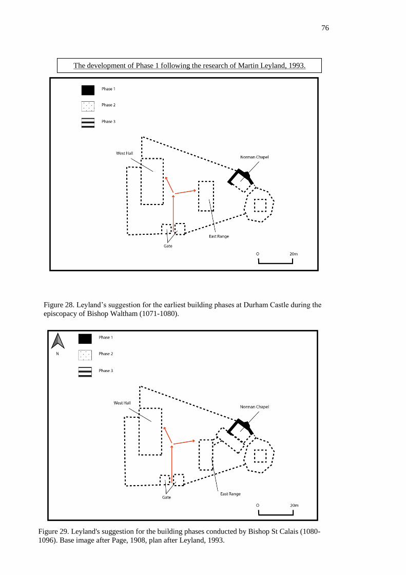
76
Figure 28. Leyland’s suggestion for the earliest building phases at Durham Castle during the
episcopacy of Bishop Waltham (1071-1080).
Figure 29. Leyland's suggestion for the building phases conducted by Bishop St Calais (1080-
1096). Base image after Page, 1908, plan after Leyland, 1993.
The development of Phase 1 following the research of Martin Leyland, 1993.

77
Figure 30. Image depicting the building work of Bishop Flambard (1099 - 1128). Base
map after Page, 1908 and plan after Leyland, 1993.
Figure 31. Image depicting the building work of Bishop Puiset (1153 - 95). Base
map after Page, 1908 and plan after Leyland, 1993.

78
Despite this, there seems to be a general consensus that the earliest phases of the Durham Castle
were built by Bishop Walcher in 1072. Leyland has traced a possible outline for the buildings at
this time, and he concluded that their arrangement is more reminiscent of secular castle design
than episcopal. The reasons for this are most likely as a response to the instability in the region,
the Historia Regum explains this decision as providing a safe home for his appointee.
(Thompson 1994). The earliest arrangement of buildings within the Durham Castle precinct
therefore seems likely to have consisted of a motte, chapel, gateway, curtain wall and hall. This
collection of spaces is highly typical of Norman castle design, and echoes the other very early
bishops’ residence at Norham.
The Norman Chapel has long been a focus for academic scholarship because of its unique,
unaltered survival and interesting Norman carved stones. The Norman chapel is a small, one
storeyed room abutting the outer curtain wall and motte. The north wall features in situ remains
of the northern curtain wall. Inside, it is noted for its unusual carved Romanesque stonework
which features, among other things, a figure of a mermaid and dogs. Most recently Rita Wood
(2010) has reassessed the structural remains and concluded that due to the obvious Norman
Figure 32. Phase plan of Durham Castle. While Phase One has been discussed and depicted in detail, due to the
lack of surviving material from Phase Two combined with the fact that it occupied the same structural footprint,
these two phases have been illustrated on the same plan. Based on Page, 1908.

79
influences, it would have had to have been built by a Norman bishop (Wood 2010: 44). She
concludes that William St Calais (1080 – 1088) built the chapel during his episcopacy.
Of similar antiquity is the under croft beneath the ‘west’ hall. Still in use today, the under croft
appears to have outlived its accompanying hall. Inside the under croft are in situ Norman
stonework and vaulting suggesting it had once accommodated a sizeable superstructure the hall
it had accompanied has since been demolished. Judging by the date of the under croft, this was
the initial location of the hall. Pevsner (1983: 217) states that excavations north of the West Hall
uncovered the remains of service spaces. Meanwhile, excavations conducted in the courtyard by
Leyland (1994) uncovered the remains of a further stone building. This building might therefore
represent the otherwise illusive domestic spaces for the bishop.
The subsequent decades saw a linking range inserted between the Norman chapel and East
Range (Leyland 1994: 416), while Bishop Flambard was responsible for the insertion of a
second range at the beginning of the 12th century. This North Hall was positioned opposing
newly located front gate, with the famous first-floor entranceway positioned directly aligned
with this gateway. This arrangement creates a new focus for the complex, switching the
perspective from the West Hall toward the North Hall. The presence of a second storey doorway
adds credence to this idea, as the elevated position would have encouraged the viewers gaze
higher, resulting in an imposing and dramatic entranceway. Internal analysis of the North Hall
shows it to have possibly had a two storey arrangement, with a lower storey constable’s hall and
second storey bishop’s hall (Leyland 1994: 422). The clerestory level windows are cited as
evidence for this but might just as easily be proof of a gallery level.
Phase 2 – (13th/14th centuries)
With a substantial building plan already in place by the beginning of the 13th century, Durham
Castle was in stark contrast with the vast majority of other residences owned by the bishops of
Durham. The first noticeable change from this period was the replacement of the West Hall
(Great Hall) by Bek (1284-1310), though this was latterly enlarged by Bishop Hatfield (1345-
1381). In addition, Hatfield rebuilt the keep in stone, though this has since been replaced (Raine
1839: 150; Brickstock 2007: 63). Hatfield’s keep from this time was described in Hutchinson as
tall, narrow, ill-formed and attractive (1794: 368). The impression that is cast by Hutchinson is
of a tower designed for aesthetic value rather than defensive means. Arguably, these structural
additions show a greater departure away from the defensive style obvious in Phase One. Both of
these structural changes have been largely rebuilt with the keep and West Hall in their direct
footprint. Only some small traces of original masonry still exist in situ.

80
Phase 3 - (15th century)
In the intervening years between Hatfield (1345 – 1381) and Bishop Fox (1494-1501) only the
gateway was significantly altered (Ref). Bishop Fox reconfigured Hatfield’s Great Hall back to
the dimensions of Bek’s initial hall. In so doing, most of the fabric from Hatfield’s hall was lost,
and only some remnants of Bek’s initial hall were reused in both designs, notably the
impressive stone doorway. In addition, Fox subdivided the new hall and he built to
accommodate his kitchen and associated rooms. Today, Fox’s additions comprise the majority
of buildings within the footprint of Durham Castle.
Summary
Therefore, what we have seen is that Durham Castle develop rapidly through the medieval
period, assuming new ranges and an increased expenditure on domestic spaces. There has been
much debate over whether to term this building a palace or castle (Thompson 1994) and this
relates to much wider debates over the precise nature of a castles and appropriate terminology
(Stocker 1994). However, at Durham Castle there is clear evidence to suggest that its
appearance in terms of display, through the conscious placement of entranceways and halls,
reveals that the aggrandisement of the bishop was an important aspect of its construction and
role.
Sites with few or no standing remains.
Darlington Manor – Darlington, Co. Durham
Darlington bishop’s residence was reportedly built in c. 1164 by Bishop le Puiset (Clack and
Pearson 1978:8) though relatively little historical information exists relating to the medieval
phases of occupation, with the latter post-medieval developments better recorded historically.
Of the few historical reports available, we know that the bishops maintained the building into
the post-medieval period, with repairs commissioned to the buildings following the Darlington
Fire in 1668 (Longstaffe 1854: 60). Moreover, an antiquarian report from 1703 records that the
residence was in use as a Quaker Workhouse though owned (but not administered) by the
bishops of Durham until 1808 whereby it was sold, as a workhouse, to the town of Darlington.
The buildings were sold in 1870 to Richard Luck and ultimately destroyed to make room for
new houses (Longstaffe 1854: 153). However, the most revealing records regarding the form
and layout of the medieval residence are post-medieval maps and illustrations from its duration
as a workhouse.
The 1st Ordnance Survey map of the area from 1856 provides the clearest cartographical record
of the site. Depicted is the ground plan of the 19th century workhouse with the ‘Old Hall’
labelled. The ‘Old Hall’ stands in contrast with the newer workhouse ranges due to the thicker
walls and larger room size typical of medieval architecture. From this image it can be discerned

81
that this building displays characteristics from two building phases. An architects illustration
(H.D Pritchett, Durham County Council HER) drawn 10 years after the Ordnance Survey map
supports this interpretation by depicting the building with the same characteristics. It can
therefore be suggested from these images that the ‘Old Hall’ is an original surviving feature
from the medieval bishop’s residence, while the north-south orientated range is a later feature,
probably associated with the workhouse.
Two key illustrations from the 18th and 19th centuries support this theory. Both these images
portray the Darlington residence in the intervening years between its transformation into a
workhouse and any 19th century alteration to the main building. The earliest, dated from 1764
(Darlington Local Studies Library (acc. no. PH5067 L566A) depicts the east face of the
medieval residence, while an illustration dating from 1813 (reproduced in Hammond 2014)
portrays the same building from the west. Both these images show an L-shaped configuration
with the ‘Old Hall’ projecting eastwards towards the river. On the projecting easternmost wall,
the hall features three tall, statement windows (also included on Pritchett’s plan that would have
framed views over the river and episcopal parkland beyond. The adjoining range would have
most likely held the domestic spaces. In both images it is clear that this range was heavily
ornamented with decorative stonework consistent with medieval architectural design. Moreover,
the heavily ornamented doorway on the western aspect depicted in Fig. 45 suggests that was the
main point of access into the building, indicating that the building was designed serve as a
vantage point over the landscape beyond. According to these images the bulk of the decorative
stonework appeared on the western, access side. It is possible to infer from this that the
stonework was intended to be seen by guests upon arrival.
Peter Ryder (2013) has suggested that the placement of the largest and most decorative
windows on the first floor could indicate that the hall was positioned at the first floor level
(ASUD 2014: 49). He cites the lack of cross-passage entry, as is a typical feature of other
Figure 33. 1'st Edition OS Map,
clearly showng the bishops
residence adjoined to later
workhouse features
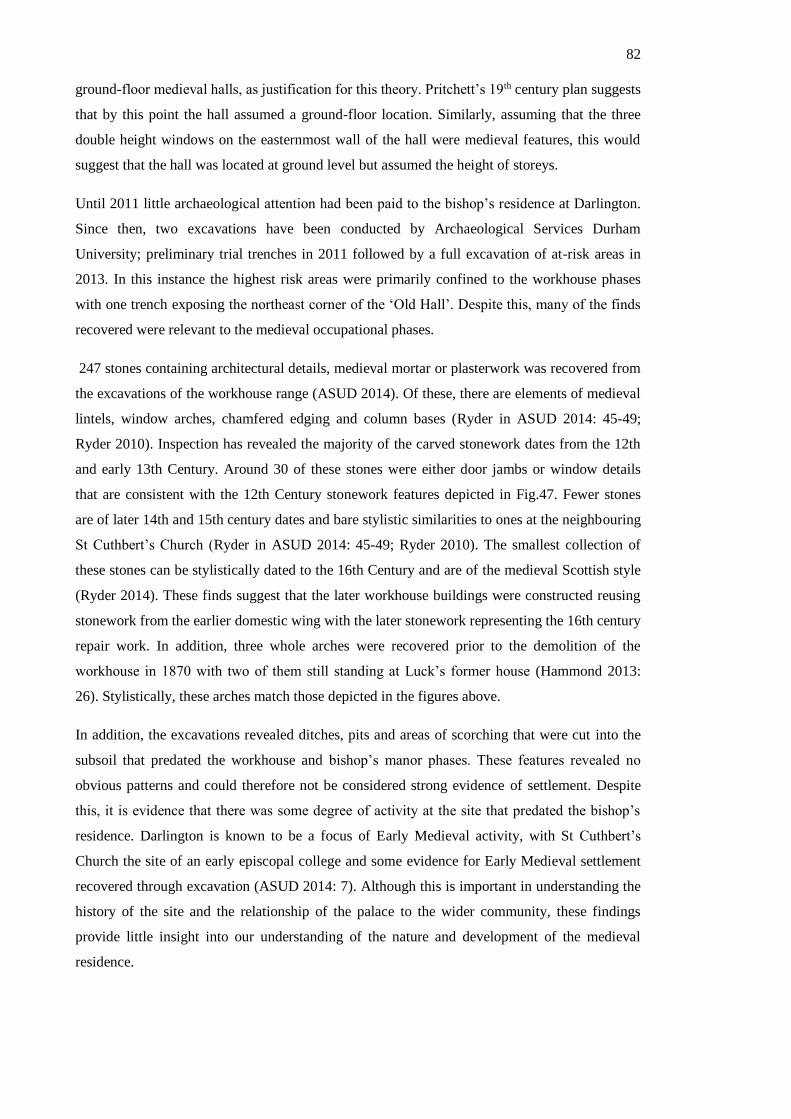
82
ground-floor medieval halls, as justification for this theory. Pritchett’s 19th century plan suggests
that by this point the hall assumed a ground-floor location. Similarly, assuming that the three
double height windows on the easternmost wall of the hall were medieval features, this would
suggest that the hall was located at ground level but assumed the height of storeys.
Until 2011 little archaeological attention had been paid to the bishop’s residence at Darlington.
Since then, two excavations have been conducted by Archaeological Services Durham
University; preliminary trial trenches in 2011 followed by a full excavation of at-risk areas in
2013. In this instance the highest risk areas were primarily confined to the workhouse phases
with one trench exposing the northeast corner of the ‘Old Hall’. Despite this, many of the finds
recovered were relevant to the medieval occupational phases.
247 stones containing architectural details, medieval mortar or plasterwork was recovered from
the excavations of the workhouse range (ASUD 2014). Of these, there are elements of medieval
lintels, window arches, chamfered edging and column bases (Ryder in ASUD 2014: 45-49;
Ryder 2010). Inspection has revealed the majority of the carved stonework dates from the 12th
and early 13th Century. Around 30 of these stones were either door jambs or window details
that are consistent with the 12th Century stonework features depicted in Fig.47. Fewer stones
are of later 14th and 15th century dates and bare stylistic similarities to ones at the neighbouring
St Cuthbert’s Church (Ryder in ASUD 2014: 45-49; Ryder 2010). The smallest collection of
these stones can be stylistically dated to the 16th Century and are of the medieval Scottish style
(Ryder 2014). These finds suggest that the later workhouse buildings were constructed reusing
stonework from the earlier domestic wing with the later stonework representing the 16th century
repair work. In addition, three whole arches were recovered prior to the demolition of the
workhouse in 1870 with two of them still standing at Luck’s former house (Hammond 2013:
26). Stylistically, these arches match those depicted in the figures above.
In addition, the excavations revealed ditches, pits and areas of scorching that were cut into the
subsoil that predated the workhouse and bishop’s manor phases. These features revealed no
obvious patterns and could therefore not be considered strong evidence of settlement. Despite
this, it is evidence that there was some degree of activity at the site that predated the bishop’s
residence. Darlington is known to be a focus of Early Medieval activity, with St Cuthbert’s
Church the site of an early episcopal college and some evidence for Early Medieval settlement
recovered through excavation (ASUD 2014: 7). Although this is important in understanding the
history of the site and the relationship of the palace to the wider community, these findings
provide little insight into our understanding of the nature and development of the medieval
residence.
83
Figure 35. In blue is the outline of the bishops residence alongside the excavation area. The red
squares represent the trenches excavated during this study. Drawn by the author using
information from (ASUD 2014) and 1st Edition OS map (1858).
Bishop Middleham Castle - Bishop Middleham, Co. Durham
Bishop Middleham Castle survives today as earthworks confined to a rocky outcrop abutting
Bishop Middleham village. The site is surrounded by marshy land prone to intermittent
flooding, leaving the ‘castle top’ exposed. The site is currently used as land for grazing animals,
and due its topographical situation, seems unlikely to have been subject to intensive ploughing
in the past. As a result, it is reasonable to believe that there are considerable well-preserved
below-ground deposits remaining. Unlike other sites, substantially less is known regarding the
sequence and development of Bishop Middleham Castle. This is stems from the fact that Bishop
Middleham Castle was in use for a substantially shorter timespan than other sites. The site is
recorded as having been sold by the see of Durham in 1649 and it is has been suggested that
Bishop Middleham Castle was ruined by this point (Gibson 1848: 55). The itineraries of the
bishops of Durham (see Appendix 1) record a severe decline in attendance at Bishop
Middleham Castle from the mid-14th Century onwards, supporting the interpretation that this
site suffered gradual abandonment and subsequent dilapidation as a result of its unpopularity
with later High Medieval. Unlike other residences, Bishop Middleham Castle did not maintain a
substantial standing edifice into the modern period and is reported as having its last surviving
feature (a vaulted under-croft) demolished in the 19th Century with Gibson (1848:55)
suggesting that some of the stones were reused in the creation of Island Farm south-east of the

84
site. This possibility has never been archaeologically explored, and with no known images of
the buildings, little is known about its
.
Figure 36. Earthwork survey conducted as part of a training exercise at Durham University,
1999. The letters correspond to those overleaf.
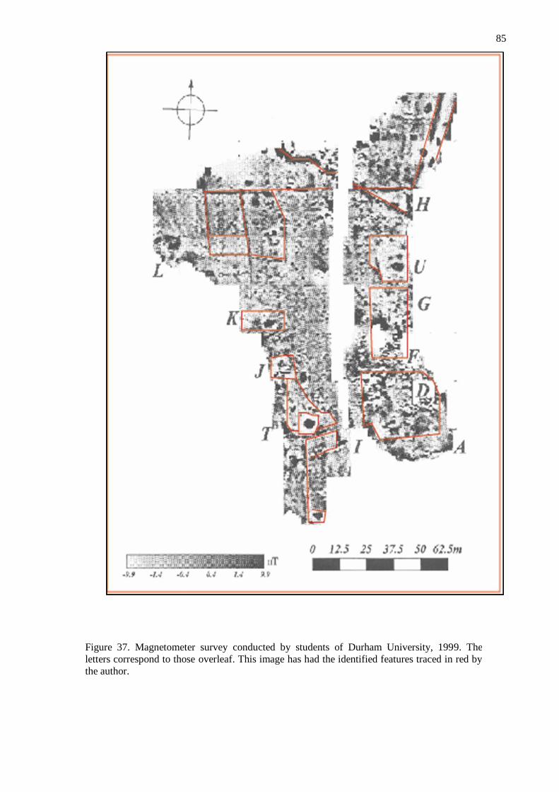
85
Figure 37. Magnetometer survey conducted by students of Durham University, 1999. The
letters correspond to those overleaf. This image has had the identified features traced in red by
the author.
86
upstanding character and edifice. Crucially however, it is because of this lifetime of
abandonment and neglect that we are today presented with a unique opportunity to understand
an unadulterated example of early episcopal residential design.
The Boldon Book (c1183) refers to Bishop Middleham settlement being owned by the bishops
of Durham (Austin 1982), and it has been suggested that this could indicate the beginning of a
residence at the site (DCC 1998). The earliest definitive historical references to a residence at
Bishop Middleham are the documentary records from the episcopacy of Bishop Poitou (1197-
1208) (Greenwell 1871: 250). Poitou succeeded de Puiset and is not known as a key palace
builder like his predecessor, de Puiset. With this in mind, it is probable that le Puiset (1154-
1195) was responsible for the initial construction of a residence at Bishop Middleham. This
therefore, places the origin of this Bishop Middleham Castle within the mid-to-late 12th
century.
Multiple historical references from the 14th century indicate the expansion and continued
occupation of this site. Records dating between 1316 – 1333 (primarily the episcopacy of Louis
de Beaumont) report the construction of a kitchen, hall and chapel and subsequent repairs in
1349 (Raine 1839:119). These rooms are typical of episcopal palace design and their inclusion
in the early 14th Century supports the evidence from itineraries (see Appendix 1) indicating that
Bishop Middleham Castle was a popular point of habitation for the 13th and early 14th Century
bishops. The death of two bishops (Robert of Holy Island (Raine 1839: 119) and Richard
Kellawe (Hardy 1873: 180) at this site further emphasises the importance of this location and
provides ample justification for the building achievements recorded during the early 14th
Century. Noteworthy therefore, is the report from 1384 in Hatfield’s Survey that ‘juratores
dicunt quod manerium de Middelham nichil valet ultra reprisas’ (the jurors say that the Manor
of Middleham is worth nothing’ (Greenwell 1857: 183)). This reference almost certainly
includes the palace site within the rest of the episcopal manorial land in Bishop Middleham
(Jackson 1996).
Archaeological investigation appears to substantiate what is known through historical evidence.
An earthwork survey records two rectilinear depressions (U and G) enclosed by stonework that
are consistent with medieval buildings and later agricultural features. However, the stonework
visible at Feature (U) is of a less substantial nature than that at Feature (G). The walls are not
mortared or of even construction which contrasts with the thick, mortared walling with visible
entryway or window in Feature D. This suggests that the northernmost east-west orientated wall
in Feature D is an original medieval feature while the other walls are more recent building
efforts, possibly to create small animal enclosures. With this in mind, it is therefore possible that
the depressions these ‘walls’ are associated with are also later features and not indicative of the
medieval structural arrangement.

87
• Feature T is the only other clearly defined visible earthwork. This circular
depression is consistent with the form of a well and this is corroborated in
geophysical plans of the site. The magnetic response for this feature is strongly
positive and assumes the same shape as the earthwork. This is consistent with
typical responses for a ditch infill, possibly indicating the site of an infilled
well.
• Feature U appears on the geophysical survey as a rectilinear feature of very
positive magnetic response with three circular zones of negative response. This
aligns with a plateaued feature on the earthworks. These features could relate to
the kitchen mentioned from historical sources and are consistent with an area of
dense, flat stonework and concentrated zones of burning. From this evidence it
is possible that this is a stone floor surface and hearths although this is
impossible to confirm without more intrusive archaeological investigation.
• Features G and D that feature prominently on the earthwork survey appear
magnetically ‘noisy’ suggesting that there is an irregular formation of
stonework beneath ground that is consistent with demolition stonework and
rubble. A similar patterns of magnetic ‘noisiness’ are apparent on the western
side of the promontory suggesting the same irregular stony below-ground
deposits. It is possible that in these zones, stone medieval buildings stood and
the layout and form of which is obscured in survey by rubble from their
demolition.
• Interestingly, Features L do not align with any earthwork feature. These
rectilinear negative features are consistent with a series of ditches and connect
to a longer ditch feature running east-west across the peninsula neck (Feature F.
This unusual arrangement suggests that they are connected with Features L
respecting Feature F as its northernmost boundary. It is possible that Feature F
is a boundary feature that comprised of a ditch and potentially and associated
wooden fence or palisade. From this, two small enclosures extended with an
additional smaller enclosure attached to the south. Their size and form would
have been suitable for containing animals in. Without further archaeological
investigation it is not possible to know the date of these features or how they
relate to the rest of the site. If they medieval, it suggests that the site was
defensively and/or symbolically separated from the rest of the community by a
wooden barrier.
The farm buildings north of the peninsula are of similarly historic character. Surtees (1823)
stated that these buildings might have served as ‘offices’ for the castle, though there is not
further evidence to suggest this. A cursory inspection of the buildings has revealed that some

88
might contain medieval masonry within later fabric though it is unclear whether any are entirely
medieval in date. It seems highly probable that given their close proximity to the ‘castle top’
that some original stonework was incorporated into their construction. Overall however, the
precise relationship between the castle and these buildings is unknown.
Assuming that the above and below-ground stonework to be medieval in date (with the
exception of features F and L the buildings appear to cluster along the eastern and western edges
of the site leaving the central region empty. As the southern extent hasn’t been appropriately
geophysically surveyed, it is possible that the complex extended on three sides to incorporate
the southern end of the promontory. This would suggest that the complex might have had three
ranges surrounding a central courtyard; a shape repeated at other sites, namely Seaton Holme
and Howden. The presence of possible animal or garden enclosures within the complex
highlights the importance of the outdoor space within the wider enclosure. It is possible that,
Bishop Middleham Castle comprised more than one building and instead incorporated various
ranges and outdoor enclosures that although not all connected, all played important parts in the
spatial configuration of the residence.
As at Durham Castle, Crayke Castle and Durham Castle, Bishop Middleham Castle appears to
have had a defined boundary separating the site both physically and symbolically from the
surrounding settlement, though unlike these sites this boundary appears to have been wooden. It
is not clear whether this site was truly defensive therefore, or whether it reflects an earlier
construction style that has not survived elsewhere. The implication of this is the creation of a
separate complex of buildings cut-off from the wider community, serving to add additional
layers of spatial division between the bishop and the community.
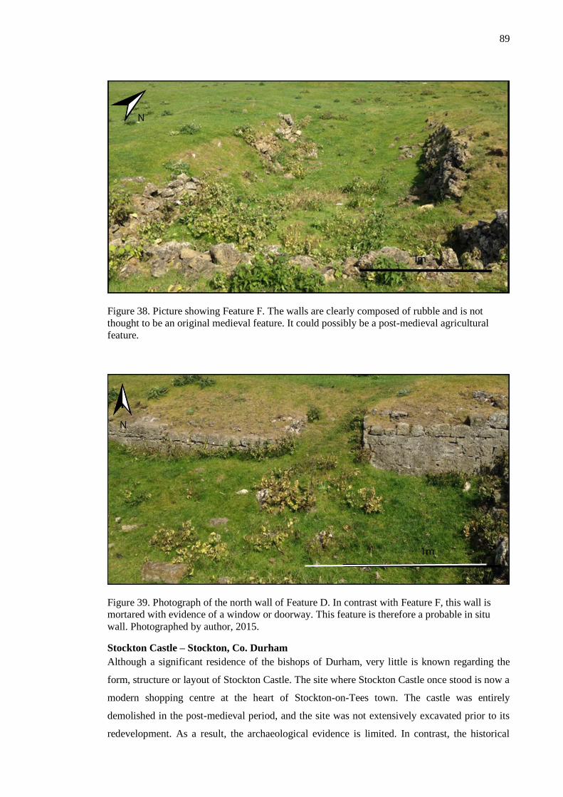
89
Figure 38. Picture showing Feature F. The walls are clearly composed of rubble and is not
thought to be an original medieval feature. It could possibly be a post-medieval agricultural
feature.
Figure 39. Photograph of the north wall of Feature D. In contrast with Feature F, this wall is
mortared with evidence of a window or doorway. This feature is therefore a probable in situ
wall. Photographed by author, 2015.
Stockton Castle – Stockton, Co. Durham
Although a significant residence of the bishops of Durham, very little is known regarding the
form, structure or layout of Stockton Castle. The site where Stockton Castle once stood is now a
modern shopping centre at the heart of Stockton-on-Tees town. The castle was entirely
demolished in the post-medieval period, and the site was not extensively excavated prior to its
redevelopment. As a result, the archaeological evidence is limited. In contrast, the historical

90
documentation relating to Stockton Castle is unusually detailed and provides an impression of
the castle’s medieval structural phases.
Stockton Castle was a nationally important site. King John is known to have visited in 1214 and
Bishop Farnham is known to have retired to Stockton Castle in 1249 (Surtees 1823: 170).
Despite this, our earliest reference to any building at the site is a document from the 12th
century that records Bishop le Puiset as having a ‘hall’ in Stockton (Page 1928). It is not clear
whether this ‘hall’ corresponds with Stockton Castle, but it is probable given a 13th century
source that details people having stayed at Stockton Castle
A 16th century survey provides the most detailed record relating to Stockton Castle. It was
recorded following the death of Bishop Pilkington (1576) and has been transcribed in full by
Raine (1876) and Sowler (1972). In it, the state of repair of different parts of the complex
providing the dimensions, and in some cases, the location of buildings relative to others is
recorded. This is an illuminating text that provides an impressive snapshot into a moment in
time shortly after the end of the medieval period.
Notably, the typical collection of spaces associated with episcopal residences are present, for
example the hall and the chapel. The ‘decaying’ towers described allude to the building having
once had a highly defensive form. These towers, that stood at ’12 yards high’, would have
loomed over the other buildings, such as the ‘5 yard’ high barn. As a result, the picture this
source conjures is of a complex suitable for domestic habitation but also with a keen
preoccupation with defence, or the expression of defence.
Despite the importance of this site as a popular residence of the bishops of Durham, Stockton
Castle has only been archaeologically examined once, shortly before the site was redeveloped to
accommodate a carpark and shopping centre in 1965 (Aberg and Smith 1988). The excavators
were limited to a two-week excavation and encountered issues from modern stratigraphic
disturbance that hindered progress and results (Aberg and Smith 1988). The excavations were
not extensive or wide-ranging enough to provide any clear evidence with which to begin
suggesting a plan for the buildings. Despite this, the excavations did reveal some important
discoveries:
1) Firstly, two stone-built drains were recovered, both of which contained only
medieval pottery and one (Drain 1) incorporated 12th century masonry. Analysis of
this masonry suggests that it came from a high-status stone building, possibly a hall,
from around c. 1150. This masonry was therefore reused in the construction of these
drains. These particular architectural fragments include a column fragment with
waterleaf and square-abacus design and decorative string-courses with octagonal
bosses and a fragment of Frosterley Marble (Aberg and Smith 1988: 185). There
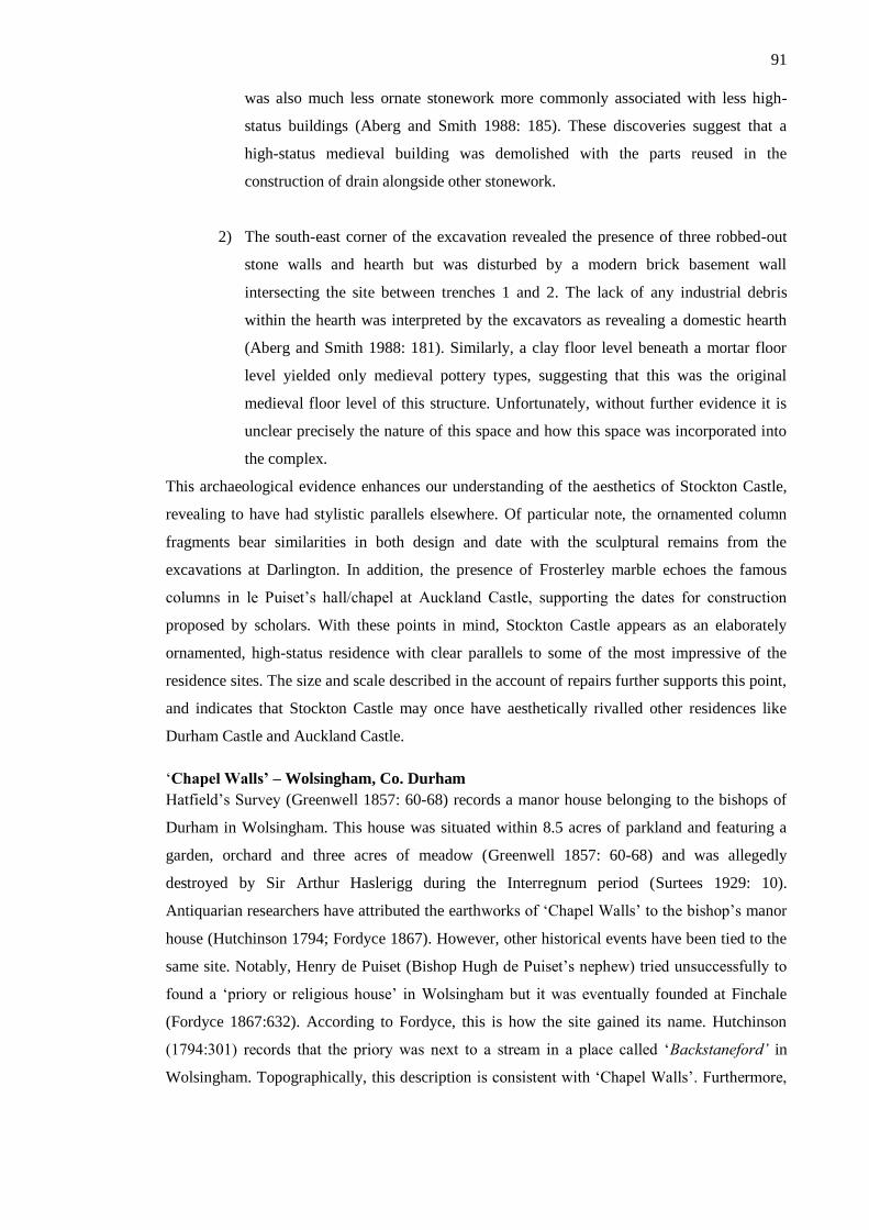
91
was also much less ornate stonework more commonly associated with less high-
status buildings (Aberg and Smith 1988: 185). These discoveries suggest that a
high-status medieval building was demolished with the parts reused in the
construction of drain alongside other stonework.
2) The south-east corner of the excavation revealed the presence of three robbed-out
stone walls and hearth but was disturbed by a modern brick basement wall
intersecting the site between trenches 1 and 2. The lack of any industrial debris
within the hearth was interpreted by the excavators as revealing a domestic hearth
(Aberg and Smith 1988: 181). Similarly, a clay floor level beneath a mortar floor
level yielded only medieval pottery types, suggesting that this was the original
medieval floor level of this structure. Unfortunately, without further evidence it is
unclear precisely the nature of this space and how this space was incorporated into
the complex.
This archaeological evidence enhances our understanding of the aesthetics of Stockton Castle,
revealing to have had stylistic parallels elsewhere. Of particular note, the ornamented column
fragments bear similarities in both design and date with the sculptural remains from the
excavations at Darlington. In addition, the presence of Frosterley marble echoes the famous
columns in le Puiset’s hall/chapel at Auckland Castle, supporting the dates for construction
proposed by scholars. With these points in mind, Stockton Castle appears as an elaborately
ornamented, high-status residence with clear parallels to some of the most impressive of the
residence sites. The size and scale described in the account of repairs further supports this point,
and indicates that Stockton Castle may once have aesthetically rivalled other residences like
Durham Castle and Auckland Castle.
‘Chapel Walls’ – Wolsingham, Co. Durham
Hatfield’s Survey (Greenwell 1857: 60-68) records a manor house belonging to the bishops of
Durham in Wolsingham. This house was situated within 8.5 acres of parkland and featuring a
garden, orchard and three acres of meadow (Greenwell 1857: 60-68) and was allegedly
destroyed by Sir Arthur Haslerigg during the Interregnum period (Surtees 1929: 10).
Antiquarian researchers have attributed the earthworks of ‘Chapel Walls’ to the bishop’s manor
house (Hutchinson 1794; Fordyce 1867). However, other historical events have been tied to the
same site. Notably, Henry de Puiset (Bishop Hugh de Puiset’s nephew) tried unsuccessfully to
found a ‘priory or religious house’ in Wolsingham but it was eventually founded at Finchale
(Fordyce 1867:632). According to Fordyce, this is how the site gained its name. Hutchinson
(1794:301) records that the priory was next to a stream in a place called ‘Backstaneford’ in
Wolsingham. Topographically, this description is consistent with ‘Chapel Walls’. Furthermore,
92
a legend surrounding a visit made by St. Godric7 to the hermit Aelric has yielded speculation
around whether this site has an earlier origin. Allegedly, Aelric had a hermitage in the woods of
‘Blackstone Bank’ c.2.5km north of the Chapel Walls site. Today this site is memorialised by a
well-house named ‘Holy-Well’ (1967 Listing Text). Following Aelric’s death, St. Godric is said
to have founded a chapel and settlement nearby to the Aelric’s hermitage (Dufferwiel 2004).
This has led to the suggestion that Chapel Walls might incorporate the remains of this
occupation (ASUD 2006: 3). According to Conyers Surtees (1929: 10), the site was known as
St. Godric’s Chapel until shortly before he wrote, and a silver crucifix dated to 1434 was
recovered at the site8, supporting claims that Chapel Walls was the site of St. Godric’s chapel.
Further small finds recovered in the immediate vicinity include medieval silver coins and metal
artefacts (PAS) as well as an alleged bag of silver coins9, which correspond to a period of elite
activity in the high medieval period.
With three historical events attributed to the same earthworks, there has been speculation over
which, if any, of these relate to them. Alternatively, all these events might relate to the same
site, resulting in an interesting history for the site. Archaeological evidence from the sites point
heavily toward Chapel Walls once having been a residence of the bishops of Durham, but
provide no clear evidence at it ever having been the site of St. Godric’s chapel and/or Puiset’s
failed priory.
The earthworks in question consist of a large enclosure, with a central rectilinear platform,
known as a ‘camp’ in an OS map of 1860 (enclosure 1). To the south-west of these features is a
separate rectilinear enclosure and additional earthworks (enclosure 2). The enclosure 1
earthworks are consistent with a moated enclosure with central platform; a form present at other
residences of the bishops of Durham (i.e. Riccall, Stanhope). The southern earthworks appear to
also display evidence of a moat.
Since 1860, the site has been built on, resulting in part of the proposed moat being truncated.
Excavation conducted in the construction of one of these buildings in 1904 uncovered two
cross-walls that were interpreted by the excavators as part of a chapel (Wooler 1905: 139).
Evidence of burning led them to believe that the building sustained damage through Scottish
incursions (Wooler 1905: 139). Further construction in the area resulted in the probable
discovery of thick, dressed stone walls10, and another unrecorded excavation in 1977 discovered
7 Dufferwiel 2004 had written about the legend of St Godric and its place in the history of Durham. 8 This artefact was eventually donated to Durham Cathedral some years after its discovery in 1860
(Conyers Surtees 1929; ASUD 2006:3). 9 ASUD records the discovery of these coins by a local resident shortly before World War One. This story
is well known by local residents, but it is not clear what happened to these finds and their whereabouts are
not known today. 10 These discoveries are known only through conversations with local residents. There is no known
archive of this material (ASUD 2006).

93
similar features11. More recent archaeological investigation has uncovered the remains of a
probable timber structure characterised by a sequence of postholes, as well as a flagged stone
floor and metalled surface (Anon 2015). It is unclear whether these features are contemporary
and to what date they relate.
Therefore, through the study of the earthwork remains and excavated material, it seems highly
probable that some or all the earthworks at the Chapel Walls site relate to the residence of the
bishops of Durham. Both the moated earthworks and material culture is representative of an
elite medieval residence. The possibility that these earthworks might represent either the ruins
of St. Godric’s chapel or Puiset’s priory should not be ignored. It is possible that one of the
enclosures relates to the episcopal residence, while the other relates to another feature.
Alternatively, the residence of the bishops of Durham may have incorporated structural remains
from these features within its construction. Previous archaeological investigation has proven
that substantial subterranean deposits exist, therefore further archaeological investigation to
investigate the precise nature and configuration of buildings might be viable.
Westgate Castle – Stanhope, Co. Durham
The founding date of Westgate Castle is not known. It is thought that it was built following the
imparkation of Stanhope Park around c.1300 by Bishop Bek, and probably assumed the same
role as earlier timber hunting lodges used during the Great Chase (Drury 1978: 93). As a result,
this residence has a strikingly different exterior form to other residences of the bishops of
11 This excavation was unrecorded and unarchived. There is dispute over the size and extent of the
investigation (ASUD 2006).
Figure 40. 1897 2nd Edition OS Map. The earthworks and some encroachment from building
developments can be seen alongside the earthworks. This map provides the clearest record of
the earthworks.
94
Durham. The name ‘Westgate’ probably refers to its location within Stanhope Park and an
additional role as a gatehouse it might have held.
When the annual hunting party was disbanded in 1442 (Drury 1976), Stanhope was leased the
Master Forester of Weardale and eventually assumed a new role as an administrative centre for
the region (Drury 1987: 72- 77). Descriptions of Westgate Castle from this period provide the
most detailed impression of its form. Leland writing in 1546 referred to the site as ‘a praty
square Pile’ which has been interpreted by some to mean the building resembled a Pele tower
(Toulmin-Smith 1909: 70). In addition, a catalogue following the death of Bishop Tunstall
(1559) lists some of the rooms and chattels present then (Drury 1978: 31). These include: a
chamber, hall, kitchen, stables, buttery, pantry and outbuildings. This room assemblage has
clear parallels with other residences of the bishops of Durham from this period, most notably
Auckland Castle, Durham Castle, Howden Manor and others. This arrangement suggests that
this building was well equipped to deal with large influxes of people as well as high-status
occupation by the bishop and others.
Archaeological investigation has largely corroborated the textual sources. Two unrecorded
excavations uncovered areas of walling, lime mortar and plaster of probable medieval date
(ASUD 2012: 7). More recently, a Heritage Lottery funded investigative project aimed at
uncovering more about the physical remains of Westgate Castle, has built significantly on this
body of knowledge. Geophysical resistivity surveying revealed the extent of the structures
(ASUD 2012). A broadly rectilinear rubble scatter of 10 m width can be identified with a
smaller rectilinear structure identified immediately eastwards (ASUD 2013). Targeted
excavation based on this evidence, revealed the robbed walls of a substantial stone structure
with internal room division still existent (ASUD 2013). Contrary to earlier assessments (Drury
1978), this building appears to have spanned three storeys due to the exceptional thickness of
the walls (Ryder 2013 in ASUD 2013). In addition, specific features common to high-status
medieval buildings were recovered including a stone spiral staircase and a garderobe exit.
Through the combination of geophysical evidence and archaeologically recovered material, a
possible reconstruction of the building has been created by Peter Ryder (Fig 54.). This building
adopts a contrasting form to other residences of the bishops of Durham. While individual spaces
exist, such as the hall, chamber and kitchen, the overall shape and layout contrasts with other
residences. Notably, the rooms are concentrated in one tall building rather than across multiple
ranges. The implication this has for understanding the social meaning inferred through the
access routes is unachievable without a more detailed impression of the internal arrangement of
rooms.
95
Northallerton Manor – Northallerton, N. Yorkshire.
The bishop’s residence at Northallerton is situated on the site of an earlier motte-and-bailey
castle. More recently, the site has been used for a Commonwealth War Graves cemetery
(CWGC 2015). Consequently, the earthworks relating to the bishop’s residence are obscured by
earlier and later features, forming an unusual and complicated palimpsest landscape. Ultimately,
the sequencing of the different phases of building is challenging, but diagnostic characteristics
from different building types can be discerned from the earthwork evidence.
Though there has been speculation that the site has been occupied since the Anglo-Saxon period
(Wooler in Riordan 2002: 24), the first identifiable phase is medieval in date. Northallerton
Castle, known as ‘Bishop Rufus’ Palace’ locally, almost certainly took the form of a motte-and-
bailey castle. Although earlier work has stated that le Puiset was responsible for the initial
construction of this castle (Page 1914: 421), it is now believed that le Puiset was only
responsible for an enlargement of the castle in 1174. Instead, it is affirmed that Bishop Rufus’
Palace was built by Bishop Rufus in 1130, with further building work enacted in 1142 by
Bishop Cumin (Historic England 2014). Rufus’s palace is therefore, one of the earliest
residences of the bishops of Durham. The earthwork evidence corroborates that this building
adopted the typically Norman building form of a motte-and-bailey castle. Still identifiable
within the landscape is the characteristic motte, though it seems likely that this does not stand at
full extent anymore as a result of landscaping of the site to accommodate the later buildings. No
archaeological work has been conducted to test whether or not this motte is a natural feature.
It is well documented, that ‘Bishop Rufus’ Palace’ was demolished in 1176 as part of Henry II’s
policy of ‘fortress control’ (Hosler 2007: 186). Subsequently, the bishop’s residence was built
on the site of the old bailey, altering the line of the moat. Earthworks from within the bailey
region are not clear enough to provide an intelligible impression of the form of this building, but
do hint at the presence of a considerable structure having once stood in this location. It is highly
probable that the stones from the initial castle were reused in the construction of the residence,
though it is unclear whether the motte was ever reused. No precise date for the founding of this
building can be found but evidence from the itineraries of the bishops of Durham similarly
reveal that Northallerton (or ‘Alverton’ as it was often styled) was frequented regularly from
this date.
From analysis of the earthworks, this new residence would have likely resembled a moated
manor. Some descriptions of the site do survive however, which add to what we know from
earthwork analysis. For example, Leland records his visit to Northallerton (Toulmin-Smith
1905:67), describing the residence as a ‘mansion’. An early 13th century source further records a
pele tower having been erected at the site suggesting that this residence was a more heavily
militarised example of a moated manor house than is typical of this form (Aberg 1978), possibly
representing a hybrid of this form and a castle. The surviving earthworks reveal an obvious

96
moated enclosure, partially truncated by the Commonwealth War Graves cemetary immediately
adjacent to a still standing motte. These earthworks corroborate the descriptive sources of a
militarised manor house. However, without further archaeological examination it is hard to
know which building phase these earthwork features relate to.
In 1663 the now-ruined residence was ordered to have been demolished by Bishop Cosin, with
the disassembled stonework used to repair Castle Soke Mills12 (a nearby corn mill). Inspection
of the stonework the comprised Castle Soke Mills might yield valuable insights into the
composition of the stonework at Northallerton Bishops Residence and test the validity of this
evidence. However, the precise location of this mill is unknown. One antiquarian report details
how the dam affiliated to the mill was discovered and ‘many loads of good, useful stone’
recovered and reused for various, unspecified purposes (Saywell 1885: 154). The present
location of this stone is not known. Further archaeological investigation of the nearby rivers
(Willow Beck and Sun Beck) might locate this dam.
Overall, the historical and archaeological evidence for the residences of the bishops of Durham
reveal a complicated progression of building forms. The initial construction of an early Norman
castle suggests a preoccupation with defence and fortification that was, in some ways, continued
within the new building. The resultant building might have held an unusual form typologically,
displaying elements of elite domestic architecture alongside aspects of fortification. There is
considerable potential for archaeological deposits to exist in situ. Currently a Commonwealth
War Graves Cemetery shares the same site. This was instated in the early 20th century, labelled
an act of‘vandalism’ of an ancient site by some (Wooler 1905 in Riordan 2013: 24). According
to local accounts, portions of masonry are often uncovered through the excavation of the graves
(Riordan 2013: 24). This strongly indicates that there are substantial subterranean
archaeological deposits, though these may have been disturbed by the later Commonwealth War
Cemetary at the site. Because of this, there has been little archaeological investigation at the site
despite the clear potential for extensive archaeological deposits.
Wheel Hall – Ricall, N. Yorkshire.
The site of the medieval bishop’s house of Wheel Hall (or Le Wel Hall as it is occasionally
styled) in Riccall stood the bank of the River Ouse. Although recorded as an often visited
residence of the bishops of Durham (see Chapter Three and Appendix 1) this site had a
complicated progression of ownership, eventually falling out of the possession of the bishops of
Durham only to be shortly recovered (Baggs et al 1976: 84). The site now does not contain any
standing remains of the original residence. Nor visible are any earthworks relating specifically
to the buildings, although some earthworks relating to its moated enclosure have been visible
12 Page, 1919 cites two unlocated secondary sources for this information: Langdale, Northallerton and
Franck, Northern Memoirs

97
until recent times. Similarly, this site has received very little attention archaeologically and is
currently not a Scheduled Ancient Monument (Historic England 2008).
Riccall is also the location of another medieval episcopal residence not associated with the
bishops of Durham; a prebendary manor belonging to the York Minster (Baggs et al 1976).
These two residences should not be confused, though both residences appear to share many
characteristics. Stemming from this situation there is some confusion over precise landholdings
by the bishops of Durham and archbishops of York, and it seems likely that there was some
transference between the two. In 1066 the Archbishop of York was said to have owned two
carucates of land in Riccall, whole one other carucate of land was owned by the King (Baggs et
al 1976). After 1086 this land became the soke of the manor of Howden, that owned then by the
bishops of Durham (Baggs et al 1976). In effect, the land owned by the King came under the
ownership of the bishops of Durham. The itineraries of the bishops of Durham (see Chapter
Three) record the bishops visiting Riccall from as early as 1259 (Appendix. 1) suggesting they
had established a permanent residence at the site by this point.
A 16th century survey lists repairs made to the hall, chamber, chapel, drawdike and other
ancillary buildings (Smith 1937:265). This account reveals the extent of buildings at the site,
proving the complex to be of comparable extent to others. Unlike similar accounts, such as
those for Stockton Castle, this does not provide sufficient detail with which to understand the
relationship of the buildings to one another nor their dimensions. The mention of drawdike
however, does correspond with our understanding from antiquarian observations and historic
accounts of earthworks of Wheel Hall having been moated. In addition, Cosin’s survey from
1662 makes reference to an ‘old gatehouse’ and ‘water gate house’. While this reference is brief
it is nevertheless illuminating. The choice of descriptor ‘old’ suggests a perceived notion of the
relative age and condition of the building. Moreover, the inclusion of the ‘water gatehouse’
relates the earlier reference of a ‘drawdike’ at the site. Clearly, Riccall is a place that included,
and is known for, having a manmade, defensive water management system.
Despite this historical evidence revealing an important and impressive residence, very little
archaeological work has been conducted a Wheel Hall. At the site now stands an 18th century
farmhouse that has taken the name ‘Wheel Hall Farm’. This building has never been surveyed
and there is a possibility that stonework from the bishop’s residence was incorporated into the
fabric of the farmhouse. Moreover, in the immediately surrounding land White recorded that in
1840 ‘the foundations of the palace can still be traced’ (White 1840:334). In 1973 le Patourel
recorded at ‘triple moated enclosure’ at the site with the River Ouse forming a natural barrier on
one extent, for which the triple moats were visible in 1947 but only a stub of one moat could be
seen by 1973 (1973:117). In modern aerial photography it is impossible to see any obvious trace
of these earthworks or building foundations and today only faint traces of part of a moat can be

98
seen from ground level. This suggests that the site is in a state of deterioration and needs urgent
archaeological surveying and investigation. In this instance geophysical prospection may prove
a useful resource with which to understand the below-ground deposits in an unobtrusive
manner. Similarly, as at Darlington, the riverside location might yield extensive well-preserved
archaeological deposits.
In summary, it is clear that Wheel Hall was an important and vast palace site. The records of
repairs made to the buildings reveals that the complex was as extensive as others recorded and
the existence of a triple-moated enclosure signifies that the site was clearly marked out from the
landscape either defensively or symbolically. No other site explored in this chapter incorporate
such extensive manmade earthworks as those recorded at Wheel Hall. That alone signifies the
relative importance and uniqueness of Wheel Hall. However, without further archaeological
research it is impossible to know precisely how Wheel Hall fits into the broader spectrum of
bishops’ residences and the way its form influenced and was influenced by the working lives of
the bishops of Durham.
Figure 43. 1851 1st Edition OS Map depicting the site of Wheel Hall and the Prebandary manor
of the archbishops of York.

99
Durham Place – The Strand, London.
Durham House has played a key role in medieval and early-modern British history. This
residence was a base for episcopal life when in London and a centre for conducting political and
business affairs (Schofield 1995:212). London, as the capitol city of England and royal centre of
power was a hub of elite activity and Durham House, more than any other palace of the bishops
of Durham, lodged important political figures ranging from Catherine of Aragon to Cardinal
Wolsey (Gater and Wheeler 1937: 87). As a result, Durham House has been recorded heavily by
contemporary writers within elite circles, both through descriptions and diagrams. This provides
us with an interesting opportunity to understand this building from the perspective of
contemporary visitors. Unfortunately, Durham Place was demolished in the immediate post-
medieval period (c.1660) and the area has now been entirely redeveloped, eventually becoming
the site of the Adelphi Theatre. As a result, little is known about it archaeologically and, as with
many urban sites, there is little chance of the site being available for archaeological evaluation
in the future.
The historical evidence suggests Durham Place had a convoluted development. Firstly, evidence
drawn from the itineraries (see Appendix 1) reveals that the bishops had been visiting London
from the 13th century, though the earliest record of any places they stayed at being described in a
possessive way (i.e. in manerium nostro etc.) is from the 14th century. This could suggest two
things: firstly, the notational style changed to a more precise system by the 14th century or that
the bishops did not own a residence in London until the 14th Century and that during their visits
they were staying elsewhere. Matthew Paris (Gater and Wheeler (1937) cite this incident from
Paris’ Chronica Majora) mentioned an incident in 1258 between the King and Bishop Kirkham
- the King was forced to stay at Durham Place due to inclement weather while travelling down
the Thames in the midst of a feud between the two men - suggests that the bishops had owned a
waterside residence from at the 13th century. This description is therefore, consistent with the
known location of Durham Place.
Figure 44. 2015 aerial view of Wheel Hall. From this view there is hardly any archaeological
deposits visible. (GE)
100
Contradicting Paris’ testimony, Leland (Toulmin-Smith 1905) records that Durham Place was
built by Bishop Bek (1285-1310). This evidence could suggest that until Bek’s episcopacy, the
bishops of Durham had resided but not owned a residence in London where the events of 1258
had occurred. Alternatively, Leland’s account might refer to a largescale building effort by Bek
at a previously owned site. To further confuse the matter, an account by William de Chambre
states that Bishop Hatfield (1345-1381) had instead built Durham Place (Gater and Wheeler
1937). As with the Leland’s account, it is plausible that this might represent a building phase at
the site rather than the structural foundation. All this conflicting evidence does highlight the
difficulties in using personal testimonies as reliable dating evidence.
Due to the prestigious location of the site combined with the illustrious spectrum of known
visitors, an array of descriptions of Durham Place exists. For example, a list of assets recorded
in a grant between Bishop Cuthbert and the King records the site as featuring ‘Houses,
Buyldyngs, Gardeyns, Orcheards, Pooles, fysshyngs, stables and all other commodytes’
(Statutes of the Realm, 28 Henry VIII, c 33). In addition, a grant from 1380-1 mentions a
‘vaulted chamber under the chapel and a sollar by the entrance of the chapel towards the north,
and the vestibule of the chapel with two chambers adjoining, and the whole inn with houses on
the east side of the north gate of the manor’ and Norden in 1592 (Gater and Wheeler 1937)
described the hall as ‘stately and high, supported with loftie marble pillars’. Through personal
descriptions and testimonials it is possible to gain a sense of the aesthetic appearance of the
building. In terms of layout and style, these descriptions evoke parallels with other residences of
the bishops of Durham. Notably, the ‘loftie marble pillars’ are reminiscent of the Frosterley
marble columns in Puiset’s chapel at Auckland Castle.
Our most revealing informational resource is a sketch drawn in 1626 as evidence in a legal
dispute (original in Calendar of State Papers, 1629, reproduced in Gater and Wheeler 1937: 87).
Although the spatial dimensions are not recorded, this image is valuable in providing an
impression of the relative spatial layout of Durham Place. The complex is wedged between the
high street and River Thames, with the hall facing onto the Thames. The Hall features four large
glass pained windows above a shorter storey characterised with a series of square windows. The
northern face of the hall faces onto a courtyard and adjoins a passageway linking it to the
chapel. The chapel features three tall peaked windows with an embattled roof. A gatehouse is
also featured together with many buildings, possibly shop frontages, facing onto the ‘High
Street’. The image appears to show docking space from the Thames and an extensive ‘Outer
Court’ adjacent to smaller courtyards. Overall the residence appears to have had a Z-Shaped
configuration with extensive hall and outside space despite being confined by the London
townscape. This sketch, though not sufficiently detailed to provide an accurate point of
comparison with standing remains, similarly conjures parallels with other residences of the
bishops of Durham. The Z-Shaped arrangement recalls Auckland Castle, while the arrangement

101
of windows and embattled chapel roof alludes to Durham Castle and Auckland Castle.
Arguably, these buildings represent a continuation of visual motifs from within the bishopric of
Durham. This thought taken together with the conscious placement of the hall alongside the
river suggests a concerted effort to project a sense of their personal identity in a highly visual
forum.
Figure 45. Line drawing based on drawing of 1662. This image provides some indication of the
layout and arrangement of room at Durham place.
102
Part two – the buildings: form and meaning
Part One has revealed how on a geographic and chronological basis, the residences of the
bishops of Durham varied widely. Castles of different types, manor houses, gatehouses and
hunting lodges all qualify as residences of the bishops of Durham, but have vastly mixed forms,
that in some cases change dramatically over the high medieval period. This section seeks to
understand to what extent these changing forms reflect wider themes in the varied and evolving
function of these buildings and the social influences that inform these.
At the beginning of the study period, two main building forms prevail: the manor house and the
castle. Among the former, a uniform domestic arrangement can be observed. This domestic plan
features a central hall, with service rooms and chambers and parlours extending in opposite
directions. This domestic plan has been recognised as a standard vernacular architectural form
from the 12th century across the Britain, even in examples where the building structures are not
alike (Gardiner 2000). Among the castles from this period, the same domestic plan can be
recognised. At Norham Castle for example, defence was a paramount objective with elements of
fortification occupying a greater proportion of the ground plan than domestic quarters, which
were confined to a short and narrow donjon. Internally, this domestic plan aligns with that from
the manor houses: the central hall served as the focus for activity, with additional services and
chambers radiating from that.
This arrangement is best understood in relation to the functionality of the spaces against the
social and political backdrop of the period. It is widely recognised that the Great Hall served in
a multifunctional capacity as a place for sleeping, entertaining and dining for both the bishop
and other members of the episcopal household (Thompson 1995). This arrangement spread
uniformly among the residences of the bishops of Durham reveals a development that parallels
non-episcopal examples. It reveals that the bishops functioned like other secular elites,
inhabiting communal spaces and living alongside their retainers. The emerging existence of
parlours in 12th century high-status residences represents a shift away from communal living
toward hierarchical privacy for the elite (Richardson 2003: 378).
Expressed using the principles of access analysis, this layout produces a dendritic (‘tree-like’)
pattern, implying that the human traffic through the spaces is formally ordered. In effect, the
arrangement serves to emphasise the dichotomy between these two social groupings. While the
hall is a communal space used and accessed by all (Thompson 1995), the positioning of rooms
extending from it serve to alienate and isolate these two spheres of domestic life from one
another. Without interconnection between these two groupings, their social status is crystallised
both symbolically and actually.

103
From the mid-14th century, uniformity among the residences of the bishops of Durham
fractured. Some residences, notably Auckland Castle but also Seaton Holme and Howden,
received significant building work, with their ground plan effectively doubled in size through
the insertion of private quarters. Conversely, at other residences little structural amendment is
noticeable. Through this conspicuous creation of spaces reserved solely for the use of the
bishop, the social organisation within the residence is further polarised. For example, Bek’s
Great Chamber provides a new location for the episcopal duties previously confined to the
parlour in earlier centuries. Michael Burger (forthcoming) has examined the use of the phrase
camera (chamber) in relation to episcopal documents. In later centuries, the chamber is recorded
more frequently as a location for issuing documents and conducting business among high-
ranking clerical officials. This implies that the chamber is a semi-permeable space to which only
certain people were admitted on a hierarchical basis. Attention should also be paid to the linking
spaces between the chamber and Great Hall which serve to add further levels of ‘depth’ within
the space, therefore emphasising the physical and symbolic division between the communal
spaces and the semi-private ones. Extending from the chamber were the exclusive episcopal
accommodation and, in the ‘deepest’ space, the bishops private chapel. By placing these rooms
extending from semi-permeable ones, the traffic is limited further on a hierarchical basis. The
seclusion of the building’s devotional spaces (i.e. the chapel) from the main domestic cohort
infers a particular hierarchical social meaning attached to this space that contrasts with that
attached to the service spaces placed at the opposite end of the access diagram.
At Durham Place, the layout is strikingly similar to Auckland Castle. Although it is not possible
to know the earliest phases of this building, its post-medieval layout would have yielded a
similar access patter as that displayed at Auckland Castle. Furthermore, Durham Castle stands
out as similarly exhibiting the same broad layout by the end of the study period. However, in
many ways Durham Castle flaunts the trend for 14th century building additions. The second
range (the feature that primarily alters the social ordering of space at Auckland Castle) is added
to Durham Castle in the 12th century. While superficially this suggests that the trend for building
occurred earlier than the evidence from other residences suggests, I believe that Durham Castle
is exhibiting a wider trend. At nearly every English and Welsh see, a central ‘palace’ (see
palace) emerged from the residences as different (Thompson 1998: 29-66). Many of these saw
significant structural amendment and a trait common among some of these was the addition of
the ‘second hall’ as a characteristic feature. Therefore, from an early period Durham Castle
assumed this role before the wider trend for building additional accommodation ranges
flourished.
In support of this theory, the extension of the service and domestic spaces at Durham Castle
from the 14th century combined with the building of a traditionally non-defensive keep suggests
an ideological move to change the form and function of Durham Castle from a military

104
stronghold to a more comfortable dwelling. Thompson (1994) summarised this pithily in his
description of Durham Castle ‘more like a palace’. In addition, Dixon and Marshall’s (1993)
analyses of Norham Castle reveal that the keep was more functionally suited to life as a
domestic residence in the later periods. These two observations therefore, ultimately reveal a
trend toward the domestication of these two previously martial structures.
Elsewhere there is a less direct attempt to refocus the spatial arrangement away from the central
hall through a second range. At Seaton Holme two additional ranges are added in the later
centuries to most likely provide accommodation, but there is no clear evidence that these were
for an episcopal purpose. In addition, Crayke Castle witnessed substantial alteration, yielding an
unusual pattern of access. For example, the Great Chamber, built in the 15th century, is placed
directly adjoining the kitchen. This is unusual as at every other residence, the service spaces are
situated at diametrically opposed extents of the building. Arguably however, the ‘New Tower’
may have fulfilled the role of a second episcopal range by offering a place for private
accommodation in isolation of the main range. There is evidence to suggest that the Great
Chamber was accessed by an external entranceway, offering an easy point of access from the
‘New Tower’. This therefore created a ‘ringy’ arrangement, such as that we see at Seaton
Holme. In this instance, the obvious benefit of such an arrangement would have been to provide
access for servants when necessary. Without further archaeological or textual evidence firmly
establishing a role of the ‘New Tower’ and contemporary age, it is impossible to fully
understand the social and symbolic value of these spaces.
Ultimately therefore, the residences of the bishops of Durham undergo a significant
transformation across the study period. Through the study of their buildings and spaces, the
early periods suggest that they were used in a similar fashion, with no degree of specialisation
obvious through their forms. The later medieval period reveals a project in select building, at
only some residences. At these sites, the residences undergo transformations that suggest an
underlying shift in the social atmosphere at the time, with a greater commitment to building
domestic and private rooms that made comfortable once martial spaces and acted as visual
reminder of the bishop’s power through the strict segregation of space and visual elevation of
the status of the bishop through the addition of rooms with strict social parameters attached.

105
Auckland Castle: Phase 1

106
Figure 47. Schematic plan of Auckland Castle
Phase 3 and associated access diagram
Figure 48. Schematic Plan of
Durham Castle in Phase three and
associated access diagram

107
Conclusion
This chapter examined in detail the evidence for the residences of the bishops of Durham. Two
stances were used. Through the analysis of the residences it is clear the bishops had many and
that they exist today in many different states of preservation with varying levels of knowledge
available for them. This chapter has therefore highlighted the discrepancies between our
knowledge of these buildings. However, in most cases sufficient evidence was available to
understand the forms of these buildings. Understood as a whole, the residences of the bishops of
Durham display both conformity and dissimilarity in their layout that echoes the changing
nature of the role of the bishops over the High Medieval Period. Widespread early distribution
of residences all with a uniform building type suggests a lifestyle of continual travel akin to that
of other nobles of this time. There was an emerging attempt to segregate members of the
domestic household through the addition of parlours. This is exaggerated however, at three
particular residences (Durham Place, Durham Castle and Auckland Castle) which suggests a
conscious effort to establish ‘palaces’ within the bishopric of Durham, reflecting an ideological
shift in the management of the bishopric and social status of the bishop. In so doing, the social
factions within the household were segregated further, enhancing the status of the bishop. In this
way, the architecture of the residences of the bishops of Durham is an intensely meaningful way
of reflecting and capturing the intangible concepts social meaning. Therefore, through the
analysis of the function and resultant form of these buildings, an impression of their meaning on
the people who inhabited and experienced them can be realised.

108
Chapter Five
Inhabiting the Landscape: bishop’s residences
within their wider environs
‘It is a truth universally acknowledged that land was the basis of social and political power in
late medieval England’
(Liddy 2006: 25).
The context in which residences were situated is integral to our understanding of the role they
played in episcopality. Land was important to medieval elite for many reasons. Firstly, it offered
economic prospects when let out on demesne or used for food production (Campbell 2000: 55-
94). In addition, enclosed areas of land were used for hunting or quarrying which were activities
practiced by elite that served to reinforce social relations and political alliances (Almond 2011).
Developing on this idea, the aesthetic value of ‘designed’ landscapes also expressed prestige.
Lastly, I argue that in the cases of the bishops of Durham, the landscapes associated with
particular residences carried a deeper, social meaning. Topographic echoes between sites
suggests careful placement of residences with location a key consideration. Although particular
terrain features are associated with utility, the combination of certain landscape qualities
suggests a possible symbolic reasoning behind the placement of residences.
This chapter therefore explores the environs of the residences of the bishops of Durham through
both the perspective of the natural topography characteristics that shaped the form of these
residences from their conception, and how these landscapes were altered and manipulated by the
bishops to suit their requirements. Churchill’s quote mentioned at the start summarises this
dualistic approach and offers an explanation of why this approach is essential at furthering our
understanding of the bishops of Durham. By understanding their dynamic and changing
relationship with the landscape, we can begin to better understand precisely how their
residences assisted and influenced the role of the bishops of Durham.
In this chapter only parks situated in immediate or in close proximity to a known residence of
the bishops of Durham will be explored. As this study is primarily concerned with
understanding the role of the residences and their form, function and identity, only parks which
have a direct relationship with them have been analysed.

109
Topographic Setting – placement of residences within the natural landscape
While the residences of the bishops of Durham were geographically diverse (see Fig. 2 (Chapter
1)), observation of the landscapes in which they inhabited reveals that they shared some
topographical characteristics (though not all are apparent in every case). The two primary
topographic characteristics which appear most commonly at residence sites are:
1) Placement in ‘watery’ locations. These locations are often on peninsulas, at
bends in rivers and in marshy land.
2) Elevated positions. The residences are often in high-up locations. In some
cases, natural promontories were incorporated into castle mottes.
Alone these features tell us much about the ways that these residences were used, but when
understood conjunctionally reveal more about the symbolic value of location. In this section,
these features will be explored and discussed for how they relate to our understanding of the
residences of the bishops of Durham. Both of these characteristics are discussed individually
with a third section devoted to understanding how these two topographic characteristics interact
to reveal patterns in the topography of residence sites. Particular sites have been discussed in
detail and full topographic maps of these sites are available in Appendix 2.
Table 2. Different topographic characteristics displayed at different residence sites.
Nearby watersource Elevated Position
Auckland Castle ✓ ✓
Seaton Holme - -
Howden Manor ✓ -
Crayke Castle - ✓
Norham Castle ✓ ✓
Durham Castle ✓ ✓
Bishop Middleham Castle ✓ ✓
Stockton Castle ✓ -
Chapel Walls ✓ -
Westgate Castle ✓ -
Northallerton Manor ✓ ✓
Wheel Hall ✓ -

110
Durham Place ✓ -
Darlington Manor ✓ -
Water and Rock - Discussion
The presence of water at these sites remains one of the most consistent naturally occurring
features attributable across the residences of the bishops of Durham and the factors behind this
are numerous and diverse. As it is today and in the past, water was an essential substance for
many aspects of medieval daily life, ranging from cooking, agriculture, bathing, industry and
trade. As a result, prominent towns are almost always concentrated around water sources. In the
case of the residences of the bishops of Durham, there is evidence that they were similarly
exploiting these naturally occurring water sources for their productive capabilities. Recent
excavations at Darlington Manor (discussed in more detail in later in this chapter) uncovered the
remains of waterfowl while at Bishop Middleham swans were known to have been kept at the
residence in the naturally occurring carr land. In addition, many of these sites were situated
close to large, interconnected rivers (i.e. the Wear and Tees) that may have acted as
thoroughfares for boats and barges transporting goods, people and messages to places further
afield. In this way, the presence of rivers so close to these sites acted as a means of
communication with the wider world and allowed for these sites to remain linked with places
beyond the bishopric.
Moreover, at some sites naturally occurring rivers undoubtedly formed part of the defensive
features at this site. For example, at Durham Castle, the water partially encircled the site
providing a natural defensive barrier between this site and the wider landscape. Similarly, at
Norham Castle the site was partially encircled by the naturally occurring river, ultimately
providing an additional external defence mechanism between the castle and the wider
landscape. In these instances, it is highly probable that the naturally occurring rivers contributed
in the decision making process for the placement of these sites in the landscape.
In the same way, the placement of sites in elevated positions in the landscape contributed to
their defensive capabilities. Durham Castle and Norham Castle, the two sites with the strongest
martial qualities were erected in naturally elevated lands and incorporated manmade mottes into
their strategic design. At sites that are less strongly defensive in design, elevation remains a
recurring feature. At Crayke Castle, the buildings are situated on a high mound situated in the
centre of the episcopal park and commanded impressive views of the wider landscape, and was
in turn able to be viewed from far afield. In the same way, Auckland Castle was situated
prominently, so that it could be viewed, and commanded views, from far away points in the
landscape. The bishops’ residence at Northallerton similarly abides by these rules. Therefore,
their elevation in the landscape was both a defensive asset while also through their inherent

111
visibility served to imprint the image of the bishops might onto the horizon. This created a
landscape dominated by them.
The aesthetic similarities in nearby available water at these sites further adds to this visual
metaphor. For example, multiple sites were located in peninsulas or bends in the river. At
Bishop Middleham, extensive marsh land that was prone to intermittent flooding may have
resulted in periods of time when the site was effectively cut-off from the wider landscape. While
practical reasons might explain these situations, the aesthetic similarities between these sites are
at times, striking. This ‘topographic brand’ is effectively portrayed by Turner in his 19th century
paintings of Norham Castle, and perfectly captures this notion. In this series of paintings,
Norham Castle is depicted in an elevated position atop its motte. Beneath, the castle is reflected
in the river which exaggerates the proportions of the building, while the jaggedness of the
visible geology further emphasises the martial aspects of the building design. Although Turner
was painting from a romantic stance, his views of Norham Castle easily reflect the visual impact
of this building. Therefore, residences placed in similar topographic settings, such as on
promontories atop pronounced exposed natural exposed rock and enclosed by water expressed
the same visual sentiments. In so doing, the bishops effectively created a visual brand repeated
throughout their residences that aggrandised their buildings through their manipulation of
natural resources.

112
Figure 49. Map edited to show the potential appearance of the landscape when completely flooded. Areas of land of the same height, or higher, than Bishop
Middleham Castle top have been interpreted to have stood out as islands if and when the landscape completely flooded. The site is marked with a red disc,

113
Productive Land – Parks and Forests adjacent to bishop’s residences
Aside from the natural topography of the region, the bishops of Durham were actively altering
and exploiting the landscape to suit contemporary requirements for hunting and food
production. Although often thought of as purely ‘hunting’ parks, medieval parks often assumed
many different purposes. In the cases of the bishops of Durham there are records of deer, cattle,
rabbits, fowl, swans and bees all kept in episcopal park land. In addition, there are reports of the
land let out for agriculture and licenses issued to people for the foraging of crab apples and
other wild foods (Church Commission Deposit of Durham Bishopric Estate Records: Financial
and Audit Records. Grant for people to forage in Crayke Park (CCB B/106/23 (189905))). In
this way, parks assumed multiple roles but were ultimately sources of production that were
affiliated to the residences of the bishops of Durham by geographic proximity. This section will
look in detail at the archaeological and historical evidence for these, with the aim of this study
to better understand the role of these residences in the wider context of episcopality and the
lives of the bishops of Durham.
Saxton’s map of County Durham from 1577 shows the distribution of hunting parks in County
Durham shortly after the end of the study period. In this image, the vast majority of parks are
situated close to a known residence site. Auckland Castle, Westgate Castle and Wolsingham are
all featured in this map. This source is a visual reminder of how residences and hunting
practices were invariably linked, and the identity of both these places should be understood in
the context of the parks and forests they were situated near or in.
Auckland Castle Park
Auckland Castle Park is the best understood park of the bishops of Durham, primarily because it
still largely exists in the same arrangement as it did in the medieval period. The park was first
described in the Boldon Book alongside the entry for Auckland (Austin 1982: 37). Chroniclers
such as John Leland (1538) recorded visits to the ‘faire park’ and indicate that it was in active
use in the medieval period (Toulmin-Smith 1909). Later sources reveal that during the
Interregnum the trees in Auckland Park were felled with later attempts by bishops Cosin (1660-
1672) and Butler (1750-1752) to renew the park. The result is that today, Auckland Park retains
its original medieval footprint although the planting scheme and internal architecture (i.e. the
deer house, bridges) are all later additions. In total the park covers 120ha and is bisected by the
River Gaunless. As a result, the park is very steep in parts. It is adjacent on the east side of
Auckland Castle.
Bucks’ 1728 engraving of the Auckland Castle (copy held at Palace Green Library) reveals that
the park was separated from the buildings and gardens by a stone or wooden wall. Set into this
wall is a gateway that extends from the driveway. Recent archaeological investigation (ASUD
2015) discovered the original stone foundations of this wall beneath the current wall, though no
dateable finds from the earliest contexts could be found to date the origin of this wall. In this
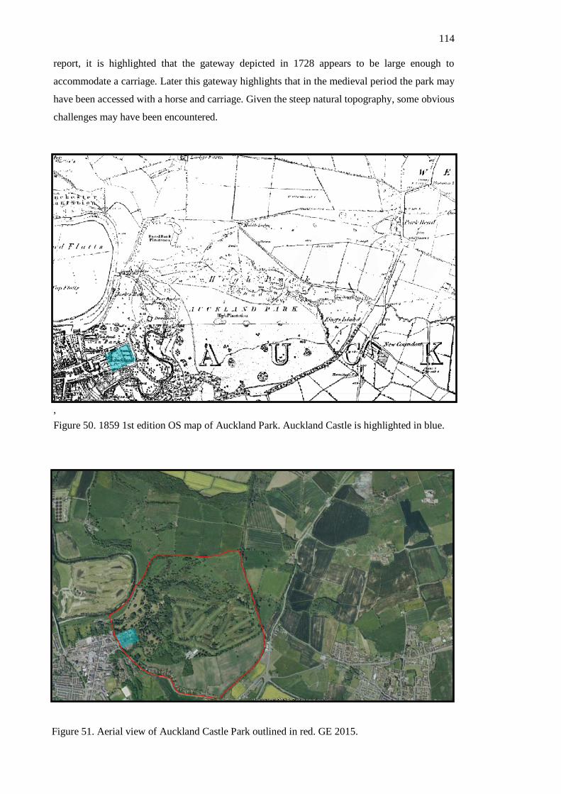
114
report, it is highlighted that the gateway depicted in 1728 appears to be large enough to
accommodate a carriage. Later this gateway highlights that in the medieval period the park may
have been accessed with a horse and carriage. Given the steep natural topography, some obvious
challenges may have been encountered.
,
Figure 50. 1859 1st edition OS map of Auckland Park. Auckland Castle is highlighted in blue.
Figure 51. Aerial view of Auckland Castle Park outlined in red. GE 2015.

115
Primarily, two types of animal appear to have been kept in Auckland Park; deer and wild cattle.
The wild cattle appear to have been of significant interest to zoological researchers in the past
and present due to the belief that these cattle descended from ancient urus (Graham 1932).
Leland remarked that Auckland Park had ‘wild bulls and kine’ while Sir William Brereton
descriptively recorded ’20 wild beasts, all white; will not endure your approach, but if they be
enraged or distressed, very violent and furious’ (Gibson 1862: 36). There were many
documented cases of royal parks containing wild white cattle, though Chillingham Park cattle
remain the most famous and well documented herd (Ritvo 1992; Hall 2006). During
excavations at Auckland Castle, many fragments of cattle bone were recovered, though the age
and profile of the cattle is more consistent with these being domesticated than wild (ASUD
2014: 22 (b)). Although the assemblage is not complete enough for a full profile to be
conducted, all the remains suggest they were slaughtered at an ‘economic age for consumption’
(ASUD 2014: 22 (b)). However, it is possible that our understandings of ‘wild’ do not fit this
evidence. While the medieval accounts discuss ‘wild bulls’, we must remember that they were
contained with a park and likely managed. In this way, ‘hunting’ may have occurred on an
organised scale of economically viable stock. Further faunal remains revealed other hunted
species, notably deer, fowl and fish (ASUD 2014: 22 (b)). The River Gaunless ran through
Auckland Park, probably accounting for the source of the fish and some of the fowl. Deer bones
recovered are of the red deer species which likely inhabited the park in the medieval period.
Reports of restocking Auckland Park in the 17th century, suggest that the animals disappeared in
the Interregnum period. Today fallow deer have been reintroduced to Auckland Park and have
no hereditary connection with the medieval livestock. The wild, white cattle also disappeared
and there was no attempt to reintroduce this breed.
Crayke Park
In contrast to Auckland Park, not much is known about the park surrounding Crayke Castle. A
park appears to have been active at Crayke from the 13th century. On November 8th 1229 the
King granted the bishop a 140ft deer-leap to Crayke (Page 1923: 119). This is unusual as only a
few properties nationwide were granted deer-leaps, with even fewer parks adjacent to royal
parks granted them (Steane 2004: 141). Deer-leaps were earthen embankments designed to
encourage deer to run into parks but not to escape them (Steane 2004: 141). Therefore,
archaeologically these are identifiable as large linear earthworks at the boundary of an estate.
Kaner (1993) attempted to reconstruct the park using a mixture of historic and topographic
sources. Kaner cites descriptions made in the 17th century of fields names ‘Crayke Park Fence’
and ‘Crayke Laund’ and their relative location as ‘over the fosse’ to locate the boundaries of the
park in the landscape.
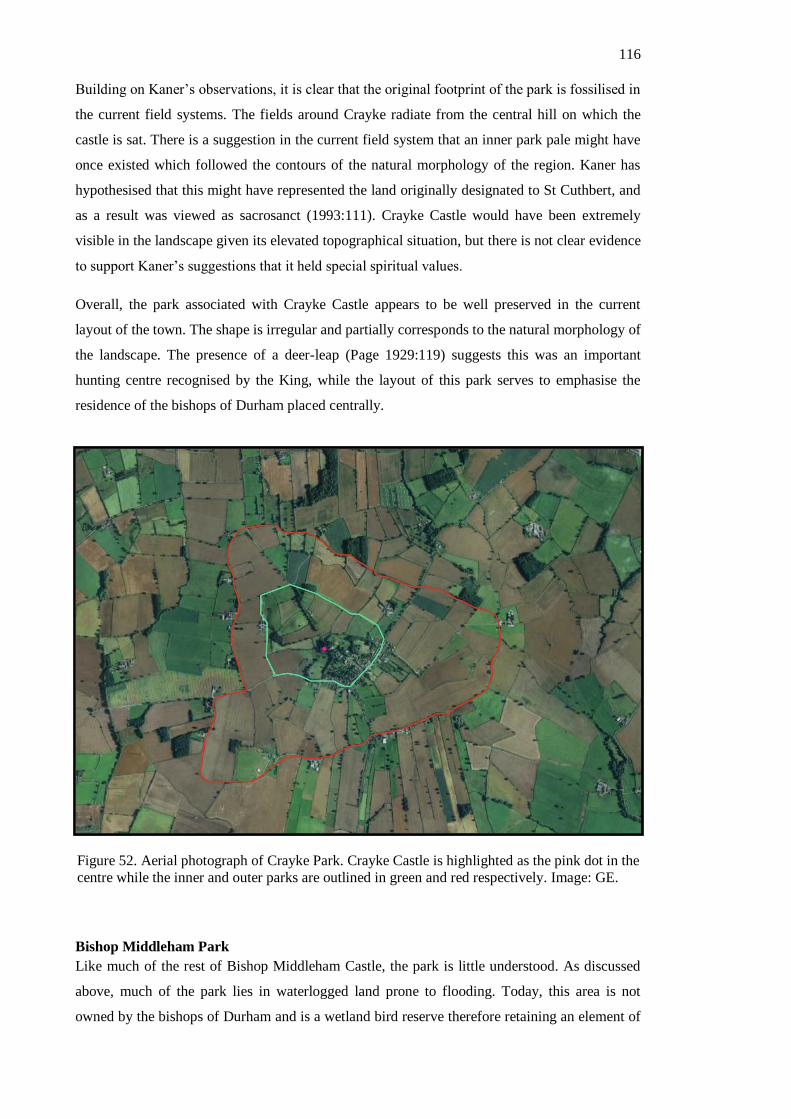
116
Building on Kaner’s observations, it is clear that the original footprint of the park is fossilised in
the current field systems. The fields around Crayke radiate from the central hill on which the
castle is sat. There is a suggestion in the current field system that an inner park pale might have
once existed which followed the contours of the natural morphology of the region. Kaner has
hypothesised that this might have represented the land originally designated to St Cuthbert, and
as a result was viewed as sacrosanct (1993:111). Crayke Castle would have been extremely
visible in the landscape given its elevated topographical situation, but there is not clear evidence
to support Kaner’s suggestions that it held special spiritual values.
Overall, the park associated with Crayke Castle appears to be well preserved in the current
layout of the town. The shape is irregular and partially corresponds to the natural morphology of
the landscape. The presence of a deer-leap (Page 1929:119) suggests this was an important
hunting centre recognised by the King, while the layout of this park serves to emphasise the
residence of the bishops of Durham placed centrally.
Bishop Middleham Park
Like much of the rest of Bishop Middleham Castle, the park is little understood. As discussed
above, much of the park lies in waterlogged land prone to flooding. Today, this area is not
owned by the bishops of Durham and is a wetland bird reserve therefore retaining an element of
Figure 52. Aerial photograph of Crayke Park. Crayke Castle is highlighted as the pink dot in the
centre while the inner and outer parks are outlined in green and red respectively. Image: GE.

117
its former use. Aside from a water treatment centre built within the park boundaries, the rest of
the park has not been built upon. This has left the original boundary of the park keenly visible in
the landscape. In some parts the original walling exists, though it is clear from observation of
the masonry that in parts this has been rebuilt in post-medieval times. The park enclosure is
therefore broadly rectilinear in shape, with the castle plateau completing the northern edge.
Primarily, Bishop Middleham Park comprises two distinct areas and functions; a swannery and
fishponds. Bishop Middleham’s association to the practice of keeping swans can be dated back
to the 14th century. In 1313 Bishop Kellaw received two swans at Bishop Middleham (Hardy
1873: 480). Unfortunately, this report does not elaborate on this fact, and does not indicate
whether or not these swans were kept in Bishop Middleham and whether they were kept
ornamentally or for food. Bailiff’s accounts from 1474-5 document the income from Bishop
Middleham Park include the rent of a dovecot, some properties, hay and swans from the carr
land (Durham University Bishop Middleham Bailiwick Accounts 1413-98. CCB/73/1 –
CCB73/15). This source therefore suggests that the park was used for many functions, with the
naturally waterlogged places used for the keeping of swans. Additionally, this account records
that in one year a swan and six cygnets were killed by poachers (Durham University Bishop
Middleham Bailiwick Accounts 1413-98. CCB/73/1 – CCB73/15).
Immediately beneath the castle plateau are the earthwork remains of medieval fishponds. The
southernmost fish pond is particularly well preserved as a rectilinear depression with raised
earthwork causeways either side. The westernmost fishpond is not as well defined, but can still
Figure 53. Aerial photograph of Bishop Middleham Castle and Park. The park has been outlined in red with areas of
existing park walling highlighted. (Image: GE 2015)

118
be identified as a fishpond. Eating fish on a Friday was a medieval ecclesiastical custom
practiced by bishops and religious people (Frantzen 2014: 235). As a result, the presence of fish
ponds alludes to specificities of an ecclesiastical
Darlington Manor Park
Because of the rapid period of urbanisation in Darlington resulting from the Industrial
Revolution, much of Darlington Manor Park has been built over after Darlington Manor was
sold by the see of Durham in the 19th century. In contrast to other residences owned by the
bishops of Durham, Darlington stayed in their position until the 19th century with the park
largely intact. Images from this period show Darlington Park before it was built over in the 19th
century, offering some semblance of the nature of the park and the views it held. This park was
divided into two parts: the high park and the low parks. These began on the south side of the
river, opposite to Darlington Manor. Therefore, from Darlington Manor, views would have
stretched across the river toward the parks on the other side. The parks had a gradual slope
leading toward the river meaning that the view from Darlington Manor would have shown
episcopal parkland to the horizon. In addition, Darlington Manor would have been a focal point
in the landscape from the manor. Today, the footprint of the park has been fossilised in the town
plan with Parkgate Road positioned along the dividing line between High and Low Parks.
Figure 54. Map edited to showing the high and low parks of the bishops of
Durham still fossilised in the mid-19th century landscape. (OS 1st Edition:
1857).
119
Animal remains recovered in recent archaeological excavations revealed high quantities of bone
and wetland bird remains alongside other typical domestic animal bone assemblages. Notably,
fragmentary parts of a crane and heron were recovered (ASUD 2014: 13). This assemblage of
animal bones might indicate that horses were kept or reared in the park. In addition, the high
levels of bird bones (including the crane bones) might be indicative of the bishops making use
of the river and wetland landscape for hunting and falconry. Herons were a popularly hunted
bird in medieval Britain due to the use of sparrow hawks considered a ‘noble sport’ (Oggins
2004: 16). Therefore, it seems likely that Darlington Park was used as a venue for hunting of
wetland birds and falconry before it was let out for grazing in the Tudor period (Chapman
1975:8).
In addition, unusually high levels of horse bones were recovered, including those of infant foals
and adult horses (ASUD 2014: 12). This assemblage of animal remains further hints at its
possible medieval use as a horse breeding centre, or for the knackering of horses to be used as
fodder for hunting dogs. This would be logical given its commutable distance from major
hunting centres associated with the Forests of Weardale. Overall, this evidence strongly
suggests that Darlington Manor Park held a pivotal role in the wider hunting scene occurring
throughout the residences of the Bishop’s of Durham.
Stanhope Park
These two parks, associated respectively with Westgate Castle and Chapel Walls, will be
considered together as both parks fell within the Forest of Weardale.. The Forest of Weardale
was the permanent hunting ground of the bishops of Durham, and was used annually for the
‘Great Chase’. The ‘Great Chase’ saw the bishops of Durham descend into the forests of
Weardale, to hunt large game alongside elites and nobles from across the bishopric. Hutchinson
(1823: 618) cites the case of the noble William of Little Ushworth attending the Great Chase
repleat with two greyhounds. This was an indulgance of the privileged and important display of
social order and military might (Almond 2003:29-38). Because of the ritual and importance
surrounding this event, no permanent settlement was allowed to exist within the Forest of
Weardale, traditionally wooden buildings were erected annually within the forest to provide
temporary accommodation (Austin 1982: 11-71). The event required exceptional manpower and
resources and is referenced extensively in the Boldon Book (Austin 1982: 11-71).
Stanhope Park is not emparked until c.1250, which is later than other parks recorded in this
chapter. The park covered an area of around seven square miles and is recorded to have been
stocked with fallow deer which were smaller and easier to hunt than larger red or roe deer
(Randerson and Gidney 2011). In so doing, the bishops created a more accessible park to hunt
in. Westgate Castle discussed in Chapter Four formed the westernmost gateway into this park
(ASUD 2014). It is likely therefore, that with the emparking, a more permanent and comfortable
residence was subsequently built to accommodate the bishop. In addition, it has been suggested
120
that settlement in Upper Weardale and increased mining activity, together with the declining
popularity of hunting led the bishops to create a smaller park (ASUD 2014: 5). Significantly, the
annual hunting parties were disbanded by 1442, and the building was latterly leased out (Drury
1987: 72-77). Taken together, the strong textual evidence indicates the unique and specific role
Stanhope Park and residence played in the wider network of episcopal residences.
Stockton Park
There is strong evidence that Stockton Castle had an attached park, though very little textual or
physical evidence relating to it survives. The most descriptive source is a Parliamentary Survey
of the estate from 1647, prior to its destruction by parliamentary order (Page 1928). This survey
describes the ruinous state of the land at this time, with the moat filled in and the park
disimparked. Interestingly, in its description of the landholdings, an orchard and ‘Smithy Hill’
were both within the moated enclosure. Other parts of the park including meadows and fields
held as demesnes fell outside the moated enclosure. In total the extent of the land held as a park
amounted to 370 acres. This description is particularly illuminating as it provides an indication
that the park was complicatedly ordered and divided by the moat.
Unfortunately, any trace of the castle layout in the current plan Stockton-on-Tees is not
possible. Unlike at Darlington where the residence and its park continued in use into the 19th
century, the 17th century demolition and disimparkment of Stockton Castle and Park (Page
1928) mean that the layout of it the park was never reflected in the landscape. Today, Stockton-
on-Tees is a heavily urbanised town which obscures any remaining artificial earthworks.
Compounding this issue, the moat around Stockton Castle was infilled before 1647 (Page 1928),
resulting in no physical trace remaining in the layout of the town. Therefore, due to the
extensive development on the site, any traditional archaeological prospection methods would be
ineffective.
Discussion – Designed, productive or opportunistic landscapes?
So far this chapter has examined the landscapes of the bishops of Durham from two different
perspectives: natural topography and productive, managed land. When viewed independently
this evidence highlights some of the motivations behind the decision to develop particular
aspects of the landscapes and the effect of doing so. When viewed together however, this
evidence can provide better insights into the role these landscapes played alongside the
residences in episcopacy.
The most striking observation from this research is that the landscapes associated with the
residences of the bishops of Durham served a multitude of different roles. Some parks were
used productively to produce a regular supply of food as at Bishop Middleham while others
appear to have functioned more reasonably as pleasure grounds (i.e Auckland Castle), while
others provided valuable resources as at Darlington Park through the possible breeding and
121
raising of horses in the parkland. Individually, this evidence reveals that each park held a
specific role, and when viewed alongside one another, the residences of the bishops of Durham
appeared to have interacted cohesively as parts within a wider network. In this way, the parks
associated with the residences of the bishops of Durham hold an important role in the way we
view the residences.
Also discussed was the natural topography of the regions and the impact the observable trends
displayed across residences. The majority of residences seem to have been placed in either
watery or elevated positions, with the most highly frequented sites sharing an unmistakably
similar natural aesthetic. Although it is hard to draw any substantial conclusions from this, it is
clear that through the decision to place sites in areas with water and hills, the bishops were
effectively fostering a particular aesthetic.
The visual effect of landscapes is an idea that has been explored extensively in relation to
‘designed’ landscapes. James and Gerrard (2007) highlighted how the convoluted entranceway
into Clarendon Royal Palace took advantage of the vast deer park to manufacture specific
viewsheds of the palace. At Somersham Bishop’s Palace (Taylor 1989), ponds were deliberately
placed in front of the building to create a particular visual aesthetic, even when a more logical
place for the them topographically can be identified elsewhere. In both these examples, the
landscapes appear to be designed to emphasise the importance and position of the landowner. In
every aspect of these landscapes, the views were crafted to accentuate the wealth and prestige of
the owner. The concept of ‘designed’ landscapes similar in nature to those portrayed at the
above examples can be identified in Durham. For example, the entranceway was situated into
Auckland Park so as to frame views over the park while entering the complex. Therefore,
through the crafting of these landscapes the bishops wealth and power was showcased and they
were ultimately aggrandised.
Liddiard and Williamson (2008) have challenged whether these landscapes were designed with
the sophistication that many had suggested. They argue that while post-medieval landscapes
certainly employ landscape design as a method of visual aggrandisement, the evidence for this
in medieval contexts is less clear. They instead argue that landscapes projected power through
the display of ‘superior resources of production’ (Liddiard and Williamson 2008: 520). In the
case of the landscapes associated with the residences of the bishops of Durham, there is strong
evidence to suggest that this was a motivating factor also. In each of the examples cited, an
economic resource was showcased in the landscapes. At Bishop Middleham, the swans and fish
that were produced formed the basis of the aquatic landscape while at Crayke Castle the
productive deer park formed the backdrop of this landscape. Therefore, it could be reasonably
argued that through the display of resources of production, these landscapes were altered and
used to transmit deeper suggestions of ownership, wealth and power on a visual level.
122
Therefore, in the case of the Bishops of Durham, their landscapes offer a new perspective on
how we view residences, their role and function. On the one hand they are productive locations
used for food, resources and arenas for hunting. On the other hand, these landscapes served a
deeper symbolic and ideological role as ways to project power and wealth. Fundamentally
however, I argue that these two concepts are intertwined. Through the strategic situation of their
resources in the landscapes and the showcasing of them, the landscapes associated with the
Bishops of Durham acted as visual reminders of the wealth. Coupled with this, the natural
topography of the region served to add a further dimension, emphasising the power of the
bishops through impressive landscape topography. In this way, the landscapes associated with
the residences of the bishops of Durham are integral to our understanding of them.
Conclusion
In conclusion, this chapter examined the natural topography of the residences of the bishops of
Durham alongside an examination of the way these landscapes were used. Through these two
different approaches, an understanding of the role of the landscape in the identity, form and
function of bishop’s residences was achieved. Ultimately, the two different themes are
intimately entwined and offer an interesting and complex interpretation of how we understand
how residences worked and how they were viewed. Liddiard and Williamson’s (2008) notions
of the display of ‘superior resources of production’ is influential this interpretation of the
landscapes associated with the residences of the bishops of Durham.

123
Chapter Six
Discussion
The residences of the bishops of Durham existed as an interconnected body of individual houses
that when viewed as a whole functioned as a physical infrastructure, providing a platform from
which the bishops conducted their duties and articulated their power. In this thesis, three distinct
approaches to understanding episcopal residences have been conducted: how they were used in
conjunction with each other (Chapter Three), how they were used individually and the form
they took (Chapter Four), and lastly how these residences interacted within the wider landscapes
(Chapter Five). Independently, these complimentary approaches show patterns of change and
development on a temporal and geographic basis. When considered together, these approaches
have the capability to offer a deeper understanding of the mechanisms of episcopacy in Durham.
This chapter will draw together the findings from Chapters Three, Four and Five and explore
the impression of episcopacy that is revealed through these findings, and how this interpretation
relates to a broader understanding of bishops and their residences nationwide. The research aims
outlined in Chapter One will form the backdrop for understanding the findings from this study.
Research summary
The clearest observation that can be made from this research is that, while the buildings
remained constant, they had vastly differing roles through the High Medieval Period. At the
beginning of the study period the itineraries of the bishops of Durham revealed how the bishops
assumed predominantly peripatetic lives, using their residences on a broadly equal basis and
moving frequently between them. Generally, the majority of these residences were spread
evenly throughout the see of Durham with a trail of residences continuing southwards toward
London. Routes identified through the itineraries of the bishops of Durham, show specific
journeys made by bishops around the bishopric and down to London which shed light on the
convenient spatial arrangement of residences to as to appropriately facilitate the peripatetic life.
Traces of this lifestyle can be discerned from the form and layout of residences at this time.
Generally, these buildings had a relatively uniform floorplan that was replicated, or closely
approximated, throughout their residences. The overriding impression these discoveries suggest
is that the bishops’ lifestyle was largely peripatetic and there is no obvious allusion to any
preferred residences emerging at this time. Some specialisation did exist at this time in the form
of parks and landscapes, but there is no clear evidence to suggest that these impacted in any
great way the decision to reside at particular sites.

124
Bisecting this study period is a dynamic shift in episcopal practices from the mid-14th century.
After this point, evidence from itineraries and building analysis reveals a perceivable shift in
episcopal practices and habits. The itineraries show that the bishops have adopted a more
sedentary existence, choosing to exist at a more restricted range of sites with fewer journeys
around and through their see. Coeval with this shift in practices is a change in architectural
form. Some residences, notably Durham Castle and Auckland Castle, are extended and
developed to assume radically different forms. These buildings develop on the ubiquitous
central hall with opposing service rooms and bishops’ accommodation, to a far more developed
form featuring additional halls, chambers and private chapels.
Through the application of access analysis to these buildings (Chapter Four), the social
implications of this building evolution have been discerned. Through the construction of
additional rooms and spaces, the bishops’ private spaces are physically segregated from the
communal and service spaces. These changes are symptomatic of a shift in the social role of
bishops; the way that they were viewed and the impression that they sought to project through
their buildings. Johnson argued in the case of secular elite residences, that the proliferation of
new ‘palaces’ was a conscious effort to project power visually in a time of greater social fluidity
as a result of the decline in households (Johnson 1996: 131-140). In effect, without a retinue to
project ones wealth, power and authority, buildings became a new vessel for this social
dialogue. Therefore, the change in movement patterns presented in Chapter Three bares direct
relevance to our understanding of these buildings. In this way, through the study of these two
complimentary approaches a more nuanced impression of the social role of the bishops and the
part buildings played in projecting this.
In Chapter Four the role of the adjoining landscapes of the bishops of Durham were discussed.
The specialised role of these landscapes was discussed, revealing that they each offered a
different reason for the occupation of different sites. The different roles of these parks add to
our notion of these residences acting together within a network, with each residence offering a
slightly different set of specialisms. This idea has particular impact when understanding the
centralisation of activity by bishops at certain residences toward the end of the study period.
The topographic similarities of the sites chosen as primary residences might offer an
explanation for their location and additionally serves as an extension of the built environment,
serving as a method of aggrandisement. In addition, the cultivated landscape (moats/ponds and
gardens) equally acted in conjunction with the buildings to project the power and wealth of the
bishop.
Therefore, in conclusion the three strands of evidence discussed in this thesis depict a clear
impression of the residences of the bishops of Durham over time, how they were used and how

125
their changing form expressed wider ideas relating to the contemporary social and political
climate.
These findings in the context of national medieval episcopacy
As discussed previously (Chapter One), it is challenging to situate the results of this study
within contemporary literature because, aside from Payne (2003), no other systematic study of
all residences within a singular see has been conducted. The findings from this thesis sit
comfortably within those from Payne’s doctoral research which focussed on the bishoprics of
Bath and Wells, and Salisbury. Firstly, the composition of residences (i.e. a mixture of smaller
houses, ‘palaces’ and London Inns) is consistent with those exhibited at both Bath and Wells
and Salisbury. The bishops of Durham appeared to have held more residences than both those
sees but maintained the same broad makeup of residence type. The bishops of Durham did own
more castles than either of those bishoprics, but this is probably the result of its volatile location
neighbouring the Scottish border.
More specifically, Payne (2003) highlights the same trend for declining itinerancy among the
bishops of Bath and Wells, and Salisbury. As in the case of the bishops of Durham, from the
mid-14th century the bishop’s movements become more restricted, and ultimately fewer
residences were popularly frequented for greater proportions of time (Payne 2003: 208). It can
therefore be suggested that the bishops of Durham were affected by the same influences as at
Bath and Wells, and Salisbury. In Chapter Three the probable reason for this change was cited
to have been the decline in the elite medieval household after Johnson’s observations of the
changing nature of medieval elite houses (Johnson 1996: 135). Therefore, Payne’s (2003)
results alongside the findings from this study suggest that bishops were in this respect no
different from other medieval elites.
Even without detailed studies of individual bishoprics, it is possible to draw these comparisons
with other bishoprics. For example, every bishopric appears to have broadly maintained the
same collection of residences. At all sees, a main palace appears to have formed the focus of
episcopal activity, at least by the end of the study period. Among these, many held the same
basic collection of identifying rooms, such as having large halls, a secondary hall, a large
chamber and private chapels. Comparable examples to the palaces at Durham include the
archbishop’s palace at Canterbury (Rady et al 1991), Lincoln (Faulkner 1974) and Wolvesey
Palace (Biddle 1972). At these sites, their floorplan share many basic characteristics with
Durham Castle and Auckland Castle. At Wolvesey Palace for example, the earliest floorplan
would have strongly resembled the earliest suggested floorplan at Auckland Castle, with the hall
and adjoining rooms. In subsequent decades, an additional range was added featuring a further
second hall, similar in kind to Durham Castle. Furthermore, this trend extended to palaces from
less wealthy bishoprics. Noticeably, St David’s palace was the see palace for the diocese of St
David’s (Turner 2000) and its floorplan closely resembled the floorplans at Auckland Castle,

126
Howden Manor and Durham Castle. Aside from the unusually located kitchen that was added in
the 14th century, the access analysis for this residence reveals a similar pattern and development
to the palaces of Durham Castle and Auckland Castle. Its arrangement would have initially been
a central hall with adjoining service rooms and bishops spaces that was ultimately improved
upon to encompass a larger bishop’s chamber, accommodation range and private chapel. In
addition, every other bishopric similarly held one London Inn and many had castles alongside
other manors (Thompson 1993: 71-84; Schofield 1995). While Durham held more castles than
other bishoprics, its compilation of different residence types is not untypical of episcopacy
nationwide.
In the light of this evidence therefore, the residences of the bishops of Durham do not appear to
have been distinctly affected by the unique conditions of the palatinate of Durham. While
politically Durham was known to have been unique (see Chapter One), the residences when
compared with other examples nationally are typical of the trends exhibited elsewhere.
Ultimately therefore, the bishops of Durham were affected by the same external influences that
affected other nobles and elites, and their movements and buildings reflected this change.
Analysis of other bishoprics reveals that these changes permeated even the least wealthy and
influential bishoprics.
Points for progression – future research avenue
One of the primary objectives of this research was to provide a synthetic overview of the current
state of knowledge of the episcopal residences of the bishops of Durham (see. Chapter One). In
so doing, a number of knowledge gaps and potential areas for future research were identified.
This section will outline these key findings.
1) There is potential for considerable future
research at Bishop Middleham Castle. This site stands out among the residences of the
bishops of Durham because of its striking topographic position, good textual record,
and popularity with bishops and unusually short lifespan. Geophysical and earthwork
evidence reveals considerable well-preserved below-ground deposits that have as yet
not been examined archaeologically. Further geophysical examination utilising the
combined methods of electrical resistivity and magnetometry might yield the best
results. Additionally, excavation of the deposits would likely reveal significant finds,
especially relating to the parkland and wider landscape. The excavations at Darlington
and Bishop Auckland show the considerable potential for recovering finds relating to
hunting practices and land management. In addition, the waterlogged landscape might
provide good potential for the recovery of well-preserved organic material. Currently
the site is not developed upon which would assist future examination.
127
2) Similarly, Crayke Castle is an excellent
contender for future research for similar reasons. Although some archaeological work
has been conducted (e.g. Dennison 2004), there is still more that could be done. There is
strong evidence that below-ground deposits relating to the ‘Old Hall’ might exist, and
recovery of these would help clarify the date of the ‘New Tower’. In addition, recovery
of organic material relating to the park would improve knowledge of that. Crayke Castle
as an excellent textual record, so recovery of material culture relating to the medieval
phases of occupation would improve our understanding of the site.
3) The creation of a complete itinerary of the
bishops of Durham would be an excellent resource to fill in gaps and further test and
strengthen theories proposed in this study. This thesis adopted a primarily
archaeological view and therefore, only selection of registers were analysed to reveal
broad trends and patterns. There are more registers currently unanalysed and compiled
together with substantial amounts of unpublished records. A more detailed examination
of these would likely add to our knowledge of these residences and their uses and roles.
Conclusion
Ultimately, the evidence discussed through Chapters Three, Four and Five present a complex
picture of how episcopal residences were used. In specific response to the research aims
outlined in Chapter One, the following was achieved. Through the synthesis and comparison of
some episcopal itineraries, archaeological and historical data relating to the residence buildings
and their associated landscapes some key questions were answered. Firstly, the residences of the
bishops of Durham had individual roles and specialisms borne from the uses of their landscapes.
Contrastingly, the residences also existed within a wider network, situated at convenient
locations for traversing the see of Durham and travelling south to London. In this way, the
residences of the bishops of Durham held a dual role. This role changed over time according to
the changing social atmosphere of the High Medieval Period and this thesis has proven that
through the analysis of their forms, episcopal residences are effective gauges of this. Ultimately
however, these changes displayed through the residences of the bishops of Durham do not
reveal any particular trends unique to them having held Palatinate status. As a whole, the
residences of the Bishops of Durham compliment current knowledge and ideas in the field of
bishops’ residences. Nevertheless, this study is one of the only of its kind, and with further
projects aimed at understanding the relationship between both palaces and smaller manors, the
findings from this thesis could be further tested and extended.
This thesis proves that through the study of only one site, an incomplete picture of the role of
bishop’s residences in the wider episcopal sphere is produced. Only by viewing these residences
as a whole can a meaningful and holistic understanding of these places be gained. This research
128
showed how these buildings existed as parts within a bigger network with each providing a
unique specialism while also providing an effective infrastructure from which the peripatetic life
could be conducted. In addition, this research has shown how these buildings are effective
gauges of social and political change, as their changing form and occupational patterns are
indicative of much wider themes and concepts relating to the changing nature of medieval
society.

129
Appendix One
The Itineraries of the Bishops of Durham
The Itinerary of Bishop Richard Poore (1229-1236) based on actum
compiled and published by M.G. Snape, 2002.
1229 September 24th Durham
September 28th Northallerton
September 29th Northallerton
October 13th Westminster
1230 September 24th Durham
November 28th London
December 27th Durham
1231 December 9th Bishop Auckland
1232 March 10th Bishop Middleham
1233 April 18th Tarrant
July 31st Durham
1234 March 4th Bishop Auckland
August 20th Fulham
1235 April 9th Tarrant
July 8th London
July 18th Stanwell
August 13th Tarrant
November 3rd Fenwick
November 22nd Durham
December 7th Bishop Auckland
December 13th Bishop Auckland
1236 July 8th Easington

130
The Itinerary of Bishop Nicholas Farnham (1241-1249) based on
actum compiled and published by P. Hoskin, 2005.
1241 January 24th - May 24th Aldenham
September 28th Bishop Auckland
1242 October 3rd Stockton
1243 March 3rd Bishop Middleham
April 2nd Bishop Middleham
1244 May 16th Darlington
September 18th Bishop Middleham
October 27th Northallerton
1245 April 20th Midhurst
1246 March 15th Slindon
1247 July 17th Darlington
1248 March 28th Darlington
June 24th Bishop Middleham
August 10th Stockton
September 3rd Darlington
December 2nd Bishop Auckland
1249 January 28th Bishop Middleham
January 30th Kepier
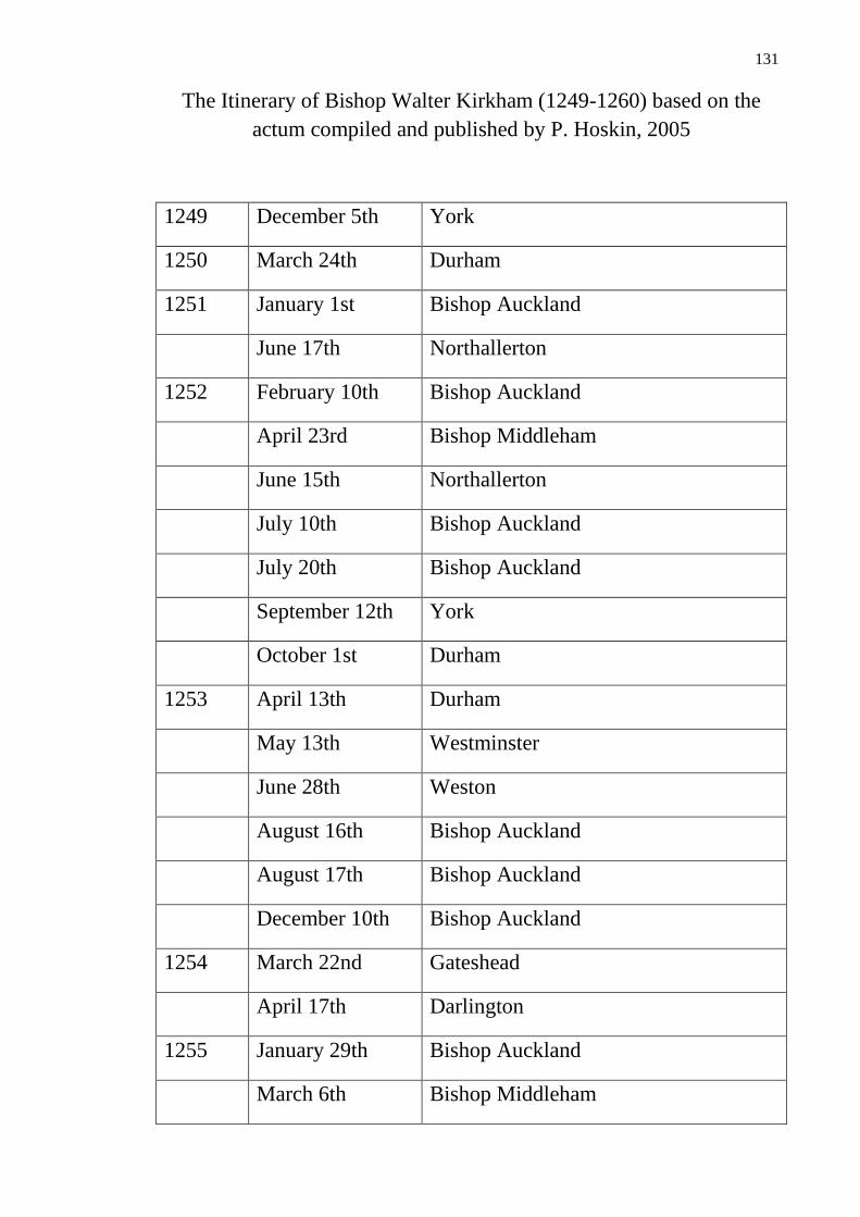
131
The Itinerary of Bishop Walter Kirkham (1249-1260) based on the
actum compiled and published by P. Hoskin, 2005
1249 December 5th York
1250 March 24th Durham
1251 January 1st Bishop Auckland
June 17th Northallerton
1252 February 10th Bishop Auckland
April 23rd Bishop Middleham
June 15th Northallerton
July 10th Bishop Auckland
July 20th Bishop Auckland
September 12th York
October 1st Durham
1253 April 13th Durham
May 13th Westminster
June 28th Weston
August 16th Bishop Auckland
August 17th Bishop Auckland
December 10th Bishop Auckland
1254 March 22nd Gateshead
April 17th Darlington
1255 January 29th Bishop Auckland
March 6th Bishop Middleham
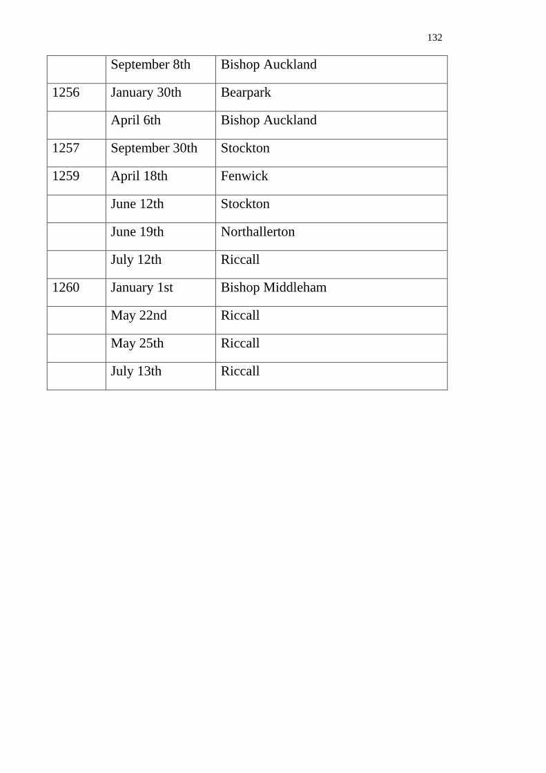
132
September 8th Bishop Auckland
1256 January 30th Bearpark
April 6th Bishop Auckland
1257 September 30th Stockton
1259 April 18th Fenwick
June 12th Stockton
June 19th Northallerton
July 12th Riccall
1260 January 1st Bishop Middleham
May 22nd Riccall
May 25th Riccall
July 13th Riccall

133
The Itinerary of Bishop Robert Stichill (1260-1274) according to the
compiled and published actum by P. Hoskin, 2005
1261 February 13th Lekingfeud
March 3rd Riccall
April 13th Stockton
June 14th Riccall
June 15th Riccall
December 26th Durham
1262 February 12th Bishop Middleham
May 24th Durham
May 25th Bishop Middleham
July 15th Bishop Middleham
October 8th Stockton
November 27th Bishop Middleham
December 13th Lekingfeud
1263 February 18th Bishop Middleham
1264 October 9th Wolsingham
1265 May 23rd Stockton
October 16th Riccall
November 13th Riccall
1266 February 7th Bishop Auckland
June 19th Bishop Middleham
October 19th Stamfordham
October 26th Kenilworth
26th December Howden

134
1267 March 5th Norham
December 25th Durham
1268 January Bishop Auckland
April 9th Greatham
April 23rd London
April 24th London
1269 September 9th Howden
September 10th Howden
1272 February 14th Bishop Auckland
1273 January 8th Durham
January 23rd Durham
March 13th Howden
July 4th Bishop Middleham
1274 February 10th Riccall
April 13th Stockton
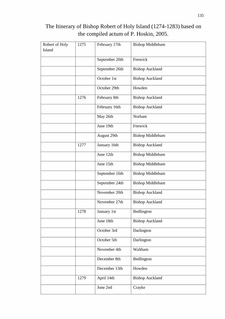
135
The Itinerary of Bishop Robert of Holy Island (1274-1283) based on
the compiled actum of P. Hoskin, 2005.
Robert of Holy
Island
1275 February 17th Bishop Middleham
September 20th Fenwick
September 26th Bishop Auckland
October 1st Bishop Auckland
October 29th Howden
1276 February 8th Bishop Auckland
February 16th Bishop Auckland
May 26th Norham
June 19th Fenwick
August 29th Bishop Middleham
1277 January 16th Bishop Auckland
June 12th Bishop Middleham
June 15th Bishop Middleham
September 16th Bishop Middleham
September 24th Bishop Middleham
November 20th Bishop Auckland
November 27th Bishop Auckland
1278 January 1st Bedlington
June 18th Bishop Auckland
October 3rd Darlington
October 5th Darlington
November 4th Waltham
December 8th Bedlington
December 13th Howden
1279 April 14th Bishop Auckland
June 2nd Crayke

136
August 1st Durham
August 16th Wolsingham
September 8th Northallerton
December 7th Wolsingham
1280 March 28th Fenwick
April 29th Bishop Auckland
May 8th Stockton
1281 April 3rd Norham
April 4th Norham
April 17th Wolsingham
June 15th Halton
1283 January 31st Bishop Middleham
February 24th Durham
May 14th Bishop Middleham
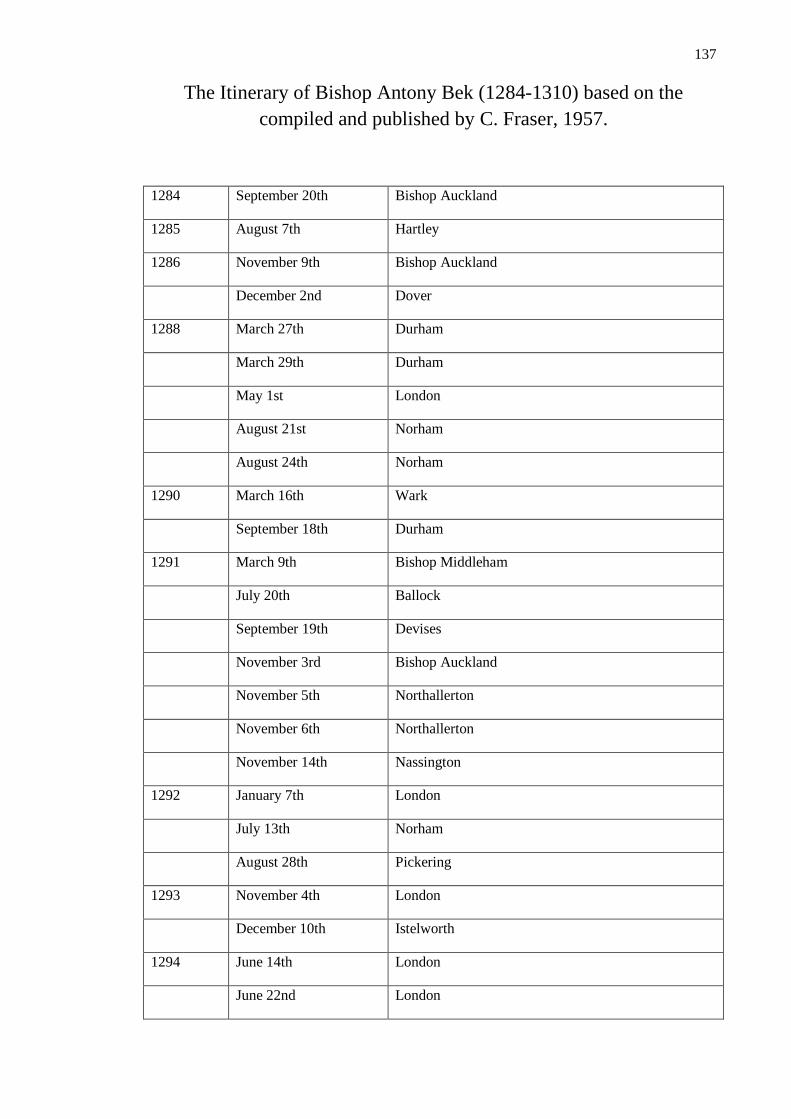
137
The Itinerary of Bishop Antony Bek (1284-1310) based on the
compiled and published by C. Fraser, 1957.
1284 September 20th Bishop Auckland
1285 August 7th Hartley
1286 November 9th Bishop Auckland
December 2nd Dover
1288 March 27th Durham
March 29th Durham
May 1st London
August 21st Norham
August 24th Norham
1290 March 16th Wark
September 18th Durham
1291 March 9th Bishop Middleham
July 20th Ballock
September 19th Devises
November 3rd Bishop Auckland
November 5th Northallerton
November 6th Northallerton
November 14th Nassington
1292 January 7th London
July 13th Norham
August 28th Pickering
1293 November 4th London
December 10th Istelworth
1294 June 14th London
June 22nd London

138
November 1st London
1295 April 10th Chester
December 29th Bishop Auckland
1297 July 19th Westminster
1298 June 17th Bishop Auckland
October 26th Northallerton
1300 April 24th Durham
November 2nd Bishop Auckland
November 6th Stivelingflet
November 30th Riccall
1301 April 13th Barnard Castle
November 10th Bishop Auckland
December 1st Durham
1303 June 25th Bishop Auckland
August 31st Barnard Castle
September 1st Somerton
1305 June 10th Wolsingham
1306 August 13th Northallerton
1307 July 29th Carlisle
October 2nd Somerton
1308 September 30th Waltham
December 12th Eltham
1309 February 10th Bishop Auckland
March 30th Howden
July 16th Eltham
September 23rd London
September 26th London
October 1st Newnham
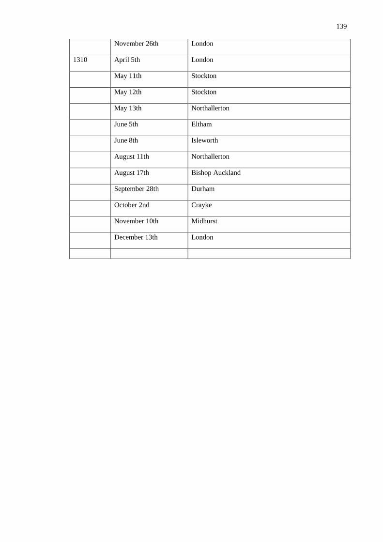
139
November 26th London
1310 April 5th London
May 11th Stockton
May 12th Stockton
May 13th Northallerton
June 5th Eltham
June 8th Isleworth
August 11th Northallerton
August 17th Bishop Auckland
September 28th Durham
October 2nd Crayke
November 10th Midhurst
December 13th London
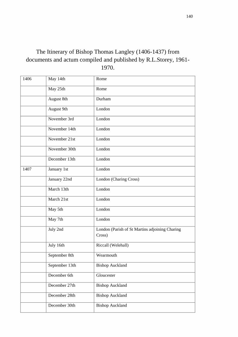
140
The Itinerary of Bishop Thomas Langley (1406-1437) from
documents and actum compiled and published by R.L.Storey, 1961-
1970.
1406 May 14th Rome
May 25th Rome
August 8th Durham
August 9th London
November 3rd London
November 14th London
November 21st London
November 30th London
December 13th London
1407 January 1st London
January 22nd London (Charing Cross)
March 13th London
March 21st London
May 5th London
May 7th London
July 2nd London (Parish of St Martins adjoining Charing
Cross)
July 16th Riccall (Welehall)
September 8th Wearmouth
September 13th Bishop Auckland
December 6th Gloucester
December 27th Bishop Auckland
December 28th Bishop Auckland
December 30th Bishop Auckland
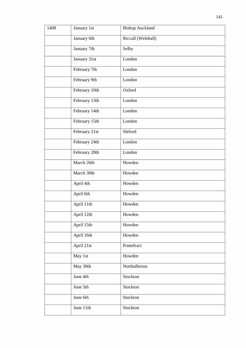
141
1408 January 1st Bishop Auckland
January 6th Riccall (Welehall)
January 7th Selby
January 31st London
February 7th London
February 9th London
February 10th Oxford
February 13th London
February 14th London
February 15th London
February 21st Sleford
February 24th London
February 28th London
March 26th Howden
March 30th Howden
April 4th Howden
April 6th Howden
April 11th Howden
April 12th Howden
April 15th Howden
April 16th Howden
April 21st Pontefract
May 1st Howden
May 30th Northallerton
June 4th Stockton
June 5th Stockton
June 6th Stockton
June 11th Stockton
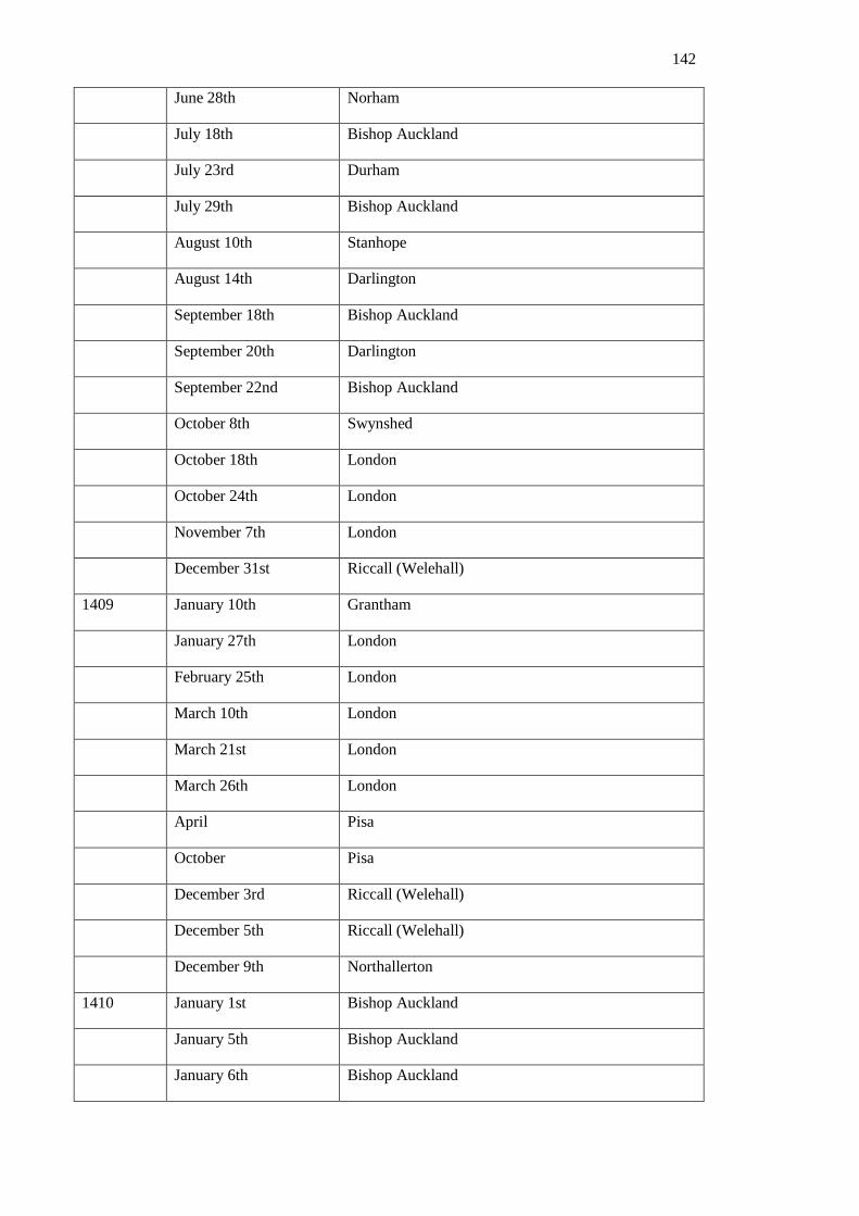
142
June 28th Norham
July 18th Bishop Auckland
July 23rd Durham
July 29th Bishop Auckland
August 10th Stanhope
August 14th Darlington
September 18th Bishop Auckland
September 20th Darlington
September 22nd Bishop Auckland
October 8th Swynshed
October 18th London
October 24th London
November 7th London
December 31st Riccall (Welehall)
1409 January 10th Grantham
January 27th London
February 25th London
March 10th London
March 21st London
March 26th London
April Pisa
October Pisa
December 3rd Riccall (Welehall)
December 5th Riccall (Welehall)
December 9th Northallerton
1410 January 1st Bishop Auckland
January 5th Bishop Auckland
January 6th Bishop Auckland

143
January 9th Durham
February 12th London
February 13th London
February 20th London
March 8th London
April 25th London
May 5th London
June 13th London
Jun 14th London
August 15th Bishop Auckland
August 21st Jarrow
August 27th Bishop Auckland
September 8th Bishop Auckland
September 18th Bishop Auckland
September 20th Bishop Auckland
September 24th Bishop Auckland
September 29th Crayke
October 5th Cawood
October 6th Riccall (Welehall)
October 20th London
October 24th London
December 1st Leicester
December 2nd Leicester
December 7th Riccall (Welehall)
December 8th Riccall (Welehall)
December 25th Bishop Auckland
1411 January 2nd Bishop Auckland
January 5th Bishop Auckland

144
January 11th Bishop Auckland
January 14th Bishop Auckland
January 24th Bishop Auckland
January 25th Bishop Auckland
January 29th Crayke
January 30th Shirrefhoton
March 9th London
March 20th London
April 27th Howden
June 17th Bishop Auckland
June 19th Bishop Auckland
June 21st Bishop Auckland
June 22nd Bishop Auckland
June 23rd Bishop Auckland
July 2nd Bishop Auckland
July 6th Sherburn Hospital
July 31st Bishop Auckland
August 26th Bishop Auckland
September 1st Bishop Auckland
September 3rd Northallerton
September 20th London
September 28th Oldeford
November 8th London
November 29th London
November 30th London
December 22nd Durham
December 27th Howden
1412 January 12th Bishop Auckland

145
January 14th Bishop Auckland
January 22nd York
January 24th howden
January 28th Howden
February 6th London
February 15th London
March 13th Riccall (Welehall)
March 14th Riccall (Welehall)
March 26th Durham
April 2nd Durham
April 14th Bishop Auckland
April 16th Bishop Auckland
April 18th Bishop Auckland
April 29th Bishop Auckland
May 10th London
May 11th Fulham
May 17th London
July 24th London
August 19th York
August 24th Howden
August 26th Howden
December 4th Bishop Auckland
December 5th Bishop Auckland
December 10th Bishop Auckland
December 14th Bishop Auckland
December 17th Bishop Auckland
December 19th Bishop Auckland
December 20th Bishop Auckland
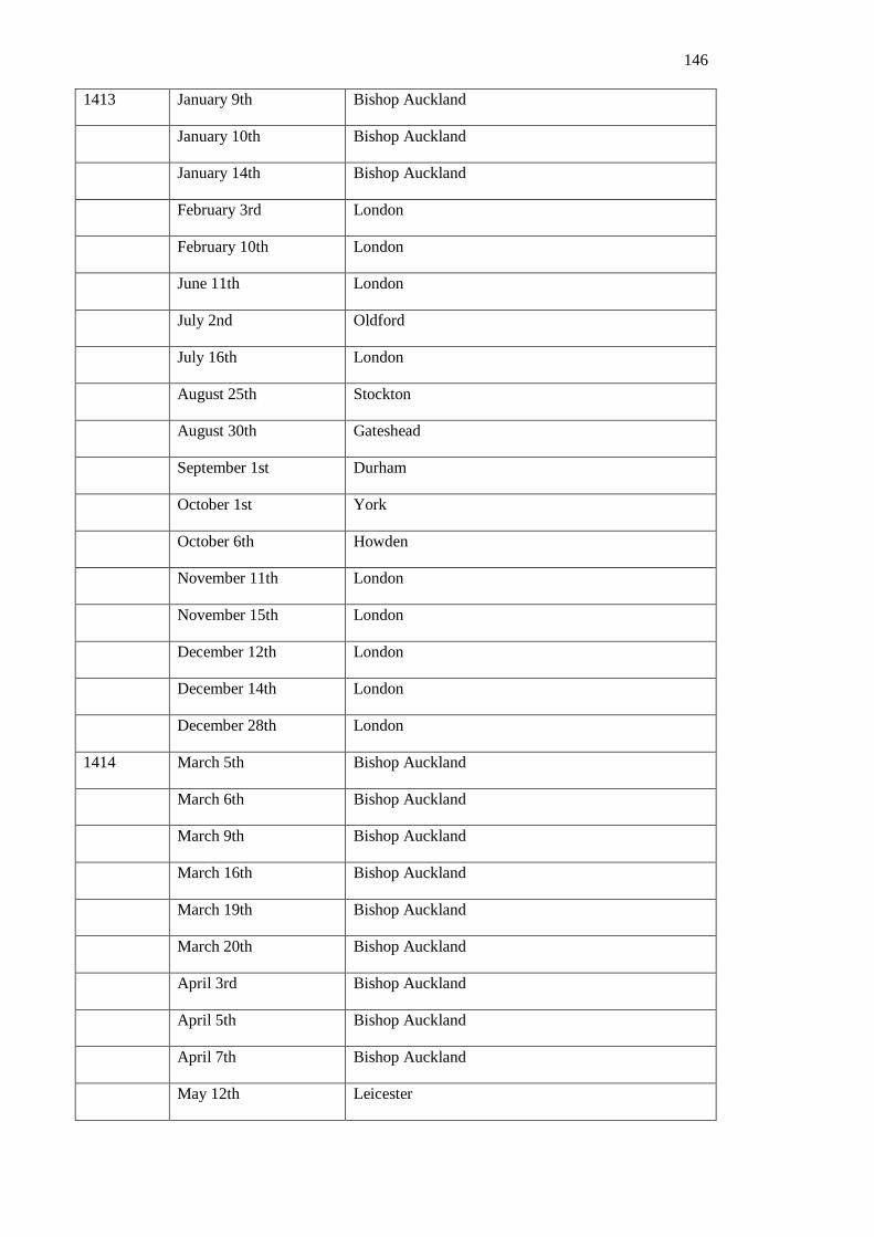
146
1413 January 9th Bishop Auckland
January 10th Bishop Auckland
January 14th Bishop Auckland
February 3rd London
February 10th London
June 11th London
July 2nd Oldford
July 16th London
August 25th Stockton
August 30th Gateshead
September 1st Durham
October 1st York
October 6th Howden
November 11th London
November 15th London
December 12th London
December 14th London
December 28th London
1414 March 5th Bishop Auckland
March 6th Bishop Auckland
March 9th Bishop Auckland
March 16th Bishop Auckland
March 19th Bishop Auckland
March 20th Bishop Auckland
April 3rd Bishop Auckland
April 5th Bishop Auckland
April 7th Bishop Auckland
May 12th Leicester
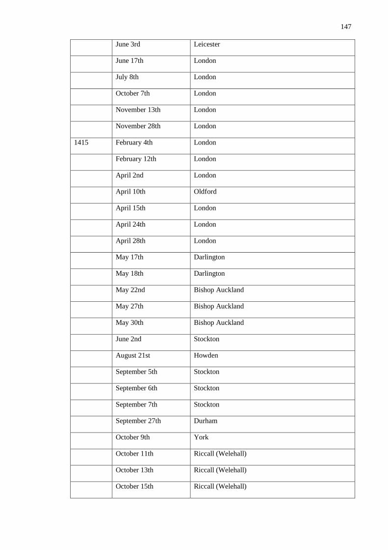
147
June 3rd Leicester
June 17th London
July 8th London
October 7th London
November 13th London
November 28th London
1415 February 4th London
February 12th London
April 2nd London
April 10th Oldford
April 15th London
April 24th London
April 28th London
May 17th Darlington
May 18th Darlington
May 22nd Bishop Auckland
May 27th Bishop Auckland
May 30th Bishop Auckland
June 2nd Stockton
August 21st Howden
September 5th Stockton
September 6th Stockton
September 7th Stockton
September 27th Durham
October 9th York
October 11th Riccall (Welehall)
October 13th Riccall (Welehall)
October 15th Riccall (Welehall)
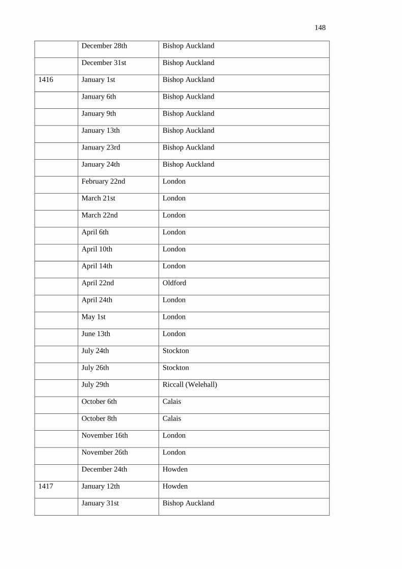
148
December 28th Bishop Auckland
December 31st Bishop Auckland
1416 January 1st Bishop Auckland
January 6th Bishop Auckland
January 9th Bishop Auckland
January 13th Bishop Auckland
January 23rd Bishop Auckland
January 24th Bishop Auckland
February 22nd London
March 21st London
March 22nd London
April 6th London
April 10th London
April 14th London
April 22nd Oldford
April 24th London
May 1st London
June 13th London
July 24th Stockton
July 26th Stockton
July 29th Riccall (Welehall)
October 6th Calais
October 8th Calais
November 16th London
November 26th London
December 24th Howden
1417 January 12th Howden
January 31st Bishop Auckland

149
February 2nd Bishop Auckland
February 6th Bishop Auckland
February 12th Bishop Auckland
February 14th Bishop Auckland
February 19th Bishop Auckland
February 20th Bishop Auckland
February 21st Bishop Auckland
February 22nd Bishop Auckland
February 23rd Bishop Auckland
February 28th Bishop Auckland
March 1st Howden
March 10th Howden
March 22nd Huntingdon
April 21sr Oldeford
May 13th London
May 14th Reading
May 20th London
September 29th Oldeford
October 13th London
October 23rd London
October 28th London
October 30th London
November 10th London
November 28th London
December 2nd London
1418 January 4th Asshere
March 19th Oldeford
April 4th London

150
April 5th Oldeford
April 24th London
June 18th London
July 20th Oldeford
August 7th Stockton
August 12th Stockton
September 16th Bishop Auckland
October 16th London
November 4th London
November 20th London
December 3rd London
December 7th London
December 12th London
1419 January 6th London
January 20th London
January 24th London
February 10th London
April 20th Oldeford
June 16th London
September 2nd Oldeford
November 9th London
November 12th London
December 24th Oldeford
1420 January 6th London
February 1st London
February 16th London
May 13th London
December 20th London

151
1421 March 18th Durham
September 2nd Lumley Castle
September 4th Bishop Auckland
September 11th Bishop Auckland
September 12th Bishop Auckland
September 13th Bishop Auckland
October 13th London
1422 January 4th Oldeford
March 27th Oldeford
April 30th Suthwik
May 16th London
May 17th Fermerygardyn
June 3rd London
August 18th Stockton
August 26th Stockton
September 9th Stockton
September 10th Stockton
September 15th Crayke
November 13th London
November 27th London
1423 June 12th London
June 16th London
October 1st Durham
1424 March 10th Huntingdon
March 20th Durham
March 31st Durham
April 5th Bishop Auckland
April 9th Durham

152
July 21st Sutton in Holand
August 29th Newcastle-upon-Tyne
September 11th Bishop Auckland
September 29th Stockton
October 1st Durham
October 20th London
October 25th London
October 28th London
November 24th London
December 11th Hoveden
December 23rd Durham
1425 January 5th Bishop Auckland
January 14th Bishop Auckland
January 18th Bishop Auckland
February 2nd Bishop Auckland
February 9th Bishop Auckland
February 17th Bishop Auckland
February 22nd Bishop Auckland
February 23rd Bishop Auckland
March 6th Bishop Auckland
March 24th Bishop Auckland
April 5th Bishop Auckland
April 7th Bishop Auckland
April 9th Bishop Auckland
April 12th Bishop Auckland
May 3rd London
May 15th London
May 16th London

153
May 17th London
July 1st London
July 30th Howden
August 5th Whitfield
August 20th Berwick
August 27th Bishop Auckland
September 7th Bishop Auckland
September 18th Newcastle-upon-Tyne
September 19th Jarum
September 20th Alnwick
August 1st Salisbury
August 5th Stockton
August 12th Holy Island
August 14th Norham
August 25th Newcastle-upon-Tyne
August 28th Bishop Auckland
August 31st Stockton
October 4th Bishop Auckland
November 6th Stockton
December 4th London
1426 January 31st London
1427 November 8th London
November 9th London
November 11th London
November 12th London
November 20th London
November 27th London
November 28th London
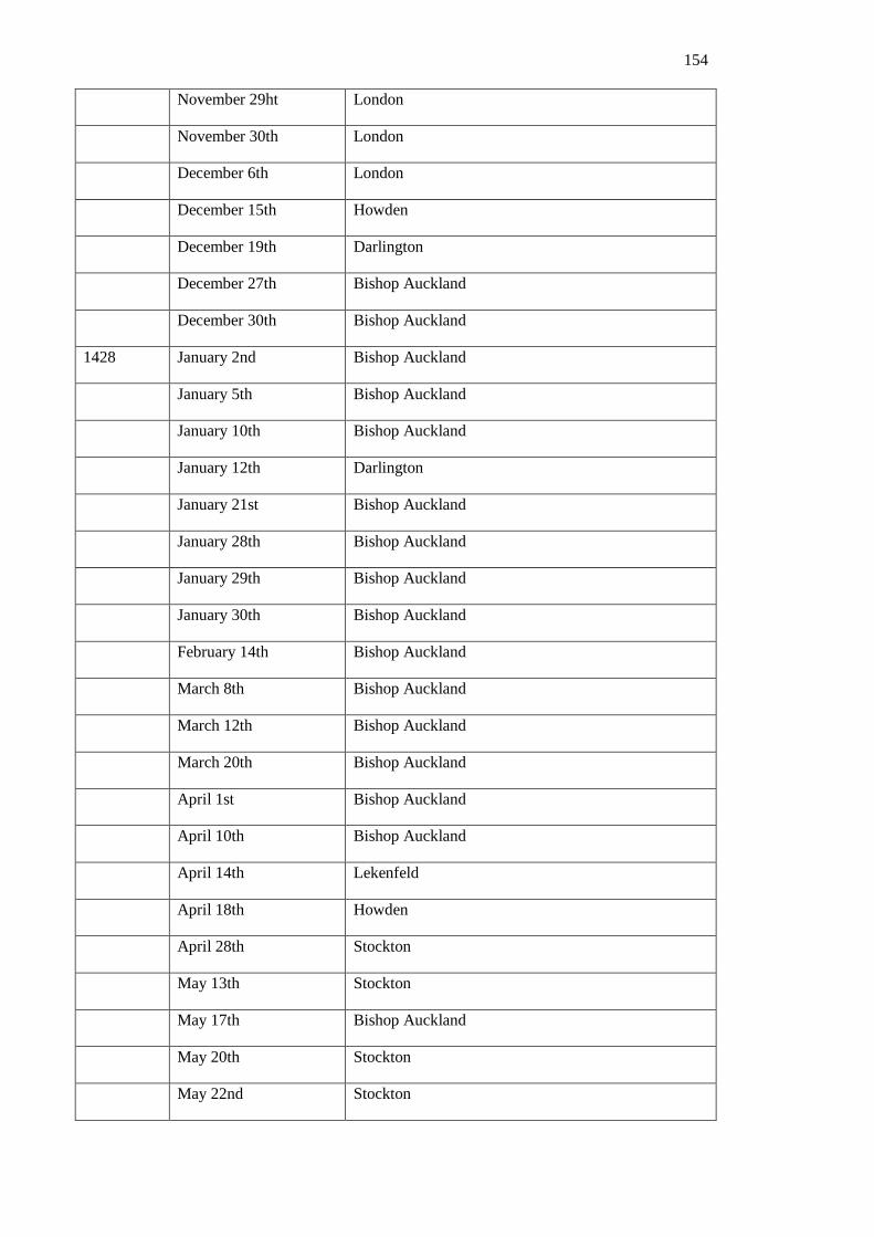
154
November 29ht London
November 30th London
December 6th London
December 15th Howden
December 19th Darlington
December 27th Bishop Auckland
December 30th Bishop Auckland
1428 January 2nd Bishop Auckland
January 5th Bishop Auckland
January 10th Bishop Auckland
January 12th Darlington
January 21st Bishop Auckland
January 28th Bishop Auckland
January 29th Bishop Auckland
January 30th Bishop Auckland
February 14th Bishop Auckland
March 8th Bishop Auckland
March 12th Bishop Auckland
March 20th Bishop Auckland
April 1st Bishop Auckland
April 10th Bishop Auckland
April 14th Lekenfeld
April 18th Howden
April 28th Stockton
May 13th Stockton
May 17th Bishop Auckland
May 20th Stockton
May 22nd Stockton

155
June 20th London
June 21st London
June 22nd London
July 13th London
July 14th London
August 12th Monastry of St Mary, The Virgin
August 14th Monastry of St Mary, The Virgin
August 18th Monastry of St Mary, The Virgin
August 28th Stockton
September 9th Bishop Auckland
September 10th Bishop Auckland
September 11th Bishop Auckland
September 16th Stockton
September 20th Stockton
October 5th Stockton
October 25th Stockton
October 31st Stockton
November 3rd Stockton
November 10th Stockton
November 12th Stockton
November 17th Bishop Auckland
November 19th Bishop Auckland
December 1st Bishop Auckland
December 2nd Bishop Auckland
December 6th Bishop Auckland
December 20th Bishop Auckland
December 22nd Bishop Auckland
December 24th Bishop Auckland
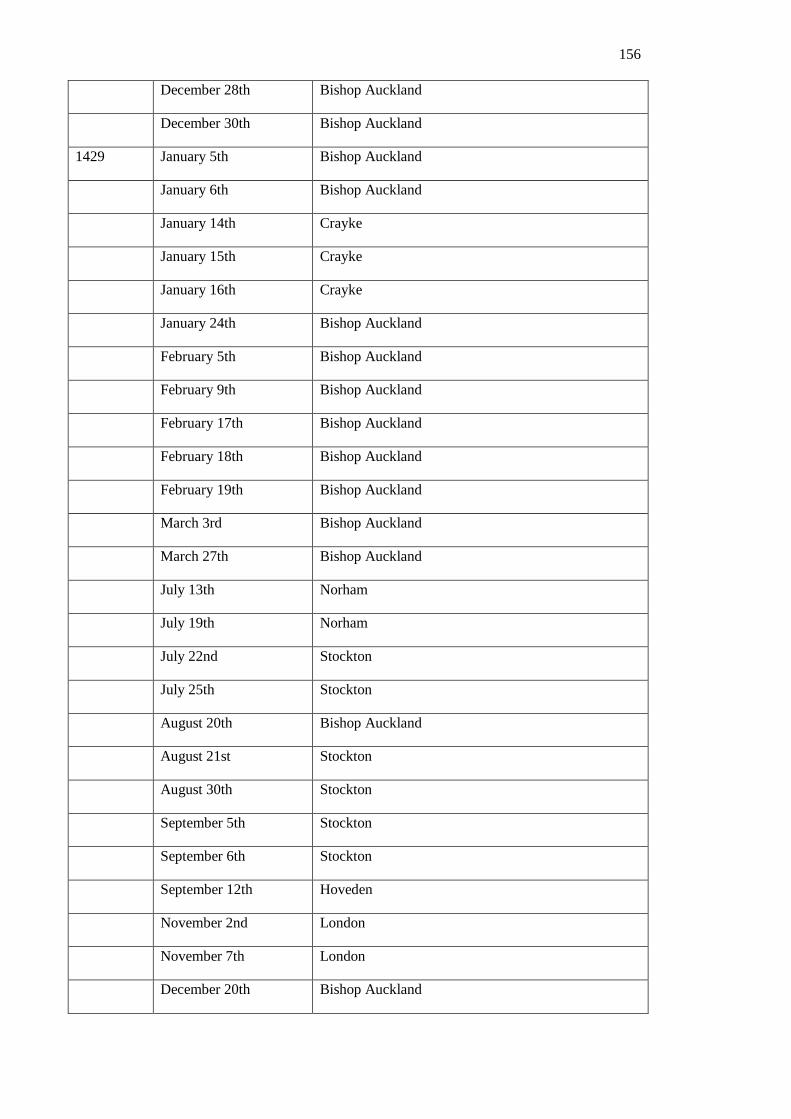
156
December 28th Bishop Auckland
December 30th Bishop Auckland
1429 January 5th Bishop Auckland
January 6th Bishop Auckland
January 14th Crayke
January 15th Crayke
January 16th Crayke
January 24th Bishop Auckland
February 5th Bishop Auckland
February 9th Bishop Auckland
February 17th Bishop Auckland
February 18th Bishop Auckland
February 19th Bishop Auckland
March 3rd Bishop Auckland
March 27th Bishop Auckland
July 13th Norham
July 19th Norham
July 22nd Stockton
July 25th Stockton
August 20th Bishop Auckland
August 21st Stockton
August 30th Stockton
September 5th Stockton
September 6th Stockton
September 12th Hoveden
November 2nd London
November 7th London
December 20th Bishop Auckland

157
December 22nd Bishop Auckland
1430 January 8th Bishop Auckland
January 14th Bishop Auckland
January 16th Bishop Auckland
January 19th Bishop Auckland
January 27th Bishop Auckland
January 28th Bishop Auckland
January 30th Bishop Auckland
February 3rd Bishop Auckland
February 13th Bishop Auckland
February 14th Bishop Auckland
February 20th Bishop Auckland
February 23rd Bishop Auckland
March 1st Bishop Auckland
March 2nd Bishop Auckland
March 3rd Bishop Auckland
March 5th Durham
March 6th Durham
March 11th Durham
April 1st Bishop Auckland
April 15th Bishop Auckland
April 26th Lumley Castle
April 29th Durham
June 10th Bishop Auckland
July 7th Bishop Auckland
July 8th Bishop Auckland
July 12th Bishop Auckland
July 14th Bishop Auckland

158
July 19th Ryton
July 24th Bishop Auckland
july 31st Bishop Auckland
August 1st Darlington
August 14th York
August 25th Bishop Auckland
September 2nd Bishop Auckland
September 3rd Bishop Auckland
September 6th Bishop Auckland
September 16th Bishop Auckland
December 14th Bishop Auckland
December 20th Bishop Auckland
December 23rd Bishop Auckland
December 29th Bishop Auckland
1431 January 2nd Bishop Auckland
January 8th Bishop Auckland
January 14th Howden
January 22nd Howden
February 5th Bishop Auckland
February 11th Bishop Auckland
February 18th Bishop Auckland
February 24th Bishop Auckland
March19th Bishop Auckland
March 20th Bishop Auckland
March28th Bishop Auckland
April 11th Bishop Auckland
April 17th Stockton
April 20th Stockton
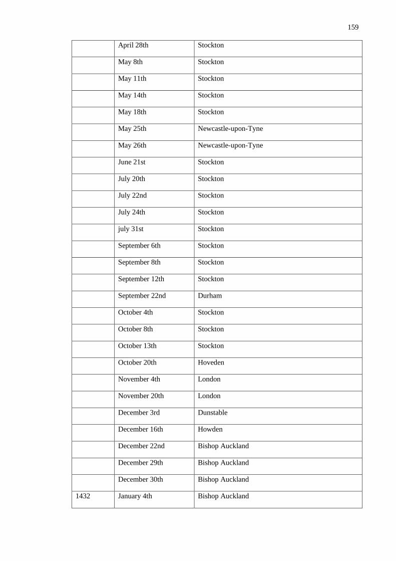
159
April 28th Stockton
May 8th Stockton
May 11th Stockton
May 14th Stockton
May 18th Stockton
May 25th Newcastle-upon-Tyne
May 26th Newcastle-upon-Tyne
June 21st Stockton
July 20th Stockton
July 22nd Stockton
July 24th Stockton
july 31st Stockton
September 6th Stockton
September 8th Stockton
September 12th Stockton
September 22nd Durham
October 4th Stockton
October 8th Stockton
October 13th Stockton
October 20th Hoveden
November 4th London
November 20th London
December 3rd Dunstable
December 16th Howden
December 22nd Bishop Auckland
December 29th Bishop Auckland
December 30th Bishop Auckland
1432 January 4th Bishop Auckland

160
January 13th Bishop Auckland
January 22nd Bishop Auckland
January 24th Bishop Auckland
January 29th Bishop Auckland
January 30th Bishop Auckland
February 22nd Bishop Auckland
February 23rd Bishop Auckland
February 24th Bishop Auckland
February 26th Bishop Auckland
February 28th Bishop Auckland
February 29th Bishop Auckland
March 1st Bishop Auckland
March 6th Bishop Auckland
March 11th Bishop Auckland
March 12th Bishop Auckland
March 15th Bishop Auckland
March 17th Bishop Auckland
March 24th Bishop Auckland
April 2nd Bishop Auckland
April 9th Bishop Auckland
April 12th Bishop Auckland
April 15th Bishop Auckland
April 16th Bishop Auckland
April 23rd Bishop Auckland
May 12th London
May 26th London
August 21st Stockton
August 22nd Stockton

161
September 12th Durham
September 16th Stockton
September 17th Stockton
September 18th Stockton
September 19th Stockton
September 23rd Bishop Auckland
October 1st Crayke
October 4th York
October 27th Stockton
November 5th Bishop Auckland
November 6th Bishop Auckland
November 13th Bishop Auckland
November 16th Bishop Auckland
November 21st Bishop Auckland
November 22nd Bishop Auckland
December 1st Appelby
December 6th Bishop Auckland
December 9th Bishop Auckland
December 12th Bishop Auckland
December 13th Bishop Auckland
December 24th Bishop Auckland
December 28th Bishop Auckland
December 31st Bishop Auckland
1433 February 2nd Bishop Auckland
February 5th Bishop Auckland
February 7th Bishop Auckland
February 12th Bishop Auckland
February 18th Bishop Auckland

162
February 23rd Bishop Auckland
march 13th Bishop Auckland
march 18th Bishop Auckland
March 23rd Bishop Auckland
March 31st Bishop Auckland
April 1st Bishop Auckland
April 3rd Bishop Auckland
April 9th Bishop Auckland
April 11th Bishop Auckland
April 14th Bishop Auckland
April 15th Bishop Auckland
April 18th Crayke
May 8th London
May 12th London
July 24th London
July 27th London
July 31st London
August 12th London
August 31st York
September 11th Stockton
September 20th Stockton
September 21st Stockton
September 23rd Stockton
September 27th Stockton
October 6th Hoveden
October 19th Grantham
November 14th London
November 20th London

163
November 23rd London
December 8th London
1434 January 4th Oldeford
January 5th London
January 7th Oldeford
January 30th London
February 24th London
March 18th Bishop Auckland
April 9th York
April 19th Bishop Auckland
April 20th Bishop Auckland
April 27th Bishop Auckland
April 29th Bishop Auckland
May 1st Bishop Auckland
May 22nd Bishop Auckland
June 4th Stockton
June 5th Stockton
June 14th Stockton
June 15th Stockton
June 30th Stockton
July 19th Middleton
July 27th Stockton
August 21st Durham
August 25th Durham
August 26th Stockton
September 14th Stockton
September 25th Bishop Auckland
October 2nd Crayke

164
November 10th Abendon (Salisbury)
November 26th Hoveden
December 8th Bishop Auckland
December 11th Bishop Auckland
December 13th Bishop Auckland
December 19th Bishop Auckland
December 20th Bishop Auckland
December 27th Bishop Auckland
1435 January 8th Bishop Auckland
January 11th Bishop Auckland
January 27th Bishop Auckland
January 31st Bishop Auckland
February 1st Bishop Auckland
February 4th Bishop Auckland
February 10th Bishop Auckland
February 21st Bishop Auckland
February 22nd Bishop Auckland
February 28th Bishop Auckland
March 7th Bishop Auckland
March 8th Bishop Auckland
March 12th Bishop Auckland
March 21st Bishop Auckland
March 29th Bishop Auckland
April 7th Bishop Auckland
April 8th Bishop Auckland
April 12th Durham
April 20th Bishop Auckland
May 5th Bishop Auckland
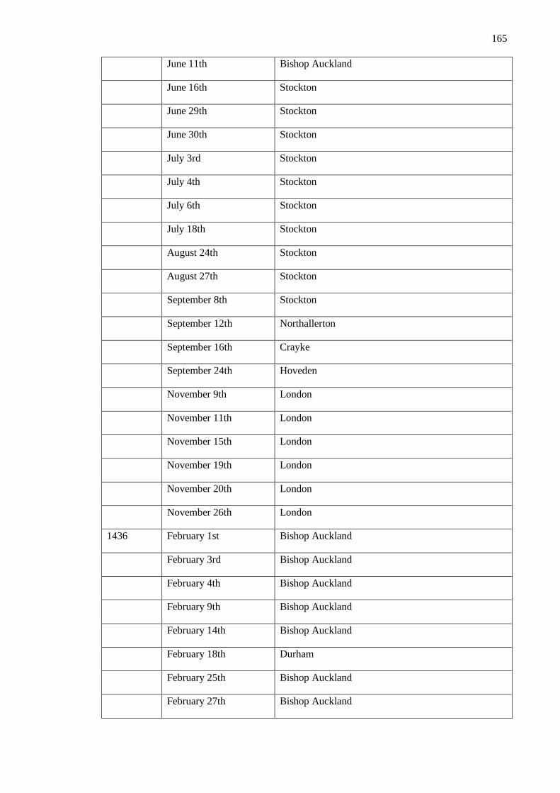
165
June 11th Bishop Auckland
June 16th Stockton
June 29th Stockton
June 30th Stockton
July 3rd Stockton
July 4th Stockton
July 6th Stockton
July 18th Stockton
August 24th Stockton
August 27th Stockton
September 8th Stockton
September 12th Northallerton
September 16th Crayke
September 24th Hoveden
November 9th London
November 11th London
November 15th London
November 19th London
November 20th London
November 26th London
1436 February 1st Bishop Auckland
February 3rd Bishop Auckland
February 4th Bishop Auckland
February 9th Bishop Auckland
February 14th Bishop Auckland
February 18th Durham
February 25th Bishop Auckland
February 27th Bishop Auckland

166
February 28th Durham
March 1st Bishop Auckland
March 3rd Bishop Auckland
March 14th Bishop Auckland
March 20th Bishop Auckland
April 11th Bishop Auckland
April 17th Bishop Auckland
April 18th Bishop Auckland
May 17th Bishop Auckland
May 29th Bishop Auckland
June 5th Darlington
June 9th Crayke
June 25th Bishop Auckland
July 27th Bishop Auckland
August 1st Stockton
August 7th Stockton
August 8th Stockton
August 12th Stockton
August 20th Alnwick
September 10th Stockton
September 12th Heywod
September 14th Stockton
September 23rd Stockton
October 4th Stockton
October 16th Bishop Auckland
October 17th Bishop Auckland
October 19th Bishop Auckland
October 20th Bishop Auckland

167
October 23rd Bishop Auckland
November 1st Bishop Auckland
November 13th Bishop Auckland
November 19th Bishop Auckland
November 20th Bishop Auckland
November 27th Bishop Auckland
November 29th Bishop Auckland
December 1st Bishop Auckland
December 18th Bishop Auckland
December 22nd Bishop Auckland
1437 January 1st Bishop Auckland
January 3rd Bishop Auckland
January 10th Bishop Auckland
January 21st Bishop Auckland
January 23rd Bishop Auckland
January 26th Bishop Auckland
January 27th Bishop Auckland
February 1st Bishop Auckland
February 5th Bishop Auckland
February 10th Bishop Auckland
February 12th Bishop Auckland
February 15th Bishop Auckland
February 16th Bishop Auckland
February 25th Bishop Auckland
March 5th Bishop Auckland
March 12th Bishop Auckland
March 23rd Bishop Auckland
March 27th Bishop Auckland

168
April 1st Bishop Auckland
April 3rd Bishop Auckland
April 5th Bishop Auckland
April 7th Bishop Auckland
April 13th Bishop Auckland
April 15th Bishop Auckland
April16th Bishop Auckland
April 21st Bishop Auckland
April 23rd Bishop Auckland
May 7th Bishop Auckland
May 25th Bishop Auckland
May 31st Alnwick
June 1st Bishop Auckland
June 10th Bishop Auckland
June 12th Bishop Auckland
July 3rd Bishop Auckland
July 4th Bishop Auckland
July 12th Bishop Auckland
July 15th Bishop Auckland
July 17th Bishop Auckland
July 28th Bishop Auckland
August 1st Bishop Auckland
August 19th Bishop Auckland
August 24th Bishop Auckland
August 26th Bishop Auckland
August 28th Bishop Auckland
September 6th Bishop Auckland
September 10th Bishop Auckland

169
September 19th Bishop Auckland
October 1st Bishop Auckland
October 4th Bishop Auckland
October 10th Bishop Auckland
October 22nd Bishop Auckland
October 27th Bishop Auckland
October 31st Bishop Auckland
November 3rd Bishop Auckland
November 10th Bishop Auckland
November 20th Bishop Auckland

170
Bibliography
Aberg, F.A. 1978. Medieval Moated Sites. CBA Research Report. Volume 17.
Aberg, F.A. and Smith, A.N. 1988. Excavations on the castle site, Stockton-on-Tees. In: Manby,
T.G. 1988. (ed). Archaeology in Eastern Yorkshire: Essays in Honour of T.C.M. Brewster FSA.
G.W. Belton Ltd. Gainsborough.
Adams, K. 1984. Excavation and Fieldwork at Crayke. Council for Archaeology: Bulletin of the
C.B.A. Churches Committee. 3-6.
Allen Brown, R. 1954. English Medieval Castles. Batsford. London.
Allen Brown, R. 1977. English Castles. Book Club Associates. London.
Allen Brown, R. 2004. Allen Brown’s English Castles. Boydell. Woodbridge.
Allen, T.G. and Hiller, J. 2002. The Excavation of the Medieval Manor House of the Bishops of
Winchester at Mount House, Witney, Oxfordshire. 1984-92. Oxford Archaeological Unit.
Oxford.
Allsop, B. and Clark, U. 1970. Historic Architecture of Northumberland. Oriel Press.
Northumberland.
Anon. 2003. Crayke Castle, Crayke: MAP Archaeological Consultancy Ltd. doi:
10.5284/1025884
Anon. 1998. Seaton Holme, Easington Village. An Archaeological and Architectural
Evaluation. Archaeological Services Durham University. Unpublished Report. Report No:
Archaeo-Environment Ltd. Bishop Middleham, County Durham Conservation Area:
Conservation Area Character Appraisal. Unpublished Report 0056/1-08, prepared for Durham
County Council.
Ashby, S.P. 2002. The role of zooarchaeology in the interpretation of socioeconomic status: a
discussion in reference to Medieval Europe. Archaeological Review from Cambridge. 37-59.
Aston, M. 1997. Interpreting the Landscape: landscape archaeology and local history.
Routledge. London.
ASUD. 2000. Seaton Holme, Easington, Co. Durham: Architectural Recording and
Archaeological Excavation. Unpublished Report 638, on behalf of …Archaeological Services
Durham University. Accessed at Durham County Council Historic Environment Record.

171
ASUD, 2013. Auckland Castle Gardens, Bishop Auckland, County Durham: geophysical
survey. Unpublished Report 3250, on behalf of the Auckland Castle Trust. Archaeological
Services Durham University. Accessed at Durham County Council Historic Environment
Record.
ASUD, 2014 (a). Scotland Wing: Auckland Castle, Bishop Auckland, County Durham. An
Archaeological Recording. Unpublished Report 3494, on behalf of Auckland Castle Trust.
Archaeological Services Durham University. Accessed at Durham County Council Historic
Environment Record.
ASUD. 2014. (b). Auckland Castle, Bishop Auckland, County Durham: archaeological
evaluation. Unpublished Report 3417, on behalf of Auckland Castle Trust. Archaeological
Services Durham University. Accessed at Durham County Council Historic Environment
Record.
ASUD. 2014 (c). Darlington Town Hall: post-Excavation Assessment. Archaeological Services
Durham University. Unpublished Report 3311. Accessed at Durham County Council Historic
Environment Record.
ASUD, 2014 (d). Westgate Castle, Weardale, County Durham: archeological investigations.
Archaeological Services Durham University. Unpublished Report 2804. Conducted on behalf of
Altogether Archaeology with North Pennines AONB Partnership and Pam and Ian Forbes.
Accessed at Durham County Council Historic Environment Record.
ASUD. 2015. Auckland Castle Park, Bishop Auckland. County Durham: archaeological
investigation. Unpublished Report 3644, on behalf of Auckland Castle Trust. Archaeological
Services Durham University. Accessed at Durham County Council Historic Environment
Record.
Archer, T.A. 1887. Chambre, William de. Dictionary of National Biography, 1885 – 1900,
Volume 10.
Arnold, A. 2008. Additional Dendrochronology Dates from Nottingham Tree-Ring Dating
Laboratory. Vernacular Architecture Volume 39. 107-111.
Arnold, A. and Howard, R. 2011. Auckland Castle: Tree-Ring Analysis of Timbers, Scientific
Dating Report. English Heritage. Swindon.
Austin, D. 1982. Domesday Book Supplementary Volume 35: Boldon Book, Northumberland
and Durham. Phillimore. Chichester.
Austin, D. 2007 (a). Acts of Perception: A Study of Barnard Castle in Teesdale: Volume 1.
English Heritage and the Architectural and Archaeological Society of Durham and
Northumberland. Research Report 6. Durham.
Austin, D. 2007 (b). Acts of Perception: A Study of Barnard Castle in Teesdale: Volume 1.
English Heritage and the Architectural and Archaeological Society of Durham and
Northumberland. Research Report 6. Durham
Baggs, A.P., Kent, G.H.R., and Purdy, J.D. 1976. ‘Riccall’ in: Allison, K.J. 1976. A History of
the County of York East Riding: Volume 3, Ouse and Derwent Wapentake, and Part of Harthill
Wapentake. Victoria County History. London.
172
Baillie, M.G.L. 1991. Suck-in and Smear: Two Related Chronological Problems for the
Nineties. Journal of Theoretical Archaeology 2. 12-16.
Barker, P. 1993. Techniques of Archaeological Excavation. Routledge. London.
Barrow, J. 2012. Way-Stations on English Episcopal Itineraries, 700-1300. English Historical
Review (2012) CXXVII (526): 549-565.
Barrow, J, 2015. The Clergy in the Medieval World: Secular Clerics, their families and careers
in North-Western Europe, c. 800- c.1200. Cambridge University Press. Cambridge.
Bartlett, R. 2000. England under the Norman and Angevin Kings, 1075-1225. Oxford
University Press. Oxford.
Beck, A. 2006. Google Earth and Whirlwind: Remote Sensing for the Masses? Antiquity 80
(308).
Bell, A. 2004. Raine, James (1791 – 1858). Oxford Dictionary of National Biography. Oxford
University Press. [http://www.oxforddnb.com/view/article/23023, accessed 13 Dec 2015].
Bernhardt, J.W. 1996. Itinerant Kingship and Royal Monasteries in Early Medieval Germany,
C. 936-1075. Cambridge University Press. Cambridge.
Biddle, M., Barfield, L. and Millard, A. 1959. The Excavation of the Manor of the More near
Rickmansworth, Hertfordshire. The Archaeological Journal. 116.1.139-199.
Biddle, M. 1964. Excavations at Winchester, 1962-3: Wolvesey Palace. Antiquaries Journal
Volume 44. 212-214.
Biddle, M. 1965. Excavations at Winchester, 1964: Wolvesey Palace. Antiquaries Journal
Volume 45. 258-260.
Biddle, M. 1966. Excavations at Winchester, 1965: Wolvesey Palace. Antiquaries Journal
Volume 46. 326-328.
Biddle, M. 1967. Excavations at Winchester, 1966: Wolvesey Palace. Antiquaries Journal
Volume 47. 272-276.
Biddle, M. 1968. Excavations at Winchester, 1967: Wolvesey Palace. Antiquaries Journal
Volume 48. 280-284.
Biddle, M. 1969. Excavations at Winchester, 1968: Wolvesey Palace. Antiquaries Journal
Volume 49. 323-326.
Biddle, M. 1970. Excavations at Winchester, 1969: Wolvesey Palace. Antiquaries Journal
Volume 50. 322-325.

173
Biddle, M. 1972. Excavations at Winchester, 1970: Wolvesey Palace. Antiquaries Journal
Volume 52. 125-130.
Black, J. and MacRailed, D. M. 2007. Studying History: The Palgrave Guide. Palgrave
Macmillan
Blair, J. 1991. Purbeck Marble. In: Blair, J. and Ramsey, N (eds). 1991. English Medieval
Industries: Craftsmen, Techniques, Products. The Hambledon Press. London.
Blomefield, F. 1806. City of Norwich,Chapter 41: Of the Cathedral Precinct: Bishop’s Palace.
An Essay towards a Topographical History of the County of Norfolk Vol. 4. 46-50.
Boyle, J. 1892. The County of Durham, its castles, churches and manor houses. London.
Bowes, P. 1979. Settlement and economy in the forest and park of Weardale, Co. Durham,
1100-1800: A Study in Historical Geography. Unpublished PhD Thesis.
Brewster, J. 1829. The parochial history and antiquities of Stockton upon Tees. Thomas Jennet.
London.
Brickstock, R. 2007. Durham Castle: Fortress, Palace, College. Jeremy Mills Publishing Ltd.
Brightman, J. and Waddington, C. 2013. Evaluation of an Earthwork at Norham Castle,
Northumberland. Archaeological Research Papers 2. 1-3.
Britnell, R.H. 2003. The Winchester Pipe Rolls and their Historians. In: Britnell, R.H. 2003
(eds). The Winchester Pipe Rolls and Medieval English Society. Boydell Press. Woodbridge.
Brooke, C. 2005. David Smith: The Scholar. In:Hoskin, P.M., Brooke, C. and Dobson, B. 2005.
Studies in the History of Medieval Religion: The Foundations of Medieval English
Ecclesiastical History: Studies Presented to David Smith. Boydell Press. Woodbridge.
Brunskill, R.W. 1992. Traditional Buildings of Britain: An Introduction to Vernacular
Architecture. BAS Printers. Hampshire.
Burger, M. 2014. Bishops, Clerks and the Diocesan Government in Thirteenth-Century
England: Reward and Punishment. Cambridge University Press. Cambridge.
Burton, J. 1994. Monastic and Religious Orders in Britain, 100-1300. Cambridge University
Press. Cambridge.
Calthrop, C.M. 1910. The Palace of Norwich. In: Rait, R.S. 1910. (ed). English Episcopal
Palaces: Province of Canterbury. Constable & Co. 209-254.
Campbell, B.M.S. 2000. English Seignorial Agriculture 1250-1450. Cambridge University
Press. Cambridge.
Campbell, G., Moffat, L., and Straker, V. 2011. Environmental Archaeology: A Guide to the
Theory and Practice of Methods, from Sampling and Recovery to Post-excavation. English
Heritage. Swindon.

174
Chapman, V. 1975. Rural Darlington: farm, mansion and suburb. Durham County Council.
Durham.
Champion, T. 1990. Medieval Archaeology and the Tyranny of the Historical Record. In:
Austin, D. and Alcock, L. (eds) 1990. From the Baltic to the Black Sea: Studies in Medieval
Archaeology. Unwin Hyman. London.
Chandler, J (eds). 1993. John Leland’s Itinerary: Travels in Tudor England. Sutton Publishing.
Stroud.
Cheney, C.R. and Jones, M. 2000. A Handbook of Dates: New Edition. Cambridge University
Press. Cambridge.
Chirikure, S., Manyanga, M., and Pollard, A.M. 2012. When science alone is not enough:
radiocarbon timescales, history, ethnography and elite settlements in southern Africa. Journal of
Social Archaeology 12. 356-379.
Chris Blandford Associates. 2006. Durham Cathedral and Castle World Heritage Site
Management Plan. Public Consultation Draft.
Churton, E. 1840. The Early English Church. James Burns. London.
Clack, P.A.G. and Pearson, N.F. 1978. Darlington: A Topographical Study. Durham University.
Durham.
Collins, R. 2010. Charlemagne: The Formation of a European Identity – By Rosamund
McKitterick. Early Medieval Europe (2010). Volume 18: 356-360.
Colvin, H. 1963. (ed). The History of the King’s Works, Volume II. London.
Colvin, H. 1978. A Biographical Dictionary of British Architects 1600- 1840. London.
Conyers Surtees, H. 1929. History of the Parish of Wolsingham. G.F. Laybourne.
Coulson, C.L.H. 1979. Structural Symbolism in Medieval Castle Architecture. Journal of the
British Archaeological Association, 132. Pp 73-90.
Cownie, E. 1998. Religious Patronage in Anglo-Norman England, 1066-1135. Boydell and
Brewer. Suffolk.
Creighton, O.H. 2002. Castles and Landscapes: Power, Community and Fortification in
Medieval England. Equinox Publishing. Sheffield.
Creighton, O.H., and Schofield, J. 2005. Castles and Landscapes: Power, Community and
Fortification in Medieval England. Equinox Publishing. Sheffield.
175
Danzinger, D. and Gillingham, J. 2004. 1215: The Year of the Magna Carta. Touchstone. New
York.
Deagan, K.A. 1988. Neither History nor Prehistory: the Questions that Count in Historical
Archaeology. Historical Archaeology 22. 7-12.
Dennison, E. 2004. English Heritage Buildings at Risk Project, North Yorkshire. Crayke Castle
Photographic Survey and Archaeological Observations. Ed Dennison Archaeological Services
Ltd. Unpublished.
Dickens, S. Clergy Visitation Returns, Easington. Durham University Special Collections.
Dixon, P. and Marshall, P. 1993. The Great Tower in the Twelfth Century: The Case of Norham
Castle. The Archaeological Journal 150. Pp. 410-432.
Dodds, J.F. 1998. Bastions and Belligerants: Medieval Strongholds in Northumberland.
Keepdate Publishing. Newcastle-Upon-Tyne.
Drury, J.L. 1976. Westgate Castle in Weardale – The Last 500 Years. Transactions of the
Architectural and Archaeological Society of Durham and Northumberland. New Series. Vol 4.
Dufferwiel, M. 2004. Durham Over a Thousand Years of History and Legend. Mainstream
Publishing. Edinburgh.
Durham County Council. 1998. Sites and Monuments Record: Bishop Middleham Castle.
Unpublished.
Dunning, R.W. 2010 (eds). Jocelin of Wells: Bishop, Builder, Courtier. Boydell and Brewer.
Suffolk.
Edwards, J.F. and Hindle, B.P. 1991. The transportation system of medieval England and
Wales. Journal of Historical Geography (1991) Volume 17 Issue 2:123-134
Emery, A. 2006. Greater Medieval Houses of England and Wales, 1300-1500: Volume3,
Southern England. Cambridge University Press. Cambridge.
EH. 2006. Understanding Historic Buildings: A Guide to Good Recording Practice. English
Heritage. Swindon.
EH 2008. Geophysical Survey in Archaeological Field Evaluation. English Heritage. Swindon.
Farrar, H. and Abbey, S. 1989. Selby Abbey: A Guide to the Abbey Church of Selby which is
dedicated to Our Lord Jesus Christ, Saint Mary the Virgin and Saint Germain. Selby Abbey.
Feinman, G.M. 1997. Thoughts on New Approaches to Combining the Archaeological and
Historical Records. Journal of Archaeological Method and Theory, Vol 4. 367-377.
Fordyce, W. 1857. The history and antiquities of the County Palatine of Durham.Newcastle-
upon-Tyne.

176
Fraser, M.C. 1957. A History of Antony Bek, Bishop of Durham, 1283-1311. Clarendon Press.
Oxford.
Gatehouse Gazetteer. http://www.gatehouse-gazetteer.info/distrib.html. [accessed 15/12/2015].
Gill, B.H., Cramp, R.J., Roberts, B.K. and Clack, P.A.G. 1976. Bishop Auckland: An
Archaeological Survey. Unpublished.
Graham, T.H.B. 1932. Article II: English Park Cattle. Read at Carlisle, June 22nd 1932,
http://archaeologydataservice.ac.uk/archiveDS/archiveDownload?t=arch-2055-
1/dissemination/pdf/Article_Level_Pdf/tcwaas/002/1933/vol33/tcwaas_002_1933_vol33_0005.
Golding, B. 2013. Conquest and Colonisation: The Normans in Britain, 1066-1100. Palgrave
MacMillan. Basingstoke.
Hall, S. 2006. Chillingham Park and its wild white cattle. Journal of the Royal Agricultural
Society of England 167. 40-48.
Hall, T.A. 2000. Minster Churches in the Dorset Landscape. BAR British Series 204.
Hammond, N. 2013. Heritage Statement for a Proposed Multi-Storey Carpark at Beaumont
Street, Feethams, Darlington. Archaeo-Environment Ltd.
Hester, R.E. 2006. History of Crayke. Unpublished.
Hillier, B. and Hanson, J. 1984. The Social Logic of Space. Cambridge University Press.
Cambridge.
Hinde, G. 1952. The Registers of Cuthbert Tunstall, Bishop of Durham, 1530-59, and James
Pilkington, Bishop of Durham, 1561-76. Surtees Society. London.
Hindle, B.P. 1976. The road network of medieval England and Wales. Journal of Historical
Geography. 2.3: 207-221.
Hosler, J.D. 2007. Henry II: A Medieval Soldier at War: 1147 – 1189. Brill Publishing. Boston.
Howse, C. 2011. A bishops home is not his castle. The Telegraph.
[http://www.telegraph.co.uk/news/religion/8799241/A-bishops-home-is-not-his-castle.html].
Accessed 09/01/2016.
Hurcombe, L. 2007. Archaeological Artefacts as Material Culture. Routledge. Abingdon.
English Heritage. 2015. Norham Castle. http://www.english-
heritage.org.uk/visit/places/norham-castle/. [Accessed 10/06/2015]
English Heritage. 1966. The Langley Archway, Howden. British Listed Buildings Record.
Emery, A. 1996. Greater Medieval Houses of England and Wales Volume 1: Northern England.
Cambridge University Press. Cambridge.

177
Faulkner, P.A. 1974. Lincoln Old Bishop’s Palace. The Archaeological Journal Vol. 131. 130-
134.
Field Investigators Comments. 1973. Recorded in:
http://www.pastscape.org/hob.aspx?hob_id=56925. [accessed 14/06/2015].
Finlay, G.E. 1980. Landscapes of Memory: Turner as Illustrator to Scott. University of
California Press. Berkeley.
Fraser, C.M. 1961. Ancient Petitions Relating to Northumberland. Surtees Society 176.
Durham.
Frantzen, A.J. 2014. Food, Eating and Identity in Early Medieval England. Boydell Press.
Woodbridge.
Fordyce, W. and Joicey, J. 1857. The History and Antiquities of the County Palatine of
Durham: Volume 1. Fullerton and Co. Newcastle-Upon-Tyne.
Gardiner, M. 2000. Vernacular Buildings and the Development of Late Medieval Domestic Plan
in England. Medieval Archaeology Vol. 44. Pp.159-179.
Gibson, W.S. 1848. Descriptive and historical notices of some remarkable Northumbrian
castles, churches and antiquities: With biographical notices of eminent persons. P.White and
Sons Printers. London.
Gibson, 1862. Auckland Castle. Transactions of the Architectural and Archaeological Society
of Durham and Northumberland. Volume 1. Sunderland.
Gilchrist, R. 1999. Gender and archaeology: contesting the past. Routledge. London.
Gilchrist, R. 2005. Norwich Cathedral Close: the evolution of the English cathedral landscape.
Boydell Press. Woodbridge.
Greenwell, W. (ed.). 1857. Bishop Hatfield’s Survey:A Record of the Possession of the See of
Durham made by order of Thomas Hatfield. Surtees Society. Durham.
Greenwell, W. (ed.). 1871. Feodarium prioratus Dunelmensis. A Survey of the Estates of the
Priory and Convent of Durham, compiled in the fifteenth century. Surtees Society. Durham.
Hardy, T.D. (ed.) 1873. Registrum Palatinum Dunelmense : The Register of Richard Kellawe,
Lord Palatine of Durham, 1311-1316. London Rolls Series. London.
Hare, J. 2011. A Prospering Society: Wiltshire in the Later Middle Ages. University of
Hertfordshire Press. Hatfield.
Heal, F. 1980. Of Prelates and Princes: a study of the economic and social position of the
Tudor Episcopate. Cambridge University Press. Cambridge.
Hodgson, J.F. 1899. The Church of St Andrew Auckland, commonly called South Church.
Archaeologia Aeliana. 2nd Series XX. 27-206.
Hoffman, R.C. 1985. Fishing for Sport in Medieval Europe: New Evidence. Speculum Vol. 60,
Issue 4. 877-902.
178
Hoskin, P. 2005. English Episcopal Acta 29: Durham 1241-1283. The British Academy. Oxford
University Press. Oxford.
Hudson, J. 2014. The Formation of the England Common Law: Law and Society in England
from the Norman Conquest to Magna Carta. Taylor & Francis. Abingdon.
Hugill, R. 1970. Borderland Castles and Peles. Frank Graham. Newcastle-Upon-Tyne.
Hutchinson, W. 1794. The History of the County of Cumberland: and some places adjacent,
from the earliest accounts to the present time: comprehending the local history of the county; its
antiquities, the origin, genealogy, and present state of the principal families, with biographical
notes, its mines, minerals, and plants, with other curiosities, either of nature or of art. F. Jollie.
Carlisle. Volume II.
Hutchinson, W. 1787. The History and Antiquities of the County Palatine of Durham. Volume
II. Durham.
Hutchinson, W. 1823. The history and antiquities of the County Palatine of Durham. Volume 1.
Durham.
Hutchinson, W. 1886. The ancient manor house of the bishops of Durham at Howden,
Yorkshire. Yorkshire Archaeological Journal, 12. Pp. 176-7.
Jackson, M.J. 1996. Castles of Durham and Cleveland. Barmkin Books. Carlisle.
James, T.M. and Gerrard, C. 2007. Clarendon: Landscape of Kings. Windgather Press.
Macclesfield.
Jenkinson, W. 2009. The Royal and Bishops Palaces of Old London. Bibliolife. Charleston.
Johnson, M. 2002. Behind the Castle Gate: From Medieval to Renaissance. Routledge. London.
Johnson, M. 2008. Making a Home: Archaeologies of the Medieval English Village. In: Habu,
J. Fawcett, C. and Matsunaga, J.M. (eds). 2008. Evaluating Multiple Narratives: Beyond
Nationalist, Colonialist, Imperialist Archaeologies. Springer. New York.
Jones, E.T. 2000. River navigation in Medieval England. Journal of Historical Geography, Vol
26, Issue 1. 60-75.
Judkins, R.R. 2013. The Game of the Courtly Hunt: Chasing and Breaking Deer in Late
Medieval English Literature. Journal of English and Germanic Philology. 112.1. 70-92
Kapelle, W.E. 1979. The Norman Conquest of the North: the Region and its Transformation,
1000-1135.University of North Carolina Press. Chapel Hill.
Kaner, J. 1993. Crayke and its boundaries. In: Le Patourel, H.E.J., Long, M.H., and Pickles,
M.F. 1993. (eds) Yorkshire Boundaries. Yorkshire Archaeological Society.Leeds.
Kepecs, S. 1997. Introduction to New Approaches to Combining the Archaeological and
Historical Records. Journal of Archaeological Method and Theory. Vol 4. 193-198.
179
Kersel, M.M. and Rutz, M. T. 2014. Introduction: No Discipline is an Island. In: Kersel, M.M.
and Rutz, M.T. 2014. Archaeologies of Text: Archaeology, Technology and Ethics. Oxbow
Books. Oxford.
Laurie, B. 1995.The East Deanery, Bishop Auckland. Unpublished.
Langdon, J. 1993. Inland water transport in Medieval England. Journal of Historical Geography
Volume 19. 1 -11.
I’Anson, W 1913.The Castles of the North Riding. Yorkshire Archaeological Journal vol 22,
303-399
Laycock, M. 2008. Historic Home on Market for £3.5 million.
http://www.yorkpress.co.uk/news/3209854.Historic_home_on_market_for___3_5_million/
[accessed 14 June 2015]
Le Patourel, H.E.J. 1973. The Moated Sites of Yorkshire. Society for Medieval Archaeology.
London.
Leyland, M. 1994. The Origins and Development of Durham Castle to AD 1217: the
archaeological and architectural record. Unpublished PhD Thesis, University of Durham.
Liddiard, R. 2005. Castles in Context: Power, Symbolism and Landscape, 1066-1500.
Windgather Press. Macclesfield.
Liddiard, R. and Williamson, T. 2008. There by Design? Some Reflections on Elite Medieval
Landscapes. Archaeological Journal 165. 520 -535.
Liddy, C.D. 2008. The Bishopric of Durham in the Late Middle Ages: Lordship, Community and
the Cult of St Cuthbert. Boydell Press.
Lloyd, C. 2014. Power Play at Evenwood. The Northern Echo. 28th April 2014.
Longstaffe, W. H.D. 1854. The History and Antiquity of the Parish of Darlington in the
Bishopricke of Durham. London.
Mackenzie, E. 1825. An Historical, Topographical and Descriptive View of the County of
Northumberland: Volume 1. Mackenzie and Dent. Newcastle-upon-Tyne.
Mason, S. 2009. When your home is a castle… In: Hull Daily Mail.
http://www.hulldailymail.co.uk/home-castle/story-11952384-detail/story.html. [Accessed
21/06/2015]
McCrombie, G. 1995. The Victoria Flat at Auckland Castle: An Architectural-Historical
Assessment. Unpublished report. Durham HER.
McDonagh, B. 2007. Preparatory Report on Volume X: Howden and Howdenshire, part of the
East Riding of Yorkshire series of the Victoria County History. Unpublished.
McKitterick, R. 2008. Charlemagne: The Formation of a European Identity. Cambridge
University Press. Cambridge.
180
McNamee, C. 2012. The Wars of the Bruces: Scotland, England and Ireland 1306 – 1328.
Birlinn Ltd. Edinburgh.
Miller, M. C. 2000. The Bishop’s Palace: Architecture and Authority in Medieval Italy. Cornell
University Press. Cornell.
Miller, E. and Hatcher, J. 2014. Medieval England: Towns, Commerce and Trade: 1086 – 1348.
Routledge. London.
Mills, D. 2011. The Dictionary of British Place-Names. Oxford University Press. Oxford.
Montague, J. 2006. The Cloister and Bishop’s Palace at Old Sarum with Some Thoughts on the
Origins and Meaning of Secular Cathedral Cloister’s. Journal of the British Archaeological
Association Vol 159. 48 -70.
Moreland, J. 2001. Archaeology and Text. Gerald Duckworth and Co. London.
Moreland, J. 2010. Historical Archaeology – Beyond the Evidece. In: Moreland, J. 2010.
Archaeology, Theory and the Middle Ages. Gerald Duckworth and Co. London.
Moore, C. 2013. The Great Auckland Castle Rescue.
http://www.telegraph.co.uk/history/10062215/The-great-Auckland-Castle-rescue.html.
Accessed 28/01/2015.
Myers, A. 2010. Fieldwork in the Age of Digital Reproduction: A review of the potentials and
limitations of Google Earth for archaeologists. The SAA Archaeological Record. September
2010/
Noel Hume, I. 1964. Archaeology: Handmaiden to History. The North Carolina Historical
Review 41. 214-225.
Oggins, R.S. 2004. The Kings and Their Hawks: Falconry in Medieval England. Yale
University Press. London.
Ormrod, M.W. 2011. Edward III, King of England, 1312-1377. Yale University Press. London
Page, W. 1906. Houses of Cistercian Monks: The Abbey of Swineshead. A History of the
County of Lincoln: Volume 2. Victoria County History. London. 145-146.
Page, W. 1923. Parishes: Crayke. A History of the County of York North Riding: Volume 2. pp.
119-124. http://www.british-history.ac.uk/vch/yorks/north/vol2/pp119-124 [accessed 2 June
2015].
PAS (Portable Antiquities Scheme). 2015. https://finds.org.uk/about. [Accessed 01/12/2015].
Payne, N. 2003. The Medieval Residences of the Bishops of Bath and Wells, and Salisbury.
Unpublished PhD Thesis.
Pearce, D. 1986. London’s Mansions: The Palatial Houses of the Nobility. B.T. Batsford Ltd.
London.
Pearson, T. 2002. Norham Castle, Northumberland. English Heritage Report. (AI/25/2002).

181
Peers Howden, M. 1932. The Register of Richard Fox, Lord Bishop of Durham , 1494-1501.
Surtees Society. London.
Pettifer, A. 1995. English Castles. Boydell and Brewer.
Pevsner, N. 1966. The Buildings of England: Yorkshire the North Riding. Penguin.
Harmondsworth.
Pevsner, N. and Williamson, E. County Durham. Penguin. Hammondsworth.
Piper, A. 2004. Chambre, William (fl. 1365)?, Oxford Dictionary of National Biography.
Oxford University Press. Oxford.
Platt, C. 1982. The Castle in Medieval England and Wales. Secker and Warburg. London.
Platt, C. 2007. Revisionism in Castle Studies: A Caution. Medieval Archaeology, 51. Pp. 83-
102.
Post, G. 1964. Studies in Medieval Legal Thought: public Law and the State 1100 – 1322.
Princeton University Press. Princeton.
Powell, J.M. 1992. Medieval Studies: An Introduction. Syracuse University Press. New York.
Prestwich, M. 1988. Edward I. University of California Press. California.
Rady, J., Tatton-Brown, T., and Bowen, J.A. 1991. The archbishops’s palace, Canterbury.
Canterbury Archaeological Trust. Canterbury.
Raine, J. (ed.). 1839. Historiae Dunelmensis Scriptores Tres. Surtees Society. Durham.
Raine, J. 1852. A Brief Historical Account of the Episcopal Castle or Palace at, Auckland.
Durham. George Andrews.
Raine, J. 1869. Some notices of Crayke Castle.Associated Architecural Societies’ Reports and
Papers. Lincoln.
Raine, J. 1876. Survey of the manor house of Stockton, commonly called Stockton Castle, taken
after the death of Bishop Pilkington. Archaeologia Aeliana (ser 2). Vol 7. 120-125.
Randerson, M.J. and Gidney, L. 2011. The ‘Great Chase’ of the Bishops of Durham: princely
power and the hunt. Poster presented for ‘Power and the Sacred’ conference, Nottingham 2011.
Richardson, A. 2005. The Forest, Park and Palace of Clarendon, c. 1200-c. 1650:
reconstructing and actual, conceptual and documented Wiltshire landscape. Archaeopress.
Oxford.
Richardson, A. 2003. Corridors of Power: a case study in access analysis from medieval
England. Antiquity, 77. Issue 296. 373-384.
Richardson, A. 2003. Gender and Space in English Royal Palaces c. 1160-c. 1547: A Study in
Access Analysis and Imagery. Medieval Archaeology 5. 47 (1). 131-165.

182
Riordan, M. 2002. The History of Northallerton, North Yorkshire: From Earliest Times to the
Year 2000. Blackthorn Press. Blackthorn.
Rippon, S. 2012. Making Sense of an Historic Landscape. Oxford University Press. Oxford.
Ritvo, H. 1992. Race, Breed and Myths of Origin: Chillingham Cattle as Ancient Britons.
Representations 39. 1-22.
Rooney, A. 1993. Hunting in Middle English Literature. Boydell Press. Suffolk.
Ryder, P. and Degnan, S. 1998. Silver Street Gateway and Tower: Bishop Auckland Castle
Precint Wall, an archaeological assessment. Unpublished.
Ryder, P. Auckland Castle. Medieval and Sub-Medieval Defensible Buildings in County
Durham: A Survey 2005/6. Gazetteer Three. Pages 1-5.
Ryder, P (a). 2005. Bishop Auckland, the Palace Chapel. Unpublished.
Ryder, P (b), 2005. St Andrew, Auckland. Unpublished.
Ryder, P . 1960. Easington Rectory (Seaton Holme). Peter Ryder’s Notes File, Durham HER.
Unpublished.
Sadler, J. 2013. Border Fury: England and Scotland at War 1236 – 1568. Routledge. London.
Salter, M. 2001. The Castles and Tower-Houses of Yorkshire. Folly Publications. Malvern.
Saunders, A.D. 1978. Five Castle Excavations: reports on the Institute’s research project into
the origin of the castle in England. Archaeological Journal, 149. Pp. 1-11.
Saunders, A.D. 1998. Norham Castle, Northumberland. English Heritage. London.
Saywell, J.L. 1885. The History and Annals of Northallerton, Yorkshire, 1885: With Notes and
Voluminous Appendix. Reprint: 2013. Forgotton Books. London.
Scammell, G.V. 1956. Hugh Du Puiset: A Biography of the Twelfth-Century Bishop of Durham.
Cambridge University Press. Cambridge.
Scammell, J. 1966. The Origin and Limitations of the Liberty of Durham. The English
Historical Review. Volume 81. No. 320. 449-473.
Schofield, J. 1995. Medieval London Houses. Yale University Press. London.
Scott, W. 1936. Sir Walter Scott’s Marmion. Longman’s. London.
Sharman, I.C. 1999. Thomas Langley: The First Spin Doctor (c. 1363-1437): A Political
Biography of the Fifteenth Century’s Greatest Statesman. Dovecote-Renaissance. Middleton.
Sheffield, K. 2010. The Kingdom of the English is of God: The Effects of the Norman Conquest
on the Cult of Saints in England. Unpublished Thesis. University of Missouri-Columbia.

183
Smith, A.H. 1937. The Place-names of the East Riding of Yorkshire and York. Cambridge
University Press. Cambridge.
Smith, D.M. 1981. Guide to Bishop’s Registers in England and Wales: A Survey from the
Middle Ages to the Abolition of Episcopacy in 1646. Royal Historical Society. London.
Smith, D.M., and Karn, N. 2005. English Episcopal Acta 31, Ely 1109-1197. Oxford University
Press. Oxford.
Snape, M. G. 2002. English Episcopal Acta: Durham 1196 – 1237. English Episcopal Acta
Series, British Academy. London.
Sowler, T. 1978. A History of the Town and Borough of Stockton-on-Tees. Teeside Museums
and Art Galleries Department. Teeside.
Start, D. and Stocker, D. 2011. The Making of Grantham. Heritage Trust of Lincolnshire.
Sleaford.
Steane, J. 2004. The Archaeology of the Medieval English Monarchy. Routledge. London.
Stocker, D. 1992. In the Shadow of the General’s Armchair. The Archaeological Journal, 149.
Pp. 415-420.
Storey, R.L. 1949. The Register of Thomas Langley, Bishop of Durham 1406-1437. Volume 1.
Surtees Society Publication 164. Durham.
Storey, R.L. 1949. The Register of Thomas Langley, Bishop of Durham 1406-1437. Volume II.
Surtees Society Publication 166.Durham.
Storey, R.L. 1959. The Register of Thomas Langley, Bishop of Durham 1406-1437. Volume III.
Surtees Society Publication 169. Durham.
Storey, R.L. 1961. The Register of Thomas Langley, Bishop of Durham 1406-1437. Volume IV.
Surtees Society Publication 170. Durham.
Storey, R.L. 1966. The Register of Thomas Langley, Bishop of Durham 1406-1437. Volume V.
Surtees Society Publication 177. Durham.
Storey R.L. 1970. The Register of Thomas Langley, Bishop of Durham 1406-1437. Volume VI.
Surtees Society Publication 182. Durham.
Surtees, R. 1816.The History and Antiquities of the County Palatine of Durham vol 45. London.
Surtees, R. 1823. The History and Antiquities of the County Palatine of Durham III. London.
Survey of London, 1937. ‘Durham Place’ in: Gater, G.H. and Wheeler, E.P. Survey of London
Volume 18. St Martin’s in the Field II: The Strand. London County Council. London.
Tate, G. 1865. The History of the Borough, Castle, and Barony of Alnwick: with notices of the
abbeys, chantries, and churches of the parish and of the antiquities, geology, botany and
zoology of the district. Earl Grey Pamphlets Collection. Henry Blair. Alnwick.
184
Taylor, C. 1974. Discovering Sites by Documents. In: Taylor, C. 1974. Fieldwork in Medieval
Archaeology. B T Batsford. London.
Taylor, C.C. 1989. Somersham Palace, Cambridgeshire: A Medieval Landscape for Pleasure?
In: Bowden, M., Mackay, D., and Topping, P. 1989. (eds). From Cornwall to Caithness: Some
Aspects of British Field Archaeology: Papers presented to Norman V. Quinnell. BAR British
Series 209.
Thompson, A.H. 1939. The Surtees Society, 1834-1934, including a catalogue of its
publications with notes on their sources and contents and a list of the members of the Society
from its beginning to the present day. Andrews & Co. Durham.
Thompson, M.W. 1987. The Decline of the Castle. Cambridge University Press. Cambridge.
Thompson, M.W. 1991. The Rise of the Castle. Cambridge University Press. Cambridge.
Thompson, M.W. 1995. The Medieval Hall: The Basis of Secular Domestic Life, 600-1600 AD.
Scolar Press. Aldershot.
Thompson, M.W 1998. Medieval Bishops’ Houses in England and Wales. Ashgate. Aldershot.
Thompson, M.W. 1994. The Place of Durham among Norman Episopal Palaces and Castles. In:
Rollason, D., Harvey, M., Prestwich, M. (ed). 1994. Anglo-Norman Durham, 1093-1193.
Boydell Press. Woodbridge.
Thurston, T.L. 1997. Historians, Prehistorians, and the Tyranny of the Historical Record:
Danish State Formation through Documents and Archaeological Data. Journal of
Archaeological Method and Theory. Vol 4. 239-263.
Toulmin Smith, L. 1909. The Itinerary of John Leland in about the years 1535-1543. George
Bell and Sons. London.
Turner, R. 2000. St David’s Bishop’s Palace, Pembrokeshire. Antiquaries Journal 80. 87-194.
Turner, J.M.W. 1818. Norham Castle: An Illustration to Marmion by Sir Walter Scott. Private
Collection.
Ullman, L. and Gorokhovich, Y. 2006. Google Earth and Some Practical Applications for
Archaeology. CSA Newsletter XVIII (3).
University of Durham, Department of Archaeology. 1998. Magnetometer and Earthwork Survey
carried out to determine the original extent of the castle. English Heritage.
White, W. 1840. History, Gazetteer, and Directory of the East and North Ridings of Yorkshire.
Robert Leader. Sheffield.
White, P. and Cook, A. 2015. Sherborne Old Castle, Dorset: Archaeological Investigations
1930 – 90. The Society of Antiquaries of London. London.
Whitwell, J.B. 1984. The Bishop of Durham’s Manor at Howden. The Archaeological Journal,
141. Pp. 56-57.

185
Williams, A. 2000. The English and the Norman Conquest. Boydell Press. Suffolk.
Williams, G. A. 2007. Medieval London. Routledge. Abingdon.
Wilson, D. R. 1982. Air photo interpretation for archaeologists. B T Batsford Ltd. London.
Wood, R. 2010. The Norman Chapel in Durham Castle. Northern History.Vol 1. 9-48.
Woolgar, C.M. 1999. The Great Household in Late Medieval Britain. Yale University Press.


