Durham Research Online Deposited in DRO: 28 March 2013 Version of attached file: Accepted Version Peer-review status of attached file: Peer-reviewed Citation for published item: Bridgland, D.R. and Westaway, R. and Romieh, M.A. and Candy, I. and Daoud, M. and Demir, T. and Galiatsatos, N. and Schreve, D.C. and Seyrek, A. and Shaw, A.D. and White, T. and Whittaker, J. (2012) ’The River Orontes in Syria and Turkey : downstream variation of fluvial archives in different crustal blocks.’, Geomorphology., 165-166 . pp. 25-49. Further information on publisher’s website: http://dx.doi.org/10.1016/j.geomorph.2012.01.011 Publisher’s copyright statement: NOTICE: this is the authors version of a work that was accepted for publication in Geomorphology. Changes resulting from the publishing process, such as peer review, editing, corrections, structural formatting, and other quality control mechanisms may not be reflected in this document. Changes may have been made to this work since it was submitted for publication. A definitive version was subsequently published in Geomorphology, 165-166, 2012, 10.1016/j.geomorph.2012.01.011 Additional information: Use policy The full-text may be used and/or reproduced, and given to third parties in any format or medium, without prior permission or charge, for personal research or study, educational, or not-for-profit purposes provided that: • a full bibliographic reference is made to the original source • a link is made to the metadata record in DRO • the full-text is not changed in any way The full-text must not be sold in any format or medium without the formal permission of the copyright holders. Please consult the full DRO policy for further details. Durham University Library, Stockton Road, Durham DH1 3LY, United Kingdom Tel : +44 (0)191 334 3042 — Fax : +44 (0)191 334 2971 http://dro.dur.ac.uk
Transcript
Durham Research Online
Deposited in DRO:
28 March 2013
Version of attached file:
Accepted Version
Peer-review status of attached file:
Peer-reviewed
Citation for published item:
Bridgland, D.R. and Westaway, R. and Romieh, M.A. and Candy, I. and Daoud, M. and Demir, T. andGaliatsatos, N. and Schreve, D.C. and Seyrek, A. and Shaw, A.D. and White, T. and Whittaker, J. (2012)’The River Orontes in Syria and Turkey : downstream variation of fluvial archives in different crustal blocks.’,Geomorphology., 165-166 . pp. 25-49.
Further information on publisher’s website:
http://dx.doi.org/10.1016/j.geomorph.2012.01.011
Publisher’s copyright statement:
NOTICE: this is the authors version of a work that was accepted for publication in Geomorphology. Changes resultingfrom the publishing process, such as peer review, editing, corrections, structural formatting, and other quality controlmechanisms may not be reflected in this document. Changes may have been made to this work since it was submittedfor publication. A definitive version was subsequently published in Geomorphology, 165-166, 2012,10.1016/j.geomorph.2012.01.011
Additional information:
Use policy
The full-text may be used and/or reproduced, and given to third parties in any format or medium, without prior permission or charge, forpersonal research or study, educational, or not-for-profit purposes provided that:
• a full bibliographic reference is made to the original source
• a link is made to the metadata record in DRO
• the full-text is not changed in any way
The full-text must not be sold in any format or medium without the formal permission of the copyright holders.
Please consult the full DRO policy for further details.
The geomorphology and Quaternary history of the River Orontes in western Syria and south-central 25
Turkey have been studied using a combination of methods: field survey, differential GPS, satellite 26
imagery, analysis of sediments to determine provenance, flow direction and fluvial environment, 27
incorporation of evidence from fossils for both palaeoenvironments and biostratigraphy, uranium-28
series dating of calcrete cement, reconciliation of Palaeolithic archaeological contents, and uplift 29
modelling based on terrace height distribution. The results underline the contrasting nature of 30
different reaches of the Orontes, in part reflecting different crustal blocks, with different histories of 31
landscape evolution. Upstream from Homs the Orontes has a system of calcreted terraces that 32
extends to ~200 m above the river. New U-series dating provides an age constraint within the lower 33
part of the sequence that suggests underestimation of terrace ages in previous reviews. This upper 34
valley is separated from another terraced reach, in the Middle Orontes, by a gorge cut through the 35
2
Late Miocene–Early Pliocene Homs Basalt. The Middle Orontes terraces have long been 36
recognized as a source of mammalian fossils and Palaeolithic artefacts, particularly from Latamneh, 37
near the downstream end of the reach. This terraced section of the valley ends at a fault scarp, 38
marking the edge of the subsiding Ghab Basin (a segment of the Dead Sea Fault Zone), which has 39
been filled to a depth of ~1 km by dominantly lacustrine sediments of Pliocene–Quaternary age. 40
Review of the fauna from Latamneh suggests that its age is 1.2–0.9 Ma, significantly older than 41
previously supposed, and commensurate with less uplift in this reach than both the Upper and 42
Lower Orontes. Two localities near the downstream end of the Ghab have provided molluscan and 43
ostracod assemblages that record somewhat saline environments, perhaps caused by desiccation 44
within the former lacustrine basin, although they include fluvial elements. The Ghab is separated 45
from another subsiding and formerly lacustrine depocentre, the Amik Basin of Hatay Province, 46
Turkey, by a second gorge, implicit of uplift, this time cut through Palaeogene limestone. The NE–47
SW oriented lowermost reach of the Orontes is again terraced, with a third and most dramatic gorge 48
through the southern end of the Amanos Mountains, which are known to have experienced rapid 49
uplift, probably again enhanced by movement on an active fault. Indeed, a conclusion of the 50
research, in which these various reaches are compared, is that the crust in the Hatay region is 51
significantly more dynamic than that further upstream, where uplift has been less rapid and less 52
continuous. 53
Keywords: 54
River Orontes; river terraces; fluvial deposits; uplift; subsidence 55
56
1. Introduction 57
The Orontes (‘Asi’ in Arabic) is the principal river draining to the Levant coastline of the 58
Mediterranean Sea. From its source in the Bekaa Valley of Lebanon, on the flank of the Lebanon 59
mountain range, it flows northwards across western Syria through the cities of Homs and Hama and 60
into Hatay Province, southern Turkey, before turning sharply south-westward to reach the sea 61
~30 km downstream of Antakya (Fig. 1). In north-west Syria the Orontes forms the axial drainage 62
of the Ghab Basin, a linear valley marking the Dead Sea Fault Zone (DSFZ), the boundary between 63
the African plate (to the west) and the Arabian plate (to the east), along which left-lateral relative 64
plate motion is accommodated (Fig. 1). Upstream of the Ghab Basin, the terrace sequence of the 65
Middle Orontes has been well documented, largely on account of attention from archaeologists 66
interested in its Palaeolithic contents (e.g. Burkhalter, 1933; Modderman, 1964; Van Liere, 1966; 67
3
Clark, 1966a, b, c, 1967, 1968, Besançon et al., 1978a, b; Besançon and Sanlaville, 1993a; 68
Dodonov et al., 1993; Bartl and al-Maqdissi, 2005). Indeed, the work described here stemmed 69
initially from an archaeological survey of the Homs region (Philip et al., 2005), which included 70
71
Fig. 1. Course of the Orontes in relation to topography (main image, a DEM derived from SRTM) and structural setting (lower inset). 72 Locations are shown of places described in the paper and of other figures. Abbreviations: DSFZ = Dead Sea Fault Zone; EAFZ = 73 East Anatolian Fault Zone. The upper inset shows the fault control and sediment thickness og the Ghab Basin. 74
~700 km2 of the upper catchment of the Orontes. An extensive sequence of river terraces, 75
previously unrecognized as such, was recorded in the upper Orontes valley as a result of this 76
4
initiative (Bridgland et al., 2003; Bridgland and Westaway, 2008a). In seeking to obtain a full 77
understanding of the context for this newly discovered long-timescale fluvial record, research on the 78
Orontes was extended downstream and has now been undertaken along the length of the valley 79
between Homs and the Mediterranean, revealing marked contrasts between different reaches. 80
Separating the upper and middle catchments, both of which have terraces, is a gorge, named after 81
the town of Rastan, ~25 km north of Homs. Two further gorges occur: one between the Ghab Basin 82
and the border with Hatay Province and the other downstream of Antakya. They are separated by 83
another former lacustrine basin (Fig. 1), occupied until the mid 20th Century by Lake Amik. 84
This paper relates how multi-disciplinary research has allowed the complex and contrasting records 85
from different reaches of this unusual river course to be reconstructed and reconciled one with 86
another. Methods have included field survey, recording and analyses of fluvial sediments, remote 87
surveying of fluvial landforms (both depositional and erosional) and the use of Geographical 88
Information Systems (GIS) techniques to obtain height data (of considerable value in areas remote 89
from known-height markers such as bench marks). Also valuable has been the study of the fossil 90
and artefact contents of the Orontes deposits, which have provided information on palaeo-91
environments and possible ages. In addition, the incision recorded by river terraces, which is 92
interpreted as a response to uplift, can be modelled mathematically against time, using computer 93
programs designed for the purpose (Westaway, 2002, 2004a; Westaway et al., 2002). These take 94
account of forcing mechanisms that affect the rate of uplift, which are considered to be driven by 95
climatic fluctuation and linked to surface processes, with the aim of providing an age framework for 96
the interpretation of terrace sequences (Bridgland and Westaway, 2008a, b; Westaway et al., 97
2009a). This approach has been applied previously to the upper Orontes terrace sequence 98
(Bridgland et al., 2003; Bridgland and Westaway, 2008a; see below). 99
The aim of the paper is to establish age-related stratigraphical frameworks for those reaches with 100
accessible sedimentary evidence, in the form of river terraces, by pooling the available evidence and 101
applying the most appropriate of the above-mentioned techniques. This will allow correlation and 102
comparison between these reaches and also demonstrate the contrast with reaches in which terraces 103
have not been developed. The importance of these findings is that they can be related to different 104
histories of valley evolution in different reaches, corresponding with separate crustal blocks, for 105
which the causes can be discussed in terms of crustal deformation. 106
2. Survey methods 107
5
Orontes river terraces have been mapped previously between Rastan and the Ghab Basin, based on 108
surveys by geologists and archaeologists in the 1970s and ’80s (Besançon et al., 1978a, b; Besançon 109
and Sanlaville, 1993a; Dodonov et al., 1993). The resultant maps, although detailed, have been 110
found to simplify the complexity of the terrace sequence and to be heavily dependent on 111
geomorphology, with little attention paid to underlying fluvial sediment bodies. Nonetheless, these 112
pre-existing maps represent an excellent resource and, with ‘ground-truthing’, are superior to 113
anything yet produced in most other reaches, where the more recent surveys conducted by the 114
authors are, by comparison, rudimentary. The only other reach of the Orontes that has hitherto been 115
documented in comparable detail is that between Antakya and the coast, described by Erol (1963). 116
Given the constraints of research visits of limited extent, the recent surveys have relied on a 117
combination of different GIS resources, with field surveys designed to determine the terrace 118
sequence at key points along the course. The locations of these were often determined by 119
accessibility and permissions, although published sources of Palaeolithic and palaeontological 120
evidence were targeted for investigation and re-survey, and searches for new data of these types 121
were undertaken wherever possible. 122
New and supplementary mapping, including topographic information, has made use of differential 123
global positioning system (dGPS) equipment, specifically Leica System 300, operated in static 124
survey mode, with reference to temporary base stations on high points and to known heights such as 125
bench marks. Optimal results were obtained when the roving station occupied each survey point for 126
at least 100 two-second recording epochs and in cases where such points were not more than 50 km 127
from the base station. Under favourable conditions, however, the technique has been shown to 128
work satisfactorily with the base station and roving stations up to 100 km apart (cf. Demir et al., 129
2009, this issue). At certain locations, with limited sky visibility, it was necessary to survey to a 130
point in the open and calculate the distance and height difference, the latter making use of an Abney 131
level. In the earlier surveys, generally those in the Upper Orontes, the dGPS data were processed 132
using Leica SKI v2.3 software. Later survey data have been processed using Leica GeoOffice 133
(version 4.1, 5.0 or 5.1), which incorporates an improved algorithm for eliminating phase 134
ambiguities in its differential GPS solutions (in part because it uses a different approach for treating 135
propagation delays of GPS signals through the ionosphere) and generally provides better data 136
resolution. Where original dGPS raw output had been retained it proved possible to reprocess older 137
data with this improved software but, unfortunately, since the provision of improved software had 138
not been foreseen, much of the Upper Orontes survey output had been retained only in processed 139
form. 140
6
GIS resources have included satellite imagery, with emphasis on CORONA high-resolution 141
photographic images from 1960–1972, before the large-scale expansion of agriculture (Galiatsatos 142
et al., 2008), and shuttle radar topographic mission (SRTM) altimetry. Since the 1995 143
declassification of CORONA (KH-4), it has been thoroughly studied and used in many applications, 144
mostly related to change detection and photo-interpretation (e.g. Galiatsatos, 2004, 2009; Sohn et 145
al., 2004; Dashora et al., 2007). The archaeological community has shown a keen interest in 146
CORONA, particularly in areas where it is difficult to obtain detailed historical photography, such 147
as the Near East. For the Homs Survey area a digital elevation model (DEM) is now available, 148
obtained from CORONA and ground-truthed by dGPS. The research reported here has also used 149
satellite imagery from the Fragile Crescent Project, a large-scale archaeological investigation of the 150
Middle East (Galiatsatos et al., 2009). In addition to CORONA, the project took advantage of a 151
GAMBIT image that was acquired on 25 April 1966 in the area of Hama. GAMBIT (or KH-7) was, 152
like CORONA, a spy satellite program; it flew 38 missions from July 1963 to June 1967 and was 153
declassified in 2002. It has a spatial resolution of 0.6–1.2 m but, as the relevant documentation 154
remains classified, little is known about the camera system. 155
Of four versions of SRTM data, Version 1 is the ‘raw’ data, Version 2, used in the present study, is 156
the result of editing for water bodies and the removal of spikes and wells, whereas Versions 3 and 4 157
were created and distributed by the CGIAR Consortium for Spatial Information and include 158
improvements in the filling of voids. The SRTM data used (cf. JPL, 1998a, b, 2005) have a 159
resolution of 3 arc seconds of latitude, or roughly 90 m, with a global vertical accuracy of better 160
than 10 m, and horizontal accuracy of ~10 m, depending on the relief of the ground (Rodriguez et 161
al., 2006). However, various applications from Hungary (Kay et al., 2005), Portugal (Gonçalves 162
and Fernandes, 2005) and Turkey (Jacobsen, 2005; Westaway et al., 2006, 2009b; Demir et al., this 163
issue) have demonstrated a vertical accuracy of better than 5 m in a variety of terrain. Data of this 164
type provide a particularly valuable source of height information for parts of the world where large-165
scale topographic maps are not readily available; they can be rendered as DEMs in a range of 166
formats using standard GIS techniques. Throughout this study, satellite imagery and imagery 167
generated from SRTM data are displayed using Universal Transverse Mercator (UTM) co-ordinates 168
expressed using the WGS-84 datum; the same co-ordinate system is therefore used for reporting co-169
ordinates of field sites 170
2.1 Supplementary geological techniques 171
A technique of assistance in terrace surveys is clast-lithological analysis of gravels. This has been 172
particularly valuable for identifying Orontes deposits and distinguishing them from the products of 173
7
local (tributary) rivers. Clast analysis of cemented gravels, which are common in certain reaches, 174
was, of necessity, conducted in the field. A cardboard sieve plate was used to estimate clast size in 175
order to count only pebbles between the desired sizes of 16 and 32 mm (a recommended standard 176
size range for such analyses: Bridgland, 1986). This works well enough where gravel components, 177
such as the limestones and flints/cherts that characterize the Orontes in Syria (Table 1), are readily 178
distinguished in outcrop, so analyses can be carried out with the aid of a hand lens, a small knife to 179
determine hardness, 10% HCl for confirmation of calcareous lithologies and a suitable pen to mark 180
clasts as they are counted. In reaches where the Orontes gravels were less consolidated it was 181
possible to collect gravel samples and identify loose clasts, although the difficulty and expense of 182
transporting heavy samples meant that analyses were still conducted during fieldwork; with bagged 183
samples this could take place during evenings or even during journeys between locations, 184
optimizing field time for mapping and making records of sections. Downstream of Hama the 185
Orontes gravels become completely dominated by flint (Table 1), there being a rich source of brown 186
flint in the Upper Cretaceous chalk and chalky limestone, through which the river has incised (Clark 187
1967), although flint has also been reported in Palaeogene limestones in the region (Ponikarov, 188
1986). This flint has provided the raw material for the Palaeolithic industries that are well 189
represented in the gravels of this reach, and which first drew the attention of researchers to the 190
Orontes system (e.g., Clark, 1966a, b, 1967, Muhesen, 1985, Copeland and Hours, 1993, Shaw, 191
2008, in press). The relative monotony of the Middle Orontes gravels, however, means that their 192
analysis is of less value here. Further downstream, in Hatay, the gravels consist largely of 193
crystalline rocks from the local area, including the Hatay ophiolite (latest Cretaceous), 194
supplemented by further travelled material from the Amanos Mountains to the north of Antakya, 195
derived by way of the River Karasu, a right-bank Orontes tributary (Fig. 1; Table 1). 196
197
3. Upper Orontes: Lebanon border to the Rastan Gorge 198
The open, low-relief landscape of the Upper Orontes (Fig. 2A), upstream of the Rastan Gorge, is 199
floored by Neogene lacustrine marl of inferred ‘Pontian’ (latest Miocene) age (Dubertret and 200
Vautrin, 1938). This marl is interbedded with the Late Miocene–Early Pliocene Homs basalt, for 201
which recent re-dating using the Ar–Ar technique indicates an age range of ~6–4 Ma (Searle et al., 202
2010; Westaway, 2011), superseding earlier whole-rock K–Ar dating that gave generally older (~8–203
5 Ma) numerical ages (Mouty et al., 1992; Sharkov et al., 1994; Butler and Spencer, 1999). 204
Boreholes east of Homs confirm that marl occurs both above and below the Homs Basalt 205
(Ponikarov et al., 1963a; Fig. 3), suggesting that lacustrine conditions (possibly caused by the 206
8
damming of proto-Orontes drainage by the earliest basalt eruptions) persisted into the Pliocene. It 207
is also evident, from its interbedding with the marl and from pillow lava formation, seen at a 208
number of localities to the north of Homs, that the Homs Basalt erupted into the ‘Pontian’ lake. 209
Table 1. Gravel clast lithology counts from deposits attributed to the River Orontes and related systems (in approximate downstream sequence) 210
Reach Site Coordinates Chert & flint
Limestone Voids Quartzite Basalt Coarse basaltic
Ophiolite Others Total count
Upper Orontes
Al Hauz1 BU 73478 28799 53.5 36.0 10.5 275 Arjun Quarry2 BU 74580 25832 33.6 66.4 256 Al Hussainiyeh BU 90236 27562 37.9 62.1 253 Dmaynah1 BU 87074 28915 65.9 33.7 0.4 258 Um al-Sakhr1 BU 86728 31399 28.1 56.6 15.2 256 Tir Mala1 BU 90149 53013 60.4 38.5 1.1 273
Amik Alaattin Köyü13 BA 52477 15506 9.8 73.9 0.7 10.1 3.1 0.4 1.8 287
Lower Antakya bypass14 BA 41382 06943 0.4 1.1 29.8 51.6 14.4 2.9 285 Orontes Şahin Tepesi15 BV 38313 99525 1.7 7.0 1.0 42.4 40.4 2.6 5.0 302 211 Notes: 212 1 – Voids probably represent dissolved limestone clasts 213 2 – See Fig. 4B 214 3 – Others are calcareous sandstone (2.4%) and marl (0.8%) 215 4 – Chert includes one worked flake 216 5 – Gravel also contains boulders of basalt, highly weathered; voids might represent smaller basalt clasts (weathered away) as well as dissolved limestones 217 6 – Basalt clasts are conspicuous at larger sizes 218 7 – Others = 1 x calcareous sandstone 219 8 – Sample was collected from a disused small quarry between Latamneh village and the River Orontes, at a lower level than and ~600 m southeast of the extant Latamneh 220
quarry; the flint includes two worked flakes and four banded cherts of Upper Orontes type; others = 1 weathered bone fragment 221 9 – Sample was collected from the lower gravel in the extant’ Latamneh quarry; flint includes three worked flakes 222 10 – Sample was collected from the upper gravel in the extant Latamneh quarry; flint includes two worked flakes 223 11 – Flint includes four cherts of Upper Orontes type 224 12 – Undersized sample from valley-floor gravel beneath loam, collected at Hammam ash Sheykh Isa, between Jisr esh-Shugur and Darkush. 225 13 – Ophiolite includes a single clast of amphibolite; others includes two clasts of weathered schist and a single pottery fragment (?Roman or similar). The schist probably 226
originated in the Amanos Mountains to the north, having been worked into the Amik Basin by the River Karasu. Other constituents of this gravel, such as 227 limestone, quartziite and basalt, may have shared this provenance. 228
14 – Others are kaolinized crystalline rocks (2.5%) and a single vein quartz (0.4%) 229 15 – Sample collected from a flat overlooking the left bank of the Orontes apparently from a tributary deposit]; others are weathered crystalline, perhaps related to 230
ophiolite; ophiolites include chert (0.7%), weathered foliated rock (0.7%), schistose with serpentine (1.0%) and olivine-rich ultramafic (0.4%). 231 232
The Quaternary record of the Upper Orontes received little attention prior to the Homs Survey, 233
although Van Liere (1961) alluded to Neogene–Pleistocene conglomeratic sediments that he 234
attributed to braided fans; these can now be interpreted as (cemented) Quaternary river terrace 235
deposits (Bridgland et al., 2003; Bridgland and Westaway, 2008a; Fig. 2). The eastern valley side 236
of the Orontes in this region slopes gently from >750 m a.s.l. (above sea level) to river level at 480–237
510 m, over a distance of ~15 km, within which is preserved an extensive sequence of Late 238
Cenozoic terraces (Fig. 4). In the marl areas these are represented by localized but conspicuous 239
chert/flint-rich conglomerates, densely cemented by carbonate, of the type noted by Van Liere 240
(1961); occasionally these record the three-dimensional form of fluvial channels (Fig. 2B), which 241
suggests that they represent ‘channel calcretes’ (cf. Wright and Tucker, 1991; Nash and Smith, 242
1998, 2003; McLaren, 2004). The conglomerates are rarely more than ~1 m thick, which has 243
allowed farmers to displace them from field surfaces to boundary lines or informal clearance cairns. 244
9
In situ conglomerates are seen in occasional 245
quarry sections and road cuttings, or in surface 246
outcrop amongst farmland where they have 247
proved too difficult to remove; they are also 248
seen frequently in the sides or beds of unpaved 249
tracks, such outcrops having been the basis of 250
much of the terrace mapping in the Upper 251
Orontes (Bridgland et al., 2003). In exposure 252
the conglomerates are seen to be interbedded 253
with finer-grained alluvial sediments (Fig. 2B) 254
in sequences showing fluvial bedding structures. 255
The recognition of these conglomerates as 256
Orontes terrace gravels is confirmed by the 257
occurrence of the most extensively preserved 258
conglomerate forming a low-level right-bank 259
terrace (the al-Hauz Terrace), which can be 260
traced for several kilometres beside the river 261
upstream of Lake Qatina (Bridgland et al., 2003; 262
Figs 1, 2C, 3 and 4). Sections in the cemented 263
Orontes gravels show that their uppermost 264
levels, especially where they are immediately 265
below the land surface, have generally been 266
decalcified, with prominent ‘pipe’ structures 267
reaching depths of a metre or more (Fig. 2B; 268
online supplement, Fig. A.1.1). 269
Figure 2 –The Upper Orontes valley, field photograph: A- Typical 270
exposure of cemented gravel in the land surface beside a rural road (at 271
BU 75492 26442), showing the subdued relief of the Upper Orontes 272
terrace staircase (looking northwards); this deposit is ~520 m a.s.l. and is 273
interpreted as forming part of the Tir Mala terrace (Fig. 4; Table 2). B- 274
Section at Arjun, showing lower cemented gravel filling a channel cut in 275
(much softer) Pliocene marl bedrock, overlain by calcified fine-grained 276
fluvial sediments, with post-depositional solution structures. The 277
calcreted channel gravel illustrated here was sampled for U-series dating 278
(see online Appendix 2). C- Cemented gravels of the lowest (al-Hauz) 279
terrace of the Orontes, exposed in the right bank of the river at the type 280
locality, ~25 km south-west of Homs. 281
10
A single example of channel calcrete has been analysed in some detail, in part to determine the 282
potential for dating the calcite cement using the uranium-series method (e.g. Ivanovitch et al., 1992; 283
see below). Samples of the cemented channel-fill gravel at Arjun (Fig. 2B) were subjected to 284
petrological and geochemical analyses, which revealed evidence for two phases of calcite cement 285
precipitation. The first, fine grained and brown in colour, was restricted to occasional and 286
sometimes fragmentary pebble coatings, only intermittently present and lacking any preferred 287
orientation. The second, in contrast, was pinkish grey and filled interstices within a clast-supported 288
sandy, silty matrix, thus forming the bulk of the calcrete cement (see online Appendix 2). The 289
fabric of the conglomerates forming the higher (and therefore older) terraces has been considerably 290
modified by repeated decalcification and re-cementation; clasts (presumably calcareous ones) have 291
been weathered out to leave cavities, sometimes partly filled with re-precipitated calcium carbonate. 292
This means that the fluvial bedding structures are best preserved in the younger conglomerates, 293
such as those forming the Arjun and al-Hauz terraces (Figs 2C and 4). 294
295
Fig. 3 Long profiles of the Orontes valley floor and its terraces in relation to gorge reaches, subsiding fluvio-lacustrine basins and basalt flows. 296 Summaries of pos-Early Pleistocene histories of the terraced reaches are also shown (for explanation, see text). 297
Bridgland et al. (2003) reported Orontes terrace deposits at up to 130 m above the modern river 298
(Table 2). They constructed an age model for this sequence, assuming climatically generated 299
11
terrace formation in approximate synchrony with 100 ka (Milankovitch) climatic fluctuation (cf. 300
Bridgland, 2000; Bridgland and Westaway, 2008a) and using a correlation, based upon height 301
above the modern river, with the sequence in the Middle Orontes, for which there is vertebrate 302
biostratigraphical evidence (see below). Further consideration of the palaeontological evidence, 303
however, indicates that the age model used in 2003 was a significant underestimate (see below). 304
Subsequent attempted U-series dating of the Arjun channel calcrete (see above) has provided an 305
adjusted age pinning point for the Upper Orontes terrace staircase, albeit rather low in the sequence. 306
Different U-series age estimates were obtained for the brown pebble coating s and the pinkish-grey 307
interstitial cement: >350,000 years for the former and 155,000 ± 17,000 years for the latter (see 308
online Appendix 2). The pebble coatings are interpreted as reworked older cement that was already 309
present on clasts derived from older gravels within the sequence. It is considered, therefore, that the 310
age of the interstitial cement is more representative of the channel gravel. It should be noted that 311
channel calcretes form in active (semi-arid) fluvial environments, by infiltration of calcareous water 312
into recently deposited underlying sediment, so there is every reason to believe that the cement was 313
precipitated during the same geological episode as the gravel (cf. Nash and McLaren, 2003; 314
McLaren, 2004). 315
316
Fig. 4. Idealized transverse section through the terrace sequence upstream from Homs (after Bridgland et al., 2003, with modifications). MIS 317 attributions suggested by Bridgland et al. (2003) are shown, together with the older correlations now suggested (see text). 318
The basal channel gravel at Arjun is thus attributed to Marine oxygen Isotope Stage (MIS) 6, rather 319
than the MIS 4 age favoured by Bridgland et al. (2003). A comparison of the earlier 2003 and 320
12
revised age models is provided by Figure 4. An important implication of the revision is that uplift 321
has been significantly less rapid than previously supposed: 85 m since MIS 22, instead of 97 m (see 322
Fig. 4). 323
Fieldwork in 2002–3, reported here for the first time, has revealed that the Upper Orontes terrace 324
staircase extends higher than was reported by Bridgland et al. (2003), the highest gravel remnants 325
being found in cuttings along the Homs–Damascus motorway as it crosses the interfluve between 326
the Orontes and its prominent tributary, the Wadi ar-Rabiya (Fig. 1). The oldest gravels occur in 327
the vicinity of Shamseen (at BU 925240), the highest being south of the village (BU 2930 3821), 328
~700 m a.s.l. and ~180 m above the level of the modern Orontes (Fig. 4). Mapping of in situ fluvial 329
conglomerates has revealed at least fifteen Upper Orontes terraces (Figs 3 and 4), although the 330
wider vertical gaps between the higher terrace remnants suggest that others await discovery or have 331
been removed by erosion. 332
Table 2 Upper Orontes terrace stratotypes and other key localities, numbered sequentially. To obtain accurate positioning, co-ordinates of sites were 333 measured in the field using a portable GPS receiver, and are expressed as 8- or 10-digit grid references using the Universal Transverse Mercator 334 (UTM) system. Height information has been obtained from dGPS and/or SRTM topographic imagery. 335
Terrace Type locality (UTM Coordinates) Above river Height a.s.l. MIS 20031 Revised MIS
al-Hauz Right bank of the Orontes (BU 7345 2783) 5 m 506 m 2 2
Arjun Quarry (BU 7458 2573) 10 m 512 m 5d–2 6–2
Tir M'ala Bluff exposure (BU 9023 5296) 19 m 471 m 6 8
Ard al-Shamal Surface exposure (BU 7762 2598) 33 m 534 m 8 10
Mas'ud Surface exposure (BU 7877 2570) 41 m 542 m 10 12
Al Qusayr Surface exposure (BU 7918 2288) 47 m 551 m 12 14
al-Salhiyya Surface exposure (BU 8209 2876) 59 m 552 m 14 or 13b 16
Bwayda al-Sharqiyya Surface exposure (BU 8482 3052) 75 m 567 m 16 or 15b 18
Dmayna Bluff exposure (BU 8512 2897) 85 m 580 m 18 ?22
Um al-Sakhr Quarry (BU 8673 3142) 97 m 584 m 22 or 20 –
Dahayraj West Surface exposure (BU 8537 2249) 109 m 613 m 26 –
Dahayraj East Surface exposure (BU 8846 2614) 129 m 625 m 36 –
Shamseen Lower Surface exposure (BU 91260 28896) ~140 m 637 m – –
Shamseen Middle Surface exposure (BU 92897 22448) ~170 m 689 m – –
Shamseen Upper Surface exposure (BU 93026 21473) ~180 m 698 m – –
336 Notes: 1 – MIS correlations proposed by Bridgland et al. (2003). Information from more recent research suggests that ages have been underestimated 337
(see revised MIS column) 338
The Upper Orontes gravels are characterized by two main rudaceous components: (1) flint and/or 339
chert, highly variable in character, and (2) limestone. The siliceous rocks are believed to have been 340
derived both from the valley sides (from Cretaceous and Palaeogene flint-bearing strata) and from 341
upstream in the Orontes catchment, whereas the limestone probably represents Cretaceous–Miocene 342
13
occurrences in the wider region (e.g. Ponikarov et al., 1963a). The limestone component varies 343
from approximately one third of the (16–32 mm) total to nearly three-quarters (counting voids as 344
limestone clasts removed by solution: see above and Table 1). Thus the siliceous lithologies never 345
fall below 25% of the total count in those Orontes gravels analysed (Table 1). Substantial gravels 346
have also been produced by the Wadi ar-Rabiya (Fig. 1); calcreted gravels, presumably form the 347
last climate cycle, are well exposed in a wadi-floor quarry (BU 85311 19993). These wadi gravels, 348
however, are invariably dominated by limestone clasts, although up to 14% flint/chert occurs in 349
them (Table 1), presumably reworked from the older Orontes terraces, across which the tributary 350
has flowed. Thus, clast analyses can be used as a means of recognizing the deposits of the main 351
river, with their larger siliceous component. 352
4. The Rastan Gorge 353
The gorge at Rastan reflects the lateral constriction of the river in its passage through the relatively 354
resistant Homs Basalt. The puzzling disposition of the gorge close to the eastern margin of the 355
basalt outcrop (Fig. 5) suggests that the course of the Orontes here has been superimposed from a 356
valley originally developed in less resistant overlying marl. Indeed, the basalt is known from 357
borehole data (Ponikarov et al., 1963a) to have an eastward inclination, which suggests that its 358
exhumation from beneath overlying marl will have caused the cessation of the westward migration 359
of the river exemplified by the distribution of terraces further upstream. Geological mapping 360
(Ponikarov et al., 1963a) indicates that a flow unit of Homs Basalt reached the Rastan area from the 361
main outcrop west of the Orontes valley. Its main outcrop, on the north side of the valley, reaches a 362
location ~2 km north-east of Rastan (~ BU 940700), where its upper surface is ~420 m a.s.l., dying 363
out just east of the point where the gorge is crossed by the Damascus–Aleppo motorway viaduct. A 364
smaller basalt outcrop south of the river, also depicted on the 1963 geological map, reaches ~1 km 365
west of Rastan (~ BU 920680), where it is ~400 m a.s.l. This outcrop is both overlain and underlain 366
by the ‘Pontian’ marl; however, the overlying marl is locally no more than a few tens of metres 367
thick, although its above-basalt thickness increases southwards to ~100 m in the Homs area (Fig. 3), 368
according to borehole data compiled by Ponikarov et al. (1963a). The larger outcrop on the north 369
side of the valley is underlain by the marl, but any overlying marl has been lost to erosion. The 370
Orontes is locally ~320 m a.s.l.; the ~100 m depth of the Rastan Gorge below the top of the basalt 371
and overlying marl, determined from GIS data (Fig. 5), thus provides a measure for fluvial incision 372
in the ~4–5 million years since the basalt eruption and cessation of marl deposition. Fluvial 373
deposits reported by Bridgland et al. (2003) in the southern approach cutting to the Rastan 374
motorway viaduct (online supplement, Fig. A.1.2) are at roughly the same height as the basalt south 375
14
of the river and thus (rather than the early Middle Pleistocene age previously suggested) probably 376
indicate the Early Pliocene level of the Orontes. 377
378
Fig. 5. The Rastan Gorge. This is a CORONA image from the 1960s, with derived transverse profiles (colour coded). Positions of the two basalts, of 379 different age, are indicated (see text). The westernmost (upper) cross section is located on the Homs Basalt on both sides of the river, whereas the 380 easternmost (lower) cross section shows the higher Tell Bisseh Plateau on the right bank of the river. 381
On the southern side of the river, ~4–12 km downstream of Rastan, an older basalt has been 382
exhumed from beneath the marl to form the capping of the Tell Bisseh Plateau (Figs 3 and 5), up to 383
15
550 m a.s.l.; it is mapped as Upper Miocene (Ponikarov et al., 1963a), although it has not been 384
dated directly. Furthermore, higher-level basalts further downstream, in the Middle Orontes, have 385
yielded Middle Miocene ages (Sharkov et al., 1994; see below). 386
Fig. 6. Terraces of the Middle Orontes: A- View looking 387
downstream from CU 02087 83210, a location on the inside of a 388
meander loop on the left (west) side of the Orontes, ~10 km south-389
east of Hama. Landforms on this side of the valley hereabouts were 390
mapped by the French as part of their numbered ‘glacis’ and terrace 391
system but clearly developed in bedrock, rather than being a 392
depositional features (see text). On the right skyline is a basalt-393
capped mesa (a volcano), which is ~10 km distant, with its summit 394
at CU 034927. B- Surface exposure in cemented gravel at CU 395
09511 78980, ~410 m a.s.l. (>100 m above modern river level). The 396
view is northward, looking across the valley of an Orontes tributary, 397
the Wadi Kafat, towards the basalt-capped plateau in the distance, 398
from a point ~3 km east of the modern river. C- Limestone fan 399
gravels at the Khattab 2 locality (see also online supplement, Fig. 400
A.1.4; see text for explanation). The gravels are exposed in the 401
bluffs beneath the building on the skyline. 402
403
5. Middle Orontes: Rastan to the Ghab 404
Basin 405
For much of its length, the Middle Orontes 406
forms a deep valley up to 400 m below a 407
succession of flat-topped hills capped with 408
basalt mapped as Upper Miocene 409
(comparable with that capping the Tell 410
Bisseh Plateau, noted above: Ponikarov, 411
1986); the highest of these, Jebel Abou 412
Dardeh and Jebel Taqsiss, reach 682 and 685 413
m a.s.l., according to Besançon and 414
Sanlaville (1993a). The river loops east of 415
Jebel Taqsiss, north of Rastan, and then turns 416
northwards, flowing to the west of other 417
mesas in the area north and east of Hama 418
(see Fig. 6A and B). Sharkov et al. (1994) obtained whole-rock K–Ar dates of 17.3±0.6 and 419
12.8±0.6 Ma for basalt samples from Jebel Taqsiss, implying eruption in the Middle rather than the 420
Late Miocene, as well as 12.0±0.5, 10.8±0.3, and 7.8±0.3 Ma for basalt samples from the area 421
16
north-east of Hama. It is now apparent, however, that K–Ar dates of this whole-rock type 422
frequently result in numerical ages that are significantly older than the true age of the volcanism, as 423
a result of inherited argon in phenocrysts (Kelley, 2002); this problem, noted above in relation to 424
the Homs Basalt (Westaway, 2011), raises doubts about the accuracy of the above ages. 425
Nonetheless, it is apparent, from its relation with the Pontian lacustrine marl, that the Tell Bisseh 426
Plataeau Basalt is older than the latest Miocene–Early Pliocene Homs Basalt. It is also clear that 427
the basalts capping Jebel Taqsiss and the mesas north and east of Hama (also mapped as Upper 428
Miocene) belong to the older group, although determining whether they represent a single eruptive 429
phase must await future dating. Bridgland et al. (2003) were thus incorrect in their correlation of 430
the Jebel Taqsiss and Homs basalts, with the inference that the whole ~400 m of entrenchment of 431
the Middle Orontes had developed since the Early Pleistocene. On the contrary, it is now clear that 432
the Middle Orontes valley is of much greater antiquity, apparently dating back at least to the Middle 433
Miocene, with the implication that fluvial incision has been correspondingly slower than was 434
previously supposed. The basalt-capped mesas of the Middle Orontes valley are formed in 435
Palaeocene–Eocene nummulitic limestones, lying to the north of the latest Miocene lacustrine basin 436
(Van Liere, 1961). 437
The fluvial sediments of the Middle Orontes have been studied since the early 1930s (Burkhalter 438
1933), although a major catalyst for research in this area was the discovery of an extensive 439
mammalian fossil assemblage in gravel quarries ~1.5 km south of the village of Latamneh (Van 440
Liere, 1960; Hooijer, 1961, 1965; Fig. 1; see below). This led to a series of excavations in which 441
unabraded Lower Palaeolithic artefacts were recovered from fine-grained fluvial deposits overlying 442
the gravels containing the vertebrate fauna (e.g., Modderman, 1964; Clark, 1967, 1968). Latamneh 443
is the single major source of fossils in the Middle Orontes and provided the vertebrate 444
biostratigraphical evidence used by Bridgland et al. (2003), by extrapolation upstream, as an age 445
indicator for their Upper Orontes sequence (see above). In addition, a tooth of the ancestral 446
mammoth Mammuthus meridionalis was reported from a gravel quarry at Sharia, east of Hama 447
(Van Liere and Hooijer, 1961), in an area subsequently built over during the expansion of the city. 448
This contrasts with the teeth of the more evolved mammoth Mammuthus trogontherii from 449
Latamneh (e.g. Van Liere, 1960; Hooijer, 1961, 1965), ~25 km downstream of Hama (Fig. 1). 450
During the late 1970s and early ’80s a team from the French Centre National de la Réchèrche 451
Scientifique (CNRS) instigated a survey of Pleistocene deposits in the Middle Orontes valley in 452
order to place the discoveries from Latamneh within a local chronostratigraphical sequence 453
(Besançon et al., 1978a, b; Besançon and Sanlaville, 1993a; Copeland and Hours, 1993). This led 454
17
to the discovery of Lower and Middle Palaeolithic artefacts at a number of localities and the 455
identification of a sequence, above the valley-floor alluvium, of up to five terraces, as follows (from 456
Besançon and Sanlaville, 1993a): 457
Qf0 Floodplain and Holocene alluvium of the valley bottom 458
QfI Lowest Pleistocene terrace; ~10 m above river 459
Qf II Second Pleistocene terrace; ~25 m above river 460
QfIII Third Pleistocene terrace; includes Latamneh; 30–60 m above river 461
QfIV Fourth Pleistocene terrace; ~80 m above river 462
QfV Highest Pleistocene terrace 463
(Note: the ‘f’, for fluvial, as opposed to ‘m’ for marine, was not always used) 464
465
Fig. 7. Idealized transverse section through the terrace sequence of the Hama–Latamneh area, showing the MIS correlation suggested by Bridgland et 466 al. (2003), now thought to be underestimated, and the greater ages suggested in this paper (see text). Uses data from Besançon and Sanlaville (1993a) 467 and Dodonov et al., (1993); artwork modified from Bridgland et al. (2003). 468
The CNRS team mapped these five terraces along the Orontes from the Rastan Gorge to the 469
southern end of the Ghab Basin, with preservation distributed on both sides of the valley, although 470
QfV was identified as an erosion surface that was devoid of fluvial sediments and QfIV was 471
mapped as a ‘glacis’ with occasional (poorly documented) traces of fluvial conglomerate. 472
Fieldwork during 2007 and 2009 has shown the CNRS feature mapping to be generally sound but, 473
whereas the right-bank terraces are generally formed from fluvial gravels and floodplain silts, those 474
on the left bank (including those below QfIV) are often ‘glacis’ type features formed in bedrock or 475
18
slope deposits and incorporating valley-side fans and colluvial slope aprons (Fig. 6.A). It was also 476
found that the terrace sequence in this reach extends higher above the river on the eastern side of the 477
valley than had been realised previously, with a series of cemented gravels capping hills southeast 478
of Hama and west of Salamiyeh (Figs 1, 6B and 7). The highest level at which ancient Orontes 479
sediments have been observed hereabouts is alongside its right-bank tributary, the Wadi Kafateh, 480
which joins the main river some 8 km upstream of Hama (online supplement, Fig. A.1.3). These 481
cemented gravels, which crop out widely hereabouts, can be confirmed as Orontes deposits from 482
their flint content; in every respect, including their disposition within the landscape, they resemble 483
the high-level conglomerates of the reach above Homs. There are several facets underlain by 484
gravel, the highest reaching 410 m a.s.l. (Fig. 6B), with lower-level ‘flats’ down to a prominent 485
level at ~370 m a.s.l., well developed around CU 08825 81661. The sequence thus ranges between 486
80 and 120 m above the modern level of the river (Fig. 7). Whether these are erosional facets or 487
whether they mark ‘cut-and-fill’ events cannot be determined. 488
The height of these cemented gravels, in comparison with the fossiliferous deposits at Latamneh 489
(see below), helps confirm the great antiquity of Orontes drainage in north-western Syria and their 490
disposition implies westward migration of the river during the Late Cenozoic, helping to explain the 491
absence of fluvial terrace deposits on the left bank of the river. On the basis of height above the 492
river, bearing in mind the disposition of the fluvial deposits at Rastan (see above), an Early Pliocene 493
age is tentatively estimated for these high-level deposits of the Middle Orontes. 494
In contrast to these new discoveries, the single locality at which the French workers recorded 495
substantial gravels beneath their QfIV terrace, Khattab 2 (regarded by them as the type locality of 496
the Khattabian Palaeolithic Industry: Copeland and Hours 1993; location: BU 88795 96553), was 497
visited in 2007 and found to expose a cemented limestone gravel of presumed local, perhaps 498
alluvial-fan origin. It comprises mainly rounded limestone pebbles, although with large angular 499
flints that have clearly not been subjected to significant fluvial transport. Thus, despite occurring in 500
the flanks of a steeply incised reach of the Orontes, this deposit must be rejected at a product of that 501
river, since all Orontes gravels in the Middle reach are strongly dominated by subangular siliceous 502
clasts. Indeed, the location of the cemented gravel adjoins a confluence with a tributary wadi (cf. 503
Besançon and Sanlaville, 1993a, their figure 7A), which is the possible source of the material. This 504
interpretation is supported by the poorly stratified nature of the deposit, more akin to fan gravel than 505
a fluvial channel facies (Fig. 6C; online supplement, Fig. A.1.4). Besançon and Sanlaville (1993a) 506
regarded the Khattab gravel as older than the QfIII deposits encountered at Latamneh and 507
elsewhere, largely because the former is well-cemented, whereas the QfIII deposits of the Middle 508
19
Orontes are not; its height, no more than ~30 m above the modern river, is not a basis for 509
considering it as ancient. The cemented nature of the deposit, however, can probably be attributed 510
to its limestone clast composition, since evidence from other reaches of the Orontes shows that in 511
calcareous groundwater areas gravels can be cemented rapidly, as in the lowest terraces of the 512
valley upstream from Homs (see above). 513
Copeland and Hours (1993) applied the name Khattabian to a series of artefact assemblages lacking 514
handaxes that they considered older than those from handaxe-bearing QfIII terrace deposits such as 515
at Latamneh. This material was reportedly from pockets of fluvial conglomerate on the QfIV 516
terrace glacis, some of which were at much greater heights than the supposed type locality at 517
Khattab. Recent re-examination of the artefacts from the type locality at Khattab (Shaw, 2008, in 518
press) failed to identify any pieces unequivocally of human manufacture, nor indeed were any 519
definite artefacts identified amongst the small collections from the five other ‘Khattabian’ findspots 520
in the Orontes (Abu Obeida, Mahardeh 2, Ard Habibeh, el-Farcheh 1 and Khor el-Aassi). Not only 521
is the age attribution of the Khattab 2 type locality suspect, therefore, but the status of a separate 522
and earlier non-handaxe industry is also open to question, particularly since handaxes are known 523
from the site at Ubeidiya, further south in the Levant, in deposits dating from the mid Early 524
Pleistocene, ~1.4 Ma (Tchernov, 1987, 1999). The only one of these ‘Khattabian’ sites that is both 525
at a relatively high level and, from the brief descriptions by Besançon and Sanlaville (1993a) and 526
Copeland and Hours (1993), clearly in deposits of the Orontes, is el-Farcheh (~CU 045 850); at 527
~340 m a.s.l. it is ~55 m above the river. Being significantly lower, this is evidently younger than 528
the gravels described above in the vicinity of the Wadi Kafateh; the deposits at el-Farcheh can be 529
tentatively ascribed to the latest Pliocene–earliest Pleistocene. 530
The aforementioned Latamneh locality in fact constitutes a number of separate sites (Fig. 8) that 531
were worked for gravel during the latter half of the 20th
and into the present century, details of 532
which have been reviewed recently by Shaw (2008, in press). Remote sensing data from different 533
dates has now been used to determine the disposition of the sediments. In summary of these various 534
findings, it has been concluded that the large extant quarry (online supplement, Fig. A.1.5) studied 535
by the present authors is an expanded version of what was called Latamneh 2 by Copeland and 536
Hours (1993); it is, however, a later working than was available in the 1960s, when bulk of the 537
collections were made (Clark, 1966a, b; Van Liere, 1966; de Heinzelin, 1968) at localities 1–1.5 km 538
to the south and east (Fig. 8). Much of the recorded mammalian material came from Latamneh 539
Quarry 1 (Hooijer, 1961, Van Liere, 1966) and from two sondages (A and B) to the south. There 540
were also finds from the working that Van Liere (1966) described as Quarry 2 (not the extant 541
quarry) and from excavations (the ‘Living Floor excavations’) to the east of that quarry (Hooijer, 542
20
1965; Clark 1966a, b, 1967, 1968; see Fig. 8C), although they represent a small proportion of the 543
total. The thick gravel sequence exposed in the extant quarry, mapped as QfIII (see above), is 544
disposed between ~260 m and ~280 m a.s.l., the upper level being ~55 m above the level of the 545
modern River Orontes, with a further ~10 m of silt above the quarried levels. There is nothing to 546
contradict the view that all the various sites have exposed the same set of mammal-bearing fluvial 547
deposits, these being the ‘lower gravels’ within the thick aggradational sequence here (cf. Shaw, in 548
press). 549
5.1 Biostratigraphical evidence from the Middle Orontes 550
The mammalian remains from Latamneh include Crocuta crocuta, Hippopotamus cf. behemoth, 551
Bovidae de type antilope, gen. et sp. indet., cf. Pontoceros (?), Equus cf. altidens, Stephanorhinus 553
hemitoechus, Mammuthus trogontherii and Stegodon cf. trigonocephalus (Guérin and Faure, 1988; 554
Guérin et al., 1993). During the 2007 field season further vertebrate fossils were obtained from 555
exposures in the large extant Latamneh quarry (see online supplement, Figure A.1.6), as follows: 556
1. Indeterminate bone fragment, white–pale yellow preservation, heavily weathered 557
2. Distal diaphysis of right humerus of fallow deer Dama sp. (probably mesopotamica) 558
3. Molar fragment (very crushed) of cf. Stegodon sp., encrusted with gravel 559
4. Left upper molar fragment of Equus sp. 560
These new discoveries contribute little to the list reported by Guérin et al. (1993); Dama cf. 561
mesopotamica was recorded previously, along with Camelus cf. dromedaries and a molar 562
tentatively attributed to Gazella soemmering , from the ‘Living floor’ excavations (Hooijer, 1965; 563
Fig. 8C). 564
565
The Latamneh assemblage is of Lower–Middle Pleistocene affinity and combines mammoth and 566
giant deer species that are unknown in Europe after the Elsterian (excluding the dwarf form of M. 567
trogontherii that characterizes MIS 7 faunas: Lister and Sher, 2001) with a rhinoceros (S. 568
hemitoechus) that first appears in Europe immediately after that glacial, in the Holsteinian. On that 569
basis Bridgland et al. (2003) suggested correlation with MIS 13 or 11 (perhaps a MIS 12 refugial 570
population would be equally likely), considering this to be an important pinning point for Terrace 571
QfIII within the Orontes sequence and for their uplift–incision modelling. There are, however, 572
reasons to doubt that interpretation, which owed much to the occurrence of S. hemitoechus. In a 573
recent review of Early and Middle Pleistocene faunas and archaeological evidence in the wider 574
21
region, Bar-Yosef and Belmaker (2010) have grouped Latamneh, despite the occurrence of S. cf. 575
576
Fig. 8. The important archaeological and fossiliferous locality at Latamneh: A- CORONA image from the 1960s of the area between Latamneh and 577
the Sheizar fault scarp, the latter being indicated with an arrow (top left); the southern part of Latamneh village is at the northern edge of this image, 578
within the area of B. B- Contour map (5 m interval) derived from Shuttle Radar Topographic Mission (SRTM). C- Location of the earlier 579
palaeontological and archaeological localities at Latamneh (from Shaw, in press). D- Inset showing a modern Google Earth view of the extant quarry 580
at Latamneh, to the north of the earlier localities depicted in C. 581
hemitoechus, with a group of sites thought to represent the interval 1.2–1.0 Ma. In this they were 582
influenced by the small mammal assemblage, in which Mein and Besançon (1993) reported the 583
22
arvicolid Lagurodon arankae, which is not thought to have survived into the Middle Pleistocene. 584
Mein and Besançon (op cit) noted that all the small-mammal genera at Latamneh are represented at 585
Ubeidiya, but by different species or more primitive morphotypes. The most abundant species at 586
Latamneh is a gerbil, Meriones maghrebianus, which is defined on the basis of North African 587
material. The species recorded as Arvicola jordanica is now attributed to a different genus, 588
Tibericola jordanica Haas 1966, which is also present at Ubeidiya (Koenigswald et al. 1992) and 589
Gesher Benot Yaaqov (Goren-Inbar et al. 2000), which, respectively, pre-date and post-date the 590
supposed age of Latamneh (Bar-Yosef and Belmaker, 2010). L. arankae is indeed the most 591
significant element, biostratigraphically; it first appeared in late Early Pleistocene Biharian faunas 592
in eastern Europe but had disappeared by the early Middle Pleistocene (Markova, 2007), one of its 593
last appearances being in the Karapürçek Formation in Turkey (Ünay et al., 1995, 2001; Demir et 594
al., 2004), which is dated to ~ 0.9 Ma. 595
596
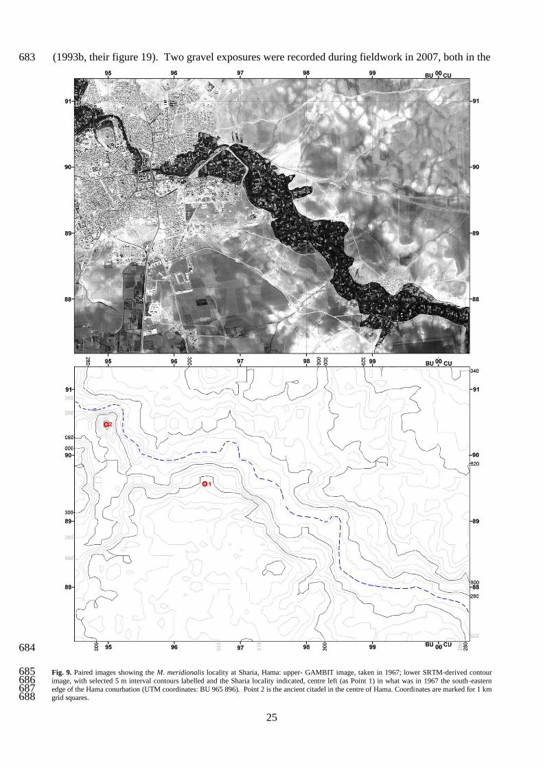
The location of the earlier discovery of a mandible, with teeth, of M. meridionalis at Sharia, near 597
Hama (see above), also coincides with deposits mapped as QfIII by the CNRS workers, although in 598
the original description Van Liere and Hooijer (1961) regarded it as older. This would seem to 599
relate, at least in part, to the fact that Van Liere (1966) underestimated the height of the deposits at 600
Latamneh. Artefacts were also discovered but the assemblage is too small for the absence of 601
evidence for handaxe making to be meaningful. This leaves a conundrum in that ancestral 602
mammoths of different types, and presumed to be at different evolutionary stages, are recorded in 603
deposits that have been attributed to the same Orontes terrace. In an attempt to resolve this 604
problem, the photographs of mammoth teeth provided for Sharia by Van Liere and Hooijer (1961) 605
and for Latamneh by Hooijer (1965) were re-examined. This confirmed that the single R m3 tooth 606
from Latamneh figured by Hooijer (1965) is consistent with an identification of Mammuthus 607
trogontherii. Sixteen plates are apparent on the image but there has been a limited amount of wear 608
at the front of the tooth so this should be regarded as a minimum count. Early Pleistocene M. 609
meridionalis is characterized by low hypsodonty and a mean of 10–14 plates in the third molar, 610
whereas M. trogontherii is both more hypsodont, with between 16 and 22 plates (Lister and Sher, 611
2001). The published images of the Hama tooth allow confirmation of its identification as M. 612
meridionalis, implying a greater age than the Latamneh fauna. 613
Consultation of SRTM imagery (Fig. 9) has confirmed the that the deposits at Sharia (10 m thick) 614
are aggraded to ~40 m above the modern river, as originally suggested by Van Liere and Hooijer 615
(1961), placing them within the height range of the sequence at Latamneh and making the 616
attribution of both sites to QfIII seem entirely reasonable. Possible differences in uplift history 617
23
between the two localities cannot be ruled out however, which could explain the apparently older 618
mammalian remains at Sharia. Indeed, Van Liere (1966) suggested that an older set of deposits, 619
equivalent to those at Sharia, occurred at Latamneh and that the fossiliferous and handaxe-bearing 620
sediments had subsequently been incised into them, although no later descriptions have confirmed a 621
sequence of this sort. 622
The various biostratigraphical evidence thus requires the reattribution of the QfIII terrace, as 623
represented at Latamneh and Sharia, to an age in the region of 1.2–0.9 Ma. This has a significant 624
implication for the age model established for the Orontes by Bridgland et al. (2003; see above), 625
which is confirmed as underestimated. Revised suggestions for the ages of terraces in the Hama–626
Latamneh area are indicated in Figure 7. The ~40 m height of the Sharia deposit suggests a 627
significantly younger age than the aforementioned el-Farcheh site; the somewhat greater height of 628
the deposits at Latamneh, notwithstanding the younger age, is attributed to a component of localized 629
uplift in the vicinity of the adjacent Sheizar Fault (see below and Fig. 8A). Given this revision, it is 630
no longer tenable to consider the Middle Orontes terraces as representative of formation in response 631
to 100 ka Milankovitch climatic forcing (cf. Bridgland and Westaway, 2008a). 632
6. The Ghab Basin 633
About 5 km downstream of Latamneh (along the valley axis) the Orontes leaves the incised part of 634
its middle reach and enters the Acharneh Basin (located to the east of the southern part of the larger 635
Ghab Basin: Fig. 1, inset), passing through a well-marked west-facing scarp slope close to the town 636
of Sheizar (Fig. 8A). Further downstream the valley widens out within the Acharneh Basin to form 637
a large flat plain and all but the lowest Pleistocene terraces disappear. These lowest terraces are 638
represented on the maps of Besançon and Sanlaville (1993a, b) by widespread glacis, mostly 639
forming apparent fans that extend westwards from the scarp; a few of the highest fragments of these 640
are mapped as QfIII, although QfI and QfII dominate and extend along the course of the river 641
downstream to Acharneh, beyond which they too cease to be represented (Fig. 10). Sections 642
beneath the glacis surfaces in the latter area reveal them to be formed on lacustrine sediment of the 643
Acharneh Basin (Devyatkin et al., 1997), probably Neogene in age, that have been slightly uplifted. 644
Downstream of Acharneh the resumes its northward course, flowing above the stacked infill of the 645
Ghab Basin (Fig. 3); this has been widely interpreted as an actively developing pull-apart basin 646
(Devyatkin et al., 1997; Brew et al., 2001; Westaway, 2004b, 2010) the formation of which was 647
probably broadly synchronous with the comparable Hula Basin further south, the initiation of the 648
latter being reliably dated to ~4 Ma from its associated volcanism (Heimann and Steinitz, 1989; 649
Heimann et al., 2009). These structures thus reflect the development of the present geometry of the 650
24
DSFZ, which came into being around that time, at ~3.7–3.6 Ma (Westaway et al., 2004b, 2010; 651
Seyrek et al., 2007). The fact that fluvial aggradational terraces occur only upstream of the Sheizar 652
scarp implies that the latter has formed in response to Pleistocene dip-slip (down-to-the-west) 653
movement of a fault at this location (Figs 3 and 8A). This interpretation was suggested by de 654
Heinzelin (1966) but was overlooked by later workers; indeed, de Heinzelin envisaged that the 655
succession at Latamneh (see above) was deposited before this fault became active, at a time when 656
much of the present relief of the area did not exist. Movement on this fault can be presumed to 657
account for the lack of fluvial incision in the area downstream and the greater-than-expected height 658
(give their biostratigraphical age) of the deposits at Latamneh, ~5 km upstream. 659
Much work was carried out in the Ghab by Russian scientists during the Soviet era, as reviewed by 660
Domas (1994) and Devyatkin et al. (1997), who described a mixed lacustrine and fluvial Pliocene 661
infill that, from geophysical evidence, attains a maximum thickness of 0.8–1.0 km. According to 662
Devyatkin et al. (1997), the maximum sediment thickness occurs in the central–southern part of the 663
basin, thinning to <200 km in the north (Fig. 1, inset). They also reported a lacustrine fill of up to 664
~300 m in the Acharneh Basin. A longitudinal section through the northernmost part of the Ghab, 665
based on borehole evidence (Besançon and Sanlaville, 1993b), shows the majority of the infill, 666
proved to a maximum thickness of 40 m (but unbottomed), to be Pliocene shelly clay, with 667
interbedded sands, volcanic ash and, at the northern end of the basin, basaltic lava (Fig. 11B). This 668
lava, erupted from poorly preserved cones to the north and east of the downstream limit of the 669
Ghab, has been attributed to the Pliocene (Ponikarov et al., 1963b; Ponikarov, 1986; Domas, 1994), 670
although it has yielded K–Ar dates as young as 1.1±0.2 and 1.3±0.9 Ma (e.g. Devyatkin et al., 1997. 671
It is unclear whether the Ghab has been continuously occupied by a lake throughout the Pleistocene 672
or whether there were periods when the Orontes flowed across a dry lake floor, as at present 673
(following anthropogenic drainage). As it approaches the northern end of the Ghab, the modern 674
Orontes channel becomes increasingly deeply incised, partly, perhaps, as a result of the artificial 675
drainage during the 1950s of what was, in historical times, a wetland (Besançon and Sanlaville, 676
1993b). In part, however, this is likely to be a consequence of the river cutting into the basalt 677
barrier as it passes from the subsiding basin interior into an area that has clearly been uplifting. 678
There is evidence for uplift of the basalt barrier during the Quaternary, in the form of inset low-679
level river terrace gravels that border the course of the Orontes along the northernmost 15 km of the 680
Ghab (Domas, 1994). These deposits are well exposed at Karkour, near the northern end of the 681
basin, where Quaternary gravel was recorded by Van Liere (1961) and Besançon and Sanlaville 682
25
(1993b, their figure 19). Two gravel exposures were recorded during fieldwork in 2007, both in the 683
684
Fig. 9. Paired images showing the M. meridionalis locality at Sharia, Hama: upper- GAMBIT image, taken in 1967; lower SRTM-derived contour 685 image, with selected 5 m interval contours labelled and the Sharia locality indicated, centre left (as Point 1) in what was in 1967 the south-eastern 686 edge of the Hama conurbation (UTM coordinates: BU 965 896). Point 2 is the ancient citadel in the centre of Hama. Coordinates are marked for 1 km 687 grid squares. 688
26
689
Fig. 10. Fossiliferous sites in the Ghab Basin: 1960s CORONA image showing the location of (from north to south) the Karkour railway bridge and 690 Karkour sluice sites at the northern end of the Ghab; note that the railway was under construction, with the bridge not yet in place. Insets show the 691 location of sample points from present-day Google Earth. Coordinates are marked for 1 km grid squares, although the image shows a 0.5 km grid. 692
incised banks of the Orontes. First, at Karkour sluice (BV 57282 59073; ~168 m a.s.l.), 1–2 m of 693
cemented medium–fine gravel was exposed, capping an unconsolidated sequence of shelly silts and 694
fine sands above a lower clayey gravel–pebbly clay and culminating in fine gravel with an 695
argillaceous matrix; the basal cemented gravel reveals cross bedding indicative of northward 696
palaeoflow (Fig. 11A; online supplement, Fig. A.1.7). Analysis of the cemented gravel, carried out 697
in the field (as in the Upper Orontes), showed that it comprises >95% flint/chert (Table 1), the only 698
27
other constituent being limestone, which has presumably been introduced from the sides of the 699
basin. Some 2.5 km further north, at the Karkour railway bridge (BV 57306 61493; 165 m a.s.l.), a 700
second gravel exposure was observed. The deposit here, which overlies the basalt that gives rise to 701
the knick point at the northern end of the Ghab, is much coarser than that further south, containing 702
large weathered basalt clasts. It is ~3 m thick, has a variable argillaceous matrix and contains 703
shells, including large gastropods (see below; online supplement, Fig. A.1.8). It also yielded a well-704
preserved handaxe (Fig. 11B) and a butt fragment from a larger handaxe. The flint/chert reaching 705
Karkour has evidently been transported from the Middle Orontes upstream of Sheizar, avoiding 706
deposition as part of the thick stacked succession in the Ghab Basin. Analysis of samples from the 707
two Karkour sites has shown that the sediments contain ostracods as well as molluscs. 708
709
Fig. 11. Karkour, northern Ghab Basin: A- Section log from the Karkour sluice locality; B- Section log from the Karkour railway bridge locality; C- 710 hand axe from the Karkour railway bridge section; D- Apameaus apameae from the Karkour railway bridge section. This species is named after 711 Apamaea, a Roman site in the Ghab. 712
28
6.1 Palaeontology of the Ghab sediments 713
Mollusca were analysed from both Karkour exposures (Table 3). Samples 57 and 58, from silty 714
deposits beneath the cemented gravel at Karkour sluice, yielded assemblages dominated by 715
Dreissena bourguignati (~95% of the total). Samples 60 and 61, from Karkour railway bridge, also 716
yielded well preserved shells, the most distinctive being the large viviparid gastropod Apameaus 717
apameae (formerly Viviparus apameae; Fig. 11C; cf. Sivan et al., 2006). Previous authors have 718
described other fossiliferous exposures in this general area (cf. Schütt, 1988; Devyatkin et al., 1997; 719
see online Appendix 3). 720
721
Table 3: Molluscan faunas from exposures at Karkour (for locations, see Fig. 10; for details see text) 722 723
Sample
57 58 60 61
Theodoxus jordani (Sowerby) + + + +
Theodoxus orontis Schütt +
Apameus apameae (Blanckenhorn) + +
Melanopsis blanckenhorni Schütt + + + +
Melanopsis unicincta Blanckenhorn +
Melanopsis bicincta Blanckenhorn +
Melanopsis cylindrata Blanckenhorn +
Lymnaea (?Radix) sp. +
Gyraulus piscniarium Bourguignat + +
Planorbis carinatus +
Planorbis sp. + + +
Valvata saulcyi Bourguignat + + + +
Semisalsa longiscata (Bourguignat) + +
Bithynia applanata Blanckenhorn + + +
Syrofontana fossilis Schütt + +
Falsipyrgula rabensis (Blanckenhorn) + + +
Falsipyrgula ghabensis Schütt + + +
Potomida kinzelbachi Schütt + +
Unio terminalis Bourguignat + +
Dreissena bourguignati Locard + + + + 724 725
First described by Blankenhorn (1897) based on shells from the Orontes, A. apameae is best known 726
from the Jordan valley, where it has been used as an index fossil to define the ‘upper freshwater 727
series’ or ‘Viviparus Beds’ of the Benot Ya’aqov Formation at Gesher Benot Ya’aqov (Picard, 728
1963; Tchernov, 1973; Goren-Inbar and Belizky, 1989; Bar-Yosef and Belmaker, 2010), noted 729
above as being somewhat more recent than the Latamneh deposits. As at Karkour, A. apameae is 730
found in direct association with handaxes at Gesher Benot Ya’aqov (Goren-Inbar and Belitzky, 731
1989; Goren-Inbar et al., 1992). The species became extinct in the Jordan Valley at ~240 ka, on the 732
basis of U-series dating (Kafri et al., 1983; Moshkovitz and Magaritz, 1987; Heller, 2007). Its first 733
appearance there followed the eruption of the Yarda Basalt, in the vicinity of the Sea of Galilee, and 734
of the Hazbani Basalt, which flowed from southern Lebanon into the Hula Basin in the 735
29
northernmost Jordan valley. Although dating of these basalt eruptions has been attempted using the 736
K–Ar method, this has not resulted in reliable age-determinations (e.g. Schattner and Weinberger, 737
2008). Given the data currently available, probably the best guide to the age of the Hazbani Basalt 738
and of the stacked succession in the Hula Basin is from the biostratigraphical and oxygen isotope 739
calibration by Moshkovitz and Magaritz (1987), based on borehole evidence. They recognized 740
glacial-to-interglacial termination IX (the MIS 20–19 transition) at a depth of ~160 m in the Hula 741
Basin fill, which implies that A. apameae, which occurred between depths of 67 and 168 m in the 742
studied borehole, had appeared by MIS 21. If it is assumed that the occurrence of this gastropod in 743
the Ghab was synchronous with its presence in the Jordon, then it can be concluded that the 744
sediments at Karkour railway bridge are Middle Pleistocene. 745
746
Table 4: Ostracod faunas from faunas from exposures at Karkour (for locations, see Fig. 10; for details see text) 747
Sample
57 61
Cyprideis torosa (Jones) + +
Ilyocypris cf. inermis Kaufmann +
Ilyocypris sp. (spinose form) + +
Loxoconcha spp. +
Candona neglecta Sars +
Candona sp. (juveniles) +
Heterocypris salina (Brady) +
Herpetocypris sp. +
748
Samples 57 and 61 were also examined for ostracods, Sample 57 yielding the most abundant and 749
diverse fauna of seven species (Table 4), amongst which the most common was Cyprideis torosa. 750
The assemblages appear to include reworked and indigenous components, indicated by differential 751
preservation; the reworked material might be as old as Pliocene (see online Appendix 3). Pliocene–752
Pleistocene ostracod faunas from the Levant region have been poorly documented, making this an 753
important record, particularly since these crustaceans are extremely valuable palaeolimnological 754
indicators (Holmes, 1996; Battarbee, 2000). For example, C. torosa occurs in brackish water, 755
developing noded valves in salinities below c. 5‰, but can also tolerate hypersaline conditions in 756
lakes and water bodies prone to desiccation. The indigenous component from the Karkour samples, 757
presumed to be Pleistocene, comprises both brackish (C. torosa and the loxoconchids) and 758
freshwater elements (Candona neglecta, Ilyocypris spp. and an unnamed Heterocypris). 759
The analysis of these two faunal groups thus supports a Pleistocene age for the sediments at both 760
Karkour sites, with reworked ostracods from earlier, possibly Pliocene sediments within the Ghab 761
Basin. It is worth highlighting the close similarities between the palaeontological and 762
archaeological material from the Ghab deposits at Karkour and the Benot Ya’aqov Formation in the 763
30
Jordan Valley; these records, coupled with the suggested contemporaneity of the Ghab and Hula 764
basins, permits a tentative broad correlation to be suggested. This and the above-mentioned K–Ar 765
dates for the basalt at the northern end of the Ghab implies an age range from the latest Early 766
Pleistocene to Middle Pleistocene for the sedimentary succession at Karkour, rather than the 767
Pliocene age previously suggested (cf. Ponikarov et al., 1963b), making it therefore somewhat 768
younger than the deposits at Latamneh. 769
7. The Orontes Gorge north of Jisr ash-Shugour 770
The town of Jisr ash-Shugour is situated at the downstream end of the Ghab Basin, north of which 771
the Orontes enters a gorge, ~100 m deep (although within a wider, deeper feature up to 300 m deep) 772
and ~25 km long (along its sinuosity; see Fig. 12; online supplement, Fig. A.1.9), that it has cut 773
through Palaeogene limestone. At the northern end of the gorge is the town of Darkush, only 3 km 774
upstream of the border with Hatay Province (Turkey). 775
Where this gorge could be accessed it was, unsurprisingly, found to contain no fluvial terraces, only 776
a basal gravel ~0.3 m thick, beneath ~0.2 m of sand with gravel seams and capped by ~1.0 m of 777
silty overbank deposits. This valley-floor sequence was observed and sampled at Hammam ash 778
Sheykh Isa, where the gravel (126 m a.s.l.) proved to comprise mainly limestone (>99% of a 779
somewhat undersized sample: Table 1). This demonstrates that the bedload of the Orontes has been 780
recharged with limestone from the local Palaeogene outcrop, this having greatly diluted the 781
flint/chert clasts that accounted for >95% of the gravel at Karkour. 782
783
8. The Amik Basin, Hatay Province 784
The meandering Orontes channel north-west of Darkush forms the border between Syria and Hatay 785
for a (straight-line) distance of 23 km. To the north the river enters a second subsiding lacustrine 786
basin, formerly occupied by Lake Amik. In this case the lake has disappeared during the last half 787
century, having (along with its associated wetlands) occupied 53.3 km2 in 1972 (Figs 1 and 13) but 788
was eliminated completely by 1987 as a result of drainage for agriculture (Kiliç et al., 2006; 789
Çalışkan, 2008; for notes on its earlier history, see Wilkinson, 1997; Yener et al., 2000). It was also 790
known as the Lake of Antioch, the ancient city of that name (modern Antakya) being situated on the 791
south-western extremity of the Amik Basin, the flat-topped infill of the latter giving rise to the 792
Antioch/Amik Plain. The lake was drained by an artificial channel (the Balıkgölü Canal) into the 793
Orontes, which flows along the southern edge of the basin without reaching the former site of the 794
lake (Fig. 13). 795
31
796
Fig. 12. The gorge between Jisr ash-Shugour and Darkush: 1960s CORONA image of the gorge (for location, see Fig. 1); dotted lines show locations 797 of derived cross sections (see online supplement, Fig. A.1.9). Coordinates are marked for 1 km grid squares. Insets show photographic images of the 798 gorge: A- looking SSW (upstream) from BV 63205 76708, about 5 km east of Qanaya. The mountains visible in the far distance are part of the Jebel 799 Nusayriyah range along the western side of the Ghab Basin.; B- Looking northwards, downstream along the valley, from BV 63234 76771. The 800 gravel sample locality at Hammam ash Shaykh Isa is ~400 m to the north of the viewpoint, accessed from the nearer part of the valley-floor platform 801 in the middle distance. Both photographs show features that might represent early river levels, although other explanations would be possible and 802 ground-truthing has not been practicable. 803
Extending NNE (upstream) from the Amik Basin is the valley of the River Karasu, which follows 804
the alignment of the DSFZ as it trends in that direction, passing into the East Anatolian Fault Zone 805
(e.g. Westaway 2004b; Westaway et al., 2006; Fig. 1). The nature of faulting in this region was for 806
many years a subject of debate, in relation to controversy concerning the geometry of the DSFZ in 807
western Syria. Yurtmen et al. (2002) showed that the evidence was consistent with active faulting 808
along the Karasu valley continuing southward into the DSFZ, with no requirement for any other 809
large-scale faulting extending offshore to the south-west, as others had previously inferred. In this 810
view, the Amik Basin can be interpreted as marking a leftward step in the faulting, from the 811
Amanos Fault, which runs along the western margin of the Karasu valley, to the DSFZ segment 812
further south, which Westaway (2004b) called the Qanaya–Babatorun Fault. Subsequent analyses 813
(e.g. Seyrek et al., 2007, 2008; Westaway et al., 2008) have confirmed this general interpretation. 814
The Amik Basin can therefore be interpreted as another pull-apart basin within the DSFZ, 815
comparable with the Ghab. Although they have yet to be mapped in detail, the existence of active 816
faults in the region is corroborated by records of numerous large historical earthquakes (e.g. Akyuz 817
32
et al., 2006). The Karasu valley is the site of extensive eruptions of Quaternary basalt; offsets of 818
dated basalt flows, where they cascade into the main valley along tributary gorges, have provided 819
the principal method of measuring slip rates on faults in this region (e.g. Yurtmen et al., 2002; 820
Seyrek et al., 2007). 821
It is difficult to study the Orontes to the south-east of the Amik Basin because of the political 822
sensitivity of the Syria–Hatay border, with which it coincides in this area. Once downstream of the 823
border, the river channel can readily be observed as it meanders extravagantly across the Amik 824
Plain. Simple measurements at intervals demonstrate that the bed of the river becomes 825
progressively incised below the surface of the plain as the outlet from the basin, near Antakya, is 826
approached. The Orontes channel was measured as declining from ~3.5 m below the Antioch Plain 827
at BA 54539 18533, ~2.5 km upstream of Alaattin, to ~9.5 m on the northern outskirts of Antakya 828
(BA 48448 15139), over a (straight-line) distance of ~7 km (see Fig. 13, points 4 and 5). 829
Thin cobble-gravel, interbedded with floodplain silt, cropping out in the river bank (north side) 830
~2 m above the Orontes, ~1 km south of Alaattin Köyü (~86 m a.s.l.; Fig. 13, point 2; the source of 831
a clast analysis sample: Table 1), was found to contain pottery, demonstrating a mid–late Holocene 832
age, as well as freshwater mussel shells. Flint/chert from the Middle Orontes has increased in 833
frequency in the river’s bedload here (~10%), in comparison with the Darkush Gorge sample 834
locality ~50 km upstream, despite the much greater distance from its source outcrops than from the 835
Palaeogene limestone (which has fallen to <75%: Table 1). This change can be attributed to the 836
relative hardness and resistance to abrasion of the siliceous clasts, which persist into the gravels of 837
the Lower Orontes, whereas the limestone disappears (see below; Table 1). The Amik Basin 838
sample also contains a fresh input of crystalline material, notably local basalt (>10%), as well as 839
coarser mafic rocks and traces of quartzitic, schistose and amphibolitic rocks. The coarse mafic 840
rocks are likely to be from the latest Cretaceous Hatay ophiolite, whereas the other constituents are 841
probably derived from the Precambrian/Palaeozoic succession exposed in the Amanos Mountains, 842
west of the Karasu, by way of its right-bank tributaries. All such material is exotic to the Orontes 843
valley upstream of this point. 844
Also exposed in the incised channel sides of the Orontes in the Amik Basin are horizontally 845
laminated fine sands and silts, interpreted as fluvio-lacustrine sediments of Neogene–Quaternary 846
age. They were observed in a river-bank section, ~1 km south of Alaattin (Fig. 13, point 1). 847
Comparable deposits, although rather more indurated and gently tilted, were also observed in quarry 848
sections in low hills standing above the Amik plain at Alaattin Köyü (Fig. 13, point 3). These 849
would appear to represent upfaulted blocks of Neogene basin fill; at ~125 m a.s.l., the deposits have 850
been uplifted ~40 m above the general level of the plain. The same upfaulted ridge reaches 159 m 851
33
a.s.l. to the north-west of Alaattin Köyü (Fig. 13, point 6). The absence of any other high ground 852
suggests that this area has been a subsiding sedimentary depocentre for most of recent geological 853
history and certainly since the present geometry of the DSFZ in this region came into being, in the 854
Mid Pliocene (~3.6–3.7 Ma: e.g. Seyrek et al., 2007; Westaway et al., 2008). A seismic reflection 855
profile published by Perinçek and Çemen (1990) indicates that the sedimentary fill in the Amik 856
Basin reaches a maximum thickness of ~1 km. 857
858
Fig. 13. The Amik basin showing the extent of the former Lake Amik (modified from Çalışkan, 2008). For location, see Fig. 1. Field localities are 859 numbered as follows (see text): 1, the Alaattin Köyü clast analysis locality (see Table 1); 2, river-bank section 1 km south of Alaattin Köyü (BA 860 52477 15506); 3, quarry section in upfaulted basin sediments at Alaattin Köyü (BA 52626 16772); 4 and 5, downstream and upstream limits of 861 measurement fluvial entrenchment beneath the Amik Plain (at BA 48448 15139 and BA 54539 18533, respectively); 6, spot-height in the upfaulted 862 sediment observed at 3, at 159 m a.s.l. (~BA 508 200). 863
9. The Lower Orontes, downstream of Antakya 864
Flowing south-westwards from Antakya, the Orontes again enters a high-relief area in which river 865
terrace deposits are preserved sporadically along its incised course (Erol, 1963), before entering the 866
most spectacular of its three gorges, more than 400 m deep, cut into resistant latest Cretaceous 867
34
ophiolitic rocks (Figs 1 and 14). This incised valley makes a dramatic contrast with the low relief 868
in the area of the Amik Plain. Between Aknehir and Sutaşı (BA 30927 97820), for a distance of ~8 869
km, the Orontes follows a particularly deeply entrenched gorge between the Ziyaret Dağı mountain 870
range to the southeast and the isolated Samandağ Tepe hill (summit 479 m a.s.l.) to the northwest. 871
The abruptness of its downstream end (Fig. 14), where the Orontes flows out of a major escarpment 872
that was recognized by Erol (1963), raises the possibility that it is caused by localized slip on an 873
active dip-slip fault (Figs 3 and 14). A fault in this location, near the village of Sutaşı, was indeed 874
indicated by Tolun and Erentöz (1962). Recent interpretations of the regional kinematics (e.g. 875
Westaway, 2004b; Gomez et al., 2006; Seyrek et al., 2008; Abou Romieh et al., 2009) require a 876
component of crustal shortening in the crustal blocks alongside the active left-lateral faults forming 877
the northern DSFZ. It is thus probable that any dip-slip fault in the Antakya area, away from the 878
main left-lateral faulting, would be a reverse fault (cf. Fig. 3) rather than a normal fault. Heights 879
and tentative ages for the marine terraces on the Mediterranean coastline were reported by Erol 880
(1963) and were used by Seyrek et al. (2008) to infer a typical uplift rate of ~0.2 mm a-1
during the 881
latter part of the Middle Pleistocene and the Late Pleistocene. The rate of localized uplift in the 882
supposedly fault-bounded gorge reach may well be significantly higher than this already-high 883
estimate of the regional uplift rate (cf. Demir et al., this issue). 884
In this gorge reach the Orontes falls 50 m in 16 km to the sea south of Samandağı. Former dock-885
side masonry of ancient Seleucia Pieria (the former port of Antioch) can be observed today within 886
agricultural land (at YF 63841 00704), demonstrating relative sea-level fall in this area in the past 887
two millennia. Relative sea-level decline has also been documented from the levels on the quayside 888
masonry of borings by marine molluscs, at up to 0.75 m above modern sea level, and has been 889
linked to historical earthquakes, notably one in AD 551 (Pirazzoli et al., 1991). 890
Study of gravel exposures in this Lower Orontes reach reveals a further input of the crystalline 891
rocks first seen in the Amik Basin sample. For example, a sample collected near Bostancık Köyü 892
(Fig. 14), from an Orontes terrace gravel exposed on the western side of the Antakya western 893
bypass (76 m a.s.l.; ~25 m above the river), contained ~30% basalt and >50% coarser basaltic 894
lithologies, both including badly weathered examples (Table 1). Highly weathered ophioltic rocks 895
were also encountered (14.4%), as well as quartzose lithologies and kaolinized rocks (Table 1). 896
Only a single flint/chert clast was recorded in this sample, which was devoid of limestone. In 897
contrast, a sample collected from a bluff on the left bank of the Orontes at Şahin Tepesi, ~25 m 898
above the river (probably representing the same terrace, therefore), yielded 1.7% flint/chert and 7% 899
35
limestone, the latter assumed to be locally derived (from the Cretaceous marine succession onto 900
901
Fig. 14. A- Synthetic contour map generated from SRTM data showing the Orontes valley downstream of Antakya (for location, see Fig. 1). Faint 902
contours are at 10 m intervals, with dark contours at 50 m intervals, the latter omitted where the relief is too steep. Note the contrast between the 903
broad valley upstream of Aknehir and the gorge reach between there and Sutaşı. The Sutaşı fault is marked, with ticks on the hanging wall. The 904
summit of Samandağ Tepe is marked by its ~479 m spot height. Numbered localities denote the following: 1, viewpoint for Fig. 14B; 2, viewpoint 905
for Fig. 14C; 3, Bostancık Köyü (Antakya western bypass) clast analysis locality; 4, the Şahin Tepesi clast analysis locality. B- Looking north-west 906
(downstream) from BV 32785 95604 along the entrenched gorge reach shown in A. C- Looking NNE from BV 30827 95697 across the exit of the 907
Orontes gorge at the village of Sutaşı, where the river emerges from what is interpreted as a locally uplifted fault block, the margin of which also 908
creates the abrupt escarpment below the viewpoint. 909
36
which the Hatay ophiolite has been emplaced; e.g. Tolun and Erentöz, 1962) rather than transported 910
from Syria. It was comparable with the previous sample in that it was dominated by basalt and 911
coarser basaltic rocks, together with ophiolite and a trace of quartzitic lithologies (Table 1). Erol 912
(1963) included the terrace deposits here as part of his Orontes Terrace II, which is the lowest of the 913
terraces depicted in Figure 3 (his lowest terrace being too close to the river to show at this scale). 914
He correlated this fluvial terrace with his Marine Terrace II, which Seyrek et al. (2008) concluded 915
to be of last interglacial (MIS 5e) age. A direct correlation between fluvial and marine terraces, and 916
Erol’s (1963) resulting age assignment of this fluvial terrace to the ‘Riss–Würm Interglacial’, is 917
unlikely to be tenable, given that current wisdom generally attributes river terrace gravels to cold-918
climate episodes (e.g. Bridgland, 2000; Bridgland and Westaway, 2008b; Bridgland et al., 2008). 919
The reported heights of Erol’s (1963) five Orontes terraces in the reach between Bostancık Köyü 920
and the upstream end of the Samandağ Tepe gorge, 5–7, 15–25, 40–50, 70–80, and 90–100 m above 921
the modern river, are indicative of a regular pattern, suggesting terrace formation in response to 100 922
ka climatic cycles, as in other parts of the world (cf. Bridgland, 2000; Bridgland and Westaway, 923
2008a). The reported terraces can perhaps be correlated with MIS 12, 10, 8, 6 and 2. Uplift rates in 924
this reach of the river during this span of time would thus approach 0.2 mm a-1
, far higher than in 925
localities further upstream. Like in the Ceyhan valley through the Amanos Mountains further north 926
(Seyrek et al., 2008), and in the lower reaches of the Nahr el-Kebir near Latakia in NW Syria 927
(Bridgland et al., 2008), the absence of any earlier record in this reach of the Orontes can be 928
attributed to the rapid uplift; the resulting high relief and the associated rates of slope processes 929
have led to low probabilities for preservation of older river terrace deposits. 930
10. Discussion: possible age and relation to climatic fluctuation 931
Unlike other nearby rivers in Turkey and Syria (Sharkov et al., 1998; Bridgland et al., 2007; Demir 932
et al., 2007, this issue; Seyrek et al., 2008; Westaway et al., 2009b), there are no Pleistocene lava 933
flows interbedded within the Pleistocene terrace sequence of the Orontes to provide marker levels 934
for dating, although the Homs Basalt provides a maximum age for the start of incision by the upper 935
river below the level of the Late Miocene–Early Pliocene lake bed onto which this lava erupted. It 936
has been thought, therefore, that the best indication of age within the sequence comes from the 937
mammalian assemblage from the Middle Orontes (see above). Indeed, Bridgland et al. (2003) 938
previously used the Latamneh terrace deposits as a pinning point for correlation between the Middle 939
and Upper Orontes terrace sequences, having also modelled the latter (see also Bridgland and 940
Westaway, 2008a) using the technique applied widely to terrace systems elsewhere (Westaway, 941
2004a; Westaway et al., 2002; see above). They attributed the formation of comparable terrace 942
sequences in both the middle and upper reaches of the Orontes to cyclic climatic forcing of fluvial 943
37
sedimentation and erosion with progressive incision in response to regional uplift. The similarity of 944
these records to those in rivers elsewhere, notwithstanding proximity to plate boundaries (as in the 945
case of the Orontes) or otherwise (as in rivers in NW Europe with similar uplift histories) was also 946
noted (Bridgland et al., 2003; Bridgland and Westaway, 2008a). The consistent pattern of uplift, 947
seen widely and calibrated in systems with optimal dating control, records acceleration at around 3 948
Ma, followed in many cases by renewed acceleration around 2 Ma, then by decrease during the 949
Early Pleistocene and a further acceleration at around the ‘Mid-Pleistocene Revolution’, when the 950
100 ka climate cycles began (Bridgland and Westaway, 2008b; Westaway et al., 2009a). Each of 951
these phases of uplift is well developed in fluvial sequences within the Arabian Platform, notably 952
that of the River Euphrates (e.g. Demir et al., 2007, 2008; Westaway, 2010). This pattern of 953
persistent uplift is seen, however, only in areas of post-Early Proterozoic (i.e. non-cratonic) crust, 954
older crust being colder and more stable and showing either intermittent uplift and subsidence 955
(Early Proterozoic crust) or, in the case of Archaean cratons, little vertical movement at all during 956
the Late Cenozoic (Westaway et al., 2003, 2009a; Westaway, this issue). Subsiding areas of 957
sediment accumulation are further exceptions to the standard pattern; not necessarily fault bounded, 958
their subsidence is presumed to be a response to sedimentary isostasy. Examples of substantial 959
subsiding regions of this type are the Lower Rhine, beneath the Netherlands (Brunnacker et al., 960
1982; Ruegg, 1994), and the Great Hungarian Plain (Gábris and Nádor, 2007; Kasse et al., 2010). 961
Smaller areas of subsidence are also recognized within the Rhine, such as the Neuwied Basin, 962
where a substantial stacked sequence of fluvial deposits floors a down-faulted block (Meyer and 963
Stets, 2002). The Ghab and Amik Basins compare closely with the last-mentioned European 964
example, as they also occupy small subsiding fault-bounded blocks. 965
It is apparent from the disposition of fluvial gravel terraces in both the Upper and Middle Orontes 966
that the river in both these reaches has migrated westwards during the Pleistocene, although 967
throughout that time it flowed between them through the fixed and entrenched Rastan Gorge. The 968
close coincidence of the modern Orontes course and the eastern margin of the Homs Basalt outcrop 969
can be explained as the result of this westward migration being prevented once the river 970
encountered the resistant basalt, with forms an eastward-inclined interbed within the ‘Pontian’ 971
lacustrine marl. 972
The previous use of the Latamneh deposits as a dating level within the Orontes sequence must now 973
be open to question, since, as noted above, the mammalian assemblage from that locality includes 974
elements that date back to the late Early Pleistocene and would seem to imply an age in the region 975
of 1.2–0.9 Ma. This revision (Fig. 7) effectively doubles the supposed age of the QfIII terrace at 976
Latamneh, with the clear implication that uplift there has been at half the rate previously supposed. 977
38
Account must also be taken of the contradictory indications from the occurrences of different 978
mammoth species within deposits mapped as Terrace QfIII at Latamneh (M. trogontherii) and 979
Sharia, Hama (M. meridionalis), the latter being potentially an older indicator than even the 980
arvicolid L. arankae at Latamneh. It is also now evident that the Latamneh locality is within a few 981
kilometres of an active fault, at Sheizar, that has experienced significant movement during the 982
Pleistocene. It is thus possible that the deposits there might provide a less-than-reliable indication 983
of the regional uplift rate in the Middle Orontes valley, which could explain the indication that older 984
deposits occur at a lower height relative to the modern river in the Hama area. The deposits in the 985
latter area are ~30 km upstream of the faulting and can be assumed to provide a genuine indication 986
of the regional uplift. It is nonetheless clear that the deposits of Middle Orontes Terrace QfIII are 987
significantly older than was suggested in previous publications (cf. Sanlaville, 1988; Bridgland et 988
al., 2003). 989
990
The reinterpretation of the Middle Orontes record raises the possibility that it is comparable with 991
that from other parts of the Arabian Platform, further east in Syria and to the north-east in Turkey, 992
where it has been discerned from the terrace sequence of the River Euphrates. Evidence from the 993
Euphrates points to relatively slow uplift and to a brief period of subsidence in the late Early 994
Pleistocene, during which the valley was partly backfilled with fluvial sediment (Demir et al., 2007, 995
2008, this issue). The resultant thick aggradation, culminating at about MIS 22, has yielded 996
numerous handaxes, although the Euphrates sediments are generally devoid of fossils. It is 997
tempting, therefore, to suggest a correlation with the deposits at Latamneh, which also indicate 998
thick sediment accumulation, have an age (from biostratigraphy) close to the Early–Middle 999
Pleistocene boundary and contain numerous handaxes. The comparable localities in the Euphrates, 1000
indicative of subsidence in the late Early Pleistocene, include sites such as Ain Abu Jemaa, near 1001
Deir ez-Zor, Syria (Demir et al., 2007), and Birecik and Karababa, in southeastern Turkey (Demir et 1002
al., 2008, this issue). A physical mechanism for the reversals in vertical crustal motion that are 1003
implicit in this interpretation is suggested by Westaway (this issue). The subsequent increase in 1004
regional uplift rates that caused a switch from aggradation back to incision in these rivers can be 1005
attributed to the Mid-Pleistocene Revolution, with the more severe cold stages that occurred within 1006
the subsequent 100 ka climate cycles leading to enhanced climatic forcing and a positive-feedback 1007
enhancement of erosional isostasy. At Latamneh area this effect might well have been accentuated 1008
by the component of vertical slip on the Sheizar Fault (cf. de Heinzelin, 1966). Indeed, it is 1009
conceivable that increased rates of vertical motion in opposite senses (i.e. faster uplift in the Middle 1010
Orontes and faster subsidence in the southern Ghab Basin) following the Mid-Pleistocene 1011
39
Revolution affected the state of stress in the region, resulting in initiation or reactivation of slip on 1012
the Sheizar Fault (cf. Westaway, 2006). 1013
1014
There is scant evidence that late Early Pleistocene subsidence occurred further upstream in the 1015
Orontes. Recalibration of the ages of the Upper Orontes terraces (cf. Fig. 4) generally suggests that 1016
the Bridgland et al. (2003) age model underestimates their ages by a single Milankovitch (100 ka) 1017
cycle, given that the number and spacing of the terraces remains suggestive of formation in 1018
approximate synchrony with these glacial–interglacial cycles. The more rapid uplift, in comparison 1019
with the Middle Orontes, that is implicit in this interpretation is in keeping with the evident post-1020
Pliocene uplift of the ‘Pontian’ lacustrine basin (cf. Fig. 3). 1021
1022
The dating river gorges is, in general, difficult and typically relies upon projection of terraces from 1023
upstream and downstream (cf. Fig. 3). The Rastan Gorge is, in fact, an exception, since its incision 1024
can also be constrained by the ages of the Homs and Tell Bisseh Basalt. In particular, the well-1025
constrained age of the Homs basalt provides an upper limit on the ages of the oldest terraces, 1026
comparable in height above the river (Fig. 3), of ~4–5 Ma . It is much more difficult to be clear 1027
about the age of the Darkush Gorge, since it is isolated from well-dated terrace sequences, falling 1028
between the subsiding Ghab and Amik basins. 1029
In contrast to the Upper and Middle Orontes catchment, much higher rates of vertical crustal motion 1030
are indicated in coastal parts of the study region. Setting aside any local effects of active faulting, 1031
as already noted, the disposition of the Orontes and marine terraces downstream of Antakya 1032
indicates an uplift rate of ~0.2 mm a-1
, roughly an order-of-magnitude faster than estimates for the 1033
Middle Orontes, where the inferred ~120 m of incision in the Hama reach since ~4 Ma (Early 1034
Pliocene) equates to a rate of ~0.03 mm a-1
, although if the deposit at Sharia, ~40 m above the 1035
modern river, is as young as ~1 Ma it indicates an accelerated rate of ~0.04 mm a-1
during the last 1036
million years. This estimate of the regional uplift rate can be compared with an independent 1037
estimate of ~0.4 mm a-1
further north in the Amanos mountain range, based on the terraces of the 1038
River Ceyhan, which are capped by datable basalt flows (Seyrek et al., 2008). The uplift rate is also 1039
~0.4 mm a-1
further south in the Latakia area of north-west Syria, on the basis of marine and fluvial 1040
terraces in the region of the Nahr el-Kebir estuary (Bridgland et al., 2008), the latter river draining a 1041
catchment that lies entirely seaward from the course of the Orontes (Fig. 1, inset). Seyrek et al. 1042
(2008) reported on a modelling study that attempted to establish the cause of the high uplift rates in 1043
these coastal regions, which lie close enough to the DSFZ for it to be possible that they are affected 1044
by the distributed crustal shortening (as well as localized faulting) that is required given the 1045
40
orientation and slip sense of this fault zone. However, they found that this process is unlikely to be 1046
the main cause of the rapid regional uplift observed, concluding instead that this is primarily the 1047
isostatic response to erosion. They envisaged a complex sequence of events, with positive feedback 1048
effects, following the elevation of the coastal mountain ranges as a result of plate motions (once the 1049
modern geometry of the plate boundary zone was established at ~4 Ma). Once some initial 1050
topography had developed, orographic precipitation would have been initiated in this coastal region, 1051
as a result of westerly winds from the Mediterranean. The resulting rainfall in turn triggered 1052
erosion, and, given the physical properties of the underlying crust (cf. Bridgland and Westaway, 1053
2008a, b), the resultant unloading drove the observed uplift isostatically. Conversely, sediment 1054
loads, triggered by the same combination of processes, may well have driven the observed 1055
subsidence in depocentres such as the Ghab and Amik basins. It thus appears likely that both plate 1056
motions and climate have contributed to the pattern of vertical crustal motions in this coastal region, 1057
whereas parts of the arid interior hinterland that are well away from any active faults, such as the 1058
Hama area, have experienced much slower uplift, reflecting the lower rates of erosion. 1059
The difference between the ~0.2 mm a-1
uplift estimated for the lower Orontes downstream of 1060
Antakya and the ~0.4 mm a-1
rates in the other coastal regions may result from a significant part of 1061
the deformation in the former area being accommodated by local reverse faults, such as that at 1062
Sutaşı (see above; Figs 3 and 14), whereas in the regions traversed by the Ceyhan and Nahr el-Kebir 1063
it is accommodated entirely by distributed crustal deformation. It is thus possible that the spatial 1064
average of the uplift rates in the terraced reach of the Lower Orontes downstream of Antakya and in 1065
the gorge reach in the hanging wall of the Sutaşı Fault equate to ~0.4 mm a-1
. However, there is no 1066
way of estimating directly the local uplift rate in this gorge reach to facilitate such a comparison. 1067
In the Upper Orontes the uplift rate appears to be significantly higher than in the Middle Orontes; 1068
the age model in Fig. 4 indicates a time-averaged rate since the Mid-Pleistocene Revolution of 1069
~0.09 mm a-1
, more than double the upper bound of ~0.04 mm a-1
for the Middle Orontes over a 1070
similar interval, based on the supposed age of the Sharia deposits (see above). This difference may 1071
possibly reflect the relative erodability of the ‘Pontian’ marl substrate in the Homs area (i.e., faster 1072
erosion is resulting in a faster isostatic uplift response). Alternatively, much of the study region 1073
south of Homs adjoins the NNE end of the Anti-Lebanon mountain range and the western end of 1074
the Palmyra Fold Belt (Fig. 1). It is thus possible that localities in this region are affected by 1075
components of localized deformation (possibly arisng from slip on blind reverse faults beneath 1076
anticlines; cf. Demir et al., this issue). Abou Romieh et al. (2009) indeed noted localized 1077
deformation of Euphrates terraces where the Palmyra Fold Belt crosses this river valley in NE 1078
41
Syria, and inferred significant rates of deformation in more westerly parts of this deforming zone. 1079
Demir et al. (this issue) have shown that the heights of Euphrates terraces in SE Turkey vary 1080
laterally because rates of localized deformation on active faults and folds can be significant 1081
compared with regional uplift rates. 1082
11. Conclusions 1083
The work on the Orontes, reported here, testifies to the value of a pragmatic approach, using 1084
multiple techniques and taking account of data from all relevant sources, in this case field and GIS 1085
survey of terrace morphology and sediments (assisted by dGPS), the use of fossil and artefact 1086
content as indicators of age for particular terrace formations, of clast analysis to identify the 1087
deposits of this river (as opposed to tributaries) and mathematical modelling, to provide a broad 1088
impression of likely ages, calibrated by pinning points and other constraints. 1089
1090
The variable Quaternary record from different reaches of the Orontes underlines the role in crustal 1091
properties and of climate in controlling landscape evolution within particular regions. Although 1092
less well dated than sequences in nearby catchments in Syria and Turkey, it is possible, using the 1093
starting point of the Homs Basalt eruption and the limited biostratigraphical and geochronological 1094
constraint (the last from the U-series dating reported here for the first time), to erect tentative age 1095
models for the sequences in the key reaches. This can be compared with those applicable to 1096
neighbouring catchments, in particular the slowly uplifting interior of the Arabian Platform 1097
(transacted by the Euphrates), to which the Middle Orontes can be likened, and the rapidly uplifting 1098
coastal area that extends both north and south of, as well as including, the lowermost Orontes (cf. 1099
Fig. 3). The repeated changes along the course of the river between uplifting crustal blocks (with 1100
either terraces or gorges, according to the relative resistance of the bedrock) and subsiding ones is 1101
the major contribution of active Quaternary crustal deformation; otherwise the disposition of 1102
terraces in those reaches where they have formed is comparable with regions of post-Archaean crust 1103
elsewhere in the world (Bridgland and Westaway, 2008a, b; Westaway et al., 2009a). The 1104
contrasting record from the different reaches of this single river thus provides valuable insight into 1105
the contrasting types of records from rivers elsewhere that are wholly within individual crustal 1106
blocks. 1107
1108
Acknowledgements 1109
This research includes work that was part of the project ‘Settlement and Landscape Development in 1110
the Homs Region, Syria’, a joint project of the University of Durham and the Directorate General of 1111
42
Antiquities and Museums (DGAM), Syria, and funded by the Council for British Research in the 1112
Levant (CBRL). We wish to thank the ‘Fragile Crescent Project’ (funded by the Arts and 1113
Humanities Research Council, UK) for providing us with satellite imagery data. The research also 1114
includes work undertaken using CBRL funding awarded to DRB, latterly supported through 1115
collaboration with the National Earthquake Center, Damascus, which has supplied both scientific 1116
expertise and logistical assistance. Work in Turkey has been funded in part by HÜBAK, the 1117
research fund of Harran University (grants to TD and AS). 1118
References 1119
Abou Romieh, M., Westaway, R., Daoud, M., Radwan Y., Yassminh, R., Khalil, A., al-Ashkar, A., 1120
Loughlin, S., Arrell, K., Bridgland, D., 2009. Active crustal shortening in NE Syria revealed by 1121
deformed terraces of the River Euphrates. Terra Nova 27, 427–437. 1122
Akyuz, H.S., Altunel, E., Karabacak, V., Yalçiner, C.C., 2006. Historical earthquake activity of the 1123
northern part of the Dead Sea Fault Zone, southern Turkey. Tectonophysics 426, 281–293. 1124
Bar-Yosef, O., Belmaker, M., 2010. Early and Middle Pleistocene Faunal and hominins dispersals 1125
through Southwestern Asia, Quaternary Science Reviews 30, 1318–1337. 1126
Bartl, K., al-Maqdissi, M., 2005. Achäologische Oberflächenuntersuchugen im Gebiet zwischen ar-1127
Rastan und Qal'at Sayzar. In: Orte und Zeiten, 25 Jahre archäologische Forschung in Syrien, 1980–1128
2005, pp. 136–141. Damascus: Deutches Archäologische Institut, Orient-Abteilung, Auβenstelle 1129
Damaskus. 1130
Battarbee, R.W., 2000. Palaeolimnological approaches to climate change, with special regard to the 1131