E- 306 VOL. 2 LIEPAJA CITY COUNCIL LIEPAJA FEASIBILITY STUDY, PRELIMINARY DESIGN AND ENVIRONMENTAL ASSESSMENT OF SUSTAINABLESOLID WASTEMANAGEMENT FOR LIEPAJA CITY AND LIEPAJA REGION ADDENDUM FINAL ENVIRONMENTAL IMPACT ASSESSMENT REPORT SWECO ntfat SWECO INTERNATIONAL in association with GEO CONSULTANTS Stockholm, October 25, 1999 Project No. 1150335 Public Disclosure Authorized Public Disclosure Authorized Public Disclosure Authorized Public Disclosure Authorized Public Disclosure Authorized Public Disclosure Authorized Public Disclosure Authorized Public Disclosure Authorized
OF SUSTAINABLE SOLID WASTE MANAGEMENTFOR LIEPAJA CITY AND LIEPAJA REGION
ADDENDUMFINAL ENVIRONMENTAL
IMPACT ASSESSMENT REPORT
SWECO ntfat
SWECO INTERNATIONAL in association with GEO CONSULTANTSStockholm, October 25, 1999
Project No. 1150335
Pub
lic D
iscl
osur
e A
utho
rized
Pub
lic D
iscl
osur
e A
utho
rized
Pub
lic D
iscl
osur
e A
utho
rized
Pub
lic D
iscl
osur
e A
utho
rized
Pub
lic D
iscl
osur
e A
utho
rized
Pub
lic D
iscl
osur
e A
utho
rized
Pub
lic D
iscl
osur
e A
utho
rized
Pub
lic D
iscl
osur
e A
utho
rized
I
()
CONTENT
I Introduction I2 General I3, Methods of the Work 34 Geological Structure and Hydrogeological conditions 35; Surface Water and Groundwater Quality 76 Possible Access Road 77 Conformity of the New Site to Requirements of the
Regulations no. 38 of February 9, 1999 88 Comparison of the New and Early Selected Sites 8
Tables
11 Description of Geological Cross - section 72 Electrical Conductivity and Temperature of Surface Water 7
Figures
1 Location of the New Site 22 Map of the Quaternary Deposits 43 Geological - Hydrogeological Cross - section 5.4 Direction of Groundwater Flow and location of the Access
Road 6
Appendices
1 Letter no. 1-09/160 from EIA State Bureau, October 1,1999 9
2 Docket from the Grobina pagasts Council Minutes fromSeptember 16, 1999 10
3 Agreement between the Grobina Pagasts Council and Mr.Talis Bergmanis, September 29, 1999 11
4 Descriptions of Bore holes Geological Sections 125 Heights of Bore holes and Groundwater Levels 12
1 Introduction
Liepaja City Council, due to problems with the land owner of the land property"Mezbertuli" (early militarv base in Grobina) Mr. Janis Alens (represented by personauthorized by him - Mrs. G.Klints), has found an other solution. The new areaadjacent to the 'Mezbertulil has been offered as a site possible for a location of thenew landfill for solid household waste. Therefore City Council has asked theEnvironmental Impact Assessment Bureau to stop the evaluation of theEI.A reportwhile a new area will not be investigated.
At October 1, 1999 the EIA State Bureau has passed letter no. 1-09/160 (seeAppendix 1) to the Liepaja City Council, where had explained that the EIA report hasto be supplemented by following:
- drawings showing precise location of a new site,- location of potential access roads,- detailed description of geological and hydrogeological conditions of the
site,analysis of the site advantages and disadvantages in respect to theRegulations of the Cabinet of Ministers no. 38 from February 9, 1999"Solid Household Waste Landfills Installation, Management and ClosureRegulations", especially site correspondence to requirements stated inArticles 4 and 5.
This addendum to the EIA report deals with above mentioned problems. It has beencompiled in October, 1999.
2 General
A new site is located eastern from the early investigated area '¶Mezbertuli" (see Fig.1). In fact, the newA site was recognized as a possible location of a new landfill also inframes of the ELA report. Therefore area is already evaluated from the biologicaldiversity, landscape and other viewpoints, although drilling of bore holes anddetermination of groundwater table were not provided for this particular area.
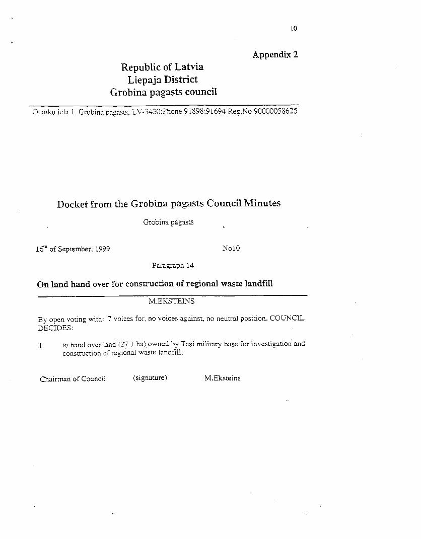
Grobina parish Council has made decision no. 10 (from September 16, 1999) "Onland hand over for construction of regional waste landfill" (see Appendix 2) aftercompletion of the EIA report. Respectively, 27.1 hectare belonging to municipalityhas been offered as site possible for a new landfill location. Almost simultaneouslyagreement between the Grobina parish Council (September 29, 1999) and Mr. TalisBergmanis, owner of the farm "Vilteri", has been signed, because "Vilteri" is locatedin distance less than 500 m from the edge of the site offered for a new landfill (seeAppendix 3).
Owner of the "Vilteri" does not object that a new landfill will be located in distanceless than 500 m from his house.
\~~~B. _.. 5as
. da/as tentonja -. . Xv 'j ' - \,
; (Meib&rtuii) . S274 / t / /
7,~~~~~~~~~~3,
Bocer of off.eredarean
ViosSrlteri100
AkPZiMEJUMIMirq/ae1100
r7 Piedadviftt iecirkna robezas Attalurns starp poligonuBorders of offered area UO > un mfijArn'V\ilteri'
W Distance between edge of landfill1 Urbums. Ta numurs un augstuma atzime, m v.j.l. and 'Vilteri
25,0 (® Borehole. Its number and height, m a.m.s.l. \.N, Agrak pied&vatas teritonjas 'Me±bertulii
d austrumu robezaA 2 Udens elektrovaditspejas merijumu puenkti sI Eastem border
Points of water EC measurements / of early offered area 'Me2bertuli'
1. att. Grobinas pagasta CSA poligonam piedaivat vietaFig. 1: Site offered for a new landfill by the Grobina parish
I
3 Methods of the Work
Supplementary investigations included:- drilling of 5 bore holes (see Appendix 4),- detemiination of absolute heights of bore holes (see Appendix 5).- measurements of groundwater table (see Appendix 5).
Measurements of surface water EC have been provided, and this addendum to theElAreport has been compiled.
4 Geological structure and hydrogeological conditions
The total thickness of the Quaternary sediments is 10-15 m atGrobina site, and at themore than 50% of the cross-section consists of till. Only four types of Quatemarysediments have been found ( see Figure 2):
- technogenic deposits (thQ4), which at the landfill '"oligons" achieve 2-4m, comprising a waste layer of household/ commercial waste,
- alluvial deposits (aQ4) consisting mainly of sand. Sediments have a verylimited distribution and their thickness does not exceed 1.5 m,
- lacustrine deposits of the Latvian Formation (gQ31tv) are located all overthe area adjoining the landfill '?oligons", and consist mainly of sand andsilty sand. Maximum thickness of deposits reaches 4.7 m. Those depositsare found also within the till where their thickness achieves 0.5 m (borehole GS),
glacigene deposits (gQ3ltv) of the Latvian. The formation is developed allover the area and consists of loam or sandy loam with admixture of graveland pebble. The thickness is 7-12 m. Interbeddings of sandy material ( upto 0.5 m) might be found within the till.
5 new bore holes were drilled in order to determine geological conditions at the newsite. It was found, that geological cross - section consists of sandy loam, and itsthickness exceeds 3.5 m (see Figure 3).
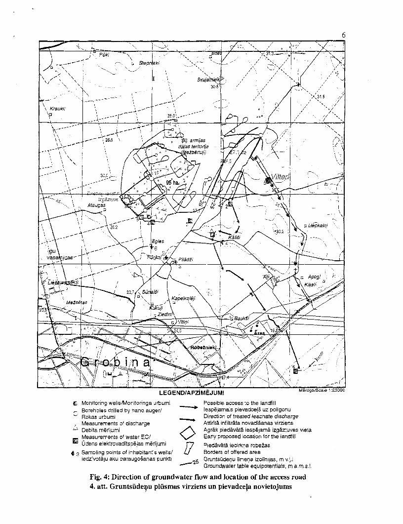
Groundwater table lies on depth 1.3 - 1.8 m below the ground surface. Thegroundwater flow is directed towards the ditch which is directed towardsthe Alandariver, i.e. in south-eastern direction.
In fact, number of puddles have been found on top of the till, although sediments weredry in depth 15-20 cm.
Bcggy and lake deposits have limited distribution in nearest surroundings (see Figure2) and characterized in Table 1.
I
aQ
APZJIMEJUMi I LEGEND Merogs/Scale 1 '95OOl
Ttlsnogeuie norsintissi (thQ4). AtkritsnstiTeisnogenlic deposits (tilQ4,. Waste y\ EArlk piooed lvitAispjam ol teglatdfill et
Proiluviailie UUt deluvifilie nOgssuixtns (pdQ,). Sosilts. grants. Lltl.srllilts N" Erypooe oainfrtelnflProlussial and deluvinl deposits (pdQ,). Sanld. gpavel, sanidy loam Fl7 Pied.iltfit iecirb;a robe2iasA.ltuvialhie nogssstitiu (aQ,). Smilts, aleirtilisla sisslts, grants Li Bordens of offered areaA.uvial deposits (aQ,). Sand. Silty sand, gravel
B sixijas iedus ezera nogolnuxii (lgQ31tv ). Stxsilts. graut.s. oji. aleridts A B Qeologiskfi griezutma ILuila
horizont5laish7oriza1ntal 1 I10000LE NO AZMJ l14 14
LATVIAN FORMATION /LtATVIJAS SVITA LITItOLOGY /LtTOLOGIJA
I 3Q Itv Lacusirine deposits. Sand fine grained sm . . | 1 Fine grained sand I Smalkgraudaina smilts9( sLimn eglaoialie nogulumi. Smalkgraudaina smd ts
Glacigene deposits. Loam with admixture of gravel and pebbles Loam with admiure of gravel and pebleGlacigenie nogulumi. Smilgmals ar grants un olo piemaisijumu 0 0 Smilsmals ar grants un otu piemaisijumu
2- - t - -Groundwater table / Boreholes and their numbers
Grunts0denu limenis Urbumi un to numun
Fig. 3: Geoaogical cross-sectioni at the site "Vilteri"3. att. Iecirkna "Vilteri" geologisksis grieznims
C Monitoring wells/Monitonnga urbumi Possible access to the landfillBoreholes drilled by hand auger/ lespejamais pievadceis uz poligonuRokas urbumi Direction of treated leachate dischargeMeasurements of discharge Attirit& infiltrata novadisanas virziensDebita merijumi Agr&k piedavata iespejama izgaztuves vietaMeasurements of water EC/ Early proposed location for the landfillUdens elektrovaditspejas mrn~jumi ,7 Piedavata iecirkna robesas
* Sampling points of inhabitant's wells/ U Borders of offered arealedzivotaju aku paraugosanas punkti GruntsGdenu limena izolinijas, m v.j.l
Groundwater table equipotentials, m a.m.s.l.
Fig. 4: Direction of groundwater flow and location of the access road4. att. Gruntsuldenu plusmas virziens un pievadcela novietojums
I
A
7
Table IDescripti on of geological cross- ection
Tvpe of Geological Sediments Distribution Thickness,sediments svmbol m
Technogenic th Q4 Waste Extremely Up to 4limited
Lake I Q4 Sand, clay, sapropel, Very limited Up to 2__________ ____________ lake m ud I__
Alluvial a Q4 Sand, silty sand, Limited 0.5 - 1.5Alluvial_a gravel 1Boggy b Q4 Peat Very limited Up to 4.5
Lacustrine lg Q31tv Sand, silt, clay Relatively Up to 4.7.__ _ _ _ _ _ _ _ _ _ _ _ w id elY _ _ _ _ _ _ _ __w_d l
(31acigene g Q31tv Morenic sandy loam All raea 7 -12___________ _____________ and loam _
5 Surface water and groundwater quality
Measurements of EC (see Table 2) carried out in October, 1999 show that surfacewaiter is not polluted, and EC varies in range 304 - 668 4S/cm .
table 2Electrical Conductivity and Temperature of surface water
No ofpoint Conductivity, AS/cm Water temperature, °C
at 1lg_l. 468 9.62>. 467 9.6
I 3. 458 9.64. 668 7.6';. 420 9.2bz. - 304 8.0
Groundwater contamination during EIA study has been found around the existingdurnp site "Poligins". It has rather limited distribution (about 0.6 hectares), and thefollowing parameters characterize the contamination level (well no. 5): COD - 200mgO2 /1, NH4 - 2.5 mg/l, although values of TDS and chlorides are low - only 390mg/l and 22mg/l (natural background values)
6 Possible Access Road
Seems, that the most suitable location of the access road is can be between theLiepaja- Riga highway and offered site, especially taking into consideration that the owner of"Mazbertuli" will not agree with a location of the access road through his landproperty (direction from Liepaja - Ventspils highway side).
Length of the access road will be about 2.5 km, and it will go along following firnmsor will pass their lands:
- "Apogi",
- "Vilteri".
The length of access road, in comparison with early offered site, practically will notincrease, but there is one advantage - it will be not necessary to cross the northernpart of Grobina Town. Hereto, the highway Liepaja - Riga anyway will be used bywaste transporting vehicles.
7 Conformity of the new site to requirements of the Regulationsno. 38 of February 9, 1999
The new site, likely as early selected, responds to requirements stated in Regulationsno 38 "Household landfill installation, management and closure regulations", whichhave been adopted by the Cabinet of Ministers in February 9, 1999.
Nevertheless, there is one problem - the farm 'Vilteri" is located in distance only 400- 450 m from the eastern edge of area supposed to be used for a new landfill. Thisproblem is solved due to efforts of Grobina pagasts Council, i.e. the Council andfarm's owner have signed agreement that the last does not have objections in case if anew landfill will be located closer than 500 m from his house (see Appendix 3).
8 Comparison of the new and early selected sites
Both sites - the new one and early investigated (westem from the new site) can beutilized for a new landfill location.
Envirom-nent conditions (geological structure,hydrogeological conditions, hydrologicconditions, biological diversity, etc.) are almost analogous for both sites. Also lengthof the access road has to be constructed and areas suitability for construction worksare very similar. Therefore, taking into consideration problems with land owner at"Mazbertuli". the new site looks better because the land owner is Grobina pagasts.Therefore, the new area described in this addendum can be recommended for a newlandfill location.
9
Appendix 1Ministry of the Environmental Protection and
Regional Developmentof the Republic of Latvia
State Bureau of Environmental Impact AssessmentRupniecibas iela 25. LV- 1045 (Phone 7321173 Fax 1321049)
Riva
Our 0 1.10.99 No 1-09/160your 29.09.1999 NO 1-21/216
At Mr N.NiedolsExecutive DirectorLiepaja city Council
On Final report on EIA
*State Bureau of Environmental Impact Assessment W'as obtaine'd vour lette'. from29.09.1999 No 1-21/216 with information about moving of potential waste disposalsite in Grobina into northeastern direcTion.
With respect to project time schedule, realised scope of work and comparable shortdistance to new location of potential waste disposal site State Bureau of EIA doesn'tconsider that full scale repetitive ETA procedure has to be executed.In order to finalise statement on Final report on Liepaja region waste disposal siteenvironmental impact assessment State Bureau of EIA. taking into account moreaccurate information, cQnsiders that project initiator or consultant companies have tosupplement the submitted Final report. This report has to be supplemented with:drawings of new-susgested area on maps. description of potential access roads,cornparison of advantages and drawbacks (sirmilar with already assessed territories).geological and hydrogeological characterisation of site. Also accordance with articles4 and 5 of Re-ulation No38 of the Cabinet of Ministers On construction. operationancl closure of sanitary landfills has to be checked and all needed additions have to becdone in relevant chapters and in summary of Final report.
In the same time population of Grobina pagasts has to be informed about new-selected site. We kindly ask to provide State bureau of EIA with a copy ofadvertisement. which will be published. Thus State Bureau of EIA interruptspreparation of statement on Final report until above mentioned additions will besubmitted to the Bureau. We kindly ask by submictingu to make clear or area of offeredsite Muzbertuli needs detailed assessment.
On lancl hand over for construction of regional waste landfill
M.EKSTEINS
By open voting with: 7 voices for, no voices against, no neutral position. COUNCILDECIDES:
to hand over land (27.1 ha) owned by Tasi military base for investigation andconstruction of regional waste landfill.
Chairman of Council (signature) M.ElEksteins
I
I
11
Appendix 3Republic of Latvia
Liepaja DistrictGrobina pagasts council
Otaniku iela 1. Grobina pagasts. LV-3430:Phone 91S98;91694 Reg.No 90000058625
AGREEMENT
Grobina 29th of September, 1999
Grobina pagasts council , represented by chairman of council. Mr Modris Eksteinswho is actinc on basis of law On self-governments, personal code 230443-11946,(further Council) from one side and Mr Talis Bergmanis, personal code 270443-11946 who is owner of Vilteri farm (further Citizen) from other side (further Parties)make agreement on followinz content:
1 Agreement issue
1.1 Parties agree that southern border of regional waste disposal site is located toliving jouse closer than 500 (five hundred) meter.
2 Solution of disputs and responsibility of sides
2.1 If the waste disposal site detiments the products yielded from next locatedland and therefore production couldn't be sold. this Agreement has to becancelled.
2.2 Both Parties agree on issue and will not form claims against it in future.2.3 Disputs Parties solve in way of agreement and if it is not possible than in order
wahich is foreseen in lesislation.
3 Validity of Agreement
4.1 This Agreement is in force from moment of undersigning and has no timelinits for validity
5 Final conditions
5.1 T'his Aarcement is prepared in two copies in Latvian and each Party gets onecopy ot thtrn.
De th. in ness, m symbol_______ _______ Borehole I
0.0 0.25 0.25 1 Soil0.25 2.40 2.15 gQ3 ltv Sandy loam with rare admixture of gravel
I and pebble2.40 2.47 0,07 Ig Q3 ltv Fine grained sand2.47J 3.50 1.03 g Q3 ltv Sandy loam with rare admixture of gravel
_ I and pebble________ ________ Bore hole 2
0.00 0.40 0.40 1 __ -_ Soil0.400 3.50 3.10 gQ3 ltv Sandy loam with rare admixture of gravel
______ I ______ I _______ land pebbleBore hole 3
0.00 0.40 0.40 Soil0.40 3.50 3.10 g Q ltv loam with rare admixture of gravel
an pebble_ ______ Bore hole 4
0.00 0.35 0.35 _ Soil0.35 3.50 3.15 g Q3 ltv Sandy loam with rare admixture of gravel
and pebbleBore hole 5
0.00 0.30 ! 0.30 Soil0.30 1.20 0.90 g Q3 ltV Sandy loam with rare admixture of gravel
I_______,_ and pebble1.20 1.25 | 0.05 I lg Q3 ltv Fine grained sand1.25 2.90 1.65 gQ 3 Itv Sandyloam2.90 3.00 0.10 lg Q3 Fine grained sand3.00 3.50 0.50 g Q3 ltv Sandy loam with rare admixture of gravel
____ ____T_____ and pebble
Appendix 5Heights of bore holes and groundwater levels
Number of a bore Height, m a.m.s.l. Groudwater table, Groundwater table,hole im below the m a.m.s.l.
________________ __________________ _ I E arth's surface _