72
E ALS A PV..re,e.60,<::' E TLANDS R E LIBRARY Marine Science Laboratoq Oregon State University VI E .4
EALS A
PV..re,e.60,<::'
ETLANDS R E
LIBRARYMarine Science LaboratoqOregon State University
VI E
.4

PRELIMINARY DRAFT:
FOR DISCUSSION ONLY
This Document is a Summary ofthe Full Study and is Not Complete
Wetlands Review of
ALSEA BAY, OREGON
Portland DistrictU.S. Army Corps of Engineers
Prepared ByHoward, Needles, Tamen & Bergendoff
Seattle, Washington
in cooperation with
Pacific Planning AssociatesNewport, Oregon
April 1975
TABLE OF CONTENTS
CHAPTER PAGE
INTRODUCTION 1
1. PLAN SETTING 7
2. ENVIRONMENTAL PROFILE 20
3. ESTHETIC PROFILE 23
4. SOCIAL PROFILE 32
5. ECONOMIC PROFILE 39
6. LAND AND WATER USE SETTING 41
7. EVALUATION AND RECOMMENDATIONS 54

INTRODUCTION
OVERVIEW
While Alsea Bay is considered by most Oregonians-- residents andresearchers alike--to be one of the least spoiled estuaries of theentire coast, demands on its resources have grown enormously in recentyears. Since 1971 the Portland District, U.S. Army Corps of Engineers,has processed and approved more than 200 permit applications for docks,moorings and other structures to serve a burgeoning recreational demand.With more people than ever before experiencing the river, questions arebeing raised on limits to growth; how to improve the local economy; andAlsea's role in Oregon's coastal scheme.
In 1972 the Alsea Bay Regional Land and Water Use Plan reportedlocal fears over the proliferation of docks, and recommended largeareas of the Alsea for protection as dunelands, marshlands, or tidelands.By 1974 Lincoln County zoning, which formerly had governed only theimmediate coastal area west of U.S. 101, was brought up to date; landuses were prescribed for upstream areas.
Also during this three-year period, the Oregon Coastal Conservationand Development Commission entered the final phases of its report onOregon Coastal Zone Management to the State Legislature. At the sametime, the Land Conservation and Development Commission investigated howcoastal planning recommendations might contribute to development ofStatewide planning goals.
Coastal research activities of the Oregon Fish and Game Commissions,Oregon State University, the University of Oregon and others continuedthroughout. The intensity of public interest in the estuary was con-firmed locally in the very large response to a public opinion question-naire mailed to Lincoln County citizens by the Portland District in thefall of 1974. Against this background, and as a result of a timelycoincidence of local, State and Federal interests, in June 1974 thisreview of Alsea Bay wetlands resources was undertaken.
Purpose
The Corps of Engineers is one of many government agencies withresponsibilities in the Alsea River region. The particular charge ofthe Corps is regulation of public and private activities in the navi-gable waters of the river. A 1974 revision of regulations formallyestablished the Corps' obligation to protect biologically importantwetlands from degradation by permit activities. In light of growingdemands for permits, this study was undertaken to develop rules andstandards to guide development while protecting these wetlands.
A large part of this report thus is devoted to explaining howbiological, esthetic, social and economic factors exert pressures forconservation and for development, and showing where these pressuresappear to conflict. Once the issues are defined for each segment ofthe river valley, recommendations are made to help resolve them.Finally, the long-term effects on the Alsea River of implementingstudy recommendations are explored.
All permit activities do not affect the natural environmentequally. Treating all applications as if they did threaten equal harmcauses delay and impedes the legitimate activities of citizens, yetprovides no guarantee that potentially damaging projects will receivethe detailed examination they should have.
WETLANDS REVIEW
Assumptions
1. It is a desirable and achievable national goal, shared by theState of Oregon, to maintain the coastal ecosystem of Alsea Bay in itshighest and best ecological condition and to limit adverse disturbancesof the ecosystem as much as possible.
2. Submerged and submersible lands in the navigable waters ofthe Alsea Bay and River are resources held "in trust" for the benefitof the public as a whole, without regard to ownership.
3. Shorelands may or may not be considered as resources "held intrust" for the benefit of the entire public, but as a minimum constitutea scarce national, State and local resource demanding extraordinaryattention.
4. Governmental agencies and shoreland owners have correlativerights and responsibilities with respect to use of wetlands and ad-jacent resources.
5. The Portland District has no major projects of its own inAlsea. It is assumed that any future projects assisted by the Corpsof Engineers or other Federal agencies would require consideration ofseparate environmental impact statements. The study, therefore,emphasizes the Corps' responsibility to regulate seaward influences onthe coastal ecosystem rather than providing detailed consideration ofthe effects of constructing specific projects.
6. The highest enforceable standard or regulation set by anylevel of government for water quality, air quality, land use and otherelements within the study area should apply.
7. To the extent possible, the exercise of the permit authorityby the Portland District should be consistent with adopted regional,State and local comprehensive master plans and zoning.

tu
home*cemelmiftee TILLAMOOK COUNTY
M1 Pen
LINCOLNCITY
Glendon Beech
Lincoln Beed
0.1. ft
Cape Feu Nee
One, Back
Atone BeechTap laaa Need
Laced. L.
LEGEND:
wutumnm SILETZ AND ALSEAREGIONAL PLAN AREAS
771,7171111 PORT OF ALSEA
Nashville
Newport
southo...h
WALDPORT
Burnt Wale to C>0?au
i
-4,
IT
Orlrti
Tich.ow
LiA SEA BAY
IMIKokne nnennolminimenmeilorrenmm77m
tiL:\ 4.171Petilt
Techets,itsit4--. _Ca, Naga Nua
LANE COUNTY
NORTHMeM
O MILES 4
Exhibit 3 LINCOLN COUNTY, OREGON
8. The recommendations of this review complement rather thansupersede existing regulations of the Portland District regardingpermits for activities in the navigable waters of the Alsea.
9. The public's interest and active participation is an essentialelement of a successful study or proposed development affecting thecoastal zone.
Decision Process
This draft report is preliminary and is submitted only as a meansfor gaining further comments, ideas and suggestions from the generalpublic, and from Federal, State and local agencies prior to its com-pletion in July 1975.
Interested citizens will have continuing opportunities to contri-bute their views and insights to the Wetlands Review as it progresses.A public workshop will be held at Waldport, Oregon on April 17, 1975,for the purpose of discussing study findings to date. Although thepublic workshop is intended to be very informal, written statementsmay be submitted as well. Comments may also be mailed to the PortlandDistrict, Corps of Engineers, P.O. Box 2946, Portland, Oregon 97208.
All comments received. during this period will be considered duringrevision of the draft report.
A revised draft report is due to be released to the public inJuly 1975. It is the desire of the Portland District that the finalrecommendations of this study conform as closely as possible to thelong range needs and desires of the citizens who care most about theAlsea Bay and River. The time and effort by those who review andcomment on this draft report is sincerely appreciated and most welcomed.
WETLANDS DESIGNATION
Summary of Authorities
This is one of two initial Wetlands Review undertaken by theU.S. Army Corps of Engineers on the Oregon coast, as authorized by arevision of 33 CFR 209.120, Permits for Activities in Navigable Watersor Ocean Waters, effective April 3, 1974. This regulation requiresthat the decision whether to issue a permit be based on an evaluationof the probable impacts of the proposed permit activity, and that itreflect the national concern for protection and orderly development of
important resources.
Among the public interests specifically mentioned in the regulationare wetlands which are considered "important to the public interest."
These include:
(a) Wetlands which serve important natural biological functions,including food chain production, general habitat, and nesting, spawning,

rearing and resting sites for aquatic or land species.
(b) Wetlands set aside for study of the aquatic environment or assanctuaries or refuges.
(c) Wetlands contiguous to areas listed above, the destruction oralteration of which would affect detrimentally the natural drainagecharacteristics, sedimentation patterns, salinity distribution, flushingcharacteristics, current patterns, or other environmental characteristicsof the above areas.
(d) Wetlands that are significant in shielding other areas fromwave action, erosion, or storm damage. Such wetlands often includebarrier beaches, islands, reefs and bars.
(e) Wetlands that serve as valuable storage areas for storm andflood waters.
(f) Wetlands which are prime natural recharge areas. Prime re-charge areas are locations where surface and groundwater are directlyinterconnected.
Further, the regulation addresses the serious environmentalmanagement problem posed by the cumulative impact of incrementalchanges. Unless it is shown that the public interest requires other-wise, the regulation provides that no permits for activities in suchareas will be granted. In general, proposals for activities in theseareas will require preparation of environmental impact statements andpublic hearings; the burden of proof will reside with the applicant toshow that granting these permits would contribute overriding publicbenefit.
Definition of Wetlands
It is the purpose of this Wetlands Review to identify and recommend"wetlands considered to perform functions important to the publicinterest" and to develop standards for evaluating permit applicationswithin these wetlands. It is necessary to balance the Federal regula-tion (33 CFR 209.120) with other authorities listed in Table 1, andwith State and local requirements, which are discussed in more detailin Chapter 2, Plan Setting.
Under these local, State and Federal guidelines, the WetlandsReview has identified two specific types of wetlands within the studyarea:
1. "Wetlands of importance" are identified as areas of importantnatural biological functions, such as habitat value, food productivity,high diversity, uniqueness, low disturbance and resilience, as well asareas of high recreational, social and esthetic values. These are areaswhere no permit activities would ordinarily be approved.
2. "Areas of concern" are all other areas listed in 33 CFR 209.120,including study areas, water storage or recharge areas and other highlyvaluable ecosystems. Also judged to be areas of concern are lands withsevere physical hazards, such as floodplains, steep landslide areas, anderodible banks; and areas with high esthetic value. The channel andriver are identified as "critical areas" due to their navigation andfisheries uses. Certain activities can be permitted in both criticalareas and areas of concern. However, extreme caution and conditioningare necessary to avoid environmental degradation.
All recommended "wetlands of importance" and "areas of concern" areshown on Exhibit 5.

77
1
/7
20
ALSEA WETLANDS OF IMPORTANCE
LEGEND:
WETLANDS OF IMPORTANCE
AREAS OF ENVIRONMENTAL CONCERN
HEAD OF HAV/GA7/ON
RIVER NILE ill
29
29 T/DEW4TER27
LIMIT OF
TIDEWATER
RIVER MIL
33 36
100, 0 COO 1000 0000 4000 0000
SCALE I'll
THIS BASE MAP HAS BEEN PREPARED FROM MAPPINGOF THE OREGON DIVISION OF STATE LANDS, TN!LINCOLN COUNTY PLANNING COMMISSION AND THEUS. GEOLOGICAL SURVEY.
EXHIBIT 5

TABLE 1
FEDERAL LEGISLATION RELATING TO CORPS or ENGINEEPS PERMIT ACTIVITY
Title Section
Coastal Zone Management 307(g)Act
Marine Protection, Re- 302
search and SanctuariesAct
Fish and Wildlife Actof 1956
Migratory Marine GameFish Act
Fish and Wildlife Coor-dination Act
Reorganization Plan No.4, and Fish and Wild-life Coordination Act
Federal Power Act of1920
National HistoricPreservation Act of1966
Interstate Land SalesFull Disclosure Act
Water Resources Plan-ning Act
River and Harbor Actof 1899
River and Harbor Actof 1902
Requirement
Requires State certification that proposed permit activity in a coastalzone is consistent with the State's Coastal Zone Management Plan.
Gives Secretary of Commerce authority to control all activities incertain zones designated for protection. No such zones are presentlydesignated in the study area.
These three Acts express the concern of Congress for the aquaticenvironment as it affects the conservation, improvement and enjoy-ment of fish and yildlife resources.
Requires that any modification or control of a body of water be pre-ceded by consultation with the U.S. Fish and Wildlife Service, theNational Marine Fisheries Service and the head of the State wildlifeagency.
Physical structures of a power project, including dams, placed underjurisdiction of Federal Power Commission. COE must approve plans whennavigability of a meter,av is affected. Activities of COE that mayaffect properties listed in the National Register of Historic Placesmust be reviewed by the Council.
Activities of COE that may affect properties listed in the NationalRegister of Historic Places must be reviewed by the Council.
In the event that a lot subject to the full disclosure provision ofthis act is in a "wetlands" area, HUD requires certification thatno permit for development has been granted by COE under River andHarbor Act of 1899.
To the extent that COE grants of permits may affect the plans of riverbasin commissions established by this Act, COE must coordinate withthe commissions.
9 Requires COE permit for any dam or dike across navigable water of theU.S. Responsibility for causeways and bridges is now vested in U.S.Coast Guard.
10 Requires COE permit for all obstructions to or alterations of thenavigable waters of the U.S. Includes dredge and fill.
11 Requires COE permit for activities seaward of established harbor lines.
13 Requires COE permits for discharge of "refuse" in the navigable watersof the U.S. Permit function now transferred to EPA.
14 Permits leasing of U.S. property (jetty, dike, pier, etc.) to privateindividuals.
1 Requires COE permit for private improvement of navigable river.Improvements under this authority are primarily in Federal projectareas.
Federal Water Pollution 404Control Act
Marine Protection, Re- 103search and SanctuariesAct
Federal Water Pollution 401Control Act
National EnvironmentalPolicy Act of 1969
Empowers Secretary of the Army to issue or deny permits for dredge anddisposal at particular sites, after due and public examination ofadverse environmental impacts.
Requires COE permitin ocean waters.permit under thisimpact.
for transportation of dredged materials for dumpingEPA Administrator can prevent the issuance of asection in cases of probable unacceptable adverse
Requires State water agency certification that permit activity involvingdischarge into the navigable waters will not violate applicablestandards.
Provides for the orderly assessment of environmental impacts of major
Federal action.
1. PLAN SETTING
PLANNING RESPONSIBILITIES
For purposes of the Wetlands Review, the term "plan" should not beinterpreted in the traditional sense. It is not a guide for resourceallocations in specific geographic areas over stated periods of time.Rather, this chapter summarizes the programs, missions, and responsibili-ties of a spectrum of governmental and citizen interests that beardirectly on the permit authorities of the Corps of Engineers.
According to the Oregon Coastal Conservation and Development Commis-sion, decision-making regarding estuaries presently involves localgeneral-purpose government (cities and counties), single purpose agencies(ports and sanitary districts), and numerous State and. Federal agencies.Further, no single agency possesses the authority or resources to manageall aspects of the estuarine resource and no policy yet specificallyrequires the adoption of local estuary plans.
Selected for discussion here are:
1. The Oregon Coastal Conservation and Development Commission.
2. The Pacific Northwest River Basins Commission.
3. Lincoln County.
4. The Alsea Regional Land and Water Use Plan.
5. The Oregon Division of State Lands.
6. Other State agencies.
7. The "public trust" nature of Oregon's submerged and submersiblelands.
Oregon Coastal Conservation and Development Commission (OCC&DC)
In 1971, Oregon Statute 191.140 created the Oregon Coastal Conser-vation and Development Commission with the goal of preparing a compre-hensive plan for the preservation and development of the natural resourcesof Oregon's "coastal zone." The Commission, consisting of representativesfrom coastal cities, counties and ports, as well as appointees of thegovernor, submitted its report to the State legislature in March 1975.Areas addressed by the Commission include:
1. general coastwide policies for the management of coastalresources;

2. specific policies (based on general policies) which have beenmodified to reflect local conditions and are applied to particulargeographic areas;
3. maps designating specific management areas in the coastal zonewhere specific policies are to be applied;
4. an implementation program, which designates action to be takenby State agencies and local jurisdictions to carry out the managementpolicies;
5. other information required by the Coastal Zone Management Actof 1972.
Within the study area, Lincoln County, the City of Waldport and thePort of Alsea have all been represented on the Commission.
Commission activities and investigations are partially funded bythe Office of Coastal Zone Management, National Oceanic and AtmosphericAdministration, U.S. Department of Commerce. As summarized above, itswork has been conducted in part to meet the requirements of the CoastalZone Management Act of 1972. Oregon's Coastal Zone Management Plan isreportedly far advanced of similar efforts by many other coastal Statesunder the Act and its progress is a matter of nationwide interest.
Public debate over OCC&DC's recommendations has raised severalissues that must be resolved once basic policy questions are settled bythe State legislature and by the Secretary of Commerce under the CoastalZone Management Act.
One fundamental issue in Oregon is the integration of coastal zonemanagement with Statewide planning goals being developed by the LandConservation and Development Commission under Senate Bill 100. It is
impossible at this point to predict the outcome. Further, it is notclear what role the Portland District may eventually be expected to per-form in the complex interplay of Federal, State, regional and localauthorities which bear on the same coastal resource base, or the extentto which Federal and State agencies responsible for coastal resourcesought to deal more directly with local and regional agencies such asOCC&DC for purposes other than regulation.
It is certain that the permit authorities exercised by the PortlandDistrict under the River and Harbor Act of 1899 will be influenced bybasic coastal policies emanating from the Commission.
Further, the public interest requires that government at everylevel conduct its business as consistently as possible. For thesereasons, the Wetlands Review has relied on resource inventories preparedfor the Commission even though the Commission's final recommendationswere not available for incorporating in this draft of the Wetlands Review.
Two issues can be addressed at the outset. The first is whether ornot State and local government should establish a permanent managementcenter for each major estuarine area to provide for planning, regulation,data storage, interpretation, research and education activities as wellas meeting and hearing procedures. According to OCC&DC discussionmaterials:
It is anticipated that the management center wouldbe part of an existing office, such as a countyplanning department. Its purpose is to provide, inone location, a complete identification of allactivities taking place in the estuarine area - a"clearinghouse" where the decisions taking placeat the local, State and Federal level may beevaluated in terms of short and long-term impacts(both economic and environmental). Funds would beprovided by those local, State and Federal agencieswhich would benefit from the coordination activitiesprovided. Funds through the Federal Coastal ZoneManagement Act could be used for such a purpose.
The second is whether State and local governments should select estuarineareas for different levels of management within a comprehensive planningprocess ranging from intense development to preservation:
Specific activities, such as dredging and filling,would be considered by the appropriate decision-making agency in terms of its consistency with theplan. At a minimum, these plans would includethe comprehensive plans required of cities andcounties within Oregon, the State coastal zonemanagement program, and the wetlands plan beingprepared for Oregon estuarine areas by the U.S.Army Corps of Engineers. Those estuarine areaswhich encompass a number of jurisdictions mightrequire additional planning, through a partnershipof Federal, State and local interests to preparea document which could be adopted by allparticipants at respective levels of government.
The study team has concluded that in the absence of a comprehensiveestuary plan such as discussed above, disposition of permit applicationstends to produce the following results:
1. Public uncertainty and confusion over long- and short-termestuarine management goals and procedures.
2. Inefficiencies, and often unnecessary delays, in the handlingof routine permit applications.
3. Investment uncertainty for locally-sponsored projects thatmay be both economically and environmentally sound.
4. Loss of potential public financial and technical assistance tolocal jurisdictions charged with broad planning and management responsi-bilities.
5. Ad hoc local resource decisions that may be both economicallyand environmentally unsound but that are prompted by a lack of meaning-ful options and alternatives available to local agencies.
It is possible that Alsea Bay may be one of the most choice candi-dates along the Oregon Coast for prompt initiation of comprehensive localestuarine planning:
1. Under aggressive leadership in the past few years, LincolnCounty has prepared adequate inventories and instituted local land useplanning and zoning to serve as a basis for future detailed estuarinework.
2. Public interest is sufficiently high.
3. Resource choices will become increasingly limited in the future,indicating a potential for future conflict rather than cooperativebenefit.
4. Ocean-oriented resources on the Alsea are relatively unspoiledand require sensitive management.
5. Upriver resources on the Alsea are in need of restoration andimprovement.
Pacific Northwest River Basins Commission (PNWRBC)
Under the Water Resources Planning Act of 1965, the Pacific North-west River Basins Commission is entrusted with the development ofcomprehensive water and related resource plans for large river basinswithin the Pacific Northwest states of Washington, Oregon, Idaho,Wyoming and Montana. The Commission, consisting of representatives fromFederal and State resource agencies, has contributed both technical andfinancial support to the work of the Oregon Coastal Conservation andDevelopment Commission. In March 1974, for example, the Commission spon-sored a public questionnaire on citizen preferences for management ofspecific estuaries within Oregon. Basic economic data on coastal re-sources management were provided to OCC&DC in a report prepared jointlyby the PNWRBC and the Portland District, Corps of Engineers. PNWRBCstaff and agency representatives continue to provide technical supportfor OCC&DC deliberations.
Of local significance to the Alsea area is a Commission- sponsoredstudy ("Level B Study"), sponsored by the Oregon State Water ResourcesBoard, on water supply and other problems within the Mid-Coast Basin.Potential reservoir sites and other alternatives to provide necessarywater supplies (primarily municipal) in the Mid-Coast Basin reportedlywill be identified. No such alternatives are expected to affect theimmediate study area, but principles and standards for water and relatedland resources require that the plan consider downstream effects, particu-larly on coastal environments; e.g., maintenance of fresh water suppliesto estuaries, fish spawning and migration, and floodplain developments.The plan is scheduled for completion in 1977.
Lincoln County
Lincoln County, also represented in OCC&DC, has anticipated a needfor land use planning and development standards to protect its citizensand coastal and estuarine-related resources within its jurisdiction.This is reflected in 1) county zoning ordinances, 2) floodplain develop-ment standards, and 3) standards governing conditional uses that includedocks, dredging, buikheading and other activities for which the Corps ofEngineers (and in most instances, the Division of State Lands) has con-current responsibility.
The standards and criteria recommended to the Portland District inthe Wetlands Review have taken all county requirements into account, andto the extent possible are consistent with them. As a minimum, therecommendations of the Wetlands Review provide protection to naturalresources equal to that afforded by local ordinances. Lincoln County or-dinances deal in general with the following:
1. Shoreland zoning for marine waterways, natural resource zones,and standards for scenic corridors and scenic roadways. (See Exhibit 30and Table 30 in Chapter 6.)
2. Conditional use standards governing filling, dredging, draining,disposal of dredge spoils, wharfs, bulkheads and similar devices; piers,docks, boathouses, and similar facilities; and outdoor recreation facili-ties.
3. Floodplain development standards and procedures.
In addition, Lincoln County has basic responsibility for regulationof public activities in areas prone to geologic hazards such as flooding;and in areas affected by such catastrophic occurrences as tsunamis.Because Lincoln County has qualified for the Federal Flood Insurance Pro-gram, the presumption is that such hazards are accounted for in zoningand floodplain development standards. In areas of frequent flooding, apermit for subsurface disposal of sewage is required from the county.
Implications of Lincoln County zoning ordinances on study arearesource development are discussed in Chapter 6, Land and Water UseSetting.
Alsea Bay Regional Land and Water Use Plan
Lincoln County adopted the Alsea Regional Land and Water Use Planin July 1972 as part of its overall county plan. Basic provisions withinthe study area are displayed in Exhibit 6 and in Table 2. The Plan wasbased upon recommendations of a Task Force representing the City ofWaldport, Waldport Planning Commission, the Board of Lincoln CountyCommissioners, the Lincoln County Planning Commission, and local repre-sentatives of State resource agencies. Its purpose is to providenecessary guidelines to "encourage continued growth of those types offacilities which are essential to the economic stability of the area,without diminishing the livability or deteriorating the natural beautyand estuarine and timber resources which made the area so desirable inwhich to live." The plan was intended to serve as a basis for zoning butseveral inconsistencies between local zoning and the Plan persist. Key
features of the Plan either include or call for:
o A recommendation to create an "action program" an earlyreference to the need for comprehensive estuarine management.
Revival of small boat basin development.
O An increase in the role of the Port of Alsea in bay developmentactivities such as moorage, launching facilities, snag removal, pile re-moval and a groin and jetty proposal for the inlet, including activitiesthat would help finance Port operations.
O A step-up in water and sewer service from Waldport east to LittleSwitzerland, opening up an additional 1,500 acres of land "suitable fordevelopment."
o Improved parking and traffic circulation in downtown Waldport.
O Acquisition of bay frontage for tourist and park development.
O Discouragement of "strip" development along Highway 101 and
Route 34.
O Preservation and restoration of the character of Old Waldport.
O Increased housing availability, particularly downtown.
O Encouragement of aquaculture and non-degrading industries.
O Acquisition of the Junior High School for a community center
(built on filled lands).
12
TABLE 2
ALSEA BAY MASTER PLANNING
Length of Shorelinea
Zoning Feet MilesPercent inStudy Area
Notes
Single Family
Recreation ResidentialRural ResidentialMulti-FamilyGeneral CommercialTourist Commercial
Marine CommercialRecreation CommercialMarshland
Farm/Forest/Recreation
8,000
64,0007,0001,0000
1,500
6,0000
21,500
59,000
1.52
12.121.330.190
0.28
1.140
4.07
11.17
4.78
38.094.180.60
00.88
3.580
12.79
35.10
6,000 feet onocean and dune
4,500 feet onocean and dune
22,000 feeton island
Sub-Tot l 168,000 31.82
Dunel, tut .
Recreation (Resource)3,0005,500
0.57
1.03 2,000 feet onocean and dune
TOTALS 176,000 33.42
aExcuding Drift. Creek, Eckman Lake and Marine Production Area.
Source: Howard, Needles, Tammen and Dergendoff, 1975.
13

ALSEA REGIONAL LAND ANDWATER USE PLAN
TOURIST COMMERCIAL
RECREATION/RETAIL COMMERCIAL
MARINE COMMERCIAL
SOURCE:
ALSEA REGIONAL LAND AND WATER USE PLANRENDERED BY PACIFIC PLANNING ASSOCIATES /HNTB MARCH 1975

O Establishment of a major north/south route one half mile east of
Highway 101 for future local traffic from Yaquina to Alsea Bay.
O Protection of public values in beaches, estuaries, river andstream shorelines as an "ever diminishing commodity;" limit uses to
those which require water frontage or need water orientation.
o Initiation of a local, State and Federal program for marshland
and tideland acquisition.
Initiation and enforcement of standards for scenic roadways and
corridors.
Establishment of development standards based on soils and slope
limitations.
Revegetation of developed areas.
o Initiation of a study of alternative solutions to proliferationof docks continously along the channel. "Although all of the effects of
such docks are not known, it is not felt that continuous dock construc-tion along the channel can have a beneficial effect on either waterquality or navigation. Alternative solutions might include periodic
boat basins, more launching ramps, etc."
The implications of the Plan for permits is discussed in Chapter 6,
Land and Water Use Setting.
Division of State Lands
The Division of State Lands has basic responsibility for the pro-tection, conservation and best use of water resources of the State.
Included among its authorities are the issuance of State permits for
removal of materials and for filling of submerged and submersible lands,
and regulation of structures over navigable waters. The authority is al-
most identical to that exercised by the Corps of Engineers.
The Division comments on permit applications received by the Portland
District and coordinates comments from such State agencies as the Fish
Commission, Wildlife Commission and the Department of Environmental
Quality. As a matter of policy, the Portland District ordinarily does
not approve permits over the objection of the Division of State Lands.
An untested question is whether the Portland District will deny a permit
that has previously been approved by the Division of State Lands.
In Oregon, as in other estuarine States, controversy over permits
has generally involved filling. In 1972 Governor McCall declared a six-month moratorium to permit the Division of State Lands time to conduct a
selective review of pending applications. Permits for fill involving
over 50 cubic yards of material in submerged or submersible lands were
14
either granted or denied based on an evaluation of the factors describedbelow. Fills must be:
1. Consistent with the paramount policy of the State to preservethe use of its waters for navigation, fishing and public recreation.
2. In conformance with sound principles of conservation and con-sistent with the public health and safety.
3. In conformance with existing public uses of the water, and withduly enacted zoning and land use plans.
An inventory of filled lands in Alsea Bay prepared by the Divisionin 1972 has been incorporated in the map of disturbed areas appearing inthe Environmental Profile (Exhibit 9). The extent of fill recorded bythe Division is far less than has been identified through the WetlandsReview, 24.7 acres as opposed to 151 acres. The reasons are that inapproximating the extent of fill, the Wetlands Review did not differen-tiate between "Trust" lands as defined by the Division (areas betweenthe Mean High Water Mark and the Mean Low Water Mark) and areas withinthe jurisdiciton of the Corps of Engineers (tidelands submerged at MeanHigher High Tide). Further, additional fills have been noted on theAlsea since the Division's report in October 1972.
Filling is perhaps the most irreversible activity within the navi-gable waters and is one that affords the greatest opportunity for pre-emption of public rights. Further, their purpose and location tends toprejudice consideration of subsequent permit activities (dredging, bulk-heading, moorage and development within the floodplain).
In addition to Division of State Lands regulations, an OCC&DC"discussion draft" on the Estuaries and Wetlands Resources of the OregonCoast suggests consideration of additional criteria, specifically "thatState and local governments prohibit the filling of estuarine areas unlessthe following conditions are found to exist:"
1. The fill satisfies existing statutes, administrative rules andcriteria of the Oregon Division of State Lands.
2. The proposed uses will provide a public benefit.
3. The fill will be the minimum amount required for the proposeduse.
4. Locating the proposed fill in other areas where it would createless adverse impacts is not practicable.
15

RasINTI
DEVELOPED
iz)
DIKED PASTURE
6
IS7
CC
111
AGRICULTURE
CREE
REVELOPE
RESERVOIR
DEVELO
DEVELOPED
UNFLUSHED CHANNEIL
AGRICULTURE
*11116112J
/1
DEVELOPEG
ilpio11111111111111"AL 5:EA
1;i11111111111 liWar4-2
14111!"1111
HAFILL DISTLIRHO ARSH
111111111111911110
R VER111111111111111iiiill
11111011111v
lulllllllllllllllllllllll
2 AGRICULTURE/HOUSIN
HIGH 34
20
ALSEA DEGREE OF ECOLOGICALDISTURBANCE
LEGEND:
111111111
[ 1
CC
GRICULTURE
CC
CC
VERY SEVERE (Fills)
SEVERE (Dovulopod,Roserveir)
MODERATE (DilmAgriculture-,Cl arcul,Low Density /Rural Development)
LOW (Old Cluarcut,Racreational Usto,Main Estuary IA River)
CLEARCUT PATCHES
HEAD OF NAVIGATION
RIVER MILE 11.2 CC
CC
RESERVOIR
1111111111111111111
1111
,, 1DEVELOP
CC
29
DEWATER27
CC
AGRICULTURE
ILL /DEVELOPMENT
DEVELOPED
DEVELOPED
AGRICULTURE
TIDE WA TED EVELOPE
/11102--MILAGRICULTURE
DEVELOPEDCC OPED
35 36
POO 0 1000 /WOO WOO 1000 3000
SCALE
TN /S BASE AMP HAS SEEN PREPARED FROM MAPPINGOF THE OREGON DIVISKTN OF STATE LANDS, THELINCOLN COUNTY PLANNING COMMISSION AND THEU S 6EOLO6KAL SURVEY
CC 0+ CLEARED FOR DEVE OPMENT
OREGONGRAVEL ROAD
AGRICULTURE
SOURCE:
CAROL JEFFERSON PhD MAPS .19751971 AERIAL PHOTOGRAPHS - HNTRINVENTORY OF FILLED LANDS IN THE ALSEA RIVER . 1972INTERPRETED AND RENDERED BY HNTR
CC
CC
CC
CC
CC_
CC
CC CC
EXHIBIT 9
5. The proposed use of the fill conforms to adopted estuary plans.*
In addition, OCC&DC has considered a recommendation that pilings beused as an alternative to fill, but notes that interpretations of thesuggested policy would lead to differing levels of impact on the estuary.The implications as interpreted by the study team are discussed in a sub-sequent section on the "Public Trust."
Whatever policies finally emerge from the public debate on OCC&DC'swork, both the Corps of Engineers and the Division of State Lands will beobliged to evaluate them further in the light of existing Dederal andState statutes, court decisions, realities of developing specificestuarine plans should they materialize, and court interpretations of aconcept recognized in Oregon as the "public trust."
Other State Agencies
The programs and responsibilities of other State agencies have directand in some cases paramount importance for the management of resources inthe Alsea study area. Too numerous to describe in detail, they can besummarized as follows. Several are referenced in other portions of thetext. Comments by these State agencies on specific permit applicationsto the Portland District, Corps of Engieners, are coordinated through theOffice of the Governor utilizing the separate but simultaneous permitauthority of the Division of State Lands.
Oregon State Engineer. Policy, regulatory and management functionsas they apply to water resources surveys, watershed protection and floodprevention projects, reclamation projects in marsh and submersible landsand installation and maintenance of stream gaging stations.
Department of Environmental Quality. Policy, regulatory andmanagement authorities as they apply to water pollution control, preven-tion and abatement and consultation requirements of other State agenciesincluding notification by the Division of State Lands prior to Stateleasing of tidal and submerge,' lands; property tax exemptions and incometax credits for pollution control facilities.
Oregon Fish Commission. Policy, regulatory and management authori-ties including notification by the Division of State Lands prior to Stateleasing of submerged and submersible lands; notification by the StateHighway Commission prior to issuance of permits for removal of productsalong ocean shores; and installation of fishways and hatcheries inscenic waterways.
*As discussed earlier, local estuary plans have not yet been adopted.Further, according to OCC&DC, the general prohibition against fillswould only apply to open waters, submerged and submersible lands andtidal marshes of estuarine areas not to estuarine shorelands, exceptin very limited circumstances.
16
Department of Geology and Mineral Industries. Authorities to issuepermits for geologic and geophysical surveys on tidal submerged andsubmersible lands and leases.
Soil and Water Conservation Commission. Authorities for watershedconservation and development, including prevention of soil erosion,flood control, maintenance of the navigability of rivers and harbors,and protection of wildlife, natural beauty and recreational opportunities.
Water Resources Board. Policy, regulatory and management authorityover water resources of the State, including the preparation of comprehen-sive plans for water supply, recreation, wildlife, fisheries, water pol-lution abatement, flood control, floodplain management and reclamation;particularly authority, jointly shared with the Division of State Lands,to regulate filling and removal of materials from the beds and banks ofthe waters of the State; and coordination by other State agencies ofprograms affecting the waters of the State.
Land Conservation and Development Commission. Policy and planningrecommendations leading to the adoption of State-wide planning goals.*
"THE PUBLIC TRUST"
The common law principle of the "public trust" is being applied withincreasing regularity by Federal and State courts in cases involvingthe use or disposition of estuarine resources. The principle has beensummed up in the words of J. A. Holmes, Secretary to President TheodoreRoosevelt's "National Conservation Commission" in 1909:
The resources which have required ages for theiraccumulation, to the intrinsic value and quantityof which human agency has not contributed, forwhich there are no known substitutes, must serveas the welfare of the Nation. In the highestsense, therefore, they should be regarded asproperty held in trust for the use of the racerather than for a single generation; and for theuse of the Nation, rather than for the benefitof a few individuals who may hold them by rightof discovery or purchase.
*The role of the Land Conservation and Development Commission in coastalplanning with respect to OCC&DC is one of the major policy decisionsyet to be made by the State legislature. The brevity of this descrip-tion does not do justice to the issue or to the mission of the LCDC todevelop Statewide planning goals. In fact, the very complexity andweight of the issue precludes detailed description and analysis inthis report. For further information, contact OCC&DC, P. 0. Box N,Florence, Oregon 97439 or LCDC.
17

Modern commentators cite the underlying practicalities of the "trust"principle:
1. Some resources are of such importance that it would be unwiseto make them the subject of private ownership; if already in privateownership, society has the right to expect that they be protected andmanaged to account for the public as well as private interest. Thisappears to be an extension to societal interests as a whole of the legaldoctrine: "Use your property but in such a manner as not to injureanother."
2. The resources are such that government should use them to promotethe interest of the general public rather than to redistribute them frombroad public uses to restricted private benefits.
The submerged and submersible lands of the Alsea Bay and River tothe Mean High Tide, regardless of ownership, are recognized as trustresources within the State of Oregon. Manifestations are the statutoryand administrative requirements of the Division of State Lands; severalnotable State court decisions; and the legal opinions of the State'sAttorney General. The practical result in terms of permissible activi-ties such as diking, dredging and particularly filling, cannot be over-emphasized.
The "trust" tends to define the correlative rights and responsibili-ties of the public vis a vis the rights and responsibilities of riparianowners; moreover, with more clarity than in narrowly constricted casesonly involving riparian law. Some commentators assert that riparian lawis confusing, too localized and often contradictory to serve as anappropriate guide for management decisions involving estuaries. In con-
trast, whenever the principle of the "public trust" has been invoked,common questions by the courts tend to emerge repeatedly:
1. Will the resource remain effectively within the public interestwith respect to navigation, fisheries and recreation, including esthetics?
2. Will the uses of the area be devoted to public purposes andmade accessible to the public?
3. Will diminution of the resource be relatively minor, i.e., willa lake, for example, continue to be a lake?
4. Will any of the uses guaranteed to the public be totally destroyedor greatly impaired?
5. Has "due process" been followed?
6. Is the activity "necessary" to accomplish public purpose?Analogous to commerical law dealing with the relationship of trustees tothe beneficiaries of the trust, is it, in other words, necessary to
destroy the object of the trust (the estuary, for example) to improve thetrustee's benefit?
These general guidelines gleaned from court decisions have majorimplications for two recommendations considered by the Oregon CoastalConservation and Development Commission: 1) the suggestion that minimumacreages be set for Oregon's estuaries before filling is totally pro-hibited and 2) the requirement to use piling in lieu of fills wheneverpracticable, which according to OCC&DC's analysis is subject to a dualinterpretation.
Whatever policies finally emerge, under the common law there existsa presumption in favor of continuing the resource in its existing stateunless it can be demonstrated that the public benefit would exceed thepublic loss, through disposition, conversion by landfill or other activi-ties. This is not to imply that economic benefit is not a criteria of"benefit" but that it is only one of a number of criteria, includingnavigation, fisheries, recreation, esthetics and maintenance of ecologicalintegrity. A burden of proof involving more than economics alone, there-fore, must be born by those who would potentially infringe on this trust.The Wetlands Review suggests that in the Alsea study area this burdencannot be borne 1) in the absence of a comprehensive plan for Alsea Bayidentifying among other things those activities that necessarily requireuse of submerged and submersible lands; and 2) in the absence of anevaluation of the availability of alternative sites for such uses.
1Discussion Draft on Estuaries and Wetlands, OCC&DC, August 1974.

2. ENVIRONMENTAL PROFILE
METHODOLOGY
Maps were drawn to display the natural and man-made environment.Elements mapped and analyzed include beaches, dunes, sandspits, tidalinlets, rivers, sloughs, floodplains, steep slopes, and tideflats.Differentiations were made between modified and unmodified forms,stabilized and active areas, and natural and man-induced effects.
An extensive literature search and review provided the informationbase for this study. A preliminary literature search yielded hundredsof general coastal sources. From these, approximately 80 Oregon-relatedreferences were selected, including many useful publications produced byOCC&DC and State management agencies. Highly technical dissertations andspecific data from other field studies were incorporated into the litera-ture review.
Data covering the physical characteristics of geology, soils andhydraulics, and data relating to productivity, water quality, biology,distribution and harvest, diversity and other environmental parameterswere analyzed.
After review of published and unpublished materials, personal con-tacts were made by study team members. State and Federal officialsprovided data and maps. Interviews continued with knowledgeable indivi-duals in public agencies and at Oregon State University. In general,
these personal contacts with professional biologists were more valuablethan published data.
Maps and photographs were gathered and interpreted. Aerial photo-graphs, taken in 1939, through the 1960's, and in 1972 and 1974, werestudied. Field investigations to verify data extracted from maps andphotographs were conducted by foot, boat, car and light airplane.
The section of the report on environmental description forms thebasis for permit program recommendations. All data and conclusions ofanalysis have been mapped at the same scale so that comparisons amongmaps can be made and composite drafts of those maps as presented here.The study area has been divided into basic physical units to facilitatepresentation of the geological, topographical, biological and hydrologicalrelationships which make up and.condition the existing environment.Critical relationships have been deteimined from an analysis of inter-actions between environmental elements as displayed in the map series
appended. (Exhibits 14, 16, 17, 22, and Table 3.)
20
Pelagic Beach Primary Sec. Back Gravel Submerged Tideflat Low Immature High Upland
----
Dune Dune Dune
t!'';-4
..-..Shore Channel
Sand-
stone Cliff
Marsh HighMarsh
Marsh
f19.,
)ti/..q`c ia
KelpPlankton
SalmonCutthroatTunaHerringAnchovyShadSoleShrimpWhaleSealGullScoterAukletMurre
BeachgrassAnnualsCloverRed fescueBearberry
PloverGullSand crabPill bugSandpiperSmeltPerch
Coastal pineSalalMyrtleBrackenfernHuckleberry
BeetleSpiderMiceSparrow hawkAntsCaliforniaSparrowGoldfinch
Fir
SprucePineCedar
ChickareeBlue heronPigeonShrewCoast mole
quail Chipmunk
Diatoms Plankton Diatoms EelgrassAlgae Algae Algae
CockleTurns tone
SoftshellShrimpShorebirds
SealHerringClamsDucksCohoChinookSteelheadCrab
SculpinSurfperchFlounderCutthroat
CrabSealFlounderGhost shrimpClams
MusselBlue heronPloverKilldeerSandpiperGullWhimbrelDunlinSoleSculpinPigeon
Seaside arrowSand spurryThree-square rushSalt grassSedge
LimpetSnailCrabShrimpClamsBrantDucksGeeseSwansBlue heronHerringSmelt
Tufted hair grassSalt grassRushCreeping bentMarsh cloverGlasswort
MuskratNutriaMinkOtterMallardPintailCootWigeonBlue heronShorebirdsYoung fishCrabs
PigeonDeerMinkMuskratRaccoon
OtterNutriaShrewVoleSealDucksBlue heronSparrow
AlderFirBlackberry
DeerElkOwl
BearGrousePigeonWarblerCoyoteBobcatMountain quailWoodpeckerGoshawk
Source: Howard, Needles, Tammen & Bergendoff, 1975.
EXHIBIT 14
FLORA AND FAUNA PROFILE
THIS BASE MAP HAS BEEN PREPARED FROM MAPPINGOF THE OREGON DIVISION OF STALE LANDS, THELINCOLN COUNTY PLANNING COMMISSION AND THEU S. GEOLOGICAL SURVEY

12
/3 TBI7
CREEK
20
ALSEA SLOPE HAZARDLEGEND
O % -9% SLOPE
10%-19% SLOPE
LANDSLIDE TOPOGRAPHY
FAULT LINE (Doffed Where Concealed)
HEAD OF NAV/GAT/ON
RIVER II/LE 1/.2
29
77DEWATER
C)
27
THIS BASE MAP HAS BEEN PREPARED FROM MAPPINGOF THE OREGON DIVISION OF STATE LANDS. THELINCOLN COUNTY PLANNING COMMISSION AND THEU.S. GEOLOGICAL SURVEY
SOURCEENVIRONMENTAL GEOLOGY OF LINCOLN COUNTY 1973
EXHIBIT 17

tr,e,o' en'
/0
/2 7
IB/7
CREE/C
20
ALSEA FLOOD HAZARDLEGEND
FLOOD PLAIN (100 Year)
HEAD OF NAVIGATION
RIVER MILE /IR
29
r/DEWATER27
35 36 3/ 3
6 000 0 COO 2000 3000 0000 3000
SCALE 0,,
THIS BASE NAP HAS BEEN PREPARED FROM MAPPING SOURCE:
OF THE OREGON DIVISION OF STALE LANDS, 7NE U.S.C.O.E. PORTLAND - 1971LINCOLN COUNTY PLANNING COMMISSION AND THE FLOOD HAZARD INFORMATION CHARTS, ALSEA RIVERU S GEOLOGICAL SURVEY LINCOLN COUNTY - 1973
LOCATION OF FLOOD MONUMENTS
LIMIT OfTIDEWATER
RIVER AlTh-3-73-12---
EXHIBIT 22
TABLE 3
BAY STUDY REGION
Habitat Types
En
PO4iuaW
o..,
0
oP,A>6
0.aCCl00'-,4
0
u
1oCuw,O
mk 01W 4-IA 00 Cl &z .
,4,..-1.., ,
44 00 0E-o
1 0P P
D.. P-1
.,4.Cl3a00r4
Cl.0.
.,-4
.--4
,-.1
Cl)
W04
w0C.a.P04,0
"-I
01
0'-40
,04.1
.,-4
.00=
.0Cl
Q/ WW 00 vi03 0'0 00 0.W w
Cl
o
.--IoCo5ClWw
EI-4W 04-1 00 4-I, uCA C./
0 0U 0
C.1 1.4
u,-4,-I.0Cr
PwuM3
,, bo0 00 .r1LA 1-1r1 (.)w p,4.1 U001 04
o.,4 to
§ 4al P0. 0W 0gx0,04-1 0W d
...,
00 000 0
4-1 744.1 4.,
w 05 IVz 04
P A0 UP
>l IC1, w0 04., 01w 04
Cl
00NkW
u-IW01
IAo,0P
M
-ci
o0
..-iW
C.o.-IP.
-1:1
o0.--IW
0P 0Cl ., ,03 'V 41) 0 ,-4'0 0 00 u
3 k0 0,4F4 .-4 c.)0 C.
Inlet
Ocean
Beach/dune
high
low
high
30
53
3
low
low
low
yes
yes
yes
good
good
good
low
low
high
low
high
low
no
yes
yes
ves
yes
yes
high
high
mod.
high
high
x
low
low
low
no
yes
no
no
no
yes
no
no
no
no
no
yes
no
no
no
x
x
x
x high
x high
yes
Channel
Tideflats
Eelgrass
high
high
very
46+
10+
10+
low
mod.
high
no
no
no
fair
poor
fair
low
low
low
high
high
high
no
no
no
yes
yes
yes
mod.
high
high
high
high
high
mod.
high
high
yes
yes
yes
yes
yes
yes
yes
no
yes
no
yes
yes
yes
yes
yes
x
yes
x
x high
x
x mod.
Marsh
River
Wet meadow
high
high
very
27+
29
19
high
low
high
no
no
no
poor
fair
poor
low
low
mod.
high
high
high
no
no
no
yes
yes
yes
high
high
low
high
high
low
high
mod.
mod.
yes
yes
no
yes
yes
yes
yes
yes
yes
yes
no
yes
yes
yes
yes
x
x
yes
x low
x high
yes low
Riparian
Field/farm
Woodlands
high
mod.
low
25
15
17
mod.
mod.
high
yes
yes
yes
good
good
good
mod.
high
high
high
mod.
high
no
no
yes
yes
no
no
low
low
low
x
x
x
mod.
low
low
no
no
no
yes
no
yes I
no
no
no
yes
no
no
yes
yes
no
yes
yes
x
x x
x x
x x
Man- dominated
DevelopedFloodplain
mod.
mod.
2
2
low
low
yes
yes
good
good
high
high
low
low
no
no
no
yes
low
low
x
x
low
low
no
no
no
no
no
no
no
no
no
no
x
yes
x x
yes x
x - Not applicable.
1 Valuable as estuarine function to coast.
Sources: Thompson and Snow, 1974.Howard, Needles, Tammen and Bergendoff, 1975.

Like love, the Coastal Zone is a manysplendored thing. Its ecosystem is a splendidrelationship between ocean and beach, betweenmarshlands and uplands, and between man andhis environment.
Honorable Senator Ernest F. HollingsChairman, National Ocean Policy Study2
3. ESTHETIC PROFILE
INTRODUCTION
How to measure "splendor?" More important, how to hold onto thefading images of a splendored past? From pilings and driftwood, marshesand riffled tideflats, one strains to experience a former, wilder Coast.Every evidence points to the conclusion that the last 50 years of man'shabitation has taken a heavy toll on the opportunities for estheticexperience within the Alsea study area. Interestingly, this deteriorationparallels the trend of ecological disturbance discussed elsewhere in thisreport. Only the ocean is constant.
To the newcomer in particular, the setting has become "park-like."One can share in the observation of William M. Roth, Past Chairman, SanFrancisco Planning and Urban Renewal Association:
. . . I would surmise that a park (and by compar-ison Oregon's central coast) is a place where manmeets nature in one or more of its many facets.The meeting, however, is not necessarily a naturalone; it is more likely to be contrived. The earlypioneers pushing over the Rockies into the uppervalleys of the Coastal Range confronted nature,but as the Donner Party attested, they met onnature's terms - not theirs. In a park experience,on the other hand, the odds should be more even.Neither should nature overwhelm man to the extentthat he loses, in desperation and terror, a senseof his own being, nor can man, in an excess ofhimself so overwhelm nature that it is entirelytransformed.
I do not mean to imply that a park is naturedefanged, torn from its own heritage, abstracted.Rather that it is, in.a way, a vision of thenatural world as seen through human eyes and ears. . . Thus, the human imagination creates theconceptual reality: in the oceans of Melville,the forests of Cooper, or the prairies of Parkman,the wilderness observed is related to the psychicwilderness within . . .
So it is with the Coast!
23

TECHNIQUE OF EVALUATION
Esthetic appreciation of the environement is generally intuitive andsubjective. Esthetic evaluation can be judgmental and objective. Butcertain conditions must be satisfied. First, the methods used mustaccount for the widest possible range of opportunities for appreciationofferred by the environment. Second, the evaluation should account forspecific differences within the environment. Finally, the assumptionsthat underpin the evaluation must be understood. Two that are appropriateto the Wetlands Review are derived from a recent report to OCC&DC.
Visual Resource Analysis of the Oregon Coastal Zone:
Mankind finds meaning and emotional securitythrough integrated relationships within theenvironment.
Edges have significant meaning biologically;and awareness of the edge helps develop a strongsense of place for all life forms.
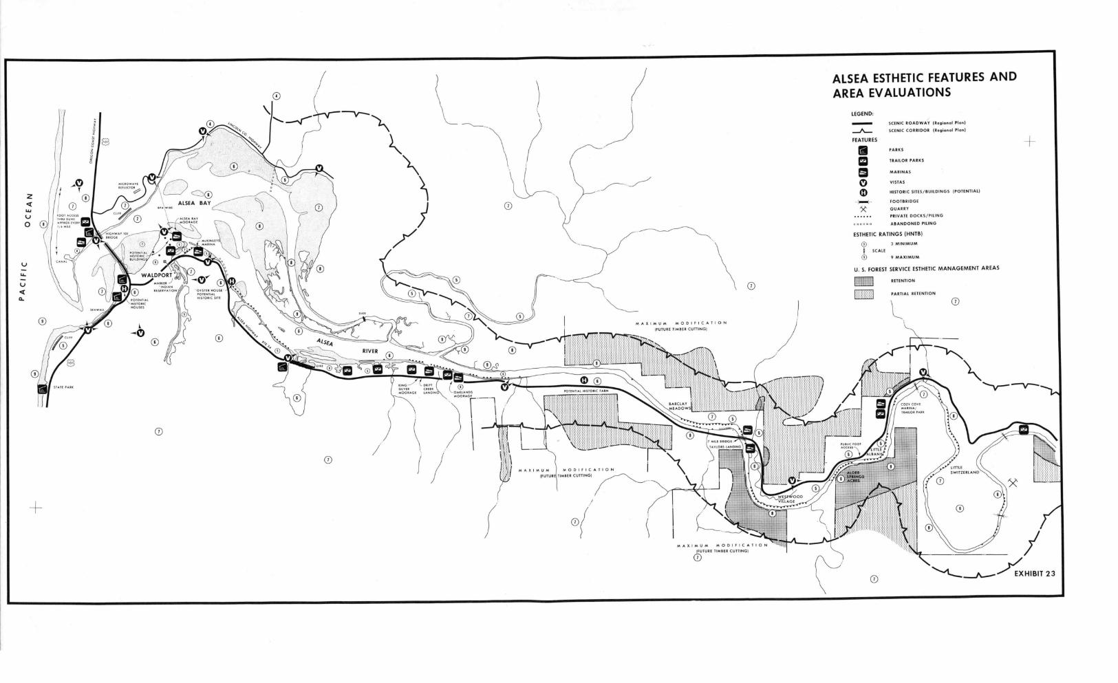
Exhibit 23 represents the results of esthetic evaluation within thestudy area. It contains the following:
1. Symbols displaying significant features.
2. The boundaries of the study area where Lincoln County scenicroadway and scenic corridor ordinances apply.
3. Areas recommended by the U.S. Forest Service for esthetic manage-ment. Full retention is equivalent to no timber cutting; partial reten-tion equals selective cutting; and maximum modification equals clearcut-ting.
4. A numerical score expressing esthetic rating.
The rating is based on a consideration of three factors:
1. The extent to which an environment has been modified. Natural,unstructured environments offer more opportunities for esthetic experiencesthan those which have not. This is not to imply that an unmodifiedenvironment is necessarily more desirable, but only that it offersopportunities for a greater variety of experiences, including the optionof changing a natural environment to suit future needs, which may alsoprovide an esthetic experience. For example, the marshlands between thenorth and south channels of Alsea Bay hold the potential for an infinitelylarge variety of esthetic experiences. Exhibit 24 shows this inverserelationship between degree of modification and the range of estheticoptions retained by a landscape. (The esthetic experiences listed arerepresentative only.) Since cultural landscape modification is generally
24
irreversible, intensification of human activity in a landscape graduallyprecludes the relatively rare natural esthetic experience, while retainingfor the future only relatively commonplace suburban experience.
Environments offering the fullest range of esthetic options havebeen given a rating of 3 (most options). Environments offering less thana full range of options have been rated as 2 (partial options); whileenvironments offering the fewest options have been given a numericalrating of 1.
2. The extend to which an environment can recover, i.e., beimproved back toward more esthetic opportunities.
Environments can be classified according to their ability or inabili-ty to withstand modifications and still maintain opportunities for esthet-ic experiences. This is the analog of the biological principle of"resilience." For example, because of its physical characteristics (soils,slope, geological substrate, exposure to the elements and so forth) theBayshore sandspit, the high bluff and bay beach east of Highway 101 andthe marshes are more sensitive to esthetic changes than the upper duneat Bayshore or the upstream floodplains. The latter environments are, inturn, more sensitive than filled land, gently rolling uplands or even theopen ocean. Ratings have been applied on a declining scale from 3 to 1:fragile (3); sensitive (2); and insensitive and/or improvable (1). Im-provements can take many forms, including natural revegetation, land-scaping, restoration of buildings, etc. (For example, the historicflavor of "Old" Waldport could be partially reestablished by the use ofpiling and docks instead of fill, and the maintenance of abandoned pilingsin lieu of their removal or replacement by incongruous structures.)
The extent to which esthetic opportunities are potentiallyavailable to people. Because of history, tradition, accessibility, edu-cational or social value, certain locations offer more opportunities forappreciation by more people than others. Upper Lint Slough is not onlythe site of scientific investigation in close proximity to the WaldportHigh School, but serves also as a park-like setting for the Ray CoxSenior Citizens Center. The peninsula at Sheppards Point, while havingsome historic interest, is virtually inaccessible. Sites have been ratedaccording to this principle as 3 (most valuable), 2 (more valuable), and1 (least valuable).
COMPARISON WITH OCC&DC METHODS
The esthetic technique used here differs from the techniquepresented in OCC&DC's Visual Resource Analysis in one essential way.The OCC&DC report grouped representative landscapes by "image regions"and the extent to which the landscape has a "coastal association," i.e.,more or less potential for evoking a coast-related experience. Tables4 and 5 set forth OCC&DC definitions, land use prescriptions and designconsiderations for each level of "coastal association." The needs of
25
DEGREE OFMODIFICATION
Unmodified Few and Slight Clianges Cabins and Marinas
NA 'Sense of wildness 'Sighting waterfowl 'Contrasting natural
T 'Sighting native 'Sensing early history and man-made patterns
UR
mammals'Sensing human insig-
'Sensing solitude'Sensing power of
'Sensing how designcan fit nature
nificance nature over human 'Sensing power of the
'Studying naturalpatterns
efforts elements by a warmfire
'Feeling kinship with
RANGE OFESTHETIC OPTIONS
early settlers
Residential DevelopmentM
Sensing security from 0force of nature
'Enjoying nature reshaped 1
in "natural" patternsSensing regret that thewild past is lostforever.
'Sensing social cohesion
Exhibit 24. RELATIONSHIP OF LANDSCAPE MODIFICATIONS TO RANGE OF ESTHETIC OPTIONS. The normally
irreversible process of landscape modification progressively reduces the residual esthetic options
of a landscape. Residual options possessed by a modified landscape are readily available in modern
society; experiences related to unmodified environments are relatively unavailable.
N.)
Exceptional CoastalExperience
Delineates combinations ofrepresentative landscapesplus features. Includedare areas along coast thatwarrant special attentionbecause of a unique repre-sentative landscape, com-binations of representativelandscapes with a highdegree of diversity in asmall area or an accumu-lation of value due tounique or dense features.
Image Region 1Otvious and StrongCoastal Experience
Midcoast beachGrassy dunesActive dunesDeflation plainTimbered headlandMeadowed headlandLakes in duneOpen oceanSand spit
TABLE 4
OCC&DC LAND USE PRESCRIPTIONS
Image Region 2Less Obvious Coastal
Association
EstuaryMarshSloughTideflatFill
Terrace w/croplandTerrace w/trees andmeadows
Dune complex
Image Region 3Subtle CoastalExperience
Pastoral dunes with trees
Image Region 4Weak CoastalAssociation
Timbered uplandMeadowed uplandCoastal lakesGently rolling bottomland
"Landscapes of statewide ornational concern from pointof view of experientialquality. Any land use con-sidered in these areasshould be carefully weighedagainst value and meaningof unit to public at large.Landscapes within this areaare prime for public acqui-sition and preservation."
"Only those land uses withstrongest relationship toocean and coastal pro-cesses should be allowed.Uses allowed should provideparticipant the greatestamount of exposure tocoastal processes con-sistent with safety. Ex-amples of possible usesinclude lighthouses, pub-lic recreational facilities,Coast Guard Stations,environmenta] and historicalinterpretation centers,jetties, tent camping(seasonal use), temporarycommercial activities ser-ving peaks of use and smallscale roadways with limitedcapital requirements.Since this region is verydynamic, emphasis shouldbe on temporary or move-able uses, thus allowingthe landscape to evolveand avoiding the necessityof stabilizing the land-scape to protect furthercapital investment."
"Land uses should relate di-rectly to coastal environ-ment. Uses of the terracecan be less temporary sincethe landscape is less dy-namic. Filling and dikingof estuarine environmentsshould be discouragedfor experiential loss,as well as biological rea-sons. Examples of possibleland uses include all ofthe above plus commercialcoastal residences and pri-vate recreation homes, agri-culture, auto camping,marinas, harbors, exportindustries, and smallscale roads."
"Land use should draw onspecial character of thetidal rivers and fit intoforested dunes. Land
uses could include all ofthe above plus intensiveagriculture, boatyards, andlocal highways as examples."
"Important to consider fromperspective of the overalleffect on the representativelandscapes which comprise theimage region and of theireffect when perceived from otherimage regions. Developmentwhich is not highly dependenton coastal character could beplaced here, subject to DesignImplications in the manner inwhich it fits into the land-scape. Potential land uses in-clude as examples service areas,trunk highways,.salvage yards,and all above uses."
Source: Oregon Coastal Conservation and Development Commission, 1974.
mICROwAvEREFLECTOR
z
U0
FOOT ACCESS
'uP.°1107ETERV1,4
0
"OYSTER HOUSE 1POTENTIALHISTORIC SITE
WALDPORTRAISER
INDIANRESERVATION
0
POTENTIALHISTORICHOUSES
N,
ALSEA ESTHETIC FEATURES ANDAREA EVALUATIONS
LEGEND:
-A--FEATURES
x
11.
00
SCENIC ROADWAY (Regional Plan)
SCENIC CORRIDOR (Regional Plan)
PARKS
TRAILOR PARKS
MARINAS
VISTAS
HISTORIC SITES/BUILDINGS (POTENTIAL)
FOOTBRIDGE
QUARRY
PRIVATE DOCKS/PILING
ABANDONED PILING
ESTHETIC RATINGS (HNTB)
3 MINIMUM
SCALE
9 MAXIMUM
U. S. FOREST SERVICE ESTHETIC MANAGEMENT AREAS
RETENTION
PARTIAL RETENTION
0
-oMAXIMUM mODIFICATION
O 0(FUTURE TIMBER CUTTINGI
0
MOORAGE
KING DRIFT
LANOIN OAKLANDSPETER CREEK
MOORAGE
0
N---------.--------'--------Th
BARAYEADOWSI 1) /
10
AXImUm mODIfICATION(FUTUR TIMBER CUTTINGI
MAXIMUM mODIFICATION'FUTURE TIMBER CUTTING)
0
0 23

TABLES
()CMG DESIGN CONSIDERATIONS
Domination
Care and wise judgement must be exercised so as not to disturb ordestroy altogether the inherent qualities of the RepresentativeLandscapes, especially if the Representative Landscape in questionis relatively scarce. For instance, a headland may be heavily de-veloped without disturbing its basic geologic formation. On theotner hand, heavy development in dune areas may alter the processof dune formation to such an extent that the experiential qualityof the sand dunes is completely destroyed.
Experiential Quality
Those activities of man which do not relate directly to the experientialqualities of the coastal environment should be relegated to a lesserposition and one that does not diminish the potential for experience.Parking lots and service areas in housing projects, as an example, donot add to or draw fromtha environment for their existence.
Recovery Tire
Whenever construction occurs that may affect the natural environment,consideration must be made as to the length of time nature may take torecover from the disturbance. Every efi,rt should be made to designwith as little disturbance as possible and to help speed up nature's ownprocess of accepting disturbances. For example, a disturbed area couldbe replanted with appropriate materials (native where justified) andgraded in a sensitive manner to ensure integrity of existing drainagesystems.
Access
Materials
Construction materials used within the coastal environment should be thosewhich manifest and celebrate the effects of nature's forces, i.e., naturalwood, stone, and native plant materials. The choice of appropriate ma-terials will enhance the imagery and strengthen the relationship of manand nature. For example, signs should be constructed of wood rather thanaluminum or plastic and allowed to weather and grow moss.
Contrast
In most situations the color, texture, form and line of a specific project,if not related to the characteristics of the Representative Landscapes,will tend to diminish the potential for experiencing the natural environ-ment. However, some kinds of development, such as lighthouses, may infact enhance the potential for experience because of the strong and directcontrasting relationships they express about the forces of nature, theocean, and man's use of the sea.
Configuration
The form or configuration of a proposed development should relate directlyto the inherent qualities of the Representative Landscape it will affect.Fnr instance, send dunes are constently changing, moving, and are rollingin form. Construction within the dune area may be designed in a flexibleor temporary way and loose in configuration to accommodate the instabilityof the sand rather than resist it. Stabilization denies the inherent andspecial qualities of active sand dunes.
It is clear that the potential for experience is greater as one moves
toward the edge of the ocean. To protect the opportunities for everyone
to gain access to the ocean and provide the greatest potential for exper-ience, every effort should be made to provide access through public andprivate developments to the ocean. The mode of access (e.g., pedestrian,auto, bicycle) should be consistent with the character of the Representa-tive Landscape through which it is passing and with a determination of thenumber and type of facilities required for people of all physical capabili-
ties.
Source: Oregon Coastal Conservation and Development Commission, 1974.

the Wetlands Review, on the other hand, required standards to account fornon-coastal esthetic resources found upstream to the head of tide. Theresults are expressed by adding the numerical scores of each of the threefactors: landscape's options, sensitivity to change, and human value.
STUDY REQUIREMENTS
It is appropriate that greater attention be directed toward proposedactivities in areas that merit the highest total score with respect tothe factors discussed above. Table 6 suggests study requirements thatshould attach to activities in areas assigned corresponding scores onExhibit 23.
SCENIC CORRIDORS AND ROADWAYS
Lincoln County's Scenic Roadways and Scenic Corridors DevelopmentGuidelines exist to protect the visual attractiveness of Lincoln County.Principal areas of concern are certain areas immediately adjacent to themain highways designated as scenic roadways, and other areas of importantvisual significance designated as scenic corridors. Considerations indeveloping within a scenic corridor or adjacent to a scenic roadway in-clude such measures as maintaining natural vegetation when possible, land-scaping where vegetation has been removed, screening unsightly land uses,limiting rights-of-way widths and numbers of roads intersecting scenicroadways, controlling size and design of signs, using materials whichcomplement the beauty of the coast, siting developments to be compatiblewith surrounding natural characteristics, limiting excavation and filling,protecting wildlife and water quality, recognizing the importance ofscenic views and protecting these vistas, and concentrating commercialdevelopment to discourage strip development.
Anyone wishing to use or reclassify a scenic roadway or in a locationdesignated as having visual significance in County land use plans mustfirst show how the proposed activity takes into account each applicablevisual consideration.
CONCLUSION
Public interests in the esthetics of the study area are very high.Overall, these values can be protected by denying applications for activ-ities in 1) wetlands of importance and 2) in other areas with high numeri-cal ratings such as the North Terrace, Drift Creek, the steep slopes ofthe North Side of Alsea Bay and the steep slopes on the south side ofAlsea River from river mile 8 to the head of tide. In those instanceswhere activities are necessary or where the environment is subject toesthetic improvement, some guidance is available to the Portland Districtthrough OCC&DC's land use alid design prescriptions and in Lincoln County'sstandards for scenic corridors and roadways. The only feasible means ofevaluating the vast range or permit applications, however, particularlyfor private docks where crowding may diminish esthetic experiences, is
29

suggested by OCC&DC, namely that architectural review boards be establishedto pass on the esthetic effects of work with or adjacent to the estuary.Such a board could operate in connection with estuarine clearinghousesdiscussed in the Plan Setting. The alternative would be to subject appli-cations in highly rated areas to environmental impact assessment, pro-fessional architectural services, site inspection and other prescriptionslisted in Table 6.
Esthetic Score
9
9/8
7/6
TABLE 6 ESTHETIC STUDY REQUIREMENTS
Related Study Requirements
Esthetic considerations on their ownmay be sufficiently high to warranta formal environmental impact state-ment including:
a. Services of a professional land-scape architectb. Location analysisc. Design evaluationd. Formal NEPA procedurese. Permit conditions related toesthetics
Esthetic considerations on their ownmay be sufficiently high to warrant anesthetic impact assessment including:
a. Services of a professional land-scape architectb. Location analysisc. Design analysisd. Informal public participationprocedurese. Permit conditions related toesthetics
Esthetic considerations on their ownmay be sufficiently high to warrantthe services of a professional land-scape architect including:
a. Location analysisb. Design evaluationc. Informational public participationproceduresd. Informational recommendations forimprovement
30
Esthetic Score Related Study Requirements
5/4
3
Esthetic considerations may be suffi-cient to warrant review of location anddesign, including:
a. Field inspectionb. Informal recommendations forimprovement
Esthetic considerations are minimalor non-existent
Early view of Waldport's waterfront, showing use ofpile supports that preceded extensive landfilling.Several of the structures visible in this photo arestill in use. Photo courtesy of Pacific Studio,Newport, Oregon.
31

4. SOCIAL PROFILE
This chapter is not complete. In order to provide current informa-
tion to support this and other chapters, a detailed questionnaire wascirculated to local citizens in the fall of 1974. Response to the
questionnaire was very encouraging; however, compilation of the results
was not completed in time for inclusion in this draft report. Consequent-
ly, it was deemed best to defer publication of a full social analysisuntil recirculation of the amended version of this report in July.
HISTORICAL OVERVIEW
The history of the Alsea region divides naturally into six periods,each making distinct contributions to the development of current social
relationships. These periods are summarized below.
25 B.C. - 1850 Indian Domination
Visiting the Alsea Estuary during this period, one would see greatforests of hemlock, spruce, cedar, and fir stretching to the water's
edge. Patches of grassland divide the continuity of forest. Some areas
may be littered with charred trees from a recent fire. If this is the
summer season, a great fire may be raging off in the distance, with clouds
of dark smoke rising in the air.
Some foot trails have been worn into the earth, but evidence ofhuman occupation is not readily visible. Small communities of Indians
are located near the river. During these many years, Indian life does
not change very much. The people hunt and gather their food, which in-
cludes fish, clams, crabs, roots, and game. Generally they are peaceful.
Because of distance and rough terrain, visits among communities are in-
frequent. When they do occur, slaves are purchased or sold, and the
trip ends in good will.
25 B.C. Indian villages become established along theOregon coast.
1400's Indians settle Netarts Sand Spit in Tillamook
(A.D.) County.
1750 6,000 Yakonan Indians live in the Alsea area.
1770's A series of Spanish expeditions explore theOregon coast.
1778 James Cook observes the Oregon coast.
1804-1805 Lewis and Clark describe the weather, plantsand animals, minerals, and ethnology of "Alseah".
32
1846 The "Umpqua Fire," started by whites, sweepsthrough 450,000 acres, including the presentsite of Waldport.
1849 Army Lt. Theodore Talbot explores the areaon foot. According to an account given inthis year, Alsea Bay is timbered down to thewater's edge. North and inland from the bay,large grass covered areas are found. Small
enclaves of Indians have guns but are passive.
1850 Lt. Cdr. McArthur of the survey ship "Ewing"examines Alsea.
1850 - 1880 Early White Settlement
In white settlement areas along the river, trees are cleared andpatches of furrowed farm land are visible. There are a few log cabinstructures in this area and fewer Indian lodge homes are apparent. The
river and bay provide accessway to other white settlements. People and
goods are transported by raft. Once the rafts have come downstream andhave served their original purpose, they are used in the construction of
homes. Earliest settlers depend upon several activities for subsistenceincluding fishing, farming, and logging. A secure economy is not yet
established.
Indians have no immunity to some European diseases. Increasing con-tact with white settlers results in a great number of deaths, and asteady decline in native population. Surviving Indians must live onreservations, where missionaries teach European tradition and technology.
1852 Settlers come to the area near the presentsite of the town of Alsea on the North Fork.They take up farming and logging, and buildseveral sawmills.
1855 An unratified treaty creates the "CoastRange Reservation," which extends from CapeLookout to a point ten miles south of theSiuslaw River and inland 20 miles. The stated
goal is to "civilize" the Indians by teachingthem English, farming, and Christianity.
1860 The first white settler, an Indian agent,comes to the lower Alsea.
1860's -1870's
Executive Orders open the "Coast Range Reser-vation" for settlement by whites.
33
1865 More settlers come. They are permitted tosettle in an area north of Alsea Bay whichcomes to be called "White Town" (now Bayview).The area south of the bay is known as "IndianTown."
1871 The lighthouse at Yaquina Bay 12 miles northof Alsea is completed.
1872 The first settlers arrive in the Waldportarea. People from Poland, Finland, and NorthernEurope immigrate to the area through the 1880's.Upper Alsea residents make a trail downstreamto Tidewater. There a hotel is built, and boat-works are put into production. Indians atYachats Agency are now using European tools andmethods in agriculture.
1875 The Indian population in the Waldport area hasdecreased steadily since exposure to Europeandiseases. Indians living south of the AlseaRiver and in Yachats are sent to Siletz.
1879 "Ownership" of the Waldport area is documentedwhen Lint Starr sells his squatter's rights toDavid Ruble for $300.
1880 1930 Early Community Growth and Establishment of an Economy
Forests surrounding settled areas recede, and towns become more
apparent. Docks and groins extend into the water, and seawalls are con-
structed.
White population grows steadily, while Indian population continuously
declines. Land surrounding the estuary, including much of the original
Coast Range Reservation, is being homesteaded. The increase in population
has permitted the establishment of stables, hotels, a church, and a drug
store. Cart roads are extensive, linking various residences.
Salmon fishing and a growing lumber industry are emerging as key
economic activities. World War I initiates an increasing demand for
Sitka spruce. A railroad and a wagon road are constructed to ease trans-
port of logs to Toledo Mill. These transportation improvements permit
the spread of residential development beyond the riverfront.
1880's Homesteaders take up most of the "free land."160 acres can be patented for $25 to $34.Docks and seawalls are built along the southshore of the bay at the site of "old town."Some filling accompanies growth of the settle-ment.
1881 The town of Waldport is first recognized bythat name. It is believed that the name derivesfrom the German word "weld" meaning forest,and the English word "port."
1884 Because demand for lumber in Waldport outgrowsthe incoming supply, the Baldwin Mill on LintSlough is opened.
1887 300 Yakonan Indians now live on the "CoastRange Reservation."
1900 Along Mill Street by Lint Slough, one can seetwo stables, two hotels, a Presbyterian Church,a drug store, and a long wooden bridge.
1910 29 Yakonan Indians still survive in the AlseaBay area.
1914 A wooden groin is constructed just upstreamof Eckman Slough. It extends from the southshore two-thirds of the way across the bay.
1915 An almanac lists two salmon canneries, a
creamery, planing mill, and oar factory inWaldport. All are located near the waterfront.
1915 - 1917 A railroad is built through Waldport to trans-port logs to Toledo Mill. WWI has created ademand for Sitka spruce for aircraft construc-tion. In 1917, the 24-mile long Alsea SouthernRailroad is constructed from South Beach to Wald-port. A wooden trestle bridge is built acrossthe bay at river mile 1.8.
1919 The first wagon road along the Alsea, linkingthe towns of Alsea and Waldport, is completed.This eliminates the need to travel by raft fromTidewater to Waldport.
1920's With the development of land transportationroutes, community development begins inlandfrom the river.

1930 9 Yakonan Indians survive in the Alsea Bay area.
1930 1941 The Depression
W.P.A. projects including Roosevelt Highway (now U.S. 101) and AlseaBridge encourage a shift in activity from the waterfront.
1931 - 1935 The salmon catch from the Alsea Riverincreases after years of steady decline.
1934 A highway bridge is constructed at R.M. 0.9.
1936 1937 Roosevelt Highway (now U.S. 101) and AlseaBridge, are constructed as part of W.P.A. Thisresults in a shift in economic activity toareas along the highway. The Alsea SouthernRailroad tracks are torn up.
1939 Numerous daffodil farms are visible in contem-porary aerial photos.
1940 Beginning in 1940, attorneys for variousIndian tribes press for settlement of claimsagainst the government. The Oregon High-way 34 bridge, with 2 piers, is completed.
1941 - 1969 World War II and Post War Period
Numerous dredge and fill operations alter the shoreline. Some areasof the river are dammed, while attempts are made to blast open channelsin other areas. Numerous docks and jetties are built. Many homes arebuilt along the river, and south of Waldport in the hills overlooking thewater.
The lumber and commercial fishing industries are gradually replacedby tourism and recreation as most important to the local economy.
1946 Beginning in this year, and continuing through1971, tideland areas around the mouth of LintSlough are filled.
1948
1949
1950
An attempt is made to blast a channel along thesouth side of the estuary near the city docks.
Waldport's original sewage treatment plant,providing primary treatment only, is constructed.
John Albert, last full-blooded Yakonan Indian
in the Alsea area, dies.
36
1954 The sawmill at Waldport closes down.
1955 The Yaquina Bay lighthouse is cited for itshistoric interest by the Highway Commission,after consideration of its removal.
1956 Commercial salmon fishing is outlawed in allstreams south of the Columbia River by an Ini-tiative Petition. The Upstream end of theNorth Channel is dammed. This action, financedby the Port of Alsea, is intended to divert riverflow through the South Channel.
1957 The wooden trestle bridge carrying Oregon 34across the mouth of Eckman Slough is replacedby an earthern dike.
1960's Development begins south of Waldport in thehills overlooking the Alsea River and PacificOcean. Traffic, income and leisure time, anddemand for recreational land increase. Areapopulation is 3,413.
1963 A dam is completed one-half mile up Lint Sloughto impound waters for the Oregon State Game Com-mission Fish Hatchery. The South Channel andseveral small boat channels are dredged.
1960 - 1970 A tremendous increase in automobile trafficon U.S. 101 and Oregon 34 is registered, re-flecting increased public visitation in the 60'sand 70's.
1968 A jetty parallel to the south shore of thebay is built on the east side of the mouth ofLint Slough to improve boat moorage at McKinley'smarina.
1969 - Present
The construction of recreation and tourism facilities like trailerparks continues, but the rate of environmental modification decreases.
After passage of the National Environmental Policy Act, the amountof environmental legislation passed by Congress increases tremendously.Coastal Oregon is recognized for its scenic beauty and environmentalsignficance. Alsea residents and involved agencies attempt to establishsound development policy.
37

1970 Waldport population is 700. Area population,east and south to county lines, is 3,907. Most
people live in beach and river areas. Approxi-mately 944,000 tourists, vacationers, and rec-reation enthusiasts pass through the Alsea Bayarea.
1972 The entrance to Lint Slough between theHighway 34 bridge and McKinley's Marina isdredged, and spoils are used to build up lowlying areas to the west for mobile home lots.
1973 Waldport's new sewage treatment plant beginsproviding secondary treatment.
1974 There is not much logging in the immediatevicinity of the bay, but 90 percent of thedrainage basin is forested. Alsea is the mostpopular sport fishing stream within the Mid-Coast Basin. There are several motels, trailerparks and restaurants to accomodate tourists.Several commercial marinas, in addition to theport facility and numerous private boat docks,
are located along the estuary from Waldport toTidewater. Only 25 percent of the land in thecounty which is suitable for agriculture isbeing farmed. Much of the floodplain supportsrecreational housing units. More than 200 Corpspermits are granted.
1985 It is projected that tourists may number2,190,000 persons annually. Area populationis projected to be 6,000.
38
5. ECONOMIC PROFILE
The fundamental and unrelenting pressure on the natural resources ofthe Alsea River area is economic; to a great extent growth, developmentand local livelihoods depend upon resource availability. In the Alseastudy area, the linkage between resource base and economic activity isfairly direct. Moreover, in this small area, the effects of individualresource management decisions may be flet by a significant portion of thepopulation. Sharp conflicts between competing resource uses may occur.Careful consideration of local economic interests will be necessary indeveloping and implementing a resource management policy which will helpto resolve these conflicts.
The purpose of this analysis is to identify and discuss the implica-tions of the Wetlands Review in relation to local economic goals andpriorities. Limitations on existing data have restricted the scope ofanalysis to Lincoln County, supplemented by more specific local data when-ever possible. Economic conditions are described in terms of population,labor force, employment and income, and in terms of the dominant economicactivities in the area. In addition, specific economic trends and condi-tions of the Alsea River area are discussed and the analysis concludeswith a discussion of economic considerations for the Wetlands Review.
Present conditions, past trends and future projections are examinedto the degree that data exist to support them. No new data were devel-oped in support of this profile, but the information and impressions gainedduring study team visits to the area were included as appropriate inbuilding an understanding of the local economy. Previous studies andthe assistance of two local economists were of significant value inassembling economic data.
OVERVIEW
The Alsea study area and Lincoln County are part of the largereconomic region made up of Oregon's coastal counties, including westernDouglas and Lane Counties. Lincoln County and its subareas reflect theregion's dominant economic characteristics:
1. Heavy reliance on natural resources and economic activitiessensitive to outside demand.
2. A recent history of economic growth, but at a rate lower thanOregon and the United States.
3. Generally lower and more seasonally volatile incomes than inthe rest of Oregon or the United States.
4. A gradual shift away from forest products in favor of government,fish, fish processing and tourist-related economic activities.
39

5. A growing retired element in the population.
These are the salient elements of the Lincoln County's economiccharacter. To varying degrees, they are also the salient features ofthe Alsea study area. In the following overview sections, the economicindicators which bear on these features are discussed. Where informationindicates significant differences between the entire county and the Alseastudy area, these are pointed out.
6. LAND AND WATER USE SETTING
INTRODUCTION
Overall, the relationship between permits and land and water uses canbe expressed in three ways:
1. Instances where land uses are likely to induce development thatwould require a permit from the Corps of Engineers.
2. Instances where permit activities authorized by the Corps wouldinduce major land use changes.
3. Instances where land uses and new permits tend to simultaneouslycomplement one another.
These three relationships are displayed on Exhibit 26. In developingthis exhibit, consideration was given to Lincoln County zoning ordinances;recommendations of the Alsea Bay Regional Land and Water Use Plan; ForestService plans to upgrade Canal Creek Road; the Lincoln County Comprehen-sive Plan for Water, Sewer and Solid Waste; OCC&DC's coastal zone recom-mendations, and other forces internal to the study area. A realisticlimit on the range of factors had to be established. Therefore, externalforces such as tourism, and fluctuations in the prime interest rateaffecting the availability of mortgages and bonds, were not included inthis particular land use evaluation, but were addressed in Chapter 5,Economic Profile.
Potential impacts on distinct areas along the bay and river wereevaluated as being major or minor depending on:
the range of effects (i.e., biology and esthetics; biology alone;biology, esthetics and social effects; etc.);
the magnitude of the impacts (i.e., impacts on small areas vs.large areas, irreversible vs. short-term commitments, etc.);
mitigating influences (i.e., zoning, planning recommendations,etc.).
Future demand for either land use changes or permits was classifed asbeing high or low depending on:
the availability of water and sewer service;
O the adequacy of transportation facilities;
0 zoning and master plan support;
current land uses and trends;

BAYVIEW
ALSEA LAND AND WATER USEEVALUATION
LEGEND:
LAND AND WATER USE CHANGESINDUCE PERMIT DEMAND
MAJOR MINOR
BAYSHORE/SANDPIPER
PERMIT DEMAND INDUCE LAND ANDWATER USE CHANGES
MAJOR MINOR
H0 0 0 00 0 00 HIGH PROBABILITY OF DEMAND
L00 000 0 00 LOW PROBABILITY OF DEMAND
WALDPORT
THE "JAWS"
CRESTVIEW
ALSEARIVIERA
WACONDABEACH
BARCLAYMEADOWS
LITTLE
ALBANY
ALDER LITTLE
SPRINGS SWITZERLANDACRES
WESTWOODVILLAGE
CANALCREEK
EXHIBIT 26

O
,.jot roo
PRIVATE
BC GP1!
L_
0370a0.L. PUSUSHER'S
FOREST PRODUCTS
43.08 00-
GEORGIAPACIFIC r--- 8
jPRIVATE \
UNNikialt FOREST SERVICE/2
PRIVATE
P
PRIVATE
PRIVATE
WINEBURGc/o PUBLISHER'S
FOREST PRODUCTS
LINCOLNCOUNTY
PIONEER TECOMP ALSEA
PRIVATE
GEORGIA PACIFIC
UNITED STATES FOREST SERVICE
UNITED STATES FOREST SERVICE780077
LA E P TE OW "SHIPS
17
CREEP
PUBUSHErsST PRODUCTS
BUREAU OF LAND MANAGEMENT PRIVATE USES
_J
PRIVATE
PORT TIDELANDS
- 17800-
STATEHIGHWAYDEPAETLEENTTIDELANDS
CITYOLD MADEIGHT EWA,'
LINCOLN COUNTY
STATE SCHOOL DISTRICT
DDELANDS
POET Ti 20
8
ALSEA OWNERSHIP MAP
LEGEND:
USFS
P
PUBLIC (Stoto, City: Ownerships Indicated On Mop)
LINCOLN COUNTY
PORT OF ALSEA
UNITED STATES FOREST SERVICE (SlUEICIW Notional Forest)
PRIVATE OWNERSHIPS
MAJOR TIMBER COMPANIES:
PFP PUBLISHER'S FOREST PRODUCTS
GP GEORGIA PACIFIC
BC BOISE CASCADE
CZ CROWN ZELLERBACH
OTHERS
WI WILLAMETTE INDUSTRIESPUBLISHER'S
FOREST PRODUCTS LARGE IPS
CREEK UNITED STAVES FOREST SERVIPRIVATE
SIUSLAWNATIONAL FOREST
PRIV TE
PRIVA TIDELANDS
PRIVATE ALSEAWILLAMETTE INDUSTRIES MEAD OF NAVIOA770N
RYER ?IKE Ill
L..JSTATE PARE
STATE PAINBOISE
CASCADE PRIVATE ,033,000
PRIVATE
PRIVATE25+
18 PRIVATE
MUM. TOILWMS
771E-WATER
4
USFS
27
BOISE CASCADE.
4 0 COO (000 7000 3000 3000
SCALE 0,1
BOISE CASCADE PFPTJ
STARKER
FORESTS PRIVATE TIDELANDSSTA
UNITED STATES FOREST SERVICE EIGHIGHWAYEJEWRY
PRIVATE
BOISE CASCAD
TED STATES FOREST SERVICE
STATE HIGHWAYEIGEMOEWAY
MYER MIL
WAR MEMOS
35
UNITED STATES FOREST SERVICE
OREGONUNITED STATES FOREST SERVICE
PRIVATE
nos BASE MAP HAS SEEN PREPARED FROM MAPPING SOURCE:
OF THE OREGON DIVISION OF STATE LANDS. THE LINCOLN COUNTY ASSESSORS OFFICE (DIFFERS FROM DIVISION OF STATE LANDS, 'TIDELAND OWNERSHIP AP' . 19721LINCOLN COUNTY PLANNING COMMISSION AND THE RENDERED BY PACIFIC PLANNING ASSOCIATES / {GENERAL OWNERSHIP PATTERNS]U. S. GEOLOGICAL SURVEY HNT11 MARCH 1973
PRIVATE
PRIVATE
n
EXHIBIT 27
USFS
0
the attractiveness of an area for marine-related facilities;
regulatory restrictions;
ownership.
CONCLUSIONS
As shown on Exhibit 26, there is a likelihood that land uses in thefollowing areas will induce additional permit demands:
1. Bayshore/Sandpiper Village: major impact, high demand.
2. The North Terrace east of the U.S. 101 Bridge: minor impact,
high demand.
3. Bayview: major impact, low demand.
4. Pastoral setting north of Alsea Bay between Sheppard Point andDrift Creek: major impact, low demand.
5. Waconda Beach and Highway 101 south of Waldport: minor impact,
high demand.
6. Crestview: minor impact, high demand.
7. The terrace south of Route 34, from Waldport east to Canal CreekRoad: minor impact, high demand.
8. The Canal Creek drainage: major impact, high demand.
9. The south bank of the Alsea River from the Canal Creek drainageto the Oxbow opposite Little Switzerland: major impact, low demand.
It is probable that permit activities in the following areas wouldinduce unplanned land use changes:
1. At the ocean inlet and in Alsea Bay southwest of the U.S. 101Bridge ("The Jaws"): major impact, demand unknown.
2. Sheppard Point: major impact, low demand.
In these areas, the causal relationships are more complex; permitdemand and land use are mutually supportive.
1. "Old" Waldport: major impact, high demand.
2. South side of Alsea Bay from river mile 2 to river mile 5.5:minor impact, high demand.
42
3. Barclay Meadows: major impact, high demand.
4. South bank of Alsea River from river mile 5.5 to river mile 8:major impact, high demand.
5. Taylor's Landing: minor impact, high demand.
6. North bank of the Alsea River from Taylor's Landing east to rivermile 12: minor impact, high demand.
7. Little Switzerland: major impact, high demand.
The implications for handling of future permit activities seem clear:
1. Permit applications in areas involving major impacts or highdemands should not be handled routinely. While all permit activities maynot induce major land use changes, the degree of attention required shouldbe far greater than permits occurring in areas of minor impacts and lowdemands.
2. Land use changes induced by permits are more likely to requirepreparation of an environmental impact statement or detailed assessment,including close coordination with State, local and citizen interests.
3. Permits induced by land use changes represent situations amenableto further discussion in the context of a comprehensive estuary plan,including participation by State, local and citizen interests.
GENERAL DISCUSSION
The Alsea Bay and River are the region's central and unifying re-source, and how they have been used reflect outside demand as well aslocal priorities and needs.
Indian village life was displaced by homesteading during the mid-1850's. One of the few reminders of the Indian society that onceflourished around Alsea Bay is a plaque at the site of the Siletz IndianReservation in "Old" Waldport. Agriculture was replaced in importance bytimbering and commercial fishing in the early 1900's. Remnants of docks
and trestle bridges at Lint Slough and Bayview mark their passing. Withthe completion of the U.S. 101 Bridge in 1936, land and water uses beganto reflect the needs of tourism; recreation; and more recently, of settle-ment by seasonal residents, retirees, craftsmen, and others looking fora coastal, non-urban life style.
Ninety percent of Lincoln County is steep and forested. Consequently,land development has been concentrated along the coastal fringe and up-stream floodplains. Within the Alsea study area, the coastal fringe in-cludes Bayshore and Sandpiper Village; the City of Waldport, which is theprimary service and population center within the study area; and Yaquina
43
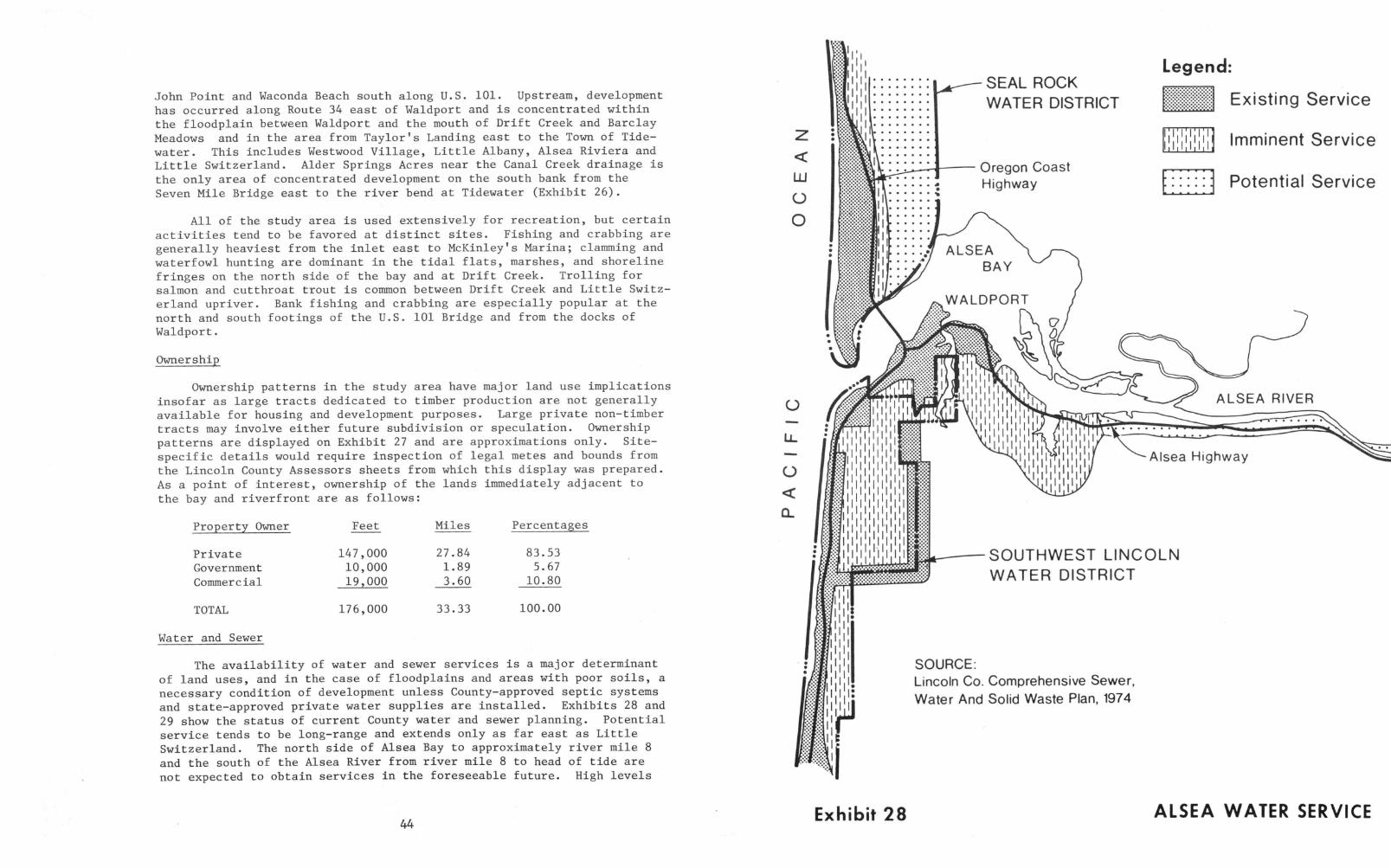
John Point and Waconda Beach south along U.S. 101. Upstream, developmenthas occurred along Route 34 east of Waldport and is concentrated withinthe floodplain between Waldport and the mouth of Drift Creek and BarclayMeadows and in the area from Taylor's Landing east to the Town of Tide-
water. This includes Westwood Village, Little Albany, Alsea Riviera andLittle Switzerland. Alder Springs Acres near the Canal Creek drainage isthe only area of concentrated development on the south bank from theSeven Mile Bridge east to the river bend at Tidewater (Exhibit 26).
All of the study area is used extensively for recreation, but certainactivities tend to be favored at distinct sites. Fishing and crabbing aregenerally heaviest from the inlet east to McKinley's Marina; clamming andwaterfowl hunting are dominant in the tidal flats, marshes, and shorelinefringes on the north side of the bay and at Drift Creek. Trolling forsalmon and cutthroat trout is common between Drift Creek and Little Switz-erland upriver. Bank fishing and crabbing are especially popular at thenorth and south footings of the U.S. 101 Bridge and from the docks ofWaldport.
Ownership
Ownership patterns in the study area have major land use implicationsinsofar as large tracts dedicated to timber production are not generallyavailable for housing and development purposes. Large private non-timbertracts may involve either future subdivision or speculation. Ownershippatterns are displayed on Exhibit 27 and are approximations only. Site-specific details would require inspection of legal metes and bounds fromthe Lincoln County Assessors sheets from which this display was prepared.As a point of interest, ownership of the lands immediately adjacent tothe bay and riverfront are as follows:
Property Owner
PrivateGovernmentCommercial
Feet Miles Percentages
147,000 27.84 83.53
10,000 1.89 5.67
19,000 3.60 10.80
TOTAL 176,000 33.33 100.00
Water and Sewer
The availability of water and sewer services is a major determinantof land uses, and in the case of floodplains and areas with poor soils, anecessary condition of development unless County-approved septic systemsand state-approved private water supplies are installed. Exhibits 28 and
29 show the status of current County water and sewer planning. Potentialservice tends to be long-range and extends only as far east as Little
Switzerland. The north side of Alsea Bay to approximately river mile 8and the south of the Alsea River from river mile 8 to head of tide arenot expected to obtain services in the foreseeable future. High levels
44
0
LL
0
1
.5
SEAL ROCKWATER DISTRICT Existing Service
Legend:
Oregon CoastHighway
'nil1,1,1,1,1,1Imminent Service
Potential Service
ALSEA RIVER
1
1
Exhibit 28
Alsea Highway
-SOUTHWEST LINCOLNWATER DISTRICT
SOURCE:Lincoln Co. Comprehensive Sewer,Water And Solid Waste Plan, 1974
ALSEA WATER SERVICE

BAY TO BAYSANITARYDISTRICT
Oregon CoastHighway
Legend:
Existing Service
Imminent Service
Potential Service
Sewer Outfall
II
I
'II li111111111
ALSEA RIVER
Exhibit 29
SOUTHWEST LINCOLNSANITARY DISTRICT
Alsea Highway
SOURCE:Lincoln Co. Comprehensive Sewage,Water And Solid Waste Plan, 1974
ALSEA SEWER DISTRICTS
of development would require privately installed systems. Present servicein Lincoln County is summarized in Table 28.
Planning and Zoning
By far, the greatest determinants of future development are adoptedland use plans and zoning. Land use patterns are displayed on Exhibit 6in Chapter 1, The Plan Setting, while zoning is shown on Exhibit 30 in thischapter. Land uses compatible with Lincoln County zoning are shown inTables 29 and 30.
Roughly 46 percent of the shorelines within the study area (ex-cluding the ocean beach, Drift Creek, Eckman Lake, Lint Slough and thetidal and marsh islands) is committed to residential and marine residen-tial zoning; nearly 40 percent to natural resource uses, farms, forest andrecreation. The remaining 14 percent is zoned for either rural residen-tial, commercial or marine uses. (See Table 31.) These patterns generallycorrespond to uses recommended in the Alsea Regional Land and Water UsePlan, but local inconsistencies occur at the Bayshore Sandspit, the NorthTerrace, Barclay Meadows and Alder Springs Acres.
The Alsea Regional Plan recommends the following commitments forareas zoned for natural resources uses.
Marshland 521 acres
Marine Waterway(excluding DriftCreek and EckmanLake)
Tidelands
Duneland
TOTAL
1,209 acres (At Mean Tide)
889 acres
301 acres
2,920 acres
Zoning and land use planning recommendations for the Alsea pose aserious problem with respect to future Corps of Engineers permit activi-ties. Most of the south bank of the Alsea to river mile 8 is zoned andplanned for marine residential uses, but conditional uses permitted byLincoln County are such that mobile trailer homes have taken on all of theaspects of permanent residences: patios, driveways, porches, bank stabili-zation and docks. The same condition exists along the north bank fromriver mile 8 upstream to the head of tide. These homes are importanteconomic resources to the Alsea study area and have tremendous social valuefor retirees and others unable to afford higher-priced properties in thefew available upland tracts in Waldport proper or in areas such as Bay-shore. Others are sites of seasonal habitation by visitors who make im-portant economic contributions to the area. Interviews with representatives
45
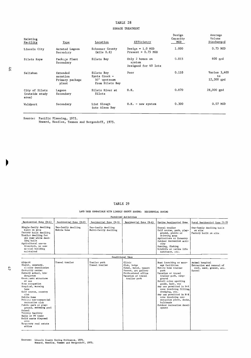
TABLE 28
SEWAGE TREATMENT
Design Average
Existing Capacity Volume
Facility Type Location Efficiency MGD Discharged
Lincoln City Aerated Lagoon Schooner County Design = 1.0 MGD 1.000 0.75 MGD
Secondary (mile 0.8) Present = 0.75 MGD
Siletz Keys Package PlantSecondary
Siletz Bay Only 2 homes onsystem
0.015 600 gpd
Designed for 40 lots
Salishan Extendedaeration
Siletz BaySyota Creek -
Poor 0.110 Varies 3,400to
Primary packageplant
50' upstreamfrom Siletz Bay
12,300 gpd
City of Siletz Lagoon Siletz River at O.K. 0.070 28,000 gpd
(outside studyarea)
Secondary Siletz
Waldport Secondary Lint Sloughinto Alsea Bay
O.K. - new system 0.300 0.07 MGD
Source: Pacific Planning, 1975.Howard, Needles, Tammen and Bergendoff, 1975.
TABLE 29
LAND USES COMPATIBLE WITH LINCOLN COUNTY ZONING: RESIDENTIAL ZONING
Permitted Activities
Residential Zone (R-1) Residential Zone (R-2) Residential Zone (R-3) Residential Zone (R-4) Marine Residential Zone Rural Residential Zone (A-2)
Single-family dwelling Two-family dwelling Two-family dwelling Travel trailer Cne-family dwelling builtbuilt on site Mobile home Multi-family dwelling Golf course, park, play- on site
ractory built dwellingTrailer dwelling for
one year while dwel-ling built
Agricultural use-nolivestock, no comrmercial buildingmaintained
ground, picnic orswimming area
Agriculture or forestryOutdoor recreation acti-vity
Hunting, fishingWildlife or marine life
sanctuary, etc.
Factory built on site
Conditional Uses
AirportChurch, cemetery,
el2rity institutionCo- -unity center
Nursery school, kin-dergarten
Gover.nent structure
Travel trailer Trailer parkTravel trailer
ClinicClub, lodgeHotel, motel, resortMuseum, art galleryProfessional officeVacation or travel
trailer park
Boat launching or moor-age facilities
Mobile home trailerpark
Vacation or traveltrailer park, camp -ground
Animal hospitalExtraction and removal of
rock, sand, gravel, etc.Kennel
or use Retail sales sportingHome occupation goods, bait, etcHospital, Cursing Any use permitted in M-R
home zone involving filling,Golf course, country dredging, etc.
club Any use permitted in M-RMobile,home zone involving con-Private non-commercial
recreation clubstruction piers, docks,bulkheads
Public park or play- Outdoor recreation devel-ground, swimming pool
schoolutility facility
opment
Radio or TV towerSolid waste disposal
areaTemporary real estate
office
Sources: Lincoln County Zoning Ordinance, 1974.Howard, Needles, Tammen and Bergendoff, 1975.
TABLE 30
LAND USES COMPATIBLE WITH LINCOLN COUNTY ZONING: COMMERCIAL ZONING
Permitted Activities
Commercial Zone (C-1) Commercial Zone (C-2) Tourist Commercial Zone (C-T) Marine Commercial Zone (M-C)
Retail store, food, drug, furni-ture, etc.
Auto, truck trailer sales, service,rental
Auto service and repair withinclosed building
Auto serviceBoat launching or moorage
Repair store for retail establish-meats permitted in zone C-1,enclosed building
Boat launching or moorage facilityBoat or marine sales, service,
rental
Barber or beauty shopBoat launching or moorage facilityCar wash
Boat or marine equipment.sales, service,etc.
Manufacture of boats and accessoriesPersonal or business service,
beauty shop, barber, laundry,etc.
Cabinet or woodworking shopCold storage or ice plantFeed or seed store
ClinicClub, lodgeFood score
Multi-family dwellingSingle-familty dwelling built on siteFactory built on site
Clinic Machinery sales, service, rental Gift shop Two-family dwellingFinancial institution Laboratory Hotel, motel, resort Restaurant, bar, tavern
Club, lodge Lumber or building materials Indoor commercial amusement or re- Retail sale of sporting goods, food, etcHotel, motel, resort Machine, welding, metal shop creation establishment Hotel, motel, resortIndoor amusement or recreatiovral Outdoor amusement or recreation Laundromat Cold storage, etc.establishment, bowling alley,theater, etc.
establishmentPlumbing, electrical, paint con-
OfficeMuseum, art gallery
Mortuary tractors, shop Restaurant, bar, tavernNewspaper officeOffice
Processing, packing, storage foodor beverages
Retail sale or sporting goods, bait
Museum, art gallery Tire sales, repair, etc.Restaurant, bar, tavern Truck terminal, freight depot
Upholstery shopWarehouse or storage areaWholesale establishment
Conditional Uses
Vacation or travel trailer parkOutdoor commercial amusement or
recreationSigns, advertising
KennelAnimal hospital
Vacation or travel trailer parkOutdoor recreation activity ordevelopmentAuto repair within enclosed
Mobile homeMobile home trailer parkGovernment structure or useLaboratory
building Open recreation areaSigns, advertising Public park, playground
Public utility facilityVacation or travel trailer parkUse permitted in M-C zone involving
filling, dredging, etc.Use permitted in M-C zone involving
construction of docks, piers, bulk-heads
Source: Lincoln County Zoning Ordinance, 1974.Howard, Needles, Tanmien and Bergendoff, 1975.

TABLE 31
ALSEA BAY ZONING COMMITMENTS
Length of Shorelinea
Zoning Feet MilesPercent inStudy Area
Residential (R-1) 8,500 1.61 4.83
Residential (R-2) 38,000 7.19 21.58Residential (R-3) 8,000 1.52 4.56Residential (R-4) 6,000 1.14 3.42Marine Residential 21,000 3.98 11.94Retail Commercial 0 0
General Commercial 0 0
Tourist Commercial 3,000 0.57 1.71
Marine ComerciLl 7,500 1.42 4.26Natural Resource 70,000 13.25 39.75
Rural Residential 14,000 2.65 7.95
TOTALS 176,000 33.33 100.00
Notes
16,000 feeton ocean
500 feeton ocean
29,000 feeton island
aExcluding Drift Creek, Eckman Lake and Marine Production Area.
Source: Howard, Needles, Tammen and Bergendoff, 1975.
49

er'_vo-
A-2
7.700 50-
A-29
//
A-2
rJ
A-2
r--1 A-2
_1
A-1
I5 IB I1
K
C-2LDPORT 1,022.000
20
ALSEA GENERALIZED ZONING MAP
LEGEND:
RESIDENTIAL:
R-1
R-2
R-3
R-4
M-R
RESIDENTIAL ZONE
RESIDENTIAL ZONE
RESIDENTIAL ZONE
RESIDENTIAL ZONE
MARINE RESIDENTIAL ZONE
COMMERCIAL:
C-1 RETAIL COMMERCIAL ZONE
C-2 GENERAL COMMERCIAL ZONE
C-T TOURIST COMMERCIAL ZONE
M-C MARINE COMMERCIAL ZONE
RESOURCE:
A-1 NATURAL RESOURCE ZONE
A-2 RURAL RESIDENTIAL ZONE
M-W MARINE WATERWAY ZONE
ALSEA HEAD OF NAV/GAT/ON
RIVER MILE II 2
R-229
25+ TIDEWATER A-I
A-1
A-1
LIMIT OF
TIDEWATER
IliL-E-150
M-W
3.5 56 A-1
.20 0 a200 2000 5000 4000 5000
SCALE Or/OREGON
THIS BASE MAP HAS BEEN PREPARED FROM MAPPING SOURCE
OF THE OREGON DIVISION Of STA1E LANDS, THE LINCOLN COUNTY PLANNING DEPARTMENT
LINCOLN COUNTY PLANNING COMMISSION AND THE RENDERED BY PACIFIC PLANNING ASSOCIATES /
U E GEOLOGICAL SURVEY FINES - MARCH 1975
A-I
EXHIBIT 30

of both groups indicate an awareness of flooding and other limitationsimposed by the floodplain. Further, there is a local appreciation forthe natural beauty of the bay and river that served as an attractionfor settlement to begin with, mixed with expressions of concern over over-population and crowding. The narrow upriver portion of the Alsea Rivermore than Alsea Bay proper poses the classic dilemma of estuarine andriverine management: how to accomodate the legitimate interests andneeds of people for close contacts with the "edges" of bays, rivers andlakes while protecting the shoreline characteristics that induced settle-ment to begin with and that are of such concern to the general public.On the Alsea opportunities exist for judicious compromise.
Corps Permits
There is an obvious geographic correlation between patterns of pastshoreline development and areas of intense permit activities. It is ex-tremely difficult, however, to determine the extent to which easy availa-bility of permits has contributed to development of the shoreline andfloodplain. Undoubtedly, the prospect of private docks has been a majorinducement for settlement along the shoreline, but other motivations maybe equally important, e.g., previous settlement by friends and relatives,esthetic qualities and the availability of buildable land.
Since 1971, about 180 permits have been granted for private dockswithin the study area. There is a potential for an additional 180 permitsin the future to serve only those riverfront areas already subdivided butnot yet served by moorage facilities. Further, the Alsea Regional Landand Water Use Plan indicates that the installation of water and sewerservices would open up some 1,500 acres of buildable land, about 300 acresof which are in the floodplain. This suggests that as many as 700 privatedocks may eventually be constructed within the Alsea study area to serviceanticipated and planned levels of development, unless controlled by suchother factors as centralized docking or development restrictions.
Thus far, docks have preempted 20 acres of navigable water withinthe bay and river. At the maximum level of anticipated and planned de-velopment, the preemption would equal roughly 80 acres, or 6.6 percent ofbay and river areas zoned as marine waterways, excluding Drift Creek andEckman Lake. More significant is the extent to which concentrations ofdocks in narrow reaches of the river may cause crowding. (See Table 32.)
Wider reaches of the bay tend to be shallow and contain snags andother obstructions. Boating is concentrated in the deeper, upstreamsections of the river. The convergence of narrow floodplains, which arehigh demand areas for dock construction, therefore, creates the potentialfor a significant conflict with recreational boaters in the narrow channel.The esthetic and social costs of expanding private moorages upstream arebecoming extremely high. To some extent these costs would be mitigatedif undeveloped shorelines planned for low density uses, such as timberproduction and general recreation, were retained in their existing naturalstate.
50

TABLE 32
River Mile Activity
PERMIT ACTIVITY, ALSEA RIVER, 1971-1974
BankProtection
OtherPermits
TotalPermitsYear
ApproximateNumberof Lots
MooragePermits
Dredge/Fill
1.6 Single 1971 1 1 1
2.0 Single 1971 3 1 1
2.1-2.7 None 9
2.7-3.5 Intense 1971-72, 34 12 4 1 4 21few1973-74
3.5-4.5 Scattered 1972 6 2 2 4
4.5-6.0 Intense 1971-72, 55 22 2 2 24
few 1973-74
7.0-7.2 Scattered 1971 1 2 3
Ln 7.5-8.5 Intense 1972, few 41 33 2 4 39
1--, 1971, 73,74
8.9-9.8 Intense 1972, some 63 31 1 1 1 34
1971, 197310.0 Intense 1972, few 22 15 1 16
in 197310.3-10.6 Intense 1972, few 41 28 4 32
197310.9 None 7
11.3-12.0 Intense 1972, 1-1971 27 15 3 18
few 197312.5 Intense 1972 15 8 8
13.5 Intense 1972, few 23 11 11
14.5 None 1973-748
14.8 None 13
TOTALS 368 179 10 4 21 212
Source: Howard, Needles, Tammen and Bergendoff, 1975.

Esthetic degradation due to crowding along the river is not calculable.To some such losses might be regarded as minimal as long as good fishingwere maintained. It is the study team's belief, however, based on apreliminary analysis of the results of the Public Opinion Questionnaire,that to a majority of people who either visit or have located along theriver, the loss would be considered a serious one.
Public comments at the community workshops may provide further in-sights into this question.
Physical Effects
Hydrologically, there is no evidence to support a conclusion thatexisting docks and bank stabilization have altered river flows except totrap silt. This is not to say that bankline modifications may not havesuch effects in the future as riverfronts reach maximum levels of develop-ment. Moreover, debris collection and localized silt deposits aroundpilings have been reported but as with hydraulic effects, an evaluationwould have to be based on site inspection and other analyses beyond thescope of the Wetlands Review.
Dredging and Filling
The advisability of future dredging and filling cannot be totallyresolved within the context of the Wetlands Review. As a minimum, it isthe study team's conclusion that dredging in areas recommended for manage-ment as "wetlands of importance" should not be permitted; further, thatdredging in other locations would only be acceptable to local residents iflimited to removal of snags and silt depositions where they constitutenavigation obstructions to and within the main channel. Specific sitesidentified by the study team include maintenance dredging along the southbank of Alsea Bay from river mile 2 to river mile 3 where local citizensreport that existing docks have been rendered unusable, particularly atlow tide; and between river miles 3.5 and 5 where several marinas andtrailer parks are located.
With respect to future filling, there is a common law presumptionagainst such use of the navigable waters, as discussed in Chapter 1,Plan Setting; but two steps would first have to be taken to resolve this
issue: a) preparation of a comprehensive development plan for the Alseaestuary, identifying potential uses that may require the use of fill andthe availability of alternative upland locations for such uses; and b) ananalysis of the social, biological and economic costs generally associatedwith filling and with the use of piling as an alternative. Factors in-volved would include comparative cost and availability of materials, thesuitability of materials for anticipated uses, public safety, esthetics,and the environmental effects on types of wetlands and upland habitats.
The issue is particularly relevant for certain types of activities:
1. Filling at the Bayshore spit for purposes of bank stabilization.
2. The crossing of McKinney, Lint and Eckman Sloughs with utilitylines such as water and sewer facilities.
3. The need for staging areas in connection with public marina sites.
4. Highway improvements.
5. Conversion of floodplains to intensive land uses such as atriver miles 3.5 to 5.
6. The potential extension of public fishing docks near Waldport.
In one instance, the use of fill instead of pilings has had a nega-tive effect. The obliteration of pilings at the waterfront of "Old"Waldport by landfilling has created difficulties for any plan to restorethe historic flavor of this section of town.
7. EVALUATION AND RECOMMENDATIONS
This chapter presents the major products of the Wetlands Review:
General guidelines and policy and procedural recommendations thathave a direct bearing on the review and issuance of permits by thePortland District.
O A proposed program for management of wetlands of importance.
o A summary of study findings regarding actual or potential activi-ties in functional and geographic areas (Evaluation Units).
A set of specific recommendations to the Corps of Engineerscorresponding to each activity.
These four products were developed through a synthesis of studyfindings and conclusions presented in each of the preceding chapters ofthe report.
POLICY RECOMMENDATIONS
Two difficult problems are inherent in the development of guidelinesand standards for permit decisions in the study area. First, appropriatepermit activities should serve the overall management policy for theestuary. That policy should be manifested in local plans, zoning ordinances,legal restraints and overall objectives as discussed in the Plan Settingand the Land and Water Use Setting. Such elements have been identified andcataloged to the extent possible, but they are not yet organized into acoherent overall plan for the estuary comparable to the comprehensive landuse plan adopted by Lincoln County. Further, implementation of activitiespursuant to such a plan should be a matter of close coordination betweenthe public and every level of responsible government. For these reasons,the study makes the following policy recommendations to the PortlandDistrict:
1. The Portland District should explore with Lincoln County, theMarine Sciences Center at Newport and other appropriate State agencies,the possibility of establishing an estuarine "clearinghouse" within theCounty as tentatively recommended by the Oregon Coastal Conservation andDevelopment Commission. Details concerning the clearinghouse concept arediscussed in Chapter 1. This would facilitate needed interaction andcommunication between levels of government and between government andcitizens in a locally-accessible setting. Future permit activities wouldthen be monitored in light of changing community goals and circumstances.Permit considerations that are difficult to manage, such as esthetics,would be facilitated by competent expertise available through the clearing-house. A board of architectural review is an example.
54
2. The responsibilities of Corps field officers and inspectors shouldbe expanded to include public education and governmental liaison functionsas well as technical assistance, continued field inspection and monitoring.Field officers could function as Corps of Engineers complements to theestuarine clearinghouse discussed above.
3. The Portland District should support and participate in thedevelopment of a comprehensive plan for the estuary as discussed in thePlan Setting. Issues that need to be addressed if permit decisions are tobe consistent with the policies and programs of local and state governmentinclude:
An "action" program for the restoration of the waterfront at "OldWaldport" integrating public uses at the Port of Alsea docks with LintSlough as the most viable small boat marina site within the study area.Because of the economic, historical and social importance of this area,permit applications for major expansion of facilities should only be con-sidered within the context of a publicly supported design for the entirewaterfront area. Otherwise, permit approval for other than routine main-tenance of existing facilities may preempt opportunities and resourcesnecessary for maximum public use and for restoration of the waterfront asrecommended by the Alsea Bay Regional Land and Water Use Plan.
Consideration of two sites as potential dredged disposal locations --the diked area of Lint Slough opposite McKinley's Marina and portions ofthe floodplain adjacent to Route 34 from RM 3.5 to RM 5. Both areas areprivately owned. Fill material is needed for future development plansthat are consistent with local goals; while acceptable disposal sites,which are extremely limited within the study area, may be needed in con-nection with improvements to public navigation.
Consideration of a publicly acceptable program for the removal ofselected and localized silt deposits, snags and other obstructions tonavigation, especially along the south bank of Alsea Bay from RM 2 eastto RM 5. Residential, commercial and recreational uses either exist orare planned for this developing area immediately adjacent to Waldport. Per-mit applications for docks, moorage, and bank stabilization as well as siltremoval are likely to accompany such activities. The following should apply,however:
a. Approval by Lincoln County and the Division of State Lands.
b. Filling should be limited only to that needed for bankstabilization.
c. Activities should not encroach on McKinney Slough or the mouthof Eckman Slough, which are wetlands of importance. In this respect,the recommendation of the Alsea Bay Regional Land and Water Use Planfor marina development near both sites should be reevaluated to avoidadverse spill-over effects on the sloughs. Piling should be used inpreference to fill where this is viable.
55

The desirability or need to recognize the "oyster house" as apotential historic site. Future permit applications for restoration orremoval of its substructure in Alsea Bay could then be evaluated with dueconsideration to its historic significance. The lines of abandoned pilingsat Sheppard Point on the north side of Alsea Bay and west of the "oysterhouse" adjacent to Route 34 should be similarly considered. However,bottom samples should be taken in connection with any proposal for removalof these pilings to determine if the bottom sulfides are sufficientlygreat to cause major water pollution problems.
The need for measures to protect as much of the remaining marsheast of Eckman Lake as possible. Existing and future filling is in con-flict with the biological value and flood absorption capability of themarsh. In view of the economic importance of this area for planned marinaand recreational development, a line should be established (near Mean Hightide and acceptable to riparian owners and State agencies) beyond whichfurther filling and diking should not occur.
Consideration of public access laterally along the waterfrontwherever possible. Use of interconnecting docks, boardwalks and otherfacilities on pilings may be of social and economic benefit to both usersand marinas where such facilities are near or contiguous to each other.Private property should be exempt from easements for such access exceptby consent of riparian owners.
The need for alleviating the water quality problem caused by dikingin the North Channel, including modification of the existing dike to pro-vide for tidal flushing and salmon migration.
The need to eliminate the likely effects of marine residentialzoning in the undeveloped floodplain adjacent to Route 34 between RM 5.5and RM 8. Based on experiences elsewhere within the study area, marineresidential uses would involve extensive filling and occupation of thefloodplain and a major increment in new private moorages in this narrowreach of the river. In the absence of detailed site development plansfor the area, or other measures to mitigate such effects, denial of permitapplications in contravention of planned uses would be warranted.
Consideration of alternatives to the development of waterfrontfacilities and structures at the Bayshore spit. Applications for thestabilization of the spit should ordinarily be subject to an environmentalimpact statement due to high esthetic value and the potential for inter-ference with natural erosion processes. Some activities, such as the pro-vision of public access over the dredged canal, may be considered aspossibilities without the need for such detailed evaluation.
Continued liaison with the Port of Alsea concerning sponsorshipand local financing of groins and jetties at the inlet. Should that pro-ject prove economically feasible, the procedures inherent in the NationalEnvironmental Policy Act guarantee opportunities for public involvement in
56
such a decision as well as technical environmental evaluation. An environ-mental impact statement under the Act should be prepared in view of thefact that consensus on the desirability of the project may not exist.
PROCEDURAL RECOMMENDATIONS
The second difficulty associated with the establishment of standardsand criteria is that a single set of rules is not adequate for eachsituation likely to occur in a diverse, complex and changing estuarineenvironment. Both the structure and application of standards should beflexible and to an appropriate extent supportive of changing local goalsand objectives.
In addition, when Oregon's Coastal Zone Management program is approved,the Portland District will have to reevaluate its own policies and pro-cedures to ensure as much consistency as is possible in the management ofsubmerged and submersible lands and water of the estuary. The study hasaccounted for and, in fact, draws on many facets of OCC&DC's work; butsome of the issues that were involved in OCC&DC's dialogue with local andState government will need to be clarified in the continuing relationshipsbetween State and Federal agencies. The issues of fill vs. piling, andrestrictions on further fill discussed throughout the Plan Setting andLand and Water Use Setting are examples. In the interest of consistency,however, two recommendations are made at the outset.
1. The Portland District should explore with the Division of StateLands and Lincoln County (including Oregon's coastal zone managementagency when approved) the possibility of instituting a uniform permitapplication form. The form should meet the needs of potential applicantsfor clarity as well as the requirements of the agencies. Provisionsshould be made for appropriate sign-offs by reviewing agencies to elimi-nate the applicant's need to provide duplicate information and materials.The form should also provide for a differentiation between types ofactivities, i.e., public or private marine; and use a standardizedsystem for the location of proposed permit activities; i.e., uniformriver miles.
2. Internal procedures for the consideration of permits should re-flect the nature of the proposed work and the severity of potential effects.It is doubtful, for example, that public notices on many classes of permits(permits for repair of existing facilities, for example) serve a usefulpurpose. On the other hand, permit applications for new private mooragesin areas currently zoned for marine residential uses should be held andevaluated at regular six-month intervals so that the cumulative impact ofnew facilities, including alternative means of providing such moorage, canbe evaluated.
57

WETLANDS OF IMPORTANCE
In accordance with current regulations, "wetlands of importance tothe public interest" are defined as those marshes, eelgrass beds, clambeds,tideflats and other areas regularly inundated by the ebb and flow of thetide having high biological, recreational, esthetic and social values.Biological criteria used in recommending wetlands in the study area werehigh productivity, high species diversity, low levels of disturbance, lowresilience, uniqueness, and functional ecosystem importance.
Social, recreational, esthetic as well as economic factors were alsoconsidered in recommending such areas, but undoubtedly further suggestionswill be offered in the comments of State agencies, universities, privatecitizens and organizations involved in the community participation aspectsof this program. Additional input will be forthcoming when the results ofthe public opinion questionnaire are analyzed.
Wetlands of importance shown on Exhibit 5 in the Introduction include:
*Clambeds and tideflats on the inside of Bayshore spit andnortheast along the base of the north terrace.
*Tideflats, marshes, eelgrass and clambeds in the northernportions of the bay, southeast to, and including, thecentral tideflats, marsh island, and marshes of Drift Creek.
*Marshes and tideflats of middle Lint Slough, south of Route 34.
*McKinney Slough.
*Tideflats and marshes at the mouth of Eckman Slough, northof Route 34.
1. Within these "wetlands of importance" permit applications in-volving the following types of activities should ordinarily be denied:
*dredging
*filling
*damming or diking
*bulkheads or riprap
*removal of pilings, driftwood, log debris, sediments
*all terrain vehicle use
*aquaculture, if it involves alteration of the wetlands or deniespublic uses thereof
58Alt
*causeways on fill
*channelization
*draining
*sewage, refuse or spoil disposal
*piers/docks/marinas
*overhead or submerged utility lines
2. Allowable activities include:
*fishing for sport
*collecting bait
*recreational clamming and crabbing
*hunting (and temporary duckblinds)
*shallow draft boating
*birdwatching and photography
*scientific collections and research
*educational field trips
*wildlife refuges
*marine production (except aquaculture involving significantalteration of the environment or that preempt public uses)
*open space (visual and real)
3. Where social or economic factors appear to be sufficiently jus-tified, any of the above activities should be subjected to an environmentalimpact statement or assessment, whereby the following are evaluated:
*Public benefit of the proposed activity vs. the loss of the wetlandresource.
*The necessity of the proposed activity to realize these publicbenefits.
*Feasible and prudent alternatives to loss of the wetlands resource.
*Primary and secondary impacts.
59

The basis for these recommendations are discussed in the "PublicTrust" section of Chapter 1, the Plan Setting. The overall approachdiffers from that usually applied in the management of preservation areas,of "wilderness" for example. In view of the fact that many of the wetlandsare privately owned and their future use is unpredictable, flat prohibi-tion against all use could represent condemnation without due process.
4. Some activities may have negative impacts on wetlands of importancewherever they occur. In such instances detailed environmental assessments,related especially to the biological and hydrological impacts on the wet-lands, should be conducted if there is reason to believe they will alterflushing characteristics and circulation of water; change salinity, temper-ature, or clarity of water; result in discharges of toxic substances ormaterials with excessive nutrient content; change the volume or rate offresh water inflows; result in heavy sedimentation; or reduce high levelsof dissolved oxygen within the estuary.
Applicable examples are:
*Major dredging in the channel for navigation
*Expansion, construction and repair of transportation corridors
*Major industries
*Water withdrawal/diversions
*Resource extraction
*Outfalls and disposal
*Tidegates
*Groins/jetties
*Bridges
*Upland developments with canals
*Utility crossings
5. The remaining tidelands and beaches not recommended at wetlandsof importance as well as the main channel also have significant biological,esthetic and recreation values recognized by local zoning and by Stateagencies. The preceding standards should apply to these areas as well.
AREAS OF ENVIRONMENTAL CONCERN
Areas of environmental concern are essentially of two types:
° Those falling within the direct jurisdiction of the Corps ofEngineers by virtue of the fact that they are actually below the line ofMean Higher High Water or historically below the line of Mean Higher HighWater. The latter includes diked pastures, reservoirs or filled landscreated by alterations to the "navigable waters" as defined by survey.This interpretation is possible since only Congress itself can declarea body of navigable water or portion thereof "non-navigable." In essence,conversion of the navigable waters to other uses through diking, land-filling and similar activities, does not extinguish the Federal navigationservitude running with such properties. Again, such servitude can only beextinguished by Congress itself.
° Those falling within the responsibility of the Corps of Engineersif not its jurisdiction by virtue of the fact that permit activities inthe navigable waters may have general adverse effects on shorelines, flood-plains and uplands above the line of Mean Higher High Water.
The range of effects which the Corps must consider include esthetics,land use, socioeconomic, public safety and environmental impacts.
Within the study area, the following recommendations deal mostappropriately with anticipated permit effects.
Esthetics
Permit applications in select locations identified in the WetlandsReview study should be carefully reviewed to ensure that they do not in-trude on highly esthetic backdrop for the bay and river. These locationsinclude:
*The Bay, beach and cliff of the North Terrace
*Areas recommended as wetlands of importance
*Drift Creek
*The north bank of the Alsea River east of Drift Creek to BarclayMeadows
*The high steeply-sloped portions of the south bank of the AlseaRiver immediately west of the 7 mile bridge
*Except for Alder Springs Acres, the south bank of the Alsea Riverfrom the 7 mile bridge to the head of tide
These recommendations are consistent with local planning and zoningrequirements and recognize slope and other development limitations.
For permit activities in remaining areas, the options for estheticconsideration range from preparation of impact statements; use of pro-fessional architectural services; application of OCC&DC's design and landuse prescriptions; to application of Lincoln County ordinances for scenicroadways and corridors. The most feasible means to ensure integration ofthese various esthetic standards is the institution of local architecturalreview boards in connection with the establishment of estuarine clearing-houses recommended by OCC&DC.
Land Use
Permit activities should not contravene locally adopted master plansfor orderly growth and for the provision of public services; and to theextent possible should support levels of natural resources protection,public safety and well-being inherent in zoning and in developmentstandards and ordinances. Permit activities in the following areaspotentially conflict with this principle:
*On the North side of Alsea Bay at Bayview; on Drift Creek; in theundeveloped portions of Barclay Meadows and Alder Spring Acres.
*In other areas planned or zoned for natural resource uses (farm,forest or recreation).
*In new riverfront subdivisions. Lincoln County ordinances statethat new subdivisions having less than 10 moorage spaces will be approvedonly in the instance that public or private means of launching or moorageare available or can be developed within 1,000 feet of the site in question.
It is recommended that new private moorage not be allowed for sub-divisions of any size where public or private moorage is available or canbe developed within 1,000 feet of the site in question with the followingexceptions:
*Moorage for lots already privately owned or occupied but withoutsuch facilities; or
*Moorage for lots already subdivided but unoccupied where lotsimmediately adjacent have such facilities.
The intent of the recommendation is to require serious considerationof providing and using alternatives to the proliferation of private dockswithout disrupting current plans for capital investment; without diminish-ing the full use and enjoyment of sites already purchased or occupied byprivate owners; and without placing inevitable burdens on prospectiveowners in existing subdivisions.
EVALUATION UNITS AND RECOMMENDATIONS
The following material, organized by Evaluation Units, attempts todeal with all of the foregoing circumstances and to detail other possibili-ties for distinct areas within the study area. A brief chart summarizesthe principle uses, esthetic importance, biological value, socioeconomicsignificance and physical nature of environmental conditions found withineach unit shown on Exhibit 33.
Items listed as actual/potential are those the study team hasidentified as either occurring or likely to occur. They are based on thefindings of each chapter in the report and include formal and informalpolicies and programpor simply suggestions by the general public.
The activities in some cases represent choices that may be mutuallyexclusive, and they are presented to illustrate the range of optionsavailable to those responsible for management of the study area. Manyaffect but are not within the direct responsibility of the PortlandDistrict.
Corresponding to each activity is a "recommendation" to the PortlandDistrict. These recommendations show potential Corps reactions to permitapplications emanating from the actual or potential activity.
This section of the report is preliminary, pending further commentsand suggestions by the Portland District, reviewing agencies and thegeneral public. Following an analysis of the public opinion questionnaireand in light of comments and suggestions received during the formalcommunity participation aspects as the study program, study findings andrecommendations will be reevaluated and reorganized as appropriate.
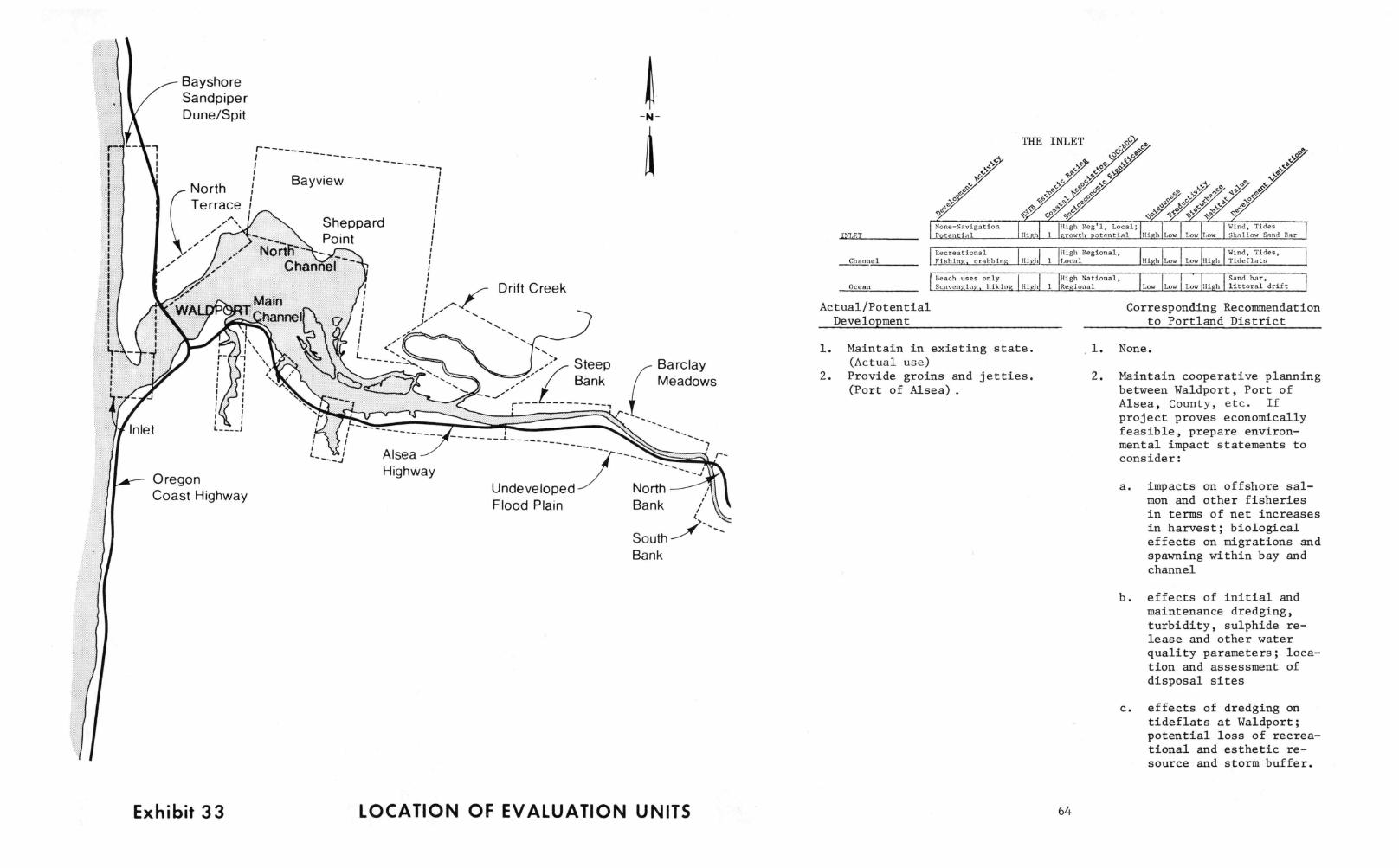
BayshoreSandpiperDune/Spit
North iitTerrace 1
r_
Bayview
SheppardPoint
Drift Creekg
r-1 Steep
BankBarclayMeadows
---------Inlet
OregonCoast Highway
Exhibit 33
L
AlseaHighway
r-
UndevelopedFlood Plain
NorthBank
SouthBank
LOCATION OF EVALUATION UNITS
INLET
ChannelRecreationalFishing, crabbing 'High' 1
Beach uses only I
Ocean Scavenging, hiking High 1
Actual/PotentialDevelopment
ys
doac
Oe
None-NavigationPotential
THE INLET
High
20C'
No
otiy9 Esc
6ti
c'e',/pe:/./Vec:///06)
e.
e N'5' 4°
OC'
(High Reg'1, Local;1 `growth potential High Low Low Low
Wind, TidesShallow Sand Bar
High Regional,Local High Low Low High
Wind, Tides,Tideflats
High National,Regional Lo Lo Low High
Sand bar,littoral drift
1. Maintain in existing state.(Actual use)
2. Provide groins and jetties.(Port of Alsea) .
64
Corresponding Recommendationto Portland District
1. None.
2. Maintain cooperative planningbetween Waldport, Port ofAlsea, County, etc. If
project proves economicallyfeasible, prepare environ-mental impact statements toconsider:
a. impacts on offshore sal-mon and other fisheriesin terms of net increasesin harvest; biologicaleffects on migrations andspawning within bay andchannel
b. effects of initial andmaintenance dredging,turbidity, sulphide re-lease and other waterquality parameters; loca-tion and assessment ofdisposal sites
c. effects of dredging ontideflats at Waldport;potential loss of recrea-tional and esthetic re-source and storm buffer.

65
Corresponding Recommendationto Portland District
d. overall esthetic impact:inlet is cited in OCC-6,DC's Visual Aspect reportas providing opportunitiesfor "exceptional estheticexperiences"
e. extent to which north andsouth jetties would inter-rupt littoral drift ofsand supplies to Bayshorebeach and beaches southof inlet
f. extent to which oceanwaters may be deflectedinto Yaquina John Pointwhere erosion is occurring
g. extent to which develop-ments would result in oraccelerate major land usechanges in Waldport; dis-placement of low and mod-erate income housing;socio/economic effects onlocal governmental servi-ces, utility and transpor-tation infra structureimprovements, net changesin employment, income andtax base
h. community attitudes re-garding a marked change inthe character of Waldport.
RAYSHOPF SPIT
Beach/dune
Tideflat
Woodlands
Man - dominated
BAYSHORE SPIT
Subdivided, homesCommercial uses High
ti
wg
Moderate Local1 growth potential
Critical OceanErosion; high water
RecreationSeasonal homes MO' 1
High local,Moderate Regional High Low High
Hind, WaterLow State Beach
Clamming, FishingBeach Recreation High 1
High LocalHigh Mod. Low High
Submerged /zoning,Submersible Lands
Commercially ZonedOpen Space
Moderate LocalHigd 1 Low 'Mod High
Unstable SoilsMod. High Water Table
IService Roads,Motel, homes, canal
Actual/PotentialDevelopment
High 1Moderate local
Mod. Low High LowBay Side ErodingHigh Water, Storms
Corresponding Recommendationto Portland District
1. Continue to develop dune and spit 1. None.for single family and commercialuse; provide sewer and water.(Zoning, Actual Use)
2. Manage as duneland as recom-mended in Alsea Regional Plan;purchase properties; restrictdevelopments to clusterings onhigher grounds. (General Public)
3. Maintain ocean beach for publicrecreation; provide additionalpublic access. (Zoning, AlseaRegional Plan, OCC&DC, State)
4. Recognize south end of sandspit as habitat for endangeredsnowy plover. (WetlandsReview, State)
5. Maintain bayfront tidelandsfor public recreation. (Gen-
eral Public)
66
2. None.
3. Coordinate permits for commer-cial sand and driftwood re-moval with Division of StateParks.
4. Verify plover habitation inconnection with proposals formodification of spit.
5. Ensure public access acrossthe length of the beach;approve crossover at mouth ofcanal.

Actual/PotentialDevelopment
6. Open canal for marina development.(General Public)
7. Stabilize eroding bayside of spit.(General Public)
8. Maintain value of clam beds ingravel beach and adjacent tomain channel. (State, WetlandsReview, General Public)
Corresponding Recommendationto Portland District
6. Assess potential for dunebreaching; assess theeffect of concentratingvessels in the canals onwater quality.
7. Assess
a. visual/ estheticimpacts
b. cost/effectiveness
c. desirability of publicexpenditure
d. navigation effects onmain channel
e. hydrologic change inbay/transport of ero-sion problem to theterrace and footingsof the U. S. 101bridge
f. effects on adjacentclam beds
g. effects on public re-creation; fishing,clamming, collecting.
8. Manage as a "wetlands ofimportance."
Actual/PotentialDevelopment
Corresponding Recommendationto Portland District
9. Develop waterfront recreational/ 9. Assessmarine commercial complex. (AlseaRegional Plan, Zoning) a. visual/esthetic impacts
b. navigation effects onmain channel
c. requirements for bankstabilization
d. provision of public assess
e. integration of facilitywith commercial complexon dune/Bayshore Motel
f. effects on adjacent clambads as a "wetlands ofimportance."
g. increased breach potential
10. Maintain/improve existing boat 10. Condition permit to ensurelaunching facilities. (Actual "shore-type" character (no
Use) extension of docks, piers,and other structures into themain channel).

WALDPORT(Excluding Old Waterfront and Lint Slough)
WALDPORT
Town of 700Mixed Res/Comm Mod.
Ic'O////CP//: 177
* tiv
e eramo<s° q/1"
cf- 4z. e 4-°
'High local,
2 'Moderate Regional
Tax Rase, PoorCapitalization
Highway 101
Man-dominated High Tourist Use
Tideflat
!Mod.] 2
High Local; Mod.,Reglonal Potential Mod. Low High
Stable Flood PlainLow I Steep Slopes
Clamming, FishingBeach Recreation High! 1
High LocalMod. Low 1od. Mod.,
Submerged; zoningSubmersible Land
Actual/PotentialDevelopment
Corresponding Recommendationto Portland District
1. Encourage moderate development of 1. None.bay; maintain balanced mix of uses;discourage strip development; pro-tect small town flavor; increaseeconomic potential and public ser-vices; maximize tourist facilitiesand opportunities; restore "Old"town. (Zoning, Alsea's WaldportPlans, General Public, OCC&DC)
2. Develop bay waterfront as a parkwhen residential housing becomesvacant; integrate with commer-cial development along U. S.101; consider boardwalk, fishingpier, trailer and auto parking;shore-type boat launching faci-lities. (Alsea Regional Plan-Informal,General Public)
2. Condition permits to avoid orminimize disruption of tide-flats and bay beaches as re-creational, esthetic, biolo-gically important resources,(shorebirds, shrimp, crabs,flounder); ensure accessibi-lity for young, infirmed andelderly; utilize pilings andwood structures in lieu ofsolid fill; minimize disrup-tion of residential neighbor-hood; include public partici-pation in reviewing plan;maintain bank/beach stability.
Actual/PotentialDevelopment
Corresponding Recommendationto Portland District
3. Assemble large tracts of shoreline 3.
property for high density commer-cial/retail/tourist development.(General Public)
4. Locate boat marina on north-eastern end of tideflat. (Portof Alsea)
Same as above; ensure compati-bility with Alsea RegionalLand and Water Use Plan andLincoln County zoning.
4. Same as above. Proposalwould involve major dredgingand diking of the tideflat.(Proposal has apparently beenmade moot by Port of Alseasupport for marina develop-ment at Lint Slough).
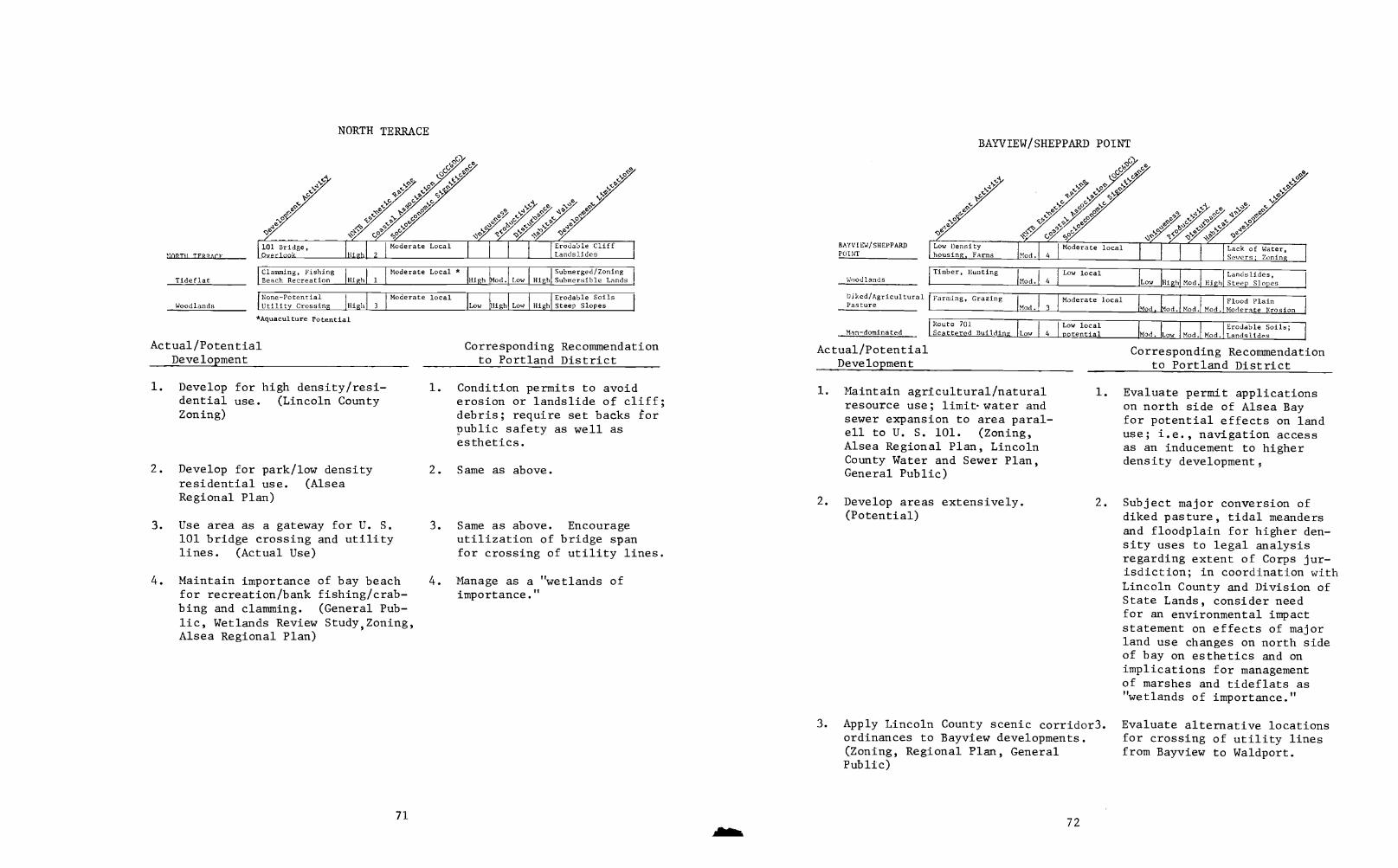
as
[101 Bridge,NORTH TFR/ArF Overlook
Tideflat
Woodlands
ti
NORTH TERRACE
C,
High 2
Moderate Local Erodable CliffLandslides
Clamming, FishingBeach Recreation High 1
Moderate Local *High Mod. Low
Submerged /ZoningHigh Submersible Lands
None-PotentialUtility Crossing High 3
Moderate localLow High Low High
Erodable SoilsSteep Slopes
*Aquaculture Potential
Actual/PotentialDevelopment
1. Develop for high density/resi-dential use. (Lincoln CountyZoning)
2. Develop for park/low densityresidential use. (AlseaRegional Plan)
3. Use area as a gateway for U. S.101 bridge crossing and utilitylines. (Actual Use)
4. Maintain importance of bay beachfor recreation/bank fishing/crab-bing and clamming. (General Pub-lic, Wetlands Review Study,Zoning,Alsea Regional Plan)
71
Corresponding Recommendationto Portland District
1. Condition permits to avoiderosion or landslide of cliff;debris; require set backs forpublic safety as well asesthetics.
2. Same as above.
3. Same as above. Encourageutilization of bridge spanfor crossing of utility lines.
4. Manage as a "wetlands ofimportance."
BAYVIEW/SHEPPARDPOINT
Woodlands
Diked/AgriculturalPasture
Man-dominated
Actual/PotentialDevelopment
BAYVIEW/SHEPPARD POINT
Low Densityhousing, Farms
Timber, Hunting
Mod.
Mod.
I Moderate local4 I
4
Low local
Lack of Water,_Sewers; Zoning
Landslides,Steep Slopes
Farming, Crazing I
Mod. 3
Moderate localMod. .Mod. Mod. Mod.
Flood PlainModerate Erosion
Route 701Scattered Building Low 4
Low localpotential
1. Maintain agricultural/naturalresource use; limitwater andsewer expansion to area paral-ell to U. S. 101. (Zoning,Alsea Regional Plan, LincolnCounty Water and Sewer Plan,General Public)
2. Develop areas extensively.(Potential)
Mod. Low Mod. Mod.Erodable Soils;Landslides
Corresponding Recommendationto Portland District
1. Evaluate permit applicationson north side of Alsea Bayfor potential effects on landuse; i.e., navigation accessas an inducement to higherdensity development,
2. Subject major conversion ofdiked pasture, tidal meandersand floodplain for higher den-sity uses to legal analysisregarding extent of Corps jur-isdiction; in coordination withLincoln County and Division ofState Lands, consider needfor an environmental impactstatement on effects of majorland use changes on north sideof bay on esthetics and onimplications for managementof marshes and tideflats as"wetlands of importance."
3. Apply Lincoln County scenic corridor3.ordinances to Bayview developments.(Zoning, Regional Plan, GeneralPublic)
72
Evaluate alternative locationsfor crossing of utility linesfrom Bayview to Waldport.
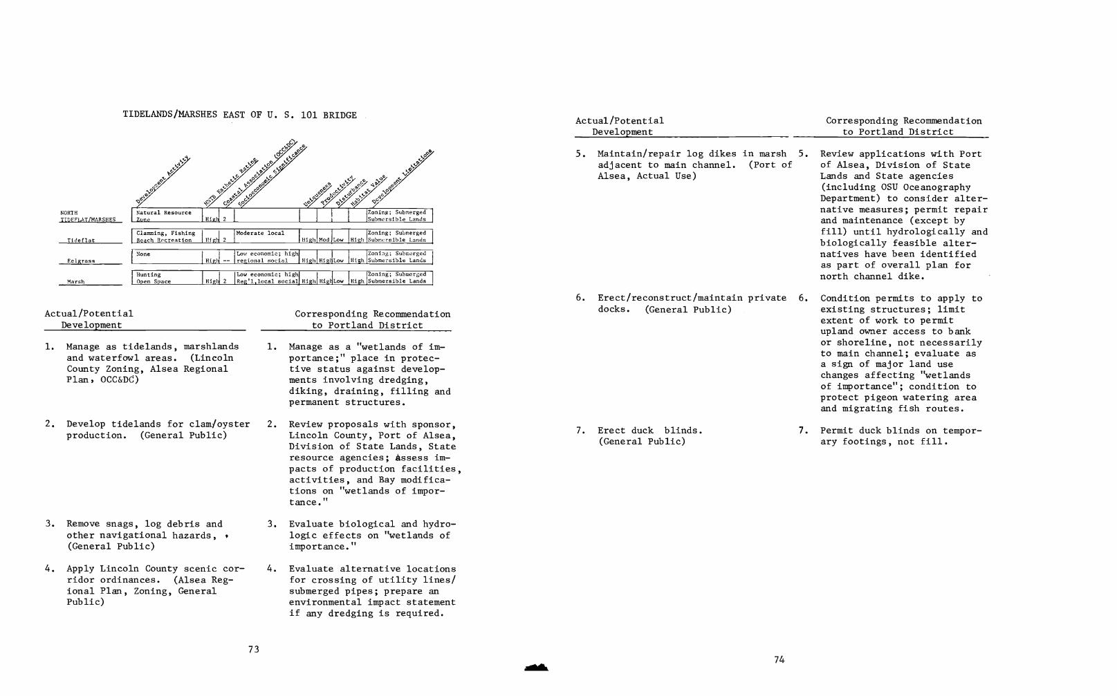
NORTHTIDEFLAT/MARSHES
Tide flat
Eelgrass
Marsh
TIDELANDS/MARSHES EAST OF U. S. 101 BRIDGE
cO'
44' cFP4' 4' P
CP c.,P
2 1
so
tis
Natural ResourceZone Higl-
Zoning; SubmergedSubmersible Lands
Clamming, FishingBeach Recreation 111g1- 2
Moderate localHigh Mod Low High
Zoning; SubmergedSubmersible Lands
NoneHigl-
Low economic; highregional social High Hig Low High
Zoning; SubmergedSubmersible Lands
HuntingOpen Space
Low economic; highHigj 2 IReg'1,1ocal social HighlHigl Low High
Zoning; SubmergedSubmersible Lands
Actual/PotentialDevelopment
Corresponding Recommendationto Portland District
1. Manage as tidelands, marshlands 1. Manage as a "wetlands of im-and waterfowl areas. (Lincoln portance;" place in protec-County Zoning, Alsea Regional tive status against develop-Plan, OCC&D6) ments involving dredging,
diking, draining, filling andpermanent structures.
2. Develop tidelands for clam/oysterproduction. (General Public)
3. Remove snags, log debris andother navigational hazards,(General Public)
4. Apply Lincoln County scenic cor-ridor ordinances. (Alsea Reg-ional Plan, Zoning, GeneralPublic)
73
2. Review proposals with sponsor,Lincoln County, Port of Alsea,Division of State Lands, Stateresource agencies; Assess im-pacts of production facilities,activities, and Bay modifica-tions on "wetlands of impor-tance."
3. Evaluate biological and hydro-logic effects on "wetlands ofimportance."
4. Evaluate alternative locationsfor crossing of utility lines/submerged pipes; prepare anenvironmental impact statementif any dredging is required.
Actual/PotentialDevelopment
Corresponding Recommendationto Portland District
5. Maintain/repair log dikes in marsh 5. Review applications with Portadjacent to main channel. (Port of of Alsea, Division of StateAlsea, Actual Use) Lands and State agencies
(including OSU OceanographyDepartment) to consider alter-native measures; permit repairand maintenance (except byfill) until hydrologically andbiologically feasible alter-natives have been identifiedas part of overall plan fornorth channel dike.
6. Erect/reconstruct/maintain private 6. Condition permits to apply todocks. (General Public) existing structures; limit
extent of work to permitupland owner access to bankor shoreline, not necessarilyto main channel; evaluate asa sign of major land usechanges affecting "wetlandsof importance"; condition toprotect pigeon watering areaand migrating fish routes.
7. Erect duck blinds.(General Public)
74
7. Permit duck blinds on tempor-ary footings, not fill.

TIDEFLATS ADJACENT TO WALDPORT AND U. S. 101 BRIDGE
WALDPORT
Man-dominated
Tideflat
yo
4°qe
e e4a yac
c0!''
ere
tia
e,ef
Town of 700Mixed Res/Comm Mod.
High local,2 Moderate Regional
Tax Rase, PoorCapitalization
Highway 101High Tourist Use Mod. 2
High Local; Mod.Regional Potential Mod. Low High Low
Stable Flood PlainSteep Slopes
Clamming, Fishing
Beach Recreation High 1
High LocalMod. Low hod. Mod.
Submerged; zoningSubmersible Land
Actual/PotentialDevelopment
1. Dredge in connection with open-ing inlet.
2. Manage as tidelands. (AlseaRegional Plan, Lincoln CountyZoning)
3. Repair/maintain/replace footingsfor U. S. 101 Bridge.
75
Corresponding Recommendationto Portland District
1. Consider dredging in an envi-ronmental impact statement onopening of inlet.
2. None
3. Condition permit applicationsfrom Oregon Highway Depart-ment to ensure evaluation ofhydrologic effects on bayi.e., maintenance of tidalflow, patterns and currents;adequate pier spacing; dis-posal of dredged spoil inapproved site.
MAIN CHANNEL
Channel
River
MAIN CHANNEL
Q?Syr °r *
4' /5' /oe'c'6C'°e
Marine RecreationHigh,
High Local. and
2 I Regional
WaterwaySilt/Snags
Fishing, Crabbing,Boating High 2
High Local andRegional High Low Low High
Silt/SnagsNarrow Channel
Fishing, Marinas I
homes, docks,pilingillighi 3
High Local andRegional High Low I Low High
Narrow Channelheavy use
Actual/PotentialDevelopment
1. Maintain as marine waterway.(Zoning, Alsea Regional Plan,State, Federal, General Public)
2. Protect and enhance fisheries/spawning, habitat, migration.(State, Federal, General Public)
3. Locate marinas, marine recrea-tional and marine-oriented retailfacilities; maintain/improve liva-bility and economy of study area.(Zoning, Alsea Regional Plan,OCC&DC, State, General Public)
76
Corresponding Recommendationto Portland District
1. Maintain navigability andother values as "public trust";implement Wetlands Review;monitor and revise as needsand conditions require.
2 Maintain vegetated banklineswhere possible; generallyprohibit dredging, filling,diking and damming except atspecific locations identifiedin Wetlands Review and incoordination with the Divisionof State Lands, State agencies,Lincoln County and Port ofAlsea. Permit applicationsare submitted to U. S. Fishand Wildlife Service and NOAAfor comment.
3. Locate at areas recommended inAlsea Regional Plan exceptwhere navigation and biologi-cal values conflict; supportpreparation of Alsea EstuaryPlan.

Actual/PotentialDevelopment
4. Protect/enhance water quality.(State, Federal, General Public)
Corresponding Recommendationto Portland District
4. Coordinate permits for dis-charges with the U.S. Environ-mental Protection Agency andState Department of EnvironmentalQuality for compliance withwater quality standards.
5. Discourage proliferation of docks/ 5. Limit permits for privateutilize clustered facilities. moorage to areas and under(Alsea Regional Plan) conditions recommended in
Wetlands Review for particularriver bank areas.
6. Maintain flow in south rather than 6. Permit repair and maintenancein north channel. (Port of Alsea, of existing dikes until hydro-General Public) logically and biologically
feasible alternatives areidentified; review permitapplications by Port of Alseafor repair/maintenance ofdikes in north channel withPort of Alsea, Division ofState Lands and State agencies(including OSU OceanographyDepartment) for considerationof alternative measures andenvironmental assessment.
7. Dredge silt depositions/removesnags. (Port of Alsea, GeneralPublic)
77
7 Limit silt and snag removal toselect river areas where theyconstitute proven hazards/obstructions to recreationalnavigation; identify specificsites in advance in coopera-tion with Port of Alsea,Lincoln County, Division ofState Lands and other Stateagencies as recommended inWetlands Review.
Actual/PotentialDevelopment
8. Protect esthetic quality ofriver zone as a scenic corridor.(Zoning, Alsea Regional Plan,OCC&DC, U. S. Forest Service,General Public)
ae
Corresponding Recommendationto Portland District
8. Evaluate alternative sitesfor proposed river crossingsand shoreline developments inareas with high estheticratings; condition permits toensure compliance of OCC&DCdesign recommendations withLincoln County scenic corridorordinances and U. S. ForestService standards.
NORTH CHANNEL
Diked; Fishing,NORTH CHANNEL Hunting Mod. 2
Moderate Local
Actual/PotentialDevelopment
Same as MAIN CHANNEL with followingexceptions:
78
WaterwayMod. Mod. Mod Mod. Obstruction
Corresponding Recommendationto Portland District
1. Dredging has potential formajor disruption of adjacenttidelands and marshes that arerecommended for management as"wetlands of importance."Conduct a detailed hydrologicand biological assessment.
2. Water quality deterioration inthe north channel is caused byinadequate flushing. Discusspossibility of installingculvert or piers as modifica-tions to or total removal ofexisting dike with Port ofAlsea and State agencies;preferably, consider alterna-tives to dikes as previouslydiscussed.

DRIFT CREEK
River
Diked/AgriculturalPasture
Woodlands
DRIFT CREEK
, tiny
latural Resource
Zone
Mod. local Econ.;high local social
Zoning; Water,Sewer, Roads
Fishing, Hunting,Boating High
Mod. economic;high social
Submerged Land,Narrow channel
Farmstead; GrazingIMod. 4
Low localMod. Mod Mod.
Floodplain
Timber Production 'Moderate localHigh! 4 Low l Mod Mod. High
Slopes; ErodableSoils
Actual/PotentialDevelopment
1. Maintain agricultural, naturalresource use of watershed; donot extend water, sewer orother public services, in-cluding transportation improve-ments. (Zoning, Alsea RegionalPlan, Lincoln County Water andSewer Plan, U. S. Forest Service;General Public)
2. Protect open space and semi-wildesthetic character of watershed.(Zoning, Alsea Regional Plan,U. S. Forest Service, GeneralPublic)
3. Allow recreational developmentas a variance of Lincoln Countynatural resource zoning.(Alsea Regional Plan,Zoning)
79
Corresponding Recommendationto Portland District
1. Evaluate permit applicationsfor potential effects on landuse changes, i.e., navigationdevelopment as an inducementto more intense land uses;limit moorage.
2. Evaluate alternative sites forproposed channel crossings andother shoreline developments;condition permits to ensurecompliance with OCC&DC designrecommendations and LincolnCounty zoning and scenic cor-ridor ordinances.
3. Review permit applications formarine recreation in lowerwatershed for potential toopen up entire watershed forintense development; evaluatewith Lincoln County, appli-cant, State agencies and U. S.Forest Service.
Actual/Potential Corresponding RecommendationDevelopment to Portland District
4. Consider watershed as potential 4. Permit no activities thatcandidate for public acquisition, would pre-empt possible(Alsea Regional Plan) acquisition, i.e. extensive
private moorages.
5. Maintain tide gates and dikes for 5. Restrict applications toexisting agricultural use of flood- repair/maintenance of existingplain. (Actual Use) gates and dikes; limit exten-
sions to prevent destructionof tidal meanders and remain-ing marshes; subject applica-tions for major filling ofdiked lands below the MeanHigh Tide to analysis of Corpslegal jurisdiction.
6. Provide marine access forexisting riparian owners.(Actual Use)
80
6. Allow repair and maintenanceof existing facilities; condi-tion additional facilities toavoid effective preemption ofpublic navigation in mainchannel.
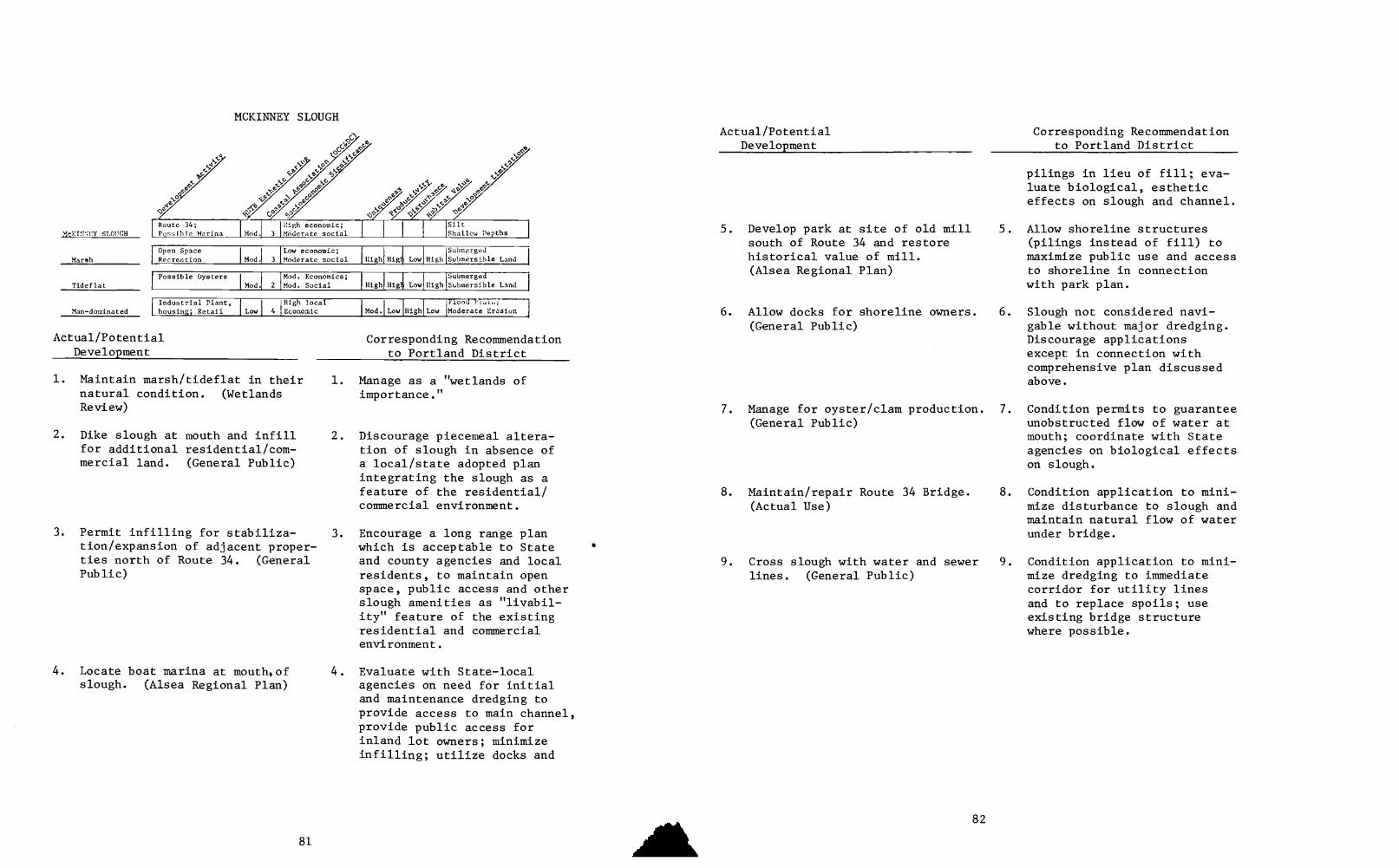
cKT!':',:EY SLOUGH
Marsh
Tideflat
Man-dominated
yo
Os
Po
ti
Route 34;Possible Marina
MCKINNEY SLOUGH
-10
G
High economic;Moderate social
Open SpaceRecreation IMod.1 3
Low economic;Moderate social Low
SubmergedHigh Submersible Land I
Possible OystersMod. 2
Mod. Economics;Mod. Social High High Low High
SubmergedSubmersible Land
Industrial Plant,housing; Retail
'High localLow 4 lEconomic Moddlow High Low
Actual/PotentialDevelopment
1. Maintain marsh/tideflat in theirnatural condition. (WetlandsReview)
2. Dike slough at mouth and infillfor additional residential/com-mercial land. (General Public)
Flood-7,7,1";
Moderate Erasion
Corresponding Recommendationto Portland District
3. Permit infilling for stabiliza-tion/expansion of adjacent proper-ties north of Route 34. (GeneralPublic)
4. Locate boat marina at mouth,ofslough. (Alsea Regional Plan)
81
1. Manage as a "wetlands ofimportance."
2. Discourage piecemeal altera-tion of slough in absence ofa local/state adopted planintegrating the slough as afeature of the residential/commercial environment.
3. Encourage a long range planwhich is acceptable to Stateand county agencies and localresidents, to maintain openspace, public access and otherslough amenities as "livabil-ity" feature of the existingresidential and commercialenvironment.
4. Evaluate with State-localagencies on need for initialand maintenance dredging toprovide access to main channel,provide public access forinland lot owners; minimizeinfilling; utilize docks and
AIL
Actual/PotentialDevelopment
5. Develop park at site of old millsouth of Route 34 and restorehistorical value of mill.(Alsea Regional Plan)
6. Allow docks for shoreline owners.(General Public)
Corresponding Recommendationto Portland District
pilings in lieu of fill; eva-luate biological, estheticeffects on slough and channel.
5. Allow shoreline structures(pilings instead of fill) tomaximize public use and accessto shoreline in connectionwith park plan.
6. Slough not considered navi-gable without major dredging.Discourage applicationsexcept in connection withcomprehensive plan discussedabove.
7. Manage for oyster/clam production. 7. Condition permits to guarantee(General Public) unobstructed flow of water at
mouth; coordinate with Stateagencies on biological effectson slough.
8. Maintain/repair Route 34 Bridge.(Actual Use)
8. Condition application to mini-mize disturbance to slough andmaintain natural flow of waterunder bridge.
9. Cross slough with water and sewer 9. Condition application to mini-lines. (General Public) mize dredging to immediate
corridor for utility linesand to replace spoils; useexisting bridge structurewhere possible.
82
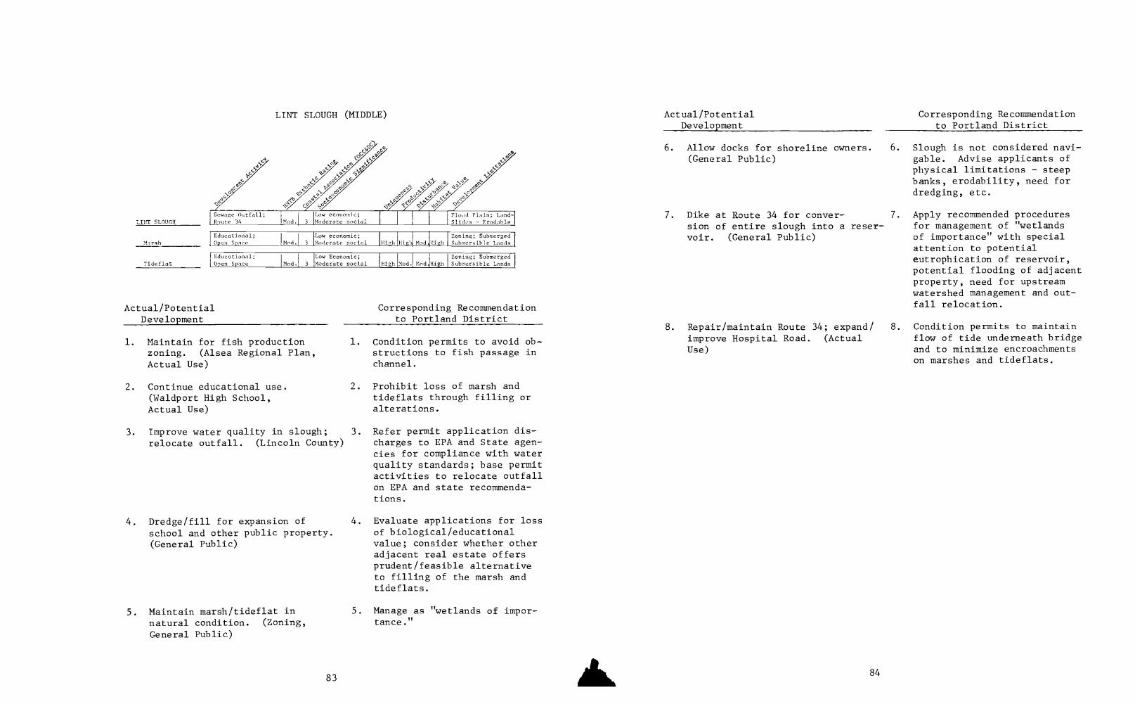
LINT SLOUGH (MIDDLE) Actual/Potential
tiff
s;°
ti'"
tia
6.
NP
LINT SLOUCH
if° ,z'>
c, Jo
C
7.[Sewage Outfall;Route 34 Mod. 3
Low economic;Moderate social
Flood Plain; Land-Slides - tradable
Educational;
Low economic; Zoning; SubmergedMar4h Open Space Mod. 3 Moderate social High iligl Mod. High Submersible Lands
Educational; Low Economic; I Zoning; SubmergedTideflat Omen Space 'Mod. 3 'Moderate social High Mod. tincl.lHigh I Submersible Lands
Actual/PotentialDevelopment
1. Maintain for fish productionzoning. (Alsea Regional Plan,Actual Use)
2. Continue educational use.(Waldport High School,Actual Use)
Corresponding Recommendationto Portland District
1. Condition permits to avoid ob-structions to fish passage inchannel.
2. Prohibit loss of marsh andtideflats through filling oralterations.
3. Improve water quality in slough; 3.
relocate outfall. (Lincoln County)
4. Dredge/fill for expansion ofschool and other public property.(General Public)
5. Maintain marsh/tideflat innatural condition. (Zoning,
General Public)
83
Refer permit application dis-charges to EPA and State agen-cies for compliance with waterquality standards; base permitactivities to relocate outfallon EPA and state recommenda-tions.
4. Evaluate applications for lossof biological/educationalvalue; consider whether otheradjacent real estate offersprudent/feasible alternativeto filling of the marsh andtideflats.
5. Manage as "wetlands of impor-tance."
Corresponding RecommendationDevelopment to Portland District
Allow docks for shoreline owners. 6. Slough is not considered navi-(General Public) gable. Advise applicants of
physical limitations steepbanks, erodability, need fordredging, etc.
Dike at Route 34 for conver- 7. Apply recommended proceduression of entire slough into a reser- for management of "wetlandsvoir. (General Public) of importance" with special
attention to potentialeutrophication of reservoir,potential flooding of adjacentproperty, need for upstreamwatershed management and out-fall relocation.
8. Repair/maintain Route 34; expand/ 8. Condition permits to maintainimprove Hospital Road. (Actual flow of tide underneath bridgeUse) and to minimize encroachments
on marshes and tideflats.
84
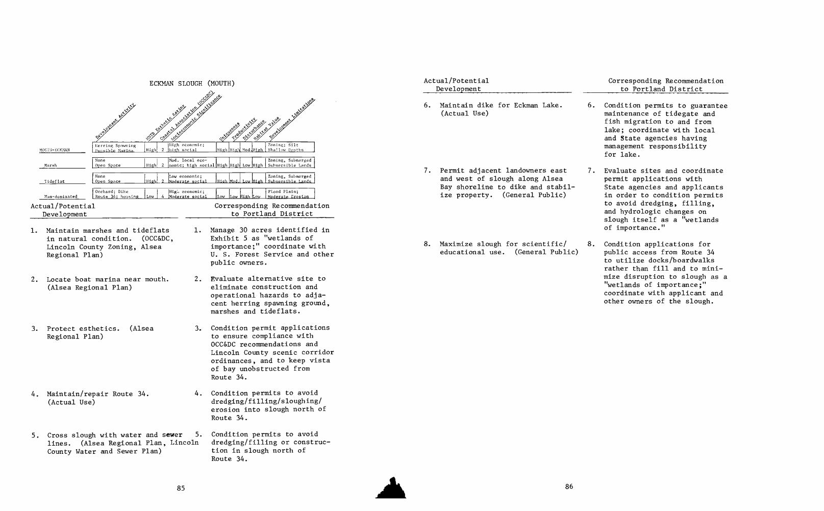
MOUTH-ECK,AN
Marsh
Tideflat
Herring Spawning1Highl'oasibLe Marina_
MC SLOUGH GH
.c
o
UTH)
(sN>, !)mac
;§
K>S' P° per~,C0
lacocoICPF/4t°
2
High economic;high social High Hight
Zoning; SiltShallow Depths
NoneOpen Space
Mod. local eco-Highl 2 Inomic; high social High High Low
Zoning, SubmergedHigh Submersible Lards
NoneOpen Space High 2
Low economic;Moderate social High Mod. _Low ill eh
Zoning, Submergedquhmersible Lands
Orchard; DikeMan-dominated Route 34; housing
Actual/PotentialDevelopment
LowHig:, economic;
4 Moderate socialFlood Plain;
Low Low }Sigh Low Moderate Erosion
1. Maintain marshes and tideflatsin natural condition. (OCC&DC,
Lincoln County Zoning, AlseaRegional Plan)
2. Locate boat marina near mouth.(Alsea Regional Plan)
3. Protect esthetics. (AlseaRegional Plan)
4. Maintain/repair Route 34.(Actual Use)
Corresponding Recommendationto Portland District
1. Manage 30 acres identified inExhibit 5 as "wetlands ofimportance;" coordinate withU. S. Forest Service and otherpublic owners.
2. Evaluate alternative site toeliminate construction andoperational hazards to adja-cent herring spawning ground,marshes and tideflats.
3. Condition permit applicationsto ensure compliance withOCC&DC recommendations andLincoln County scenic corridorordinances, and to keep vistaof bay unobstructed fromRoute 34.
4. Condition permits to avoiddredging/filling/sloughing/erosion into slough north ofRoute 34.
5. Cross slough with water and sewer 5. Condition permits to avoid
lines. (Alsea Regional Plan, Lincoln dredging/filling or construc-
County Water and Sewer Plan) tion in slough north ofRoute 34.
Actual/PotentialDevelopment
6. Maintain dike for Eckman Lake.(Actual Use)
7. Permit adjacent landowners eastand west of slough along AlseaBay shoreline to dike and stabil-ize property. (General Public)
Corresponding Recommendationto Portland District
6. Condition permits to guaranteemaintenance of tidegate andfish migration to and fromlake; coordinate with localand State agencies havingmanagement responsibilityfor lake.
7. Evaluate sites and coordinatepermit applications withState agencies and applicantsin order to condition permitsto avoid dredging, filling,and hydrologic changes onslough itself as a "wetlandsof importance."
8. Maximize slough for scientific/ 8. Condition applications foreducational use. (General Public) public access from Route 34
to utilize docks/boardwalksrather than fill and to mini-mize disruption to slough as a"wetlands of importancercoordinate with applicant andother owners of the slough.

UNDEVELOPEDFLOODPLAIN
Riparian
UNDEVELOPED FLOODPLAINSouth Bank-River Mile 5.5-8
Route 34; FarmMarine Residences
1
6-8 MarineResidences
High economic IFloodplain; SomeISpors Erodahle
High economic Steep Slopes;Narrow Eloodol,in
Diked/Agricultural Farm; Open SpacePasture Utility Lines Mod.
High economic3 Mod. Mod, Mod. Mod,
Floodplain
Actual/PotentialDevelopment
1. Develop for marine recreational/residential uses; provide waterand sewer services. (Zoning,Alsea Regional Plan, LincolnCounty Comprehensive Water andSewer Plan)
2. Maintain in existing agricul-tural/open space use. (ActualUse)
3. Permit docks, floats and bankstabilization for existing resi-dents. (General Public)
Corresponding Recommendationto Portland District
I Evaluate applications for in-filling of floodplain andtidal meanders with LincolnCounty, State agencies andapplicants; prepare environ-mental assessment specificallyon cumulative hydrologic ef-fects downstream and floodabsorption loss; requirecounty certification thatanticipated development meetsLincoln County floodplain andesthetic corridor ordinances;condition permits to limitpermanent facilities to landsabove the Mean High High Tide.
2. Limit favorable considerationto permits for maintenance/repair of existing dikes andtidegates for present owners.
3. Condition permits and site,evaluate with applicant tominimize extent of bank fill-ing, utilize only where novegetative stabilization ex-ists, suitable riprap andstabilization and minimizedock extension seaward intonarrow navigable channel;
Actual/PotentialDevelopment
4. Construct moorage in generalvicinity. (Alsea Regional Plan)
5. Use as corridor for water andsewer lines. (Lincoln CountyComprehensive Water and Sewer Plan)
6. Repair/maintain Route 34.(Actual Use)
7. Install new power and utilitylines and maintain existing lines.(General Public)
Corresponding Recommendationto Portland District
limit favorable considerationto existing facilities, resi-dences and property alreadydeveloped.
4. Offers an alternative to pro-liferation of docks alongnarrow reach of river. Condi-tion application to ensureease of public navigation innarrow reaches of river,particularly where docks existon opposite bank; conditionapplication to maximize publicaccess and enhance esthetics;group storage, parking andpermanent facilities on higherground, to avoid need for fill-ing and to meet county flood-plain ordinances; coordinatesite suitability with LincolnCounty and State agencies.
5. Condition applications tominimize dredging and fillingof floodplain and tidalmeanders.
6. Condition permits to minimizefilling in floodplain and tidalmeanders and erosion of mater-ials at steep bank (opportuni-ties exist for public vistasat higher locations on ridgeopposite Barclay Meadows).
7 Evaluate permits for alter-native crossings in view ofhigh esthetic values on northbank; condition permits toconform to Lincoln Countyscenic roadway and corridorordinances.

DEVELOPEDFIOOD.TATN
Man-dominated
Actual/PotentialDevelopment
DEVELOPED/DEVELOPING FLOODPLAINSSouth Bank River Mile 2-3.5
0
c?
by
Ja
oa
Old Piling; Manyharks 1nmes
cr
4P.5P
Mod 3
High economic andSocial
Silted Channel
Route 34I Lo 4
High economic andSocial Mod. Low High
Narrow R.O.W.Low Highly Erodable
Corresponding Recommendationto Portland District
1. Continue residential/commercial 1. None.development; provide water andsewer services. (Zoning, AlseaRegional Plan, Lincoln CountyComprehensive Water and SewerPlan)
2. Maintain/repair existing shore-line facilities, docks and bulk-head; allow new and replacementbankline facilities. (GeneralPublic)
3. Dredge silt deposition atexisting docks to provide navi-gation to main channel.(General Public)
89
2. Condition permits and siteevaluations with applicant tominimize infilling for bankstabilization and maintaindock lengths into Alsea Bayat necessary minimums (mayhave to be extended because ofsilt deposition along shore-line; consider in conjunctionwith limited dredging dis-cussed under MAIN CHANNEL);expedite permits for repairmaintenance of existing faci-lities.
3. Explore with local and Stateagencies whether silt consti-tutes major obstruction tonavigation; evaluate alterna-tive solutions to dredgingshould hydrologic and biolo-gical effects on estuaryappear significant.
Actual/PotentialDevelopment
Corresponding Recommendationto Portland District
4. Locate public marina facilities. 4. Condition applications tomaximize access for inland lotowners and minimize environ-mental impacts.
DEVELOPED/DEVELOPING FLOODPLAINSSouth Bank River Mile 3.5-5.5
(Alsea Regional Plan)
DEVELOPEDPOODPLAIN
Man-dominated
tic
tP
cti
0
V N.
mac
,<0
RecreationTouristPletail_ Mod. 3
High economicand social
Financing; SiltSnags
Marinas, Docks; ' High economic
Fill, homes IMod.1 3 and social Mod. Low Mgt. LowModerate Erosion
Filling, DikingMarsh
Actual/PotentialDevelopment
Mod 2
High economicand social Mod. Low Higl Low
SubmergedSubmersible Lands
1. Continue marine residential/recreational development; pro-vide water and sewer service.(Zoning, Alsea Regional Plan,Ldncoln County ComprehensiveWater and Sewer Plan)
2. Maintain/repair existing shore-line facilities, docks andbulkhead; allow new and replace-ment bankline facilities.(General Public)
90
Corresponding Recommendationto Portland District
1. None.
2. Condition permits and siteevaluations with applicantto minimize infilling forbank stabilization and tomaintain dock lengths intoAlsea Bay at necessary mini-mums (may have to be extendedbecause of silt depositionalong shoreline, consider inconjunction with limiteddredging discussed underMAIN CHANNEL); expedite permitsfor repair/maintenance ofexisting facilities.

Actual/Potential Corresponding RecommendationDevelopment to Portland District
3. Dredge silt deposition at exist- 3. Explore with local and Stateing docks to provide navigation agencies whether silt consti-to main channel. (General Public) tutes major obstruction to
navigation; evaluate alterna-tive solutions to dredgingshould hydrologic and biolo-gical effects on estuaryappear significant.
4. Locate public marina facilities.(Alsea Regional Plan)
91
4. Condition applications tomaximize access for inlandlot owners; expedite consi-deration of permit applica-tions particularly for repairs;determine with riparian ownersand local and State agencies aline (roughly at the Mean HighWater Mark) delineating theextent of upland fill in orderto halt current trends towardlandfilling of remaining highmarshes and tideflats (parti-cular attention should be paidto downstream hydrologic andbiological effects on themarshes, tidelands and herringground at Lint Slough; and topotential loss of flood ab-sorption capacity of existingmarshes); explore with marineoperators the possibility ofproviding public access viaboardwalks and docks which areparallel to the river in orderto link marina facilities(would enhance public enjoy-ment and economic opportunities).
Man-dominated
Agricultural/Pasture
Riparian
DEVELOPED/DEVELOPING FLOODPLAINS
s.ts
Subdivision
BARCLAY MEADOWS
wga
Jai
Mod. 3
High economicand social
Water, Sewer,
Zoning. Access
Many Docks; homestrailers Mod.' 3
High economicand social Mod. Low High Low
Flood Hazards
Open SpaceGrazing !High 4
Moderate economic;high social Mod. ModiMod. Mod.
Floodplain
Bank Clearance;Stabilization
High economicMod. 4 and social Mod.! Low High Low
Erodable
Actual/PotentialDevelopment
Corresponding Recommendationto Portland District
1. Eliminate inconsistencies among 1. None.zoning, planning recommendationsand actual use. (Alsea RegionalPlan)
2. Minimize proliferation of privatedocks along river. (AlseaRegional Plan)
2. Condition permit applicationsfor new docks to require cer-tification by Lincoln Countythat development activity isconsistent with county ordin-ances and floodplain regula-tions; evaluate possible pro-vision and use of centralizeddock facilities with LincolnCounty, State agencies andthe subdivider as an alterna-tive to extensive new facili-ties.
3. Continue development "infilling" 3.
for lots already sold and subdivided;limit lateral extension of subdivisionalong river. (General Public)
Same as above.
4. Allow maintenance and repair of 4. Condition permits to avoidexisting docks/facilities and bank extension of dock lengthsstabilization for properties with beyond furthermost line of
92

Actual/PotentialDevelopment
such facilities; allow new docksand bank stabilization for lotsalready sold and/or subdivided.(General Public, Actual Use)
Corresponding Recommendationto Portland District
existing docks; to protectpublic navigation opportuni-ties on narrow reaches ofriver; to ensure use of suit-able stabilizing structuresand materials; to avoid removalof riparian vegetation wherepossible.
5. Maintain/protect/restore esthetic 5. Implement above recommenda-qualities of river zone. (Alsea tions; evaluate alternativeRegional Plan) sites in connection with
applications for power andother utility lines crossingriver.
ALDER SPRINGSACRES
Man-dominated
DEVELOPED/DEVELOPING FLOODPLAINSALDER SPRINGS ACRES
4-' .ep
,J, :.'- .c,
,N
CP e..,P
2,"' c>9
c'/>:::';'''. ;./(sci/''c":"cyct,c,/7.0":""44' c)'? °'''
,§' e ,..0 x:-, 40
e, ,;,4 ,6s.. A s
e00 e N.
N.
yam
ee
ae
SubdivisionMod.
',Low economic;
3 Migh social
Water, Sewer,Zoning, Access
Docks; Approx.15 Trailers Mod.' 3
Low economic;High social Mod.Low High
!Flood HazardsLow
Bank Clearance
Riparian
Actual/PotentialDevelopment
Mod.
ow economic;4 igh social Mod.Low High Low
Highly Erodable
Corresponding Recommendationto Portland District
1. Eliminate inconsistencies among 1. None.
zoning, planning recommendationsand actual use. (Alsea RegionalPlan)
2. Minimize proliferation of private 2. Condition permit applicationsdocks along river (Alsea Regional for new docks to requirePlan) certification by Lincoln County
93
Actual/PotentialDevelopment
Corresponding Recommendationto Portland District
that development activity isconsistent with county ordin-ances and floodplain regula-tions; evaluate possible pro-vision and use of centralizeddock facilities with LincolnCounty, State agencies and thesubdivider as an alternativeto extensive new facilities.
3. Continue development "infilling" 3. Same as above.for lots already sold and sub-divided; limit lateral extensionof subdivision along river.(General Public)
4. Allow maintenance and repair ofexisting docks/facilities andbank stabilization for propertieswith such facilities; allow newdocks and bank stabilization forlots already sold and/or subdivided.(General Public, Actual Use)
5. Maintain/protect/restoreesthetic qualities of riverzone. (Al ea Regional Plan)
94
4. Condition permits to avoidextension of dock lengthsbeyond furthermost line ofexisting docks; to protectpublic navigation opportuni-ties on narrow reaches ofriver; to ensure use of suit-able stabilizing structuresand materials.
5. Implement above recommenda-tions, evaluate alternativesites in connection withapplications for power andother utility lines crossingriver.
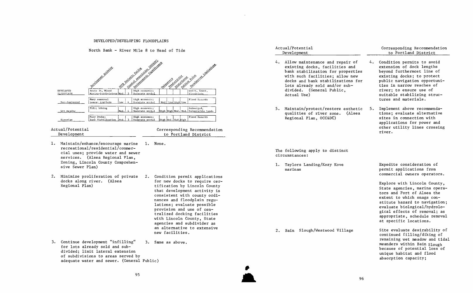
DEVELOPEDFLOODPLAIN
Man-dominated
Wet meadow
Riparian
DEVELOPED/DEVELOPING FLOODPLAINS
North Bank - River Mile 8 to Head of Tide
ti
>;yyz
,cc
OcRoute 34, Mixed
,Marina- Subdivisions
High economic;Moderate social
Water, Sewer,Floodnlain
Many seasonalhomes; trailers Low I 4
High economic;Moderate social Mod. Low High
!Flood HazardsLow
Fill; bikingMod. 4
High economic;'Moderate social High High Mod. Mod.
Submerged,Submersible Lands
Many Docks;Bank Stabilization
High economic;Mod. 3 Moderate social High [fod. Mod. High
Flood Hazards
Actual/PotentialDevelopment
Corresponding Recommendationto Portland District
1. Maintain/enhance/encourage marine 1. None.recreational/residential/commer-cial uses; provide water and sewerservices. (Alsea Regional Plan,Zoning, Lincoln County Comprehen-sive Sewer Plan)
2. Minimize proliferation of privatedocks along river. (AlseaRegional Plan)
2. Condition permit applicationsfor new docks to require cer-tification by Lincoln Countythat development activity isconsistent with county ordi-nances and floodplain regu-lations; evaluate possibleprovision and use of cen-tralized docking facilitieswith Lincoln County, Stateagencies and subdivider asan alternative to extensivenew facilities.
3. Continue development "infilling" 3. Same as above.for lots already sold and sub-divided; limit lateral extensionof subdivisions to areas served byadequate water and sewer. (General Public)
95
Actual/PotentialDevelopment
4. Allow maintenance and repair ofexisting docks, facilities andbank stabilization for propertieswith such facilities; allow newdocks and bank stabilizations forlots already sold and/or sub-divided. (General Public,Actual Use)
Corresponding Recommendationto Portland District
4. Condition permits to avoidextension of dock lengthsbeyond furthermost line ofexisting docks; to protectpublic navigation opportuni-ties in narrow reaches ofriver; to ensure use ofsuitable stabilizing struc-tures and materials.
5. Maintain/protect/restore esthetic 5.
qualities of river zone. (AlseaRegional Plan, OCC&DC)
The following apply to distinctcircumstances:
1. Taylors Landing/Kozy Kovemarinas
2. Bain Slough/Westwood Village
96
Implement above recommenda-tions; evaluate alternativesites in connection withapplications for power andother utility lines crossingriver.
Expedite consideration ofpermit applications fromcommercial owners operators.
Explore with Lincoln County,State agencies, marina opera-tors and Port of Alsea theextent to which snags con-stitute hazard to navigation;evaluate biological/hydrolo-gical effects of removal; asappropriate, schedule removalat specific locations.
Site evaluate desirability ofcontinued filling/diking ofremaining wet meadow and tidalmeanders within Bain Sloughbecause of potential loss ofunique habitat and floodabsorption capacity;
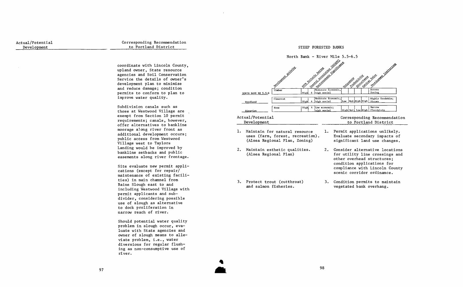
Corresponding Recommendationto Portland District
coordinate with Lincoln County,upland owner, State resourceagencies and Soil ConservationService the details of owner'sdevelopment plan to minimizeand reduce damage; conditionpermits to conform to plan toimprove water quality.
Subdivision canals such asthose at Westwood Village areexempt from Section 10 permitrequirements; canals, however,offer alternatives to banklinemoorage along river front asadditional development occurs;public access from WestwoodVillage west to TaylorsLanding would be improved bybankline setbacks and publiceasements along river frontage.
Site evaluate new permit appli-cations (except for repair/maintenance of existing facili-ties) in main channel fromBaine Slough east to andincluding Westwood Village withpermit applicants and sub-divider, considering possibleuse of slough as alternativeto dock proliferation innarrow reach of river.
Should potential water qualityproblem in slough occur, eva-luate with State agencies andowner of slough means to alle-viate problem, i.e., waterdiversions for regular flush-ing as non-consumptive use ofriver.
97
NORTH BANK RM 5.5-6
Woodland
_Riparian
STEEP FORESTED BANKS
North Bank - River Mile 5.5-6.5
GGbOG°0
N///:"' Goa -0
,,foK.P
Cz>.
44e4;:://'yae ,()
Timber Moderate Economic,High 4 high social
AccessZoning
Clearcut Moderate EconomicdlHig 4 high social Low Mod.High High
Highly Erodable;Slopes
None
Actual/PotentialDevelopment
High 4 Low economic;high social High Mod. Lo High
NarrowFloodplain
Corresponding Recommendationto Portland District
1. Maintain for natural resource 1.
uses (farm, forest, recreation).(Alsea Regional Plan, Zoning)
2. Maintain esthetic qualities.(Alsea Regional Plan)
3. Protect trout (cutthroat)and salmon fisheries.
98
Permit applications unlikely.Evaluate secondary impacts ofsignificant land use changes.
2. Consider alternative locationsfor utility line crossings andother overhead structures;condition applications forcompliance with Lincoln Countyscenic corridor ordinance.
3. Condition permits to maintainvegetated bank overhang.

SOUTH BANKRM 8 -HEAD OF TIDE
STEEP FORESTED BANKS
South Bank River Mile 8 to Head of Tide
PGt
eo
oc
c,," Soof
.a*QLj
V'Phi
NaturalResource Zone High_ 4
Moderate econ.;high social
Zoning; AccessWater Sewers
'Timber
Woodland Production
Riparian
High 4
Moderate econ.;high social Low High Lo High
Steep Slopes;Erodahie
oneIHighl 4
Low Economic;high social III eh Mod. Lo High
Floodplain
AgricultureField/Farm
Actual/PotentialDevelopment
Mod. 4
Moderate econ. Zoning; Access;
Moderate social Mod. Mod. Mod. High Water: Sew.21.
Corresponding Recommendationto Portland District
1. Maintain for natural resource uses 1.
(farm, forest, recreation).(Alsea Regional Plan, Zoning)
2. Maintain esthetic qualities.(Alsea Regional Plan, U. S.Forest Service)
3. Protect fisheries.(General Public)
4. Locate bridge crossing upstreamof Taylors Landing as replace-ment to Canal Creek Road.
5. Install/maintain/repair mooragefor riparian owner at oxbowopposite Little Switzerland.
99
Except at Alder Springs Acres,permit applications may sig-nal major land use changeswhich should be evaluated.
2. Consider alternative locationsfor utility line crossingsand other overhead structures;condition permit applicationsfor compliance with LincolnCounty scenic corridor ordi-nance.
3. Condition permits to maintainvegetated bank overhang.
4. Explore need for environmentalassessment with U. S. ForestService in view of potentialfor significant increase indevelopment along Canal Creek.
5. Condition permits to apply toexisting structures; limitfavorable consideration towork required to serve navi-gation access needs of agri-cultural residents.
Actual/PotentialDevelopment
Corresponding Recommendationto Portland District
6. Maintain/repair foot bridges from 6. Condition permits to retainnorth to south bank. historical interest consistent
with needs of public safety.
PORTDOCKS/LINT SLOUCH
Marina
PORT DOCKS/LINT SLOUGH
Recreation; FishingCrahbinz; Retail Mod. 2
High Economic andSocial
Lack of_Develop-nent Plan
I Fill, Docks,Breakwater Mod.
(High Economic and2 'Social Mod.11ow High Low
Financing;Limited Services
Public Parking, I
Man-dominated Bait-Tackle Shops Low I 3
Actual/PotentialDevelopment
High Economic and Program to attractSocial Mod. Low nigh Low Tourism
Corresponding Recommendationto Portland District
1. Maximize marine-oriented recrea-tional/commercial/tourist uses.(Alsea Regional Plan, Zoning)
100
1. Expedite consideration ofpermit applications from Portof Alsea and private ownersand operators. Conditionapplications to:
a. limit further land-filling of submerged/submersible lands
b. insure maintenance ofstabilized banks(riprapped/vegetated)
c. avoid interferencewith public navigationin main channel ofAlsea Bay and LintSlough; limit seawardextension of docks
Actual/PotentialDevelopment
Corresponding Recommendationto Portland District
and other structuresto the length neces-sary in order to facil-itate parallel ratherthan perpendicular ex-tension of facilitiesfrom bankline.
d. Ensure adequate accessfor general public onpiers, groins, jettiesand other facilitiesconstructed over orwithin the historicline of the MeanHigher High Tide.
2. Dredge channel/slough for mainte- 2. Condition permits to ensurenance and improvement of recrea- disposal of spoils in approvedtional navigation. (General Public) disposal site; site evaluate
removal of tidal island oppo-site Port of Alsea docks forhydrologic change in regimeof river and potential lossof shoreline wind and waterbuffer.
3. Improve esthetics/integratedevelopment plans for slough andPort of Alsea facilities to in-crease attractiveness for residents/tourists and to restore and capital-ize on historic treatment of "OldWaldport, i.e., install footbridgeover mouth of Lint Slough to pro-vide pedestrian access betweenport docks and McKinley's Marina;install boardwalks, tree planting,picnic facilities, etc. (AlseaRegional Plan, General Public)
101
3. Except for repair, maintenanceand improvement to existingfacilities, encourage prepara-tion of a site developmentplan to integrate public usesof Lint Slough and historicwaterfront site at Mill Streetand provide as a guide forconsideration of future permitapplications for major expan-sion of public/private facili-ties; ensure public participa-tion and approval by City ofWaldport, Lincoln County,State agencies, Port of Alsea,private owner/operators.
DISPOSAL SITES
McKinley's Marina
South BankRM 3.5-5.5(above MHW)
s,
eyo
DISPOSAL SITES
Potential ForDredged Disposal
by
ocrti
"N,
c,.7-
High Economic OfficialApproval/Plan
Diked 30,000 I
C.X. Capacity Low I 3
High EconomicMod. Low High
OfficialLow Approval /Plan
Undiked; PossibleBuilding Sites Low 3
High EconomicMod. _Low High Low
Intrusion onMarsh Remnant
Actual/PotentialDevelopment
Corresponding Recommendationto Portland District
1. Gain official local/State approval 1
for use of diked area west of LintSlough as a dredge disposal site.(Actual Use)
2. Consider use of lands adjacent toRoute 34 between river mile 3.5and 5.5 as dredge disposal site.(General Public)
102
. Condition permits for use ofsite to ensure public accessadjacent to Lint Slough;restrict to marine-related use;encourage integration of siteplan with development plan forold waterfront and Lint Slough.
2. Determine with riparian ownersand local and state agencieslocation of a line (roughlyat the Mean High Water Mark)to delineate the extent ofacceptable upland fill as dis-cussed in the summation ofDeveloped/Developing flood-plains; condition permits tominimize extent of loss ofremaining marshes and tidalmeanders.

HISTORIC SITES/FACILITIES
Actual/PotentialDevelopment
1. Review historical significanceof following water-relatedstructures:
a. abandoned railroad pilingsadjacent to Route 34 be-tween McKinley's Marinaand the "Oyster House"
b. the "Oyster House"
c. the abandoned lumber millon McKinneys Slough
d. J. C. Barnes Store - abandonedpilings at Sheppard Point.
(Wetlands Review)
103
Corresponding Recommendationto Portland District
1. Evaluate applications forremoval/restoration/replace-ment with applicant regardingpotential historical valueconsistent with needs ofpublic safety; evaluate appli-cations for large-scale pileremoval with State agenciesfor potential sulphide releasefrom benthic muds.
Actual/PotentialDevelopment
TRANSPORTATION CORRIDORS
Corresponding Recommendationto Portland District
1. Maintain/improve U. S. Highway 101. 1
(Actual Use)
2. Maintain/improve Route 701 or(702 extension). (Actual Use)
104
Maintain sea wall at southernentrance to Waldport; considerin future the expansion ofroad width to improve publicsafety and vehicular parking;review permit applications tominimize disruption of rock-oyster beds, eelgrass, andpreemption of recreationalbeach.
2. Condition permit applicationsto ensure against bank slump-ing from steeper slopes ontotidelands and marshes of northside of bay, and to limitfilling/removal of log debris(marsh and bankline stabili-zation features) at shoreline;do not dredge road materialsidentified from marshes andtideflats as "wetlands ofimportance".
Permit applications involvingupgrading of Route 702 exten-sion east of Bayview may
Actual/Potential Corresponding RecommendationDevelopment to Portland District
signal significant changefrom farm/forest/recreationuses to more intense develop-ments on north side of bay;evaluate with Lincoln Countyand Oregon Highway Department.
3. Improve existing Canal Creek Road.. 3. Evaluate improvement with(U. S. Forest Service) U. S. Forest Service to
ensure against log debris andbank slumping from steepslopes into river. (Also,
see discussion on alternativebridge crossing in summationon Developed Floodplain,River Mile 8 to Head of Tide).
4. Maintain/repair/upgrade Route 34. 4. Condition permit applications(Actual Use) to:
a. maintain tidal flow atLint and McKinneySloughs
b. avoid dredging or fill-ing of marshes andwetlands at EckmanSlough identified as"wetlands of impor-tance"
c. limit filling of un-developed floodplainfrom river mile 5.5to 8. (see summation)
d. minimize river fillfor bank stabilizationupstream to head oftide.
105


