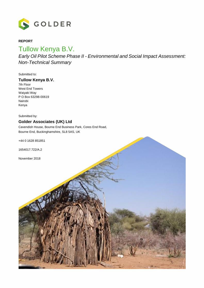
REPORT Tullow Kenya B.V. Early Oil Pilot Scheme Phase II - Environmental and Social Impact Assessment: Non-Technical Summary Submitted to: Tullow Kenya B.V. 7th Floor West End Towers Waiyaki Way P O Box 63298-00619 Nairobi Kenya Submitted by: Golder Associates (UK) Ltd Cavendish House, Bourne End Business Park, Cores End Road, Bourne End, Buckinghamshire, SL8 5AS, UK +44 0 1628 851851 1654017.722/A.2 November 2018
Transcript
REPORT
Tullow Kenya B.V. Early Oil Pilot Scheme Phase II - Environmental and Social Impact Assessment:
Non-Technical Summary
Submitted to:
Tullow Kenya B.V. 7th Floor
West End Towers
Waiyaki Way
P O Box 63298-00619
Nairobi
Kenya
Submitted by:
Golder Associates (UK) Ltd
Cavendish House, Bourne End Business Park, Cores End Road,
2.3 Soils, Geology and Seismicity ........................................................................................................... 5
2.4 Air Quality .......................................................................................................................................... 5
2.5 Noise and Vibration ........................................................................................................................... 6
2.6 Water Quantity .................................................................................................................................. 6
2.7 Water Quality..................................................................................................................................... 6
2.8 Landscape and Visual ....................................................................................................................... 6
2.9 Biodiversity, Ecology and Protected Areas ....................................................................................... 6
2.11 Social ................................................................................................................................................. 7
2.12 Cultural Heritage ............................................................................................................................... 8
3.1 Groundworks and Maintenance ...................................................................................................... 11
3.2 Infrastructure and Operation ........................................................................................................... 11
3.3 Production ....................................................................................................................................... 13
4.3 Soils, Terrain, Geology and Seismicity ........................................................................................... 14
4.4 Air Quality ........................................................................................................................................ 14
4.5 Noise and Vibration ......................................................................................................................... 14
4.6 Water Quantity ................................................................................................................................ 15
4.7 Water Quality................................................................................................................................... 15
4.8 Landscape and Visual ..................................................................................................................... 15
4.9 Biodiversity, Ecology and Protected Areas ..................................................................................... 15
4.11 Social ............................................................................................................................................... 16
4.12 Cultural Heritage ............................................................................................................................. 17
4.13 Environmental Risks and Accidents ................................................................................................ 17
5.0 ASSESSMENT OF RESIDUAL IMPACTS ............................................................................................... 17
7.0 ENVIRONMENTAL AND SOCIAL MANAGEMENT PLAN ..................................................................... 18
FIGURES
Figure 1: Upstream and Midstream Locations ..................................................................................................... 9
Figure 2: Upstream Location Plan ...................................................................................................................... 10
Figure 3: Summary Schematic of the EOPS Project including aerial image of Amosing-1 and articulated truck loaded with tanktainer (From Tullow EOPS ESIA Consultation Presentation)................................................... 12
November 2018 1654017.722/A.2
3
1.0 INTRODUCTION
Tullow Kenya B.V. (TKBV) is evaluating the development of a series of oil discoveries made in the South
Lokichar Basin, northwest Kenya. This document is the Non-Technical Summary (NTS) of the Environmental
and Social Impact Assessment (ESIA) for Phase 2 of the Early Oil Pilot Scheme (EOPS), referred to here as
‘the Project’. This document describes the main features of the Project, presents the current environmental and
social conditions in the Project area and discusses the potential environmental and social impacts associated
with the Project, as well as mitigation and management measures that are proposed to avoid or minimise
adverse impacts and enhancement measures proposed to maximise beneficial impacts.
1.1 Background
The proposed EOPS represents an initial phase in the full commercialisation of the hydrocarbon resources that
have already been discovered in the South Lokichar Basin. These resources will be fully developed during the
Full Field Development (FFD) phase.
The EOPS Project is divided into two stages. Phase 1 covers the existing trucking of stored crude oil produced
during the Extended Well Testing (EWT) carried out during the exploration and appraisal phase, which is
covered under the existing EWT EIA licenses. Phase 2 will cover the installation of EOPS facilities, the
production of limited quantities of crude oil from existing wells at Amosing and Ngamia fields and the operation
of the EOPS Early Production Facility (the oil production is also known as the Upstream component of the
Project, hereafter, Upstream). The oil will then be transported, using existing road infrastructure, to Mombasa
for storage (the transport of the crude oil occurs in what is known as the Midstream component of the Project).
No additional land will be required for realisation of the EOPS Project.
The EOPS ESIA addresses Phase 2 only. Within this document, where the term EOPS is used this refers
exclusively to Phase 2 (unless explicitly stated).
The Project will be implemented by the Kenya Joint Venture (KJV): TKBV., Africa Oil Corporation and Total Oil,
with support from Kenya Highways Authority (KeNHA), Kenya Petroleum Refineries Limited (KPRL) and the
Government of Kenya (GoK).
1.2 Policy and Legislation
The ESIA has been prepared to meet Kenyan regulatory requirements in order to obtain necessary national
approvals from the National Environment Management Authority (NEMA). For the topics assessed, the ESIA
has been developed to be in-line with international standards (i.e. IFC Performance Standards on Environmental
and Social Sustainability (2012) and IFC’s General Environmental, Health and Safety (EHS) Guidelines (2007a,
2007b)). The ESIA also conforms to Tullow’s corporate EHS standards and policies.
NEMA is the administrative body that is responsible for the coordination of environmental management activities
in Kenya. NEMA is also the principal government authority for implementing all environmental policies and is
responsible for reviewing and approving ESIAs.
1.3 Stakeholder Engagement
Stakeholder engagement has been undertaken to ensure that legal requirements are met, sources of
information and expertise are identified, stakeholder concerns and expectations are registered and addressed
and affected communities have the opportunity to discuss Project risks, impacts and proposed mitigation and
monitoring measures.
The EOPS ESIA Scoping Consultations were initiated in May 2016 and included a series of meetings to disclose
EOPS and to explain the ESIA process to key stakeholders. Consultations were held with the government,
international organisations, the regional media and international, national and regional NGOs. During the
November 2018 1654017.722/A.2
4
Scoping Consultations, a total of 212 issues, questions and concerns were documented. The following
represents the most frequently raised issues (% of total issues in parenthesis):
Engagement – 21%;
Environment (including water, traffic, air quality and climate, biology, restoration/reinstatement, and
pollution/waste) – 16%;
General Project Updates/Enquiries – 16%;
Community Aspects – 11%;
General ESIA Enquiries – 11%; and
Land Access and Acquisition – 5%.
The EOPS ESIA Consultations were started in June 2018. Interruptions to operations at the Kapese Camp then
forced the majority of the meetings to be postponed until late September 2018. In each meeting, the consultation
team sought to:
Provide information on the EOPS Project and review the EOPS ESIA process to key stakeholders;
Explain how the ESIA approach addressed both national regulations and international lender requirements;
Document issues, questions and concerns; and
Solicit feedback from key national and regional stakeholders for future consultation.
During the meetings, a total of 327 issues, questions and concerns were documented. The following represents
the most frequently raised issues (% of total issues in parenthesis):
Community Aspects (health, safety and security, benefits, cultural heritage and social maladies) - 21%;
Environment (including water, air quality, biology, pollution, traffic, visual and soil) – 20%;
Engagement – 18%;
Project Updates/Inquiries – 14%;
ESIA General Inquiries – 7%;
National Content – 6%;
Land Access & Acquisition – 6%; and
Security – 4%.
1.4 Impact Assessment Methodology
The ESIA process provides an opportunity to ensure that commitments can be made and designs can be
developed to minimise potential negative environmental and social impacts and maximise positive impacts. The
following describes the key phases of an ESIA project.
Scoping stage: The aim of scoping is to determine which impacts should become the main focus of the
ESIA. Scoping also identifies data availability, data gaps and suitable data gathering methods. The primary
output is the Terms of Reference for the ESIA, which is approved by NEMA and defines the contents and
approach to the ESIA, plus a supporting Project (Scoping) Report.
Baseline: A baseline report describes baseline data collection, which is undertaken to characterise the
existing environmental and social conditions within a defined study area, and to identify trends in such
conditions.
November 2018 1654017.722/A.2
5
Impact Assessment: The impact assessment process comprises the following main stages:
▪ Identification of receptors (e.g. receiving environment, ecosystems or communities) that could be
affected by the Project and study areas or areas of influence that the Project may have;
▪ Analysis of effects on receptors using modelling or other analyses to determine the magnitude of the
effect of the Project and different aspects of the environment;
▪ Impact determination and classification using a standard methodology;
▪ Development of mitigation measures and management processes; and
▪ Where necessary, analysis of residual effects, which incorporate proposed mitigation or management.
Environment and Social Management Plans: A series of documents which define the commitments to
mitigation and management by the Project proponent to minimise negative effects and maximise benefits
of the Project.
2.0 SUMMARY OF EXISTING ENVIRONMENTAL AND SOCIAL CONDITIONS
2.1 Introduction
The ESIA baseline describes in detail the existing environmental and social conditions in the Project area and
likely area of influence, so that impacts can be predicted with reference to the existing situation and so that the
pre-project situation has been recorded for management and monitoring purposes throughout the Project’s life.
2.2 Climate
Meteorological stations established at Kapese Camp and the Ngamia oil field are located approximately 80 to
100 km south of Lodwar, which is the primary reference station, and provides historic context (with a dataset of
34 years), as well as an understanding of meteorological trends.
The Upstream area has a warm desert climate with high average temperatures (>20°C) and little change in
temperature throughout the year. Humidity is relatively low in the dry season (<30%) and much higher in the
wet season (>50%). There are two rainy seasons, one between April and June and the other between October
and December. Wind speeds are generally low with little variation throughout the year. Winds are
predominantly easterly in direction. The measurements from the on-site meteorological stations, as well as the
Lodwar dataset, are reflective of the meteorological conditions within the Upstream area.
2.3 Soils, Geology and Seismicity
Soils in the Upstream area are generally nutrient-poor and prone to rapid erosion by wind and water. Soils
contain very few rocks or stones and are generally sandy with very little organic content.
2.4 Air Quality
Baseline air quality data (dust, emissions and particles in the air or particulates) was undertaken at Amosing,
Ngamia, Kapese Camp and Lokichar. For the majority of emissions, the baseline values are lower than Air
Quality Standards (AQS). The baseline values for particulates are higher than the AQS, indicating that the
levels of particulates are high in the Upstream area, possibly due to anthropogenic activities.
The Traffic Impact Analysis (TIA) did not indicate that baseline air quality data would need to be collected along
the EOPS road route (the Midstream component), due to the relatively low number of additional vehicle
movements associated with the Project.
November 2018 1654017.722/A.2
6
2.5 Noise and Vibration
Baseline data gathering was completed during three separate field surveys in four monitoring locations
(Lokichar, Amosing, Ngamia and Kapese Camp). Noise data was gathered to calculate an average daytime
and night time noise level for each of the four locations.
Noise levels are generally low and dominated by natural noise sources, such as watercourses and wind blowing
through vegetation. Higher noise levels were recorded in Lokichar, where noise from human activities, including
road traffic, human interaction and light engineering/construction activities, contributed to the baseline noise
levels.
Vibration sources in the environment are limited to road traffic, which only affects the area immediately next to
the source. Baseline vibration levels were not measured but are assumed to be similar to the natural
environment.
Taking the results of the TIA into consideration, it was considered that baseline noise surveys would not be
required along the EOPS road route.
2.6 Water Quantity
Groundwater is typically encountered at 5 m to 20 m below ground level and groundwater flows towards the
northeast, which corresponds with drainage towards the Kalabata (the main water course in the Project area).
Surface water does not flow in luggas (local term for ephemeral water courses) all year round; it only flows
periodically, following intense rainfall events and there was no known existing flow data for luggas.
Field survey work completed by Golder gathered surface water level data in the Kalabata River, which was
interpreted into flow data using hydrological techniques. Data was also gathered on infiltration rates. Using this
information, it was estimated that for the Kalabata catchment approximately 23% of rainfall forms surface water
flow in the river and the rest of the rainfall either infiltrates, evaporates or is lost to other sources.
2.7 Water Quality
Water quality across the study area can be described as good with no inexplicable exceedances of water quality
standards. Levels of fluoride and chloride were naturally higher than water quality standards due to rock type
and natural environment conditions. Metals and hydrocarbons were low. Surface water and groundwater
samples have a typical temperature of 30°C to 35°C. Surface water samples and groundwater samples have
neutral pH (i.e. they are not strongly acidic or alkaline).
2.8 Landscape and Visual
The aesthetic quality of the landscape was ascertained through the baseline study. The landscape is
predominantly desert, with some denser vegetation and rockier terrain on higher ground.
The desktop analysis identified 14 homesteads that had the potential to be visually impacted by EOPS.
A photographic field assessment was subsequently carried out to record the views from these locations.
2.9 Biodiversity, Ecology and Protected Areas
Golder completed a number of field surveys (vegetation, invertebrates, reptiles, mammals and birds) to
characterise the biodiversity baseline. Kenyan specialists worked with Golder specialists to develop an
understanding of the existing ecological environment.
Three distinct vegetation types were identified – bushland/thicket, riparian forest and wooded ephemeral
streams. A wide range of invertebrates were identified, particularly in the riparian forest and wooded ephemeral
November 2018 1654017.722/A.2
7
streams, as well as 14 reptile species, one amphibian species, 29 mammal species and numerous bird species
(over 100).
Along the EOPS road route, it was identified that three internationally and/or nationally designated or protected
areas will be traversed by the proposed route: Kinangop Grasslands Important Bird Area (IBA), Kikuyu
Escarpment IBA, and Tsavo West National Park and IBA.
2.10 Ecosystem Services
Ecosystem Services are natural products and processes that contribute to human well-being and the personal
and social enjoyment derived from nature.
The ecosystem services data was captured during the baseline surveys for biophysical and social disciplines
and, in combination with existing datasets, has been used to develop the ecosystem services baseline. Key
features include:
Three broad vegetation communities exist in the Upstream area, which have been affected by a
combination of human and natural factors;
The keeping of livestock is the dominant livelihood in the Upstream area, and therefore the dominant
ecosystem service is ‘provisioning services’ (i.e. using the environment to provide resources to support
pastoral activities, such as grazing);
Trees are socially important and form an integral part of Turkana culture; and
The Project is reliant on a number of ecosystem services, including the continued regulation of water flows.
2.11 Social
The social baseline used literature research and key informant interviews to develop an understanding of the
social environment under nine different elements: Administrative Divisions and Governance Structure;
Demographics; Infrastructure and Services; Economics and Livelihoods; Land Use and Ownership; Community
Health and Safety; Education; Social Maladies; and Social Capital, Security and Conflicts.
The vast majority of land within the South Lokichar area is unregistered, community land. The most recent
census (2009) counted a total population of 855,399 in Turkana County. The census also indicated that 86%
of people identifying as of Turkana ethnicity reside within Turkana County.
The infrastructure and service provisions of Turkana County, including waste management and access to power
and potable water, are generally poor. In addition, the low literacy levels (22.2%) across the County can be
attributed to diverse causes.
The majority of Turkana County depends on nomadic pastoralism (i.e. raising livestock nomadically across the
landscape). Cultivation of crops, fishing and weaving are also common sources of income. Efforts are being
made to encourage diversification, primarily through activities complementary to pastoralism, such as livestock
trading.
Many of the health indicators reflect the poor access to, or utilisation of, public healthcare facilities at the County
level. The most common diseases are malaria, respiratory infections, diarrhoeal diseases, malnutrition and
HIV/AIDS. Road traffic accidents (RTAs) and domestic or other forms of violence are of particular relevance in
this setting.
Inter-ethnic conflict has been a concern, related to access to land, grazing areas, boundary disputes, and cattle
rustling.
November 2018 1654017.722/A.2
8
2.12 Cultural Heritage
The status of cultural heritage in the Project area was established through a combination of a desk-based study,
key informant interviews (KIIs) and a field survey.
53 archaeological discoveries were made in the Upstream area, with 26 at Amosing and 27 at Ngamia. These
were all pottery and stone tool scatters. The number and density of individual artefacts was higher at Ngamia
than at Amosing. Eleven archaeological sites were identified in the Midstream area, comprising seven undated
burials and four monuments recorded in the National Museums of Kenya (NMK) archives.
No living cultural heritage sites were recorded in the Upstream area, and five were recorded in the Midstream
area (three churches, one mosque and a former colonial era prison).
Elements of intangible cultural heritage were recorded in the Upstream area, including general Turkana culture,
nomadic pastoralism and the use of the local environment for subsistence.
2.13 Traffic
Existing background traffic data along the route was obtained from the Kenya National Highways Authority
(KeNHA) and Golder Teams collected additional data during field surveys at 10 locations along the proposed
transport route. Golder used an internationally recognised criterion of Project traffic contributing ≥5% of road
design capacity to define where field survey and impact analyses needed to focus. The section of the route
between Amosing and Eldoret was identified as being the most sensitive to potential Project effects and this
was the area where effort was subsequently focussed.
Traffic counts and road conditions were recorded along the route between Amosing and Eldoret and the existing
Level of Service (LoS) was found to be good along the route, with congestion in Kitale during the peak hours.
3.0 PROJECT DESCRIPTION
The Project is located in Turkana County, in South Lokichar, with proposed infrastructure located in the two sub-
county administrative units, or Constituencies, of Turkana East and Turkana South, within land where TKBV is
currently permitted to undertake exploration activities under exploration permit no. PR 7764/0001253.
The proposed EOPS Project represents an initial phase in the full commercialisation of discovered hydrocarbon
resources (otherwise known as Full Field Development). EOPS involves the production of limited quantities of
crude oil from existing wells at the Amosing and Ngamia fields in South Lokichar. No additional land will be
required to realise the EOPS Project.
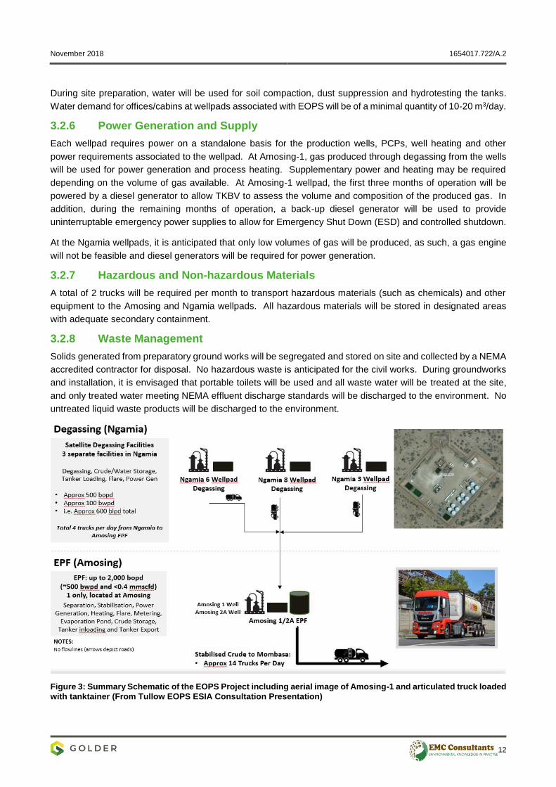
An Early Production Facility (EPF) will be located at the Amosing-1 wellpad to de-gas and stabilise the oil, before
being loaded into tanktainers and transported by road to KPRL facilities in Mombasa for storage and subsequent
sale on the international oil market. EOPS is planned to last approximately two years. The Project location is
presented in Figure 1 (Upstream and Midstream) and Figure 2 (Upstream) and summarised schematically in
Figure 3. Degassing, storage and truck loading facilities will be located in each of the Ngamia sites (Ngamia 3,
6 and 8)
November 2018 1654017.722/A.2
9
Figure 1: Upstream and Midstream Locations
November 2018 1654017.722/A.2
10
Figure 2: Upstream Location Plan
November 2018 1654017.722/A.2
11
3.1 Groundworks and Maintenance
Existing wellpad site preparation activities will require minor earthworks of grading, compaction and installation
of foundations for the equipment and drainage. Some groundworks and maintenance are permitted under the
existing exploration permits and will be undertaken in advance of EOPS and will take approximately 3 months
to complete.
Traffic movements and weathering at the existing wellpads and on the access roads may result in the road
surface becoming loose and rutted. Infield roads will therefore be re-graded and then re-compacted. The C46
road to the EPF at the Amosing-1 wellpad junction will be surfaced by KeNHA by laying a bitumen seal; a
process that is outside of the scope of the ESIA and has been permitted separately.
3.2 Infrastructure and Operation
3.2.1 Amosing-1: Early Production Facility (EPF) and Wellpad
A single EPF will be located at the Amosing-1 wellpad and will carry out the required processing of the produced
fluids from the Amosing production wells (Amosing-1 and Amosing-2A), plus the degassed fluids from the
Ngamia satellite degassing units. The incoming infield tankers from the Ngamia wellpads will offload the partially
stabilised crude/water into a storage tank at Amosing-1 wellpad, before being pumped into the EPF. The EPF
separates the water and stabilises the oil for storage. The produced water will be stored in a settling tank before
being pumped to an onsite evaporation pond at Amosing-1. The design is expected to utilise the available
produced gas for all power generation and process heating requirements. Any excess gas will be sent to a flare
at the Amosing-1 wellpad.
3.2.2 Amosing-5 Contingency Evaporation Wellpad
The evaporation capacity at the Amosing-1 evaporation pond is expected to be sufficient at the commencement
of the operations, however it might be necessary for excess produced water to go to an evaporation pond
located at the Amosing-5 wellpad.
3.2.3 Management of Produced Gas
Any excess gas at Amosing-1 that is not used for power generation will be sent to a vertical flare. At each of
the Ngamia wellpads all the associated gas will be sent to a vertical flare (9 metres high). There will be the
same Micoda vertical flares at all four locations, with one flare at each location. The flare system is designed
to safely dispose of hydrocarbon gases released from both the degassing wellpads and generated at the EPF
during both normal operation and under emergency situations.
3.2.4 Storage Tanks
There are nine existing crude storage tanks at the Amosing-1 wellpad, each of nominal 5,000 barrel capacity.
Of these, six will not be used for EOPS and three will be used for contingency storage or produced water
storage.
In addition, seven 400 barrel bitutainers will be installed at Amosing-1 wellpad. All the bitutainers will be the
primary storage for the processed crude, except one tank, which will also be used for temporary storage of
crude oil which does not meet the correct specification.
At the Ngamia wellpads, the existing and new crude storage tanks will be used as contingency storage if
required. At each Ngamia wellpad, there will be two bitutainers to which the degassed oil/water will flow.
3.2.5 Water
The water demand during site preparation will not exceed the existing permitted abstraction rates from existing
TKBV water boreholes (Nakukulas 9 and Ngamia East). The existing permit to abstract was approved by the
Water Resource Management Authority (WRMA) and will be valid for the duration of the EOPS Project.
November 2018 1654017.722/A.2
12
During site preparation, water will be used for soil compaction, dust suppression and hydrotesting the tanks.
Water demand for offices/cabins at wellpads associated with EOPS will be of a minimal quantity of 10-20 m3/day.
3.2.6 Power Generation and Supply
Each wellpad requires power on a standalone basis for the production wells, PCPs, well heating and other
power requirements associated to the wellpad. At Amosing-1, gas produced through degassing from the wells
will be used for power generation and process heating. Supplementary power and heating may be required
depending on the volume of gas available. At Amosing-1 wellpad, the first three months of operation will be
powered by a diesel generator to allow TKBV to assess the volume and composition of the produced gas. In
addition, during the remaining months of operation, a back-up diesel generator will be used to provide
uninterruptable emergency power supplies to allow for Emergency Shut Down (ESD) and controlled shutdown.
At the Ngamia wellpads, it is anticipated that only low volumes of gas will be produced, as such, a gas engine
will not be feasible and diesel generators will be required for power generation.
3.2.7 Hazardous and Non-hazardous Materials
A total of 2 trucks will be required per month to transport hazardous materials (such as chemicals) and other
equipment to the Amosing and Ngamia wellpads. All hazardous materials will be stored in designated areas
with adequate secondary containment.
3.2.8 Waste Management
Solids generated from preparatory ground works will be segregated and stored on site and collected by a NEMA
accredited contractor for disposal. No hazardous waste is anticipated for the civil works. During groundworks
and installation, it is envisaged that portable toilets will be used and all waste water will be treated at the site,
and only treated water meeting NEMA effluent discharge standards will be discharged to the environment. No
untreated liquid waste products will be discharged to the environment.
Figure 3: Summary Schematic of the EOPS Project including aerial image of Amosing-1 and articulated truck loaded
with tanktainer (From Tullow EOPS ESIA Consultation Presentation)
November 2018 1654017.722/A.2
13
3.3 Production
Profiles for oil production throughout EOPS have been estimated using two scenarios; one of high flow rate and
one of low flow rate. The ranges of the resultant oil, gas and water production from all EOPS facilities can be
summarised as follows:
Monthly oil production estimates range from 2000 barrels per day (bpd) to 1289 bpd;
Monthly gas production estimates range from 250 MSCF/d to 401 MSCF/d; and
Monthly water production estimates range from 37 bpd to 587 bpd.
3.4 Employment
There will be a total of 61 opportunities for employment as result of EOPS, which include 44 HGV drivers, 3
patrol of bus drivers, 6 administrators, assistant marshals or security personnel and 8 operations trainees.
3.5 Decommissioning
EOPS wellpads will be used for FFD where possible. Decommissioning and closure of FFD will comply with
international best practice, IFC Standards, NEMA requirements, Tullow’s environmental and social policies and
also Kenyan legislative and regulation requirements. As part of FFD, a Site Closure and Restoration Plan will
be developed.
3.6 Transportation
3.6.1 Infield Transportation (Upstream)
It is estimated that three road movements will occur each day to move Ngamia crude to the EPF at Amosing.
Infield tankers will use existing infield access roads and the existing section of the C46 road.
All workers that are accommodated at Kapese ISB or in local accommodation will be transported every day from
Kapese ISB to the wellpads (totalling 30 – 60 people for construction and 20 – 25 people during operations).
3.6.2 Oil Trucking to Mombasa (Midstream)
Special ISO-Tanktainers will be used to transport crude oil from the EPF to KPRL facilities in Mombasa.
Tanktainers have a maximum of 25,000 litres capacity (approximately 150 barrels of oil).
Routine loading for transportation is planned to be undertaken between 4pm and 6am, however, where
operationally necessary, loading may also take place during the day. All trucks will be parked at Amosing-1 or
the Ngamia wellpads.
It is anticipated that an average of 14 tanktainers per day will be used, 7 days a week, for a one-way journey.
This equates to an average of 28 road movements each day during EOPS along the proposed route shown in
Figure 1.
Vehicles will adhere to the designated speed limit for the roads being used by Project traffic. These are:
80 kmph on sealed national roads;
50 kmph on infield roads;
40 kmph on the Kapese ISB access road; and
10 kmph within wellpads.
There will be no routine driving on public roads at night related to oil exportation.
November 2018 1654017.722/A.2
14
4.0 ASSESSMENT OF ENVIRONMENTAL AND SOCIAL IMPACTS
4.1 Introduction
The following presents a summary of the analysis of impacts for EOPS, considering incorporated measures
identified, plus identifying any mitigation required.
4.2 Traffic
The standalone TIA focused on the route from Amosing to Eldoret. Baseline traffic counts on the section of the
route from Eldoret to Mombasa indicated that changes due to EOPS traffic in this area would be negligible.
Future baseline (2019) traffic counts were predicted and an impact assessment was based upon this. The
estimated change in truck movement was predicted to be less than 2% and it was concluded that EOPS will not
impact travel on the roads or result in a significant increase in the potential for vehicles to queue.
4.3 Soils, Terrain, Geology and Seismicity
Changes to terrain, geology or seismicity have been scoped out of this assessment as there are no potential
sources of effects on geology and seismicity resulting from EOPS.
Physical effects on soil due to EOPS will be minor and limited to the existing Project footprint during groundworks
and installation. Potential effects on soil characteristics and on the availability of soil as a resource are
considered to be negligible.
Only treated water meeting NEMA effluent discharge standards will be discharged to the soil during operations.
Therefore, the potential changes to soil as a result of accidental discharges are considered to be negligible.
The impacts of dust deposition are also considered to be negligible.
As such, all effects will result in a negligible impact classification.
4.4 Air Quality
The effects analysis for air quality was completed using various methods, including spreadsheet models and
specialised computer software, in order to predict the dispersion of emissions in the air. Predicted sources of
emissions from EOPS include flares, generators, gas engines and vehicle movements. Predicted sources of
dust from EOPS include those generated by groundworks and traffic movements. Meteorological data was
used in the computer model to describe the prevailing conditions.
The modelling predicted changes in emissions outside of the wellpad fencelines and concluded that there would
be negligible impacts outside the Ngamia wellpads and along the road route, however there would be some
(moderate) effects to air quality in the vicinity of the Amosing wellpad. Nevertheless, no human receptors will
be present directly outside Amosing, and no evidence of residential use was identified during land surveys,
therefore the impacts will be negligible.
Impacts on air quality due to EOPS traffic along the route are also predicted to be negligible.
4.5 Noise and Vibration
Vibration sources are considered to be negligible and therefore are scoped out of this assessment.
The effects analysis for noise was completed using different methods including specialised computer software
to predict noise propagation. Predicted noise sources from EOPS include flares, generators, gas engines,
pumps, heaters and vehicle movements. It was assumed that the 2 m earth bund surrounding the wellpads will
be maintained at 2 m, and noise generating equipment will be maintained for good performance throughout the
life of the Project.
November 2018 1654017.722/A.2
15
There will be noise effects due to groundworks and installation activities. The 2 m earth bund surrounding the
wellpads is expected to provide noise attenuation from the surrounding receptors.
During operations, the daytime international noise standards are exceeded in the vicinity of Amosing wellpad at
a distance of no further than 50 m from the fenceline. At night-time, the international standards are exceeded
at a distance of no further than 200 m from the fenceline.
During operations, the daytime international noise standards are not exceeded outside the fenceline at the
Ngamia wellpads. However, at night-time the international standards are exceeded at a distance of no further
than 100 m from the fenceline.
No human receptors will be present in these locations, and no evidence of residential use was identified during
land surveys, therefore the impacts are predicted to be minor or negligible. Impacts on noise and vibration due
to EOPS traffic along the route are predicted to be negligible.
Nevertheless, TKBV are committed to the following mitigation:
Groundworks and installation activities should occur during daylight hours and comply with noise
legislation; and
The 2 m bund surrounding each wellpad must be maintained at a height of 2 m prior to any groundworks
and installation and throughout operations and decommissioning.
4.6 Water Quantity
The effects of EOPS on water quantity have been analysed using spreadsheet models and professional
judgement. The potential sources of effects included groundworks intercepting groundwater, changes to
drainage, abstraction, discharge and flood risk. It is considered that, as the footprint of the wellpads will not
change, only very small volumes of water will be required, and acceptable water management practices will be
adhered to throughout the life of the Project; the impacts on water quantity are therefore considered to be
negligible.
4.7 Water Quality
The effects of EOPS on water quality have also been analysed using spreadsheet models and professional
judgement. The sources of effects included discharges from the wellpad and groundwater heating.
Groundwater temperatures could increase by 2oC at a distance of 50 m from the wellbore, which is a negligible
effect outside of the fenceline. Given that acceptable water management practices will be adhered to throughout
the life of the Project, impacts on water quality are considered to be negligible.
4.8 Landscape and Visual
Visual effects were assessed using specialised computer software and verified on site. The Project
infrastructure and lighting would be the main sources of visual effects. However, provided lighting effects are
managed on site, a negligible visual effect would occur as a result of EOPS as trees and scrubland form a
natural barrier to any visual effects.
4.9 Biodiversity, Ecology and Protected Areas
The biodiversity impact assessment considers the impacts on both habitats and species and considers both
direct and indirect effects from a multitude of different sources (e.g. noise, air quality, light).
Increased traffic could present a collision risk to certain ground-foraging bird species. These unmitigated
impacts are considered to be minor to moderate reflective of the differing sensitivities of different species.
November 2018 1654017.722/A.2
16
Similarly, unmitigated impacts to other raptors could result in possible mortality from the gas flares if an
appropriate start-up protocol is not in place. That is, individual raptors could be attracted to these flares.
Therefore, with suitable flare start-up procedures in place, the predicted impact significance is considered
moderate.
Moderate unmitigated impacts may also occur to identified raptor and vulture species as a result of drinking
water from evaporation ponds.
There are also moderate impacts anticipated to large mammals and bats as a result of site lighting potentially
affecting species movement patterns and foraging habitats.
TKBV are committed to a number of mitigation measures to address the impacts, including:
No hunting or collection of timber, flora and fauna by staff and/or contractors to be permitted;
Adoption of a start-up protocol for the flares so start up only occurs during daylight and ensure no perching
birds are present at start up;
A process for frequent checks for evidence of presence of birds across the wellpad, specifically around the
flare. Should mortality occur there will be a process in place for the review of operational practices, e.g.
flaring times; and
Effective wildlife exclusionary devices should be installed to prevent wildlife mortality. Netting is likely to be
the most effective method of keeping birds from entering produced water evaporation ponds.
4.10 Ecosystem Services
The ecosystem services impact assessment considers the impacts on local ‘beneficiaries’ (e.g. people,
businesses) relating to their livelihoods, health, safety, and/or culture, and considers both direct and indirect
impacts from a multitude of different sources (e.g. noise, air quality, water, cultural heritage).
The assessment concludes that there will be a moderate unmitigated impact during operation on grazing for
livestock, medicinal plants and biomass fuel. This could occur as a result of population influx.
TKBV are committed to mitigation measures to initiate an inventory and monitoring of grazing, biomass fuel,
wild food, livestock and medicinal plant use (to be developed prior to the implementation of FFD).
4.11 Social
The sources of economic effects relate to taxes and other payments, as well as employment and an increased
purchasing of goods and services. Impacts have again been considered across a range of topic areas, including
demographics; infrastructure and services; economics, employment and livelihoods; land use and ownership;
community health and safety; social maladies; social capital and conflict.
Moderate unmitigated impacts are predicted as a result of road traffic accidents from increased Project related
traffic; sexually transmitted diseases (including HIV) from increased salaried employment and an influx of
commercial sex workers; social maladies as a result of influx; and declining community cohesion as a result of
increased oil development in an area with very limited experience of industry.
TKBV are committed to a number of mitigation measures to address the impacts, including:
Tullow will commit to an information campaign on local employment opportunities;
Tullow will commit to a traffic safety campaign; and
Tullow will commit to an HIV policy and information campaign on Sexually Transmitted Diseases (STDs).
November 2018 1654017.722/A.2
17
4.12 Cultural Heritage
Cultural heritage occurs in both tangible and intangible forms:
Tangible cultural heritage is defined as moveable or immovable objects, property, sites, structures, or
groups of structures, having archaeological (prehistoric), paleontological, historical, cultural, artistic, and
religious values; or unique natural features or tangible objects that embody cultural values, such as sacred
groves, rocks, lakes, and waterfalls.
Intangible cultural heritage is described as elements of culture such as cultural knowledge, innovations,
and practices of communities embodying traditional lifestyles (IFC, 2012a).
As no additional land take is proposed, no new ground disturbance is anticipated, and so direct impacts to
cultural heritage sites are not predicted. The impact assessment does however consider indirect effects, such
as those resulting from visual, air quality and noise effects.
The assessment concludes negligible impacts upon cultural heritage assets as a result of EOPS. Minor impacts
are predicted on intangible elements of cultural heritage, reflective of their very high sensitivity.
4.13 Environmental Risks and Accidents
The environmental risks and accidents assessment included an evaluation of environmental and industrial
hazards and the probability of their occurrence. This was done in order to assess the risk of unplanned natural
and industrial events, which could result in environmental or social impacts by adversely affecting the
environment or public safety.
Although considered to be low probability unplanned events, vehicle collision causing death or injury (within the
wellpad), road traffic accidents causing an oil spill, spill of other hazardous materials or damage to public
infrastructure (on public roads), and emergency gas release from degassers, are considered to be a significant
risk, and road traffic accidents causing death, injury or damage to biodiversity receptors is considered to be a
high risk. Failure in the operation of the flare leading to unplanned emissions, natural seismicity (earthquakes),
heavy rainfall, high winds, flooding or extreme weather events are considered to be medium risks. All of these
will be managed under an Emergency Response Plan, Traffic Management Plan and Operational Management
Plan.
5.0 ASSESSMENT OF RESIDUAL IMPACTS
Through the adoption and implementation of the proposed mitigation measures, all adverse impacts have been
reduced to either minor or negligible. For Social, a number of initially negative impacts can, with the proposed
mitigation in place, result in positive benefits.
6.0 CUMULATIVE IMPACTS
No other major developments have been identified within the study area that have the potential to generate
cumulative impacts with the EOPS Project. However, the improvements being made to the transport route from
Amosing-1 to Eldoret may lead to cumulative effects. These other developments include the upgrade works on
the C46 road and development of rest stops on the transport route.
These are anticipated to result in improved access, leading to pressure on ecosystem services, influx and
migration and potential increases in sexually transmitted diseases, which must be managed using the Traffic
Management Plan and Social Management Plans.
November 2018 1654017.722/A.2
18
7.0 ENVIRONMENTAL AND SOCIAL MANAGEMENT PLAN
An Environmental and Social Management Plan (ESMP) compiles a set of management, mitigation and
monitoring measures to be taken during groundworks and installation, operation (including maintenance) and
decommissioning, in order to manage key potential environmental and social impacts identified in this ESIA.
The ESMP for EOPS includes the following sections, which will be developed into management plans and will
be “living documents”, to be updated as appropriate throughout operations:
Groundworks and Installation Management Plan;
Environmental Compliance Plan;
Water Management Plan;
Biodiversity Management Plan;
Social Management Plan;
Traffic and Transport Management Plan;
Hazardous Materials Management Plan; and
Emergency Preparedness and Response Plan.
Signature Page
Golder Associates (UK) Ltd
Harvey Rich Andrew Morsley
ESIA Project Coordinator ESIA Project Manager
Date: 27 November 2018
JLM/CR/AJM/TGF/HR/ES
Company Registered in England No.1125149
At Attenborough House, Browns Lane Business Park, Stanton-on-the-Wolds, Nottinghamshire NG12 5BL
VAT No. 209 0084 92
Golder and the G logo are trademarks of Golder Associates Corporation