River Systems and Drainage Basins Map reading activity lesson plan. Science Statements and Content Expectations E.ES.07.82 Analyze the flow of water between the components of a watershed, including surface features (lakes, streams, rivers, wetlands) and groundwater. Earth Science Literacy Principles’ Big Ideas- Big Idea 5: Earth is the water planet Misconceptions: Surface water can flow uphill. If a river appears to flow North/South on a map, North is uphill. Knowledge Needed/ Background Information: Students need previous knowledge on reading of topographic maps. Students need to have basic understanding of the water cycle. Key terms : Drainage basin: An area drained by a river system. Elevation: The height of a thing above a reference level; altitude. Precipitation: Any form of water, such as rain, snow, sleet, or hail, that falls to the earth's surface. Surface runoff: Rainfall not absorbed by soil. Topographic map: Graphic representation of the surface features of a place or region on a map, indicating their relative positions and elevations. Water cycle: The cycle of evaporation and condensation that controls the distribution of the earth's water as it evaporates from bodies of water, condenses, precipitates, and returns to those bodies of water. Also called hydrologic cycle.
Transcript
River Systems and Drainage Basins Map reading activity lesson plan.
Science Statements and Content Expectations
E.ES.07.82 Analyze the flow of water between the components of a watershed, including surface features (lakes, streams, rivers, wetlands) and groundwater.
Earth Science Literacy Principles’ Big Ideas- Big Idea 5: Earth is the water planet
Misconceptions: Surface water can flow uphill. If a river appears to flow North/South on a map, North is uphill.
Knowledge Needed/ Background Information: Students need previous knowledge on reading of topographic maps. Students need to have basic understanding of the water cycle.
Key terms :
Drainage basin: An area drained by a river system.
Elevation: The height of a thing above a reference level; altitude.
Precipitation: Any form of water, such as rain, snow, sleet, or hail, that falls to the earth's surface.
Surface runoff: Rainfall not absorbed by soil.
Topographic map: Graphic representation of the surface features of a place or region on a map, indicating their relative positions and elevations.
Water cycle: The cycle of evaporation and condensation that controls the distribution of the earth's water as it evaporates from bodies of water, condenses, precipitates, and returns to those bodies of water. Also called hydrologic cycle.
Materials needed:
Handout worksheet for the lesson.
Topographic maps of area around Kalamazoo river for Marshall, Saugatuck, Plainwell, and Kalamazoo. (One set for every group of 4 students)
Map of the Kalamazoo river.
Map of United States Rivers.
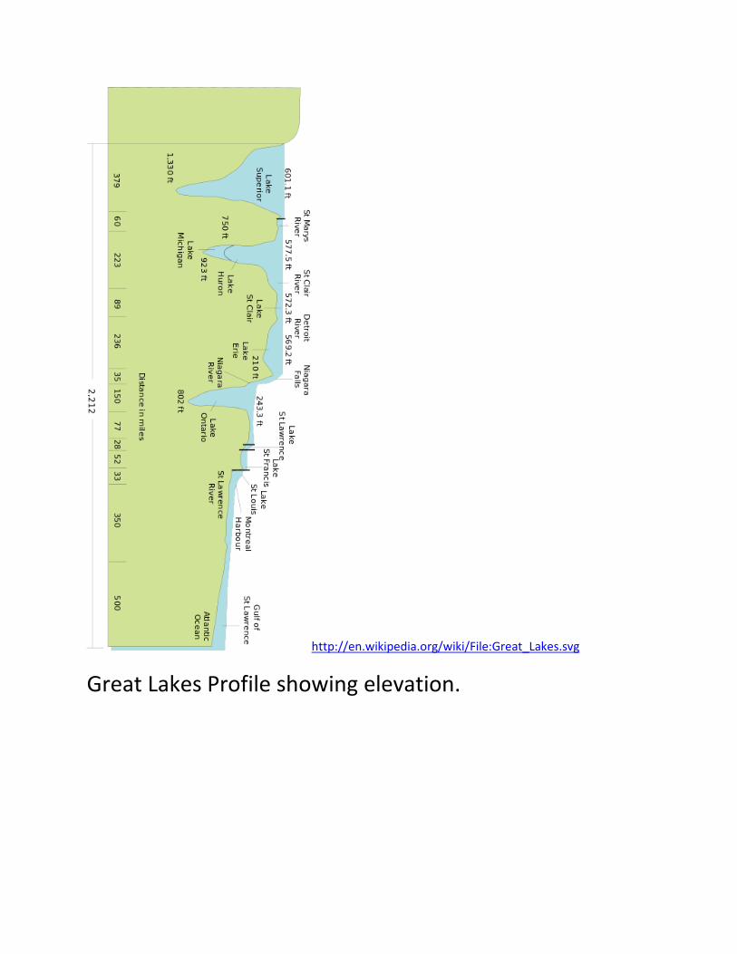
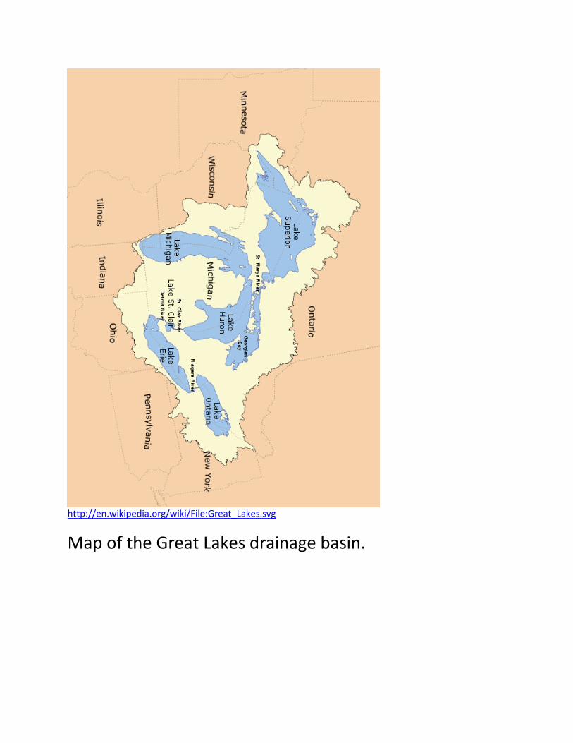
Map of Great Lakes and their profile of surface elevations.
Lesson
Engage (warm up)
Students work in groups of 4. Students observe a map of the United States for the Mississippi drainage basin. They first trace the Mississippi river then it’s tributaries to observe the size of the drainage basin. Then they identify three rivers on each side of the Mississippi river that drain into it. This is written on the first part of the handout/worksheet.
Explore
Students observe the map of the Kalamazoo river. They form a hypothesis of the direction it flows. Then they observe the topographic maps of 4 areas of the river to discover which way is downhill and where the river is flowing. Teacher rotates around the classroom to observe that students are reading the maps correctly and filling in the data chart on the handout/worksheet.
Explain
Clarify that there is water that infiltrates into the ground, evaporates, transpires from plants and is used by people and animals. What we are discovering today is what happens to surface water. Guide the students to recognize that water flows downhill. The next part should be discussed as a class after students have had a chance to think about it themselves.
Elaborate
Students then answer the questions on the handout worksheet. Water flows downhill. Infer where the Kalamazoo River starts and ends.
Evaluate: The responses on the handout/worksheet should agree with the map discoveries made in this lesson.
Extend: Students observe the maps of the Great Lakes. One is a birds-eye view and one is a profile showing surface elevations. Students need to observe the elevation of each Great Lake and infer that the water flows toward the Atlantic. On the hankout/ worksheet, they answer the following questions: Describe the direction the water flows. Explain where the water from the Kalamazoo river goes. Where does the Kalamazoo River get its water from? These answers should be discussed as a whole class after students have first explored them in their groups of 4.
Handout/ Worksheet:
River Systems and Drainage Basins Map reading activity
Observe the map of the rivers in the United States. Find the Mississippi River. It is the largest drainage basin in our country. Highlight this river. Now highlight the rivers that flow into it. (They must connect) Highlight any river that connects to the rivers you highlighted.
Find the Continental Divide. All water that lands here either drains into the Pacific (West) or Mississippi River (East) depending on which side of the Rocky Mountains it lands on. List at least 3 rivers that seem to flow from the Continental Divide to the Mississippi.___________________________________
____________________________________________________________________________________________________________________Find the Appalachian Mountains Water that lands here either drains into the Atlantic Ocean (East) or toward the Mississippi River (West) depending on which side of the mountains it lands on. List at least 3 rivers that seem to flow from the Appalachian Mountains to the Mississippi River.__________________________________________________________________________________________________________________________________________________________________________
Observe the topographic maps for the Kalamazoo River and complete the data chart below.
Map of Kalamazoo River at…
Elevation of the river (ft.)
Highest elevation in the area (drainage basin)
Lowest elevation in the area (drainage basin)
Saugatuck Otsego Kalamazoo Marshall
Water flows downhill. Infer where the Kalamazoo River starts and ends. What direction does it flow? ________________________________________________________________________________________________________________________________________________________________________________________________________________________________________
Observe the maps of the Great Lakes region. Describe the direction the water flows. (Toward or away from the ocean)
River Systems and Drainage Basins Map reading activity answer key
Observe the map of the rivers in the United States. Find the Mississippi River. It is the largest drainage basin in our country. Highlight this river. Now highlight the rivers that flow into it. (They must connect) Highlight any river that connects to the rivers you highlighted.
Find the Continental Divide. All water that lands here either drains into the Pacific (West) or Mississippi River (East) depending on which side of the Rocky Mountains it lands on. List at least 3 rivers that seem to flow from the Continental Divide to the Mississippi. Missouri, Yellowstone, Powder, North Platte, South Platte, Republican, Arkansas. Canadian, Red River, Brazos
Find the Appalachian Mountains Water that lands here either drains into the Atlantic Ocean (East) or toward the Mississippi River (West) depending on which side of the mountains it lands on. List at least 3 rivers that seem to flow from the Appalachian Mountains to the Mississippi River.
Observe the topographic maps for the Kalamazoo River and complete the data chart below.
Map of Kalamazoo River at…
Elevation of the river (ft.).
Highest elevation in the area (drainage basin)
Lowest elevation in the area (drainage basin)
Saugatuck 580 ft. 800 ft. 600 ft. Otsego 695 ft 800 ft. 700 ft. Kalamazoo 754 ft. 850 ft. 760 ft. Marshall 898 ft. 950 ft. 900 ft.
Water flows downhill. Infer where the Kalamazoo River starts and ends. What direction does it flow? The Kalamazoo river starts inland, east of Marshall and flows toward Saugatuck, northwest emptying into Lake Michigan.
Observe the maps of the Great Lakes region. Describe the direction the water flows. (Toward or away from the ocean)
Water in the Great Lakes flows from west to east toward the Atlantic Ocean.
Now explain where the water from the Kalamazoo river goes.
After water drains from the Kalamazoo river basin through the Kalamazoo river into Lake Michigan, it flows eastward. It goes through the straights of Macinac into Lake Huron. Then it goes south through the St. Clair river and Lake St. Clair and the Detroit river. Then it goes northeast through Lake Erie and the Niagra River, down Niagra Falls into Lake Ontario. Then it flows northeast through the St. Lawrence River and Seaway and into the Atlantic Ocean. (Provided there is no water diversion and the water does not evaporate, become groundwater, etc.)
Where does the Kalamazoo get its water from?
Kalamazoo gets its water from the Kalamazoo river drainage basin. Surface water (from precipitation in the water cycle such as rain, sleet, snow, and hail) that lands in parts of southwest Micigan flows to the Kalamazoo River.
Resources:
Maptech Terrain Navigator for Michigan: Southwest Kalamazoo Grand Rapids, www.maptech.com, 1998 Maptech, Inc.