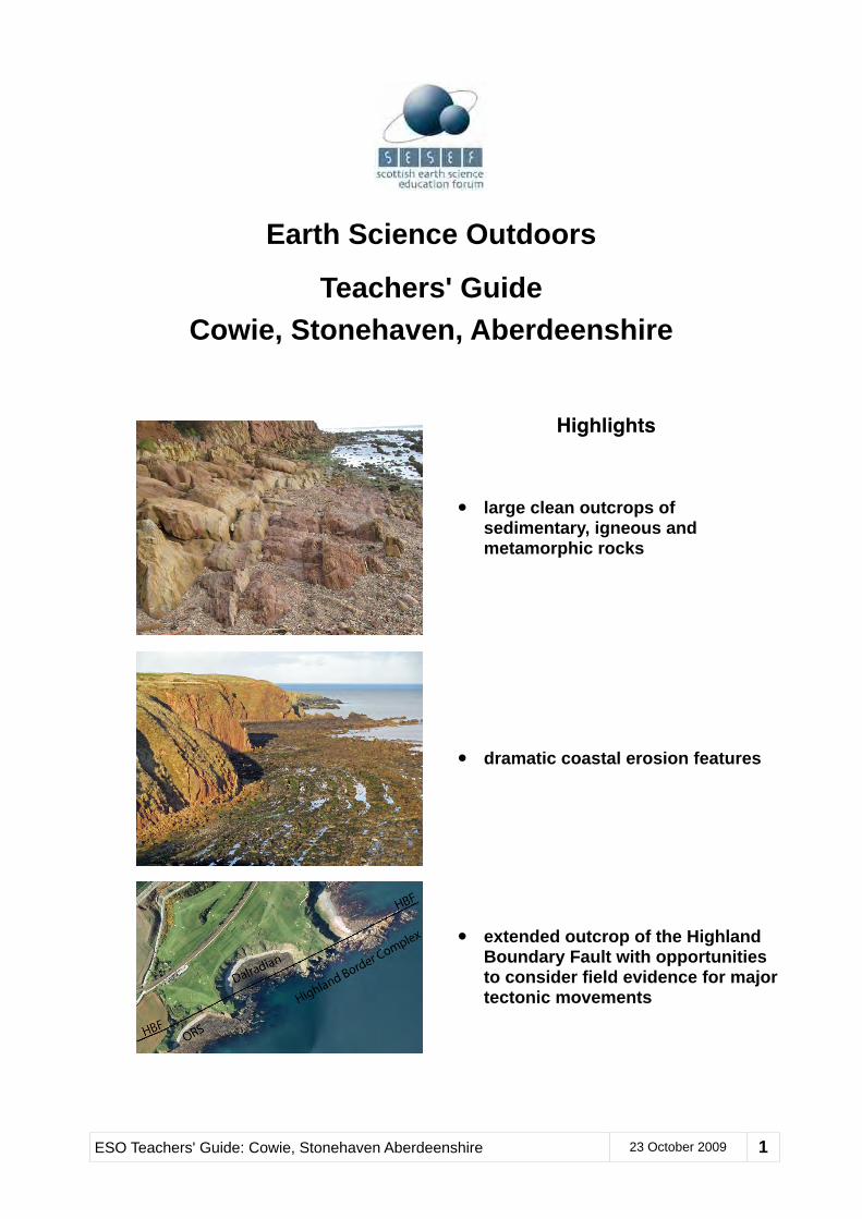
Earth Science Outdoors Teachers' Guide Cowie, Stonehaven, Aberdeenshire Highlights • large clean outcrops of sedimentary, igneous and metamorphic rocks • dramatic coastal erosion features • extended outcrop of the Highland Boundary Fault with opportunities to consider field evidence for major tectonic movements ESO Teachers' Guide: Cowie, Stonehaven Aberdeenshire 23 October 2009 1
Transcript
Earth Science Outdoors
Teachers' GuideCowie, Stonehaven, Aberdeenshire
Highlights
• large clean outcrops of sedimentary, igneous and metamorphic rocks
• dramatic coastal erosion features
• extended outcrop of the Highland Boundary Fault with opportunities to consider field evidence for major tectonic movements
ESO Teachers' Guide: Cowie, Stonehaven Aberdeenshire 23 October 2009 1
...........................................................................................................Is this field trip to Cowie for you?! 3.....................................................................................................................................Using this guide ! 4
.........................................................................................Suggestions for a Shortened Excursion! 4................................................................................................................Safety and Conservation! 6
......................................................................................................................Landscape Features! 8..............................................................................................................Other Features of Interest! 9
.....................................................................................Sources of Further Information & Support! 9......................................................................................Suggested Pre- and Post-visit Activities! 10
......................................................................................................................The Field Localities! 11..................................................................................................Location One: Lay-by Viewpoint! 11
............................................................................................Location Four: Steeply Tilted Strata! 14.................................................................................Location Five: Old Kirk Shore - South End! 15
...................................................................................Location Six: Old Kirk Shore - North End! 17..........................................................................................Location Seven: Old Cowie Kirkyard! 18
.....................................................................................................Location Eight: Ruthery Head! 19................................................................................Location Nine: Craigeven Bay - South End! 20
........................................................................................Location Ten: Craigeven Bay - Middle! 21.............................................................................Location Eleven: Craigeven Bay - North End! 21
....................................................................................................Location Twelve: Garron Point! 22.................................................................................................................Route back to car park! 23
IntroductionVisiting the coast immediately to the north of Stonehaven is a wonderful experience, especially in spring and early summer, and especially at low tide. Rocks are displayed that tell an amazing story of an ancient ocean that was destroyed by colliding continents whose edges were then buckled to form high mountains. Eroded debris from these mountains is seen side by side across the Highland Boundary Fault with rocks that were pushed downwards during the collision into hotter high pressure environments where they were greatly altered and deformed. The dramatic coastline also tells a geologically more recent story of rising and falling sea levels, and of coastal erosion.A unique insight into the lives of generations of people that have farmed and fished in this area is provided by the atmospheric cliff-top Chapel of Our Lady of the Storms and the surrounding Old Cowie Kirkyard. In season, wild flowers, birds and a range of other shoreline creatures and plants also add to the experience.If all twelve of the suggested localities are to be visited and examined in detail, then several hours will be required. Depending on the stamina and interests of the group members, visiting a limited selection of localities may be a more sensible target.Suggestions for a shortened version of the field excursion are outlined on page five of this guide. Even when tackling this shortened version, it will still be advisable for group leaders to familiarise themselves with the main points in the notes for each of the twelve described locations. This will ensure that they have the necessary background information for understanding the significance of the Highland Boundary Fault as seen from the final vantage point (Location Eight) overlooking Craigeven Bay. Note that the list of possible activities is relevant to any excursion.Bear in mind also that support for excursions in the form of trained leaders may be available. Refer to the Sources of Further Information and Support section below for further details.
Is this field trip to Cowie for you?The table below sets out information you may need when considering taking your pupils to Cowie:
Main aim: To explore the coast extending northwards from Cowie and to consider what the rocks, landforms and historical features can tell us about past environments, both geologically ancient and more recent.
This field trip and subsequent related classroom activities can provide excellent contexts for your pupils to develop a range of information handling, communication and collaborative skills. More specifically, it can help them to develop their curiosity and understanding of the environment and their place in the physical world. The physical environment at Cowie is well suited for helping pupils to address issues of assessing and managing risk with a view to protecting themselves and others.
Level 2 Level 3/4 Intermediate & Higher
Key CfE outcomes:
SOC 2-07a Explain how major landscape features were formed
SCN 2-17a Compare characteristics and uses of substances that make up Earth’s surface
MNU 2-20b Carry out surveys and communicate results in appropriate ways
Key CfE outcomes:SOC 3-07a Investigate processes which form and shape landscapesSCN 3-17a Describe the formation and characteristics of basic types of rocksSOC 3-14a Use maps and geographical information systems to gather, interpret and present conclusions
The submission of a fieldwork report is a requirement of final assessment at both Higher and Intermediate 2 Levels. Investigating the geology of this area will also support the following broad areas of study:minerals & rocks; structural geology & plate tectonics; isostacy; stratigraphy; Earth history
Earth Science topics that can be explored here include:• bays and headlands• changing coastlines• different kinds of rock and
how they are formed• how studying rocks and
fossils can give us information about past environments
• how the many past environments represented in Scotland’s rocks can be explained by plate movements
Earth Science topics that can be explored here include:• how the processes of erosion
and deposition create many different coastal features
• why outcrops of bedrock can only be seen in certain places
• how different kinds of sedimentary, metamorphic, and igneous rocks are formed
• how studying rock layers can give us valuable information about past environments
• how the many past environments represented in Scotland’s rocks can be explained in terms of plate tectonics
Geological features and topics that can be studied here include:• various outcrops of fluvial
sediments, dyke intrusions, low grade schists and altered ophiolites
• the Highland Boundary Fault and associated steeply dipping strata
• structural and stratigraphic relationships and their graphical representation
• changing physical environments, both ancient and modern
• coastal landforms and their formation
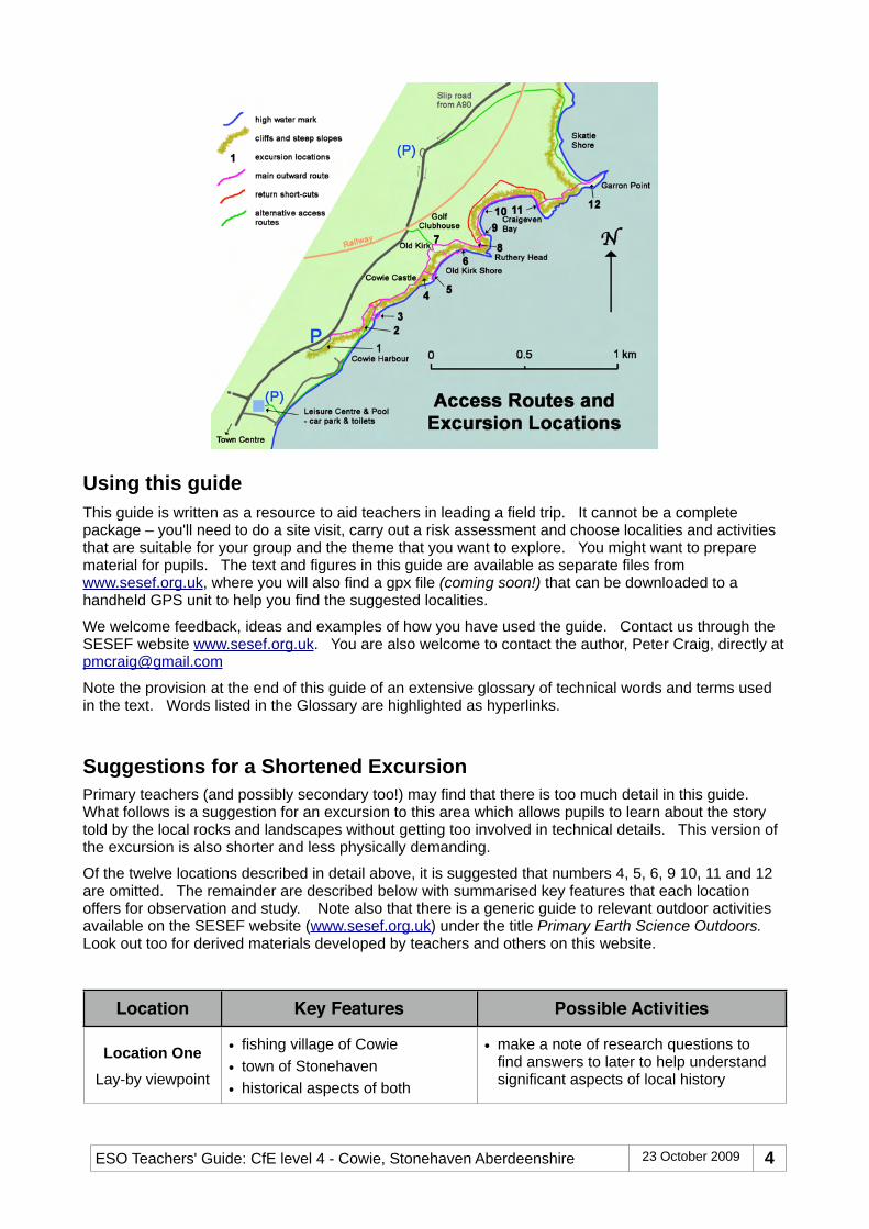
Suggested described locations to visit (see map on next page):1 - view of Stonehaven Bay from
lay-by2 - view wave-cut platform3 - rock outcrops on beach7 - Old Cowie kirkyard and
historical linkages8 - Ruthery Head with overview
of Highland Boundary Fault
Suggested described locations to visit (see map on next page):
1 to 12, possibly as two separate excursions
Locations 1 to 8 offer opportunities for studying sedimentary rock sequences, a dyke intrusion, post-glacial coastal erosion, ancient ocean basin rocks, an overview of the Highland Boundary Fault, and an insight into the lives of the inhabitants of Old Cowie
Locations 9 to 12 allow closer examination of the HBF and the three rock associations that are thrown into complex juxtaposition by it.
ESO Teachers' Guide: Cowie, Stonehaven Aberdeenshire 23 October 2009 3
Using this guideThis guide is written as a resource to aid teachers in leading a field trip. It cannot be a complete package – you'll need to do a site visit, carry out a risk assessment and choose localities and activities that are suitable for your group and the theme that you want to explore. You might want to prepare material for pupils. The text and figures in this guide are available as separate files from www.sesef.org.uk, where you will also find a gpx file (coming soon!) that can be downloaded to a handheld GPS unit to help you find the suggested localities.
We welcome feedback, ideas and examples of how you have used the guide. Contact us through the SESEF website www.sesef.org.uk. You are also welcome to contact the author, Peter Craig, directly at [email protected]
Note the provision at the end of this guide of an extensive glossary of technical words and terms used in the text. Words listed in the Glossary are highlighted as hyperlinks.
Suggestions for a Shortened ExcursionPrimary teachers (and possibly secondary too!) may find that there is too much detail in this guide. What follows is a suggestion for an excursion to this area which allows pupils to learn about the story told by the local rocks and landscapes without getting too involved in technical details. This version of the excursion is also shorter and less physically demanding.
Of the twelve locations described in detail above, it is suggested that numbers 4, 5, 6, 9 10, 11 and 12 are omitted. The remainder are described below with summarised key features that each location offers for observation and study. Note also that there is a generic guide to relevant outdoor activities available on the SESEF website (www.sesef.org.uk) under the title Primary Earth Science Outdoors. Look out too for derived materials developed by teachers and others on this website.
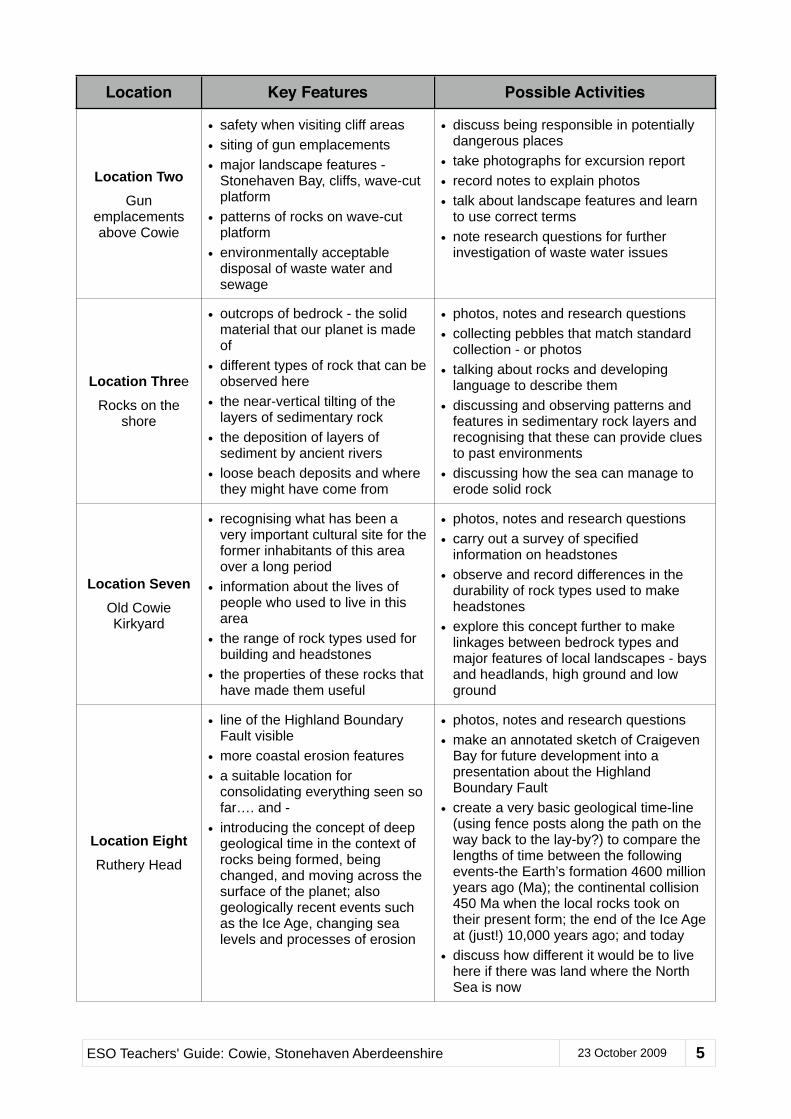
Location Key Features Possible Activities
Location OneLay-by viewpoint
• fishing village of Cowie• town of Stonehaven• historical aspects of both
• make a note of research questions to find answers to later to help understand significant aspects of local history
• safety when visiting cliff areas• siting of gun emplacements• major landscape features -
Stonehaven Bay, cliffs, wave-cut platform
• patterns of rocks on wave-cut platform
• environmentally acceptable disposal of waste water and sewage
• discuss being responsible in potentially dangerous places
• take photographs for excursion report• record notes to explain photos• talk about landscape features and learn
to use correct terms• note research questions for further
investigation of waste water issues
Location Three
Rocks on the shore
• outcrops of bedrock - the solid material that our planet is made of
• different types of rock that can be observed here
• the near-vertical tilting of the layers of sedimentary rock
• the deposition of layers of sediment by ancient rivers
• loose beach deposits and where they might have come from
• photos, notes and research questions• collecting pebbles that match standard
collection - or photos• talking about rocks and developing
language to describe them• discussing and observing patterns and
features in sedimentary rock layers and recognising that these can provide clues to past environments
• discussing how the sea can manage to erode solid rock
Location SevenOld Cowie Kirkyard
• recognising what has been a very important cultural site for the former inhabitants of this area over a long period
• information about the lives of people who used to live in this area
• the range of rock types used for building and headstones
• the properties of these rocks that have made them useful
• photos, notes and research questions• carry out a survey of specified
information on headstones• observe and record differences in the
durability of rock types used to make headstones
• explore this concept further to make linkages between bedrock types and major features of local landscapes - bays and headlands, high ground and low ground
Location EightRuthery Head
• line of the Highland Boundary Fault visible
• more coastal erosion features• a suitable location for
consolidating everything seen so far…. and -
• introducing the concept of deep geological time in the context of rocks being formed, being changed, and moving across the surface of the planet; also geologically recent events such as the Ice Age, changing sea levels and processes of erosion
• photos, notes and research questions• make an annotated sketch of Craigeven
Bay for future development into a presentation about the Highland Boundary Fault
• create a very basic geological time-line (using fence posts along the path on the way back to the lay-by?) to compare the lengths of time between the following events-the Earth’s formation 4600 million years ago (Ma); the continental collision 450 Ma when the local rocks took on their present form; the end of the Ice Age at (just!) 10,000 years ago; and today
• discuss how different it would be to live here if there was land where the North Sea is now
ESO Teachers' Guide: Cowie, Stonehaven Aberdeenshire 23 October 2009 5
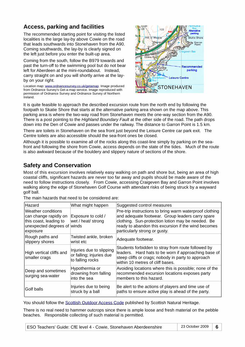
Access, parking and facilities The recommended starting point for visiting the listed localities is the large lay-by above Cowie on the road that leads southwards into Stonehaven from the A90. Coming southwards, the lay-by is clearly signed on the left just before you enter the built-up area.Coming from the south, follow the B979 towards and past the turn-off to the swimming pool but do not bear left for Aberdeen at the mini-roundabout. Instead, carry straight on and you will shortly arrive at the lay-by on your right.Location map: www.ordnancesurvey.co.uk/getamap. Image produced from Ordnance Survey's Get-a-map service. Image reproduced with permission of Ordnance Survey and Ordnance Survey of Northern Ireland.
It is quite feasible to approach the described excursion route from the north end by following the footpath to Skatie Shore that starts at the alternative parking area shown on the map above. This parking area is where the two-way road from Stonehaven meets the one-way section from the A90. There is a post pointing to the Highland Boundary Fault at the other side of the road. The path drops down into the Den of Cowie and passes under the railway. The distance to Garron Point is 1.5 km.There are toilets in Stonehaven on the sea front just beyond the Leisure Centre car park exit. The Centre toilets are also accessible should the sea-front ones be closed.Although it is possible to examine all of the rocks along this coast-line simply by parking on the sea-front and following the shore from Cowie, access depends on the state of the tides. Much of the route is also awkward because of the bouldery and slippery nature of sections of the shore.
Safety and ConservationMost of this excursion involves relatively easy walking on path and shore but, being an area of high coastal cliffs, significant hazards are never too far away and pupils should be made aware of the need to follow instructions closely. From Cowie, accessing Craigeven Bay and Garron Point involves walking along the edge of Stonehaven Golf Course with attendant risks of being struck by a wayward golf ball.The main hazards that need to be considered are:
Hazard What might happen Suggested control measuresWeather conditions can change rapidly on this coast, leading to unexpected degrees of exposure
Exposure to cold / wet / heat/ strong winds
Pre-trip instructions to bring warm waterproof clothing and adequate footwear. Group leaders carry spare clothing. Sun-protection lotion may be needed. Be ready to abandon this excursion if the wind becomes particularly strong or gusty.
Injuries due to slipping or falling; injuries due to falling rocks
Students forbidden to stray from route followed by leaders. Hard hats to be worn if approaching base of steep cliffs or crags; nobody in party to approach within 10 metres of cliff bases.
Deep and sometimes surging sea-water
Hypothermia or drowning from falling into the sea
Avoiding locations where this is possible; none of the recommended excursion locations exposes party members to this hazard.
Golf balls Injuries due to being struck by a ball
Be alert to the actions of players and time use of paths to ensure active play is ahead of the party.
You should follow the Scottish Outdoor Access Code published by Scottish Natural Heritage.
There is no real need to hammer outcrops since there is ample loose and fresh material on the pebble beaches. Responsible collecting of such material is permitted.
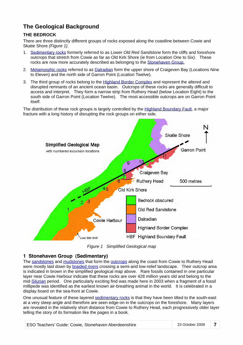
The Geological BackgroundTHE BEDROCKThere are three distinctly different groups of rocks exposed along the coastline between Cowie and Skatie Shore (Figure 1).1. Sedimentary rocks formerly referred to as Lower Old Red Sandstone form the cliffs and foreshore
outcrops that stretch from Cowie as far as Old Kirk Shore (ie from Location One to Six). These rocks are now more accurately described as belonging to the Stonehaven Group.
2. Metamorphic rocks referred to as Dalradian form the upper shore of Craigeven Bay (Locations Nine to Eleven) and the north side of Garron Point (Location Twelve).
3. The third group of rocks belong to the Highland Border Complex and represent the altered and disrupted remnants of an ancient ocean basin. Outcrops of these rocks are generally difficult to access and interpret. They form a narrow strip from Ruthery Head (below Location Eight) to the south side of Garron Point (Location Twelve). The most accessible outcrops are on Garron Point itself.
The distribution of these rock groups is largely controlled by the Highland Boundary Fault, a major fracture with a long history of disrupting the rock groups on either side.
Figure 1 Simplified Geological map
1 Stonehaven Group (Sedimentary)The sandstones and mudstones that form the outcrops along the coast from Cowie to Ruthery Head were mostly laid down by braided rivers crossing a semi-arid low-relief landscape. Their outcrop area is indicated in brown in the simplified geological map above. Rare fossils contained in one particular layer near Cowie Harbour indicate that these rocks are over 428 million years old and belong to the mid-Silurian period. One particularly exciting find was made here in 2003 when a fragment of a fossil millipede was identified as the earliest known air-breathing animal in the world. It is celebrated in a display board on the sea-front at Cowie.One unusual feature of these layered sedimentary rocks is that they have been tilted to the south-east at a very steep angle and therefore are seen edge-on in the outcrops on the foreshore. Many layers are revealed in the relatively short distance from Cowie to Ruthery Head, each progressively older layer telling the story of its formation like the pages in a book.
ESO Teachers' Guide: Cowie, Stonehaven Aberdeenshire 23 October 2009 7
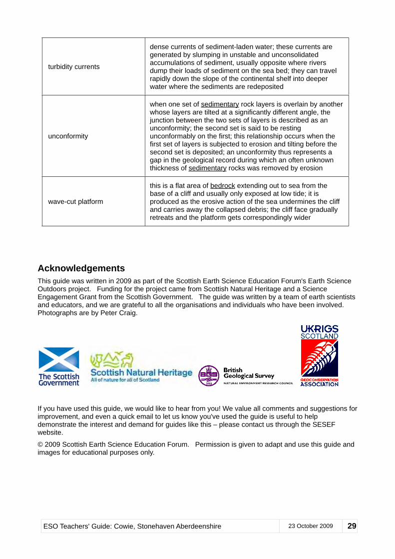
Near Ruthery Head, the very earliest layer in the sequence can be examined. It is distinctly coarser-grained and made up of rock fragments and pebbles set in a purplish brown matrix. This basal layer of the Stonehaven Group lies directly on top of similarly coloured and weathered slaty rocks of the Highland Border Complex. The relationship is described as an unconformable one, meaning that the surface of the Highland Border Complex was one that had been eroded and weathered for some considerable time before the basal layer of the Stonehaven Group was deposited on top of it. Like the succeeding layers of sedimentary rock, this surface is now steeply tilted at an angle of around 75 degrees from the horizontal towards the SSE.
2 Dalradian (Metamorphic)The final of the three rock groups is commonly referred to as Dalradian and is indicated by the purple colour in the map above. Outcrops of Dalradian rocks occur along all of the NE coastline round into the Moray Firth as far as Buckie. They also stretch south-westwards across Scotland all the way to Argyll. They consist of what were once varied sequences many kilometres thick of sedimentary and volcanic rocks laid down during the Pre-Cambrian era more than 500 million years ago. Around 470 million years ago, they were exposed to elevated temperatures and pressures during a major continental collision, transforming most of them to metamorphic schists, gneisses, quartzites, marbles and slates. These rocks are intruded by granites the youngest of which are almost 415 million years old. At Craigeven Bay and Skatie Shore, the Dalradian rocks are represented by mostly fine-grained metamorphosed sedimentary rocks which occasionally show clear evidence of compression and folding.
3 Highland Border ComplexSeveral different rock types are present within the Highland Border Complex and all are typical of those formed on deep ocean floors. They are represented by the pinkish red colour in the map above. The dominant type is termed pillow lava and is formed when volcanic eruptions occur under water, often where new crustal rock is being added to the edge of developing tectonic plates. Also present locally are thin layers of black mudstone. Red jasper and other types of chert are also found in these rocks. They were originally formed as layers and patches of gel on the sea-bed when silica and other chemicals were precipitated from sea-water in volcanically active areas. Golden coloured iron pyrites may also be spotted, its presence usually indicated by extensive localised rusty weathering.
Unfortunately, nearly all of the readily accessible outcrops of Highland Border Complex rocks between Ruthery Head and Garron Point are so altered that these rock types are very difficult to recognise and distinguish, even to the experienced eye. There are a few convincing outcrops that can be reached at low tide and with considerable rock scrambling agility, but these are not included in the list of described locations in this excursion guide.
Highland Boundary FaultThe main geological feature for which this stretch of coast-line is famous is of course the Highland Boundary Fault, shown in the map above as a heavy black line separating the Dalradian rocks from the Highland Border Complex and the Stonehaven Group. It marks a line of fracture across which considerable movements have occurred in various directions at various times within the last several hundred million years. At Craigeven Bay, there is a band of distinctively orange coloured rock occupying the near-vertical fault zone. It appears to be a dislocated slice of highly altered rock (carbonated serpentinite) belonging to the Highland Border Complex.
At the time that these rocks were being moved into their present configuration, around 420 million years ago, Scotland lay somewhat south of the equator in a land-locked semi-arid environment and formed part of the continent of Laurentia. The imperceptibly slow but immensely powerful collision of three continents (Laurentia, Baltica and Avalonia) created the crumpled Dalradian metamorphic rocks, amongst others, and closed the ocean that formerly existed between them. The Highland Border Complex rocks between Ruthery Head and Garron Point represent one of the few preserved remnants of the rocks that lay beneath part of this ancient ocean.
LANDSCAPE FEATURESThis stretch of coastline has spectacular examples of wave-cut platforms. These are the flat-lying expanses of largely sea-weed covered rocks that stretch out to sea from the bases of the cliffs. When viewed from the cliff-tops at low tide, every detail of the patterns of layering in the Stonehaven Group is revealed. As is witnessed by the land-slip scarred cliffs, landward erosion is proceeding apace as the
sea first undercuts the cliffs and then removes the fallen debris. As this process continues, the former cliff foundations are worn down to add to the width of the wave-cut platforms.
Glacial till left on top of the land surface by retreating ice sheets after the last glaciation makes up the higher parts of the cliffs and is particularly prone to slippage. It may also be found at the base of cliffs that are not being actively eroded by the sea.
OTHER FEATURES OF INTERESTThe Old Cowie Kirkyard and its ruined Chapel of Our Lady of the Storms provide a wonderful opportunity for studying and reflecting on the lives of the people that used to live in this area. The large number of grave stone inscriptions contain historically interesting information as well as revealing insights into the lives of individuals. Many different aspects of the kirkyard lend themselves to the practice of both factual and artistic recording techniques.
The ecology of this coastal zone has many interesting features. The contrast in vegetation between cliff-top sites exposed to the full blast of gales and sheltered sites at lower levels is very marked. Sheltered wet gullies also support different plant assemblages from other areas. Areas of thick vegetation like this provide feeding and nesting areas for small birds. Depending on the season and the state of the tides, sea-birds and seals may be observed. Shellfish and sea-weeds of various types can be examined in the tidal zone.
Sources of Further Information & SupportMore information about this period in Scotland’s geological past can be found by interacting with the Geological Time Scale at:
and by reading the Midland Valley section of the Regional Geology pages on the same website.
The information summarised above is partly derived from this and other websites (see below) and from the BGS publication Bedrock Geology UK North (ISBN-13: 978-0751835021).
For support when planning a group visit to Cowie, please contact the Scottish Earth Science Education Forum (SESEF) to check if a local facilitator is available to accompany your group. SESEF’s contact details are:
At the time of writing (June 2009), the SESEF development Officer is Catherine Morgan. Another person to contact for help in planning a visit is the Aberdeenshire Kincardine and Mearns Ranger who can be contacted at:
You are also welcome to contact the author, Peter Craig, directly at [email protected]
The key features of this site are:
• clean upper shore outcrops that display successive layers of sedimentary rocks• features in the Stonehaven Group beds that provide evidence of their origins• extensive wave-cut platforms displaying structural patterns in near-vertical
Stonehaven Group strata• glimpses of ancient metamorphic and deep ocean rocks• outcrops showing the line of the Highland Boundary Fault• Dalradian metamorphic rocks• evidence of plate tectonics in action.
ESO Teachers' Guide: Cowie, Stonehaven Aberdeenshire 23 October 2009 9
Suggested Pre- and Post-visit Activities1. Explore Scotland's rocks and your local rocks. Experiment to discover the resistance of different
rock types to erosion.
2. Study landforms and erosional processes in modern mountain ranges in arid climates.
3. Visit the University of Texas website (see the section above headed Sources of Additional Information and Support) and study reconstructed plate movements from around 450 to 350 million years ago, paying particular attention to the area that became the UK.
4. Study Google Earth or similar satellite images of the coast of this part of Aberdeenshire and Angus and look for correlations between landforms and local rock types as shown on geological maps of the same area (eg http://www.scottishgeology.com/geology/geology_of_scotland_map/scotland.html)
One of the clearest on-line aerial images of this area can be found on the People’s Map accessed by clicking on the Photo button on this web page:
5. The range of topics and issues raised during a field excursion like this is likely to be extensive. It will obviously be desirable to explore and consolidate understanding of these topics and issues after the excursion through research activities, discussions and presentations.
6. To help understand more about the HIghland Boundary Fault, comparisons could be made with modern examples such as the San Andreas Fault. Researches could start with the Geology.com article at http://geology.com/articles/san-andreas-fault.shtml or the Wikipedia entry at http://en.wikipedia.org/wiki/San_Andreas_Fault. Stunning images can also be viewed using a Google Images search. A very simple experiment using a toffee bar (long flat types are best) provides an analogy of the conditions under which rocks can either deform or fracture. If the toffee bar is pre-chilled, it will be brittle and quickly snap (fracture) when you try to bend it. If it is at room temperature, or if bending forces are applied very slowly, it is more likely to bend (fold). Rocks also respond differently to deforming forces depending on temperatures and the rates of change of the forces’ directions and strengths. Refer also to the Activities For All Ages resource on the SESEF website - http://www.sesef.org.uk/.
For more comprehensive and technical details about the geology of the Stonehaven coastal section, there are now two excellent online sources. Updated chapters of the Excursion Guide to the Geology of the Aberdeen Area are now accessible in digital format to members of the Aberdeen Geological Society at:
Look for the Movies section on this rather crowded webpage and then for PLATES 2002 Atlas of Plate Reconstructions (750 Ma to Present Day). This link downloads a Powerpoint presentation showing plate movements in some detail, including those at the time of the formation of the rocks of the Stonehaven area.
Location One: Lay-by ViewpointIt is worth taking a few minutes to take in the historical context of the Stonehaven area from the vantage point afforded by the parking lay-by. The modern town of Stonehaven stretches off to the south while, tucked in at the bottom of the cliff, immediately below the lay-by, lies the old fishing village of Cowie. Long before Stonehaven existed in its present form, Cowie was an important Royal Burgh established by the Scottish king Malcolm Canmore who reigned from about 1057 to 1093. He is also believed to have built Cowie Castle which was strategically placed to control access to the Causey Mounth, an ancient raised trackway crossing the rough and boggy terrain northwards to Aberdeen.
The original village of Cowie was located on the hillside to the north of the lay-by. Along with other local settlements, it was destroyed in 1645 when the Marquis of Montrose laid waste to the area as part of his Royalist campaign against the Covenanters, one of whose leaders was the local laird. When the village was eventually rebuilt, it was relocated on its present site down on the shore next to the lay-by.
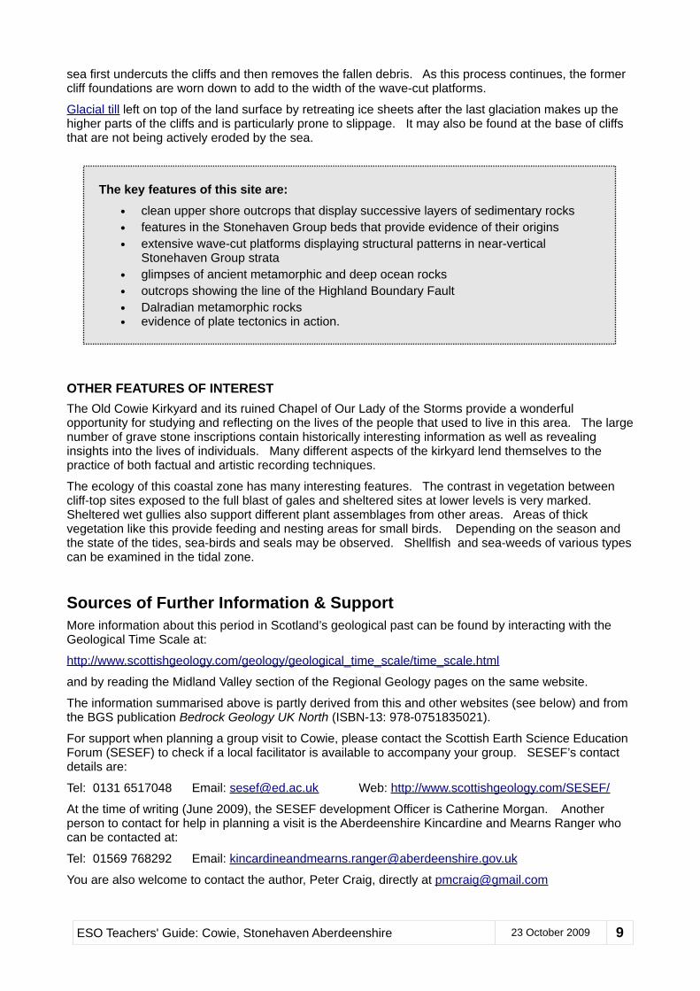
Location Two: Gun Emplacements Above CowieTake the path from the north end of the lay-by and follow it along the cliff-top path for about 130 metres. This will bring you to the ruins of gun emplacements (Figure 2), about which very little reliable information has been found. They make a convenient first stop on this excursion to take in the impressive overview of the rock outcrops and coastal features spread out below. A good way to start this excursion is to ask your group to have a good look at everything they can see from this vantage point and describe each of the rock and landscape features observed. Provided the excursion takes place at or near low tide, these might include the following:
Figure 2 Gun emplacements
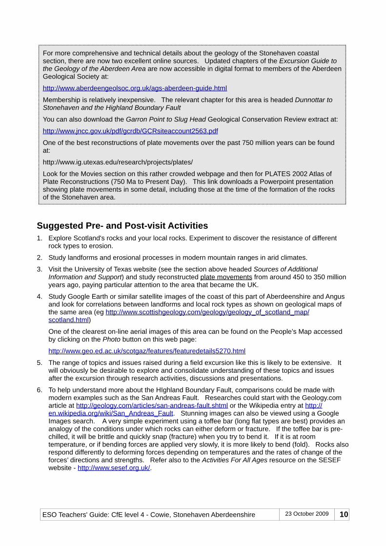
• Wave-cut platform This is perhaps the most obvious feature at low tide. The term refers to the gently sloping rock surface that extends sea-wards from the base of the cliffs (Figure 3). It is created by the long-term erosion of cliffs as wave action undermines them and then removes the collapsed rock debris. This wave-cut platform is very unusual because it is cut across a sequence of sedimentary strata that have been tilted until they are almost vertical. Most groups will be able to recognise that the rocks in the platform are layered and are therefore likely to be sedimentary. Fewer will be able to interpret what they see immediately as vertically tilted strata. This could make for a good discussion of the possibilities which will only be fully resolved when they visit Location Two down on the shore.
Figure 3 Wave-cut platform and eroding cliffs
ESO Teachers' Guide: Cowie, Stonehaven Aberdeenshire 23 October 2009 11
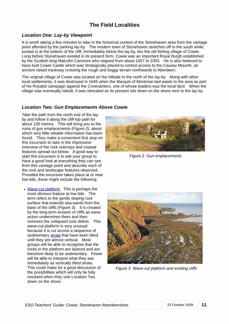
• Cross-cutting igneous dykes This feature is less obvious and your group may need guidance to be able to spot it. However, looking down and to the left, it should be possible to observe a group of outcrops in the wave-cut platform where the regular pattern of layering is absent (Figure 4). The reason for this interruption of the otherwise ubiquitous layering along this stretch of coast is that some magma has been intruded vertically into the strata to form at least two dykes of igneous rock. This igneous rock is more resistant to erosion and persists out to sea as more upstanding outcrops than those formed by the adjacent sedimentary strata. Again, this feature will be the subject of closer examination at Location Two. Figure 4 View of dyke outcrops from cliff-top
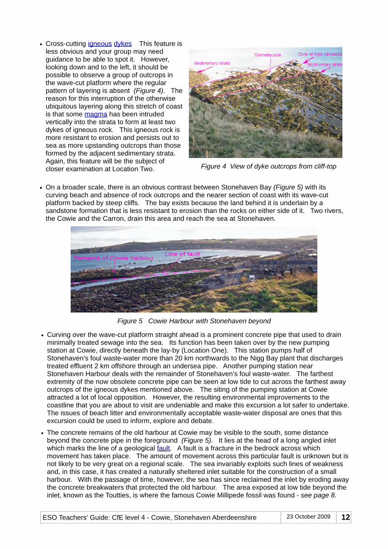
• On a broader scale, there is an obvious contrast between Stonehaven Bay (Figure 5) with its curving beach and absence of rock outcrops and the nearer section of coast with its wave-cut platform backed by steep cliffs. The bay exists because the land behind it is underlain by a sandstone formation that is less resistant to erosion than the rocks on either side of it. Two rivers, the Cowie and the Carron, drain this area and reach the sea at Stonehaven.
Figure 5 Cowie Harbour with Stonehaven beyond
• Curving over the wave-cut platform straight ahead is a prominent concrete pipe that used to drain minimally treated sewage into the sea. Its function has been taken over by the new pumping station at Cowie, directly beneath the lay-by (Location One). This station pumps half of Stonehaven’s foul waste-water more than 20 km northwards to the Nigg Bay plant that discharges treated effluent 2 km offshore through an undersea pipe. Another pumping station near Stonehaven Harbour deals with the remainder of Stonehaven’s foul waste-water. The farthest extremity of the now obsolete concrete pipe can be seen at low tide to cut across the farthest away outcrops of the igneous dykes mentioned above. The siting of the pumping station at Cowie attracted a lot of local opposition. However, the resulting environmental improvements to the coastline that you are about to visit are undeniable and make this excursion a lot safer to undertake. The issues of beach litter and environmentally acceptable waste-water disposal are ones that this excursion could be used to inform, explore and debate.
• The concrete remains of the old harbour at Cowie may be visible to the south, some distance beyond the concrete pipe in the foreground (Figure 5). It lies at the head of a long angled inlet which marks the line of a geological fault. A fault is a fracture in the bedrock across which movement has taken place. The amount of movement across this particular fault is unknown but is not likely to be very great on a regional scale. The sea invariably exploits such lines of weakness and, in this case, it has created a naturally sheltered inlet suitable for the construction of a small harbour. With the passage of time, however, the sea has since reclaimed the inlet by eroding away the concrete breakwaters that protected the old harbour. The area exposed at low tide beyond the inlet, known as the Toutties, is where the famous Cowie Millipede fossil was found - see page 8.
Location Three: Igneous Dykes and Sedimentary StrataContinue along the cliff-top path from the gun emplacements for 130 metres and take the first path that descends one of the many grassy gullies. Bear right where this path meets another to head down to the shore. On your right, before you reach the shore itself, you will note a large rocky outcrop that forms a prominent feature rising steeply quite close to the path. It is not really worth scrambling up to examine this outcrop since the same rock can be seen more safely on the beach below. Even from a distance, however, it is obvious that there is no sign of any layering in this rock and you may be able to make out its pitted surface.
At the path’s lowest point, head down the last few metres on to the shore. This short section can be muddy and slippery in wet weather.
Give your group some time to examine the relatively clean outcrops near the high water mark within a radius of about 35 metres of where you accessed the shore. Ask them to describe the rock types they observe in these outcrops, making sure first that they understand the distinction between bedrock outcrops and the loose pebbles and boulders that litter the shore. Although most of the loose rocks are derived from the immediately local bedrock, many others have been transported along the shore by wave action from other locations. Some may also have been carried for some distance by ice movements. While examining the variety of pebbles is not the main purpose of visiting this locality, if time permits, it is a good location for carrying out a pebble-matching activity. Details of different ways of tackling such an activity are given under the heading Every pebble tells a story on page 20 of the ESO Teachers’ Guide to Crawton. This guide (and many others) are available for download from the SESEF website at http://www.sesef.org.uk/. Just follow the View a list of online resources link.
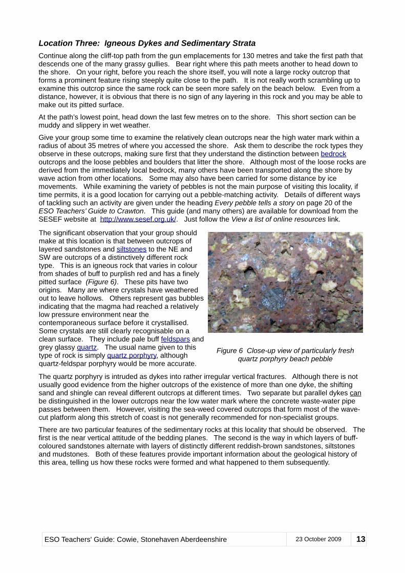
The significant observation that your group should make at this location is that between outcrops of layered sandstones and siltstones to the NE and SW are outcrops of a distinctively different rock type. This is an igneous rock that varies in colour from shades of buff to purplish red and has a finely pitted surface (Figure 6). These pits have two origins. Many are where crystals have weathered out to leave hollows. Others represent gas bubbles indicating that the magma had reached a relatively low pressure environment near the contemporaneous surface before it crystallised. Some crystals are still clearly recognisable on a clean surface. They include pale buff feldspars and grey glassy quartz. The usual name given to this type of rock is simply quartz porphyry, although quartz-feldspar porphyry would be more accurate.
The quartz porphyry is intruded as dykes into rather irregular vertical fractures. Although there is not usually good evidence from the higher outcrops of the existence of more than one dyke, the shifting sand and shingle can reveal different outcrops at different times. Two separate but parallel dykes can be distinguished in the lower outcrops near the low water mark where the concrete waste-water pipe passes between them. However, visiting the sea-weed covered outcrops that form most of the wave-cut platform along this stretch of coast is not generally recommended for non-specialist groups.
There are two particular features of the sedimentary rocks at this locality that should be observed. The first is the near vertical attitude of the bedding planes. The second is the way in which layers of buff-coloured sandstones alternate with layers of distinctly different reddish-brown sandstones, siltstones and mudstones. Both of these features provide important information about the geological history of this area, telling us how these rocks were formed and what happened to them subsequently.
ESO Teachers' Guide: Cowie, Stonehaven Aberdeenshire 23 October 2009 13
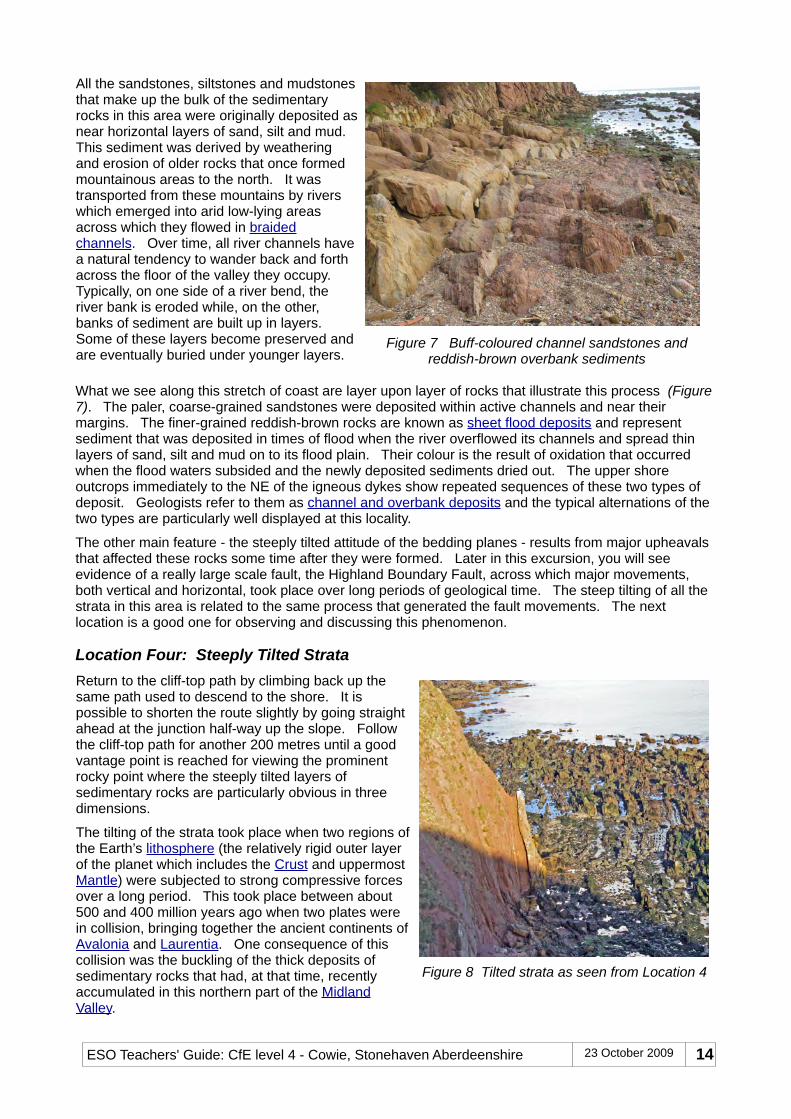
All the sandstones, siltstones and mudstones that make up the bulk of the sedimentary rocks in this area were originally deposited as near horizontal layers of sand, silt and mud. This sediment was derived by weathering and erosion of older rocks that once formed mountainous areas to the north. It was transported from these mountains by rivers which emerged into arid low-lying areas across which they flowed in braided channels. Over time, all river channels have a natural tendency to wander back and forth across the floor of the valley they occupy. Typically, on one side of a river bend, the river bank is eroded while, on the other, banks of sediment are built up in layers. Some of these layers become preserved and are eventually buried under younger layers.
Figure 7 Buff-coloured channel sandstones and reddish-brown overbank sediments
What we see along this stretch of coast are layer upon layer of rocks that illustrate this process (Figure 7). The paler, coarse-grained sandstones were deposited within active channels and near their margins. The finer-grained reddish-brown rocks are known as sheet flood deposits and represent sediment that was deposited in times of flood when the river overflowed its channels and spread thin layers of sand, silt and mud on to its flood plain. Their colour is the result of oxidation that occurred when the flood waters subsided and the newly deposited sediments dried out. The upper shore outcrops immediately to the NE of the igneous dykes show repeated sequences of these two types of deposit. Geologists refer to them as channel and overbank deposits and the typical alternations of the two types are particularly well displayed at this locality.
The other main feature - the steeply tilted attitude of the bedding planes - results from major upheavals that affected these rocks some time after they were formed. Later in this excursion, you will see evidence of a really large scale fault, the Highland Boundary Fault, across which major movements, both vertical and horizontal, took place over long periods of geological time. The steep tilting of all the strata in this area is related to the same process that generated the fault movements. The next location is a good one for observing and discussing this phenomenon.
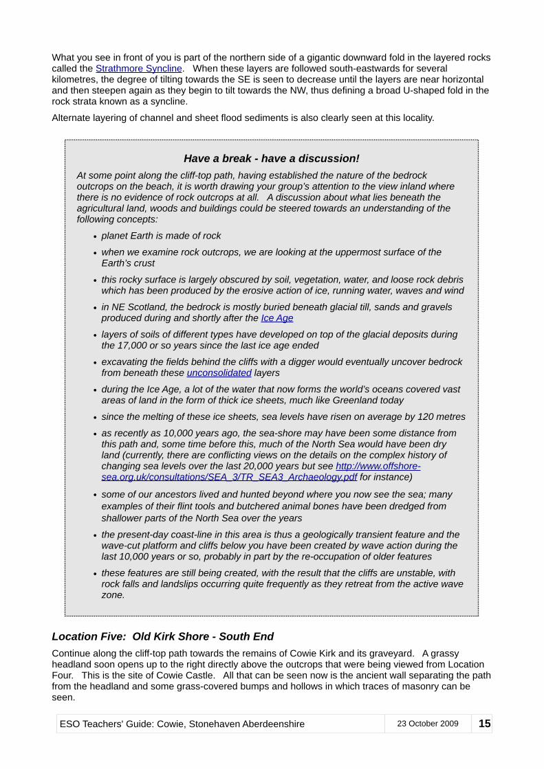
Location Four: Steeply Tilted StrataReturn to the cliff-top path by climbing back up the same path used to descend to the shore. It is possible to shorten the route slightly by going straight ahead at the junction half-way up the slope. Follow the cliff-top path for another 200 metres until a good vantage point is reached for viewing the prominent rocky point where the steeply tilted layers of sedimentary rocks are particularly obvious in three dimensions.
The tilting of the strata took place when two regions of the Earth’s lithosphere (the relatively rigid outer layer of the planet which includes the Crust and uppermost Mantle) were subjected to strong compressive forces over a long period. This took place between about 500 and 400 million years ago when two plates were in collision, bringing together the ancient continents of Avalonia and Laurentia. One consequence of this collision was the buckling of the thick deposits of sedimentary rocks that had, at that time, recently accumulated in this northern part of the Midland Valley.
What you see in front of you is part of the northern side of a gigantic downward fold in the layered rocks called the Strathmore Syncline. When these layers are followed south-eastwards for several kilometres, the degree of tilting towards the SE is seen to decrease until the layers are near horizontal and then steepen again as they begin to tilt towards the NW, thus defining a broad U-shaped fold in the rock strata known as a syncline.
Alternate layering of channel and sheet flood sediments is also clearly seen at this locality.
Location Five: Old Kirk Shore - South EndContinue along the cliff-top path towards the remains of Cowie Kirk and its graveyard. A grassy headland soon opens up to the right directly above the outcrops that were being viewed from Location Four. This is the site of Cowie Castle. All that can be seen now is the ancient wall separating the path from the headland and some grass-covered bumps and hollows in which traces of masonry can be seen.
Have a break - have a discussion!At some point along the cliff-top path, having established the nature of the bedrock outcrops on the beach, it is worth drawing your group’s attention to the view inland where there is no evidence of rock outcrops at all. A discussion about what lies beneath the agricultural land, woods and buildings could be steered towards an understanding of the following concepts:
• planet Earth is made of rock
• when we examine rock outcrops, we are looking at the uppermost surface of the Earth’s crust
• this rocky surface is largely obscured by soil, vegetation, water, and loose rock debris which has been produced by the erosive action of ice, running water, waves and wind
• in NE Scotland, the bedrock is mostly buried beneath glacial till, sands and gravels produced during and shortly after the Ice Age
• layers of soils of different types have developed on top of the glacial deposits during the 17,000 or so years since the last ice age ended
• excavating the fields behind the cliffs with a digger would eventually uncover bedrock from beneath these unconsolidated layers
• during the Ice Age, a lot of the water that now forms the world’s oceans covered vast areas of land in the form of thick ice sheets, much like Greenland today
• since the melting of these ice sheets, sea levels have risen on average by 120 metres
• as recently as 10,000 years ago, the sea-shore may have been some distance from this path and, some time before this, much of the North Sea would have been dry land (currently, there are conflicting views on the details on the complex history of changing sea levels over the last 20,000 years but see http://www.offshore-sea.org.uk/consultations/SEA_3/TR_SEA3_Archaeology.pdf for instance)
• some of our ancestors lived and hunted beyond where you now see the sea; many examples of their flint tools and butchered animal bones have been dredged from shallower parts of the North Sea over the years
• the present-day coast-line in this area is thus a geologically transient feature and the wave-cut platform and cliffs below you have been created by wave action during the last 10,000 years or so, probably in part by the re-occupation of older features
• these features are still being created, with the result that the cliffs are unstable, with rock falls and landslips occurring quite frequently as they retreat from the active wave zone.
ESO Teachers' Guide: Cowie, Stonehaven Aberdeenshire 23 October 2009 15
As soon as the shore below the Kirk comes into view, make your way down the relatively gentle gully that leads to the south end of this shore.
Once the shore is reached, it is worth doubling back a short distance to see the outcrops on the other side of the point that you viewed from Location Four. The channel and overbank sandstones are well displayed and easily examined in the clean upper shore outcrops. There is therefore no need to approach the cliffs outcrops too closely; the litter of recently fallen blocks below the cliffs testifies to the instability of these outcrops.
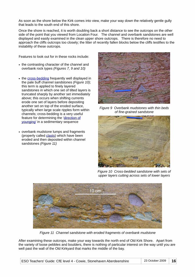
Features to look out for in these rocks include:
• the contrasting character of the channel and overbank rock types (Figures 7, 9 and 10)
• the cross-bedding frequently well displayed in the pale buff channel sandstones (Figure 10); this term is applied to finely layered sandstones in which one set of tilted layers is truncated sharply by another set immediately above; this occurs when shifting currents erode one set of layers before depositing another set on top of the eroded surface, typically when large scale ripples form within channels; cross-bedding is a very useful feature for determining the ‘direction of younging’ in a sedimentary sequence
• overbank mudstone lumps and fragments (properly called clasts) which have been eroded and then deposited within channel sandstones (Figure 11)
Figure 9 Overbank mudstones with thin bedsof fine-grained sandstone
Figure 10 Cross-bedded sandstone with sets of upper layers cutting across sets of lower layers
Figure 11 Channel sandstone with eroded fragments of overbank mudstone
After examining these outcrops, make your way towards the north end of Old Kirk Shore. Apart from the variety of loose pebbles and boulders, there is nothing of particular interest on the way until you are well past the wall of the Old Kirkyard that marks the middle of the bay.
Location Six: Old Kirk Shore - North EndEven from a distance, the rocks in the cliffs that rise up at the north end of Old Kirk Shore look different from those seen so far. Although most of the cliff outcrops have the same weathered purple-stained appearance, two very different rock units are represented. One is the very bottom layer (called the Basal Breccia) of the astonishingly thick sequence of sedimentary strata that stretches southwards from here to beyond the Firth of Tay. The other is a much altered fragment of ancient oceanic rocks that got caught up in the collision between the three continents that came together between 500 and 420 million years ago when the geological foundation of much of Britain was formed. This older unit belongs to the Highland Border Complex (HBC). The three continents have been named Laurentia (modern N America with North Britain attached), Avalonia (South Britain with various other parts of modern Europe and Newfoundland), and Baltica (modern Scandinavia and adjacent territories).
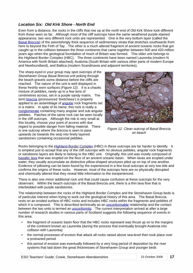
The sharp-eyed in your group may spot outcrops of the Stonehaven Group Basal Breccia unit poking through the beach gravels some distance before the cliffs are reached. The nature of the unit is well displayed in these freshly worn surfaces (Figure 12). It is a chaotic mixture of pebbles, rarely up to a few tens of centimetres across, set in a purple sandy matrix. The term breccia (pronounced ‘bretcheea’) is properly applied to an assemblage of angular rock fragments set in a matrix. In spite of its name, this rock is really a conglomerate containing many angular and sub angular pebbles. Patches of the same rock can be seen locally in the cliff outcrops. Although the risk is very small at this locality, choose your point of access with due regard to possible danger from falling material. There is one outcrop where the breccia is seen to pass upwards (ie towards the sea) into finely layered sandstones containing occasional pebbles.
Figure 12 Clean outcrop of Basal Brecciaon beach
Rocks belonging to the Highland Border Complex (HBC) in these outcrops are far harder to identify. It is simplest just to accept that any of the cliff outcrops with no obvious pebbles, angular rock fragments or sandstone layers are likely to belong to the HBC unit. Originally, this unit was mostly composed of basaltic lava that was erupted on the floor of an ancient oceanic basin. When lavas are erupted under water, they usually accumulate as distinctive pillow-shaped structures piled up on top of one another. Evidence of pillowing can be been found by the experienced in a few local outcrops at very low tide and confirms the origins of these rocks. However, most of the outcrops here are so physically disrupted and chemically altered that they reveal little information to the inexperienced.
There is also one minor additional rock unit that could cause confusion at these outcrops for the very observant. Within the beach outcrops of the Basal Breccia unit, there is a thin lava flow that is interbedded with purple sandstones.
The relationship between the rocks of the Highland Border Complex and the Stonehaven Group beds is of particular interest when trying to work out the geological history of this area. The Basal Breccia rests on an eroded surface of HBC rocks and includes HBC rocks within the fragments and pebbles of which it is composed. This is described technically as an unconformable relationship and the contact between the two units is termed an unconformity. The current interpretation arrived at after a large number of research studies in various parts of Scotland suggests the following sequence of events in this area:
• the fragment of oceanic basin floor that the HBC rocks represent was thrust up on to the margins of the continent known as Laurentia (during the process that eventually brought Avalonia into collision with Laurentia)
• the normal processes of erosion that attack all rocks raised above sea-level then took place over a protracted period
• this period of erosion was eventually followed by a very long period of deposition by the river systems that laid down the great thicknesses of Stonehaven Group and younger beds
ESO Teachers' Guide: Cowie, Stonehaven Aberdeenshire 23 October 2009 17
• the first Stonehaven Group layers to be deposited were laid down as angular conglomerates on top of the eroded surface of HBC rocks; from the limited thickness and the relatively small fragment sizes of these deposits, this surface appears to have been characterised by low relief and gentle slopes
• the thin lava flow within the sandstones that follow indicates that volcanoes were active in the area right from the beginning of this much younger phase of sediment deposition
• subsequent plate movements compressed the local rock sequences resulting in the near vertical attitude of both the bedding and the unconformity
The story that emerges from these rather difficult outcrops is thus a hugely important one for understanding this period of Scottish geology. As you stand facing the outcrops in the cliffs at the north end of Old Kirk Shore, you are, in effect, looking through near-vertical layers of river-deposited ancient sandstones and conglomerates to an even more ancient land surface made up of oceanic rocks thrust into place during the early death throes of the now-vanished Iapetus Ocean. Wow!!
You have two choices for regaining the cliff-top path that leads to Location Seven at the Old Kirk. You can retrace your steps to the south end of Old Kirk Shore and ascend the same gully that you descended to reach Location Five. Alternatively, it may be possible, depending on the vegetation conditions and the sure-footedness of your party, to shorten the route by clambering up the vague path that heads directly up the slope towards the middle of the curving wall surrounding the kirkyard.
Location Seven: Old Cowie KirkyardAfter the geologically challenging rocks of the Old Kirk Shore, this kirkyard can provide some interesting and diverting examples of how people have made use of various types of rock for different purposes. The long history of the site is also well explained in a display panel located near the main entrance at the far left corner of the kirkyard (as viewed with your back to the sea).
Graveyards in general can lend themselves to many different kinds of study and survey. Cowie Kirkyard is particularly rich in such possibilities and is also a beautiful and special place in its own right. Here are some suggestions for activities, all of which can be modified to suit different ages of group members:
• observe, describe and record the nature of the various types of stone used to build the ruined chapel, suggesting reasons for the many variations observed (windows and doorway use various sandstones, some pebbly and obviously local - sandstone is easier to carve and shape than other local rocks; walls incorporate all sorts of local stone, some as rough boulders, others clearly selected because of their natural flat surfaces; blocks of a hard almost slaty metamorphic rock with parallel ‘layering’ [actually cleavage] are especially common, while less regular lumps of granite and sandstone also stand out)
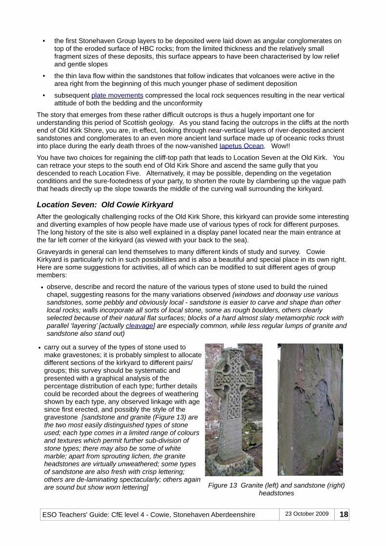
• carry out a survey of the types of stone used to make gravestones; it is probably simplest to allocate different sections of the kirkyard to different pairs/groups; this survey should be systematic and presented with a graphical analysis of the percentage distribution of each type; further details could be recorded about the degrees of weathering shown by each type, any observed linkage with age since first erected, and possibly the style of the gravestone [sandstone and granite (Figure 13) are the two most easily distinguished types of stone used; each type comes in a limited range of colours and textures which permit further sub-division of stone types; there may also be some of white marble; apart from sprouting lichen, the granite headstones are virtually unweathered; some types of sandstone are also fresh with crisp lettering; others are de-laminating spectacularly; others again are sound but show worn lettering]
• other possible information that can be obtained by examining the gravestones include life expectancy, style of headstone, designs of engraved symbols (Figure14), types of employment represented, and the order in which different parts of the graveyard were filled up; the rate of growth and distribution of different types of lichen also makes an interesting study in its own right
Figure 14 Decorated sandstone headstone
Location Eight: Ruthery HeadLeave the kirkyard by the gate at its east-most end and continue along the cliff top route for a further 240 metres. There is no longer any made path and your group will need to make its way along the edge of the golf course. This obviously raises safety issues since golfers may be teeing off in your direction from behind. However, with good timing and a bit of courtesy on both sides, there should not be any real problem. Your destination lies just past the green on your left on the grassy headland immediately beyond the second tee. This viewpoint lies immediately above Ruthery Head.
This location is an important one since it reveals the final geological ‘treasure’ of this area. Standing above Ruthery Head, there is a clear view over Craigeven Bay to the north and east. The headland itself rises above outcrops of the same altered HBC ocean floor rocks encountered at beach level at Location Seven. A short distance to the north of the headland, the Highland Boundary Fault slices through the rock outcrops and brings the HBC rocks into direct contact with Dalradian metamorphic rocks. Outcrops of Dalradian schists and gneisses are found along the coast northwards all the way to Fraserburgh and beyond. They mark the NE extremity of a major group of rocks that forms a broad strip across Scotland that extends south-westwards from the Grampian area all the way to Argyll.
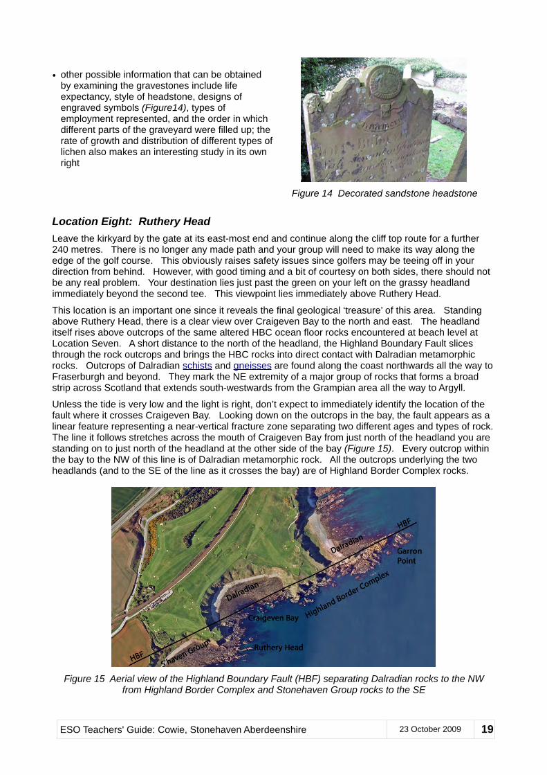
Unless the tide is very low and the light is right, don’t expect to immediately identify the location of the fault where it crosses Craigeven Bay. Looking down on the outcrops in the bay, the fault appears as a linear feature representing a near-vertical fracture zone separating two different ages and types of rock. The line it follows stretches across the mouth of Craigeven Bay from just north of the headland you are standing on to just north of the headland at the other side of the bay (Figure 15). Every outcrop within the bay to the NW of this line is of Dalradian metamorphic rock. All the outcrops underlying the two headlands (and to the SE of the line as it crosses the bay) are of Highland Border Complex rocks.
Figure 15 Aerial view of the Highland Boundary Fault (HBF) separating Dalradian rocks to the NW from Highland Border Complex and Stonehaven Group rocks to the SE
ESO Teachers' Guide: Cowie, Stonehaven Aberdeenshire 23 October 2009 19
If you turn around and look back at the kirkyard, you will be surprised to discover that the line of the fault actually runs between the kirkyard wall and the shore immediately below it. There are no outcrops to be seen on this slope, however. You will also appreciate now that the HBC rocks examined at Location Six form part of a very narrow slice of rock sandwiched vertically between the Basal Breccia of the Stonehaven Group and the Highland Boundary Fault. This is typical of the several very narrow outcrops of the Highland Border Complex which are only found in Scotland along the line of the Highland Boundary Fault. The limited exposure and highly altered condition of these rocks makes them difficult to study and interpret. Their real provenance as altered ocean floor rocks has only been confidently explained within the last few decades.
From this viewpoint on Ruthery Head, you can see the rest of the recommended excursion route. It drops down to the shore again just beyond the current location, follows the shore round the bay to the far headland, and then climbs back up to the cliff-top and out to Garron Point, the farthest visible part of the coastline. The need to repeatedly drop down from and climb back up to the cliff-top path is an unfortunate but necessary feature of this excursion because of sections of the coast that are either virtually impassable or require walking over very awkward and slippery surfaces.
Location Nine: Craigeven Bay - South EndProvided there are no players on the green or tee, take the short path that passes between them and find the top of the old grassy track that descends the gully immediately beyond the west end of the tee. This is the only practical route down to the shore. Unfortunately, the track soon deteriorates where sections have been destroyed by minor landslips. Particular care is needed when traversing the muddy middle and bottom parts of the gully.
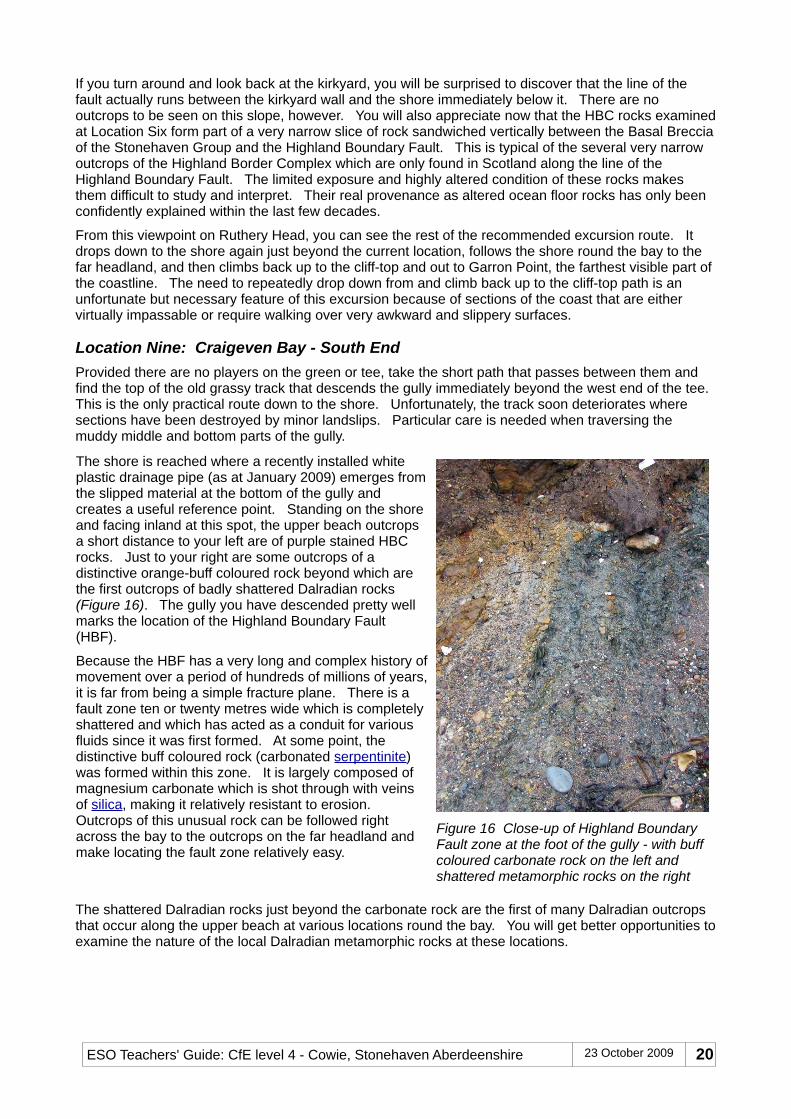
The shore is reached where a recently installed white plastic drainage pipe (as at January 2009) emerges from the slipped material at the bottom of the gully and creates a useful reference point. Standing on the shore and facing inland at this spot, the upper beach outcrops a short distance to your left are of purple stained HBC rocks. Just to your right are some outcrops of a distinctive orange-buff coloured rock beyond which are the first outcrops of badly shattered Dalradian rocks (Figure 16). The gully you have descended pretty well marks the location of the Highland Boundary Fault (HBF).
Because the HBF has a very long and complex history of movement over a period of hundreds of millions of years, it is far from being a simple fracture plane. There is a fault zone ten or twenty metres wide which is completely shattered and which has acted as a conduit for various fluids since it was first formed. At some point, the distinctive buff coloured rock (carbonated serpentinite)was formed within this zone. It is largely composed of magnesium carbonate which is shot through with veins of silica, making it relatively resistant to erosion. Outcrops of this unusual rock can be followed right across the bay to the outcrops on the far headland and make locating the fault zone relatively easy.
Figure 16 Close-up of Highland Boundary Fault zone at the foot of the gully - with buff coloured carbonate rock on the left and shattered metamorphic rocks on the right
The shattered Dalradian rocks just beyond the carbonate rock are the first of many Dalradian outcrops that occur along the upper beach at various locations round the bay. You will get better opportunities to examine the nature of the local Dalradian metamorphic rocks at these locations.
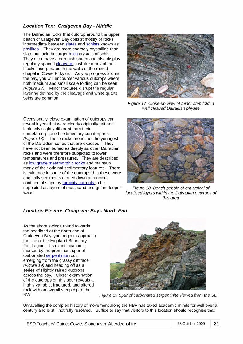
Location Ten: Craigeven Bay - MiddleThe Dalradian rocks that outcrop around the upper beach of Craigeven Bay consist mostly of rocks intermediate between slates and schists known as phyllites. They are more coarsely crystalline than slate but lack the larger mica crystals of schist. They often have a greenish sheen and also display regularly spaced cleavage, just like many of the blocks incorporated in the walls of the ruined chapel in Cowie Kirkyard. As you progress around the bay, you will encounter various outcrops where both medium and small scale folding can be seen (FIgure 17). Minor fractures disrupt the regular layering defined by the cleavage and white quartz veins are common.
Figure 17 Close-up view of minor step fold in well cleaved Dalradian phyllite
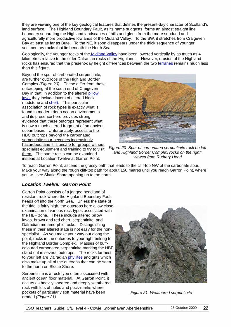
Occasionally, close examination of outcrops can reveal layers that were clearly originally grit and look only slightly different from their unmetamorphosed sedimentary counterparts (Figure 18). These rocks are in fact the youngest of the Dalradian series that are exposed. They have not been buried as deeply as other Dalradian rocks and were therefore subjected to lower temperatures and pressures. They are described as low grade metamorphic rocks and maintain many of their original sedimentary features. There is evidence in some of the outcrops that these were originally sediments carried down an ancient continental slope by turbidity currents to be deposited as layers of mud, sand and grit in deeper water
Figure 18 Beach pebble of grit typical of localised layers within the Dalradian outcrops of
this area
Location Eleven: Craigeven Bay - North End
As the shore swings round towards the headland at the north end of Craigeven Bay, you begin to approach the line of the Highland Boundary Fault again. Its exact location is marked by the prominent spur of carbonated serpentinite rock emerging from the grassy cliff face (Figure 19) and heading off as a series of slightly raised outcrops across the bay. Closer examination of the outcrops on this spur reveals a highly variable, fractured, and altered rock with an overall steep dip to the NW. Figure 19 Spur of carbonated serpentinite viewed from the SE
Unravelling the complex history of movement along the HBF has taxed academic minds for well over a century and is still not fully resolved. Suffice to say that visitors to this location should recognise that
ESO Teachers' Guide: Cowie, Stonehaven Aberdeenshire 23 October 2009 21
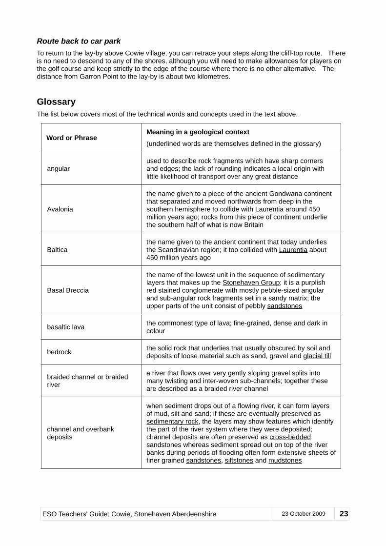
they are viewing one of the key geological features that defines the present-day character of Scotland’s land surface. The Highland Boundary Fault, as its name suggests, forms an almost straight line boundary separating the Highland landscapes of hills and glens from the more subdued and agriculturally more productive lowlands of the Midland Valley. To the SW, it stretches from Craigeven Bay at least as far as Bute. To the NE, it soon disappears under the thick sequence of younger sedimentary rocks that lie beneath the North Sea.Geologically, the younger rocks of the Midland Valley have been lowered vertically by as much as 4 kilometres relative to the older Dalradian rocks of the Highlands. However, erosion of the Highland rocks has ensured that the present-day height differences between the two terranes remains much less than this figure.Beyond the spur of carbonated serpentinite, are further outcrops of the Highland Border Complex (Figure 20). These differ from those outcropping at the south end of Craigeven Bay in that, in addition to the altered pillow lava, they include layers of altered black mudstone and chert. This particular association of rock types is exactly what is found in modern deep ocean environments and its presence here provides strong evidence that these outcrops represent what is now a much altered fragment of an ancient ocean basin. Unfortunately, access to the HBC outcrops beyond the carbonated serpentinite spur becomes increasingly hazardous, and it is unsafe for groups without specialist equipment and training to try to visit them. The same rocks can be examined instead at Location Twelve at Garron Point.
Figure 20 Spur of carbonated serpentinite rock on left and Highland Border Complex rocks on the right;
viewed from Ruthery Head
To reach Garron Point, ascend the grassy path that leads to the cliff-top NW of the carbonate spur. Make your way along the rough cliff-top path for about 150 metres until you reach Garron Point, where you will see Skatie Shore opening up to the north.
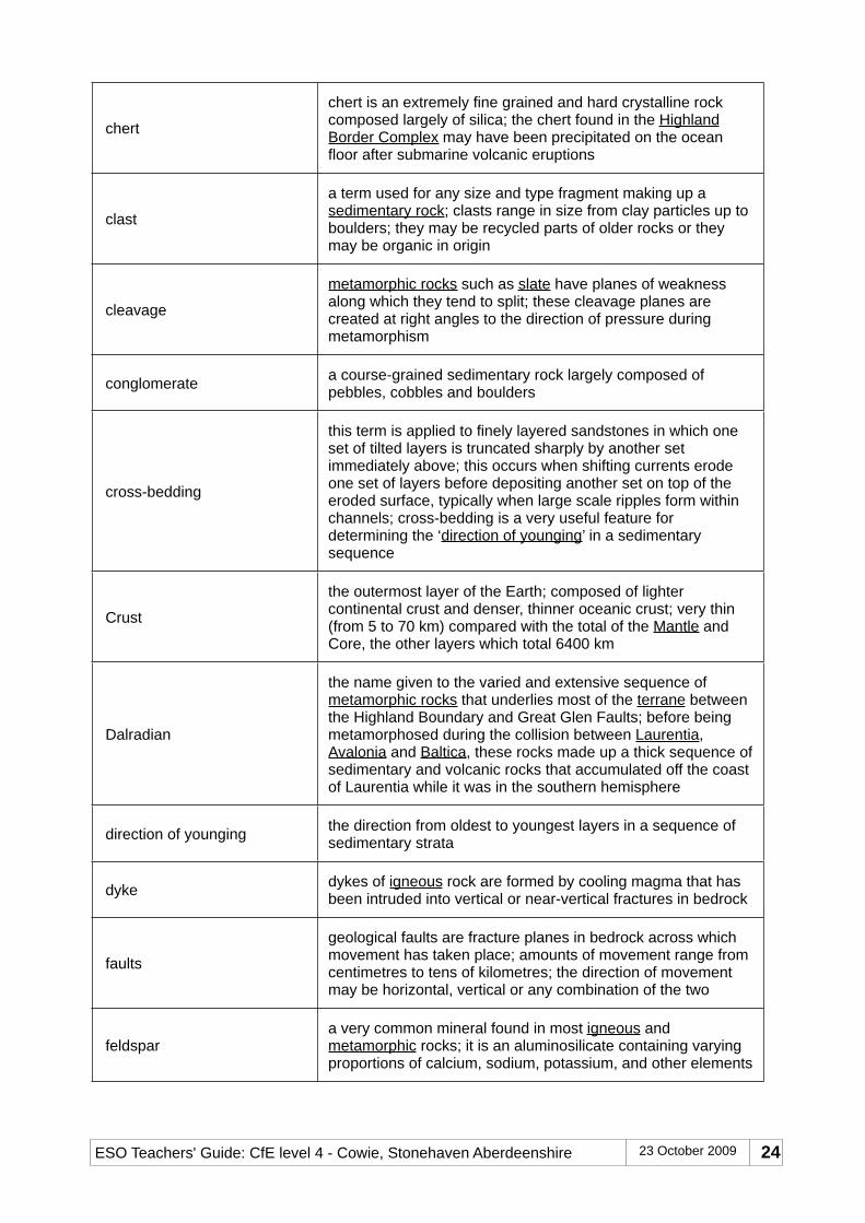
Location Twelve: Garron PointGarron Point consists of a jagged headland of resistant rock where the Highland Boundary Fault heads off into the North Sea. Unless the state of the tide is fairly high, the outcrops here allow close examination of various rock types associated with the HBF zone. These include altered pillow lavas, brown and red chert, serpentinite, and Dalradian metamorphic rocks. Distinguishing these in their altered state is not easy for the non-specialist. As you make your way out along the point, rocks in the outcrops to your right belong to the Highland Border Complex. Masses of buff-coloured carbonated serpentinite marking the HBF stand out in several outcrops. The rocks farthest to your left are Dalradian phyllites and grits which also make up all of the outcrops that can be seen to the north on Skatie Shore.
Serpentinite is a rock type often associated with ancient ocean floor material. At Garron Point, it occurs as heavily sheared and deeply weathered rock with lots of holes and pock-marks where pockets of particularly soft material have been eroded (Figure 21)
Route back to car parkTo return to the lay-by above Cowie village, you can retrace your steps along the cliff-top route. There is no need to descend to any of the shores, although you will need to make allowances for players on the golf course and keep strictly to the edge of the course where there is no other alternative. The distance from Garron Point to the lay-by is about two kilometres.
GlossaryThe list below covers most of the technical words and concepts used in the text above.
Word or PhraseMeaning in a geological context(underlined words are themselves defined in the glossary)
angularused to describe rock fragments which have sharp corners and edges; the lack of rounding indicates a local origin with little likelihood of transport over any great distance
Avalonia
the name given to a piece of the ancient Gondwana continent that separated and moved northwards from deep in the southern hemisphere to collide with Laurentia around 450 million years ago; rocks from this piece of continent underlie the southern half of what is now Britain
Balticathe name given to the ancient continent that today underlies the Scandinavian region; it too collided with Laurentia about 450 million years ago
Basal Breccia
the name of the lowest unit in the sequence of sedimentary layers that makes up the Stonehaven Group; it is a purplish red stained conglomerate with mostly pebble-sized angular and sub-angular rock fragments set in a sandy matrix; the upper parts of the unit consist of pebbly sandstones
basaltic lava the commonest type of lava; fine-grained, dense and dark in colour
bedrock the solid rock that underlies that usually obscured by soil and deposits of loose material such as sand, gravel and glacial till
braided channel or braided river
a river that flows over very gently sloping gravel splits into many twisting and inter-woven sub-channels; together these are described as a braided river channel
channel and overbank deposits
when sediment drops out of a flowing river, it can form layers of mud, silt and sand; if these are eventually preserved as sedimentary rock, the layers may show features which identify the part of the river system where they were deposited; channel deposits are often preserved as cross-bedded sandstones whereas sediment spread out on top of the river banks during periods of flooding often form extensive sheets of finer grained sandstones, siltstones and mudstones
ESO Teachers' Guide: Cowie, Stonehaven Aberdeenshire 23 October 2009 23
chert
chert is an extremely fine grained and hard crystalline rock composed largely of silica; the chert found in the Highland Border Complex may have been precipitated on the ocean floor after submarine volcanic eruptions
clast
a term used for any size and type fragment making up a sedimentary rock; clasts range in size from clay particles up to boulders; they may be recycled parts of older rocks or they may be organic in origin
cleavage
metamorphic rocks such as slate have planes of weakness along which they tend to split; these cleavage planes are created at right angles to the direction of pressure during metamorphism
conglomerate a course-grained sedimentary rock largely composed of pebbles, cobbles and boulders
cross-bedding
this term is applied to finely layered sandstones in which one set of tilted layers is truncated sharply by another set immediately above; this occurs when shifting currents erode one set of layers before depositing another set on top of the eroded surface, typically when large scale ripples form within channels; cross-bedding is a very useful feature for determining the ‘direction of younging’ in a sedimentary sequence
Crust
the outermost layer of the Earth; composed of lighter continental crust and denser, thinner oceanic crust; very thin (from 5 to 70 km) compared with the total of the Mantle and Core, the other layers which total 6400 km
Dalradian
the name given to the varied and extensive sequence of metamorphic rocks that underlies most of the terrane between the Highland Boundary and Great Glen Faults; before being metamorphosed during the collision between Laurentia, Avalonia and Baltica, these rocks made up a thick sequence of sedimentary and volcanic rocks that accumulated off the coast of Laurentia while it was in the southern hemisphere
direction of younging the direction from oldest to youngest layers in a sequence of sedimentary strata
dyke dykes of igneous rock are formed by cooling magma that has been intruded into vertical or near-vertical fractures in bedrock
faults
geological faults are fracture planes in bedrock across which movement has taken place; amounts of movement range from centimetres to tens of kilometres; the direction of movement may be horizontal, vertical or any combination of the two
feldspara very common mineral found in most igneous and metamorphic rocks; it is an aluminosilicate containing varying proportions of calcium, sodium, potassium, and other elements
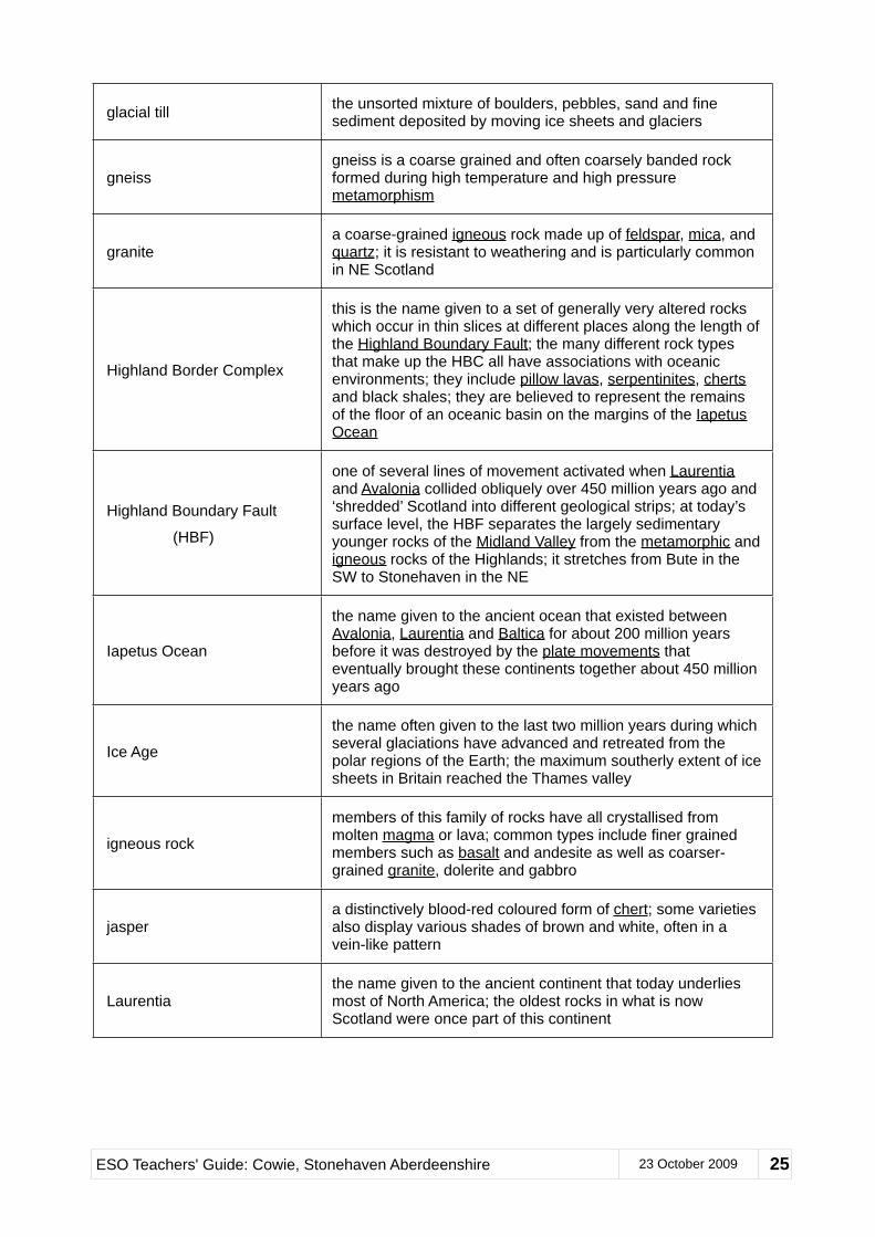
glacial till the unsorted mixture of boulders, pebbles, sand and fine sediment deposited by moving ice sheets and glaciers
gneissgneiss is a coarse grained and often coarsely banded rock formed during high temperature and high pressure metamorphism
granitea coarse-grained igneous rock made up of feldspar, mica, and quartz; it is resistant to weathering and is particularly common in NE Scotland
Highland Border Complex
this is the name given to a set of generally very altered rocks which occur in thin slices at different places along the length of the Highland Boundary Fault; the many different rock types that make up the HBC all have associations with oceanic environments; they include pillow lavas, serpentinites, cherts and black shales; they are believed to represent the remains of the floor of an oceanic basin on the margins of the Iapetus Ocean
Highland Boundary Fault
(HBF)
one of several lines of movement activated when Laurentia and Avalonia collided obliquely over 450 million years ago and ‘shredded’ Scotland into different geological strips; at today’s surface level, the HBF separates the largely sedimentary younger rocks of the Midland Valley from the metamorphic and igneous rocks of the Highlands; it stretches from Bute in the SW to Stonehaven in the NE
Iapetus Ocean
the name given to the ancient ocean that existed between Avalonia, Laurentia and Baltica for about 200 million years before it was destroyed by the plate movements that eventually brought these continents together about 450 million years ago
Ice Age
the name often given to the last two million years during which several glaciations have advanced and retreated from the polar regions of the Earth; the maximum southerly extent of ice sheets in Britain reached the Thames valley
igneous rock
members of this family of rocks have all crystallised from molten magma or lava; common types include finer grained members such as basalt and andesite as well as coarser-grained granite, dolerite and gabbro
jaspera distinctively blood-red coloured form of chert; some varieties also display various shades of brown and white, often in a vein-like pattern
Laurentiathe name given to the ancient continent that today underlies most of North America; the oldest rocks in what is now Scotland were once part of this continent
ESO Teachers' Guide: Cowie, Stonehaven Aberdeenshire 23 October 2009 25
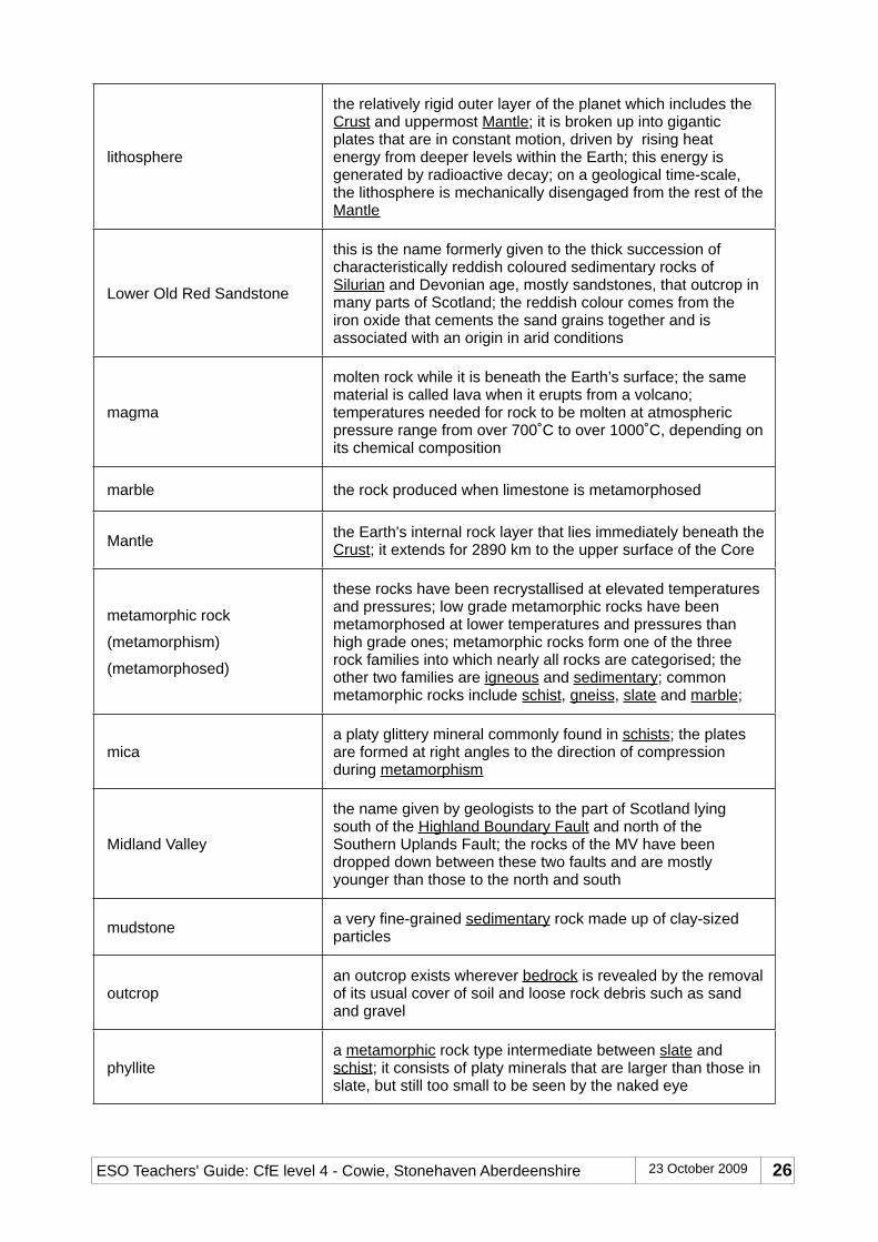
lithosphere
the relatively rigid outer layer of the planet which includes the Crust and uppermost Mantle; it is broken up into gigantic plates that are in constant motion, driven by rising heat energy from deeper levels within the Earth; this energy is generated by radioactive decay; on a geological time-scale, the lithosphere is mechanically disengaged from the rest of the Mantle
Lower Old Red Sandstone
this is the name formerly given to the thick succession of characteristically reddish coloured sedimentary rocks of Silurian and Devonian age, mostly sandstones, that outcrop in many parts of Scotland; the reddish colour comes from the iron oxide that cements the sand grains together and is associated with an origin in arid conditions
magma
molten rock while it is beneath the Earth’s surface; the same material is called lava when it erupts from a volcano; temperatures needed for rock to be molten at atmospheric pressure range from over 700˚C to over 1000˚C, depending on its chemical composition
marble the rock produced when limestone is metamorphosed
Mantle the Earth's internal rock layer that lies immediately beneath the Crust; it extends for 2890 km to the upper surface of the Core
metamorphic rock
(metamorphism)
(metamorphosed)
these rocks have been recrystallised at elevated temperatures and pressures; low grade metamorphic rocks have been metamorphosed at lower temperatures and pressures than high grade ones; metamorphic rocks form one of the three rock families into which nearly all rocks are categorised; the other two families are igneous and sedimentary; common metamorphic rocks include schist, gneiss, slate and marble;
micaa platy glittery mineral commonly found in schists; the plates are formed at right angles to the direction of compression during metamorphism
Midland Valley
the name given by geologists to the part of Scotland lying south of the Highland Boundary Fault and north of the Southern Uplands Fault; the rocks of the MV have been dropped down between these two faults and are mostly younger than those to the north and south
mudstone a very fine-grained sedimentary rock made up of clay-sized particles
outcropan outcrop exists wherever bedrock is revealed by the removal of its usual cover of soil and loose rock debris such as sand and gravel
phyllitea metamorphic rock type intermediate between slate and schist; it consists of platy minerals that are larger than those in slate, but still too small to be seen by the naked eye
when lava is erupted underwater, it tends to form large discrete globules; these flatten out into pillow-shaped lumps as they pile up on top of one another; lava flows made up of these lumps are described as pillow lavas and are a sure indicator of underwater eruption
plate movements
the rock materials that form the surface layers of the Earth are broken up into what are known as tectonic plates; these plates move slowly in human terms but their movements are responsible for nearly all major geological features – and many smaller ones
Pre-Cambrian
this is the all-inclusive name given to the long period of geological time (or era) before life forms with hard parts started appearing in the fossil record at the beginning of the Cambrian period; the Earth was formed 4567 million years ago and the Cambrian period lasted from 542 until 490 million years ago
quartz
one of the commonest minerals and very resistant to weathering; a form of crystalline silicon dioxide; commonly the main constituent of sandstone since quartz is the most durable mineral that remains when pre-existing rocks are weathered and eroded; quartzite is the name given to metamorphosed quartz-rich sandstone
quartz porphyry
a type of igneous rock with a very fine-grained matrix in which are set crystals up to a centimetre or so in size of quartz and feldspar; this texture arises from a period of slow initial cooling of the magma during which large crystals developed followed by a short-lived period of rapid cooling when the rest of the magma crystallised to form the fine grained matrix
sandstone
an extremely common type of sedimentary rock made of sand-sized grains chemically bonded to one another; iron oxide, carbonate and silica are the most common chemical bonding agents; the resistance of the sandstone to weathering and erosion is closely related to the type of bonding agent with iron oxide being the weakest and silica the strongest
schist
schist is one of the commonest metamorphic rocks in NE Scotland; it is formed in conditions of relatively low to moderately elevated temperatures and pressures; schists are often distinguished by the presence of lots of minerals with platy shaped crystals, particularly mica
sedimentary rocks
these rocks are composed of the recycled remains of earlier rocks and living organisms; they tend to be deposited in layers; common types include mudstone, sandstone, limestone and conglomerate
ESO Teachers' Guide: Cowie, Stonehaven Aberdeenshire 23 October 2009 27
serpentinite
a very distinctive relatively soft rock which commonly displays a range of streaky green, red and white colours; it is formed by low-grade metamorphism of ocean floor and mantle rocks and is commonly associated with the plate tectonic processes that lead to the closure of oceans; in this area, the original minerals of the serpentinite are commonly replaced by carbonate minerals (ie it has been carbonated)
sheet flood deposits
these are sediments laid down when rivers overflow their channels and spread thin layers of sand, silt and mud on to their flood plains; they are commonly fine-grained and coloured red as a result of oxidation that occurs when flood waters subside and the newly deposited sediments dry out
siltstone a sedimentary rock in which most of the grains are intermediate in size between mud and sand
Silurian the name given to the geological period that started 444 million years ago and ended 416 million years ago
slate
a low-grade metamorphic rock formed when mudstone is subjected to relatively small increases in temperature and pressure; its characteristic property is well developed cleavage that allows it to be split into thin strong sheets
Stonehaven Group
the name given to the sequence of sedimentary rocks that extends southwards along the coast from Ruthery Head to just beyond Stonehaven harbour; these rocks can also be traced inland for some distance; they are the basal layers of what was formerly called Lower Old Red Sandstone
strata layers of sedimentary rock
Strathmore Syncline
the term syncline is used to describe a sequence of sedimentary layers that has been folded into a basin shape; if the sequence is eroded, the pattern of outcropping rock has the youngest rocks in the middle, flanked by progressively older layers; the Strathmore Syncline is a major structure whose axis extends south-westwards along most of the length of the Highland Boundary fault (its northern margin); it determines the outcrop pattern of rocks south-eastwards as far as the River Tay
tectonic plates see plate movements
terrane
a piece of continental crust that forms a geologically distinctive area with its own geological history which is different from those of surrounding terranes; Scotland is divided into several terranes by several major NE/SW faults; these include the Southern Uplands, Highland Boundary, Great Glen and Moine Thrust Faults
dense currents of sediment-laden water; these currents are generated by slumping in unstable and unconsolidated accumulations of sediment, usually opposite where rivers dump their loads of sediment on the sea bed; they can travel rapidly down the slope of the continental shelf into deeper water where the sediments are redeposited
unconformity
when one set of sedimentary rock layers is overlain by another whose layers are tilted at a significantly different angle, the junction between the two sets of layers is described as an unconformity; the second set is said to be resting unconformably on the first; this relationship occurs when the first set of layers is subjected to erosion and tilting before the second set is deposited; an unconformity thus represents a gap in the geological record during which an often unknown thickness of sedimentary rocks was removed by erosion
wave-cut platform
this is a flat area of bedrock extending out to sea from the base of a cliff and usually only exposed at low tide; it is produced as the erosive action of the sea undermines the cliff and carries away the collapsed debris; the cliff face gradually retreats and the platform gets correspondingly wider
AcknowledgementsThis guide was written in 2009 as part of the Scottish Earth Science Education Forum's Earth Science Outdoors project. Funding for the project came from Scottish Natural Heritage and a Science Engagement Grant from the Scottish Government. The guide was written by a team of earth scientists and educators, and we are grateful to all the organisations and individuals who have been involved. Photographs are by Peter Craig.
If you have used this guide, we would like to hear from you! We value all comments and suggestions for improvement, and even a quick email to let us know you've used the guide is useful to help demonstrate the interest and demand for guides like this – please contact us through the SESEF website.