39
Earth’s Interior © Copyright 2006. M. J. Krech. All rights reserved.
| Date post: | 16-Dec-2015 |
| Category: |
Documents |
| Upload: | scot-scott |
| View: | 217 times |
| Download: | 2 times |
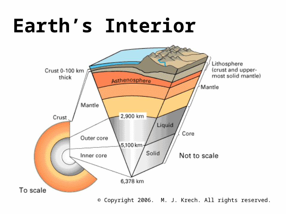
Earth’s Interior
© Copyright 2006. M. J. Krech. All rights reserved.
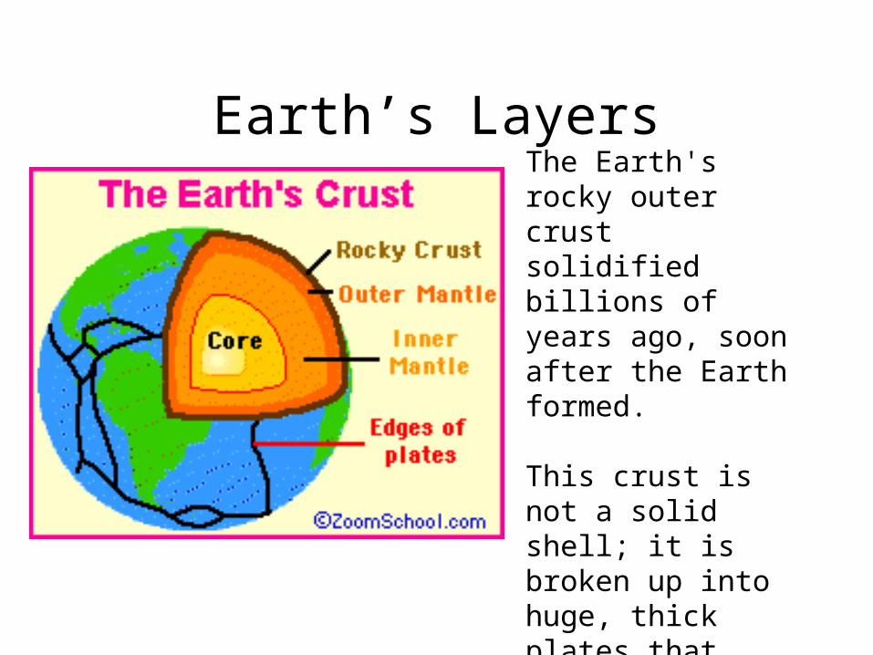
Earth’s LayersThe Earth's rocky outer crust solidified billions of years ago, soon after the Earth formed.
This crust is not a solid shell; it is broken up into huge, thick plates that drift atop the soft, underlying mantle.
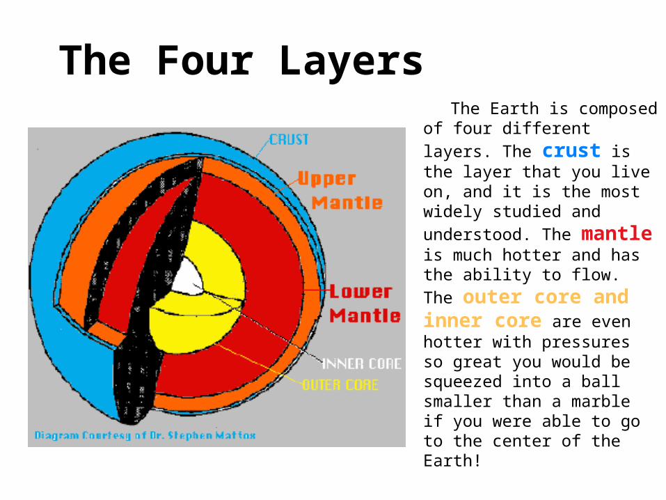
The Four Layers The Earth is composed of four
different layers. The crust is the layer that you live on, and it is the most widely studied
and understood. The mantle is much hotter and has the
ability to flow. The outer core and inner core are even hotter with pressures so great you would be squeezed into a ball smaller than a marble if you were able to go to the center of the Earth!
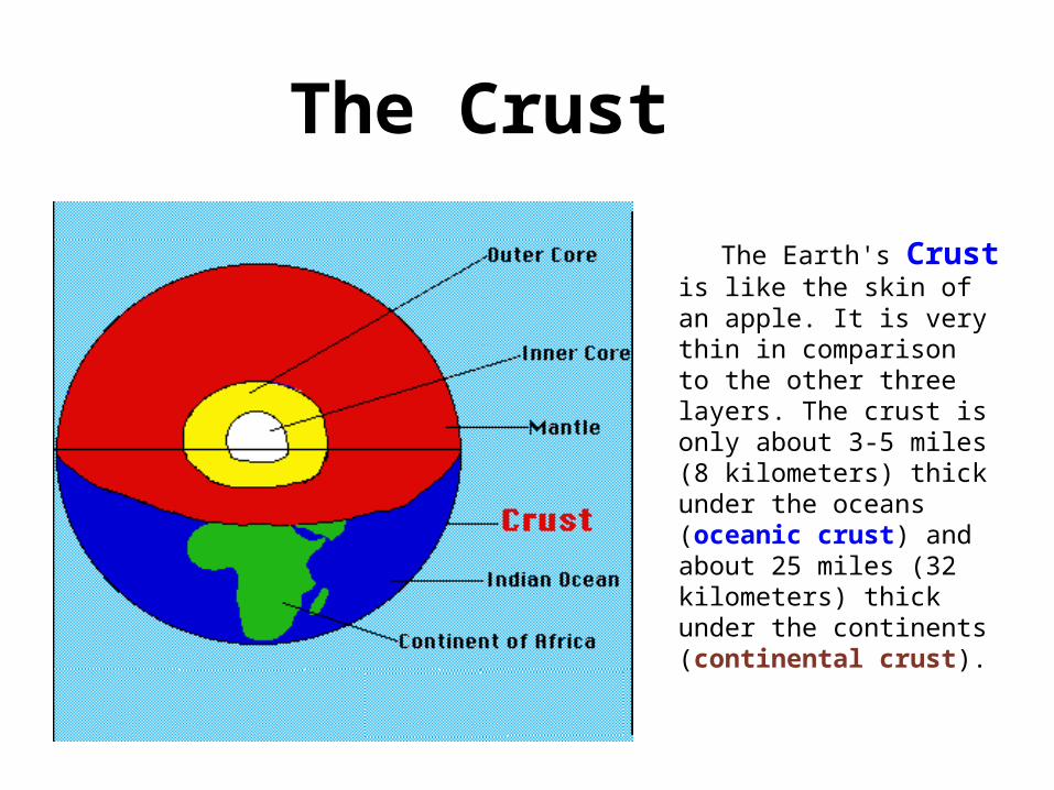
The Crust
The Earth's Crust is like the skin of an apple. It is very thin in comparison to the other three layers. The crust is only about 3-5 miles (8 kilometers) thick under the oceans (oceanic crust) and about 25 miles (32 kilometers) thick under the continents (continental crust).
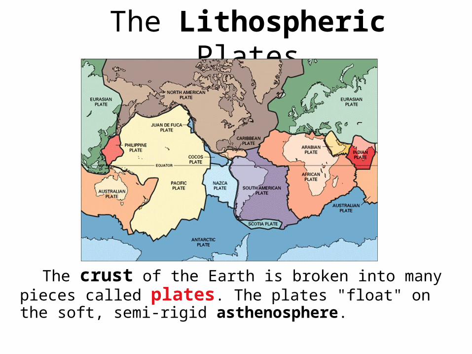
The Lithospheric Plates
The crust of the Earth is broken into many pieces called plates. The plates "float" on the soft, semi-rigid asthenosphere.
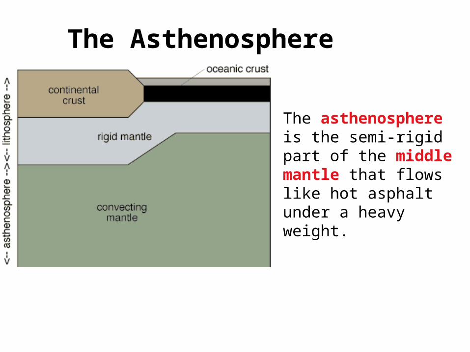
The Asthenosphere
The asthenosphere is the semi-rigid part of the middle mantle that flows like hot asphalt under a heavy weight.
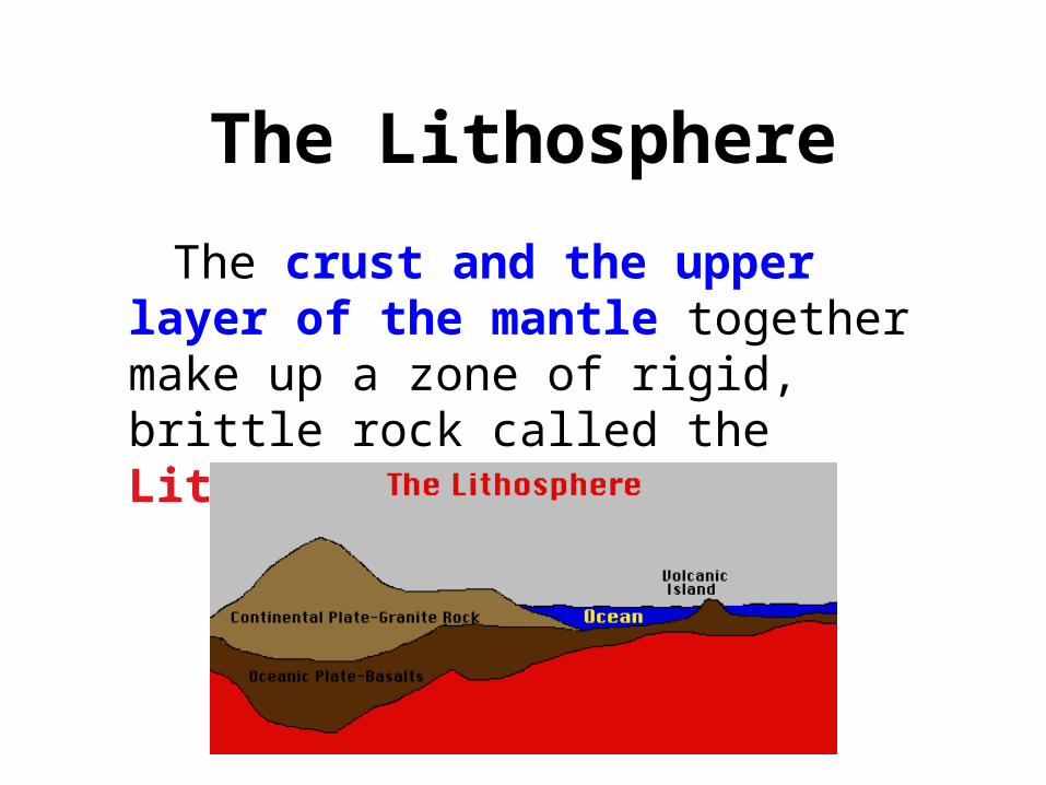
The Lithosphere
The crust and the upper layer of the mantle together make up a zone of rigid, brittle rock called the Lithosphere.
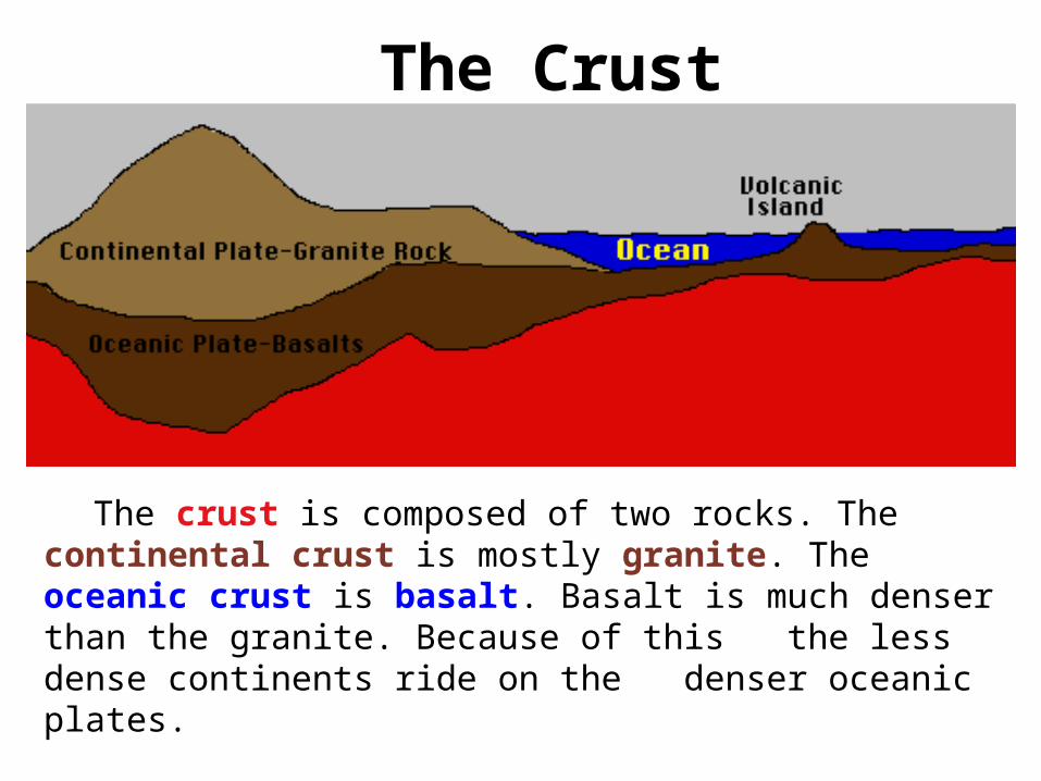
The Crust
The crust is composed of two rocks. The continental crust is mostly granite. The oceanic crust is basalt. Basalt is much denser than the granite. Because of this the less dense continents ride on the denser oceanic plates.
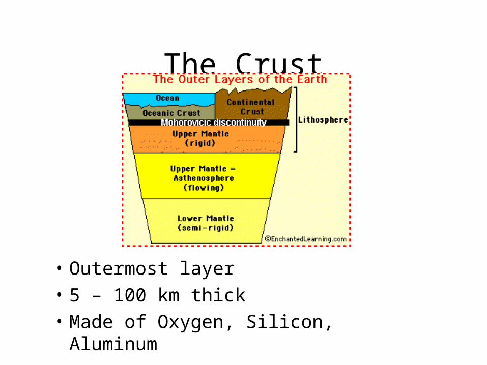
The Crust
• Outermost layer
• 5 – 100 km thick
• Made of Oxygen, Silicon, Aluminum
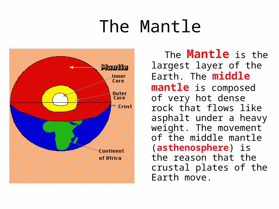
The Mantle
The Mantle is the largest layer of the Earth. The middle mantle is composed of very hot dense rock that flows like asphalt under a heavy weight. The movement of the middle mantle (asthenosphere) is the reason that the crustal plates of the Earth move.
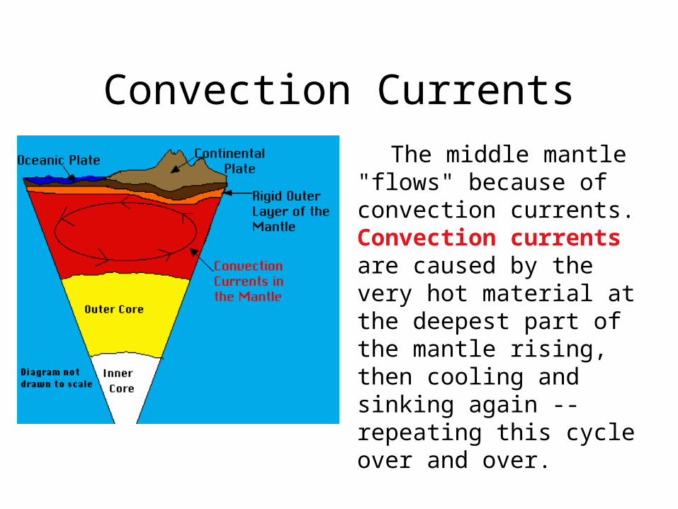
Convection Currents
The middle mantle "flows" because of convection currents. Convection currents are caused by the very hot material at the deepest part of the mantle rising, then cooling and sinking again --repeating this cycle over and over.
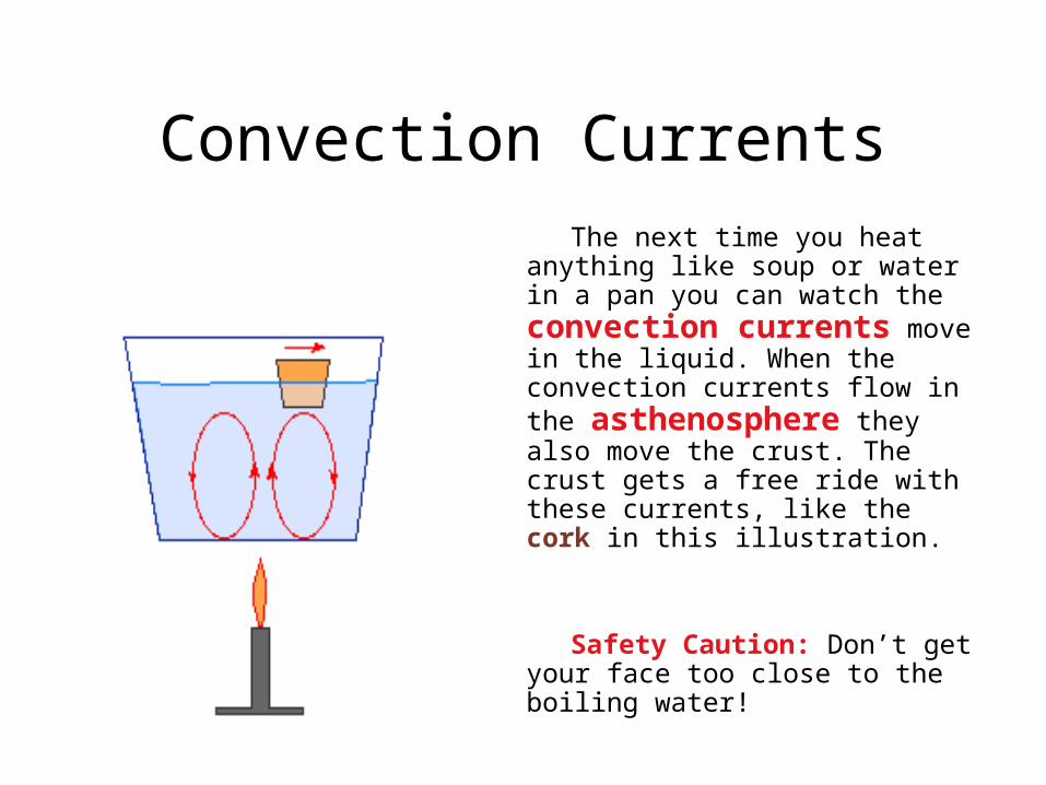
Convection Currents The next time you heat anything like
soup or water in a pan you can watch the convection currents move in the liquid. When the convection currents flow in the asthenosphere they also move the crust. The crust gets a free ride with these currents, like the cork in this illustration.
Safety Caution: Don’t get your face too close to the boiling water!
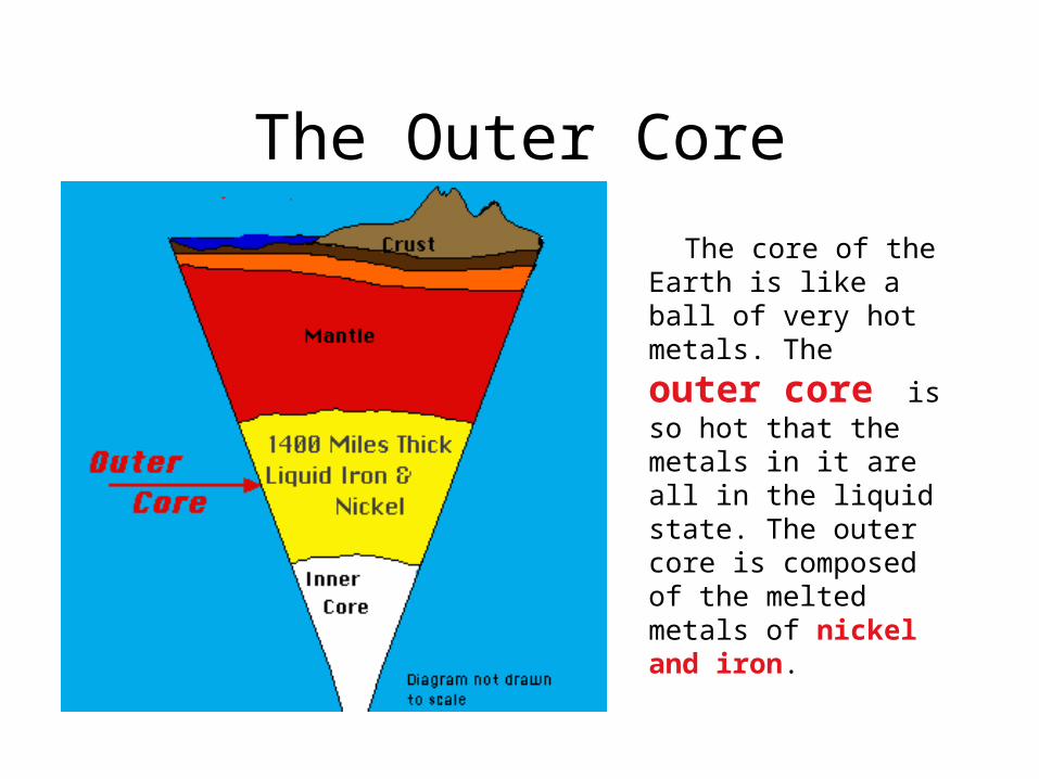
The Outer Core
The core of the Earth is like a ball of very hot metals. The
outer core is so hot that the metals in it are all in the liquid state. The outer core is composed of the melted metals of nickel and iron.
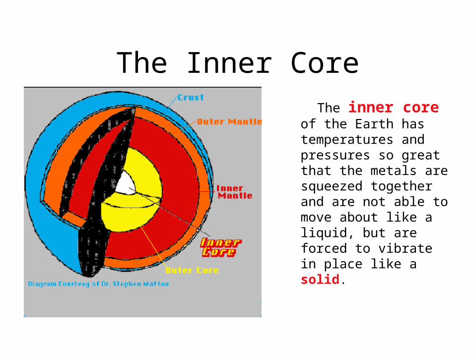
The Inner Core
The inner core of the Earth has temperatures and pressures so great that the metals are squeezed together and are not able to move about like a liquid, but are forced to vibrate in place like a solid.
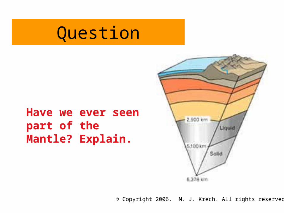
Question
Have we ever seen part of the Mantle? Explain.
© Copyright 2006. M. J. Krech. All rights reserved.

Continental Drift
http://members.enchantedlearning.com/subjects/astronomy/planets/earth/Continents.shtml
Alfred Wegener 1900’sContinents were once a single land mass that drifted apart.
Fossils of the same plants and animals are found on different continents
Called this supercontinent Pangea, Greek for “all Earth”
245 Million years ago
Split again – Laurasia & Gondwana 180 million years ago
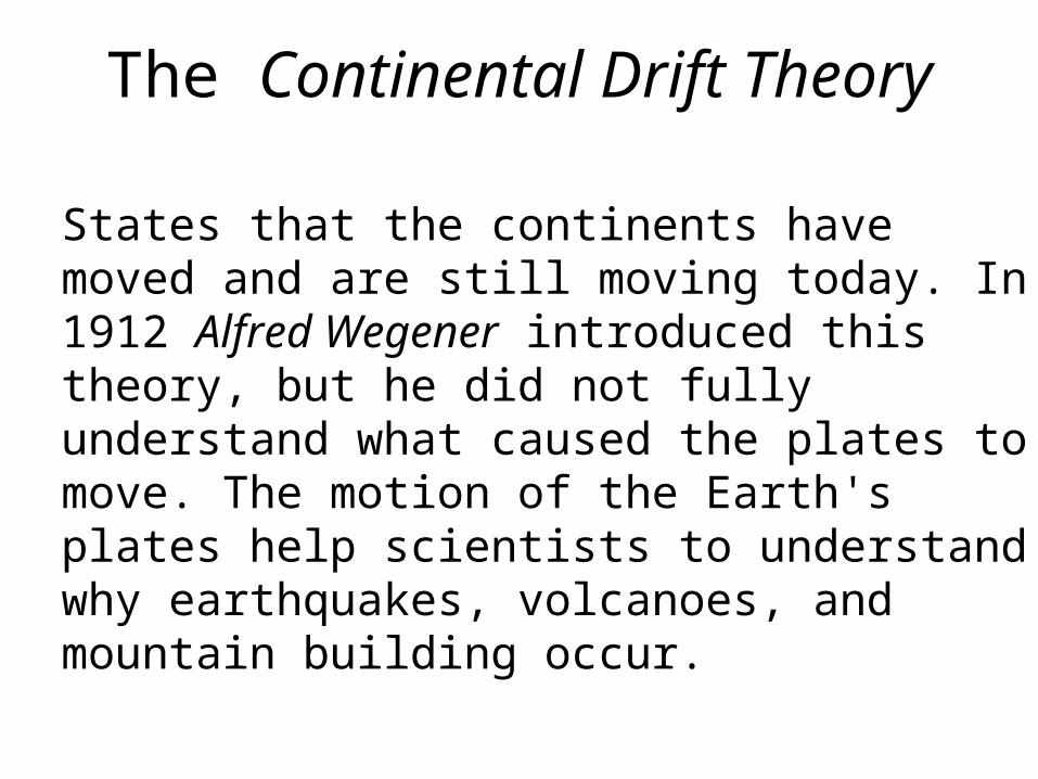
The Continental Drift Theory
States that the continents have moved and are still moving today. In 1912 Alfred Wegener introduced this theory, but he did not fully understand what caused the plates to move. The motion of the Earth's plates help scientists to understand why earthquakes, volcanoes, and mountain building occur.
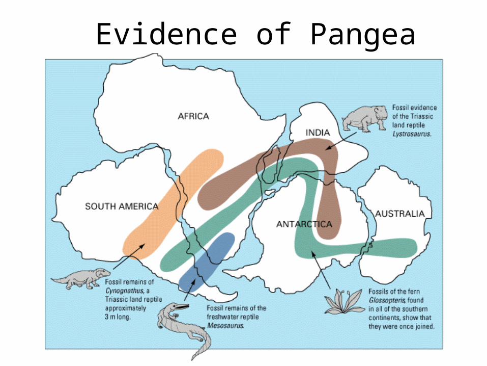
Evidence of Pangea

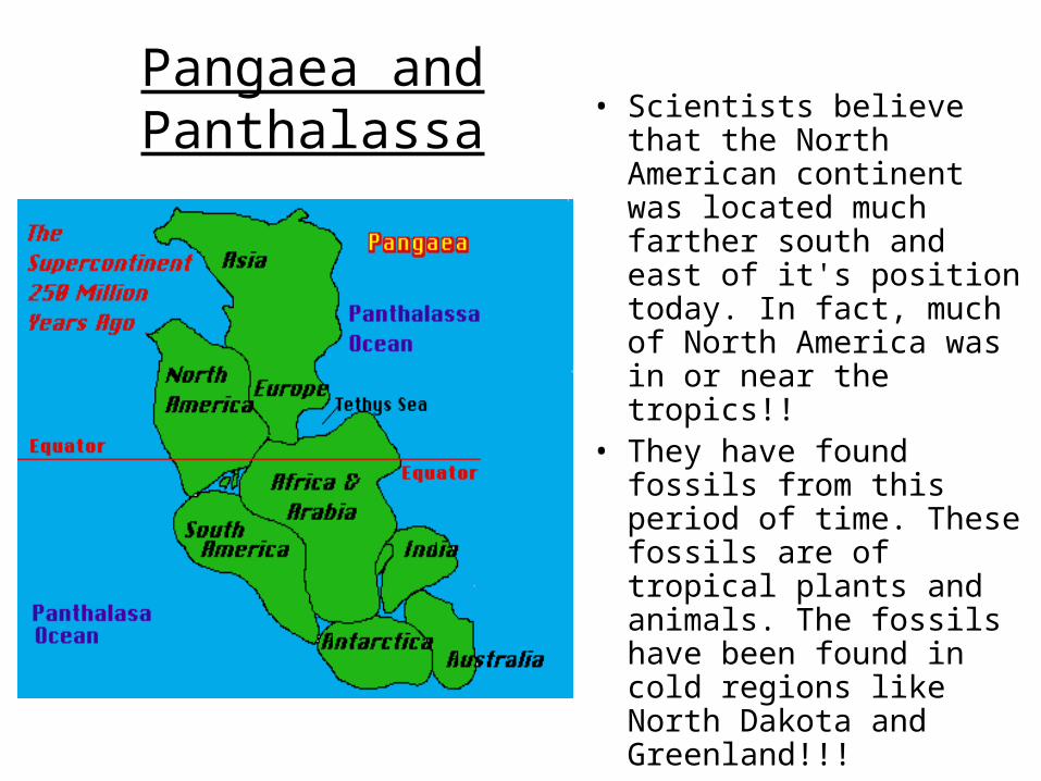
Pangaea and PanthalassaJust before the days of the dinosaurs the Earth's continents were all connected into one huge landmass called Pangaea . This huge super continent was surrounded by one gigantic ocean called Panthalassa.
Notice the position of the continents of Antarctica (Far north of its current position), Australia (flipped sideways and far west of its current position) and the subcontinent of India (Hundreds of miles from Asia).
Pangaea and Panthalassa
• Scientists believe that the North American continent was located much farther south and east of it's position today. In fact, much of North America was in or near the tropics!!
• They have found fossils from this period of time. These fossils are of tropical plants and animals. The fossils have been found in cold regions like North Dakota and Greenland!!!
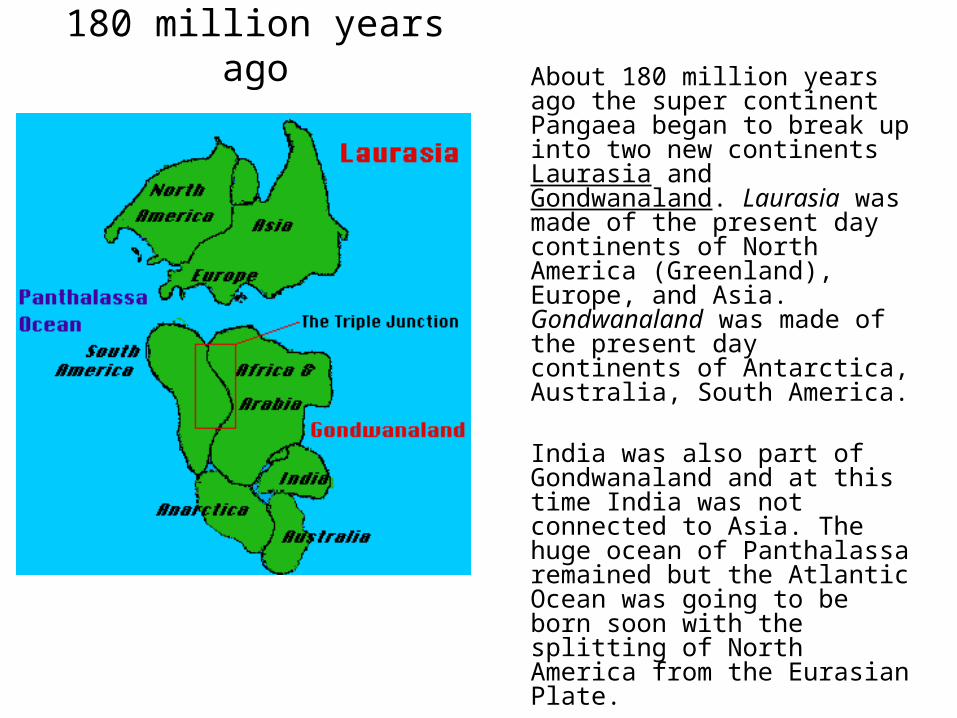
180 million years agoAbout 180 million years ago the super continent Pangaea began to break up into two new continents Laurasia and Gondwanaland. Laurasia was made of the present day continents of North America (Greenland), Europe, and Asia. Gondwanaland was made of the present day continents of Antarctica, Australia, South America.
India was also part of Gondwanaland and at this time India was not connected to Asia. The huge ocean of Panthalassa remained but the Atlantic Ocean was going to be born soon with the splitting of North America from the Eurasian Plate.
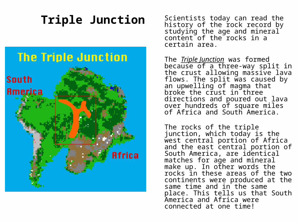
Triple Junction Scientists today can read the history of the rock record by studying the age and mineral content of the rocks in a certain area.
The Triple Junction was formed because of a three-way split in the crust allowing massive lava flows. The split was caused by an upwelling of magma that broke the crust in three directions and poured out lava over hundreds of square miles of Africa and South America.
The rocks of the triple junction, which today is the west central portion of Africa and the east central portion of South America, are identical matches for age and mineral make up. In other words the rocks in these areas of the two continents were produced at the same time and in the same place. This tells us that South America and Africa were connected at one time!
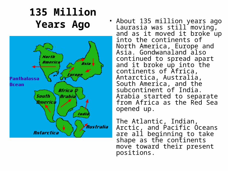
135 Million Years Ago• About 135 million years ago Laurasia was still moving, and as it moved it broke up into the continents of North America, Europe and Asia. Gondwanaland also continued to spread apart and it broke up into the continents of Africa, Antarctica, Australia, South America, and the subcontinent of India. Arabia started to separate from Africa as the Red Sea opened up.
The Atlantic, Indian, Arctic, and Pacific Oceans are all beginning to take shape as the continents move toward their present positions.
Today
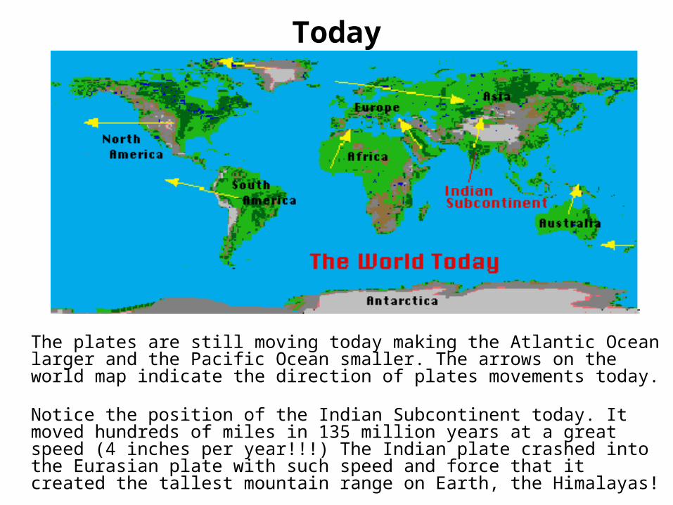
The plates are still moving today making the Atlantic Ocean larger and the Pacific Ocean smaller. The arrows on the world map indicate the direction of plates movements today.
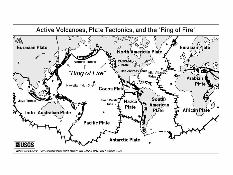
Notice the position of the Indian Subcontinent today. It moved hundreds of miles in 135 million years at a great speed (4 inches per year!!!) The Indian plate crashed into the Eurasian plate with such speed and force that it created the tallest mountain range on Earth, the Himalayas!
Future?
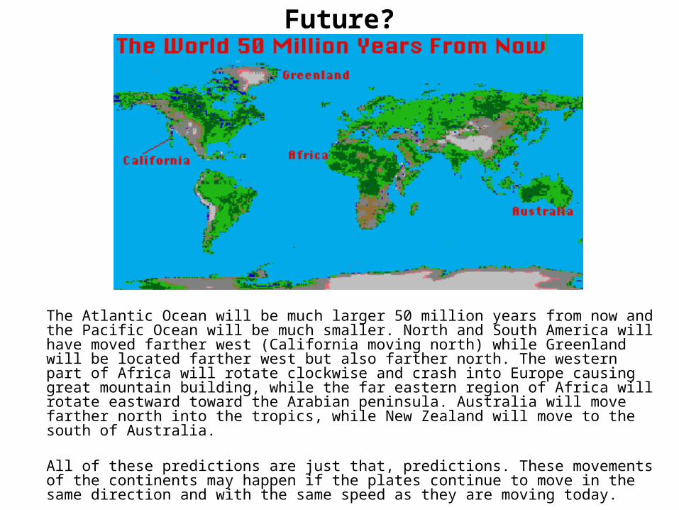
The Atlantic Ocean will be much larger 50 million years from now and the Pacific Ocean will be much smaller. North and South America will have moved farther west (California moving north) while Greenland will be located farther west but also farther north. The western part of Africa will rotate clockwise and crash into Europe causing great mountain building, while the far eastern region of Africa will rotate eastward toward the Arabian peninsula. Australia will move farther north into the tropics, while New Zealand will move to the south of Australia.
All of these predictions are just that, predictions. These movements of the continents may happen if the plates continue to move in the same direction and with the same speed as they are moving today.
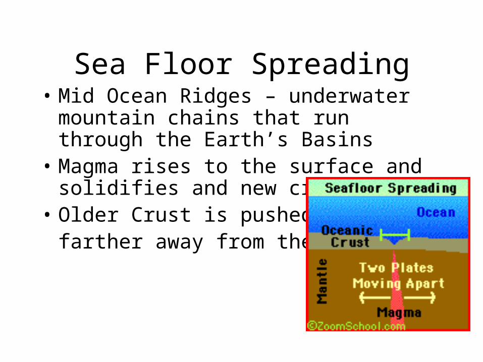
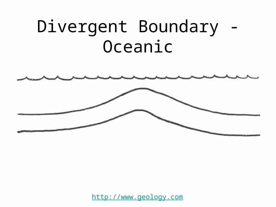
Sea Floor Spreading• Mid Ocean Ridges – underwater mountain
chains that run through the Earth’s Basins• Magma rises to the surface and solidifies
and new crust forms• Older Crust is pushed
farther away from the ridge
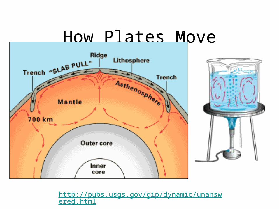
How Plates Move
http://pubs.usgs.gov/gip/dynamic/unanswered.html
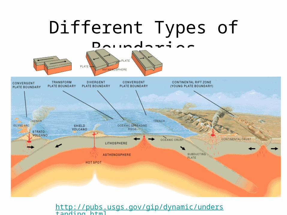
Different Types of Boundaries
http://pubs.usgs.gov/gip/dynamic/understanding.html
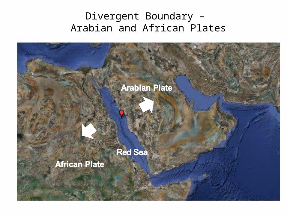
Divergent Boundary – Arabian and African Plates

Divergent Boundary – Iceland
http://pubs.usgs.gov/gip/dynamic/understanding.html
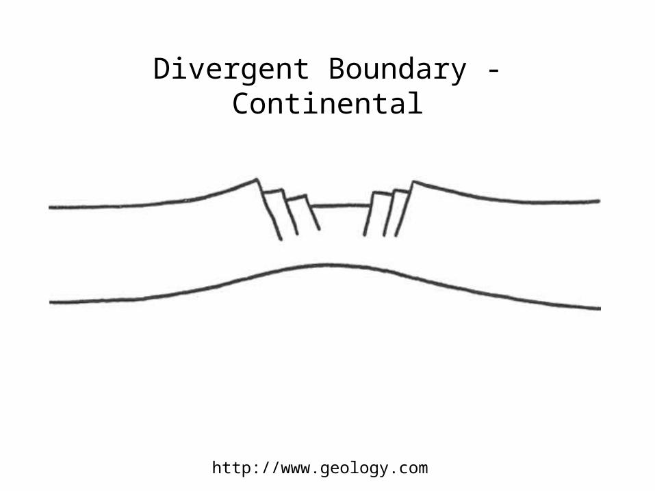
Divergent Boundary - Continental
http://www.geology.com
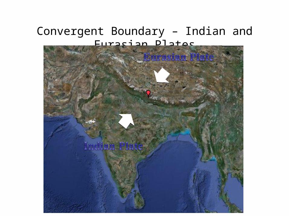
Convergent Boundary – Indian and Eurasian Plates
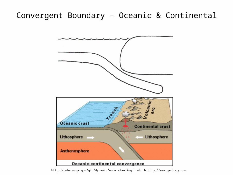
Convergent Boundary – Oceanic & Continental
http://pubs.usgs.gov/gip/dynamic/understanding.html & http://www.geology.com
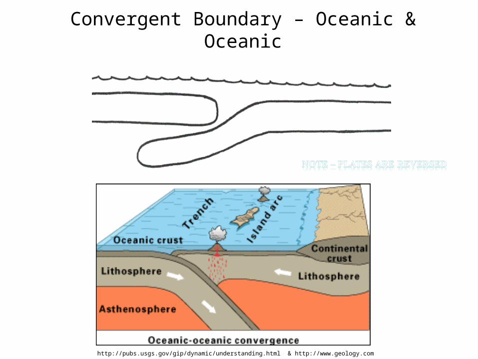
Convergent Boundary – Oceanic & Oceanic
http://pubs.usgs.gov/gip/dynamic/understanding.html & http://www.geology.com
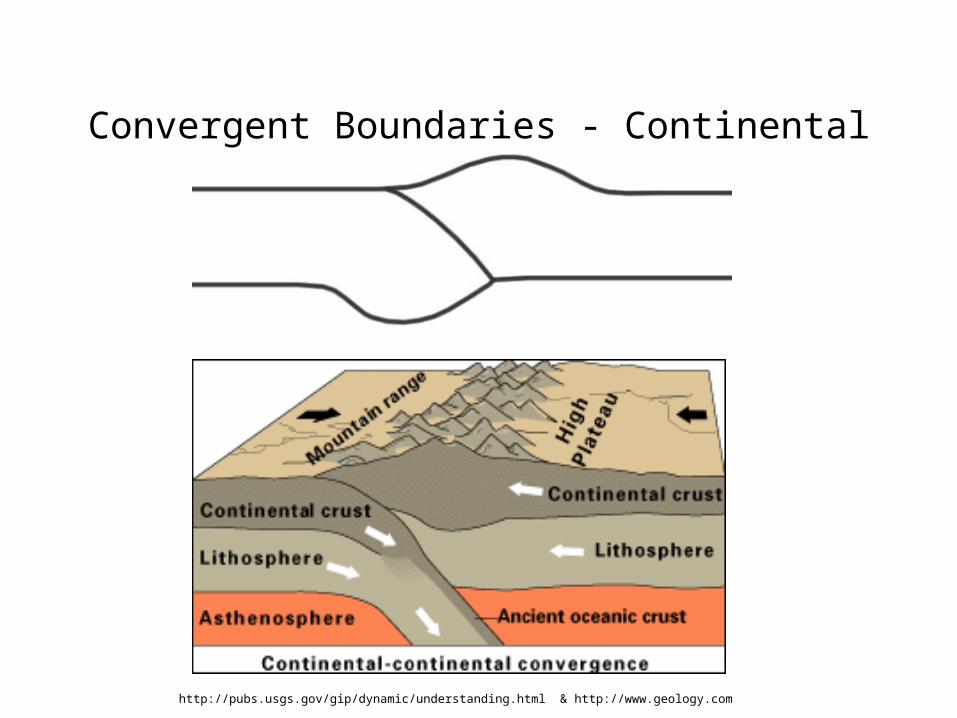
Convergent Boundaries - Continental
http://pubs.usgs.gov/gip/dynamic/understanding.html & http://www.geology.com

Transform Boundary – San Andreas Fault
www.geology.com
Review• Name the 3 main layers of the Earth and their
characteristics
• What is a tectonic plate?
• What is the Continental Drift Theory?
• What was Pangea?
• What is Sea-Floor spreading?
• Name the three different types of plate boundaries and one location on Earth for each one