132
East Ayrshire Local Development Plan Volume 2: Settlement Maps February 2016

East Ayrshire Local Development Plan
Volume 2: Settlement Maps
February 2016

East Ayrshire Local Development Plan: Proposed Plan Maps
LDP maps have been produced for all settlements comprising 15 or more houses and for the
rural area as a whole. These maps:
Identify those housing, industrial and other sites which are considered to provide
opportunities for appropriate new development to the year 2025. Future growth areas
to the year 2035 are also indicatively shown for certain settlements;
Identify those areas which are safeguarded for specific existing uses; and
Indicate specific local plan policies and proposals which relate to any one particular
area.
The Development Opportunity Sites identified on the local development plan maps have all been given unique reference numbers which are cross-referenced to the written statements supporting each map e.g. 017H, 102B, 125M and 230MXD. The letter ‘H’ represents a housing development opportunity site, ‘B’ a business or industrial development opportunity site and ‘M’ a miscellaneous or other development opportunity site. Waste management facilities are safeguarded under policy WM2. These facilities are shown on the local plan maps as ‘WM’ sites. The list of acceptable uses for miscellaneous development opportunity sites is listed in the notes accompanying the maps. A definition of Footfall Generating uses can be found at policy TC2 in volume 1 of the LDP. The ‘MXD’ sites all relate to policy IND4, where limited enabling development (usually housing) will be permitted in order to cross finance business and industrial development. All areas shaded green on the LDP maps are safeguarded open space. Any development proposed on these areas will require to meet with the provisions of policies INF7 and INF8. Notes providing specific requirements for sites are set out in the text. These relate to matters such as transportation, flooding and Strategic Environmental Assessment requirements. In addition to these notes, Scottish Water has indicated that developers are encouraged to engage at the earliest opportunity to discuss the needs of their development. Early engagement with Scottish Water will allow discussion on any major infrastructure issues within an area, but detailed information will only be available after modelling investigations are undertaken. Scottish Water also points out that it is important to note that a Development Impact Assessment may need to be undertaken for some sites, and the need for this will be determined by Scottish Water once the development comes forward. While all attempts have been made to indicate all relevant policy areas on the LDP maps, it has not been possible, in the interests of clarity, to indicate the following on the LDP rural area map:
those areas of land comprising prime quality agricultural land;
non-statutory nature conservation sites such as Provisional Wildlife Sites
The Dark Sky Park
The Galloway and Southern Ayrshire Biosphere All of these categories of land are given a degree of protection by LDP policy and these particular areas, together with the policies which relate to them, are shown on separate policy maps either within the body of the text or as appendices to Volume 1 of the plan.

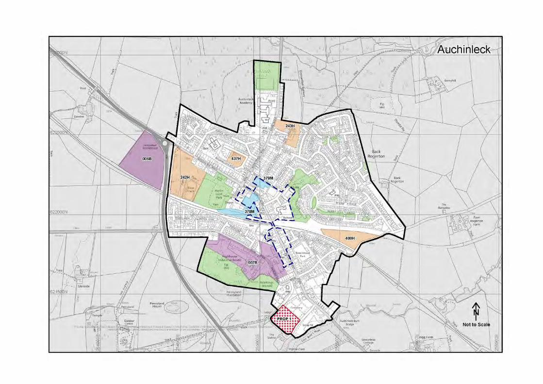
AUCHINLECK
Auchinleck is a local centre with a population of 3,819 in 2011. The town is strategically
located on the A76, 2 miles to the north of Cumnock and close to the increasingly popular
Dumfries House and Auchinleck Estate, important tourism and heritage attractions within
East Ayrshire.
The town centre is focused along the Main Street, which offers a range of local services,
whilst the supermarket at the south end of the town provides for local convenience shopping.
The town is well served in terms of community facilities, with a secondary school, 2 primary
schools and the new Boswell Centre, a community and resource centre with library, day care
centre and community space.
Three relatively large housing sites are designated, to meet demand for housing in the town.
A number of brownfield sites, centrally located within the town, are identified for a range of
commercial and community uses.
AUCHINLECK DEVELOPMENT OPPORTUNITIES
AUCHINLECK 1
Residential development of the following sites will be supported by the Council:
Site Ref Location Capacity Area (ha)
242H Dalshalloch Wood See Notes (i), (iii), (v) and (vi)
86 4.80
243H Hillside Cres See Notes (ii) and (iv)
30 1.53
400H Coal Road See Notes (i), (iii) and (v)
47 2.14
437H+ Dalshalloch Road See Note (ii)
20 0.76
Key + Site identified for affordable housing purposes.
Notes:
(i) The Council will require the developers of sites 242H and 400H to submit a Transport Assessment in respect of any detailed development proposals for the site, identifying the transport effects of the proposal and the sustainable transport measures to be introduced to cater for the travel needs associated with the development. The Council also requires the developer to provide the mitigation and enhancement measures contained within the Environmental Report for the site.
(ii) The Council will require any developer of sites 243H and 437H to submit a Transport
Statement demonstrating that suitable access to the site can be achieved.
(iii) 400H may be susceptible to flooding. Early contact with SEPA and the Ayrshire Roads
Alliance Flooding Officer will be required in this regard.
(iv) Development of Site 243H will increase the vulnerability of the site to flooding as it lies
adjacent to an area at risk from a 1:200 year flood event. A detailed flood risk
assessment will be required to demonstrate that any new development proposals in
the area comply with SPP and EALDP policy ENV 11.
(v) The Council requires the developers of sites 242H and 400H to provide the mitigation
and/or enhancement measures contained within the Environmental Report for these
sites.
(vi) The Council will require the developer of site 242H to prepare a design statement in
line with PAN 68.
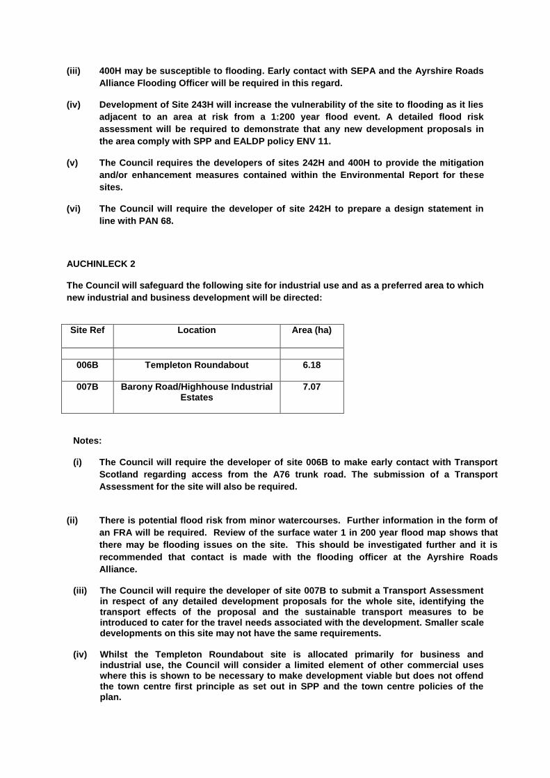
AUCHINLECK 2
The Council will safeguard the following site for industrial use and as a preferred area to which
new industrial and business development will be directed:
Site Ref Location Area (ha)
006B Templeton Roundabout
6.18
007B Barony Road/Highhouse Industrial Estates
7.07
Notes:
(i) The Council will require the developer of site 006B to make early contact with Transport
Scotland regarding access from the A76 trunk road. The submission of a Transport
Assessment for the site will also be required.
(ii) There is potential flood risk from minor watercourses. Further information in the form of
an FRA will be required. Review of the surface water 1 in 200 year flood map shows that
there may be flooding issues on the site. This should be investigated further and it is
recommended that contact is made with the flooding officer at the Ayrshire Roads
Alliance.
(iii) The Council will require the developer of site 007B to submit a Transport Assessment in respect of any detailed development proposals for the whole site, identifying the transport effects of the proposal and the sustainable transport measures to be introduced to cater for the travel needs associated with the development. Smaller scale developments on this site may not have the same requirements.
(iv) Whilst the Templeton Roundabout site is allocated primarily for business and
industrial use, the Council will consider a limited element of other commercial uses where this is shown to be necessary to make development viable but does not offend the town centre first principle as set out in SPP and the town centre policies of the plan.

(v) The Council require the developers of sites 006B and 007B to provide the mitigation
and/or enhancement measures contained within the Environmental Report for the site. (vi) There is a small unnamed watercourse which dissects this site. (vii) A small unnamed tributary of the Lugar Water forms the boundary of the site.
AUCHINLECK 3
The Council will encourage redevelopment of the site for residential, footfall generating, Class 4 (Business), public realm or community uses.
Site Ref Location Area (ha)
378M Main Street
1.67
Notes:
(i) The Council require the developer to provide the mitigation and/or enhancement measures contained within the Environmental Report for the site.
(ii) The Council will require the developer of site 378M to prepare a design statement in
line with PAN 68.
AUCHINLECK 4
The Council will encourage redevelopment of the site for residential, footfall generating, Class 4
(Business) or community uses.
Site Ref Location Area (ha)
379M School Road
0.39
Note:
(i) The Council require the developer to provide the mitigation and enhancement measures contained within the Environmental Report for the site.
PROP 1 The Council will extend Auchinleck Cemetery as shown on the Auchinleck Local Development Plan Map.

BELLSBANK
Located to the south of Dalmellington, Bellsbank is a small settlement with a population of
1,374 in 2011, which enjoys attractive open views of the surrounding hills and countryside.
The town is made up primarily of post-war public housing development and has seen a
significant fall in population (15.1% since 2001), as a result of housing demolitions.
The town is adequately served in terms of community facilities, which include a primary
school and a community centre, and is in close proximity to Dalmellington, the identified
service centre town for the Doon Valley. There is little demand for private development
within Bellsbank and no sites have been identified for future development within this LDP.

BURNSIDE
Situated on the B741 to the south west of New Cumnock, Burnside was originally developed to house workers employed by the deep mining industry. The original development of public sector housing that made up Burnside has largely been demolished. The village is entirely residential and comprises of a handful of the original houses alongside a scattering of new private houses, developed within the footprint of the original village. The environment of the rural village would benefit from improvement and whilst the plan identifies scope for further housing development, this should be in a coordinated approach, in order to re-create a more structured settlement.
BURNSIDE DEVELOPMENT OPPORTUNITIES BURNSIDE 1 Residential development of the following site will be supported by the Council:
Site Ref Location Capacity Area (ha)
245H Burnside
20 2.77
Notes (i) No further piecemeal development will be permitted in the proposed development site
and an overall masterplan will require to be submitted to the Council for consideration and approval, prior to any further development taking place.
(ii) Review of the surface water 1 in 200 year flood map shows that there may be flooding
issues on the site. This should be investigated further and it is recommended that contact is made with the flooding officer at the Ayrshire Roads Alliance.
CATRINE
With a population of 2,236 in 2011, Catrine is identified as a local centre located to the south
east of Mauchline. Catrine originally developed as a mill town in the 1700’s. Whilst the mill
has now been demolished, the water voes and weir that served the mill still remain, and give
the town significant historic interest and a unique character. The restoration of the historic
features of the town form part of a community-led regeneration project within Catrine, which
aims to bring life back into the towns assets, encourage visitors and create a sustainable
income stream for the community.
Catrine is relatively well provided for in terms of community services, which include a small
number of shops, a primary school and a games hall.
A number of brownfield sites and one greenfield site on the edge of the town have been
identified to accommodate a reasonable amount of new housing development as well as
new community and commercial space. Catrine benefits from a significant amount of
greenspace, which is safeguarded to protect the amenity and existing character of the
village.
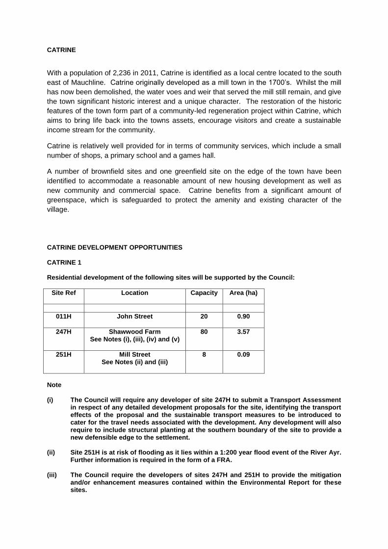
CATRINE DEVELOPMENT OPPORTUNITIES
CATRINE 1
Residential development of the following sites will be supported by the Council:
Site Ref Location Capacity Area (ha)
011H John Street
20 0.90
247H Shawwood Farm See Notes (i), (iii), (iv) and (v)
80 3.57
251H Mill Street See Notes (ii) and (iii)
8 0.09
Note (i) The Council will require any developer of site 247H to submit a Transport Assessment
in respect of any detailed development proposals for the site, identifying the transport effects of the proposal and the sustainable transport measures to be introduced to cater for the travel needs associated with the development. Any development will also require to include structural planting at the southern boundary of the site to provide a new defensible edge to the settlement.
(ii) Site 251H is at risk of flooding as it lies within a 1:200 year flood event of the River Ayr.
Further information is required in the form of a FRA. (iii) The Council require the developers of sites 247H and 251H to provide the mitigation
and/or enhancement measures contained within the Environmental Report for these sites.

(iv) The Council will require the developer of site 247H to prepare a design statement in
line with PAN 68.
(v) Review of the surface water 1 in 200 year flood map shows that there may be flooding
issues on site 247H. This should be investigated further and it is recommended that
contact is made with the flooding officer at the Ayrshire Roads Alliance.
CATRINE 2 The Council will safeguard the following sites for continuing industrial use and as preferred areas to which new industrial and business development will be directed:
Site Ref Location Area (ha)
253B Newton Terrace See Note (i)
0.40
254B Glen Catrine Bonded Warehouse See Note (i)
5.18
Note: (i) Site 253B lies adjacent to the 1:200 year flood extent of the River Ayr. Site 254B lies
within the 1:200 year flood extent of the River Ayr. Further information for both sites will be required in the form of a FRA.
CATRINE 3
The Council will encourage and support the redevelopment of the site for footfall generating and
residential uses.
Site Ref Location Area (ha)
377M Bridge Street
0.07
Notes:
(i) The Council requires the developer to provide the mitigation and/or enhancement measures contained within the Environmental Report for the site.
(ii) The site is located fully within the 1:200 year flood extent of the River Ayr. Additional
information in the form of a FRA will be required.

CATRINE 4
The Council will encourage redevelopment of the site for residential or Class 4 (business) use.
Site Ref Location Area (ha)
380M Newton Terrace See Notes (i) and (ii)
0.63
Note:
(i) The Council requires the developer to provide the mitigation and/or enhancement measures contained within the Environmental Report for the site.
(ii) Review of the surface water 1 in 200 year flood map shows that there may be flooding
issues on the site. This should be investigated further and it is recommended that contact is made with the flooding officer at the Ayrshire Roads Alliance.
PROP 2 The Council will investigate the possibility of extending Catrine Cemetery as shown on the Catrine Local Development Plan Map
PROP 3
The Council will investigate options for upgrading the junction of the B713 road linking Catrine
and Sorn and the B705 road to Auchinleck.

COALHALL
Coalhall is a small hamlet of around 30 dwellings on the A70, approximately 6 miles east of
Ayr. It is essentially residential in nature, but also contains a public house and commercial
bus garage.
Recent development within the village has been in the form of small scale infill development
and no larger scale expansion is being planned for through the LDP.

CRONBERRY
Cronberry is a small linear settlement, in a rural location off the A70 to the west of Muirkirk.
The settlement is entirely residential in nature, containing no commercial or community
facilities.
One housing site for four dwellings is designated, which would form a limited extension to
the existing settlement.
CRONBERRY DEVELOPMENT OPPORTUNITIES
CRONBERRY 1
Residential development of the following site will be supported by the Council:
Site Ref
Location Capacity Area (ha)
255H Riverside Gardens
4 0.33
Notes:
(i) Site 255H lies within the 1:200 year flood extent of the SEPA Flood Map. A minor water course also flows through the site. Further information required in the form of a FRA.
(ii) The Council requires the developer to provide the mitigation and/or enhancement
measures contained within the Environmental Report for the site. (iii) The Council requires the developer to ensure that the development of site 255H does
not have any adverse effects on the integrity of the Muirkirk and North Lowther Upland Special Protection Area and the Airds Moss Special Area of Conservation.

CROOKEDHOLM
Located directly adjacent to Hurlford, to the east of Kilmarnock, Crookedholm is primarily a
residential settlement, served by a handful of local shops and services.
Its close proximity to Kilmarnock and easy access to the A77, make it an appropriate local
centre to accommodate appropriately sited new housing sites. In the absence of any
suitable brownfield sites, two greenfield sites are identified for residential development, with
a combined capacity for 70 new houses.
CROOKEDHOLM DEVELOPMENT OPPORTUNITIES
CROOKEDHOLM 1
Residential development of the following sites will be supported by the Council:
Site Ref Location Capacity Area (ha)
256H Grougar Road East See Notes (i) (ii), (iii) and (v)
50 2.61
361H Main Road (South) See Notes (iv) and (v)
20 0.97
Notes: (i) The Council will require, through an appropriate Section 75 Obligation or planning
condition, for the eastern and northern boundaries of site 256H to be planted with trees to provide a soft urban edge to the development, for screening and amenity purposes and to ensure sensitive integration of the housing area with adjacent areas of countryside.
(ii) The Council will require any developer of site 256H to submit a Transport Assessment
in respect of any detailed development proposal for the site identifying the transport effects of the proposal and the sustainable transport measures to be introduced to cater for the travel needs associated with the development.
(iii) Review of the surface water 1 in 200 year flood map shows that there may be flooding
issues on site 256H. This should be investigated further and it is recommended that
contact is made with the flooding officer at the Ayrshire Roads Alliance.
(iv) Site 361H lies within the 1:200 year flood extent of the SEPA Flood Map. The site is greenfield land, all of which is located within flood extent with a history of flooding. A detailed flood risk assessment will be required to demonstrate that any new development proposal complies with SPP and relevant LDP policy.
(v) The Council require the developers of the sites to provide the mitigation and/or
enhancement measures contained within the Environmental Report for these sites.

CROSSHOUSE
Crosshouse is located approximately 1km to the west of Kilmarnock. The population of the
town was 2,861 in 2011, a 16.6% increase since 2001. The town sits adjacent to
Crosshouse hospital, a large district hospital providing a wide range of services, including
Accident and Emergency for the northern Ayrshire. The town is serviced by a range of local
shops and community services
Two large housing sites are designated within the town, intended to help meet the housing
needs of Crosshouse itself and the wider Kilmarnock area. Development sites have been
avoided close to the eastern boundary to avoid coalescence with Kilmarnock. A brownfield
miscellaneous site is identified, with potential for a range of commercial, residential and
recreational uses.
CROSSHOUSE DEVELOPMENT OPPORTUNITIES
CROSSHOUSE 1
Residential development of the following sites will be supported by the Council:
Site Ref Location Capacity Area (ha)
257H Irvine Rd See Notes (i), (ii) and (v)
30 1.96
258H Kilmaurs Road See Notes (i), (iii) and (v)
140 8.03
Notes: (i) The Council will require any developers of sites 257H and 258H to submit a Transport
Assessments in respect of any detailed development proposal for the sites, identifying the transport effects of the proposal and the sustainable transport measures to be introduced to cater for the travel needs associated with the development.
(ii) The Council require the developer of site 257H to provide the mitigation and/or
enhancement measures contained within the Environmental Report for the site.
(iii) The Council will require the developer of site 258H to prepare a design statement in
line with PAN 68.
(iv) The developer of site 257H will require to provide an appropriate landscape buffer on
that part of the site which adjoins Holm Farm.
(v) Site 257H and 258H lie within or partly within the 1:200 year flood extent of the SEPA
flood map. Further information will be required in the form of a FRA. Review of the
surface water 1 in 200 year flood map shows that there may be flooding issues on the
site. This should be investigated further and it is recommended that contact is made
with the flooding officer at the Ayrshire Roads Alliance.
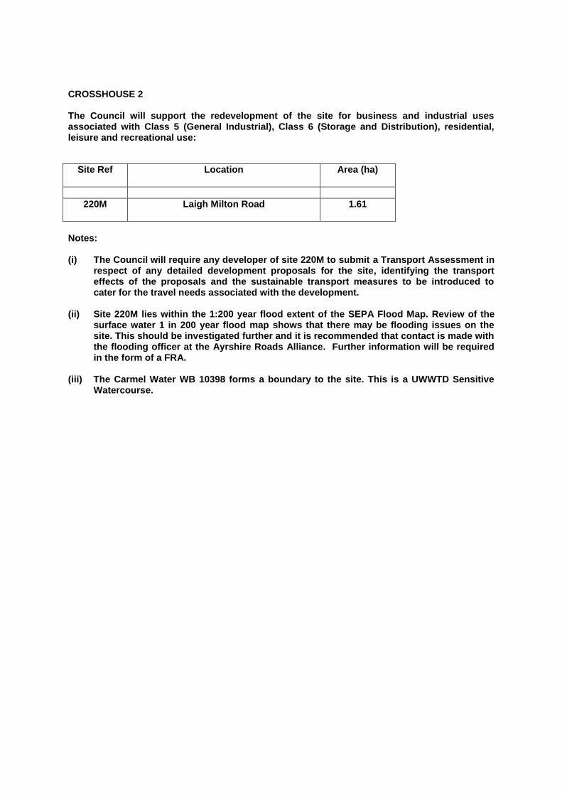
CROSSHOUSE 2 The Council will support the redevelopment of the site for business and industrial uses associated with Class 5 (General Industrial), Class 6 (Storage and Distribution), residential, leisure and recreational use:
Site Ref Location Area (ha)
220M Laigh Milton Road
1.61
Notes: (i) The Council will require any developer of site 220M to submit a Transport Assessment in
respect of any detailed development proposals for the site, identifying the transport effects of the proposals and the sustainable transport measures to be introduced to cater for the travel needs associated with the development.
(ii) Site 220M lies within the 1:200 year flood extent of the SEPA Flood Map. Review of the
surface water 1 in 200 year flood map shows that there may be flooding issues on the site. This should be investigated further and it is recommended that contact is made with the flooding officer at the Ayrshire Roads Alliance. Further information will be required in the form of a FRA.
(iii) The Carmel Water WB 10398 forms a boundary to the site. This is a UWWTD Sensitive
Watercourse.

CUMNOCK
Cumnock is the second largest settlement in East Ayrshire and is an important service
centre for the Southern part of the authority area. In 2011 the population of the town was
9,039, a 3% fall from 2001. The town is centred on an attractive conservation area, which
forms the historic and commercial heart of the town. The adjacent Glaisnock shopping
centre presents a major regeneration opportunity, whilst Woodroad Park offers an attractive,
but under-used recreational resource.
The ongoing development of Knockroon, a sustainable new neighbourhood on the edge of
the town, represents an exciting example of best practice in terms of its design principles
and masterplan approach.
The town is recognised within the spatial strategy as a focus for medium to large scale
development and as a focus for regeneration. Through the Cumnock placemaking strategy,
priority is given to the redevelopment of the Glaisnock shopping centre and complementary
public realm improvements to help rejuvenate the town centre.
Several large housing sites are allocated to meet housing demand within the southern area.
A number of brownfield industrial sites are safeguarded and miscellaneous sites with
potential for business use are identified, in order to direct investment to the town and support
its business base.
Cumnock benefits from significant areas of greenspace throughout the town. These
important areas are safeguarded and, through the placemaking chapter and action
programme, will be improved and extended to increase usage and provide a fully connected
path network.
CUMNOCK DEVELOPMENT OPPORTUNITIES
CUMNOCK 1
Residential development of the following sites will be supported by the Council:
Site Ref Location Capacity Area (ha)
015H Holmhead See Notes (iii) and (v)
47 3.42
262H Cairn Road North See Notes (iii) and (vii)
16 1.82
263H Auchinleck Road See Notes (i), (ii), (iv), (v),
(vi) and (viii)
753 19.68
264H Rigg Road See Notes (i), (iii), (v), (vii)
and (ix)
120 10.49
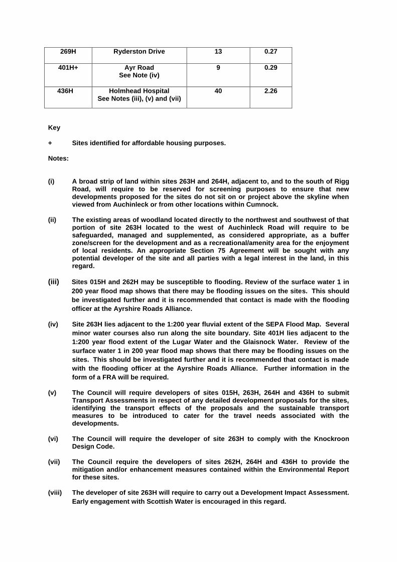
269H Ryderston Drive 13 0.27
401H+ Ayr Road See Note (iv)
9 0.29
436H Holmhead Hospital See Notes (iii), (v) and (vii)
40 2.26
Key + Sites identified for affordable housing purposes. Notes: (i) A broad strip of land within sites 263H and 264H, adjacent to, and to the south of Rigg
Road, will require to be reserved for screening purposes to ensure that new developments proposed for the sites do not sit on or project above the skyline when viewed from Auchinleck or from other locations within Cumnock.
(ii) The existing areas of woodland located directly to the northwest and southwest of that
portion of site 263H located to the west of Auchinleck Road will require to be safeguarded, managed and supplemented, as considered appropriate, as a buffer zone/screen for the development and as a recreational/amenity area for the enjoyment of local residents. An appropriate Section 75 Agreement will be sought with any potential developer of the site and all parties with a legal interest in the land, in this regard.
(iii) Sites 015H and 262H may be susceptible to flooding. Review of the surface water 1 in
200 year flood map shows that there may be flooding issues on the sites. This should
be investigated further and it is recommended that contact is made with the flooding
officer at the Ayrshire Roads Alliance.
(iv) Site 263H lies adjacent to the 1:200 year fluvial extent of the SEPA Flood Map. Several
minor water courses also run along the site boundary. Site 401H lies adjacent to the
1:200 year flood extent of the Lugar Water and the Glaisnock Water. Review of the
surface water 1 in 200 year flood map shows that there may be flooding issues on the
sites. This should be investigated further and it is recommended that contact is made
with the flooding officer at the Ayrshire Roads Alliance. Further information in the
form of a FRA will be required.
(v) The Council will require developers of sites 015H, 263H, 264H and 436H to submit Transport Assessments in respect of any detailed development proposals for the sites, identifying the transport effects of the proposals and the sustainable transport measures to be introduced to cater for the travel needs associated with the developments.
(vi) The Council will require the developer of site 263H to comply with the Knockroon
Design Code. (vii) The Council require the developers of sites 262H, 264H and 436H to provide the
mitigation and/or enhancement measures contained within the Environmental Report for these sites.
(viii) The developer of site 263H will require to carry out a Development Impact Assessment.
Early engagement with Scottish Water is encouraged in this regard.
(ix) The Council will require the developer of site 264H to prepare a design statement in
line with PAN 68.
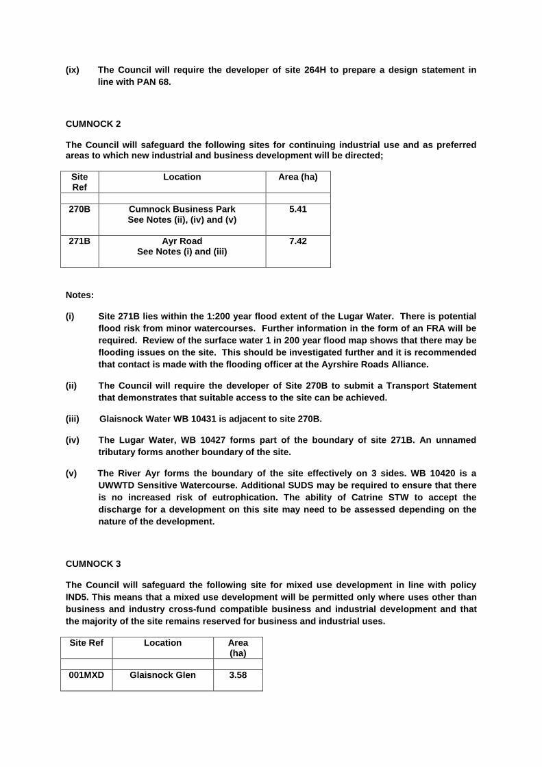
CUMNOCK 2 The Council will safeguard the following sites for continuing industrial use and as preferred areas to which new industrial and business development will be directed;
Site Ref
Location Area (ha)
270B Cumnock Business Park See Notes (ii), (iv) and (v)
5.41
271B Ayr Road See Notes (i) and (iii)
7.42
Notes:
(i) Site 271B lies within the 1:200 year flood extent of the Lugar Water. There is potential
flood risk from minor watercourses. Further information in the form of an FRA will be
required. Review of the surface water 1 in 200 year flood map shows that there may be
flooding issues on the site. This should be investigated further and it is recommended
that contact is made with the flooding officer at the Ayrshire Roads Alliance.
(ii) The Council will require the developer of Site 270B to submit a Transport Statement
that demonstrates that suitable access to the site can be achieved.
(iii) Glaisnock Water WB 10431 is adjacent to site 270B.
(iv) The Lugar Water, WB 10427 forms part of the boundary of site 271B. An unnamed
tributary forms another boundary of the site.
(v) The River Ayr forms the boundary of the site effectively on 3 sides. WB 10420 is a
UWWTD Sensitive Watercourse. Additional SUDS may be required to ensure that there
is no increased risk of eutrophication. The ability of Catrine STW to accept the
discharge for a development on this site may need to be assessed depending on the
nature of the development.
CUMNOCK 3
The Council will safeguard the following site for mixed use development in line with policy
IND5. This means that a mixed use development will be permitted only where uses other than
business and industry cross-fund compatible business and industrial development and that
the majority of the site remains reserved for business and industrial uses.
Site Ref Location Area (ha)
001MXD Glaisnock Glen
3.58

Notes:
(i) Review of the surface water 1 in 200 year flood map shows that there may be flooding
issues on the site. This should be investigated further and it is recommended that
contact is made with the flooding officer at the Ayrshire Roads Alliance.
(ii) The Council will require the developer to prepare a Masterplan for the site. The Council
should be consulted on the Masterplan at an early stage in its preparation and the
Masterplan should be submitted for formal consideration to the Council prior to any
planning application being lodged.
(iii) The Council require the developer to provide the mitigation and/or enhancement measures contained within the Environmental Report for the site.
(iv) The Council will produce a design brief to guide development of site 001MXD. (v) A Section 75 obligation will be required, to ensure the business and industrial use of
the site is secured.
CUMNOCK 4
The Council will support the redevelopment of the site to provide footfall generating uses, car parking and high quality landscaping; environmental improvements and the creation of high quality civic space within the following site:
Site Ref
Location Area (ha)
024M Glaisnock Street /Greenholm Road
2.78
Notes:
(i) Development of site 024M will require to implement and be compatible with the LDP
Place Making plans for Cumnock and Cumnock Town Centre
(ii) The site is at risk of flooding as it lies within a 1:200 year flood event as shown on
SEPA’s Flood Map. A detailed flood risk assessment will be required to demonstrate
that any new development proposal complies with SPP and relevant LDP policy.
Review of the surface water 1 in 200 year flood map shows that there may be flooding
issues on the site. This should be investigated further and it is recommended that
contact is made with the flooding officer at the Ayrshire Roads Alliance.
(iii) The Glaisnock Water, WB 10431, flows through this site.
CUMNOCK 5
The Council will safeguard the following site for mixed use development including community
uses, garden centre, car showroom, business and industry and housing. Retailing ancillary to
a use considered appropriate for the site will also be permitted where this is consistent with
the retail policies in the plan.

Site Ref Location Area (ha)
383M Caponacre See Notes (i), (ii), (iii), (iv) and (v)
22.26
Notes:
(i) The Council will require any developers of the site to submit a Transport Assessment in respect of any significant development proposals, identifying the transport effects of the proposals and the sustainable transport measures to be introduced to cater for the travel needs associated with the developments.
(ii) There is potential flood risk from Horsecleugh Burn and Glaisnock Water on the
eastern boundary of the site. Further information in the form of an FRA will be
required. The potential flooding issues on the site should be investigated further and it
is recommended that contact is made with the flooding officer at the Ayrshire Roads
Alliance.
(iii) The Council require the developer to provide the mitigation and/or enhancement
measures contained within the Environmental Report for the site.
(iv) The Council will prepare a brief for the development of site 383M in consultation with
stakeholders who have an interest in the site.
(v) The Glaisnock Water, WB 10431 and the Horsecleugh Burn flow through the site.
CUMNOCK 6
The LDP safeguards the following site for waste management purposes.
Site Ref
Location Area (ha)
008W Underwood Depot, Underwood Road
1.18
CUMNOCK PROPOSALS
PROP 4
The Council will encourage and support the implementation of the Cumnock placemaking
plans set out in Volume 1 of the LDP.
PROP 5
The Council will continue to investigate the development of a new education and community
campus at Broomfield Park, Cumnock. A masterplan approach will be taken to the
development of the site.

PROP 6 The Council will investigate the possibility of extending Cumnock Cemetery as shown on the Cumnock Local Development Plan Map.

DALMELLINGTON
Situated within the Doon Valley, Dalmellington is East Ayrshire’s southernmost town, with a
population of approximately 1,400 in 2011. Traditionally a mining town, Dalmellington
contains a historic core protected by conservation area status, a small cluster of shops and
services and a range of community facilities including a leisure centre, library and secondary
school. Burnton is a small village of around 70 houses, to the north of Dalmellington. It has
no commercial or community facilities, but is in very close proximity to Dalmellington itself.
Dalmellington acts as a focus for future development both to serve the needs of local
communities within the Doon Valley and to broaden the economic base of the area. The
town is well located on the edge of the Dark Sky Park and in close proximity to the Dark Sky
Observatory, giving it potential to tap into the expanding local tourism market. The
placemaking strategy for the town aims to address vacant buildings and gap sites within the
town centre and to provide missing links within the towns paths and green infrastructure
networks.
The plan identifies several residential opportunity sites of varying size and two brownfield miscellaneous sites with potential for a range of commercial and residential uses. DALMELLINGTON DEVELOPMENT OPPORTUNITIES
DALMELLINGTON 1 Residential development of the following sites will be supported by the Council:
Site Ref Location Capacity Area (ha)
076H Ayr Road (1) See Notes (i) and (iii)
20 0.98
224H The Glebe See Note (i)
30 1.71
272H Carsphairn Road See Notes (i) and (iii)
8 0.44
276H Sillyhole See Notes (i), (ii) and
(iii)
70 3.89
202H Melling Terrace (i) 5 0.24
Note: (i) Sites 076H, 224H, 272H and 276H are at risk of flooding as they lie within, partly within,
or adjacent to the 1:200 year flood extent of the SEPA Flood Map. Further information in the form of a FRA will be required for all sites. In terms of site 202H, there is potential flood risk from minor watercourses. Further information in the form of an FRA required.

(ii) The Council will require any developer of site 276H to submit a Transport Assessment in respect of any detailed development proposals for the site, identifying the transport effects of the proposal and the sustainable transport measures to be introduced to cater for the travel needs associated with the development.
(iii) The Council requires the developers of sites 076H, 272H and 276H to provide the
mitigation and/or enhancement measures contained within the Environmental Report for these sites.
DALMELLINGTON 2 The Council will encourage and support the redevelopment of the site for particular needs housing or footfall generating uses. Redevelopment of the site should be in keeping with the character and appearance of the Dalmellington Conservation Area.
Site Ref Location Area (ha)
077M Croft Street
0.82
Note:
(i) The site is at flood risk from a 1:200 year flood event as shown on SEPA’s Flood Maps. A detailed flood risk assessment will be required to demonstrate that any new development proposal complies with SPP and relevant LDP policy.
DALMELLINGTON 3 The Council will encourage and support the sympathetic redevelopment of the site Class 4 (Business), residential, community facility or hotel/guesthouse uses. Redevelopment of the site should be in keeping with the character and appearance of the Dalmellington Conservation Area.
Site Ref Location Area (ha)
078M High Street
0.08
Notes: (i) The Council requires the developer of site to provide the mitigation and/or
enhancement measures contained within the Environmental Report for the site. (ii) The site is at flood risk from a 1:200 year flood extent of the SEPA Flood Maps. Further
information in the form of a FRA will be required. PROP 7 The Council will investigate the possibility of extending Dalmellington Cemetery as shown on the Dalmellington Local Development Plan Map. PROP 8
The Council will encourage and support the implementation of the Dalmellington placemaking
plan set out in Volume 1 of the LDP.

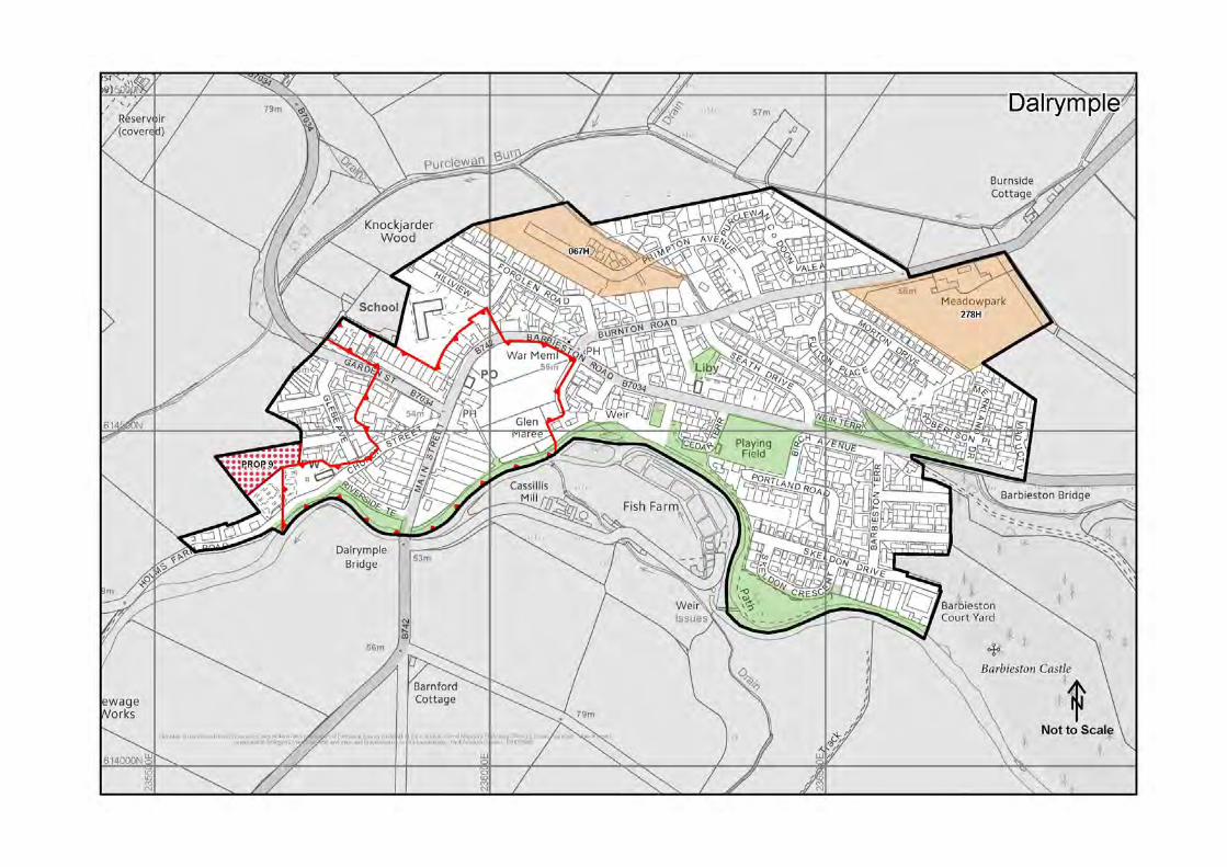
DALRYMPLE
With a population of approximately 1,500 in 2011, Dalrymple has seen a considerable
increase in population of 20% since 2001. The centre of the village is an attractive
conservation area with a small handful of shops which are accompanied by a limited range
of community facilities to meet local needs.
Only a few miles from Ayr, the village has seen considerable demand for new housing
development in recent years. It is considered that Dalrymple offers scope to meet local
housing need, in line with its status as local centre, and there are two generously sized
residential opportunity sites allocated in this regard.
DALRYMPLE DEVELOPMENT OPPORTUNITIES DALRYMPLE1 Residential development of the following sites will be supported by the Council:
Site Ref Location Capacity Area (ha)
067H Burnton Road See Note (ii)
37 2.00
278H Burnton Rd (S) See Notes (i), (ii) and (iii)
45 2.82
Notes (i) The Council will require, through an appropriate Section 75 Obligation or planning condition, for the eastern and southern boundaries of site 278H to be planted with trees to provide a soft urban edge to the development, for screening and amenity purposes and to ensure sensitive integration of the housing area with adjacent areas of countryside. (ii) Sites 067H and 278H are at risk of flooding as they lie within the 1:200 year flood extent of the SEPA Flood Map. A detailed flood risk assessment will be required to demonstrate that any new development proposal complies with SPP and relevant LDP policy. (iii) The Council require the developers of sites 278H to provide the mitigation and/or enhancement measures contained within the Environmental Report for the site.
DALRYMPLE PROPOSALS PROP 9 The Council will investigate the possibility of extending Dalrymple Cemetery as shown on the Dalrymple Local Development Plan Map.

DARVEL AND PRIESTLAND
With a population of 3,900, Darvel is strategically located within the Irvine Valley corridor,
which connects East Ayrshire to the M74 and beyond. Darvel is an attractive settlement with
a strong industrial heritage based around the weaving and lace industries. The town has two
conservation areas and a town centre with a selection of local shops, focused along West
Main Street, the main route through the town.
Identified as a local centre within the spatial strategy, several brownfield sites are identified
as development opportunity sites, both for residential and business/industrial uses. A
miscellaneous redevelopment site within the town centre and conservation area is identified
for residential or footfall generating uses. The development of this site will significantly
enhance the amenity of the town centre and should be carried out to a high standard, in
keeping with character and quality of the conservation area.
Priestland comprises of a handful of dwellings, directly to the east of Darvel. The village is
included as a rural village within the spatial strategy. No new development is planned for
Priestland through the plan.
DARVEL & PRIESTLAND DEVELOPMENT OPPORTUNITIES DARVEL1 Residential development of the following sites will be supported by the Council:
Site Ref Location Capacity Area (ha)
103H Burn Road See Notes (i) and (iii)
19 0.78
204H+ Lochore Terrace 13 0.36
280H Hillview Road See Note (i)
9 0.81
281H Jamieson Rd (2) See Notes (i) and (ii)
40 2.69
Key + Sites identified for affordable housing purposes.
Notes:
(i) Sites 103H, 280H and 281H (western boundary of each site) are at potential flood risk from a minor watercourse. Further information in the form of a FRA will be required. (ii) The Council will require any developer of site 281H to submit a Transport Statement demonstrating that suitable access to the site can be achieved. (iii) The Council requires the developers of sites 103H to provide the mitigation and/or enhancement measures contained within the Environmental Report for the site.

DARVEL 2 The Council will safeguard the following sites for continuing industrial use and as preferred areas to which new industrial and business development will be directed:
Site Ref
Location Area (ha)
283B Campbell Street See Note (i)
0.75
285B Jamieson Rd / Green St See Note (i)
0.87
Note: (i) Review of the surface water 1 in 200 year flood map shows that there may be flooding issues on sites 283B and 285B. This should be investigated further and it is recommended that contact is made with the flooding officer at the Ayrshire Roads Alliance. DARVEL 3 The Council will safeguard the following site for mixed use development in line with policy
IND4. This means that a mixed use development including residential and business and
industrial will be permitted only where the housing element cross-funds compatible business
and industrial development and that the majority of the site remains reserved for business and
industrial uses.
Site Ref Location Area (ha)
002MXD East Main Street
1.14
Notes:
(i) The site lies within the 1:200 year flood extent of the SEPA Flood Map. Further
information will be required in the form of a FRA. Review of the surface water 1 in 200
year flood map shows that there may be flooding issues on the site. This should be
investigated further and it is recommended that contact is made with the flooding
officer at the Ayrshire Roads Alliance.
(ii) The Council require the developer of site to provide the mitigation and/or enhancement
measures contained within the Environmental Report for the site.
(iii) The Council will produce a design brief to guide development of site 002MXD. (iv) A Section 75 obligation will be required, to ensure the business and industrial use of
the site is secured. (v) The River Irvine WB 10393 forms a boundary of the site.

DARVEL 4
The Council will support and encourage the redevelopment of the site for footfall generating
uses, as well as residential flats and sensitive Class 4 (Business) where this is in keeping with
the town centre location.
Site Ref Location Area (ha)
375M Former co-op building, corner of Ranaldcoup Rd and East Main Street
0.13
Note: (i) The Council require the developer of site to provide the mitigation and/or enhancement
measures contained within the Environmental Report for the site.

DRONGAN
Located within an attractive rural setting, Drongan developed as a large scale public sector
housing scheme dissected by a large central area of public open space. The town has a
population of approximately 3,200 (in 2011) and is identified as a local centre within the
spatial strategy. The town has an adequate supply of local shops and community facilities
and benefits from a large central area of recreational open space.
Due to its setting and physical characteristics as well as its close proximity to Ayr, the town
has capacity for a considerable amount of future growth. The town has limited brownfield
sites available, therefore several greenfield residential sites are identified. Two sites are
safeguarded for continued and increased business and industrial use in order to support
commercial activity within the town.
DRONGAN DEVELOPMENT OPPORTUNITIES DRONGAN 1 Residential Development of the following sites will be supported by the Council:
Site Ref Location Capacity Area (ha)
287H Robert Burns Avenue 19 0.80
289H Watson Terrace See Notes (ii), (iii), (v) and
(vi)
95 5.30
273H Mill O’Shield Road See Notes (i), (iii), (iv) and
(v)
60 3.16
292H Littlemill Road C See Notes (i) and (v)
24 0.85
403H Littlemill Road A See Notes (i) and (v)
4 0.10
Notes: (i) Sites 273H, 292H and 403H are at risk of flooding as they lie within a 1:200 year flood
extent of the SEPA Flood Map. Further information will be required in the form of a FRA. Review of the surface water 1 in 200 year flood map shows that there may be flooding issues on the site. This should be investigated further and it is recommended that contact is made with the flooding officer at the Ayrshire Roads Alliance.
(ii) The Council will require, through an appropriate Section 75 Obligation or planning
condition, for the northern boundary of site 289H to be planted with trees to provide a soft urban edge to the development for screening and amenity purposes and to ensure sensitive integration of the housing areas with adjacent areas of countryside.

(iii) The Council will require any developer of site 273H and 289H to submit Transport Assessments in respect of any detailed development proposals for the sites, identifying the transport effects of the proposals and the sustainable transport measures to be introduced to cater for the travel needs associated with the development.
(iv) Any development on site 273H will require to include structural planting to effectively
define a clear, defensible western boundary. (v) The Council require the developers of sites 273H, 289H, 292H and 403H to provide the
mitigation and/or enhancement measures contained within the Environmental Report for these sites.
(vi) The Council will require the developer of site 289H to prepare a design statement in
line with PAN 68.
DRONGAN 2 The Council will safeguard the following sites for continuing industrial use and as preferred areas to which new industrial and business development will be directed:
Site Ref Location Area (ha)
293B Drongan Industrial Estate 0.44
294B Littlemill Road See Note (i) and (ii)
1.12
Note:
(i) Site 294B lies within the 1:200 year flood extent of the SEPA Flood Map. Further information will be required in the form of a FRA.
(ii) The Taiglum Burn, WB 10424, forms a boundary of the site. This burn is a UWWTD
Sensitive Water. PROP 10 The Council will extend Drongan cemetery as shown on the Drongan Local Development Plan Map.

DUNLOP
Dunlop is an attractive village in the northern part of East Ayrshire which benefits from a well
preserved conservation area and a small selection of local shops and community facilities.
Due to its location close to the Glasgow conurbation and its direct train link to the city, the
village is has proved popular for new housing development in recent years with a resultant
increase in population of 34% between 2001 and 2011, the largest increase of all East
Ayrshire settlements.
The village has seen a significant expansion in recent years as a result of a large housing
development which was constructed on a former industrial area and, in order to preserve the
character of this conservation village and in keeping with its status as a local centre, no
further major development is planned through this LDP with only one small site being
designated for new residential development.
DUNLOP DEVELOPMENT OPPORTUNITIES DUNLOP1 Residential development of the following sites will be supported by the Council:
Site Ref
Location Capacity Area (ha)
404H Stewarton Road
See Note (i)
5 0.42
Notes:
(i) Site 404H lies within the 1:200 year flood extent of the SEPA Flood Maps. Further information will be required in the form of a FRA.
(ii) The Council requires the developer of the site to provide the mitigation and/or
enhancement measures contained within the Environmental Report for the site.

FENWICK AND LAIGH FENWICK
Fenwick and Laigh Fenwick are two physically distinct settlements, separated by a narrow
stretch of open countryside. Both are attractive settlements with conservation areas at their
heart and have a combined population of just over 1,000 (in 2011). Both settlements are
predominantly residential in nature, with Fenwick containing a small handful of shops and
services.
Fenwick and Laigh Fenwick benefit from quick access to the M77 motorway, contributing to
the considerable demand for new residential development within the settlements. Fenwick is
identified as a local centre within the settlement hierarchy. The LDP identifies land for a
considerable level of new residential development in Fenwick, with one additional site in
Laigh Fenwick. In allocating sites, special attention has been given to the need to preserve
the integrity of both villages and prevent their coalescence.
FENWICK & LAIGH FENWICK DEVELOPMENT OPPORTUNITIES FENWICK & LAIGH FENWICK 1 Residential development of the following sites will be supported by the Council:
Site Ref Location Capacity Area (ha)
174H Skernieland Road See Notes (i), (ii) & (iii)
38 2.51
297H Kilmaurs Rd
18 1.12
405H Dunselma See Notes (iii) and (iv)
20 1.31
441H Stewarton Road (North) 20 2.00
Notes (i) The Council will seek a Section 75 Obligation with any potential housing developer of
site 174H with regard to the provision of vehicular access to serve the proposed new Fenwick Cemetery car park.
(ii) The Council will require any developer of site 174H to submit a Transport Assessment in
respect of any detailed development proposals for the site, identifying the transport effects of the proposals and the sustainable transport measures to be introduced to cater for the travel needs associated with the development.
(iii) Sites 174H and 405H lie partly within the 1:200 year flood extent of the SEPA’s Flood
Map. Site 441H may be at risk from flooding. Further information for these sites will be required in the form of a FRA.
(iv) The Council requires the developers of sites 405H and 441H to provide the mitigation
and/or enhancement measures contained within the Environmental Report for these sites.

(v) Review of the surface water 1 in 200 year flood map shows that there may be flooding issues on site 297H. This should be investigated further and it is recommended that contact is made with the flooding officer at the Ayrshire Roads Alliance.
FENWICK & LAIGH FENWICK PROPOSALS PROP 11 The Council will extend Fenwick Cemetery as shown on the Fenwick Local Development Plan Map and provide a new car park within the extended cemetery area.

GALSTON
With a population of 5,000, Galston is the largest settlement within the Irvine Valley sub area
and is identified in the LDP as a town to serve the wider community. Galston has an
important role to play in meeting the day to day needs of Irvine Valley residents, in terms of
providing convenience retailing, a high school and a range of community and commercial
facilities. The town centre of Galston is identified as a conservation area, containing a
number of listed buildings, and is the subject of regeneration activity including a
Conservation Area Regeneration Scheme.
The Plan enhances Galston’s role as a service centre for the Irvine Valley and allocates
appropriate sites to support this. Several residential sites of varying size are identified and
an indication is given as to where future growth is most appropriate. A number of
miscellaneous sites are allocated for a range of commercial and footfall generating uses.
The placemaking chapter of the LDP identifies proposals to bring forward key improvements
to Galston, supported through the Action Programme.
GALSTON DEVELOPMENT OPPORTUNITIES
GALSTON 1 Residential development of the following sites will be supported by the Council:
Site Ref Location Capacity Area (ha)
106H Titchfield St. See Note (i)
8 0.13
107H Belvedere View See Notes (i), (ii), (iii) &
(iv)
117 5.47
109H Brewland St. See Note (i)
18 0.92
407H Garden St
7 0.36
408H+ Chapel Lane See Note (i)
30 1.16
409H+ Brewland St (2)
10 0.31
Key + Sites identified for affordable housing purposes. Notes (i) Sites 106H and 408H lie within the 1:200 year flood event of the SEPA Flood Map. Further
information will be required in the form of a FRA. The flooding issue should be
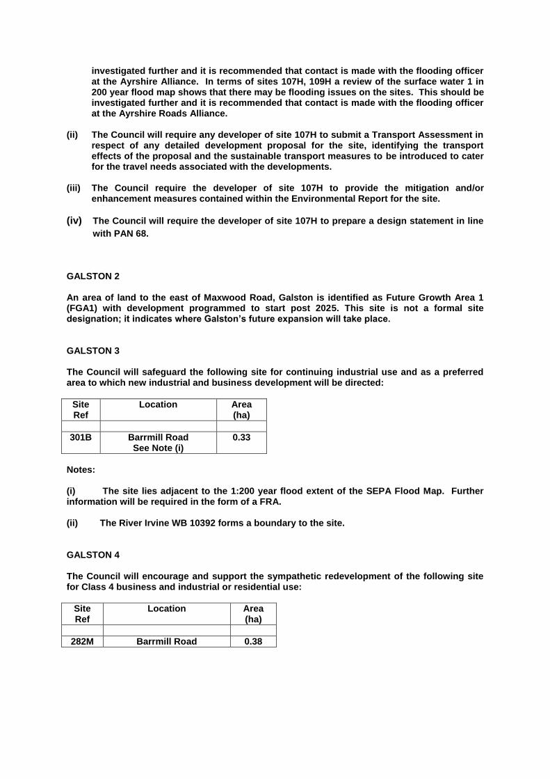
investigated further and it is recommended that contact is made with the flooding officer at the Ayrshire Alliance. In terms of sites 107H, 109H a review of the surface water 1 in 200 year flood map shows that there may be flooding issues on the sites. This should be investigated further and it is recommended that contact is made with the flooding officer at the Ayrshire Roads Alliance.
(ii) The Council will require any developer of site 107H to submit a Transport Assessment in
respect of any detailed development proposal for the site, identifying the transport effects of the proposal and the sustainable transport measures to be introduced to cater for the travel needs associated with the developments.
(iii) The Council require the developer of site 107H to provide the mitigation and/or
enhancement measures contained within the Environmental Report for the site.
(iv) The Council will require the developer of site 107H to prepare a design statement in line
with PAN 68.
GALSTON 2 An area of land to the east of Maxwood Road, Galston is identified as Future Growth Area 1 (FGA1) with development programmed to start post 2025. This site is not a formal site designation; it indicates where Galston’s future expansion will take place. GALSTON 3 The Council will safeguard the following site for continuing industrial use and as a preferred area to which new industrial and business development will be directed:
Site Ref
Location Area (ha)
301B Barrmill Road See Note (i)
0.33
Notes: (i) The site lies adjacent to the 1:200 year flood extent of the SEPA Flood Map. Further information will be required in the form of a FRA. (ii) The River Irvine WB 10392 forms a boundary to the site. GALSTON 4 The Council will encourage and support the sympathetic redevelopment of the following site for Class 4 business and industrial or residential use:
Site Ref
Location Area (ha)
282M Barrmill Road 0.38

Notes:
(i) The Council require the developer of site to provide the mitigation and/or enhancement measures contained within the Environmental Report for the site.
(ii) The site is located adjacent to the 1:200 year flood extent of the SEPA Flood Map.
Further information will be required in the form of an FRA required.
GALSTON 5 The Council will encourage the redevelopment of the site for footfall generating uses, residential, Class 4 (Business) and civic space, where this is in keeping with the town centre location and sensitive to the character and setting of the Conservation Area.
Site Ref
Location Area (ha)
376M Cross Street/Bridge St 0.02
Note:
(i) The site is adjacent to the 1:200 year flood extent of the SEPA Flood Map. Further
information required in the form of a FRA.
GALSTON 6
The Council will encourage the redevelopment of the site for footfall generating uses, residential and Class 4 (Business), where this is in keeping with the town centre location and sensitive to the character of the Conservation Area.
Site Ref
Location Area (ha)
382M Bridge St 0.10
Notes:
(i) The Council require the developer of site to provide the mitigation and/or enhancement measures contained within the Environmental Report for the site.
(ii) The site is located within the 1:200 year flood extent of the SEPA Flood Map. Review of
the surface water 1 in 200 year flood map shows that there may be flooding issues on the site. This should be investigated further and it is recommended that contact is made with the flooding officer at the Ayrshire Roads Alliance. Further information will be in the form of a FRA.
(iii) The Burn Anne forms one boundary of the site.
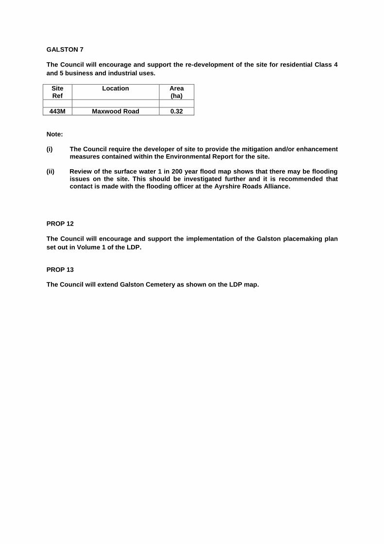
GALSTON 7
The Council will encourage and support the re-development of the site for residential Class 4
and 5 business and industrial uses.
Site Ref
Location Area (ha)
443M Maxwood Road 0.32
Note:
(i) The Council require the developer of site to provide the mitigation and/or enhancement measures contained within the Environmental Report for the site.
(ii) Review of the surface water 1 in 200 year flood map shows that there may be flooding
issues on the site. This should be investigated further and it is recommended that contact is made with the flooding officer at the Ayrshire Roads Alliance.
PROP 12
The Council will encourage and support the implementation of the Galston placemaking plan
set out in Volume 1 of the LDP.
PROP 13 The Council will extend Galston Cemetery as shown on the LDP map.

GATEHEAD
Situated close to East Ayrshire Council’s north western boundary, Gatehead is identified in
the settlement hierarchy as a rural village. Aside from a public house and car sales business
on the main road through the village, it is predominantly residential in nature.
No new development in Gatehead is planned for through the LDP.

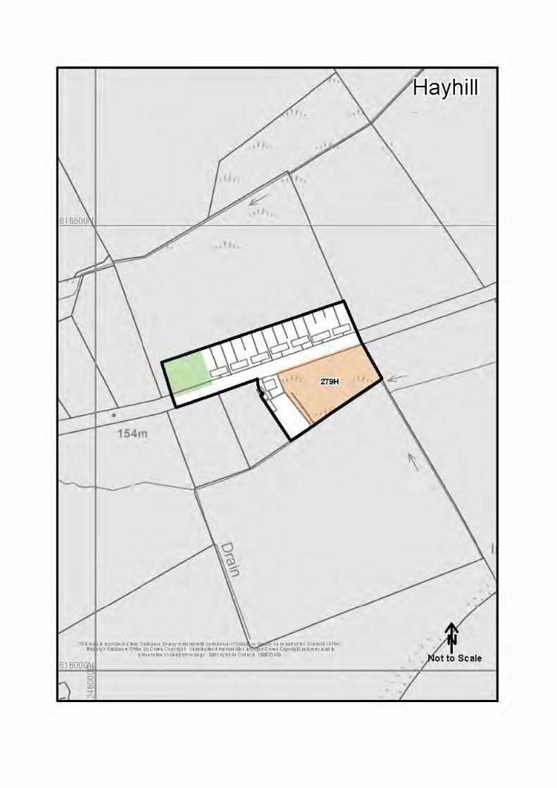
HAYHILL
Situated a few miles to the south of Drongan, Hayhill comprises of 15 houses and a small
playpark. Hayhill is identified as a rural village within the settlement hierarchy.
The plan identifies a small residential site with capacity for 4 houses, which would form an
appropriate extension to the existing community.
HAYHILL DEVELOPMENT OPPORTUNITIES HAYHILL 1 Residential development at the following site will be supported by the Council:
Site Ref
Location Capacity Area (ha)
279H Hayhill Cottages 4 0.60
Note:
(i) There is potential flood risk on site 279H from minor watercourse. Further information will be required in the form of an FRA required. Review of the surface water 1 in 200 year flood map shows that there may be flooding issues on the site. This should be investigated further and it is recommended that contact is made with the flooding officer at the Ayrshire Roads Alliance.
(ii) The Council require the developer of site to provide the mitigation and/or enhancement
measures contained within the Environmental Report for the site.

HOLLYBUSH AND SKELDON MILLS
Located close to East Ayrshire Council’s south western boundary and just a few miles from
Ayr, Hollybush is a small rural settlement of around 25 houses. The settlement has been
developed to its logical boundaries as defined by the surrounding main roads and railway
line and accordingly no new sites are allocated within Hollybush.
Skeldon Mill is a dispersed rural hamlet comprising of a number of individual large, executive
style houses in a wooded setting. The former Mill premises on the banks of the River Doon
have been redeveloped as a small industrial estate. No further expansion of Skeldon Mill is
envisaged.

HURLFORD
With a population of approximately 4,800 in 2011, Hurlford shares a common boundary with
adjacent Crookedholm and is located immediately to the east of Kilmarnock. The town is well
served in terms of local commercial and community services.
Hurlford is within the Irvine Valley sub area and is identified as a local centre in the
settlement hierarchy, alongside Darvel and Newmilns. Hurlford is considered to have
capacity for new residential development and as such two residential opportunity sites have
been identified, with one forming a larger site suitable for 100 new dwellings. A large
miscellaneous development opportunity site on Mauchline Road is identified for business
and industry or recreational uses, whilst the adjacent existing industrial site is safeguarded
for continued industrial use.
HURLFORD DEVELOPMENT OPPORTUNITIES
HURLFORD 1 Residential development at the following sites will be supported by the Council:
Site Ref Location Capacity Area (ha)
113H Galston Road (N) See Notes (i), (iii), (iv), (v)
and (vi)
100 7.45
114H Leven Drive See Notes (ii) and (v)
8 0.31
Notes: (i) The Council will require the developer of site 113H to submit a Transport Assessment in
respect of any detailed development proposals for the site, identifying the transport effects of the proposal and the sustainable transport measures to be introduced to cater for the travel needs associated with the development.
(ii) The Council will require any developer of site 114H to submit a Transport Statement
demonstrating that suitable access to the site can be achieved.
(iii) Review of the surface water 1 in 200 year flood map shows that there may be flooding
issues on site 113H. This should be investigated further and it is recommended that
contact is made with the flooding officer at the Ayrshire Roads Alliance.
(iv) Site 113H will require the creation of a woodland area which extends over the north-eastern part of the site, sufficient to enclose the development and protect the landscape setting of Hurlford.
(v) The Council requires the developers of sites 113H and 114H to provide the mitigation
and/or enhancement measures contained within the Environmental Report for these sites.
(vi) The Council will require the developer of site 113H to prepare a design statement in line
with PAN 68.
HURLFORD 2 The Council will safeguard the following site for continuing business and industrial use:
Site Ref
Location Area (ha)
303B Mauchline Road
14.91
Notes: (i) There is potential flood risk from minor watercourses. Further information will be
required in the form of an FRA required. Review of the surface water 1 in 200 year flood map shows that there may be flooding issues on the site. This should be investigated further and it is recommended that contact is made with the flooding officer at the Ayrshire Roads Alliance.
HURLFORD 3 The Council will encourage and support the redevelopment of the following site for an appropriate business and industrial use or for the development of recreational facilities serving both Hurlford and the wider Irvine Valley Area:
Site Ref
Location Area (ha)
117M Mauchline Road
8.47
Notes: (i) The Council will require any developer of site 117M to submit a Transport Assessment in
respect of any detailed development proposal for the site, identifying the transport effects of the proposal and the sustainable transport measures to be introduced to cater for the travel needs associated with the development.
(ii) There is potential flood risk from minor watercourse on site boundaries. Further
information will be required in the form of an FRA required. Review of the surface water 1 in 200 year flood map shows that there may be flooding issues on the site. This should be investigated further and it is recommended that contact is made with the flooding officer at the Ayrshire Roads Alliance.

HURLFORD 4 The Council will encourage and support the redevelopment of the site for residential, community or footfall generating uses which are fully compatible with surrounding properties and uses.
Site Ref
Location Area (ha)
118M Galston Road
0.43
Note:
(i) The site may be susceptible to flooding. Early contact with SEPA and the Ayrshire Roads Alliance Flooding Officer will be required in this regard.
PROP 14 The Council will investigate the possibility of extending Riccarton Cemetery as shown on the Hurlford local development plan map.

KILMARNOCK
With a population of around 46,000 in 2011, Kilmarnock is by far East Ayrshire’s largest town
and forms its main commercial and industrial centre which is reflected in its identification in
the LDP settlement hierarchy as East Ayrshire’s core town. Strategically, Kilmarnock is well
connected by road and rail to both the Glasgow conurbation and to the rest of Ayrshire and
beyond.
Kilmarnock’s town centre offers a range of shops and associated services and largely offers
a high quality environment. The attractive historic core of the town, centred around the John
Finnie and Bank Street Conservation Area, has been subject to successful regeneration
activity in recent years, based on preserving and enhancing the historic fabric of the area.
The town centre and the adjacent site of the former Johnnie Walker plant, continue to be a
focus for regeneration and improvement. Whilst support is given to retain Kilmarnock town
centre as East Ayrshire’s prime retail location, encouragement is also given for a wide range
of commercial and community uses to enhance the overall vibrancy of the town centre and
to encourage more night time uses.
Kilmarnock is recognised as East Ayrshire’s key focus for inward investment and economic
growth. The plan identifies two Strategic Business Locations, both of which are in
Kilmarnock. These are the prime locations for significant and high profile business
investments and are supported by further safeguarded local business locations and mixed
use sites.
Kilmarnock has seen steady growth for new housing in recent years. Consequently, the plan
identifies a generous supply of housing sites within the town, including several sites with a
capacity in excess of 400 houses. Two future growth areas are on the LDP maps indicating
where development beyond the current plan period is likely to be promoted by the Council.
As identified within the placemaking map for Kilmarnock, the town benefits from attractive
green spaces, most notably Kay Park to the north of the town centre and Howard Park to the
south of the town centre, as well as Dean Castle Country Park. The Plan will support and
enhance these important areas and encourage greater linkages between them.
KILMARNOCK DEVELOPMENT OPPORTUNITIES KILMARNOCK 1 Residential development of the following sites will be supported by the Council:
Site Ref Location Capacity Area (ha)
136H Altonhill See Note (x)
191 12.38
145H Moorfield (ii)
75 1.98
148H Maxholm See Notes (i), (iii), (v)
and (ix)
100 11.04

307H James Little Street See Notes (i) and (vii)
16 0.11
311H Potteries, Western Road See Note (ii)
17 0.39
313H Arran Avenue See Note (ii)
10 0.53
317H Treesbank See Notes (i), (v), (vi),
(vii) and (viii)
400 43.97
318H Fardalehill See Notes (ii), (iii) (v),
(vi) and (viii)
450 25.01
319H Northcraigs See Notes (i), (v), (vi)
and (viii)
600 37.08
320H Caprington Golf Course See Notes (i), (iii), (iv), (v), (vi), (vii) and (viii)
208 13
321H Bridgehousehill See Notes (iii), (v), (vi)
200 23.81
411H+ Campbeltown Drive See Note (ii)
32 1.98
416H West Langlands St See Note (ii)
39 0.73
421H Barbadoes Rd See Note (i)
68 9.07
417H Annandale See Notes (i) and (vii)
36 2.02
418H Irvine Road See Notes (i), (v) and (ix)
120 5.97
414H+ Witch Road
14 0.24
433H Glasgow Rd 1
10 0.50
434H Glasgow Road 2 See Notes (i) and (v)
80 3.70
413H Western Road See Note (ii)
100 4.42
415H+ Portland St See Note (ii)
22 0.39
419H+ Rennie St See Note (i)
10 0.26
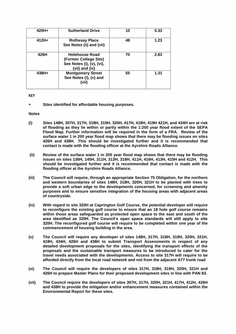
420H+ Sutherland Drive 10 0.33
412H+ Rothesay Place See Notes (ii) and (vii)
48 1.23
426H Holehouse Road (Former College Site) See Notes (i), (v), (vi),
(vii) and (ix)
70 2.83
438H+ Montgomery Street See Notes (i), (v) and
(vii)
55 1.31
KEY
+ Sites identified for affordable housing purposes. Notes (i) Sites 148H, 307H, 317H, 318H, 319H, 320H, 417H, 418H, 419H 421H, and 434H are at risk
of flooding as they lie within or partly within the 1:200 year flood extent of the SEPA Flood Map. Further information will be required in the form of a FRA. Review of the surface water 1 in 200 year flood map shows that there may be flooding issues on sites 426H and 438H. This should be investigated further and it is recommended that contact is made with the flooding officer at the Ayrshire Roads Alliance.
(ii) Review of the surface water 1 in 200 year flood map shows that there may be flooding
issues on sites 136H, 145H, 311H, 313H, 318H, 411H, 416H, 413H, 415H and 412H. This should be investigated further and it is recommended that contact is made with the flooding officer at the Ayrshire Roads Alliance.
(iii) The Council will require, through an appropriate Section 75 Obligation, for the northern
and western boundaries of sites 148H, 318H, 320H, 321H to be planted with trees to provide a soft urban edge to the developments concerned, for screening and amenity purposes and to ensure sensitive integration of the housing areas with adjacent areas of countryside.
(iv) With regard to site 320H at Caprington Golf Course, the potential developer will require
to reconfigure the existing golf course to ensure that an 18 hole golf course remains within those areas safeguarded as protected open space to the east and south of the area identified as 320H. The Council’s open space standards will still apply to site 320H. The reconfigured golf course will require to be completed within one year of the commencement of housing building in the area.
(v) The Council will require any developer of sites 148H, 317H, 318H, 319H, 320H, 321H,
418H, 434H, 426H and 438H to submit Transport Assessments in respect of any detailed development proposals for the sites, identifying the transport effects of the proposals and the sustainable transport measures to be introduced to cater for the travel needs associated with the developments. Access to site 317H will require to be afforded directly from the local road network and not from the adjacent A77 trunk road
(vi) The Council will require the developers of sites 317H, 318H, 319H, 320H, 321H and 426H to prepare Master Plans for their proposed development sites in line with PAN 83.
(vii) The Council require the developers of sites 307H, 317H, 320H, 321H, 417H, 412H, 426H
and 438H to provide the mitigation and/or enhancement measures contained within the Environmental Report for these sites.
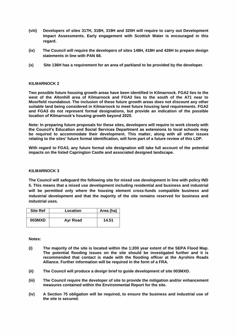
(viii) Developers of sites 317H, 318H, 319H and 320H will require to carry out Development
Impact Assessments. Early engagement with Scottish Water is encouraged in this
regard.
(ix) The Council will require the developers of sites 148H, 418H and 426H to prepare design
statements in line with PAN 68.
(x) Site 136H has a requirement for an area of parkland to be provided by the developer.
KILMARNOCK 2 Two possible future housing growth areas have been identified in Kilmarnock. FGA2 lies to the west of the Altonhill area of Kilmarnock and FGA3 lies to the south of the A71 near to Moorfield roundabout. The inclusion of these future growth areas does not discount any other suitable land being considered in Kilmarnock to meet future housing land requirements. FGA2 and FGA3 do not represent formal designations, but provide an indication of the possible location of Kilmarnock’s housing growth beyond 2025. Note: In preparing future proposals for these sites, developers will require to work closely with the Council’s Education and Social Services Department as extensions to local schools may be required to accommodate their development. This matter, along with all other issues relating to the sites’ future formal identification, will form part of a future review of this LDP. With regard to FGA3, any future formal site designation will take full account of the potential impacts on the listed Caprington Castle and associated designed landscape. KILMARNOCK 3
The Council will safeguard the following site for mixed use development in line with policy IND
5. This means that a mixed use development including residential and business and industrial
will be permitted only where the housing element cross-funds compatible business and
industrial development and that the majority of the site remains reserved for business and
industrial uses.
Site Ref Location Area (ha)
003MXD
Ayr Road 14.51
Notes:
(i) The majority of the site is located within the 1:200 year extent of the SEPA Flood Map. The potential flooding issues on the site should be investigated further and it is recommended that contact is made with the flooding officer at the Ayrshire Roads Alliance. Further information will be required in the form of a FRA.
(ii) The Council will produce a design brief to guide development of site 003MXD. (iii) The Council require the developer of site to provide the mitigation and/or enhancement
measures contained within the Environmental Report for the site. (iv) A Section 75 obligation will be required, to ensure the business and industrial use of
the site is secured.

(v) The Simon’s Burn forms a boundary of the site. This burn is a tributary of WB 10391 which is a UWWTD Sensitive Watercourse and so additional SUDs may be required to ensure that there is no increased risk of eutrophication.
KILMARNOCK 4 The Council will safeguard the following sites for continuing industrial use and as preferred areas to which new industrial and business development will be directed:
Site Ref
Location Area (ha)
152B Meiklewood/Mosside See Notes (i), (ii), (iii), (iv),
(v) and (vi)
43.28
153B Rowallan Business Park See Notes (ii), (viii) and
(xiii)
27.34
158B Moorfield (North) See notes (v), (vii) and (ix)
28.92
159B Moorfield (South) See notes (vii), (ix) and
(xiii)
20.55
322B Bonnyton Industrial Estate/West Langlands
Street
9.78
323B Glenfield Ind. Estate See note (x) and (xiv)
14.09
324B Glacier Vandervel See note (xi),(xii) and (xiii)
8.65
160B Moorfield Phase 3 See Notes (i), (ii), (iii), (iv),
(v), (vii), (ix) and (xiii)
18.84
Note: (i) Site 152B lies adjacent to the 1:200 year flood extent of the Fenwick Water and site
160B is at risk of flooding from minor watercourses. Further information in the form of an FRA is required. Review of the surface water 1 in 200 year flood map shows that there may be flooding issues on these sites. This should be investigated further and it is recommended that contact is made with the flooding officer at the Ayrshire Roads Alliance.
(ii) The Council will require any developer of the site 152B, 153B, and 160B to submit
Transport Assessments in respect of any detailed development proposals for the sites, identifying the transport effects of the proposals and the sustainable transport measures to be introduced to cater for the travel needs associated with the developments.
(iii) The Council will require the developers of sites 152B and 160B to prepare Master Plans
for their development in line with PAN 83.

(iv) The Council require the developers of sites 152B and 160B to provide the mitigation and/or enhancement measures contained within the Environmental Report for these sites.
(v) Early discussions with Scottish Water regarding Additional Trade Effluent Consents
will be required for major industrial developments which discharge to the Meadowhead PFI asset.
(vi) Foul effluent discharges to Meadowhead STW. Any further loading on this plant must
not result in an adverse impact on the Bathing Water at Irvine. (vii) The Moorfield Burn runs through the site. This is a tributary of the river Irvine, WB
10391. This is a UWWTD Sensitive Waterbody. Additional SUDS may be required to ensure that there is no increase in the risk eutrophication. The opportunity could be taken to de-culvert the Moorfield Burn.
(viii) The North Craigs Burn runs through the site. The burn channel should be maintained
and not be culverted. (ix) Site is close to the Billy Bowie waste site regulated by SEPA. (x) The River Irvine WB ID 20391disects this site. This is a UWWTD sensitive watercourse.
Additional SUDS may be required to ensure that there is no increased risk of eutrophication.
(xi) The River Irvine WB 10391 is adjacent to the site. This is a UWWTD Sensitive
watercourse. Additional SUDS may be required for any proposed surface water discharge to ensure that there is no increased risk of eutrophication.
(xii) This site is currently occupied by Mahle Engine Systems LTD which is regulated by
SEPA. (xiii) Potential flood risk from minor watercourses at site 324B. Further information in the
form of an FRA required. Review of the surface water 1 in 200 year flood map shows that there may be flooding issues on the site. This should be investigated further and it is recommended that contact is made with the flood prevention officer at the Ayrshire Roads Alliance.
(xiv) The site 323B is located within the 1:200 year flood extent for the River Irvine. Further
information in the form of an FRA is required. KILMARNOCK 5 A future industrial growth area has been identified to the east of Kilmarnock. FGA4 is situated in the vicinity of the Bellfield Interchange and is programmed to start post 2025. This does not currently constitute a formal site designation; rather it indicates where Kilmarnock’s future business and industrial expansion will take place. Note: In preparing future proposals for this site, developers will require to work closely with Transport Scotland to assess the impact of the development on the Bellfield Interchange and that satisfactory access can be taken from the A76 if this is required. This matter, along with all other issues relating to the sites’ future formal identification, will form part of a future review of this LDP.
KILMARNOCK 6 The Council will encourage and support the development of the following site as a neighbourhood centre suitable for small scale retail, a hotel/pub restaurant and community/recreational uses and public open space.
Site Ref Location Area (ha)
362M Southcraig Drive
2.30
Notes: (i) There is a potential risk of flooding from the minor watercourse. The watercourse also
appears to enter a culvert in close proximity to the site which may increase the risk of flooding to the site. It is also noted that the site is downstream of Northcraig reservoir and an adjoining covered reservoir. Further information in the form of an FRA required.
KILMARNOCK 7 The Council will encourage and support the development of the following site for leisure and recreational uses, for Class 4 (Office) uses or for the sale and display of motor vehicles:
Site Ref Location Area (ha)
163M Queen’s Drive (North)
5.61
Notes: (i) The Council will require any developer of the site to submit a Transport Assessment in
respect of any detailed development proposal for the site, identifying the transport effects of the proposal and the sustainable transport measures to be introduced to cater for the travel needs associated with the development.
(ii) There is a potential risk of flooding from the River Irvine. Further information in the
form of an FRA is required. Review of the surface water 1 in 200 year flood map shows that there may be flooding issues on the site. This should be investigated further and it is recommended that contact is made with the flood officer at Ayrshire Roads Alliance. Upstream is SFDAD scheme ID 15 Kilmarnock Flood Prevention Scheme. Downstream is Victoria Bridge and flood walls and embankments.
(iii) The Council require the developer of site to provide the mitigation and/or enhancement
measures contained within the Environmental Report for the site. (iv) The River Irvine WB 10391 forms the boundary of two sides of this site. This is a
UWWTD Sensitive Watercourse and so additional Sustainable Urban Drainage System (SUDS) may be required to ensure that there is no increased risk of eutrophication.

KILMARNOCK 8
The Council will encourage and support the redevelopment of the site for the erection of a
small scale neighbourhood centre. Permitted uses are Class 1, Class 2, Class 3 and hot food
uses:
Site Ref Location Area (ha)
232M Western Road
0.86
Note:
(i) Review of the surface water 1 in 200 year flood map shows that there may be flooding issues on the site. This should be investigated further and it is recommended that contact is made with the flooding officer at the Ayrshire Roads Alliance.
KILMARNOCK 9
The Council will encourage and support the redevelopment of the following sites for footfall generating uses and Class 4 (Business).
Site Ref
Location Area (ha)
326M Titchfield Street
0.92
Note: (i) The Council will require any developer of the site to submit a Transport Statement
setting out how the site can be satisfactorily accessed and serviced. (ii) The site lies within the 1:200 year flood extent of the SEPA Flood Map of the
Kilmarnock Water. Further information in the form of an FRA is required. (iii) The Council require the developer of site to provide the mitigation and/or enhancement
measures contained within the Environmental Report for the site. KILMARNOCK 10
The Council will encourage and support the redevelopment of the site for Class 1 retail use, Class 3 (Food and Drink), Class 4 (Business), Class 7 (Hotel and Hostels), Class 10 (Non-Residential Institutions) and Class 11 (Assembly and Leisure).
Site Ref
Location Area (ha)
327M West Shaw Street 2.67

Notes: (i) The Council will require any developer of the site to submit a Transport Assessment in
respect of any detailed development proposal for the site, identifying the transport effects of the proposal and the sustainable transport measures to be introduced to cater for the travel needs associated with the development.
(ii) The site lies within the 1:200 year flood extent of the SEPA flood map of the
Kilmarnock Water/River Irvine. Further information in the form of a Flood Risk Assessment required. Review of the surface water 1 in 200 year flood map shows that there may be flooding issues on the site. This should be investigated further and it is recommended that contact is made with the flooding officer at the Ayrshire Roads Alliance.
(iii) The Council require the developer of site to provide the mitigation and/or enhancement
measures contained within the Environmental Report for the site.
KILMARNOCK 11
The Council will encourage development of the site for residential, business and industry or leisure and cultural development.
Site Ref
Location Area (ha)
330M Balmoral Road 4.02
Notes: (i) The Council will require any developer of the site to submit a Transport Assessment in
respect of any detailed development proposal for the site, identifying the transport effects of the proposal and the sustainable transport measures to be introduced to cater for the travel needs associated with the development.
(ii) Review of the surface water 1 in 200 year flood map shows that there may be flooding
issues on the site. This should be investigated further and it is recommended that contact is made with the flooding officer at the Ayrshire Roads Alliance.
(iii) The Council require the developer of site to provide the mitigation and/or enhancement
measures contained within the Environmental Report for the site. KILMARNOCK 12 The Council will encourage and support retail use of the site but will consider redevelopment of the Retail Park, or part of the Retail Park, for other footfall generating or residential uses.
Site Ref
Location Area (ha)
370M Armour Street 0.88
Notes: (i) There is a potential risk of flooding from Kilmarnock Water on this site. Further
information in the form of an FRA required. Review of the surface water 1 in 200 year flood map shows that there may be flooding issues on the site. This should be investigated further and it is recommended that contact is made with the flooding officer at the Ayrshire Roads Alliance.
(ii) The Council require the developer of site to provide the mitigation and/or enhancement
measures contained within the Environmental Report for the site. KILMARNOCK 13
The Council will support and encourage the redevelopment of the site for educational,
community, business, leisure, food and drink and small scale retail use and for a care home,
crèche/nursery, public house and hotel.
Site Ref Location Area (ha)
371M Hill Street 10.89
Notes:
(i) Review of the surface water 1 in 200 year flood map shows that there may be flooding issues on the site. This should be investigated further and it is recommended that contact is made with the flooding officer at the Ayrshire Roads Alliance.
(ii) The Council will require any developer of the site to submit a Transport Assessment in
respect of any detailed development proposal for the site, identifying the transport effects of the proposal and the sustainable transport measures to be introduced to cater for the travel needs associated with the development.
(iii) The developer of the site will require to investigate the provision of a secondary
access onto Western Road. KILMARNOCK 14 The Council will support the redevelopment of the site for hotel, community or amenity uses.
The Council will not support retail uses at this location.
Site Ref
Location Area (ha)
372M Former Howard Park Hotel site, Glasgow
Road
0.39
Notes:
(i) The Council will require any developer of the site to submit a Transport Assessment in respect of any detailed development proposals for the site, identifying the transport
effects of the proposal and the sustainable transport measures to be introduced to cater for the travel needs associated with the development.
(ii) There is a potential risk of flooding from minor watercourse at the boundary of site.
Further information in the form of an FRA required. Review of the surface water 1 in 200 year flood map shows that there may be flooding issues on the site. This should be investigated further and it is recommended that contact is made with the flooding officer at the Ayrshire Roads Alliance.
(iii) The Council require the developer of site to provide the mitigation and/or enhancement
measures contained within the Environmental Report for the site.
KILMARNOCK 15 The Council will support the redevelopment of the site for footfall generating uses, Class 4 (business), community use and residential flats, where these are sensitive to neighbouring properties. Development will require to respect the listed building status of the properties and their conservation area setting.
Site Ref
Location Area (ha)
373M 30 – 38 John Finnie Street, 1 – 5 Dunlop Street and 12 Strand
Street
0.06
Notes: (i) The Council will require any developer of the site to submit a Transport Statement in
respect of any detailed development proposals for the site. Early contact with the Ayrshire Roads Alliance is advised in this regard.
(ii) The Council require the developer of site to provide the mitigation and/or enhancement
measures contained within the Environmental Report for the site. KILMARNOCK 16 The Council will encourage and support redevelopment of the site for residential, community, and footfall generating uses. Development will require to respect the listed status of the building.
Site Ref
Location Area (ha)
374M Former ABC Cinema, Titchfield Street
0.09

Notes: (i) The Council will require any developer of the site to submit a Transport Statement in
respect of any detailed development proposals for the site. Early contact with the Ayrshire Roads Alliance is advised in this regard.
(ii) There is a potential risk of flooding from the Kilmarnock Water on this site. Further
information in the form of an FRA required. Review of the surface water 1 in 200 year flood map shows that there may be flooding issues on the site. This should be investigated further and it is recommended that contact is made with the flooding officer at the Ayrshire Roads Alliance.
(iii) The Council require the developer of site to provide the mitigation and/or enhancement
measures contained within the Environmental Report for the site.
KILMARNOCK 17
The Council will encourage and support the development of the following sites for educational
purposes.
Site Ref
Location Area (ha)
384M Sutherland Drive See Note (i) (ii) and (iii)
7.13
385M Whatriggs Road See Note (i), (ii) and (iii)
2.43
Note: (i) The Council will require any developer of these sites to submit a Transport
Assessment in respect of any detailed development proposals, identifying the transport effects of the proposal and the sustainable transport measures to be introduced to cater for the travel needs associated with the development.
(ii) Sites 384M and 385M may be susceptible to flooding. Review of the surface water 1 in
200 year flood map shows that there may be flooding issues on the site. This should be investigated further and it is recommended that contact is made with the flooding officer at the Ayrshire Roads Alliance.
(iii) The Council require the developers of sites 384M and 385M to provide the mitigation
and/or enhancement measures contained within the Environmental Report for these sites.
KILMARNOCK 18
The Council will encourage and support the development of the following site for footfall
generating uses, housing and community/educational uses.
Site Ref
Location Area (ha)
386M Former Burlington Bertie’s, Braefoot
0.06

(i) The Council will require any developer of site 386M to submit a Transport Statement demonstrating that suitable access to the site can be achieved.
(ii) There is a potential risk of flooding from the Kilmarnock Water. Further information in the form of an FRA required. Review of the surface water 1 in 200 year flood map shows that there may be flooding issues on the site. This should be investigated further and it is recommended that contact is made with the flooding officer at the Ayrshire Roads Alliance.
(iii) The Council require the developer of the site to provide the mitigation and/or enhancement measures contained within the Environmental Report for the site.
KILMARNOCK 19 The Council will encourage and support the development of the following sites for housing and community and educational uses.
Site Ref
Location Area (ha)
387M Former St Columba’s PS, Elmbank Drive
See notes (i) and (ii)
0.31
389M Mount Pleasant Way/Hill Street
See note (i)
0.41
(i) The Council will require any developer of these sites to submit a Transport Assessment in respect of any detailed development proposals, identifying the transport effects of the proposal and the sustainable transport measures to be introduced to cater for the travel needs associated with the development.
(ii) Review of the surface water 1 in 200 year flood map shows that there may be flooding
issues on the site. This should be investigated further and it is recommended that contact is made with the flooding officer at the Ayrshire Roads Alliance.
KILMARNOCK 20
The Council will encourage and support the development of the following site for housing, a
petrol filling station or community uses.
Site Ref
Location Area (ha)
388M Wellington Street
0.18

Note:
(i) The Council require the developer to provide the mitigation and/or enhancement
measures contained within the Environmental Report for the site.
KILMARNOCK 21
The LDP safeguards the following sites for waste management purposes.
Site Ref
Location Area (ha)
002W Civic Amenity Site Western Road
3.15
003W Waste Transfer Station Southhook Road
0.73
004W Billy Bowie Moorfield Industrial
Estate
2.37
005W McGinns Metals EMR Burnside Street
0.3
PROP 15
The Council will encourage and support the implementation of the Kilmarnock placemaking
plans set out in Volume 1 of the LDP.
PROP 16 The Council will extend Kilmarnock Cemetery as shown on the Kilmarnock Local Development Plan Map. PROP 17 The Council will investigate the possibility of introducing new and enhanced rail park and ride car parks at appropriate locations in Kilmarnock and, in partnership with Strathclyde Partnership for Transport, will explore opportunities and identify land for a bus based park and ride facility at an interchange to the north west of Kilmarnock.

KILMAURS
Situated in the northern sub area and located approximately one kilometre to the north west
of Kilmarnock, Kilmaurs is an attractive settlement with a population of around 2,800 (in
2011). The town is focused around a well-preserved conservation area and offers a handful
of local services and community facilities.
The settlement hierarchy classifies Kilmaurs as a local centre. Due to its proximity to
Kilmarnock and its rail link to Glasgow and Kilmarnock, Kilmaurs is considered a suitable
location to meet local housing demand. Two sizeable greenfield housing sites are identified,
with a combined capacity of 230 houses. The allocation of these sites has avoided the south
eastern edge of Kilmaurs to avoid coalescence with Kilmarnock.
KILMAURS DEVELOPMENT OPPORTUNITIES
KILMAURS1 Residential development of the following sites will be supported by the Council:
Site Ref Location Capacity Area (ha)
305H Crosshouse Road West See Notes (i), (ii), (iii),
(iv) and (v)
140 9.22
422H Irvine Road See Notes (i), (iii), (iv)
and (v)
90 4.76
Note: (i) The Council will require any applications for development of sites 305H and 422H to be accompanied by Transport Assessments identifying the development’s transport effects and the sustainable transport measures proposed to cater for the travel needs associated with the development. (ii) A park and ride facility for Kilmaurs Rail Station will be required as part of any
development on site 305H. The size and exact location of this facility will require to be agreed with the Ayrshire Roads Alliance and will be the subject of an appropriate planning condition or Section 75 Obligation.
(iii) Sites 305H and 422H may be susceptible to flooding. Review of the surface water 1 in
200 year flood map shows that there may be flooding issues on the site. This should be investigated further and it is recommended that contact with the flooding officer at the Ayrshire Roads Alliance.
(iv) The Council will require the developer of sites 305H and 422H to prepare a design
statement in line with PAN 68.
(v) The Council require the developers of sites of 305H and 422H to provide the mitigation and/or enhancement measures contained within the Environmental Report for these sites.

KILMAURS PROPOSALS PROP 18 The Council will extend Kilmaurs Cemetery as shown on the Kilmaurs Local Development Plan Map.
KNOCKENTIBER
Located to the west of Kilmarnock within the northern sub area, Knockentiber is a small
predominantly residential settlement, with relatively few community or commercial facilities.
Knockentiber is identified as a local centre within the settlement hierarchy.
One small housing site is identified with capacity for 6 new houses, considered to represent
an appropriate small extension to the village. No further additional development is planned
for through the Plan.
KNOCKENTIBER DEVELOPMENT OPPORTUNITIES
KNOCKENTIBER 1 Residential development of the following sites will be supported by the Council:
Site Ref Location Capacity Area (ha)
423H Fisher Court
6 0.38

LEGGATE, CONNEL PARK AND BANK GLEN
These rural villages located to the west of New Cumnock are predominantly residential in
nature and comprise of small linear settlements that have developed along the B741.
Originally serving the local mining industry, the villages no longer have any industrial or
commercial premises.
Within Bank Glen a former school site is allocated as a miscellaneous development
opportunity site. The three villages may have capacity for additional small infill development,
where these will help to consolidate the settlements and develop brownfield sites, in line with
their rural village designations in the settlement hierarchy.
LEGGATE, CONNEL PARK AND BANK GLEN DEVELOPMENT OPPORTUNITIES LEGGATE, CONNEL PARK AND BANKGLEN 1 The Council will encourage redevelopment of the site for residential or community uses or for an appropriate business and industrial use which would not be detrimental to the amenity of nearby residential properties.
Site Ref
Location Area (ha)
030M Bank School
1.18
Note:
(i) Potential flood risk from minor watercourses adjacent to the eastern edge of the site. Review of the surface water 1 in 200 year flood map shows that there may be flooding issues on the site. This should be investigated further and it is recommended that contact is made with the flooding officer at the Ayrshire Roads Alliance. Further information in the form of an FRA is required.

LUGAR AND LOGAN
With a population of 1,260 in 2011, Logan comprises a large post war public sector housing
estate set within in a rural location to the east of Cumnock. Identified as a rural village within
the settlement hierarchy, Logan contains a small handful of shops, whilst the primary school
forms the key community facility. Logan has seen little demand for private development in
recent years which is considered unlikely to change over the LDP period. The plan does not
therefore identify any new development opportunity sites.
Lugar is a small, predominantly residential settlement located on the A70 to the north of
Logan. Much of the village is designated as a conservation area, based upon its industrial
archaeological heritage. Two residential opportunity sites are identified, both of which are
centrally located within the village and will consolidate the existing built form.
LOGAN & LUGAR DEVELOPMENT OPPORTUNITIES LUGAR1 Residential Development of the following sites will be supported by the Council:
Site Ref Location Capacity Area (ha)
424H Muirkirk Road
19 1.17
Notes: (i) Site 424H lies within the 1:200 year flood extent of the Lugar Water. Further information
required in the form of an FRA. LUGAR 2 The Council will encourage and support the development of Lugar for tourism purposes based on the association of the area with William Murdoch, the inventor of gas lighting.

LUGTON
Lugton is a small rural village within the northern part of East Ayrshire located on the
boundary with North Ayrshire. Aside from a public house, the settlement has no community
facilities or services, but is well linked by road to Dunlop and Stewarton.
The plan does not identify any development opportunities within Lugton. An area of
greenspace within the centre of the village is protected open space to help safeguard local
amenity.

MAUCHLINE
With a population of 4,105, Mauchline is an attractive settlement, strategically located on the
A76 trunk road, at its junction with the B731 to Ayr. Mauchline has a rich heritage linked to
Robert Burns and has considerable tourism potential, supported by the attractive
conservation area at the core of the town.
Mauchline is designated as a local centre in the settlement hierarchy and has an ample
existing supply of local shops and community facilities to meet local needs.
The plan identifies several sizeable residential opportunity sites within Mauchline, which
represent appropriate extensions to the housing stock within the town. The existing Station
Road industrial estate is safeguarded for continued industrial use, intended to support
continued commercial activity within the town.
MAUCHLINE DEVELOPMENT OPPORTUNITIES
MAUCHLINE1 Residential Development of the following sites will be supported by the Council:
Site Ref Location Capacity Area (ha)
335H Station Rd See Notes (i), (ii), (iii),
(iv) and (vi)
70 3.44
363H Corrie Mains Farm See Notes (i), (ii), (iii)
and (iv)
26 1.59
425H Kilmarnock Rd See Notes (iv), (v) and
(vi)
75 4.10
Note: (i) The developers of sites 335H and 363H will require to provide footpath linkages
between and through their sites. (ii) Sites 335H and 363H may be susceptible to flooding. Potential flood risk from minor
watercourse. Further information in the form of an FRA required. (iii) The Council will require the developer of sites 335H and 363H to carry out a Transport
Assessment in respect of the detailed development proposals for the site, identifying the transport effects of the proposal and the sustainable transport measures to be introduced to cater for the travel needs associated with the development.
(iv) The Council require the developers of sites 335H, 363H and 425H to provide the
mitigation and/or enhancement measures contained within the Environmental Report for these sites.

(v) Access to site 425H will require to be taken from the local road network and not directly from the A76 trunk road. Discussions with Transport Scotland may be required in this regard.
(vi) The Council will require the developers of sites 335H and 425H to prepare a design
statement in line with PAN 68.
MAUCHLINE 2 The Council will safeguard the following sites for continuing industrial use and as preferred areas to which new industrial and business development will be directed:
Site Ref
Location Area (ha)
042B Station Road Industrial Estate
1.63
MAUCHLINE PROPOSALS PROP 19 The Council will investigate the possibility of extending Mauchline Cemetery as shown on the Mauchline Local Development Plan Map. PROP 20 In recognition of peak time congestion at Mauchline Cross, the Council will, in partnership with relevant parties, investigate the potential funding mechanisms which could enable the construction of a by-pass for Mauchline.

MOSCOW
Moscow is a small village to the east of Kilmarnock which, apart from a commercial garage,
is entirely residential in nature. Identified as a rural village within the LDP settlement
hierarchy, Moscow does not contain any community facilities.
No development opportunities are being promoted through the plan for Moscow.

MUIRKIRK
Muirkirk is East Ayrshire’s eastern most settlement and is strategically located on the A70
which leads into neighbouring South Lanarkshire and on towards the M74. With a population
of 1,528 in 2011, Muirkirk comprises a traditional small town centre developed along
Smallburn Road and Main Street, as well as a large post war public sector housing estate
located at the western end of the village.
Muirkirk is served by a range of local shops and community facilities, including a local
primary school, library and games hall.
The former Muirkirk Bing site presents a major development opportunity site within the heart
of the village and is identified as a miscellaneous development opportunity site with potential
for a wide range of uses. The Furnace Road Industrial site is identified as a mixed use
opportunity, with potential for an element of residential use where this supports new
business and industrial development.
MUIRKIRK DEVELOPMENT OPPORTUNITIES MUIRKIRK 1 Residential Development of the following sites will be supported by the Council:
Site Ref
Location Capacity Area (ha)
044H Wellwood Street
See Notes (i), (iii) and (iv)
10 1.23
338H Smallburn Rd See Notes (ii)
and (iv)
8 0.36
Note (i) Site 044H may be susceptible to flooding. Review of the surface water 1 in 200 year
flood map shows that there may be flooding issues on the site. This should be investigated further and it is recommended that contact is made with the flooding officer at the Ayrshire Roads Alliance.
(ii) Site 338H is assumed to be greenfield and parts lie within the 1:200 year flood extent of
the SEPA Flood Map. A minor water course runs along the site boundary and may be culverted under site. Further information in the form of an FRA required.
(iii) The Council require the developer of site 044H to provide the mitigation and/or
enhancement measures contained within the Environmental Report for the site. (iv) The Council will require the developers of sites 044H and 338H to demonstrate that the
development will not have an adverse effect on the integrity of the Muirkirk and North
Lowther Uplands SPA.

MUIRKIRK 2
The Council will safeguard the following site for mixed use development including residential,
business and industrial. Residential development on this site will only be allowed where it
cross-funds compatible business and industrial development and that the majority of the site
is still reserved for business and industrial uses.
Site Ref Location Area (ha)
004MXD Furnace Road Industrial Site
4.24
Note (i) There is a potential flood risk from the River Ayr and Linky Burn. Further information
in the form of an FRA required. (ii) The Council will produce a design brief to guide development of site 004MXD. (iii) The Council require the developer of site to provide the mitigation and/or enhancement
measures contained within the Environmental Report for the site. (iv) The Council will require the developer of site to demonstrate that the development will
not have an adverse effect on the integrity of the Muirkirk and North Lowther Upland
SPA.
(v) A Section 75 obligation will be required, to ensure the business and industrial use of the site is secured.
(vi) The river Ayr WB 10421 and an unnamed tributary form boundaries of the site. MUIRKIRK 3 The Council will positively consider any sympathetic and realistic after-use of the site for residential, Class 4 (Business), recreational or amenity purposes, subject to ground conditions being proved suitable for such developments.
Site Ref
Location Area (ha)
051M Muirkirk Bing Site
10.33
Notes: (i) There is a potential flood risk from the River Irvine on this site. Site 051M is a
brownfield site and the majority of which is located within flood extent. Further information in the form of an FRA will be required.
(ii) Depending on the types of uses and scale of development, the Council may require the
developer of this site to carry out a Transport Assessment in respect of the detailed development proposals for the site, identifying the transport effects of the proposal and the sustainable transport measures to be introduced to cater for the travel needs associated with the development.

(iii) The Council require the developer of site to provide the mitigation and/or enhancement measures contained within the Environmental Report for the site.
(iv) The Council will require the developer of site to demonstrate that the development will
not have an adverse effect on the integrity of the Muirkirk and North Lowther Upland
SPA.
(v) The River Ayr WB 10421 forms one boundary of the site.
MUIRKIRK 4 The Council will encourage and support any proposal to redevelop the following site for an appropriate tourism, community or residential use:
Site Ref
Location Area (ha)
196M Former Nursery School, Main Street
0.22
Note:
(i) There is a potential flood risk from the River Ayr and minor watercourses to the southeast of the site. Further information in the form of a FRA required.
PROP 21 The Council will extend Muirkirk Cemetery as shown on the Muirkirk Local Development Plan map.

NEW CUMNOCK
New Cumnock developed as a linear settlement along the A76 trunk road south of Cumnock.
A large scale post-war public sector housing scheme to the south of the village centre has
seen substantial demolitions in recent years, contributing to the decline in population of
almost 10% since between 2001 and 2011. The population at 2011 was 2,860.
The village accommodates a range of local services, including a handful of shops, a primary
school and local library. A number of vacant buildings and sites on the A76 offer significant
potential to improve the physical appearance and vibrancy of the town. Options for improving
the area in the vicinity of the town hall, library, community centre and swimming pool are
being investigated and are likely to take place during the period of this LDP.
Several brownfield housing opportunity sites are identified as well as one greenfield site to
the north of the town. A miscellaneous development opportunity site is identified within the
town centre, on which the full range of footfall generating uses will be supported, as well as
residential or business and industry use.
NEW CUMNOCK DEVELOPMENT OPPORTUNITIES
NEW CUMNOCK1 Residential Development of the following site will be supported by the Council:
Site Ref Location Capacity Area (ha)
365H Mansfield Rd See Notes (i), (iv) and (v)
35 2.00
343H Crown Hotel See Note (ii)
26 0.28
429H Dalhanna Drive See Note (iii)
17 0.51
428H Castle See Note (iii)
5 0.14
Note: (i) There is a potential flood risk from minor water courses and Muirfoot Burn on site
365H. Further information in the form of an FRA is required. (ii) Site 343H is entirely within the 1:200 year fluvial extent of the SEPA Flood Map and will
result in an increase in vulnerability. Further information in the form of an FRA required.
(iii) Site 429H and 428H lies within and adjacent (respectively) to the 1:200 year flood
extent of the SEPA Flood Map. Further information in the form of an FRA required. (iv) The Council will require any developer of site 365H to submit a Transport Assessment
in respect of any detailed development proposals for the site, identifying the transport

effects of the proposal and the sustainable transport measures to be introduced to cater for the travel needs associated with the development.
(v) The Council require the developer of site 365H to provide the mitigation and/or
enhancement measures contained within the Environmental Report for the site. NEW CUMNOCK 2 The Council will safeguard the following site for continuing industrial use and as a preferred area to which new industrial and business development will be directed:
Site Ref
Location Area (ha)
345B Waterside Industrial Estate
1.21
Note: (i) Site 345B lies adjacent to the 1:200 year flood extent of the River Nith. Further
information required in the form of an FRA. NEW CUMNOCK 3 The Council will encourage and support any proposal to redevelop the site for appropriate community, residential, business or industrial use or for footfall generating uses, appropriate to the location of the site within the New Cumnock Town Centre:
Site Ref
Location Area (ha)
346M Castle
0.56
Notes: (i) The site lies within the 1:200 year flood extent of the SEPA Flood Map of the Afton
Water. Further information in the form of an FRA required. (ii) The Council require the developer of the site to provide the mitigation and/or
enhancement measures contained within the Environmental Report for the site. PROP 29 The Council will support the refurbishment of the town hall into a community hub and the development and implementation of environmental improvements to form a new community square in accord with the Community Action Plan encompassing the library, games hall, community centre and outdoor swimming pool.

NEWMILNS
Centrally located in the Irvine Valley, Newmilns is an attractive settlement with a population
of just over 3,000 in 2011. The town has two conservation areas, one of which benefitted
from significant physical improvements through the Townscape Heritage Initiative that was in
operation until May 2005.
The town is served by a range of local services and community facilities and is well linked to
neighbouring Galston, by road and local bus services, the hub service centre for the Irvine
Valley.
The plan safeguards the large industrial area along Brown Street, for continued and
expanded business and industrial use. Two brownfield residential opportunity sites are
identified, and two miscellaneous opportunity sites, supporting a range of community and
commercial uses.
NEWMILNS DEVELOPMENT OPPORTUNITIES NEWMILNS 1 Residential Development of the following sites will be supported by the Council:
Site Ref Location Capacity Area (ha)
430H Loudoun Road See Note (i)
10 0.27
431H Ladeside See Note (i)
5 0.46
Notes:
(i) 430H and 431H are both at risk of flooding from River Irvine. Further information in the form of an FRA required.
NEWMILNS 2 The Council will safeguard the following site for continuing industrial use and as a preferred area to which new industrial and business development will be directed:
Site Ref
Location Area (ha)
348B Brown Street See Notes (i), (ii) and
(iii)
11.06
Notes:
(i) There is a potential risk of flooding at Site 348B from minor watercourses. Further
information in the form of an FRA required. Review of the surface water 1 in 200 year
flood map shows that there may be flooding issues on the site. This should be
investigated further and it is recommended that contact is made with the flooding
officer at the Ayrshire Roads Alliance.

(ii) The Council will require any developer of site 348B to submit a Transport Statement
demonstrating that suitable access to the site can be achieved.
(iii) The river IrvineWB 10392 forms the boundary to the site and there are two small tributaries which are culverted through the site. The opportunity should be taken to de-culvert the small tributaries.
NEWMILNS 3 The Council will support and encourage the development of the site for community, tourism, leisure or recreational purposes.
Site Ref
Location Area (ha)
198M High Street
0.43
Notes:
(i) There is a potential risk of flooding from small watercourses adjacent to this site which
are culverted shortly downstream. Further information in the form of an FRA is required.
(ii) The Council require the developer of site to provide the mitigation and/or enhancement
measures contained within the Environmental Report for the site. NEWMILNS 4 The Council will support and encourage the development of the site for residential and Class 4, 5 and 6 business and industrial uses.
Site Ref
Location Area (ha)
381M Brown Street
0.51
Note:
(i) Site 381M lies within a 1:200 year flood extent of the SEPA Flood Map of the River Irvine. Further information is required in the form of a FRA. Review of the surface water 1 in 200 year flood map shows that there may be flooding issues on the site. This should be investigated further and it is recommended that contact is made with the flooding officer at the Ayrshire Roads Alliance.
(ii) The Council require the developer of site to provide the mitigation and/or enhancement
measures contained within the Environmental Report for the site. (iv) The River Irvine forms one boundary to the site.

OCHILTREE
Ochiltree is an attractive village located on the A70 a few miles to the west of Cumnock. The
central part of the town is designated as a conservation area and contains a significant
number of listed buildings. The village benefits from a small number of local shops and
community facilities.
Identified as a local centre within the LDP settlement hierarchy, the village has seen
significant growth in recent years, experiencing a 39% increase in population between 2001
(751) and 2011 (1,046).
Reflecting the significant level of private housing development that has taken place in
Ochiltree over the last 10 years, the plan does not promote any new development
opportunity sites within the village.

PATNA
Located on the A713 between Ayr and Dalmellington, Patna had a population of 2,206 in
2011 and is an example of a public sector housing estate located in an attractive rural
setting. The River Doon flows through the village and the associated large swathe of green
space surrounding the river, significantly adds to the attractiveness of the village.
Identified as a local centre, Patna is served by a small number of local services and
community facilities.
Several residential opportunity sites are designated, with one in particular providing a
significant sized opportunity for up to 160 houses. The Ayr Road industrial site is
safeguarded for continued and expanded industrial use to support the local economy.
PATNA DEVELOPMENT OPPORTUNITIES PATNA 1 Residential development of the following sites will be supported by the Council:
Site Ref Location Capacity Area (ha)
432H Main Street
6 0.14
350H Cemetery Road See Note (i)
6 0.19
351H Carskeogh Caravan Site See Note (ii)
160 11.45
435H Ayr Road See Note (iii) and (iv)
15 1.23
(i) Minor watercourse goes through the site 350H or along the site boundary. Review of
the surface water 1 in 200 year flood map shows that there may be flooding issues on the site. This should be investigated further and it is recommended that contact is made with the flooding officer at the Ayrshire Roads Alliance. Further information required in the form of an FRA.
(ii) The Council will require any developer of site 351H to submit a Transport Assessment
in respect of any detailed development proposals for the site, identifying the transport effects of the proposal and the sustainable transport measures to be introduced to cater for the travel needs associated with the development.
(iii) Site 435H lies adjacent to the 1:200 year flood extent of the River Doon. Further
information required in the form of a FRA. (iv) The Council require the developer of site 435H to provide the mitigation and/or
enhancement measures contained within the Environmental Report for the site.

PATNA 2 The Council will safeguard the following site for continuing industrial use and as a preferred area to which new industrial and business development will be directed:
Site Ref
Location Area (ha)
352B Ayr Road Industrial Site
11.06
Note: (i) Site 352B lies within the 1:200 year flood extent of the River Doon. Further information
required in the form of a FRA.

POLNESSAN
Polnessan is a small linear settlement to the north of Patna. Identified as a rural village
within the settlement hierarchy, Polnessan is entirely residential in nature, with no
community or commercial facilities.
No development opportunities sites are designated within Polnessan.

RANKINSTON
Identified in the LDP as a rural village, Rankinston is a small linear settlement in a rural
location to the south of Drongan. The village is in an elevated position and enjoys open
views of the surrounding countryside.
The village has limited community facilities aside from a community centre and playpark.
The plan identifies two residential opportunity sites within Rankinston, with a combined
capacity for 20 new houses, representing an appropriate extension to the existing housing
stock within the village.
RANKINSTON DEVELOPMENT OPPORTUNITIES RANKINSTON 1 Residential development of the following site will be supported by the Council:
Site Ref Location Capacity Area (ha)
341H Littlemill Place (1) See Notes (i) and (ii)
10 0.57
353H Littlemill Place (2) 10 0.11
(i) Site 341H lies adjacent to a 1:200 year fluvial extent. Further information in the form of a FRA is required.
(ii) The Council require the developer of site 341H to provide the mitigation and/or
enhancement measures contained within the Environmental Report for the site.

SINCLAIRSTON
Sinclairston is a small rural village, comprising of a small number of houses. Located to the
south west of Drongan, Sinclairston is identified as a rural village in the settlement hierarchy.
The village is entirely residential with no commercial or community facilities.
No further development is envisaged during the LDP period and no development opportunity
sites are therefore designated within Sinclairston.

SKARES
A small rural village located to the south west of Cumnock, Skares consists of a small
number of both traditional cottages and modern bungalows. A small play park provides the
only community facility for the village.
As no new development is envisaged within the LDP period, the plan does not promote any
new development opportunities within Skares.

SORN
Sorn is a picturesque village identified as a local centre in the settlement hierarchy, located
to the east of neighbouring Catrine. The village has two conservation areas, one centred on
the heart of the village and the other taking in Sorn Castle, an A listed building on the edge
of the settlement within an attractive landscape setting.
Sorn benefits from a small number of local services to meet local needs, including a post
office, primary school and village hall.
The plan identifies one residential opportunity site within the village, with capacity for
providing an additional 26 houses for the village; an appropriate extension to the existing
housing stock.
SORN DEVELOPMENT OPPORTUNITIES SORN 1
Site Ref Location Capacity Area (ha)
057H Catrine Road
26 2.05
Note: (i) The Council will require any developer of the site to submit a Transport Assessment in
respect of any detailed development proposals for the site, identifying the transport effects of the proposal and the sustainable transport measures to be introduced to cater for the travel needs associated with the development.
(ii) The Council require the developer of site to provide the mitigation and/or enhancement
measures contained within the Environmental Report for the site. (iii) There is a potential of flooding from minor watercourses on this site. Further
information in the form of an FRA required.
STEWARTON
With a population of approximately 7,000 in 2011, Stewarton is identified as a town for the
northern sub area of the LDP settlement hierarchy. Stewarton is well located in terms of
public transport, in particular the rail network, which has assisted in the town’s status as a
popular commuter location. The town benefits from an existing, well established and
attractive green network running through the town.
Stewarton is well served in terms of service provision, accommodating a high school, leisure
centre and a wide range of local convenience shops. Avenue Square within the town centre
is designated as a conservation area. In order to further protect and enhance the historical
qualities of the town centre, the LDP includes a proposal to extend the conservation area.
Recognising the attractiveness of Stewarton as a place to live and the associated demand
the town experiences, an appropriate scale of new residential development is planned for,
with three large sites greenfield sites identified for a total capacity of 390 houses, alongside
two small brownfield sites. Two sites close to the centre of the town are safeguarded for
continued industrial use and as preferred locations for new industrial development.
STEWARTON DEVELOPMENT OPPORTUNITIES STEWARTON 1
Residential development of the following sites will be supported by the Council:
Site Ref Location Capacity Area (ha)
354H Kilwinning Rd See Notes (ii), (iv), (v)
and (vi)
160 10.05
355H Draffen East See Notes (iii), (iv) and
(v)
150 8.84
356H Dunlop Road See Notes (i), (iv), (v) and
(vii)
130 7.59
439H Riverford See Note (i)
6 0.26
440H+ Robertland Square
8 0.35
Key + Sites identified for affordable housing purposes.

Notes: (i) There is a potential risk of flooding at Site 439H from the Annick Water. Further
information in the form of an FRA is required. (ii) There is a potential risk of flooding at Site 354H from minor watercourse through the
middle of the site. Further information in the form of an FRA is required. (iii) There is a potential risk of flooding at Site 355H from minor watercourses south of the
site. Further information in the form of an FRA is required. (iv) The Council will require any developer of Sites 354H, 355H and 356H to submit a
Transport Assessment in respect of any detailed development proposals for the site, identifying the transport effects of the proposal and the sustainable transport measures to be introduced to cater for the travel needs associated with the development.
(v) The Council will require the developers of site 355H and 356H to prepare design
statements in line with PAN 68.
(vi) The Council will require the developer of site 354H to enter into a Section 75 Agreement with the Council regarding the provision of upgraded footpath links along Kilwinning Road, particularly in the vicinity of the War Memorial.
(vii) The Council require any developer of site 356H to undertake, as appropriate, and NVC
Phase 1 Habitat Study to ensure that habitats and species are protected.
STEWARTON 2 An area of land to the west of Site 354H is identified as Future Growth Area 4 (FGA4) with development programmed to start post 2025. This site is not a formal site designation; rather it indicates where Stewarton’s future expansion will take place. The capacity of Stewarton Cross will be a key consideration in the identification of any site in a future review of the Local Development Plan. STEWARTON 3 The Council will safeguard the following sites for continuing industrial use and as a preferred area to which new industrial and business development will be directed:
Site Ref Location Area (ha)
192B Rigg Street See Note (i)
2.15
193B Bridgend See Note (ii)
0.83
Notes: (i) Review of the surface water 1 in 200 year flood map shows that there may be flooding
issues on the site 192B. This should be investigated further and it is recommended that contact is made with the flooding officer at the Ayrshire Roads Alliance.

(ii) Site 193B lies adjacent to the 1:200 year flood extent of the Annick Water. Further information required in the form of a FRA.
STEWARTON PROPOSALS PROP 23
The Council will encourage and support the implementation of the Stewarton placemaking
plan set out in Volume 1 of the LDP.
PROP 24 The Council will expand and re-designate the Stewarton Conservation Area as indicated on the Stewarton Proposals Map.
PROP 25 The Council will, subject to the necessary finance being available, prepare and implement an upgrading and improvement scheme for the B778 Fenwick to Stewarton Road.

WATERSIDE (BY FENWICK)
Waterside is an entirely residential settlement on the A719, north of Galston. Designated as
a rural village within the settlement hierarchy, the small settlement contains no retail or
community facilities.
A residential opportunity site has been identified with capacity for 16 units on the site of
existing agricultural buildings to the immediate west of existing houses within the village to
reflect a previous planning consent on the site.
WATERSIDE (BY FENWICK) Residential development of the following sites will be supported by the Council:
Site Ref Location Capacity Area (ha)
442H Arness Farm
16 1.18
Notes: (i) There is a potential risk of flooding from minor watercourses to the east of the site.
Further information in the form of an FRA is required.

Waterside (Doon Valley)
Waterside is a small rural village, situated on the A714 between Patna and Dalmellington.
The whole of the village is identified as a conservation area because of its industrial
archaeological importance, based on the former ironworks and brickworks that continue to
dominate the village. The former ironworks site is a scheduled monument and provides a
valuable resource with potential to develop for the tourist market.
No development opportunities sites are identified within Waterside.

RURAL AREA DEVELOPMENT OPPORTUNITIES RURAL AREA 1 The Council will support and encourage the sympathetic redevelopment of the following sites for leisure and recreational uses or for business, industrial or storage and distribution uses falling within Classes 4, 5 and 6 of the Use Classes Order:
Site Ref Location Area (ha)
058M Mauchline Colliery See Notes (ii), (v), (vi) and(vii)
21.40
059M Barony Power Station See Notes (iii) and (v)
9.94
060M Barony Colliery See Notes (i), (iv), (v) and (viii)
46.60
061M Skares Brickworks See Notes (iv) and (v)
1.80
Note: (i) Site 060M at Barony Colliery supports a substantial colony of Greyling Butterfly
Hipparchia Semele, a protected butterfly species. Appropriate steps will require to be taken in the preparation of any future development plans for the site to ensure that the proposed development will not adversely affect or compromise the nature conservation interest of the site.
(ii) There is a potential risk of flooding at Site 058M from the Cessnock Water and small
watercourses. Review of the surface water 1 in 200 year flood map shows that there may be flooding issues on the site. This should be investigated further and it is recommended that contact is made with the flooding officer at the Ayrshire Roads Alliance. Further information in the form of an FRA required.
(iii) There is a potential risk of flooding at site 059M from small watercourses. Review of
the surface water 1 in 200 year flood map shows that there may be flooding issues on the site. This should be investigated further and it is recommended that contact is made with the flooding officer. Further information in the form of an FRA is required.
(iv) There is a potential risk of flooding at site 060M from the Lugar Water/Glenmuir Water
and at site 061M from small watercourses. Review of the surface water 1 in 200 year flood map shows that there may be flooding on the site. This should be investigated further and recommended that contact is made with the flooding officer. Further information in the form of an FRA is required.
(v) The Council require the developers of sites 058M, 059M, 060M and 061M to provide the
mitigation and/or enhancement measures contained within the Environmental Report
for these sites.
(vi) Any developer of the site is required to undertake, where appropriate, an NVC Phase 1
Habitat Study to ensure that habitats and species are protected.
(vii) A Transport Statement must be submitted with any planning application for the site,
indicating the proposal and likely trips (numbers and types) to ensure that the local
road system is adequate for the nature of the development proposed.

(viii) The Lugar Water WB 10427 forms a boundary of the site. This is a UWWTD Sensitive
Watercourse. Additional SUDS may be required and the foul water drainage may
require additional treatment if a private treatment system were proposed. It would be
preferable if foul drainage was connected to the public foul sewers in Ochiltree. There
may be sewer and STW capacity issues if this were the case.
RURAL AREA 2 The Council will safeguard the following site for continued industrial use:
Site Ref Location Area (ha)
359B Egger Factory, Barony Road, Auchinleck
17.35
Note: (i) There is a potential risk of flooding from minor watercourses. Further information in
the form of an FRA is required. Review of the surface water 1 in 200 year flood map shows that there may be flooding issues on this site. This should be investigated further and it is recommended that contact is made with the flooding officer at the Ayrshire Roads Alliance.
RURAL AREA 3 The Council will encourage and support the development of the following area for hotel and leisure, recreational (golf) purposes.
Site Ref Location Area (ha)
193M
Rowallan Estate
126.35
Note: (i) The Council will require any developer of site 193M to submit a Transport Assessment
in respect of any detailed development proposals for the site, identifying the transport effects of the proposal and the sustainable transport measures to be introduced to cater for the travel needs associated with the development.
(ii) The Council will require the developer of site 193M to prepare a Master Plan for the site
in line with Supplementary Guidance on Master planning. This should be submitted to the Council prior to the submission of any formal planning application.
(iii) The site 193M lies within 1:200 year flood extent of the Carmel Water. Minor water
course within the site. Further information required in the form of a FRA. Review of the surface water 1 in 200 year flood map shows that there may be flooding issues on this site. This should be investigated further and it is recommended that contact is made with the flooding officer at the Ayrshire Roads Alliance.
(iv) The Council require the developer of the site to provide the mitigation and/or enhancement measures contained within the Environmental Report for the site.

RURAL AREA 4 The Council will encourage and support the development of the following area for further tourism and recreational development. The Council will be particularly supportive of holiday lodge and hotel development in the area or an appropriate scale of tourism based retail development catering for the needs of visitors to the area. Subject to the provisions of all other local plan policies or the provisions of any future master plan that may be agreed, the Council will be particularly supportive of sympathetic enabling development which would involve or contribute to the restoration or enhancement of Loudoun Castle itself and of its associated garden and grounds, or which would secure and enhance the function and viability of the Castle Estate as a major tourism destination.
Site Ref Location Area (ha)
366M Loudoun Castle and Estate, Galston
259.80
Note: (i) The Council will require a master plan approach to be adopted in respect of the future
tourism related development of the site. The master plan to be produced will be required to fully reflect and respect the provisions of the Council’s Supplementary Guidance on master planning and should be submitted to the Council for formal consideration prior to the lodgement of any associated planning applications with the planning authority.
(ii) Any proposed development in the area will be required to fully respect, in terms of its
size, scale, siting, design and material finish, the location of the area within the Loudoun Castle Historic Garden and Designed Landscape.
(iii) There is a potential risk of flooding on Site 366M from the River Irvine and several
small watercourses flowing through the site. Further information in the form of an FRA is required. Review of the surface water 1 in 200 year flood map shows that there may be flooding issues on the site. This should be investigated further and it is recommended that contact is made with the flooding officer at the Ayrshire Roads Alliance.
(iv) The Council will require any developer of site 366M to submit a Transport Assessment in respect of any detailed development proposals for the site, identifying the transport effects of the proposal and the sustainable transport measures to be introduced to cater for the travel needs associated with the development.
(v) The Council require the developer of the site to provide the mitigation and/or
enhancement measures contained within the Environmental Report for the site.
RURAL AREA 5 The LDP safeguards the following sites for waste management purposes:
Site Ref
Location
001W Dunniflats by Lugton
006W Milton Landfill, Kilmarnock
007W Gauchalland Roads Depot, Galston
009W Garlaff, Skares
PROP 26 The Council will work with relevant parties to implement a Long Distance Route from Darvel to Muirkirk which forms part of National Development 8 within National Planning Framework 3. Development of the long distance route should demonstrate to the Council that it will not have an adverse effect on the integrity of any Natura 2000 site PROP 27 The Council will work with Transport Scotland and others to investigate options for the future improvement of the Bellfield Interchange. PROP 28 The Council will investigate options for improving links from East Ayrshire to the M74 via the A71 and A70.

East Ayrshire Local Development Plan
Volume 2: Settlement Maps