Full Terms & Conditions of access and use can be found at http://www.tandfonline.com/action/journalInformation?journalCode=ueso20 Energy Sources, Part A: Recovery, Utilization, and Environmental Effects ISSN: 1556-7036 (Print) 1556-7230 (Online) Journal homepage: http://www.tandfonline.com/loi/ueso20 Economic geology value of oil shale deposits: Ethiopia (Tigray) and Jordan Yohannes Yihdego, Hilmi S. Salem, Bediaku G. Kafui & Zarko Veljkovic To cite this article: Yohannes Yihdego, Hilmi S. Salem, Bediaku G. Kafui & Zarko Veljkovic (2018): Economic geology value of oil shale deposits: Ethiopia (Tigray) and Jordan, Energy Sources, Part A: Recovery, Utilization, and Environmental Effects, DOI: 10.1080/15567036.2018.1488015 To link to this article: https://doi.org/10.1080/15567036.2018.1488015 Published online: 09 Jul 2018. Submit your article to this journal View Crossmark data
Transcript
Full Terms & Conditions of access and use can be found athttp://www.tandfonline.com/action/journalInformation?journalCode=ueso20
Energy Sources, Part A: Recovery, Utilization, andEnvironmental Effects
Economic geology value of oil shale deposits:Ethiopia (Tigray) and Jordan
Yohannes Yihdego, Hilmi S. Salem, Bediaku G. Kafui & Zarko Veljkovic
To cite this article: Yohannes Yihdego, Hilmi S. Salem, Bediaku G. Kafui & Zarko Veljkovic (2018):Economic geology value of oil shale deposits: Ethiopia (Tigray) and Jordan, Energy Sources, PartA: Recovery, Utilization, and Environmental Effects, DOI: 10.1080/15567036.2018.1488015
To link to this article: https://doi.org/10.1080/15567036.2018.1488015
Economic geology value of oil shale deposits: Ethiopia (Tigray) andJordanYohannes Yihdegoa, Hilmi S. Salemb, Bediaku G. Kafuic, and Zarko Veljkovicd
aGeotechnics and Tunnelling, Snowy Mountains Engineering Corporation (SMEC), Sydney, Australia; bResearch andDevelopment, Sustainable Development Research Institute, Bethlehem, Palestine (Occupied); cDepartment: MiningEngineering, University of Mines and Technology, Tarkwa, Ghana; dGeotechnics and hydrogeology, GeologicalSurvey of Serbia, Belgrade, Serbia
ABSTRACTOil shale is an organic-rich, fine-grained sedimentary rock, containing kerogen,from which liquid hydrocarbons (called shale oil) can be produced. The oil shaledeposits in the Tigray region are found in the northern parts of Ethiopia, EasternAfrica. They are of Upper Paleozoic in age, existing as remnants of theCretaceous erosion period, underlain by tillites and overlain by sandstones.They were formed during the glacial retreat followed by marine deposition ofshales in a basin created by the enormous load of the glaciers. The Ethiopian-Tigray oil shale deposits cover an area extending over approximately 30 km2,with an average mineable bed-thickness of 55 m, showing on the upper partinter-beds and laminations of shaley limestones. The oil shale resources in thisregion are estimated to be approximately 4 billion tonnes. The exploitation ofthe Ethiopian-Tigray oil shale deposits is an excellent alternative to fulfill the fueland other petroleumproducts’ demandof Ethiopia. This study sheds light on theoil shale resources in the Ethiopian region of Tigray, as they are fairly investi-gated, regarding their geological characterization, and future strategies for theirexploration and exploitation potential. In addition, the oil shale deposits inJordan are also moderately investigated, as Jordan is considered a promisingcountry for shale oil, taking into account that Jordan has no other hydrocarbonresources (such as crude oil and natural gas), unlike many other countries in theMENA (Middle East and North Africa) region, as MENA sets on “seas” of oil andnatural gas. Furthermore, oil shale in the USA is also briefly investigated, as theUSA is being the world’s largest country of oil shale resources and reserves. Also,some other issues related to the oil shale industry are investigated, such aseconomics, extraction technologies of shale oil, and the environmental impacts.
KEYWORDSEl-Lajjun; ethiopian-tigrayregion; geology; Jordan;Kerogen; Mining; oil shale;Reserves; Total OrganicContent (TOC); USA
Introduction
The terms of “oil shale” and “shale oil”
The terms “oil shale” for the rock, and “shale oil” for the retorted product (also known as “LightTight Oil” (LTO)) have been well-understood for more than one hundred years now. Both terms (oilshale and shale oil) have been consistently applied to the fine-grained, organic-rich sedimentary rockthat contains solid organic matter, from which a liquid hydrocarbon (shale oil) can be extractedwhen the rock is heated in the chemical process of pyrolysis, either on the surface or at depth. Mostof the organic matter in the source rock (oil shale) is in the form of kerogen, which is insoluble inordinary organic solvents, and some of the organic matter in the source rock is bitumen that issoluble in organic solvents (Dyni 2003).
Oil shale was formed millions of years ago by deposition of silt and organic debris on lake beds andsea bottoms. Temperature and pressure transformed, over long geological periods of time, thematerials into oil shale in a process similar to the process that forms the petroleum, but at lesspressures and lower temperatures. Oil shale can be mined and processed to generate oil similar to oilpumped from conventional oil wells. However, extracting shale oil from oil shale is more complex and,thus, more expensive than recovering the conventional oil. This is mainly because the oil substances(shale oil) in the oil shale are solid and, thus, cannot be pumped directly out of the ground.Accordingly, the oil shale must first be mined and then heated at high temperatures (350–450°Cand up to 500–600°C), through a process called “retorting”, and the resultant liquid must then beseparated and collected. An alternative, but currently experimental process, is referred to as “in-situretorting”, which involves heating the oil shale while it is still underground, and then pumping theresulting liquid to the surface.
Worldwide reserves of oil shale
As a source rock for most conventional oil reservoirs, oil shale deposits are found in many regionsaround the world, although most of the deposits are too deep to be exploited, economically. Thereare more than 600 known oil shale deposits around the world. Although resources of oil shale occurin many countries, only 33 countries possess known deposits of possible economic values. More thanhalf of the identified oil shale resources are found in the USA, Russia, China, Argentina, Libya,Algeria, Canada, and Mexico (WEC 2016).
The largest recent estimates put the USA’s shale oil at 6 trillion barrel (bbl), China is second at330 billion bbl, Russia third at 270 billion bbl, Israel (Historical Palestine) fourth at 250 billion bbl,and Jordan and the Democratic Republic of Congo tied for fifth at approximately 100 billion bbl,each. Estonia, which is on the way to become the largest producer of shale oil, soon, is currently 11th
with only 16 billion bbl (WEC (World Energy Council) 2016). It is noteworthy to mention that theunit of volume for crude oil and other petroleum products is “barrel” (bbl). One bbl equals 42 USgallons or 35 UK (imperial) gallons, or approximately 159 liters, or 5.6 cubic feet; and 6.29 bbl equalone cubic meter (m3), and 7.33 bbl weigh one metric ton (1,000 kg).
Some estimates set the total world’s resources of oil shale at around 689 gigatons (gigatonnes),which is equivalent to a yield of 4.8–5.0 trillion barrels (760–790 billion cubic meters (BCM)) ofshale oil, of which 1.0–1.32 trillion barrels (160–210 BCM) of shale oil may be technically recover-able, as of January 2007 (Dyni 2010; IEA 2010). A 2016-estimate sets the total world’s resources ofshale oil equivalent to yield of 6.05 trillion bbl (962 BCM) (WEC (World Energy Council) 2016). Atthe same time, for comparison, the world’s proven crude oil (petroleum) reserves are estimated to be1.6976 trillion bbl (269.90 BCM) (WEC (World Energy Council) 2016), constituting approximately28% of the world’s shale oil reserves (if considered 962 BCM).
USA: the world’s largest oil shale reserves
The largest resource deposits of oil shale exist in the USA, which are thought to contain 3.7 trillionbarrels (590 BCM) of shale oil, forming about 75%–80% of the world’s shale oil’s potential, thoughonly a part of it is recoverable (Dyni 2010). The USA’s oil shale resources are mainly found, inaddition to other locations (Table 1), in the Green River’s Formation (Table 1), covering portions ofColorado, Utah, and Wyoming, with oil-resources’ estimates of 1.2–1.8 trillion barrels (Bartis et al.2005). However, even a moderate estimate (800 billion barrels of recoverable shale oil from oil shalein the Green River’s Formation) is three times greater than the proven oil reserves in Saudi Arabia(Bartis et al. 2005). The present USA’s demand for petroleum products is about 20 million barrelsper day. If the shale oil could be used to meet a quarter of the USA’s demand, then the estimated 800billion barrels of recoverable shale oil from the oil shale of the Green River’s Formation would lastfor more than 400 years (Bartis et al. 2005).
2 Y. YIHDEGO ET AL.
Recoverable oil shale reserves
The term “oil shale resources” may refer to all of the oil shale deposits that contain kerogen. On theother hand, the term “oil shale reserves” refers to the amount of “oil shale resources”, which aretechnically exploitable and economically feasible under current economic conditions. Table 2 showsthe reserves by estimated amounts of shale oil in some regions and countries around the world.
The shale oil extraction technologies are still developing, so the amount of recoverable kerogencan only be estimated. Oil shale deposits range from small presently economically recoverablereserves to large presently uneconomically recoverable resources (Kilian 2016; Niu et al. 2013;
Table 1. The world’s largest oil shale deposits (after Dyni 2006).
Deposit Country Geological Age
In-situ Oil ShaleResources
(106 metric tons*)
In-situ Shale OilResources(106 barrels)
Green River’s Formation USA Paleogene 213,000 1,466,000Phosphoria Formation USA Permian 35,775 250,000Eastern Devonian USA Devonian 27,000 189,000Heath Formation USA Early
ENERGY SOURCES, PART A: RECOVERY, UTILIZATION, AND ENVIRONMENTAL EFFECTS 3
Potapov 2016; Raukas and Punning 2009). However, defining oil shale reserves is difficult, becausethey vary considerably, in terms of their different chemical composition, and their kerogen content,as well as their extraction technologies.
Many oil shale deposits need more exploration to determine their potential as reserves. Well-explored deposits, which could ultimately be classified as reserves, include the Green RiverFormation’s deposits in the western parts of the USA; the Tertiary deposits in Queensland,Australia; the deposits in Sweden and Estonia; and the El-Lajjun (Al-Lajjun) deposits in Jordan; aswell as some other deposits in France, Germany, Brazil, China, and Russia. It is expected that thesedeposits would yield at least 40 liters (0.25 bbl) of shale oil per metric ton of oil shale, using theFischer Assay (Dyni 2006). The oil shale is converted into shale oil by assuming oil content of 100liters or 0.09 tons of oil per a ton of shale (Lechtenböhmer et al. 2011).
Technologies used to extract shale oil from oil shale
Shale oil refers to synthetic oil obtained by heating the organic material (kerogen) contained in theoil shale to a temperature, which will separate it into oil, combustible gas, and the residual carbonthat remains in the spent shale rock. The kerogen’s content of oil shale deposits differs widely, andthe economic feasibility of its extraction is highly dependent on international and local costs of theconventional hydrocarbons (crude oil and natural gas) (Yihdego and Al-Weshah 2016a, 2016b). Thismeans that if the price of crude oil per barrel is higher than the production price of shale oil perbarrel, then the extraction of shale oil is economic, and if the price of crude oil per barrel is less thanthe production price of shale oil per barrel, then the extraction of shale oil is uneconomic.
Several methods are used to determine the quantity and quality of the products extracted from oilshales (Tao et al. 2016, 2013, 2012b, 2012c, 2012a). At their best, these methods give an approximatevalue to its energy potential. One standard method is the “Fischer Assay”, which yields a heating value–that is a measure of caloric output. This is generally considered a good overall-measure of usefulness. The“Fischer Assay” method has been modified, standardized, and adapted by the American PetroleumInstitute (API). It does not, however, indicate howmuch oil could be extracted from a sample of oil shale.Some processing methods yield considerably more useful product than the “Fischer Assay” methodwould yield. The “Tosco II”method yields over 100%more oil than the “Fischer Assay”, and the “Hytort”process yields between 300% and 400% more oil than the “Fischer Assay” (Dyni 2006).
Environmental impacts of oil shale industry
Unlike renewable energy sources (Yihdego, Salem, and Pudza 2017), the issue of the environmentalimpacts of the oil shale industry is one of the main factors influencing the development of the industryitself. Many countries have paid much attention and, thus, they developed different effective pollution-control technologies to reduce the environmental impacts resulted from the oil shale industry. The oilshale industry includesmining, crushing, sieving, retorting, combustion, and oil upgrading, which lead tomany environmental impacts. These impacts include environmental pollution (such as wastewaterproduced from mining, retorting, upgrading, ash moisturing, etc.); dust (produced from mining,crushing, sieving, retorting, and combustion); oil sludge; shale ash, retorted shale handling, and disposal;waste gas from retorting and combustion; and land disruption due to surface mining (Lechtenböhmeret al. 2011; Raukas and Punning 2009; Wan 2009; Yihdego and Paffard 2017).
The environmental impacts of the oil shale industry include, particularly, wastewater discharge,groundwater contamination, air pollution, and shale-ash disposal (Yihdego and Al-Weshah 2016c).Wastewater discharged from a retorting oil shale industrial plant contains oil and suspension solids, aswell as oxygen-, nitrogen-, and sulfur-compounds, which can be treated by sedimentation, oil intercep-tion, flocculation, air floatation, and biological treatment (Yihdego andAl-Weshah 2017). Air pollution ismainly due to the fly-ash, sulfur dioxide, and nitrogen oxides contained in the flue gas leaving thechimneys of the oil shale boilers in the power plant. High efficiency dust remover, and high efficiency
4 Y. YIHDEGO ET AL.
sulfur dioxide absorber or adsorber should be used, and, thus, adequate technologies should be applied forlower emissions of the nitrogen oxides. Shale ash formed from oil-shale power plants and oil-shaleretorting plants may be used for mine backfilling, for agricultural utilization, and for cement making(Tao et al. 2010, 2011, 2012a, 2017).
Ethiopia’s oil shale potential
Ethiopia has the misfortune of being entirely landlocked as a result of the 30-year war with itsneighboring country–Eritrea (Figure 1). Still, oil and gas exploration in Ethiopia is advancing muchfaster. Ethiopia has less potential and has no offshore prospects, which should make it less attractivethan Eritrea which is neighboring the Red Sea (Figure 1), but foreign oil and gas companies favor it,nonetheless. Ethiopia has considerable resources of oil shale deposits, which are found in variouslocations (Figure 1).
The Ethiopian oil shale is dominated by long-chain aliphatic hydrocarbons, and it has lowsulphur content. It also includes high total organic content (TOC), amounting up to 55%–60%(Tadesse 2015). So, according to the Schlumberger’s definition of TOC (Table 3), the Ethiopian oilshale deposits (with TOC up to 55%–60%) can be classified as “excellent”, in terms of the oil shale’sTOC and its kerogen’s quality (Table 3).
Figure 1. Map of the locations of oil shale deposits in Ethiopia (after Tadesse 2015).
Table 3. Total organic content (TOC) of oil shale source rocks (afterSchlumberger 2017).
Total Organic Content (TOC) (%) Oil Shale Kerogen’s Quality
< 0.5 Very Poor0.5–1.0 Poor1.0–2.0 Fair2.0–4.0 Good4.0–12.0 Very Good> 12.0 Excellent
ENERGY SOURCES, PART A: RECOVERY, UTILIZATION, AND ENVIRONMENTAL EFFECTS 5
The TOC values indicate the possibility of kerogen filling the pore spaces of oil shale rather thanother forms of hydrocarbons. The TOC is measured from 1-g samples of pulverized rock that arecombusted and converted to CO or CO2. If a sample of oil shale appears to contain sufficient TOC toextract shale oil from it, the sample then may be subjected to pyrolysis. This can successfully beapplied on the Ethiopian oil shale deposits, as they have high TOC (55%–60%).
Some oil shale deposits found in the west and south-west parts of Ethiopia, as well as the north-east central parts of Ethiopia occur in thick shale formations (400–800 m thick). Palynologicalstudies confirmed that these deposits (found in W, SW, and NE central parts of Ethiopia) are ofEocene, Miocene, and Oligocene ages (Tadesse 2015). A total of about 653 million tons to one billiontons of oil shale reserves have been estimated in these regions (Ahmad 2008). Other studies indicatethat Ethiopia has an estimated 3.89 billion tons of oil shale (enough to produce about one trillionbarrels of shale oil) in the Tigray State alone (more details given below), located on the border withEritrea (Tigrai Online 2013), which is of Upper Paleozoic to Mesozoic ages.
The Ethiopian Delbi-Moye basin (Figure 1) is a small rift basin, preserving a thick sedimentarysuccession of Eocene to Miocene age. Much of the area is covered by the Ashangie thick volcanicgroup, and within it coal and oil shale-bearing strata are enclosed. The oil shale (in addition to coal)exploration has been conducted in the Geba basin. The coal and oil shale- bearing sedimentary strataof this basin are found intercalated within the Tertiary volcanic rocks, similar to other deposits inother parts of the country. Although up to 25-m thick oil shale is found in the Geba basin, theresource is not evaluated (GSE 2016). The oil shale, found in the south-western parts of the country,occurs between the Lake Ziway and the Lake Abyiata in the valleys of the Bulbul River and itstributaries. The inter-trappean fluviatile-lacustrine oil shale-bearing sediments are widely distributedon the south-western Plateau of Ethiopia in the Delbi-Moye, Lalo-Sapo, Sola, Gojeb-Chida, Mojo-Anchema, and Yayu basins (Ahmad 2008). Recent drilling data has proved the presence of 120million tons of oil shale deposits at the Delbi-Moye basin (Figure 1), while no details are known forthe Bulbul River deposits (GSE (Geological Survey of Ethiopia) 2016).
Oil shale in tigray, northern ethiopia
As indicated above, Ethiopia has a great potential of oil shale resources in most parts of the Country.The Tigray region, located in the north most part of the country, has, in particular, huge deposits ofoil shale (Figure 2). The Tigray region is covered by the sedimentary succession of Upper Paleozoicto Mesozoic age, forming parts of the Edaga Arbi Formation, and is exposed as erosion remnants ofcliffs that found underlain unconformably by the Basement of Proterozoic Upper Complex meta-morphic rocks (Table 4). The Basement (named Upper Complex) has been folded but subjected toonly the lowest grades of metamorphism, mainly of green-schist facies (Jembere and Yihdego 2016).It includes the Tsaliet Group, the Tembien Group, the Didikama Formation, and the MatheosFormation (Beyth 1971; Garland 1980). The Tembien Group, the Didikama Formation, and theMatheos Formation are meta-sediments, in contrast to the Tsaliet Group which is mainly of meta-volcanics (Garland 1980; Sembroni et al. 2017).
After the peneplanation of the continental land surface in the Lower-Middle Paleozoic, clasticdeposition began, probably during the Upper Paleozoic (Garland 1980), and this whole succession isresting unconformably on the Precambrian rocks (Table 4). This succession consists of threeformations, named Enticho Sandstone, Edaga Arbi Glacials, and Adigrat Sandstone (Blanford1970; Dow, Beyth, and Tsegaye 1971; Garland 1980; Sembroni et al. 2016). The Enticho SandstoneFormation and Edaga Arabi Glacials can be observed underneath the Basement.
The Enticho Sandstone Formation is composed of a white medium-grained quartzite, without orwith coarse cross-bedding, which grades to siltstones and then to friable black shales of the EdagaArbi Glacials. The Glacial Unit consists of calcareous tillites, which is poorly sorted fragments of
6 Y. YIHDEGO ET AL.
quartz supported pebbles of meta-volcanic, rounded granite, and boulders of gneissic rocks. TheGlacial Unit grades to the deposition of friable shales, which make-up the greatest thickness of theglacials. The thick shale deposition is the potential oil shale resource in the Ethiopian Tigray region.
The probable sequence of events to the Edaga Arbi Glacials and the Enticho Sandstone Formationis explained by Garland (1980) and Bussert and Schrank (2007) as following: 1) Deposition ofsandstone in continental fluviatile and subaerial environment; 2) Glacial age begins, meaning out-wash from glaciers formed coarse sandstone channeled by migrating braided streams; 3) Afterreduction of relief, the following occurred: A small rise in sea level, a change to a warmer climate,
Figure 2. Location map and potential of oil shale deposits in the Tigray region, northern Ethiopia (after Girmay 2006). For details(zoomed in), see Figure 3.
Table 4. A summarized stratigraphy of the Tigray region, northern Ethiopia (after Garland 1980; Mohr 1963).
Age* Rock Unit Composition Description Physiography
*Based on the relative age estimation of Mohr (1963) and Garland (1980).
ENERGY SOURCES, PART A: RECOVERY, UTILIZATION, AND ENVIRONMENTAL EFFECTS 7
and deposition in very quiet lacustrine or shallow marine conditions; 4) Return of glacial conditions(deposition of moraine); 5) Gradual retreat of glaciers with rising sea level; and 6) Generally marinedeposition of shale with some fresh water periods, forming thin limestones and varves.
The age of oil shale from the Edaga Arbi Glacials has been dated as Devonian or younger(Garland 1980) (Table 4). The uppermost unit of the clastic sequence (named Adigrat Sandstone)rests with undulating unconformity on the Edaga Arbi Glacials (shale) and on the EntichoSandstone. The Adigrat Sandstone is yellowish to pink fine to medium grained, non-calcareousquartz sandstone with well-sorted rounded grains; it is cross-bedded and current-bedded (Garland1980) and is estimated to be deposited during the Upper Triassic to Middle Jurassic (Table 4)(Enkurie 2010; Garland 1980; Mohr 1963).
These clastic successions are observed grading to the Antalo succession in the region, whichconsists of Antalo Limestone and Agula Shale. The Antalo Limestone is conformable on the AdigratSandstone and is estimated to be formed during Upper Jurassic, which consists of limestone andmarl sequences. The Agula Shale, which includes limestone, shale, gypsum, and dolomite, appearsmore shaly and gypsiferous. These formations mainly cover the Mekelle basin and have beeninvestigated for the probability of existence of petroleum resource (Bosellini et al. 1997).
Geological characteristics of the tigray’s oil shales
The oil shale deposits in the Tigray region (northern Ethiopia) are widely spreading under theAdigrat Sandstone, which covers a large portion of the region (Bussert and Schrank 2007; Enkurie2010), and is found exposed covering a large area at Bizet, Edga Arbi, Nebelet, and Atebe (Table 5;Figure 2; Figure 3; Figure 4).
Economic evaluation of the ethiopian oil shale deposits
Ethiopia is a poor country on which each cent counts in its economic development (Yihdego andKwadwo 2017). The country is dependent on agricultural and livestock products to earn hardcurrency. Ethiopia is a sole importer of fuels and fuel products. Estimates indicate that half of itshard currency is spent to fulfill the country’s fuels’ demand. Ethiopia has no any well-known
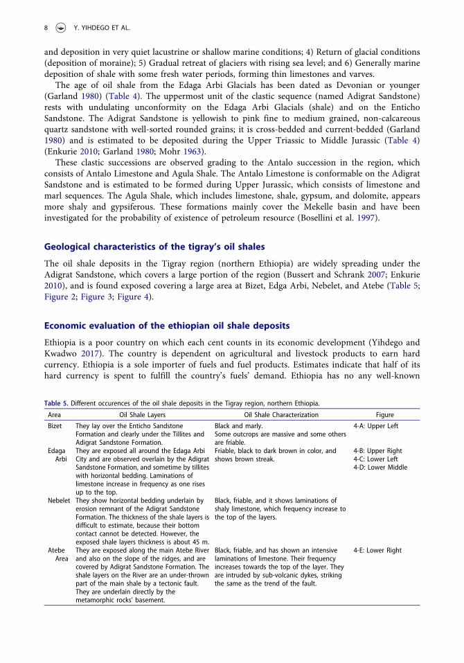
Table 5. Different occurences of the oil shale deposits in the Tigray region, northern Ethiopia.
Area Oil Shale Layers Oil Shale Characterization Figure
Bizet They lay over the Enticho SandstoneFormation and clearly under the Tillites andAdigrat Sandstone Formation.
Black and marly.Some outcrops are massive and some othersare friable.
4-A: Upper Left
EdagaArbi
They are exposed all around the Edaga ArbiCity and are observed overlain by the AdigratSandstone Formation, and sometime by tilliteswith horizontal bedding. Laminations oflimestone increase in frequency as one risesup to the top.
Friable, black to dark brown in color, andshows brown streak.
4-B: Upper Right4-C: Lower Left4-D: Lower Middle
Nebelet They show horizontal bedding underlain byerosion remnant of the Adigrat SandstoneFormation. The thickness of the shale layers isdifficult to estimate, because their bottomcontact cannot be detected. However, theexposed shale layers thickness is about 45 m.
Black, friable, and it shows laminations ofshaly limestone, which frequency increase tothe top of the layers.
AtebeArea
They are exposed along the main Atebe Riverand also on the slope of the ridges, and arecovered by Adigrat Sandstone Formation. Theshale layers on the River are an under-thrownpart of the main shale by a tectonic fault.They are underlain directly by themetamorphic rocks’ basement.
Black, friable, and has shown an intensivelaminations of limestone. Their frequencyincreases towards the top of the layer. Theyare intruded by sub-volcanic dykes, strikingthe same as the trend of the fault.
4-E: Lower Right
8 Y. YIHDEGO ET AL.
Zala Ambesa E
Bizet ShaleAdigrat
AdwaAxum
Enticho Nebelet Shale
Werei LekeEdaga Arbi Shale Hawzein
Atebe Shale
Figure 3. Location and area coverage estimates of the oil shale occurrences of the Tigray region, northern Ethiopia (afterGirmay 2006).
Figure 4. A) Upper Left: Oil shale layers at Bizet overlying the Enticho Sandstone Formation and underlying the Adigrat SandstoneFormation; B) Upper Right: Oil shale at Edaga Arbi, overlain by the Adigrat Sandstone Formation and showing laminations of shalylimestone (increasing its frequency towards the top); C) Lower Left: Regular fractures trending N30°W, dipping 80°E and N70°E,dipping 75°NW on the Edaga Arbi Shale Formation; D) Lower Middle: Oil shale overlain by the Adigrat Sandstone Formation andpartly covered by landslide debris of sandstone; E) Lower Right: Oil shale layers exposed on the bank of Atebe River, showingbed-mark of fault, trending N30°W and dipping 80°E (after Girmay 2006).
ENERGY SOURCES, PART A: RECOVERY, UTILIZATION, AND ENVIRONMENTAL EFFECTS 9
conventional petroleum resources. However, it is blessed with extensive oil shale occurrences all overthe territory of the country. Therefore, the only way to support the country’s economy is to search analternative approach by reducing hard currency expenses on imported fuels, which can be reached bydeveloping its oil shale industry through producing the shale oil from the oil shale deposits.
The Ethiopian Government needs to give attention and commence to exploration to discover oilshale deposits without any delay to support its need of hard currency. The oil shale occurrences inEthiopia have been known since the mid-1950s, and investigations have been done at the WolloProvince in the northern parts of the country. The laboratory results of sample analyses during thattime proved that the oil shale deposits contain at least 6% petroleum volatiles (Astrup 1956).According to recent studies (Tadesse 2015), the oil shale deposits found in different parts ofEthiopia include up to 55%– 60% TOC (as discussed above).
The quick survey done to discover oil shale in the Tigray region (northern Ethiopia) found veryvast area coverage of shale overlain by the Adigrat Sandstone Formation. Most of the oil shaledeposits in the Tigray region are covered by weathered floats of debris of sandstone, which areexposed at Bizet, Edaga Arbi, Nebelet, and Atebe. Potentially, there may be still many otherundiscovered exposures in the region, in particular, and in the country, at large.
The estimation of the oil shale resources in the Tigray region was calculated based on theoutcrops exposed on the surface and their area coverage of the overlying sandstones. Althoughthese oil shale deposits have horizontal bedding, and are unconformably overlain by the AdigratSandstone Formation, they disappear at places or have thin beds (up to 10 m) like in the Adigratarea, where a thick succession of sandstone occurs. Such disappearance occurs on places of highlandsand the shale thickness increases on the rims of Werri glacial basin.
The Werri glacial basin is surrounded by rims of peaks of sedimentary ridges and currently iscovered by exposed basement rocks due to erosion. The oil shale deposits are found exposed on theslope of these rims of sedimentary ridges. Thus, to calculate the real potential of these oil shaledeposits requires detailed exploration works, because the area coverage of the sandstone is extremelyvast in the region. Based on the observations in each area of the four areas mentioned above(Figure 2; Figure 3; Figure4), the oil shale deposits are estimated to cover an area of: 1) Bizet oilshale = 2.65 km2; 2) Edaga Arbi oil shale = 21.11 km2; Nebelet oil shale = 4.18 km2; and 4) Atebe oilshale = 2.44 km2, which all cover, in total, an area of 30.38 km2. Based on the observations, theaverage possible mineable bed thickness (exposed thickness) is about 55 m. Therefore, the oil shaleresource of the observed area in the Tigray region is estimated at 3.89 billion tons.
The Geological Survey of Ethiopia (GSE) has also conducted many exploration projects for oilshale discoveries in different parts of the country. The projects were successful in identifying manyoccurrences, and some of them have given a kerogen’s value of 120 liter/ton. This value may be takenas a theoretical threshold for oil shale to be considered as an energy input. The limiting kerogen’scontent is a function of many parameters, but the lower quoted value is 5% organic content, whichcorresponds to an oil yield of 25 liter/ton of rock or 6 US gallons/ton (Ekinci 1995).
Jordan: a good example on oil shale in the MENA region
As related to the oil shale resources in theMENAregion (Middle East andNorthAfrica,where huge reservesof crude oil and natural gas exist), Jordan is considered a poor country in terms of crude oil and natural gas,but it is rich with respect to shale oil, representing a good example on the oil shale in theMENA region. TheJordanian oil shale deposits are of high quality, comparable to the USA’s oil shale deposits. They have TOCvalues ranging from approximately 18% to 23% weight (Table 6), and, thus, they can be classified as“excellent” (as demonstrated in Table 3), in terms of the oil shale kerogen’s quality, according toShclumberger (2017). However, the Jordanian oil shale in some locations has a high content of sulfur(8%–10%) (Alali et al. 2015), while in some other locations the sulfur content is relatively low, ranging from0.3 to 4.3% (Dyni 2006). According to various estimates, the oil shale deposits in Jordan underlie more than
10 Y. YIHDEGO ET AL.
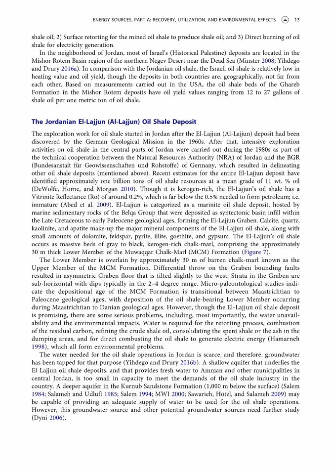
60% of the Jordanian territory, totaling approximately 40–70 billion tons. Some other estimates reach up to100 billion tons of oil shale (as indicated above), whichwouldmake Jordanone of the richest countries in theworld, with respect to the oil shale deposits. Oil shale is widely distributed in Jordan and can be identified infew outcrops and mostly in the subsurface (see Figure 5).
Themost important oil shale occurs in the lower part of the Upper CretaceousMuwaqqar Chalk-Marl(MCM) Formation, which outcrops across much of the central northern and central southern parts ofJordan. Although the oil shale in Jordan is widely spreading, it varies in thickness and in oil content. TheJordanian most significant oil shale deposits are found in more than 25 locations around the country;with the 8 most important deposits located in the central region of the country (see Table 6). TheJordanian best-explored oil shale deposits (Table 6; Figure 6) were found in the following regions:El-Lajjun (Al-Lajjun), Sultani, Jurf Ed-Darawish, Attarat Um El-Ghudran, Wadi Maghar, Wadi Thamad(Eth-Thamad), Khan Ez-Zabib, and Siwaga (Siwaqa). The oil shale deposits in these 8 locations exist inthe west-central parts of Jordan (Figure 6), meanwhile the oil shale deposits in the Yarmouk region arefound in the Yarmouk River’s region in northern Jordan, which is close to the Jordanian-Syrian borders,extending into the Syrian Territory (Figure 6).
The Jordanian oil shale deposits are kerogen-rich, bituminous, argillaceous limestones, depositedin shallow marine during the Late Cretaceous to early Tertiary (Maastrichtian-Danian) geologicalages (Hussein 2013; Hussein et al. 2015; MEMR 2017). The origin of the kerogen is the dead plantsand animals that found in the ancient seas and lakes during the Upper Cretaceous geological agesand after the burial process, along with high temperatures and pressures, which caused the changefrom organic matter to kerogen.
The Jordanian oil shale was not investigated thoroughly, as there has been only little interest indeveloping such resources during the 1980s and 1990s, when relatively low prices for crude oil on the
Table 6. Resource data for 8 deposits of oil shale in Jordan (after Jaber, Probert, and Badr 1997; Hamarneh 1998; Dyne 2006;Alali et al. 2015).
Figure 5. Some pictures of the oil shale deposits and the extracted shale oil in Jordan (MEMR (Ministry of Energy and MineralResources) 2017).
ENERGY SOURCES, PART A: RECOVERY, UTILIZATION, AND ENVIRONMENTAL EFFECTS 11
international market prevailed, which discouraged entrepreneurs from making investments in the oilshale industry (Jaber, Amri, and Ibrahim 2011). In 2006, this situation changed due to many factors,including, most importantly, the growing bill for imported energy. Thus, the Jordanian Governmenttook the initiative to develop the oil shale industry by attracting international developers and experiencedcompanies to work in this field.
The energy strategy of the Jordanian Government aims to increase the contribution of oil shalesources to 10% by 2025, while reducing the imported energy (crude oil and natural gas) resources.However, Jordan has lately (in September 2016) signed a historic 15-year, 10 billion USD gas’ deal withIsrael to purchase 45 billion cubic meters (BCM) of gas from the Leviathan field in theMediterranean Sea(TTOI 2016).
The oil shale exploitation in Jordan, with the support of international investors and technologies(from, for instance, the USA, Canada, China, Germany, Malaysia, Estonia, Saudi Arabia, Russia,Brazil, etc.), is considered a long-term strategic goal in meeting the Jordanian energy demands fromindigenous resources. The Government of Jordan, through the Ministry of Energy and MineralResources (MEMR), is currently engaged with a three-track approach to deal with the oil shaledevelopment in the country, which includes: 1) In-situ exploration for deep oil shale to produce
Figure 6. Location map of the major oil shale deposits in Jordan (after Alali et al. 2015).
12 Y. YIHDEGO ET AL.
shale oil; 2) Surface retorting for the mined oil shale to produce shale oil; and 3) Direct burning of oilshale for electricity generation.
In the neighborhood of Jordan, most of Israel’s (Historical Palestine) deposits are located in theMishor Rotem Basin region of the northern Negev Desert near the Dead Sea (Minster 2008; Yihdegoand Drury 2016a). In comparison with the Jordanian oil shale, the Israeli oil shale is relatively low inheating value and oil yield, though the deposits in both countries are, geographically, not far fromeach other. Based on measurements carried out in the USA, the oil shale beds of the GharebFormation in the Mishor Rotem deposits have oil yield values ranging from 12 to 27 gallons ofshale oil per one metric ton of oil shale.
The Jordanian El-Lajjun (Al-Lajjun) Oil Shale Deposit
The exploration work for oil shale started in Jordan after the El-Lajjun (Al-Lajjun) deposit had beendiscovered by the German Geological Mission in the 1960s. After that, intensive explorationactivities on oil shale in the central parts of Jordan were carried out during the 1980s as part ofthe technical cooperation between the Natural Resources Authority (NRA) of Jordan and the BGR(Bundesanstalt für Geowissenschaften und Rohstoffe) of Germany, which resulted in delineatingother oil shale deposits (mentioned above). Recent estimates for the entire El-Lajjun deposit haveidentified approximately one billion tons of oil shale resources at a mean grade of 11 wt. % oil(DeWolfe, Horne, and Morgan 2010). Though it is kerogen-rich, the El-Lajjun’s oil shale has aVitrinite Reflectance (Ro) of around 0.2%, which is far below the 0.5% needed to form petroleum; i.e.immature (Abed et al. 2009). El-Lajjun is categorized as a marinite oil shale deposit, hosted bymarine sedimentary rocks of the Belqa Group that were deposited as syntectonic basin infill withinthe Late Cretaceous to early Paleocene geological ages, forming the El-Lajjun Graben. Calcite, quartz,kaolinite, and apatite make-up the major mineral components of the El-Lajjun oil shale, along withsmall amounts of dolomite, feldspar, pyrite, illite, goethite, and gypsum. The El-Lajjun’s oil shaleoccurs as massive beds of gray to black, kerogen-rich chalk-marl, comprising the approximately30 m thick Lower Member of the Muwaqqar Chalk-Marl (MCM) Formation (Figure 7).
The Lower Member is overlain by approximately 30 m of barren chalk-marl known as theUpper Member of the MCM Formation. Differential throw on the Graben bounding faultsresulted in asymmetric Graben floor that is tilted slightly to the west. Strata in the Graben aresub-horizontal with dips typically in the 2–4 degree range. Micro-paleontological studies indi-cate the depositional age of the MCM Formation is transitional between Maastrichtian toPaleocene geological ages, with deposition of the oil shale-bearing Lower Member occurringduring Maastrichtian to Danian geological ages. However, though the El-Lajjun oil shale depositis promising, there are some serious problems, including, most importantly, the water unavail-ability and the environmental impacts. Water is required for the retorting process, combustionof the residual carbon, refining the crude shale oil, consolidating the spent shale or the ash in thedumping areas, and for direct combusting the oil shale to generate electric energy (Hamarneh1998), which all form environmental problems.
The water needed for the oil shale operations in Jordan is scarce, and therefore, groundwaterhas been tapped for that purpose (Yihdego and Drury 2016b). A shallow aquifer that underlies theEl-Lajjun oil shale deposits, and that provides fresh water to Amman and other municipalities incentral Jordan, is too small in capacity to meet the demands of the oil shale industry in thecountry. A deeper aquifer in the Kurnub Sandstone Formation (1,000 m below the surface) (Salem1984; Salameh and Udluft 1985; Salem 1994; MWI 2000; Sawarieh, Hötzl, and Salameh 2009) maybe capable of providing an adequate supply of water to be used for the oil shale operations.However, this groundwater source and other potential groundwater sources need further study(Dyni 2006).
ENERGY SOURCES, PART A: RECOVERY, UTILIZATION, AND ENVIRONMENTAL EFFECTS 13
Discussion and conclusions
Oil shale is a type of sedimentary rock that is rich in the organic matter, named “kerogen”. Thissubstance is not liquid petroleum, but organic matter formed from prehistoric marine plants andanimals. Kerogen is converted into oil (shale oil) when heated long enough and at high temperatures.
While oil shale is found in many countries of the world, the USA has the largest reserves found inthe Green River’s Formation in Colorado, Utah, and Wyoming. The USA’s shale oil estimates areroughly up to 5 trillion barrels, of which 1.0–1.3 trillion barrels are recoverable. Even if only 800billion barrels can actually be recovered, this is still three times greater than the 262.6 billion barrelsin Saudi Arabia’s oil reserves. According to some estimates, the USA’s oil shale reserves could supplyAmerican oil needs (about 20 million barrels a day) for 400 years.
Regarding Ethiopia, though this country has considerable resources and reserves of oil shale, thereis currently a lack of interest in exploring them, possibly due to the disputes over the area betweenEthiopia and Eritrea, which led to unresolved conflicts between both countries. An estimatedamount of 3.89 billion tons of oil shale will produce roughly about one trillion barrels of shale oil,which is considered a huge amount of oil, if it is successfully extracted. Thus, this amount of shale oilwill not only satisfy the Ethiopian local market, but it will also have some left for export, earningmuch needed hard currency.
Geologically speaking, the oil shale in the Ethiopian Tigray region is found sparingly distributedunder the Adigrat Sandstone Formation all over the erosion remnant of the sedimentary chainridges. It is formed during the glacial retreat followed by marine deposition of shale in the Werriglacial basin created by enormous load of the glaciers. It is black, friable, having brown streak, and
Figure 7. Oil shale outcrop of El-Lajjun (Al-Lajjun) deposit, showing, from top to bottom, beds of gravel, chalk-marl, chalk, slightlybituminized marly limestone, and oil shale with gray color (Left); and El-Lajjun’s local geology (stratigrahic vertical column) (Right)(after DeWolfe 2010; Alali et al. 2015).
14 Y. YIHDEGO ET AL.
laminations of shaly limestone which their frequencies increase to the top of the shale formation.This is an evidence of frequent and continuous deposition of the oil shales in different environ-mental conditions. The oil shale formation has been displaced by tectonic faults, which causedclosely spaced regular fractures, trending towards N300W, and dipping 800E, N700E, and 750NW.The oil shale formation is also intruded by sub-volcanic dykes, trending the same trend as the faultstowards N300W, and dipping 800E.
Though the kerogen’s value of the Ethiopian Tigray’s oil shale deposits is not yet analyzed, thegeological characteristics of the oil shales and the amount of resource in the Tigray region show thatit is possible to be mined by in-situ retorting underground method. However, the resource isexposed and it will be more economical if mining is conducted by open-cast. The by-product ashcan be used in many industrial purposes by the Ethiopian Government, companies, and/or by thelocal people of the area.
Regarding Jordan (as being one of the richest countries in the MENA region, with respect to oilshale resource, while it lacks crude oil and natural gas resources), it has significant oil shale depositsoccurring in more than 25 known localities. Geological surveys indicate that the existing depositsunderlie more than 60% of the Jordanian territory. The resource has been estimated to consist of40–70 billion tons of oil shale, which may be equivalent to more than 5 million tons of shale oil.Some estimates of the oil shale in Jordan reach up to 100 million tons. Accordingly, the JordanianGovernment has already launched a long-term energy strategy (2007–2020), in which the shale oil(extracted from the oil shale resource in the country) has been given considerable attention as a goodJordanian energy source (Sahawneh 2015).
In their study on the challenging geology of the oil shale deposits in Jordan, Puura, Soesoo, andAosaar (2016) pointed out that the oil shale layers, subjected to sub-surface oxidation, show distinctlithological, mineralogical, and chemical characterizations, especially trace-elements’ patterns. Thepresence of mineralogical and geochemical trace elements in oxygenated primary oil shale depositsprovides key information for the local and regional paleo-tectonic, paleo-hydro(geo)logical, and paleo-climatic investigations. This key information could be used together with micro-paleontological andstratigraphic studies for the detailed mapping and understanding of the oil shale deposits in the variouslocations in Jordan.
In brief, the geology value of the oil shale deposits in Ethiopia and Jordan (as two poor developingcountries, with respect to oil and natural gas resources) can be translated into considerable andrewarding economic values that will greatly benefit the gross domestic product (GDP) of bothcountries. However, the environmental impacts of the oil shale industry, as well as its need for hugeamounts of water required for the industrial operations of the oil shale should be seriously taken intoconsideration by the industrialists, environmentalists, hydrogeologists, engineers, and the policy-and decision-makers, who are concerned of this industry.
References
Abed, A. M., K. Arouri, B. S. Amiereh, and Z. Al-Hawari. 2009. Characterization and genesis of some Jordanian oilshales. Dirasat, Pure Sciences 36(1):7–17.
Ahmad, W. 2008. Fossil fuel energy resources of Ethiopia. Bulletin of Chemical Society of Ethiopia 22(1):67–84.Alali, J., A. Abu Salah, S. M. Yasin, and W. Al Omari. 2015. Oil shale. In Ministry of energy and mineral resources,
Sahawneh, J. and M. Madanat. (Eds.). Amman, Jordan: Mineral Status and Future Opportunity.Astrup, J. (1956). Report on an oil shale occurrence in Wollo Province. Unpublished report on file at the Ministry of
Mines and Energy, Addis Ababa, Ethiopia.Bartis, J. T., T. LaTourrette, L. Dixon, D. J. Peterson, and G. Cecchine (2005). Oil shale development in the United
States prospects and policy issues. Rand corporation, MG-414-NETL. Rand Infrastructure, Safety, and Environment.Rand Corporation, Santa Monica, CA, USA.
Beyth, M. (1971). The geology of central and western Tigray. Unpublished manuscript on file at the Ministry of Minesand Energy, Addis Ababa, Ethiopia.
ENERGY SOURCES, PART A: RECOVERY, UTILIZATION, AND ENVIRONMENTAL EFFECTS 15
Blanford, W. T. 1970. Observations on the geology and zoology of abyssinia. London: MacMillan.Bosellini, A., A. Russo, P. L. Fantozzi, G. Assefa, and S. Tadesse. 1997. The Mesozoic succession of the Mekelle Outlier
(Tigrai region, Ethiopia).Memoirs of the National Science Museum (Tokyo) Sciences Géologiques - Memoires 49:95–116.Bussert, R., and E. Schrank. 2007. Palynological evidence for a latest Carboniferous–Early Permian glaciation in
Northern Ethiopia. Journal of African Earth Sciences 49:201–10.DeWolfe, J. C., E. J. Horne, and C. A. Morgan (2010). Geology and geochemistry of the Al Lajjun oil shale deposit,
Central Jordan. Search and Discovery Article #50366. Adapted from oral presentation at AAPG Conference andExhibition, Calgary, Alberta, Canada, 12–15 September.
Dow, D. B., M. Beyth, and H. Tsegaye. 1971. Palaeozoic glacial rocks recently discovered in Northern Ethiopia.Geological Magazine 108:53–59.
Dyni, J. R. 2003. Geology and resources of some world oil-shale deposits. Oil Shale 20(3):193–252.Dyni, J. R. (2006). Geology and Resources of Some World Oil-Shale Deposits. Scientific Investigations Report 2005-5294.
U.S. Department of the Interior, U.S. Geological Survey, Virginia, USA.Dyni, J. R. 2010. Oil Shale. In 2010 survey of energy resources, Eds. Clarke, A. W. and J. A. Trinnaman, 93–123. 22nd
ed., London, UK: World Energy Council.Ekinci, E. 1995. Economic considerations of the oil shale and related conversion processes. In Composition, Geochemistry
and Conversion of Oil Shales. NATO ASI Series C: Mathematical and Physical Sciences, Snape, E. C., Ed., Vol. 455.Dodrecht: Springer.
Enkurie, D. L. (2010). Adigrat Sandstone in Northern and Central Ethiopia: Stratigraphy, Facies, DepositionalEnvironments and Palynology. Ph.D. Dissertation, University of Berlin, Berlin, Germany.
Garland, C. R. (1980). Geology of the Adigrat Area. Memoir No.1, Ministry of Mines, Addis Ababa, Ethiopia.Girmay, D. (2006). Geological characteristics and economic evaluation of oil shale deposits in Tigray, Ethiopia. 26th
Oil Shale Symposium, Colorado School of Mines, 16-19 October.GSE (Geological Survey of Ethiopia) (2016). Hydrocarbon Resources. http://www.gse.gov.et/index.php/2016/09/03/
hydrocarbon-resources/ http://www.memr.gov.jo/Pages/viewpage.aspx?pageID=202Hamarneh, Y. (1998). Oil shale resources development in Jordan. Natural Resources Authority, Amman, Hashemite
Kingdom of Jordan, 98 p.Hussein, M. A. A. (2013). Sedimentology of Cretaceous–Paleogene Oil Shales from Jordan. Ph.D. Dissertation, Ruhr
Universitaet Bochum (RUB), Bochum, Germany, December, 128 p.Hussein, M. A. A., M. Alqudah, M. Blessenohl, G. Olaf, O. G. Podlaha, and J. Mutterlose. 2015. Depositional
environment of Late Cretaceous to Eocene organic-rich marls from Jordan. GeoArabia 20(1):191–210.IEA (International Energy Agency). 2010. World Energy Outlook 2010. Paris: OECD. ISBN 978-92-64-08624-1Jaber, J. O., A. Amri, and K. Ibrahim. 2011. Experimental investigation of effects of oil shale composition on its
calorific value and oil yield. International Journal of Oil, Gas and Coal Technology 4(4):307–21.Jaber, J. O., S. D. Probert, and O. Badr. 1997. Prospects for the exploitation of Jordanian oil shale. Oil Shale 14:565–78.Jembere, D., and Y. Yihdego. 2016. Engineering rock mass evaluation for a multi-purpose hydroelectric power plant:
Case of Genale Dawa (GD-3), Ethiopia. Journal of Geotechnical and Geological Engineering 34(5):1593–612.Kilian, L. 2016. The impact of the shale oil revolution on U.S. oil and gasoline prices. Review of Environmental
Economics and Policy 10(2):185–205.Lechtenböhmer, S., M. Altmann, S. Capito, Z. Matra, W. Weindrorf, and W. Zittel (2011). Impacts of shale gas and
shale oil extraction on the environment and on human health. European Parliament, Directorate-General forInternal Policies. Policy Department, Economic and Scientific Policy. IP/A/ENVI/ST/2011-07. PE 464.425.Brussels, Belgium.
MEMR (Ministry of Energy and Mineral Resources) (2017). Petroleum and Oil Shale Projects. Petroleum ExplorationBlocks in Jordan. MEMR, Amman, Jordan.
Minster, T. (2008). Oil shale deposits in Israel. Geological Survey of Israel. https://web.archive.org/web/20081124201154/http://www.mni.gov.il/NR/rdonlyres/78558E7B-2068-443E-8AFA-B2BA7864F935/0/OilShaleDesposits.pdf
Mohr, P. A. 1963. Occurrence of Karoo system sediments in Ethiopia. Nature 199:1086.MWI (Ministry of Water and Irrigation) (2000). Water Resource Policy Support. Groundwater Management
Component. Outline Hydrogeology of the Amman-Zarqa Basin, (May), 13 p. The Water Resource PolicySupport activity is supported by the United States Agency for International Development (USAID) through acontract with Associates in Rural Development Inc. (ARD): USAID/ARD Contract No. LAG-I-00-99-00018-00.
Niu, M., S. Wang, X. Han, and X. Jiang. 2013. Yield and characteristics of shale oil from the retorting of oil shale andfine oil-shale ash mixtures. Applied Energy 111:234–39.
Potapov, O. P. 2016. Experience and prospects of oil shale utilization for power production in Russia. ThermalEngineering 63(9):643–47.
Puura, V., A. Soesoo, and H. Aosaar (2016). Challenging oil shale geology of Central Jordan. The 3rd JordanInternational Oil Shale Symposium (3rd JIOSS) and the 36th CSM Symposium, 21-22 November, Amman,Jordan. https://www.researchgate.net/publication/311102380_Challenging_oil_shale_geology_of_Central_Jordan
Raukas, A., and J. Punning. 2009. Environmental problems in the Estonian oil shale industry. Energy and EnvironmentalScience 2:723–28.
Sahawneh, J. (2015). Energy Policy: Country Report/Jordan. Planning and International Cooperation Directorate/Investment Division. Ministry of Energy and Mineral Resources, Amman, Jordan. Power Point Presentation, Japan,2 June. http://eneken.ieej.or.jp/data/6206.pdf
Salameh, E., and P. Udluft. 1985. The hydrodynamic pattern of the Central Part of Jordan. Geologisches JahrbuchC38:39–58. (Hannover, Germany).
Salem, H. S. (1984). Hydrology and Hydrogeology of the Area North of Zerqa River, Jordan. Master Thesis, Universityof Jordan, Amman, Jordan, 162 p.
Salem, H. S. (1994). A budget of the surface- and underground water in Northern Jordan. A paper presented at theInternational Academic Conference on “Water in the Middle East”, held at the Swiss Federal Institute ofTechnology (ETH), Zurich, Switzerland, 10-13 December 1992, pp: 135–62. In: J. Isaac and H. Shuval (Eds.),“Water and Peace in the Middle East (Proceedings of the International Academic Conference on Water in the MiddleEast)”, Studies in Environmental Science, 58, Elsevier, Amsterdam, the Netherlands, 529 p.
Sawarieh, A., H. Hötzl, and E. Salameh. 2009. Aquifers in the Eastern Jordan Valley. In The Water of the Jordan Valley,Hötzl, H., P. Möller, and E. Rosenthal. Eds., 361–70. Berlin-Heidelberg, Germany: Springer.
Schlumberger (2017). Oilfield Glossary: TOC: Geology, Shale Gas. http://www.glossary.oilfield.slb.com/Terms/t/toc.aspxSembroni, A., P. Molin, F. Dramis, and B. Abebe. 2017. Geology of the Tekeze River Basin (Northern Ethiopia).
Journal of Maps 13(2):621–31.Sembroni, A., P. Molin, F. J. Pazzaglia, C. Faccenna, and B. Abebe. 2016. Evolution of continental-scale drainage in
response to mantle dynamics and surface processes: An example from the Ethiopian Highlands. Geomorphology261:12–29.
Tadesse, K. (2015). Petroleum Licensing in Ethiopia: Current activities and opportunities. UNCTAD. 17th Africa OilGas Mine, Khartoum, Sudan, 23-26 November.
Tao, S., Y. S. Shan, D. Z. Tang, H. Xu, S. Li, and Y. Cui. 2016. Mineralogy, major and trace element geochemistry ofShichanggou oil shales, Jimusaer, Southern Junggar Basin, China: Implications for provenance, palaeoenvironmentand tectonic setting. Journal of Petroleum Science and Engineering 146:432–45.
Tao, S., D. Z. Tang, J. J. Li, H. Xu, S. Li, and X. Z. Chen. 2010. Indexes in evaluating the grade of Bogda Mountain oilshale in China. Oil Shale 27(2):179–89.
Tao, S., D. Z. Tang, H. Xu, J. L. Cai, M. F. Gou, and Z. L. Chen. 2011. Retorting process property of oil shale in thenorthern foot of Bogda Mountain, China. Oil Shale 28(1):19–28.
Tao, S., D. Z. Tang, H. Xu, and J. L. Li. 2013. Organic geochemistry and elements distribution in Dahuangshan oilshale, Southern Junggar Basin: Origin of organic matter and depositional environment. International Journal ofCoal Geology 115:41–51.
Tao, S., Y. B. Wang, D. Z. Tang, D. M. Wu, H. Xu, and W. He. 2012b. Organic petrology of Fukang Permian LucaogouFormation oil shales at the northern foot of Bogda Mountain, Junggar Basin, China. International Journal of CoalGeology 99:27–34.
Tao, S., Y. B. Wang, D. Z. Tang, H. Xu, B. Zhang, C. M. Deng, and W. He. 2012c. Estimation of the mineable oil shaleamount in west Fukang at the northern foot of Bogda Mountain, Zhunggar Basin, China. Energy Sources, Part A:Recovery, Utilization, and Environmental Effects 34(19):1791–800.
Tao, S., Y. B. Wang, D. Z. Tang, H. Xu, B. Zhang, W. He, and C. Liu. 2012a. Composition of the organic constituentsof Dahuangshan oil shale at the northern foot of Bogda mountain, China. Oil Shale 29(2):115–27.
Tao, S., Y. B. Xu, D. Z. Tang, H. Xu, S. Li, S. D. Chen, W. B. Liu, Y. Cui, and M. F. Gou. 2017. Geochemistry of theShitoumei oil shale in the Santanghu Basin, Northwest China: Implications for paleoclimate conditions, weathering,provenance and tectonic setting. International Journal of Coal Geology 184:42–56.
Tigrai Online (2013). Ethiopia has 3.89 billion tonnes of oil shale located in Tigray State. 18 January. http://www.tigraionline.com/articles/article130126.html
TTOI (The Times Of Israel) (2016). Israel consortium signs ‘historic’ 15-year, $10b gas deal with Jordan. 26September. https://www.timesofisrael.com/israel-consortium-signs-15-year-10b-gas-deal-with-jordan/
Wan, J. Q. 2009. Environmental impacts of oil shale and pollution control technologies. In Coal, Oil Shale, NaturalBitumin, Heavy Oil and Peat, Jinsheng, G. Ed., 129–40. Oxford: Encyclopedia of Life Support Systems (EOLSS)Publications and UNESCO. Vol. 2.
WEC (World Energy Council). 2016. World Energy Resources 2016. London, UK: Author. www.worldenergy.orgYihdego, Y., and R. Al-Weshah. 2016a. Engineering and environmental remediation scenarios due to leakage from the
Gulf War oil spill using 3-D numerical contaminant modellings. Journal of Applied Water Sciences 7:3707–18.Yihdego, Y., and R. Al-Weshah. 2016b. Hydrocarbon assessment and prediction due to the Gulf War oil disaster,
North Kuwait. Journal of Water Environment Research 89(6):484–99.Yihdego, Y., and R. Al-Weshah. 2016c. Gulf war contamination assessment for optimal monitoring and remediation
Yihdego, Y., and R. Al-Weshah. 2017. Treatment of world’s largest and extensively hydrocarbon polluted environ-ment: Experimental approach and feasibility analysis. International Journal of Hydrology Science and Technology.doi:10.1504/IJHST.2018.10006087.
Yihdego, Y., and L. Drury. 2016a. Mine dewatering and impact assessment: Case of Gulf region. EnvironmentalMonitoring and Assessment Journal 188:634. doi:10.1007/s10661-016-5542-6.
Yihdego, Y., and L. Drury. 2016b. Mine water supply assessment and evaluation of the system response to the designeddemand in a desert region, Central Saudi Arabia. Environmental Monitoring and Assessment Journal 188:619.doi:10.1007/s10661-016-5540-8.
Yihdego, Y., and O. E. Kwadwo. 2017. Investment and the Third World: Investors Perspective. Global Journal ofHuman-Social Science: E. Economics 17 (2):55–60. Version 1.0. Online ISSN: 2249-460x & Print ISSN: 0975-587X .
Yihdego, Y., and A. Paffard. 2017. Predicting open mine inflow and recovery depth in the Durvuljin soum, ZavkhanProvince, Mongolia. Mine Water and the Environment Journal 36(1):114–23.
Yihdego, Y., H. S. Salem, and M. Y. Pudza. December 2017. Renewable Energy: Wind farm perspectives – the case ofAfrica. Journal of Sustainable Energy Engineering (Special Issue on Economics) 5(4):281–306.


![Supercritical water extraction and characterization of ... · Figure!1:!Oil shale deposits in Morocco [38].! Table 1: Mineralogical composition of Timahdit oil shale (Y layer) [40]](https://static.documents.pub/doc/80x56/5ec83484470796719931ff16/supercritical-water-extraction-and-characterization-of-figure1oil-shale-deposits.jpg)


